Bridge Statistics for Little Rock, Arkansas (AR)
Condition, Traffic, Stress, Structural Evaluation, Project Costs
- National Bridge Inventory (NBI) Statistics
- 640Number of bridges
- 11,677ft / 3,559mTotal length
- $76,837,000Total costs
- 14,587,333Total average daily traffic
- 541,775Total average daily truck traffic
- National Bridge Inventory (NBI) Registered Bridges for Little Rock
- No street view available for this location
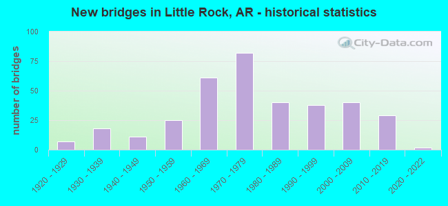
- New bridges - historical statistics
- 71920-1929
- 181930-1939
- 111940-1949
- 251950-1959
- 611960-1969
- 821970-1979
- 401980-1989
- 381990-1999
- 402000-2009
- 292010-2019
- 22020-2022

- Reconstructed bridges - Historical Statistics
- 11950-1959
- 21960-1969
- 201970-1979
- 131980-1989
- 51990-1999
- 22000-2009
- 42010-2019


- Bridge Condition - Deck
- 3.1%Excellent
- 13.0%Very good
- 41.4%Good
- 32.6%Satisfactory
- 9.6%Fair
- 0.4%Poor

- Bridge Condition - Superstructure
- 3.4%Excellent
- 18.8%Very good
- 31.0%Good
- 29.9%Satisfactory
- 14.6%Fair
- 2.3%Poor

- Bridge Condition - Substructure
- 2.3%Excellent
- 16.1%Very good
- 34.9%Good
- 33.3%Satisfactory
- 13.0%Fair
- 0.4%Poor

- Bridge Condition - Channel
- 21.8%Excellent
- 41.1%Very good
- 27.0%Good
- 9.3%Satisfactory
- 0.8%Fair
- 0.4%Poor

- Bridge Condition - Culverts
- 5.4%Excellent
- 20.7%Very good
- 51.1%Good
- 21.7%Satisfactory
- 1.1%Fair
Find on map >> Show street view
Structure Number: 3332, Location: SO TERMINAL INTCHG (Lat: 34.708361, Lng: -92.270989), Route carried "under" structure: Ramp Interstate 530, Structure Length: 0. m, Average Daily Traffic: 44,000 (year 2013), Truck Traffic: 1%, Features Intersected: I-530 / I-30 SW RAMP
Minimum Vertical Clearance: 5.18m (16.99ft), Kilometerpoint: 0.579, Length of Maximum Span: 0.0m
Find on map >> Show street view
Structure Number: 344, Location: I-30 OFF RAMP (Lat: 34.746131, Lng: -92.263550), Route carried "under" structure: City street 64450, Structure Length: 0. m, Average Daily Traffic: 1,445 (year 2000), Truck Traffic: 1%, Features Intersected: 2ND ST., Facility Carried by Structure: SH 10-SEC 8Y
Minimum Vertical Clearance: 7.10m (23.29ft), Kilometerpoint: 0.612, Length of Maximum Span: 0.0m
Find on map >> Show street view
Structure Number: 3441, Location: OFF RAMP I-30 (Lat: 34.746489, Lng: -92.264300), Route carried "under" structure: City street 64450, Structure Length: 0. m, Average Daily Traffic: 1,445 (year 2000), Truck Traffic: 1%, Features Intersected: 2ND ST., Facility Carried by Structure: SH 10-SEC 8Y
Minimum Vertical Clearance: 4.44m (14.57ft), Kilometerpoint: 0.612, Length of Maximum Span: 0.0m
Find on map >> Show street view
Structure Number: 3491, Location: 4.3 MI E OF I-30 (Lat: 34.745389, Lng: -92.334489), Route carried "under" structure: Interstate 630, Structure Length: 0. m, Average Daily Traffic: 56,000 (year 2014), Truck Traffic: 1%, Features Intersected: I-630 LOG 4.09, Facility Carried by Structure: FAIR PARK BLVD
Minimum Vertical Clearance: 4.49m (14.73ft), Kilometerpoint: 6.581, Length of Maximum Span: 0.0m
Find on map >> Show street view
Structure Number: 3491, Location: 4.3 MI E OF I-30 (Lat: 34.745389, Lng: -92.334489), Route carried "under" structure: Interstate 630, Structure Length: 0. m, Average Daily Traffic: 56,000 (year 2014), Truck Traffic: 1%, Features Intersected: I-630 LOG 4.09, Facility Carried by Structure: FAIR PARK BLVD
Minimum Vertical Clearance: 4.60m (15.09ft), Kilometerpoint: 6.581, Length of Maximum Span: 0.0m
Find on map >> Show street view
Structure Number: 3492, Location: 4.01 MI W I-30 (Lat: 34.744919, Lng: -92.329261), Route carried "under" structure: Interstate 630, Structure Length: 0. m, Average Daily Traffic: 44,500 (year 2014), Truck Traffic: 1%, Features Intersected: I 630 SEC 21 LOG 3.80, Facility Carried by Structure: JONESBORO STREET
Minimum Vertical Clearance: 4.84m (15.88ft), Kilometerpoint: 6.114, Length of Maximum Span: 0.0m
Find on map >> Show street view
Structure Number: 3492, Location: 4.01 MI W I-30 (Lat: 34.744919, Lng: -92.329261), Route carried "under" structure: Interstate 630, Structure Length: 0. m, Average Daily Traffic: 44,500 (year 2014), Truck Traffic: 1%, Features Intersected: I 630 SEC 21 LOG 3.80, Facility Carried by Structure: JONESBORO STREET
Minimum Vertical Clearance: 4.78m (15.68ft), Kilometerpoint: 6.114, Length of Maximum Span: 0.0m
Find on map >> Show street view
Structure Number: 3494, Location: 3.35 MI W INT I-30 (Lat: 34.744839, Lng: -92.317689), Route carried "under" structure: Interstate 630, Structure Length: 0. m, Average Daily Traffic: 49,000 (year 2014), Truck Traffic: 1%, Features Intersected: I 630 SEC 21 LOG 3.14, Facility Carried by Structure: CEDAR STREET
Minimum Vertical Clearance: 5.53m (18.14ft), Kilometerpoint: 5.052, Length of Maximum Span: 0.0m
Find on map >> Show street view
Structure Number: 3494, Location: 3.35 MI W INT I-30 (Lat: 34.744839, Lng: -92.317689), Route carried "under" structure: Interstate 630, Structure Length: 0. m, Average Daily Traffic: 49,000 (year 2014), Truck Traffic: 1%, Features Intersected: I 630 SEC 21 LOG 3.14, Facility Carried by Structure: CEDAR STREET
Minimum Vertical Clearance: 6.27m (20.57ft), Kilometerpoint: 5.052, Length of Maximum Span: 0.0m
Find on map >> Show street view
Structure Number: 3495, Location: 3.29 MI W OF I-30 (Lat: 34.744811, Lng: -92.316589), Route carried "under" structure: Interstate 630, Structure Length: 0. m, Average Daily Traffic: 53,500 (year 2014), Truck Traffic: 1%, Features Intersected: I 630 SEC 21 LOG 3.08, Facility Carried by Structure: PINE STREET
Minimum Vertical Clearance: 4.95m (16.24ft), Kilometerpoint: 4.957, Length of Maximum Span: 0.0m
Find on map >> Show street view
Structure Number: 3495, Location: 3.29 MI W OF I-30 (Lat: 34.744811, Lng: -92.316589), Route carried "under" structure: Interstate 630, Structure Length: 0. m, Average Daily Traffic: 53,500 (year 2014), Truck Traffic: 1%, Features Intersected: I 630 SEC 21 LOG 3.08, Facility Carried by Structure: PINE STREET
Minimum Vertical Clearance: 4.80m (15.75ft), Kilometerpoint: 4.957, Length of Maximum Span: 0.0m
Find on map >> Show street view
Structure Number: 3496, Location: 2.78 MI W I-30 (Lat: 34.744061, Lng: -92.307611), Route carried "under" structure: Ramp Interstate 630, Structure Length: 0. m, Average Daily Traffic: 53,500 (year 2013), Truck Traffic: 1%, Features Intersected: I 630 SEC 21 Log 2.57, Facility Carried by Structure: PEDESTRIAN WALKWAY
Minimum Vertical Clearance: 4.49m (14.73ft), Kilometerpoint: 4.134, Length of Maximum Span: 0.0m
Find on map >> Show street view
Structure Number: 3496, Location: 2.78 MI W I-30 (Lat: 34.744061, Lng: -92.307611), Route carried "under" structure: Interstate 630, Structure Length: 0. m, Average Daily Traffic: 53,500 (year 2013), Truck Traffic: 1%, Features Intersected: I 630 SEC 21 Log 2.57, Facility Carried by Structure: PEDESTRIAN WALKWAY
Minimum Vertical Clearance: 4.78m (15.68ft), Kilometerpoint: 4.134, Length of Maximum Span: 0.0m
Find on map >> Show street view
Structure Number: 3496, Location: 2.78 MI W I-30 (Lat: 34.744061, Lng: -92.307611), Route carried "under" structure: Interstate 630, Structure Length: 0. m, Average Daily Traffic: 53,500 (year 2013), Truck Traffic: 1%, Features Intersected: I 630 SEC 21 Log 2.57, Facility Carried by Structure: PEDESTRIAN WALKWAY
Minimum Vertical Clearance: 4.67m (15.32ft), Kilometerpoint: 4.134, Length of Maximum Span: 0.0m
Find on map >> Show street view
Structure Number: 3496, Location: 2.78 MI W I-30 (Lat: 34.744061, Lng: -92.307611), Route carried "under" structure: Ramp Interstate 630, Structure Length: 0. m, Average Daily Traffic: 53,500 (year 2013), Truck Traffic: 1%, Features Intersected: I 630 SEC 21 Log 2.57, Facility Carried by Structure: PEDESTRIAN WALKWAY
Minimum Vertical Clearance: 4.63m (15.19ft), Kilometerpoint: 4.134, Length of Maximum Span: 0.0m
Find on map >> Show street view
Structure Number: 3497, Location: JCT I-630 & WOODROW ST. (Lat: 34.743739, Lng: -92.305581), Route carried "under" structure: Interstate 630, Structure Length: 0. m, Average Daily Traffic: 44,500 (year 2014), Truck Traffic: 1%, Features Intersected: I 630 SEC 21 Log 2.43, Facility Carried by Structure: WOODROW STREET
Minimum Vertical Clearance: 4.90m (16.08ft), Kilometerpoint: 3.911, Length of Maximum Span: 0.0m
Find on map >> Show street view
Structure Number: 3497, Location: JCT I-630 & WOODROW ST. (Lat: 34.743739, Lng: -92.305581), Route carried "under" structure: Interstate 630, Structure Length: 0. m, Average Daily Traffic: 44,500 (year 2014), Truck Traffic: 1%, Features Intersected: I 630 SEC 21 Log 2.43, Facility Carried by Structure: WOODROW STREET
Minimum Vertical Clearance: 5.76m (18.90ft), Kilometerpoint: 3.911, Length of Maximum Span: 0.0m
Find on map >> Show street view
Structure Number: 35, Location: 2.1 MI W JCT I-30 (Lat: 34.743711, Lng: -92.293869), Route carried "under" structure: Interstate 630, Structure Length: 0. m, Average Daily Traffic: 44,500 (year 2014), Truck Traffic: 1%, Features Intersected: I 630-SEC 21 Log 1.77, Facility Carried by Structure: BATTERY STREET
Minimum Vertical Clearance: 5.56m (18.24ft), Kilometerpoint: 2.849, Length of Maximum Span: 0.0m
Find on map >> Show street view
Structure Number: 35, Location: 2.1 MI W JCT I-30 (Lat: 34.743711, Lng: -92.293869), Route carried "under" structure: Interstate 630, Structure Length: 0. m, Average Daily Traffic: 44,500 (year 2014), Truck Traffic: 1%, Features Intersected: I 630-SEC 21 Log 1.77, Facility Carried by Structure: BATTERY STREET
Minimum Vertical Clearance: 6.95m (22.80ft), Kilometerpoint: 2.849, Length of Maximum Span: 0.0m
Find on map >> Show street view
Structure Number: 35, Location: 2.1 MI W JCT I-30 (Lat: 34.743711, Lng: -92.293869), Route carried "under" structure: Ramp Interstate 630, Structure Length: 0. m, Average Daily Traffic: 44,500 (year 2014), Truck Traffic: 1%, Features Intersected: I 630-SEC 21 Log 1.77, Facility Carried by Structure: BATTERY STREET
Minimum Vertical Clearance: 4.97m (16.31ft), Kilometerpoint: 2.849, Length of Maximum Span: 0.0m
Find on map >> Show street view
Structure Number: 35, Location: 2.1 MI W JCT I-30 (Lat: 34.743711, Lng: -92.293869), Route carried "under" structure: Ramp Interstate 630, Structure Length: 0. m, Average Daily Traffic: 44,500 (year 2014), Truck Traffic: 1%, Features Intersected: I 630-SEC 21 Log 1.77, Facility Carried by Structure: BATTERY STREET
Minimum Vertical Clearance: 6.80m (22.31ft), Kilometerpoint: 2.849, Length of Maximum Span: 0.0m
Find on map >> Show street view
Structure Number: 3501, Location: .02 M SO JCT 7TH ST (Lat: 34.744050, Lng: -92.291450), Route carried "under" structure: Interstate 630, Structure Length: 0. m, Average Daily Traffic: 49,500 (year 2014), Truck Traffic: 1%, Features Intersected: I 630-SEC 21 Log 1.64, Facility Carried by Structure: MARSHALL STREET
Minimum Vertical Clearance: 5.07m (16.63ft), Kilometerpoint: 2.639, Length of Maximum Span: 0.0m
Find on map >> Show street view
Structure Number: 3501, Location: .02 M SO JCT 7TH ST (Lat: 34.744050, Lng: -92.291450), Route carried "under" structure: Interstate 630, Structure Length: 0. m, Average Daily Traffic: 49,505 (year 2014), Truck Traffic: 1%, Features Intersected: I 630-SEC 21 Log 1.64, Facility Carried by Structure: MARSHALL STREET
Minimum Vertical Clearance: 6.01m (19.72ft), Kilometerpoint: 2.639, Length of Maximum Span: 0.0m
Find on map >> Show street view
Structure Number: 3502, Location: 1.7 MI W OF JCT I-30 (Lat: 34.743769, Lng: -92.288219), Route carried "under" structure: Interstate 630, Structure Length: 0. m, Average Daily Traffic: 55,500 (year 2014), Truck Traffic: 1%, Features Intersected: I 630-SEC 21 Log 1.45, Facility Carried by Structure: DR MARTIN L. KING
Minimum Vertical Clearance: 5.05m (16.57ft), Kilometerpoint: 2.334, Length of Maximum Span: 0.0m
Find on map >> Show street view
Structure Number: 3502, Location: 1.7 MI W OF JCT I-30 (Lat: 34.743769, Lng: -92.288219), Route carried "under" structure: Interstate 630, Structure Length: 0. m, Average Daily Traffic: 55,500 (year 2014), Truck Traffic: 1%, Features Intersected: I 630-SEC 21 Log 1.45, Facility Carried by Structure: DR MARTIN L. KING
Minimum Vertical Clearance: 5.53m (18.14ft), Kilometerpoint: 2.334, Length of Maximum Span: 0.0m
Find on map >> Show street view
Structure Number: 3503, Location: 1.3 MI W JCT I-30 (Lat: 34.741719, Lng: -92.282619), Route carried "under" structure: Interstate 630, Structure Length: 0. m, Average Daily Traffic: 55,500 (year 2014), Truck Traffic: 1%, Features Intersected: I 630-SEC 21 Log 1.10, Facility Carried by Structure: CHESTER STREET
Minimum Vertical Clearance: 5.46m (17.91ft), Kilometerpoint: 1.770, Length of Maximum Span: 0.0m
Find on map >> Show street view
Structure Number: 3503, Location: 1.3 MI W JCT I-30 (Lat: 34.741719, Lng: -92.282619), Route carried "under" structure: Interstate 630, Structure Length: 0. m, Average Daily Traffic: 55,500 (year 2014), Truck Traffic: 1%, Features Intersected: I 630-SEC 21 Log 1.10, Facility Carried by Structure: CHESTER STREET
Minimum Vertical Clearance: 5.71m (18.73ft), Kilometerpoint: 1.770, Length of Maximum Span: 0.0m
Find on map >> Show street view
Structure Number: 3503, Location: 1.3 MI W JCT I-30 (Lat: 34.741719, Lng: -92.282619), Route carried "under" structure: Ramp Interstate 630, Structure Length: 0. m, Average Daily Traffic: 55,500 (year 2014), Truck Traffic: 1%, Features Intersected: I 630-SEC 21 Log 1.10, Facility Carried by Structure: CHESTER STREET
Minimum Vertical Clearance: 5.15m (16.90ft), Kilometerpoint: 1.770, Length of Maximum Span: 0.0m
Find on map >> Show street view
Structure Number: 3503, Location: 1.3 MI W JCT I-30 (Lat: 34.741719, Lng: -92.282619), Route carried "under" structure: Ramp Interstate 630, Structure Length: 0. m, Average Daily Traffic: 55,500 (year 2014), Truck Traffic: 1%, Features Intersected: I 630-SEC 21 Log 1.10, Facility Carried by Structure: CHESTER STREET
Minimum Vertical Clearance: 5.46m (17.91ft), Kilometerpoint: 1.770, Length of Maximum Span: 0.0m
Find on map >> Show street view
Structure Number: 3504, Location: 1.2 MI W JCT I-30 (Lat: 34.740619, Lng: -92.280389), Route carried "under" structure: Interstate 630, Structure Length: 0. m, Average Daily Traffic: 52,500 (year 2014), Truck Traffic: 1%, Features Intersected: I 630-SEC 21 Log 0.97, Facility Carried by Structure: STATE STREET
Minimum Vertical Clearance: 5.05m (16.57ft), Kilometerpoint: 1.561, Length of Maximum Span: 0.0m
Find on map >> Show street view
Structure Number: 3504, Location: 1.2 MI W JCT I-30 (Lat: 34.740619, Lng: -92.280389), Route carried "under" structure: Interstate 630, Structure Length: 0. m, Average Daily Traffic: 52,500 (year 2014), Truck Traffic: 1%, Features Intersected: I 630-SEC 21 Log 0.97, Facility Carried by Structure: STATE STREET
Minimum Vertical Clearance: 5.66m (18.57ft), Kilometerpoint: 1.561, Length of Maximum Span: 0.0m
Find on map >> Show street view
Structure Number: 3506, Location: 7.8 MI N JCT I-30 (Lat: 34.739019, Lng: -92.277050), Route carried "under" structure: Interstate 630, Structure Length: 0. m, Average Daily Traffic: 52,500 (year 2014), Truck Traffic: 1%, Features Intersected: I 630-SEC 21 Log 0.74, Facility Carried by Structure: US 70 (BROADWAY)
Minimum Vertical Clearance: 4.93m (16.17ft), Kilometerpoint: 1.191, Length of Maximum Span: 0.0m
Find on map >> Show street view
Structure Number: 3506, Location: 7.8 MI N JCT I-30 (Lat: 34.739019, Lng: -92.277050), Route carried "under" structure: Ramp Interstate 630, Structure Length: 0. m, Average Daily Traffic: 52,500 (year 2014), Truck Traffic: 1%, Features Intersected: I 630-SEC 21 Log 0.74, Facility Carried by Structure: US 70 (BROADWAY)
Minimum Vertical Clearance: 5.63m (18.47ft), Kilometerpoint: 1.239, Length of Maximum Span: 0.0m
Find on map >> Show street view
Structure Number: 3506, Location: 7.8 MI N JCT I-30 (Lat: 34.739019, Lng: -92.277050), Route carried "under" structure: Interstate 630, Structure Length: 0. m, Average Daily Traffic: 52,500 (year 2014), Truck Traffic: 1%, Features Intersected: I 630-SEC 21 Log 0.74, Facility Carried by Structure: US 70 (BROADWAY)
Minimum Vertical Clearance: 5.33m (17.49ft), Kilometerpoint: 1.191, Length of Maximum Span: 0.0m
Find on map >> Show street view
Structure Number: 3506, Location: 7.8 MI N JCT I-30 (Lat: 34.739019, Lng: -92.277050), Route carried "under" structure: Ramp Interstate 630, Structure Length: 0. m, Average Daily Traffic: 52,500 (year 2014), Truck Traffic: 1%, Features Intersected: I 630-SEC 21 Log 0.74, Facility Carried by Structure: US 70 (BROADWAY)
Minimum Vertical Clearance: 4.90m (16.08ft), Kilometerpoint: 1.239, Length of Maximum Span: 0.0m
Find on map >> Show street view
Structure Number: 3507, Location: .82 MI W JCT I-30 (Lat: 34.738811, Lng: -92.274611), Route carried "under" structure: Interstate 630, Structure Length: 0. m, Average Daily Traffic: 39,000 (year 2014), Truck Traffic: 1%, Features Intersected: I 630-SEC 21 Log 0.60, Facility Carried by Structure: CENTER STREET
Minimum Vertical Clearance: 4.95m (16.24ft), Kilometerpoint: 0.966, Length of Maximum Span: 0.0m
Find on map >> Show street view
Structure Number: 3507, Location: .82 MI W JCT I-30 (Lat: 34.738811, Lng: -92.274611), Route carried "under" structure: Interstate 630, Structure Length: 0. m, Average Daily Traffic: 39,000 (year 2014), Truck Traffic: 1%, Features Intersected: I 630-SEC 21 Log 0.60, Facility Carried by Structure: CENTER STREET
Minimum Vertical Clearance: 5.00m (16.40ft), Kilometerpoint: 0.966, Length of Maximum Span: 0.0m
Find on map >> Show street view
Structure Number: 3508, Location: 0.49 MI W JCT I-30&I-630 (Lat: 34.738581, Lng: -92.273831), Route carried "under" structure: Interstate 630, Structure Length: 0. m, Average Daily Traffic: 39,000 (year 2014), Truck Traffic: 1%, Features Intersected: I 630-SEC 21 Log 0.49, Facility Carried by Structure: LOUISIANA ST.
Minimum Vertical Clearance: 5.02m (16.47ft), Kilometerpoint: 0.789, Length of Maximum Span: 0.0m
Find on map >> Show street view
Structure Number: 351, Location: .7 MI W JCT I-30 (Lat: 34.738169, Lng: -92.272281), Route carried "under" structure: Ramp Interstate 630, Structure Length: 0. m, Average Daily Traffic: 43,000 (year 2014), Truck Traffic: 1%, Features Intersected: I 630-SEC 21 Log 0.46, Facility Carried by Structure: MAIN STREET
Minimum Vertical Clearance: 5.12m (16.80ft), Kilometerpoint: 0.740, Length of Maximum Span: 0.0m
Find on map >> Show street view
Structure Number: 351, Location: .7 MI W JCT I-30 (Lat: 34.738169, Lng: -92.272281), Route carried "under" structure: Ramp Interstate 630, Structure Length: 0. m, Average Daily Traffic: 43,000 (year 2014), Truck Traffic: 1%, Features Intersected: I 630-SEC 21 Log 0.46, Facility Carried by Structure: MAIN STREET
Minimum Vertical Clearance: 5.02m (16.47ft), Kilometerpoint: 0.740, Length of Maximum Span: 0.0m
Find on map >> Show street view
Structure Number: 351, Location: .7 MI W JCT I-30 (Lat: 34.738169, Lng: -92.272281), Route carried "under" structure: Interstate 630, Structure Length: 0. m, Average Daily Traffic: 43,000 (year 2014), Features Intersected: I 630-SEC 21 Log 0.46, Facility Carried by Structure: MAIN STREET
Minimum Vertical Clearance: 5.91m (19.39ft), Kilometerpoint: 0.740, Length of Maximum Span: 0.0m
Find on map >> Show street view
Structure Number: 351, Location: .7 MI W JCT I-30 (Lat: 34.738169, Lng: -92.272281), Route carried "under" structure: Interstate 630, Structure Length: 0. m, Average Daily Traffic: 43,000 (year 2014), Truck Traffic: 1%, Features Intersected: I 630-SEC 21 Log 0.46, Facility Carried by Structure: MAIN STREET
Minimum Vertical Clearance: 6.24m (20.47ft), Kilometerpoint: 0.740, Length of Maximum Span: 0.0m
Find on map >> Show street view
Structure Number: 3511, Location: .6 MI W OF I-30 (Lat: 34.737800, Lng: -92.271111), Route carried "under" structure: Ramp Interstate 630, Structure Length: 0. m, Average Daily Traffic: 43,000 (year 2014), Truck Traffic: 1%, Features Intersected: I 630-SEC 21 Log 0.39, Facility Carried by Structure: SCOTT STREET
Minimum Vertical Clearance: 6.93m (22.74ft), Kilometerpoint: 0.628, Length of Maximum Span: 0.0m
Find on map >> Show street view
Structure Number: 3511, Location: .6 MI W OF I-30 (Lat: 34.737800, Lng: -92.271111), Route carried "under" structure: Interstate 630, Structure Length: 0. m, Average Daily Traffic: 43,000 (year 2014), Truck Traffic: 1%, Features Intersected: I 630-SEC 21 Log 0.39, Facility Carried by Structure: SCOTT STREET
Minimum Vertical Clearance: 5.85m (19.19ft), Kilometerpoint: 0.628, Length of Maximum Span: 0.0m
Find on map >> Show street view
Structure Number: 3511, Location: .6 MI W OF I-30 (Lat: 34.737800, Lng: -92.271111), Route carried "under" structure: Interstate 630, Structure Length: 0. m, Average Daily Traffic: 43,000 (year 2014), Truck Traffic: 1%, Features Intersected: I 630-SEC 21 Log 0.39, Facility Carried by Structure: SCOTT STREET
Minimum Vertical Clearance: 6.88m (22.57ft), Kilometerpoint: 0.628, Length of Maximum Span: 0.0m
Find on map >> Show street view
Structure Number: 3512, Location: .53 MI W JCT I-30 (Lat: 34.737239, Lng: -92.270000), Route carried "under" structure: Interstate 630, Structure Length: 0. m, Average Daily Traffic: 44,500 (year 2014), Truck Traffic: 1%, Features Intersected: I 630-SEC 21 Log 0.35, Facility Carried by Structure: CUMBERLAND STREET
Minimum Vertical Clearance: 5.85m (19.19ft), Kilometerpoint: 0.563, Length of Maximum Span: 0.0m
Find on map >> Show street view
Structure Number: 3512, Location: .53 MI W JCT I-30 (Lat: 34.737239, Lng: -92.270000), Route carried "under" structure: Interstate 630, Structure Length: 0. m, Average Daily Traffic: 44,500 (year 2014), Truck Traffic: 1%, Features Intersected: I 630-SEC 21 Log 0.35, Facility Carried by Structure: CUMBERLAND STREET
Minimum Vertical Clearance: 5.00m (16.40ft), Kilometerpoint: 0.563, Length of Maximum Span: 0.0m
Find on map >> Show street view
Structure Number: 3513, Location: .34 M W OF I-30 (Lat: 34.735719, Lng: -92.267861), Route carried "under" structure: Interstate 630, Structure Length: 0. m, Average Daily Traffic: 44,500 (year 2014), Truck Traffic: 1%, Features Intersected: I 630-SEC 21 Log 0.16, Facility Carried by Structure: COMMERCE STREET
Minimum Vertical Clearance: 5.69m (18.67ft), Kilometerpoint: 0.257, Length of Maximum Span: 0.0m
Find on map >> Show street view
Structure Number: 3513, Location: .34 M W OF I-30 (Lat: 34.735719, Lng: -92.267861), Route carried "under" structure: Interstate 630, Structure Length: 0. m, Average Daily Traffic: 44,500 (year 2014), Truck Traffic: 1%, Features Intersected: I 630-SEC 21 Log 0.16, Facility Carried by Structure: COMMERCE STREET
Minimum Vertical Clearance: 5.02m (16.47ft), Kilometerpoint: 0.257, Length of Maximum Span: 0.0m
Find on map >> Show street view
Structure Number: 3514, Location: .2 MI W JCT I-30 (Lat: 34.733889, Lng: -92.265869), Route carried "under" structure: Interstate 630, Structure Length: 0. m, Average Daily Traffic: 44,500 (year 2014), Truck Traffic: 1%, Features Intersected: I 630-SEC 21 Log 0.10, Facility Carried by Structure: MACARTHUR Pk Pd OP
Minimum Vertical Clearance: 4.96m (16.27ft), Kilometerpoint: 0.161, Length of Maximum Span: 0.0m
Find on map >> Show street view
Structure Number: 3514, Location: .2 MI W JCT I-30 (Lat: 34.733889, Lng: -92.265869), Route carried "under" structure: Interstate 630, Structure Length: 0. m, Average Daily Traffic: 44,500 (year 2014), Truck Traffic: 1%, Features Intersected: I 630-SEC 21 Log 0.10, Facility Carried by Structure: MACARTHUR Pk Pd OP
Minimum Vertical Clearance: 5.79m (19.00ft), Kilometerpoint: 0.161, Length of Maximum Span: 0.0m
Find on map >> Show street view
Structure Number: 3514, Location: .2 MI W JCT I-30 (Lat: 34.733889, Lng: -92.265869), Route carried "under" structure: City street 7167, Structure Length: 0. m, Average Daily Traffic: 50 (year 1992), Features Intersected: I 630 / 14th St., Facility Carried by Structure: MACARTHUR Pk Pd OP
Minimum Vertical Clearance: 4.78m (15.68ft), Kilometerpoint: 0.016, Length of Maximum Span: 0.0m
Find on map >> Show street view
Structure Number: 521, Location: 1.87 SO OF SH 338 (Lat: 34.617719, Lng: -92.269319), Route carried "under" structure: Interstate 530, Structure Length: 0. m, Average Daily Traffic: 16,500 (year 2012), Truck Traffic: 1%, Features Intersected: I 530 SEC 1/0 Log 6.70, Facility Carried by Structure: PRATT RD.
Minimum Vertical Clearance: 5.08m (16.67ft), Kilometerpoint: 10.783, Length of Maximum Span: 0.0m
Find on map >> Show street view
Structure Number: 521, Location: 1.87 SO OF SH 338 (Lat: 34.617719, Lng: -92.269319), Route carried "under" structure: Interstate 530, Structure Length: 0. m, Average Daily Traffic: 16,500 (year 2012), Truck Traffic: 1%, Features Intersected: I 530 SEC 1/0 Log 6.70, Facility Carried by Structure: PRATT RD.
Minimum Vertical Clearance: 5.00m (16.40ft), Kilometerpoint: 10.783, Length of Maximum Span: 0.0m
Find on map >> Show street view
Structure Number: 5292, Location: SH 5 RIVER BR AT L.R. (Lat: 34.748631, Lng: -92.269131), Route carried "under" structure: City street 49137, Structure Length: 0. m, Features Intersected: Riverfront Dr., Facility Carried by Structure: SH 5/MAIN STREET
Minimum Vertical Clearance: 4.87m (15.98ft), Kilometerpoint: 1.275, Length of Maximum Span: 0.0m
Find on map >> Show street view
Structure Number: 5292, Location: SH 5 RIVER BR AT L.R. (Lat: 34.748631, Lng: -92.269131), Route carried "under" structure: State highway 10, Structure Length: 0. m, Features Intersected: SH 10, Facility Carried by Structure: SH 5/MAIN STREET
Minimum Vertical Clearance: 5.05m (16.57ft), Kilometerpoint: 25.487, Length of Maximum Span: 0.0m
Find on map >> Show street view
Structure Number: 5292, Location: SH 5 RIVER BR AT L.R. (Lat: 34.748631, Lng: -92.269131), Route carried "under" structure: State highway 10, Structure Length: 0. m, Features Intersected: SH 10, Facility Carried by Structure: SH 5/MAIN STREET
Minimum Vertical Clearance: 4.54m (14.90ft), Kilometerpoint: 25.487, Length of Maximum Span: 0.0m
Find on map >> Show street view
Structure Number: 5292, Location: SH 5 RIVER BR AT L.R. (Lat: 34.748631, Lng: -92.269131), Route carried "under" structure: City street 49137, Structure Length: 0. m, Features Intersected: Riverfront Dr., Facility Carried by Structure: SH 5/MAIN STREET
Minimum Vertical Clearance: 5.36m (17.59ft), Kilometerpoint: 1.275, Length of Maximum Span: 0.0m
Find on map >> Show street view
Structure Number: 5305, Location: 0.6 MI S OF SH 338 (Lat: 34.661450, Lng: -92.402331), Route carried "under" structure: Interstate 30, Structure Length: 0. m, Average Daily Traffic: 46,000 (year 2014), Truck Traffic: 1%, Features Intersected: I-30 LOG 129.23
Minimum Vertical Clearance: 5.45m (17.88ft), Kilometerpoint: 207.930, Length of Maximum Span: 0.0m
Find on map >> Show street view
Structure Number: 5305, Location: 0.6 MI S OF SH 338 (Lat: 34.661450, Lng: -92.402331), Route carried "under" structure: Interstate 30, Structure Length: 0. m, Average Daily Traffic: 46,000 (year 2014), Truck Traffic: 1%, Features Intersected: I-30 LOG 129.23
Minimum Vertical Clearance: 5.23m (17.16ft), Kilometerpoint: 207.930, Length of Maximum Span: 0.0m
Find on map >> Show street view
Structure Number: 5308, Location: 1 MI N OF I-30 (Lat: 34.678681, Lng: -92.407161), Route carried "under" structure: Interstate 430, Structure Length: 0. m, Average Daily Traffic: 32,500 (year 2014), Truck Traffic: 1%, Features Intersected: I 430-LOG 1.24, Facility Carried by Structure: SH 5 Log 3.28
Minimum Vertical Clearance: 4.90m (16.08ft), Kilometerpoint: 1.996, Length of Maximum Span: 0.0m
Find on map >> Show street view
Structure Number: 5308, Location: 1 MI N OF I-30 (Lat: 34.678681, Lng: -92.407161), Route carried "under" structure: Interstate 430, Structure Length: 0. m, Average Daily Traffic: 32,500 (year 2014), Truck Traffic: 1%, Features Intersected: I 430-LOG 1.24, Facility Carried by Structure: SH 5 Log 3.28
Minimum Vertical Clearance: 5.12m (16.80ft), Kilometerpoint: 1.996, Length of Maximum Span: 0.0m
Find on map >> Show street view
Structure Number: 5309, Location: 1 MI N SH 5 (Lat: 34.696261, Lng: -92.404331), Route carried "under" structure: Interstate 430, Structure Length: 0. m, Average Daily Traffic: 37,500 (year 2014), Truck Traffic: 1%, Features Intersected: I 430-LOG 0.88, Facility Carried by Structure: David O. Dodd Rd
Minimum Vertical Clearance: 5.08m (16.67ft), Kilometerpoint: 3.911, Length of Maximum Span: 0.0m
Find on map >> Show street view
Structure Number: 5309, Location: 1 MI N SH 5 (Lat: 34.696261, Lng: -92.404331), Route carried "under" structure: Interstate 430, Structure Length: 0. m, Average Daily Traffic: 37,500 (year 2014), Truck Traffic: 1%, Features Intersected: I 430-LOG 0.88, Facility Carried by Structure: David O. Dodd Rd
Minimum Vertical Clearance: 5.28m (17.32ft), Kilometerpoint: 3.911, Length of Maximum Span: 0.0m
Find on map >> Show street view
Structure Number: 5312, Location: 0.95 MI S OF I-630 (Lat: 34.736250, Lng: -92.394561), Route carried "under" structure: Interstate 430, Structure Length: 0. m, Average Daily Traffic: 39,000 (year 2013), Truck Traffic: 1%, Features Intersected: I 430-LOG 5.33, Facility Carried by Structure: SHACKLEFORD ROAD
Minimum Vertical Clearance: 6.12m (20.08ft), Kilometerpoint: 8.576, Length of Maximum Span: 0.0m
Find on map >> Show street view
Structure Number: 5312, Location: 0.95 MI S OF I-630 (Lat: 34.736250, Lng: -92.394561), Route carried "under" structure: Interstate 430, Structure Length: 0. m, Average Daily Traffic: 39,000 (year 2013), Truck Traffic: 1%, Features Intersected: I 430-LOG 5.33, Facility Carried by Structure: SHACKLEFORD ROAD
Minimum Vertical Clearance: 4.87m (15.98ft), Kilometerpoint: 8.576, Length of Maximum Span: 0.0m
Find on map >> Show street view
Structure Number: 5313, Location: 0.37 MI S OF I-630 (Lat: 34.742989, Lng: -92.391631), Route carried "under" structure: Interstate 430, Structure Length: 0. m, Average Daily Traffic: 38,000 (year 2014), Truck Traffic: 1%, Features Intersected: I 430-LOG 5.92, Facility Carried by Structure: KANIS RD
Minimum Vertical Clearance: 5.96m (19.55ft), Kilometerpoint: 9.526, Length of Maximum Span: 0.0m
Find on map >> Show street view
Structure Number: 5313, Location: 0.37 MI S OF I-630 (Lat: 34.742989, Lng: -92.391631), Route carried "under" structure: Interstate 430, Structure Length: 0. m, Average Daily Traffic: 38,000 (year 2014), Truck Traffic: 1%, Features Intersected: I 430-LOG 5.92, Facility Carried by Structure: KANIS RD
Minimum Vertical Clearance: 5.00m (16.40ft), Kilometerpoint: 9.526, Length of Maximum Span: 0.0m
Find on map >> Show street view
Structure Number: 5313, Location: 0.37 MI S OF I-630 (Lat: 34.742989, Lng: -92.391631), Route carried "under" structure: Ramp Interstate 430, Structure Length: 0. m, Average Daily Traffic: 38,000 (year 2014), Truck Traffic: 1%, Features Intersected: I 430-LOG 5.92, Facility Carried by Structure: KANIS RD
Minimum Vertical Clearance: 7.01m (23.00ft), Kilometerpoint: 9.526, Length of Maximum Span: 0.0m
Find on map >> Show street view
Structure Number: 5315, Location: 0.1 MI N JCT I 630 (Lat: 34.753889, Lng: -92.390981), Route carried "under" structure: Interstate 430, Structure Length: 0. m, Average Daily Traffic: 42,000 (year 2014), Truck Traffic: 1%, Features Intersected: I 430-LOG 6.67, Facility Carried by Structure: W. MARKHAM ST
Minimum Vertical Clearance: 5.05m (16.57ft), Kilometerpoint: 10.733, Length of Maximum Span: 0.0m
Find on map >> Show street view
Structure Number: 5315, Location: 0.1 MI N JCT I 630 (Lat: 34.753889, Lng: -92.390981), Route carried "under" structure: Ramp 630, Structure Length: 0. m, Features Intersected: I 430-LOG 6.67, Facility Carried by Structure: W. MARKHAM ST
Minimum Vertical Clearance: 5.12m (16.80ft), Length of Maximum Span: 0.0m
Find on map >> Show street view
Structure Number: 5315, Location: 0.1 MI N JCT I 630 (Lat: 34.753889, Lng: -92.390981), Route carried "under" structure: Ramp Interstate 430, Structure Length: 0. m, Average Daily Traffic: 42,000 (year 2014), Truck Traffic: 1%, Features Intersected: I 430-LOG 6.67, Facility Carried by Structure: W. MARKHAM ST
Minimum Vertical Clearance: 5.00m (16.40ft), Kilometerpoint: 10.733, Length of Maximum Span: 0.0m
Find on map >> Show street view
Structure Number: 5315, Location: 0.1 MI N JCT I 630 (Lat: 34.753889, Lng: -92.390981), Route carried "under" structure: Interstate 430, Structure Length: 0. m, Average Daily Traffic: 42,000 (year 2014), Truck Traffic: 1%, Features Intersected: I 430-LOG 6.67, Facility Carried by Structure: W. MARKHAM ST
Minimum Vertical Clearance: 5.10m (16.73ft), Kilometerpoint: 10.733, Length of Maximum Span: 0.0m
Find on map >> Show street view
Structure Number: 532, Location: 3 MI S I-40 (Lat: 34.796947, Lng: -92.382678), Route carried "under" structure: City street 49135, Structure Length: 0. m, Average Daily Traffic: 100 (year 1991), Truck Traffic: 1%, Features Intersected: RIVER MT RD,RR,ARK RIVER, Facility Carried by Structure: I 430-SEC 21
Minimum Vertical Clearance: 6.37m (20.90ft), Kilometerpoint: 0.805, Length of Maximum Span: 0.0m
Find on map >> Show street view
Structure Number: 5482, Location: JCT OF I-630&I-30 (Lat: 34.734039, Lng: -92.261219), Route carried "under" structure: Interstate 30, Structure Length: 0. m, Average Daily Traffic: 51,000 (year 2014), Truck Traffic: 1%, Features Intersected: I 30-SEC 23 log 139.67
Minimum Vertical Clearance: 6.82m (22.38ft), Kilometerpoint: 224.761, Length of Maximum Span: 0.0m
Find on map >> Show street view
Structure Number: 5482, Location: JCT OF I-630&I-30 (Lat: 34.734039, Lng: -92.261219), Route carried "under" structure: Interstate 30, Structure Length: 0. m, Average Daily Traffic: 51,000 (year 2014), Truck Traffic: 1%, Features Intersected: I 30-SEC 23 log 139.67
Minimum Vertical Clearance: 6.03m (19.78ft), Kilometerpoint: 224.761, Length of Maximum Span: 0.0m
Find on map >> Show street view
Structure Number: 5484, Location: I 30&I 630 INTCH(I8) (Lat: 34.736219, Lng: -92.260811), Route carried "under" structure: Ramp Interstate 30, Structure Length: 0. m, Average Daily Traffic: 106,000 (year 2013), Truck Traffic: 1%, Features Intersected: I30 EXIT RAMP E
Minimum Vertical Clearance: 5.08m (16.67ft), Kilometerpoint: 225.051, Length of Maximum Span: 0.0m
Find on map >> Show street view
Structure Number: 5485, Location: I-30&I-630 ITRCHG (Lat: 34.735661, Lng: -92.261989), Route carried "under" structure: Ramp Interstate 630, Structure Length: 0. m, Average Daily Traffic: 89,000 (year 2014), Truck Traffic: 1%, Features Intersected: I-30 ON RAMP WB
Minimum Vertical Clearance: 5.02m (16.47ft), Kilometerpoint: 0.002, Length of Maximum Span: 0.0m
Find on map >> Show street view
Structure Number: 5504, Location: 2.8 MI SW JCT SH 338 (Lat: 34.664361, Lng: -92.404069), Route carried "under" structure: Interstate 430, Structure Length: 0. m, Average Daily Traffic: 32,500 (year 2014), Truck Traffic: 1%, Features Intersected: I-430 LOG 0.22, Facility Carried by Structure: I-30 WB FRONTAGE
Minimum Vertical Clearance: 5.02m (16.47ft), Kilometerpoint: 0.354, Length of Maximum Span: 0.0m
Find on map >> Show street view
Structure Number: 5504, Location: 2.8 MI SW JCT SH 338 (Lat: 34.664361, Lng: -92.404069), Route carried "under" structure: Interstate 430, Structure Length: 0. m, Average Daily Traffic: 32,500 (year 2014), Truck Traffic: 1%, Features Intersected: I-430 LOG 0.22, Facility Carried by Structure: I-30 WB FRONTAGE
Minimum Vertical Clearance: 5.05m (16.57ft), Kilometerpoint: 0.354, Length of Maximum Span: 0.0m
Find on map >> Show street view
Structure Number: 5509, Location: .7 MI N JCT I-630 (Lat: 34.757569, Lng: -92.391669), Route carried "under" structure: Interstate 430, Structure Length: 0. m, Average Daily Traffic: 42,000 (year 2014), Truck Traffic: 1%, Features Intersected: I-430-Log 6.92, Facility Carried by Structure: PEDESTRIAN WALKWAY
Minimum Vertical Clearance: 5.10m (16.73ft), Kilometerpoint: 11.133, Length of Maximum Span: 0.0m
Find on map >> Show street view
Structure Number: 5509, Location: .7 MI N JCT I-630 (Lat: 34.757569, Lng: -92.391669), Route carried "under" structure: Interstate 430, Structure Length: 0. m, Average Daily Traffic: 42,000 (year 2014), Truck Traffic: 1%, Features Intersected: I-430-Log 6.92, Facility Carried by Structure: PEDESTRIAN WALKWAY
Minimum Vertical Clearance: 5.33m (17.49ft), Kilometerpoint: 11.133, Length of Maximum Span: 0.0m
Find on map >> Show street view
Structure Number: 5581, Location: 1.1MI E OF I 430 (Lat: 34.747011, Lng: -92.372119), Route carried "under" structure: Interstate 630, Structure Length: 0. m, Average Daily Traffic: 49,500 (year 2014), Truck Traffic: 3%, Features Intersected: I 630-LOG 6.25, Facility Carried by Structure: JOHN BARROW ROAD
Minimum Vertical Clearance: 4.81m (15.78ft), Kilometerpoint: 10.057, Length of Maximum Span: 0.0m
Find on map >> Show street view
Structure Number: 5581, Location: 1.1MI E OF I 430 (Lat: 34.747011, Lng: -92.372119), Route carried "under" structure: Interstate 630, Structure Length: 0. m, Average Daily Traffic: 49,500 (year 2014), Truck Traffic: 3%, Features Intersected: I 630-LOG 6.25, Facility Carried by Structure: JOHN BARROW ROAD
Minimum Vertical Clearance: 5.76m (18.90ft), Kilometerpoint: 10.057, Length of Maximum Span: 0.0m
Find on map >> Show street view
Structure Number: 5698, Location: SO TERMINAL INT (Lat: 34.710669, Lng: -92.275281), Route carried "under" structure: Interstate 30, Structure Length: 0. m, Average Daily Traffic: 45,500 (year 2014), Truck Traffic: 1%, Features Intersected: I-30, I-440 EW LNS
Minimum Vertical Clearance: 4.93m (16.17ft), Kilometerpoint: 221.800, Length of Maximum Span: 0.0m
Find on map >> Show street view
Structure Number: 5698, Location: SO TERMINAL INT (Lat: 34.710669, Lng: -92.275281), Route carried "under" structure: Interstate 30, Structure Length: 0. m, Average Daily Traffic: 45,500 (year 2014), Truck Traffic: 1%, Features Intersected: I-30, I-440 EW LNS
Minimum Vertical Clearance: 5.02m (16.47ft), Kilometerpoint: 221.800, Length of Maximum Span: 0.0m
Find on map >> Show street view
Structure Number: 5698, Location: SO TERMINAL INT (Lat: 34.710669, Lng: -92.275281), Route carried "under" structure: Interstate 440, Structure Length: 0. m, Average Daily Traffic: 54,000 (year 2014), Truck Traffic: 1%, Features Intersected: I-30, I-440 EW LNS, Facility Carried by Structure: I-530 SW RAMP
Minimum Vertical Clearance: 4.96m (16.27ft), Kilometerpoint: 0.354, Length of Maximum Span: 0.0m
Find on map >> Show street view
Structure Number: 5699, Location: SO TERMINAL INTCH (Lat: 34.711569, Lng: -92.270789), Route carried "under" structure: Interstate 30, Structure Length: 0. m, Average Daily Traffic: 91,000 (year 2014), Truck Traffic: 1%, Features Intersected: I-30 EB Log 137.98
Minimum Vertical Clearance: 5.09m (16.70ft), Kilometerpoint: 222.057, Length of Maximum Span: 0.0m
Find on map >> Show street view
Structure Number: 5701, Location: I-440 Log 3.24 Airport Ex (Lat: 34.716011, Lng: -92.224800), Route carried "under" structure: Interstate 440, Structure Length: 0. m, Average Daily Traffic: 27,000 (year 2014), Truck Traffic: 1%, Features Intersected: I440,LR PORT,RR,FOURCHE, Facility Carried by Structure: BANKHEAD DRIVE
Minimum Vertical Clearance: 5.18m (16.99ft), Kilometerpoint: 5.214, Length of Maximum Span: 0.0m
Find on map >> Show street view
Structure Number: 5701, Location: I-440 Log 3.24 Airport Ex (Lat: 34.716011, Lng: -92.224800), Route carried "under" structure: Interstate 440, Structure Length: 0. m, Average Daily Traffic: 27,000 (year 2014), Truck Traffic: 1%, Features Intersected: I440,LR PORT,RR,FOURCHE, Facility Carried by Structure: BANKHEAD DRIVE
Minimum Vertical Clearance: 5.02m (16.47ft), Kilometerpoint: 5.214, Length of Maximum Span: 0.0m
Find on map >> Show street view
Structure Number: 575, Location: 4.9 N JCT SH 338 (Lat: 34.728439, Lng: -92.264650), Route carried "under" structure: Interstate 30, Structure Length: 0. m, Average Daily Traffic: 51,000 (year 2014), Truck Traffic: 1%, Features Intersected: I 30-LOG 139.24, Facility Carried by Structure: E 21ST STREET
Minimum Vertical Clearance: 4.80m (15.75ft), Kilometerpoint: 224.085, Length of Maximum Span: 0.0m
Find on map >> Show street view
Structure Number: 575, Location: 4.9 N JCT SH 338 (Lat: 34.728439, Lng: -92.264650), Route carried "under" structure: Interstate 30, Structure Length: 0. m, Average Daily Traffic: 51,000 (year 2014), Truck Traffic: 1%, Features Intersected: I 30-LOG 139.24, Facility Carried by Structure: E 21ST STREET
Minimum Vertical Clearance: 4.72m (15.49ft), Kilometerpoint: 224.085, Length of Maximum Span: 0.0m
Find on map >> Show street view
Structure Number: 5814, Location: 1.33 MI N US 70 (Lat: 34.742111, Lng: -92.263139), Route carried "under" structure: Interstate 30, Structure Length: 0. m, Average Daily Traffic: 53,000 (year 2013), Truck Traffic: 1%, Features Intersected: I 30 LOG 140.21, Facility Carried by Structure: EAST SIXTH ST.
Minimum Vertical Clearance: 4.77m (15.65ft), Kilometerpoint: 225.646, Length of Maximum Span: 0.0m
Find on map >> Show street view
Structure Number: 5814, Location: 1.33 MI N US 70 (Lat: 34.742111, Lng: -92.263139), Route carried "under" structure: Interstate 30, Structure Length: 0. m, Average Daily Traffic: 53,000 (year 2013), Truck Traffic: 1%, Features Intersected: I 30 LOG 140.21, Facility Carried by Structure: EAST SIXTH ST.
Minimum Vertical Clearance: 4.84m (15.88ft), Kilometerpoint: 225.646, Length of Maximum Span: 0.0m
Find on map >> Show street view
Structure Number: 5992, Location: JCT OF I-630&I-30 (Lat: 34.732919, Lng: -92.261750), Route carried "under" structure: Interstate 30, Structure Length: 0. m, Average Daily Traffic: 51,000 (year 2014), Truck Traffic: 1%, Features Intersected: I-30 Log 139.58
Minimum Vertical Clearance: 5.10m (16.73ft), Kilometerpoint: 224.632, Length of Maximum Span: 0.0m
Find on map >> Show street view
Structure Number: 5992, Location: JCT OF I-630&I-30 (Lat: 34.732919, Lng: -92.261750), Route carried "under" structure: Interstate 30, Structure Length: 0. m, Average Daily Traffic: 51,000 (year 2014), Truck Traffic: 1%, Features Intersected: I-30 Log 139.58
Minimum Vertical Clearance: 5.20m (17.06ft), Kilometerpoint: 224.632, Length of Maximum Span: 0.0m
Find on map >> Show street view
Structure Number: 5993, Location: I630& I630 RAMP A (Lat: 34.733750, Lng: -92.259772), Route carried "under" structure: Interstate 630, Structure Length: 0. m, Average Daily Traffic: 89,000 (year 2014), Truck Traffic: 1%, Features Intersected: I630 RAMP A, BARBER ST
Minimum Vertical Clearance: 5.27m (17.29ft), Kilometerpoint: 0.016, Length of Maximum Span: 0.0m
Find on map >> Show street view
Structure Number: 5993, Location: I630& I630 RAMP A (Lat: 34.733750, Lng: -92.259772), Route carried "under" structure: City street 3190, Structure Length: 0. m, Average Daily Traffic: 3,550 (year 1985), Truck Traffic: 1%, Features Intersected: I630 RAMP A, BARBER ST, Facility Carried by Structure: I630RAMP L, Barber
Minimum Vertical Clearance: 5.51m (18.08ft), Kilometerpoint: 0.002, Length of Maximum Span: 0.0m
Find on map >> Show street view
Structure Number: 5994, Location: JCT I-630&I-30 (Lat: 34.732611, Lng: -92.261669), Route carried "under" structure: Interstate 630, Structure Length: 0. m, Average Daily Traffic: 44,496 (year 2014), Truck Traffic: 1%, Features Intersected: I630 Ramps, I30-Sec 23
Minimum Vertical Clearance: 5.51m (18.08ft), Kilometerpoint: 0.048, Length of Maximum Span: 0.0m
Find on map >> Show street view
Structure Number: 5994, Location: JCT I-630&I-30 (Lat: 34.732611, Lng: -92.261669), Route carried "under" structure: Interstate 630, Structure Length: 0. m, Average Daily Traffic: 44,500 (year 2014), Truck Traffic: 1%, Features Intersected: I630 RAMPS,I30-SEC 23
Minimum Vertical Clearance: 6.30m (20.67ft), Kilometerpoint: 0.048, Length of Maximum Span: 0.0m
Find on map >> Show street view
Structure Number: 5994, Location: JCT I-630&I-30 (Lat: 34.732611, Lng: -92.261669), Route carried "under" structure: Interstate 630, Structure Length: 0. m, Average Daily Traffic: 44,500 (year 2014), Truck Traffic: 1%, Features Intersected: I630 RAMPS,I30-SEC 23
Minimum Vertical Clearance: 6.24m (20.47ft), Kilometerpoint: 0.016, Length of Maximum Span: 0.0m
Find on map >> Show street view
Structure Number: 5994, Location: JCT I-630&I-30 (Lat: 34.732611, Lng: -92.261669), Route carried "under" structure: Interstate 30, Structure Length: 0. m, Average Daily Traffic: 51,000 (year 2014), Truck Traffic: 1%, Features Intersected: I630 RAMPS,I30-SEC 23
Minimum Vertical Clearance: 13.80m (45.28ft), Kilometerpoint: 224.713, Length of Maximum Span: 0.0m
Find on map >> Show street view
Structure Number: 5994, Location: JCT I-630&I-30 (Lat: 34.732611, Lng: -92.261669), Route carried "under" structure: Interstate 30, Structure Length: 0. m, Average Daily Traffic: 51,000 (year 2014), Truck Traffic: 1%, Features Intersected: I630 RAMPS,I30-SEC 23
Minimum Vertical Clearance: 14.87m (48.79ft), Kilometerpoint: 224.713, Length of Maximum Span: 0.0m
Find on map >> Show street view
Structure Number: 6573, Location: 1.22 MI W OF BROADWAY (Lat: 34.748653, Lng: -92.291436), Route carried "under" structure: City street 64454, Structure Length: 0. m, Average Daily Traffic: 800 (year 2004), Truck Traffic: 1%, Features Intersected: UPRR CREEK 2ND ST, Facility Carried by Structure: W 3RD STREET
Minimum Vertical Clearance: 8.47m (27.79ft), Kilometerpoint: 1.963, Length of Maximum Span: 0.0m
Find on map >> Show street view
Structure Number: 671, Location: 0.4 M SE JCT I30/UNIV AVE (Lat: 34.677269, Lng: -92.360919), Route carried "under" structure: ServiceInterstate 30, Structure Length: 0. m, Average Daily Traffic: 39,500 (year 2014), Truck Traffic: 3%, Features Intersected: I-30 SEC 23 Log 131.80, Facility Carried by Structure: CHICOT ROAD
Minimum Vertical Clearance: 5.48m (17.98ft), Kilometerpoint: 212.112, Length of Maximum Span: 0.0m
Find on map >> Show street view
Structure Number: 671, Location: 0.4 M SE JCT I30/UNIV AVE (Lat: 34.677269, Lng: -92.360919), Route carried "under" structure: Interstate 30, Structure Length: 0. m, Average Daily Traffic: 39,500 (year 2014), Truck Traffic: 3%, Features Intersected: I-30 SEC 23 Log 131.80, Facility Carried by Structure: CHICOT ROAD
Minimum Vertical Clearance: 6.33m (20.77ft), Kilometerpoint: 212.112, Length of Maximum Span: 0.0m
Find on map >> Show street view
Structure Number: 671, Location: 0.4 M SE JCT I30/UNIV AVE (Lat: 34.677269, Lng: -92.360919), Route carried "under" structure: Interstate 30, Structure Length: 0. m, Average Daily Traffic: 39,500 (year 2014), Truck Traffic: 3%, Features Intersected: I-30 SEC 23 Log 131.80, Facility Carried by Structure: CHICOT ROAD
Minimum Vertical Clearance: 5.97m (19.59ft), Kilometerpoint: 212.112, Length of Maximum Span: 0.0m
Find on map >> Show street view
Structure Number: 671, Location: 0.4 M SE JCT I30/UNIV AVE (Lat: 34.677269, Lng: -92.360919), Route carried "under" structure: ServiceInterstate 30, Structure Length: 0. m, Average Daily Traffic: 39,500 (year 2014), Truck Traffic: 3%, Features Intersected: I-30 SEC 23 Log 131.80, Facility Carried by Structure: CHICOT ROAD
Minimum Vertical Clearance: 5.63m (18.47ft), Kilometerpoint: 212.112, Length of Maximum Span: 0.0m
Find on map >> Show street view
Structure Number: 6779, Location: I-30 Log 128.01 (Lat: 34.648689, Lng: -92.417150), Route carried "under" structure: ServiceInterstate 30, Structure Length: 0. m, Average Daily Traffic: 40,000 (year 2014), Truck Traffic: 3%, Features Intersected: I-30 Log 128.01, Facility Carried by Structure: Vimy Ridge Road
Minimum Vertical Clearance: 5.91m (19.39ft), Kilometerpoint: 206.012, Length of Maximum Span: 0.0m
Find on map >> Show street view
Structure Number: 6779, Location: I-30 Log 128.01 (Lat: 34.648689, Lng: -92.417150), Route carried "under" structure: Interstate 30, Structure Length: 0. m, Average Daily Traffic: 40,000 (year 2014), Truck Traffic: 3%, Features Intersected: I-30 Log 128.01, Facility Carried by Structure: Vimy Ridge Road
Minimum Vertical Clearance: 5.82m (19.09ft), Kilometerpoint: 206.012, Length of Maximum Span: 0.0m
Find on map >> Show street view
Structure Number: 6779, Location: I-30 Log 128.01 (Lat: 34.648689, Lng: -92.417150), Route carried "under" structure: ServiceInterstate 30, Structure Length: 0. m, Average Daily Traffic: 40,000 (year 2014), Truck Traffic: 3%, Features Intersected: I-30 Log 128.01, Facility Carried by Structure: Vimy Ridge Road
Minimum Vertical Clearance: 6.27m (20.57ft), Kilometerpoint: 206.012, Length of Maximum Span: 0.0m
Find on map >> Show street view
Structure Number: 6779, Location: I-30 Log 128.01 (Lat: 34.648689, Lng: -92.417150), Route carried "under" structure: Interstate 30, Structure Length: 0. m, Average Daily Traffic: 40,000 (year 2014), Truck Traffic: 3%, Features Intersected: I-30 Log 128.01, Facility Carried by Structure: Vimy Ridge Road
Minimum Vertical Clearance: 5.51m (18.08ft), Kilometerpoint: 206.012, Length of Maximum Span: 0.0m
Find on map >> Show street view
Structure Number: 6837, Location: 2.43 M N. SH 111 (Lat: 34.656050, Lng: -92.408761), Route carried "under" structure: Interstate 30, Structure Length: 0. m, Average Daily Traffic: 46,000 (year 2014), Truck Traffic: 9%, Features Intersected: I-30 SEC 23 Log 128.660, Facility Carried by Structure: Mablevale West Dr.
Minimum Vertical Clearance: 5.58m (18.31ft), Kilometerpoint: 207.058, Length of Maximum Span: 0.0m
Find on map >> Show street view
Structure Number: 6837, Location: 2.43 M N. SH 111 (Lat: 34.656050, Lng: -92.408761), Route carried "under" structure: Interstate 30, Structure Length: 0. m, Average Daily Traffic: 46,000 (year 2014), Truck Traffic: 9%, Features Intersected: I-30 SEC 23 Log 128.660, Facility Carried by Structure: Mablevale West Dr.
Minimum Vertical Clearance: 5.43m (17.81ft), Kilometerpoint: 207.058, Length of Maximum Span: 0.0m
Find on map >> Show street view
Structure Number: 6837, Location: 2.43 M N. SH 111 (Lat: 34.656050, Lng: -92.408761), Route carried "under" structure: ServiceInterstate 30, Structure Length: 0. m, Average Daily Traffic: 46,000 (year 2014), Truck Traffic: 9%, Features Intersected: I-30 SEC 23 Log 128.660, Facility Carried by Structure: Mablevale West Dr.
Minimum Vertical Clearance: 5.02m (16.47ft), Kilometerpoint: 207.058, Length of Maximum Span: 0.0m
Find on map >> Show street view
Structure Number: 6837, Location: 2.43 M N. SH 111 (Lat: 34.656050, Lng: -92.408761), Route carried "under" structure: ServiceInterstate 30, Structure Length: 0. m, Average Daily Traffic: 46,000 (year 2014), Truck Traffic: 9%, Features Intersected: I-30 SEC 23 Log 128.660, Facility Carried by Structure: Mablevale West Dr.
Minimum Vertical Clearance: 4.82m (15.81ft), Kilometerpoint: 207.058, Length of Maximum Span: 0.0m