Bridge Statistics for Little Rock, Arkansas (AR)
Condition, Traffic, Stress, Structural Evaluation, Project Costs
- National Bridge Inventory (NBI) Statistics
- 640Number of bridges
- 11,677ft / 3,559mTotal length
- $76,837,000Total costs
- 14,587,333Total average daily traffic
- 541,775Total average daily truck traffic
- National Bridge Inventory (NBI) Registered Bridges for Little Rock
- No street view available for this location
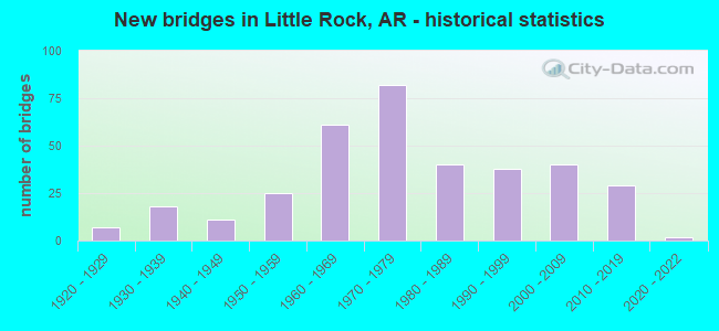
- New bridges - historical statistics
- 71920-1929
- 181930-1939
- 111940-1949
- 251950-1959
- 611960-1969
- 821970-1979
- 401980-1989
- 381990-1999
- 402000-2009
- 292010-2019
- 22020-2022

- Reconstructed bridges - Historical Statistics
- 11950-1959
- 21960-1969
- 201970-1979
- 131980-1989
- 51990-1999
- 22000-2009
- 42010-2019


- Bridge Condition - Deck
- 3.1%Excellent
- 13.0%Very good
- 41.4%Good
- 32.6%Satisfactory
- 9.6%Fair
- 0.4%Poor

- Bridge Condition - Superstructure
- 3.4%Excellent
- 18.8%Very good
- 31.0%Good
- 29.9%Satisfactory
- 14.6%Fair
- 2.3%Poor

- Bridge Condition - Substructure
- 2.3%Excellent
- 16.1%Very good
- 34.9%Good
- 33.3%Satisfactory
- 13.0%Fair
- 0.4%Poor

- Bridge Condition - Channel
- 21.8%Excellent
- 41.1%Very good
- 27.0%Good
- 9.3%Satisfactory
- 0.8%Fair
- 0.4%Poor

- Bridge Condition - Culverts
- 5.4%Excellent
- 20.7%Very good
- 51.1%Good
- 21.7%Satisfactory
- 1.1%Fair
Find on map >> Show street view
Structure Number: 6918, Location: I-30 Sec 23 Log 130.42 (Lat: 34.668581, Lng: -92.383650), Route carried "under" structure: Interstate 30, Structure Length: 0. m, Average Daily Traffic: 44,000 (year 2014), Truck Traffic: 40%, Features Intersected: I-30 Mn Lns & Fr Rds, Facility Carried by Structure: Mablevale Pike
Minimum Vertical Clearance: 5.68m (18.64ft), Kilometerpoint: 209.891, Length of Maximum Span: 0.0m
Find on map >> Show street view
Structure Number: 6918, Location: I-30 Sec 23 Log 130.42 (Lat: 34.668581, Lng: -92.383650), Route carried "under" structure: ServiceInterstate 30, Structure Length: 0. m, Average Daily Traffic: 44,000 (year 2014), Truck Traffic: 40%, Features Intersected: I-30 Mn Lns & Fr Rds, Facility Carried by Structure: Mablevale Pike
Minimum Vertical Clearance: 6.24m (20.47ft), Kilometerpoint: 209.891, Length of Maximum Span: 0.0m
Find on map >> Show street view
Structure Number: 6918, Location: I-30 Sec 23 Log 130.42 (Lat: 34.668581, Lng: -92.383650), Route carried "under" structure: ServiceInterstate 30, Structure Length: 0. m, Average Daily Traffic: 44,000 (year 2014), Truck Traffic: 40%, Features Intersected: I-30 Mn Lns & Fr Rds, Facility Carried by Structure: Mablevale Pike
Minimum Vertical Clearance: 5.53m (18.14ft), Kilometerpoint: 209.891, Length of Maximum Span: 0.0m
Find on map >> Show street view
Structure Number: 6918, Location: I-30 Sec 23 Log 130.42 (Lat: 34.668581, Lng: -92.383650), Route carried "under" structure: Interstate 30, Structure Length: 0. m, Average Daily Traffic: 44,000 (year 2014), Truck Traffic: 40%, Features Intersected: I-30 Mn Lns & Fr Rds, Facility Carried by Structure: Mablevale Pike
Minimum Vertical Clearance: 5.66m (18.57ft), Kilometerpoint: 209.891, Length of Maximum Span: 0.0m
Find on map >> Show street view
Structure Number: 7189, Location: I-630 and Shackleford Rd. (Lat: 34.748469, Lng: -92.393831), Route carried "under" structure: Alternate City street 10562, Structure Length: 0. m, Average Daily Traffic: 20,000 (year 2015), Truck Traffic: 5%, Features Intersected: Financial Parkway U-Turn, Facility Carried by Structure: I-630 Log 7.50
Minimum Vertical Clearance: 5.33m (17.49ft), Kilometerpoint: 0.002, Length of Maximum Span: 0.0m
Find on map >> Show street view
Structure Number: 7189, Location: I-630 and Shackleford Rd. (Lat: 34.748469, Lng: -92.393831), Route carried "under" structure: City street 52340, Structure Length: 0. m, Average Daily Traffic: 20,000 (year 2015), Truck Traffic: 5%, Features Intersected: Shackleford Road, Facility Carried by Structure: I-630 Log 7.50
Minimum Vertical Clearance: 4.95m (16.24ft), Kilometerpoint: 0.595, Length of Maximum Span: 0.0m
Find on map >> Show street view
Structure Number: 719, Location: 6.5 mile north of I- 30 (Lat: 34.752139, Lng: -92.392039), Route carried "under" structure: Interstate 430, Structure Length: 0. m, Average Daily Traffic: 40,000 (year 2015), Truck Traffic: 1%, Features Intersected: I430 NB Lanes (A)
Minimum Vertical Clearance: 5.71m (18.73ft), Kilometerpoint: 10.541, Length of Maximum Span: 0.0m
Find on map >> Show street view
Structure Number: 719, Location: 6.5 mile north of I- 30 (Lat: 34.752139, Lng: -92.392039), Route carried "under" structure: Interstate 430, Structure Length: 0. m, Average Daily Traffic: 40,000 (year 2015), Truck Traffic: 1%, Features Intersected: I 430 SB Lns (B)
Minimum Vertical Clearance: 5.68m (18.64ft), Kilometerpoint: 10.541, Length of Maximum Span: 0.0m
Find on map >> Show street view
Structure Number: 719, Location: 6.5 mile north of I- 30 (Lat: 34.752139, Lng: -92.392039), Route carried "under" structure: Ramp Interstate 630, Structure Length: 0. m, Average Daily Traffic: 40,000 (year 2015), Truck Traffic: 1%, Features Intersected: 430 NB - 630 WB rmp (C)
Minimum Vertical Clearance: 7.62m (25.00ft), Kilometerpoint: 10.541, Length of Maximum Span: 0.0m
Find on map >> Show street view
Structure Number: 719, Location: 6.5 mile north of I- 30 (Lat: 34.752139, Lng: -92.392039), Route carried "under" structure: Ramp Interstate 430, Structure Length: 0. m, Average Daily Traffic: 40,000 (year 2015), Truck Traffic: 1%, Features Intersected: I430 SB Serv. Rd (D)
Minimum Vertical Clearance: 5.68m (18.64ft), Kilometerpoint: 10.541, Length of Maximum Span: 0.0m
Find on map >> Show street view
Structure Number: 719, Location: 6.5 mile north of I- 30 (Lat: 34.752139, Lng: -92.392039), Route carried "under" structure: Ramp Interstate 430, Structure Length: 0. m, Average Daily Traffic: 40,000 (year 2015), Truck Traffic: 1%, Features Intersected: I430 NB Lanes (A)
Minimum Vertical Clearance: 5.35m (17.55ft), Kilometerpoint: 10.541, Length of Maximum Span: 0.0m
Find on map >> Show street view
Structure Number: 719, Location: 6.5 mile north of I- 30 (Lat: 34.752139, Lng: -92.392039), Route carried "under" structure: Interstate 630, Structure Length: 0. m, Average Daily Traffic: 40,000 (year 2015), Truck Traffic: 1%, Features Intersected: I-630 WB Mn Lns (F)
Minimum Vertical Clearance: 6.22m (20.41ft), Kilometerpoint: 11.700, Length of Maximum Span: 0.0m
Find on map >> Show street view
Structure Number: 719, Location: 6.5 mile north of I- 30 (Lat: 34.752139, Lng: -92.392039), Route carried "under" structure: Ramp Interstate 630, Structure Length: 0. m, Average Daily Traffic: 40,000 (year 2015), Truck Traffic: 1%, Features Intersected: I430 NB Lanes (A)
Minimum Vertical Clearance: 8.07m (26.48ft), Kilometerpoint: 10.541, Length of Maximum Span: 0.0m
Find on map >> Show street view
Structure Number: 719, Location: 6.5 mile north of I- 30 (Lat: 34.752139, Lng: -92.392039), Route carried "under" structure: Ramp Interstate 430, Structure Length: 0. m, Average Daily Traffic: 40,000 (year 2015), Truck Traffic: 1%, Features Intersected: 430 SB to 630 WB rmp (H)
Minimum Vertical Clearance: 8.07m (26.48ft), Kilometerpoint: 10.541, Length of Maximum Span: 0.0m
Find on map >> Show street view
Structure Number: 7191, Location: Jct I-430/I-630 (Lat: 34.746600, Lng: -92.390611), Route carried "under" structure: Ramp Interstate 630, Structure Length: 0. m, Average Daily Traffic: 43,000 (year 2014), Truck Traffic: 15%, Features Intersected: I-630 EB to I-430 NB
Minimum Vertical Clearance: 5.18m (16.99ft), Kilometerpoint: 11.748, Length of Maximum Span: 0.0m
Find on map >> Show street view
Structure Number: 7191, Location: Jct I-430/I-630 (Lat: 34.746600, Lng: -92.390611), Route carried "under" structure: Interstate 630, Structure Length: 0. m, Average Daily Traffic: 43,000 (year 2014), Truck Traffic: 15%, Features Intersected: I-630 Log 7.30
Minimum Vertical Clearance: 5.30m (17.39ft), Kilometerpoint: 11.668, Length of Maximum Span: 0.0m
Find on map >> Show street view
Structure Number: 7191, Location: Jct I-430/I-630 (Lat: 34.746600, Lng: -92.390611), Route carried "under" structure: Ramp Interstate 630, Structure Length: 0. m, Average Daily Traffic: 43,000 (year 2014), Truck Traffic: 15%, Features Intersected: I-630 Log 7.30
Minimum Vertical Clearance: 5.76m (18.90ft), Kilometerpoint: 11.668, Length of Maximum Span: 0.0m
Find on map >> Show street view
Structure Number: 7191, Location: Jct I-430/I-630 (Lat: 34.746600, Lng: -92.390611), Route carried "under" structure: Ramp Interstate 630, Structure Length: 0. m, Average Daily Traffic: 43,000 (year 2014), Truck Traffic: 15%, Features Intersected: I-630 EB to I-430 NB
Minimum Vertical Clearance: 9.34m (30.64ft), Kilometerpoint: 11.732, Length of Maximum Span: 0.0m
Find on map >> Show street view
Structure Number: 7192, Location: 7.10 mile west I-30 (Lat: 34.748389, Lng: -92.386561), Route carried "under" structure: Ramp Interstate 630, Structure Length: 0. m, Average Daily Traffic: 7,280 (year 2008), Features Intersected: 630 & 430
Minimum Vertical Clearance: 15.31m (50.23ft), Kilometerpoint: 11.426, Length of Maximum Span: 0.0m
Find on map >> Show street view
Structure Number: 7192, Location: 7.10 mile west I-30 (Lat: 34.748389, Lng: -92.386561), Route carried "under" structure: Ramp Interstate 630, Structure Length: 0. m, Average Daily Traffic: 7,280 (year 2008), Features Intersected: 630 & 430
Minimum Vertical Clearance: 5.33m (17.49ft), Kilometerpoint: 11.426, Length of Maximum Span: 0.0m
Find on map >> Show street view
Structure Number: 7192, Location: 7.10 mile west I-30 (Lat: 34.748389, Lng: -92.386561), Route carried "under" structure: Interstate 630, Structure Length: 0. m, Average Daily Traffic: 7,280 (year 2008), Features Intersected: 630 & 430
Minimum Vertical Clearance: 16.35m (53.64ft), Kilometerpoint: 11.587, Length of Maximum Span: 0.0m
Find on map >> Show street view
Structure Number: 7192, Location: 7.10 mile west I-30 (Lat: 34.748389, Lng: -92.386561), Route carried "under" structure: Interstate 430, Structure Length: 0. m, Average Daily Traffic: 7,280 (year 2008), Features Intersected: 630 & 430
Minimum Vertical Clearance: 5.35m (17.55ft), Kilometerpoint: 10.010, Length of Maximum Span: 0.0m
Find on map >> Show street view
Structure Number: 7192, Location: 7.10 mile west I-30 (Lat: 34.748389, Lng: -92.386561), Route carried "under" structure: Ramp Interstate 430, Structure Length: 0. m, Average Daily Traffic: 7,280 (year 2008), Features Intersected: 630 & 430
Minimum Vertical Clearance: 8.96m (29.40ft), Kilometerpoint: 0.595, Length of Maximum Span: 0.0m
Find on map >> Show street view
Structure Number: 7192, Location: 7.10 mile west I-30 (Lat: 34.748389, Lng: -92.386561), Route carried "under" structure: Interstate 430, Structure Length: 0. m, Average Daily Traffic: 7,280 (year 2008), Features Intersected: 630 & 430
Minimum Vertical Clearance: 5.99m (19.65ft), Kilometerpoint: 10.010, Length of Maximum Span: 0.0m
Find on map >> Show street view
Structure Number: 7193, Location: I-630 Log 6.82 (Lat: 34.747831, Lng: -92.381989), Route carried "under" structure: Interstate 630, Structure Length: 0. m, Average Daily Traffic: 44,000 (year 2014), Truck Traffic: 15%, Features Intersected: I-630 Log 6.82, Facility Carried by Structure: Baptist Health Dr
Minimum Vertical Clearance: 5.46m (17.91ft), Kilometerpoint: 10.976, Length of Maximum Span: 0.0m
Find on map >> Show street view
Structure Number: 7193, Location: I-630 Log 6.82 (Lat: 34.747831, Lng: -92.381989), Route carried "under" structure: Interstate 630, Structure Length: 0. m, Average Daily Traffic: 44,000 (year 2014), Truck Traffic: 15%, Features Intersected: I-630 Log 6.82, Facility Carried by Structure: Baptist Health Dr
Minimum Vertical Clearance: 8.12m (26.64ft), Kilometerpoint: 10.976, Length of Maximum Span: 0.0m
Find on map >> Show street view
Structure Number: 7193, Location: I-630 Log 6.82 (Lat: 34.747831, Lng: -92.381989), Route carried "under" structure: Interstate 630, Structure Length: 0. m, Features Intersected: I-630 Log 6.82, Facility Carried by Structure: Baptist Health Dr
Minimum Vertical Clearance: 8.20m (26.90ft), Kilometerpoint: 10.976, Length of Maximum Span: 0.0m
Find on map >> Show street view
Structure Number: 7284, Location: 1 MI E of Jct Asher Rd (Lat: 34.725050, Lng: -92.302981), Route carried "under" structure: City street 48610, Structure Length: 0. m, Average Daily Traffic: 100 (year 2016), Truck Traffic: 1%, Features Intersected: Rice St, Facility Carried by Structure: US 70/Roosevelt Rd
Minimum Vertical Clearance: 5.18m (16.99ft), Kilometerpoint: 0.161, Length of Maximum Span: 0.0m
Find on map >> Show street view
Structure Number: 7292, Location: ARK RIV-BROADWAYST-US70 (Lat: 34.749725, Lng: -92.274936), Route carried "under" structure: City street 49137, Structure Length: 0. m, Features Intersected: Riverfront Dr, Facility Carried by Structure: US 70-District 6
Minimum Vertical Clearance: 7.08m (23.23ft), Kilometerpoint: 0.789, Length of Maximum Span: 0.0m
Find on map >> Show street view
Structure Number: 7292, Location: ARK RIV-BROADWAYST-US70 (Lat: 34.749725, Lng: -92.274936), Route carried "under" structure: State highway 10, Structure Length: 0. m, Features Intersected: SH 10 La Harpe Blvd, Facility Carried by Structure: US 70-District 6
Minimum Vertical Clearance: 5.33m (17.49ft), Kilometerpoint: 25.186, Length of Maximum Span: 0.0m
Find on map >> Show street view
Structure Number: 7292, Location: ARK RIV-BROADWAYST-US70 (Lat: 34.749725, Lng: -92.274936), Route carried "under" structure: State highway 10, Structure Length: 0. m, Features Intersected: SH 10 La Harpe Blvd, Facility Carried by Structure: US 70-District 6
Minimum Vertical Clearance: 5.15m (16.90ft), Kilometerpoint: 25.186, Length of Maximum Span: 0.0m
Find on map >> Show street view
Structure Number: 7292, Location: ARK RIV-BROADWAYST-US70 (Lat: 34.749725, Lng: -92.274936), Route carried "under" structure: City street 49137, Structure Length: 0. m, Features Intersected: Riverfront Dr, Facility Carried by Structure: US 70-District 6
Minimum Vertical Clearance: 7.33m (24.05ft), Kilometerpoint: 0.789, Length of Maximum Span: 0.0m
Find on map >> Show street view
Structure Number: 7295, Location: So. appr. Brdwy. Br. (Lat: 34.750011, Lng: -92.276031), Route carried "under" structure: City street 1850, Structure Length: 0. m, Average Daily Traffic: 100 (year 2017), Truck Traffic: 1%, Features Intersected: Arch St., Facility Carried by Structure: SH 10 off ramp
Minimum Vertical Clearance: 4.67m (15.32ft), Kilometerpoint: 0.805, Length of Maximum Span: 0.0m
Find on map >> Show street view
Structure Number: 7383, Location: 1.7 E OF I-430 (Lat: 34.745661, Lng: -92.358800), Route carried "under" structure: City street 38940, Structure Length: 0. m, Average Daily Traffic: 9,736 (year 1983), Truck Traffic: 1%, Features Intersected: Miss Ave, Rushing Creek, Facility Carried by Structure: I 630 EB Log 5.48
Minimum Vertical Clearance: 5.02m (16.47ft), Kilometerpoint: 1.271, Length of Maximum Span: 0.0m
Find on map >> Show street view
Structure Number: 7384, Location: 2.4 E mi of I-430 (Lat: 34.745811, Lng: -92.350231), Route carried "under" structure: Interstate 630, Structure Length: 0. m, Average Daily Traffic: 10,700 (year 2014), Truck Traffic: 1%, Features Intersected: I-630 LOG 5.00, Facility Carried by Structure: HUGHES STREET
Minimum Vertical Clearance: 6.30m (20.67ft), Kilometerpoint: 8.045, Length of Maximum Span: 0.0m
Find on map >> Show street view
Structure Number: 7384, Location: 2.4 E mi of I-430 (Lat: 34.745811, Lng: -92.350231), Route carried "under" structure: Interstate 630, Structure Length: 0. m, Average Daily Traffic: 13,345 (year 2014), Truck Traffic: 1%, Features Intersected: I-630 LOG 5.00, Facility Carried by Structure: HUGHES STREET
Minimum Vertical Clearance: 5.36m (17.59ft), Kilometerpoint: 8.045, Length of Maximum Span: 0.0m
Find on map >> Show street view
Structure Number: 7433, Location: .15 M W of Hwy10/I430 (Lat: 34.789972, Lng: -92.392869), Route carried "under" structure: Ramp State highway 10, Structure Length: 0. m, Features Intersected: Ramps 18 and 19, Facility Carried by Structure: ramp
Minimum Vertical Clearance: 5.41m (17.75ft), Kilometerpoint: 12.311, Length of Maximum Span: 0.0m
Find on map >> Show street view
Structure Number: 19355, Location: 1200 E 6TH STREET (Lat: 34.741869, Lng: -92.257619), Route carried "under" structure: City street 64530, Structure Length: 0. m, Average Daily Traffic: 5,985 (year 1983), Truck Traffic: 1%, Features Intersected: EAST 6TH STREET, Facility Carried by Structure: U.P.R.R. E 6th
Minimum Vertical Clearance: 3.78m (12.40ft), Kilometerpoint: 1.287, Length of Maximum Span: 0.0m
Find on map >> Show street view
Structure Number: 19355, Location: 1200 E 6TH STREET (Lat: 34.741869, Lng: -92.257619), Route carried "under" structure: City street 64530, Structure Length: 0. m, Average Daily Traffic: 5,985 (year 1983), Truck Traffic: 1%, Features Intersected: EAST 6TH STREET, Facility Carried by Structure: U.P.R.R. E 6th
Minimum Vertical Clearance: 3.77m (12.37ft), Kilometerpoint: 1.287, Length of Maximum Span: 0.0m
Find on map >> Show street view
Structure Number: 19356, Location: E 6TH & PEPPER AVE (Lat: 34.742000, Lng: -92.252769), Route carried "under" structure: City street 64530, Structure Length: 0. m, Average Daily Traffic: 5,985 (year 1983), Truck Traffic: 1%, Features Intersected: EAST 6TH STREET, Facility Carried by Structure: UPRR & 6th Str.
Minimum Vertical Clearance: 4.11m (13.48ft), Kilometerpoint: 1.754, Length of Maximum Span: 0.0m
Find on map >> Show street view
Structure Number: 19358, Location: E. of Woodrow /N of I-630 (Lat: 34.744981, Lng: -92.300811), Route carried "under" structure: City street 64550, Structure Length: 0. m, Average Daily Traffic: 3,593 (year 1983), Truck Traffic: 1%, Features Intersected: WEST 7TH STREET, Facility Carried by Structure: U.P.R.R.
Minimum Vertical Clearance: 4.19m (13.75ft), Kilometerpoint: 2.688, Length of Maximum Span: 0.0m
Find on map >> Show street view
Structure Number: 19359, Location: E. of Woodrow /N of I-630 (Lat: 34.745036, Lng: -92.300378), Route carried "under" structure: City street 64550, Structure Length: 0. m, Average Daily Traffic: 3,593 (year 1983), Truck Traffic: 1%, Features Intersected: WEST 7TH STREET, Facility Carried by Structure: U.P.R.R. Abandoned
Minimum Vertical Clearance: 4.14m (13.58ft), Kilometerpoint: 2.734, Length of Maximum Span: 0.0m
Find on map >> Show street view
Structure Number: 19383, Location: INTCH OF SUMMIT&11 ST (Lat: 34.740689, Lng: -92.295139), Route carried "under" structure: City street 56200, Structure Length: 0. m, Average Daily Traffic: 470 (year 1983), Truck Traffic: 1%, Features Intersected: SO SUMMIT ST, Facility Carried by Structure: W 11 STREET
Minimum Vertical Clearance: 3.42m (11.22ft), Kilometerpoint: 1.127, Length of Maximum Span: 0.0m
Find on map >> Show street view
Structure Number: 20628, Location: EAST OF US 70 (Lat: 34.749569, Lng: -92.272919), Route carried "under" structure: State highway 10, Structure Length: 0. m, Average Daily Traffic: 18,000 (year 2014), Truck Traffic: 1%, Features Intersected: SH 10 SEC 8 E & W B LANE, Facility Carried by Structure: DOUBLETREE PED.W'W
Minimum Vertical Clearance: 4.81m (15.78ft), Kilometerpoint: 25.391, Length of Maximum Span: 0.0m
Find on map >> Show street view
Structure Number: 20629, Location: East of Jct US 70 & SH 10 (Lat: 34.749319, Lng: -92.271581), Route carried "under" structure: State highway 10, Structure Length: 0. m, Average Daily Traffic: 9,000 (year 2014), Truck Traffic: 1%, Features Intersected: SH 10-SEC 8, Facility Carried by Structure: Marriott Hotel
Minimum Vertical Clearance: 5.15m (16.90ft), Kilometerpoint: 25.584, Length of Maximum Span: 0.0m
Find on map >> Show street view
Structure Number: 20629, Location: East of Jct US 70 & SH 10 (Lat: 34.749319, Lng: -92.271581), Route carried "under" structure: State highway 10, Structure Length: 0. m, Average Daily Traffic: 9,000 (year 2014), Truck Traffic: 1%, Features Intersected: SH 10-SEC 8, Facility Carried by Structure: Marriott Hotel
Minimum Vertical Clearance: 5.18m (16.99ft), Kilometerpoint: 25.584, Length of Maximum Span: 0.0m
Find on map >> Show street view
Structure Number: 21782, Location: 0.70 MILE N OF ROOSEVELT (Lat: 34.730278, Lng: -92.217222), Route carried "under" structure: City street 540, Structure Length: 0. m, Average Daily Traffic: 100 (year 1996), Features Intersected: AIRPORT ROAD, Facility Carried by Structure: TAXIWAY 'T' & 'U'
Minimum Vertical Clearance: 4.81m (15.78ft), Kilometerpoint: 1.127, Length of Maximum Span: 0.0m
Find on map >> Show street view
Structure Number: 22487, Location: 0.4 M So. Co. Rd. 38 (Lat: 34.774961, Lng: -92.563139), Route carried "under" structure: 41, Structure Length: 0. m, Features Intersected: Private Drive
Minimum Vertical Clearance: 5.02m (16.47ft), Length of Maximum Span: 0.0m
Structure Number: 22487, Location: 0.4 M So. Co. Rd. 38 (Lat: 34.774961, Lng: -92.563139), Route carried "under" structure: 41, Structure Length: 0. m, Features Intersected: Private Drive
Minimum Vertical Clearance: 5.02m (16.47ft), Length of Maximum Span: 0.0m
Find on map >> Show street view
Structure Number: 23122, Location: 0.10 M So. Markham (Lat: 34.750419, Lng: -92.321311), Route carried "under" structure: State lands road 841, Structure Length: 0. m, Average Daily Traffic: 1,000 (year 2008), Truck Traffic: 1%, Features Intersected: Hooper Street, Facility Carried by Structure: UAMS Pedstr. Brg
Minimum Vertical Clearance: 4.24m (13.91ft), Kilometerpoint: 2.543, Length of Maximum Span: 0.0m
Find on map >> Show street view
Structure Number: 23122, Location: 0.10 M So. Markham (Lat: 34.750419, Lng: -92.321311), Route carried "under" structure: State lands road 841, Structure Length: 0. m, Average Daily Traffic: 1,000 (year 2008), Truck Traffic: 1%, Features Intersected: Hooper Street, Facility Carried by Structure: UAMS Pedstr. Brg
Minimum Vertical Clearance: 4.41m (14.47ft), Kilometerpoint: 2.543, Length of Maximum Span: 0.0m
Find on map >> Show street view
Structure Number: 23464, Location: Between UAMS and VA hosp (Lat: 34.747189, Lng: -92.320539), Route carried "under" structure: State lands road 841, Structure Length: 0. m, Average Daily Traffic: 500 (year 2011), Truck Traffic: 1%, Features Intersected: Shuffield Dr./SH841, Facility Carried by Structure: Pedestrian Bridge
Minimum Vertical Clearance: 7.82m (25.66ft), Kilometerpoint: 0.869, Length of Maximum Span: 0.0m
Find on map >> Show street view
Structure Number: 23465, Location: 0.005 M. East Hooper Dr. (Lat: 34.749561, Lng: -92.320950), Route carried "under" structure: State lands road 841, Structure Length: 0. m, Average Daily Traffic: 50 (year 2011), Truck Traffic: 1%, Features Intersected: Bridge Drive/SH841, Facility Carried by Structure: Pedestrian Bridge
Minimum Vertical Clearance: 10.82m (35.50ft), Kilometerpoint: 3.508, Length of Maximum Span: 0.0m
Find on map >> Show street view
Structure Number: 23491, Location: 0.12 M N Hooper Drive (Lat: 34.750411, Lng: -92.320569), Route carried "under" structure: State lands road 841, Structure Length: 0. m, Average Daily Traffic: 50 (year 2011), Truck Traffic: 1%, Features Intersected: Bridge Drive/SH841, Facility Carried by Structure: Pedestrian Bridge
Minimum Vertical Clearance: 4.34m (14.24ft), Kilometerpoint: 3.637, Length of Maximum Span: 0.0m
Find on map >> Show street view
Structure Number: A1538, Location: 1.21 MI W & US 70 (Lat: 34.754611, Lng: -92.295061), Route carried "under" structure: City street 22350, Structure Length: 0. m, Average Daily Traffic: 108 (year 1983), Truck Traffic: 1%, Features Intersected: Gill St/RR/Rose Bayou, Facility Carried by Structure: SH 10-SEC 8, WB LN
Minimum Vertical Clearance: 8.17m (26.80ft), Kilometerpoint: 0.306, Length of Maximum Span: 0.0m
Find on map >> Show street view
Structure Number: A1538, Location: 1.21 MI W & US 70 (Lat: 34.754611, Lng: -92.295061), Route carried "under" structure: City street 22350, Structure Length: 0. m, Average Daily Traffic: 108 (year 1983), Truck Traffic: 1%, Features Intersected: Gill St/RR/Rose Bayou, Facility Carried by Structure: SH 10-SEC 8, WB LN
Minimum Vertical Clearance: 5.25m (17.22ft), Kilometerpoint: 0.306, Length of Maximum Span: 0.0m
Find on map >> Show street view
Structure Number: A3173, Location: 0.5 MI E OF US 70 (Lat: 34.679000, Lng: -92.344081), Route carried "under" structure: City street 22260, Structure Length: 0. m, Average Daily Traffic: 27,132 (year 1983), Truck Traffic: 1%, Features Intersected: GEYER SPRINGS ROAD, Facility Carried by Structure: I -30 WB 132.81
Minimum Vertical Clearance: 4.41m (14.47ft), Kilometerpoint: 1.078, Length of Maximum Span: 0.0m
Find on map >> Show street view
Structure Number: A3176, Location: 3.1 MI EAST OF SH 70 (Lat: 34.688900, Lng: -92.306081), Route carried "under" structure: City street 65170, Structure Length: 0. m, Average Daily Traffic: 6,262 (year 1983), Truck Traffic: 1%, Features Intersected: 65TH STREET, Facility Carried by Structure: I-30 WB Log 135.28
Minimum Vertical Clearance: 4.47m (14.67ft), Kilometerpoint: 37.972, Length of Maximum Span: 0.0m
Find on map >> Show street view
Structure Number: A3179, Location: 1 MI S OF SH 365 (Lat: 34.706550, Lng: -92.288111), Route carried "under" structure: State highway 367, Structure Length: 0. m, Average Daily Traffic: 6,700 (year 2014), Truck Traffic: 1%, Features Intersected: SH 367, RR, CREEK, Facility Carried by Structure: I-30 WB Log 136.90
Minimum Vertical Clearance: 4.29m (14.07ft), Kilometerpoint: 15.446, Length of Maximum Span: 0.0m
Find on map >> Show street view
Structure Number: A3329, Location: 2.5 MI S I- 30 (Lat: 34.672750, Lng: -92.266000), Route carried "under" structure: State highway 338, Structure Length: 0. m, Average Daily Traffic: 10,000 (year 2014), Truck Traffic: 1%, Features Intersected: SH 338-SEC 2, Facility Carried by Structure: I 530 SB Log 2.84
Minimum Vertical Clearance: 4.60m (15.09ft), Kilometerpoint: 4.780, Length of Maximum Span: 0.0m
Find on map >> Show street view
Structure Number: A3335, Location: BIDDLE S .6 M S 365 (Lat: 34.715411, Lng: -92.269769), Route carried "under" structure: ServiceInterstate 30, Structure Length: 0. m, Average Daily Traffic: 94,000 (year 2013), Truck Traffic: 1%, Features Intersected: FRONTAGE RD & U.P.R.R.
Minimum Vertical Clearance: 8.86m (29.07ft), Kilometerpoint: 222.830, Length of Maximum Span: 0.0m
Find on map >> Show street view
Structure Number: A3395, Location: 4.6 MI N OF SH 338 (Lat: 34.723761, Lng: -92.267150), Route carried "under" structure: State highway 365, Structure Length: 0. m, Average Daily Traffic: 6,500 (year 2014), Truck Traffic: 1%, Features Intersected: SH 365-SEC 12, Facility Carried by Structure: I 30-WB log 138.90
Minimum Vertical Clearance: 4.41m (14.47ft), Kilometerpoint: 1.127, Length of Maximum Span: 0.0m
Find on map >> Show street view
Structure Number: A3395, Location: 4.6 MI N OF SH 338 (Lat: 34.723761, Lng: -92.267150), Route carried "under" structure: State highway 365, Structure Length: 0. m, Average Daily Traffic: 6,500 (year 2014), Truck Traffic: 1%, Features Intersected: SH 365-SEC 12, Facility Carried by Structure: I 30-WB log 138.90
Minimum Vertical Clearance: 4.26m (13.98ft), Kilometerpoint: 1.127, Length of Maximum Span: 0.0m
Find on map >> Show street view
Structure Number: A3397, Location: 5.2 MI NO OF SH 338 (Lat: 34.731169, Lng: -92.262989), Route carried "under" structure: City street 64553, Structure Length: 0. m, Average Daily Traffic: 2,793 (year 1983), Truck Traffic: 1%, Features Intersected: EAST 17TH STREET, Facility Carried by Structure: I 30-SEC 23 EB & W
Minimum Vertical Clearance: 4.38m (14.37ft), Kilometerpoint: 0.998, Length of Maximum Span: 0.0m
Find on map >> Show street view
Structure Number: A3493, Location: 4.69 MI W JCT I 30 (Lat: 34.745022, Lng: -92.341147), Route carried "under" structure: City street 59020, Structure Length: 0. m, Average Daily Traffic: 26,460 (year 1983), Truck Traffic: 1%, Features Intersected: UNIVERSITY AVE, Facility Carried by Structure: I 630 WB Log 4.48
Minimum Vertical Clearance: 4.41m (14.47ft), Kilometerpoint: 8.369, Length of Maximum Span: 0.0m
Find on map >> Show street view
Structure Number: A3493, Location: 4.69 MI W JCT I 30 (Lat: 34.745022, Lng: -92.341147), Route carried "under" structure: City street 59020, Structure Length: 0. m, Average Daily Traffic: 26,460 (year 1983), Truck Traffic: 1%, Features Intersected: UNIVERSITY AVE, Facility Carried by Structure: I 630 WB Log 4.48
Minimum Vertical Clearance: 4.32m (14.17ft), Kilometerpoint: 8.369, Length of Maximum Span: 0.0m
Find on map >> Show street view
Structure Number: A3498, Location: 5.47 M E I-430 (Lat: 34.743719, Lng: -92.299661), Route carried "under" structure: City street 57520, Structure Length: 0. m, Average Daily Traffic: 217 (year 1983), Truck Traffic: 1%, Features Intersected: Thayer Street, Facility Carried by Structure: I-630 WB Log 2.10
Minimum Vertical Clearance: 10.91m (35.79ft), Kilometerpoint: 0.853, Length of Maximum Span: 0.0m
Find on map >> Show street view
Structure Number: A3498, Location: 5.47 M E I-430 (Lat: 34.743719, Lng: -92.299661), Route carried "under" structure: City street 48610, Structure Length: 0. m, Average Daily Traffic: 101 (year 1983), Truck Traffic: 1%, Features Intersected: Rice Street, Facility Carried by Structure: I-630 WB Log 2.10
Minimum Vertical Clearance: 7.68m (25.20ft), Kilometerpoint: 0.772, Length of Maximum Span: 0.0m
Find on map >> Show street view
Structure Number: A3499, Location: 2.2 MI W OF JCT I-30 (Lat: 34.743939, Lng: -92.297219), Route carried "under" structure: City street 43930, Structure Length: 0. m, Average Daily Traffic: 500 (year 2001), Truck Traffic: 1%, Features Intersected: PARK STREET, Facility Carried by Structure: I-630 WB log 1.96
Minimum Vertical Clearance: 6.37m (20.90ft), Kilometerpoint: 0.724, Length of Maximum Span: 0.0m
Find on map >> Show street view
Structure Number: A5306, Location: 0.6 MI E OF SH 5 (Lat: 34.670669, Lng: -92.406250), Route carried "under" structure: State highway 338, Structure Length: 0. m, Average Daily Traffic: 9,700 (year 2014), Truck Traffic: 1%, Features Intersected: SH 338-SEC 1, Facility Carried by Structure: I 430 NB Log 0.65
Minimum Vertical Clearance: 4.52m (14.83ft), Kilometerpoint: 1.062, Length of Maximum Span: 0.0m
Find on map >> Show street view
Structure Number: A531, Location: 1.5 MI W OF SH 5 (Lat: 34.712400, Lng: -92.401672), Route carried "under" structure: State highway 300, Structure Length: 0. m, Average Daily Traffic: 8,000 (year 2014), Truck Traffic: 1%, Features Intersected: SH 300-SEC 3, Facility Carried by Structure: I 430 NB Log 3.56
Minimum Vertical Clearance: 4.96m (16.27ft), Kilometerpoint: 2.285, Length of Maximum Span: 0.0m
Find on map >> Show street view
Structure Number: A531, Location: 1.5 MI W OF SH 5 (Lat: 34.712400, Lng: -92.401672), Route carried "under" structure: State highway 300, Structure Length: 0. m, Average Daily Traffic: 8,000 (year 2014), Truck Traffic: 1%, Features Intersected: SH 300-SEC 3, Facility Carried by Structure: I 430 NB Log 3.56
Minimum Vertical Clearance: 4.69m (15.39ft), Kilometerpoint: 2.285, Length of Maximum Span: 0.0m
Find on map >> Show street view
Structure Number: A5311, Location: .6 MI N JCT SH 300 (Lat: 34.720958, Lng: -92.401139), Route carried "under" structure: City street 64880, Structure Length: 0. m, Average Daily Traffic: 152 (year 1983), Truck Traffic: 1%, Features Intersected: 36TH ST, BRODIE CREEK, Facility Carried by Structure: I-430 NB Log 4.15
Minimum Vertical Clearance: 6.12m (20.08ft), Kilometerpoint: 0.644, Length of Maximum Span: 0.0m
Find on map >> Show street view
Structure Number: A5316, Location: 1.02 M N I-630 (Lat: 34.763261, Lng: -92.390631), Route carried "under" structure: City street 6700, Structure Length: 0. m, Average Daily Traffic: 2,370 (year 1983), Truck Traffic: 1%, Features Intersected: BRECKENRIDGE DRIVE, Facility Carried by Structure: I 430 NB Log 7.32
Minimum Vertical Clearance: 4.47m (14.67ft), Kilometerpoint: 0.016, Length of Maximum Span: 0.0m
Find on map >> Show street view
Structure Number: A5317, Location: JCT 430 & RODNEY PARHAM (Lat: 34.768331, Lng: -92.389831), Route carried "under" structure: Interstate 430, Structure Length: 0. m, Average Daily Traffic: 40,000 (year 2014), Truck Traffic: 1%, Features Intersected: I 430-LOG 7.69, Facility Carried by Structure: RODNEY PARHAM WB
Minimum Vertical Clearance: 5.05m (16.57ft), Kilometerpoint: 12.373, Length of Maximum Span: 0.0m
Find on map >> Show street view
Structure Number: A5317, Location: JCT 430 & RODNEY PARHAM (Lat: 34.768331, Lng: -92.389831), Route carried "under" structure: Interstate 430, Structure Length: 0. m, Average Daily Traffic: 40,000 (year 2014), Truck Traffic: 1%, Features Intersected: I 430-LOG 7.69, Facility Carried by Structure: RODNEY PARHAM WB
Minimum Vertical Clearance: 5.38m (17.65ft), Kilometerpoint: 12.373, Length of Maximum Span: 0.0m
Find on map >> Show street view
Structure Number: A5318, Location: .51 MI S JCT SH 10 (Lat: 34.780964, Lng: -92.390647), Route carried "under" structure: City street 45840, Structure Length: 0. m, Average Daily Traffic: 1,605 (year 1983), Truck Traffic: 1%, Features Intersected: PLEASANT VALLEY DR, Facility Carried by Structure: I 430-Log 8.54 NB
Minimum Vertical Clearance: 7.84m (25.72ft), Kilometerpoint: 0.869, Length of Maximum Span: 0.0m
Find on map >> Show street view
Structure Number: A5318, Location: .51 MI S JCT SH 10 (Lat: 34.780964, Lng: -92.390647), Route carried "under" structure: City street 45840, Structure Length: 0. m, Average Daily Traffic: 3,210 (year 1983), Truck Traffic: 1%, Features Intersected: PLEASANT VALLEY DR, Facility Carried by Structure: I 430-Log 8.54 NB
Minimum Vertical Clearance: 9.19m (30.15ft), Kilometerpoint: 0.869, Length of Maximum Span: 0.0m
Find on map >> Show street view
Structure Number: A5319, Location: @ JCT SH 10 & I 430 (Lat: 34.788400, Lng: -92.391519), Route carried "under" structure: ServiceInterstate 430, Structure Length: 0. m, Average Daily Traffic: 43,500 (year 2014), Truck Traffic: 1%, Features Intersected: I 430 Log 9.05, Facility Carried by Structure: SH 10 EB Log 7.97
Minimum Vertical Clearance: 5.02m (16.47ft), Kilometerpoint: 14.561, Length of Maximum Span: 0.0m
Find on map >> Show street view
Structure Number: A5319, Location: @ JCT SH 10 & I 430 (Lat: 34.788400, Lng: -92.391519), Route carried "under" structure: Interstate 430, Structure Length: 0. m, Average Daily Traffic: 43,500 (year 2014), Truck Traffic: 1%, Features Intersected: I 430 Log 9.05, Facility Carried by Structure: SH 10 EB Log 7.97
Minimum Vertical Clearance: 6.30m (20.67ft), Kilometerpoint: 14.561, Length of Maximum Span: 0.0m
Find on map >> Show street view
Structure Number: A5319, Location: @ JCT SH 10 & I 430 (Lat: 34.788400, Lng: -92.391519), Route carried "under" structure: Interstate 430, Structure Length: 0. m, Average Daily Traffic: 43,500 (year 2014), Truck Traffic: 1%, Features Intersected: I 430 Log 9.05, Facility Carried by Structure: SH 10 EB Log 7.97
Minimum Vertical Clearance: 5.24m (17.19ft), Kilometerpoint: 14.561, Length of Maximum Span: 0.0m
Find on map >> Show street view
Structure Number: A57, Location: SO TERMINAL-EW RAMP (Lat: 34.712339, Lng: -92.272250), Route carried "under" structure: Interstate 30, Structure Length: 0. m, Average Daily Traffic: 45,500 (year 2014), Truck Traffic: 1%, Features Intersected: I-30, Facility Carried by Structure: I 440-SEC 1 WB
Minimum Vertical Clearance: 5.82m (19.09ft), Kilometerpoint: 222.310, Length of Maximum Span: 0.0m
Find on map >> Show street view
Structure Number: A57, Location: SO TERMINAL-EW RAMP (Lat: 34.712339, Lng: -92.272250), Route carried "under" structure: Interstate 30, Structure Length: 0. m, Average Daily Traffic: 45,500 (year 2014), Truck Traffic: 1%, Features Intersected: I-30, Facility Carried by Structure: I 440-SEC 1 WB
Minimum Vertical Clearance: 6.15m (20.18ft), Kilometerpoint: 222.204, Length of Maximum Span: 0.0m
Find on map >> Show street view
Structure Number: A57, Location: SO TERMINAL-EW RAMP (Lat: 34.712339, Lng: -92.272250), Route carried "under" structure: State highway 365, Structure Length: 0. m, Average Daily Traffic: 5,400 (year 2014), Truck Traffic: 1%, Features Intersected: Springer Blvd, Facility Carried by Structure: I 440-SEC 1 WB
Minimum Vertical Clearance: 5.09m (16.70ft), Kilometerpoint: 2.803, Length of Maximum Span: 0.0m
Find on map >> Show street view
Structure Number: A57, Location: SO TERMINAL-EW RAMP (Lat: 34.712339, Lng: -92.272250), Route carried "under" structure: City street , Structure Length: 0. m, Average Daily Traffic: 6,710 (year 1984), Truck Traffic: 1%, Features Intersected: Frazier Pike, Facility Carried by Structure: I 440-SEC 1 WB
Minimum Vertical Clearance: 8.22m (26.97ft), Kilometerpoint: 0.000, Length of Maximum Span: 0.0m
Find on map >> Show street view
Structure Number: A5703, Location: 3.7 MI E OF US 65 (Lat: 34.716939, Lng: -92.213189), Route carried "under" structure: City street 33560, Structure Length: 0. m, Average Daily Traffic: 1,600 (year 1983), Truck Traffic: 1%, Features Intersected: LINDSEY ROAD, Facility Carried by Structure: I 440 WB Log 3.92
Minimum Vertical Clearance: 5.89m (19.32ft), Kilometerpoint: 0.515, Length of Maximum Span: 0.0m
Find on map >> Show street view
Structure Number: A5704, Location: .2MI NO OF LINDSEY RD (Lat: 34.716189, Lng: -92.189739), Route carried "under" structure: City street 447, Structure Length: 0. m, Average Daily Traffic: 1,605 (year 1983), Truck Traffic: 1%, Features Intersected: FOURCHE DAM PIKE, Facility Carried by Structure: I-440 Log 5.16 WB
Minimum Vertical Clearance: 5.08m (16.67ft), Kilometerpoint: 1.819, Length of Maximum Span: 0.0m
Find on map >> Show street view
Structure Number: A6919, Location: I-30, Sec 23, Log 130.62g (Lat: 34.670153, Lng: -92.380914), Route carried "under" structure: State highway 338, Structure Length: 0. m, Average Daily Traffic: 11,000 (year 2014), Truck Traffic: 1%, Features Intersected: SH 338/Baseline Rd., Facility Carried by Structure: I-30 WB Log 130.62
Minimum Vertical Clearance: 5.15m (16.90ft), Kilometerpoint: 3.396, Length of Maximum Span: 0.0m
Find on map >> Show street view
Structure Number: A692, Location: 2 M NE Jct SH338 (Lat: 34.678911, Lng: -92.354750), Route carried "under" structure: ServiceInterstate 30, Structure Length: 0. m, Average Daily Traffic: 83,000 (year 2014), Truck Traffic: 1%, Features Intersected: US 70, U.P.R.R.,Fr.Rd.
Minimum Vertical Clearance: 8.45m (27.72ft), Kilometerpoint: 212.739, Length of Maximum Span: 0.0m
Find on map >> Show street view
Structure Number: A692, Location: 2 M NE Jct SH338 (Lat: 34.678911, Lng: -92.354750), Route carried "under" structure: US 70, Structure Length: 0. m, Average Daily Traffic: 10,000 (year 2014), Truck Traffic: 1%, Features Intersected: US 70, U.P.R.R.,Fr.Rd., Facility Carried by Structure: I-30 EB Log 132.19
Minimum Vertical Clearance: 5.43m (17.81ft), Kilometerpoint: 0.241, Length of Maximum Span: 0.0m
Find on map >> Show street view
Structure Number: A692, Location: 2 M NE Jct SH338 (Lat: 34.678911, Lng: -92.354750), Route carried "under" structure: US 70, Structure Length: 0. m, Average Daily Traffic: 10,000 (year 2014), Truck Traffic: 1%, Features Intersected: US 70, U.P.R.R.,Fr.Rd., Facility Carried by Structure: I-30 EB Log 132.19
Minimum Vertical Clearance: 5.45m (17.88ft), Kilometerpoint: 0.241, Length of Maximum Span: 0.0m
Find on map >> Show street view
Structure Number: A7141, Location: .1 MI SO Markham St (Lat: 34.747911, Lng: -92.391311), Route carried "under" structure: Interstate 630, Structure Length: 0. m, Average Daily Traffic: 43,000 (year 2014), Truck Traffic: 15%, Features Intersected: I-630 Log 7.40 W.B. M.L., Facility Carried by Structure: I-430 NB Log 6.27
Minimum Vertical Clearance: 5.33m (17.49ft), Kilometerpoint: 11.909, Length of Maximum Span: 0.0m
Find on map >> Show street view
Structure Number: A7141, Location: .1 MI SO Markham St (Lat: 34.747911, Lng: -92.391311), Route carried "under" structure: Ramp Interstate 630, Structure Length: 0. m, Average Daily Traffic: 43,000 (year 2014), Truck Traffic: 15%, Features Intersected: I-630 Log 7.40 W.B. M.L., Facility Carried by Structure: I-430 NB Log 6.27
Minimum Vertical Clearance: 6.18m (20.28ft), Kilometerpoint: 11.909, Length of Maximum Span: 0.0m
Find on map >> Show street view
Structure Number: A7141, Location: .1 MI SO Markham St (Lat: 34.747911, Lng: -92.391311), Route carried "under" structure: Ramp Interstate 630, Structure Length: 0. m, Average Daily Traffic: 43,000 (year 2014), Truck Traffic: 15%, Features Intersected: I-630 Log 7.40 W.B. M.L., Facility Carried by Structure: I-430 NB Log 6.27
Minimum Vertical Clearance: 5.20m (17.06ft), Kilometerpoint: 11.909, Length of Maximum Span: 0.0m
Find on map >> Show street view
Structure Number: A7141, Location: .1 MI SO Markham St (Lat: 34.747911, Lng: -92.391311), Route carried "under" structure: Interstate 630, Structure Length: 0. m, Average Daily Traffic: 43,000 (year 2014), Truck Traffic: 15%, Features Intersected: I-630 Log 7.40 W.B. M.L., Facility Carried by Structure: I-430 NB Log 6.27
Minimum Vertical Clearance: 5.57m (18.27ft), Kilometerpoint: 11.909, Length of Maximum Span: 0.0m
Find on map >> Show street view
Structure Number: B3329, Location: 2.5 MI S JCT I 30 (Lat: 34.672739, Lng: -92.265700), Route carried "under" structure: State highway 338, Structure Length: 0. m, Average Daily Traffic: 4,500 (year 2014), Truck Traffic: 1%, Features Intersected: SH 338-SEC 2, Facility Carried by Structure: I 530 NB Log 2.85
Minimum Vertical Clearance: 4.49m (14.73ft), Kilometerpoint: 4.812, Length of Maximum Span: 0.0m
Find on map >> Show street view
Structure Number: B3335, Location: 0.6 MI S OF SH 365 (Lat: 34.715439, Lng: -92.269581), Route carried "under" structure: ServiceInterstate 30, Structure Length: 0. m, Average Daily Traffic: 94,000 (year 2013), Truck Traffic: 1%, Features Intersected: FRONTAGE RD & U.P.R.R.
Minimum Vertical Clearance: 8.86m (29.07ft), Kilometerpoint: 222.878, Length of Maximum Span: 0.0m
Find on map >> Show street view
Structure Number: B3395, Location: 4.6 MI N JCT SH 338 (Lat: 34.723750, Lng: -92.266919), Route carried "under" structure: State highway 365, Structure Length: 0. m, Average Daily Traffic: 6,500 (year 2014), Truck Traffic: 1%, Features Intersected: SH 365-SEC 12, Facility Carried by Structure: I 30-EB log 138.90
Minimum Vertical Clearance: 4.72m (15.49ft), Kilometerpoint: 1.110, Length of Maximum Span: 0.0m
Find on map >> Show street view
Structure Number: B3493, Location: 4.69 MI W JCT I 30 (Lat: 34.744819, Lng: -92.341161), Route carried "under" structure: City street 59020, Structure Length: 0. m, Average Daily Traffic: 26,460 (year 1983), Truck Traffic: 1%, Features Intersected: UNIVERSITY AVE, Facility Carried by Structure: I 630 EB Log 4.48
Minimum Vertical Clearance: 5.54m (18.18ft), Kilometerpoint: 8.369, Length of Maximum Span: 0.0m
Find on map >> Show street view
Structure Number: B3493, Location: 4.69 MI W JCT I 30 (Lat: 34.744819, Lng: -92.341161), Route carried "under" structure: City street 59020, Structure Length: 0. m, Average Daily Traffic: 26,460 (year 1983), Truck Traffic: 1%, Features Intersected: UNIVERSITY AVE, Facility Carried by Structure: I 630 EB Log 4.48
Minimum Vertical Clearance: 5.53m (18.14ft), Kilometerpoint: 8.369, Length of Maximum Span: 0.0m
Find on map >> Show street view
Structure Number: B3498, Location: 5.47 M E OF I-430 (Lat: 34.743561, Lng: -92.299669), Route carried "under" structure: City street 48610, Structure Length: 0. m, Average Daily Traffic: 217 (year 1983), Truck Traffic: 1%, Features Intersected: Rice Street, Facility Carried by Structure: I-630 EB Log 2.10
Minimum Vertical Clearance: 7.26m (23.82ft), Kilometerpoint: 0.789, Length of Maximum Span: 0.0m
Find on map >> Show street view
Structure Number: B3498, Location: 5.47 M E OF I-430 (Lat: 34.743561, Lng: -92.299669), Route carried "under" structure: City street 57520, Structure Length: 0. m, Average Daily Traffic: 217 (year 1983), Truck Traffic: 1%, Features Intersected: Thayer Street, Facility Carried by Structure: I-630 EB Log 2.10
Minimum Vertical Clearance: 10.82m (35.50ft), Kilometerpoint: 0.837, Length of Maximum Span: 0.0m
Find on map >> Show street view
Structure Number: B3499, Location: 2.2 MI W OF JCT I-30 (Lat: 34.743761, Lng: -92.297211), Route carried "under" structure: City street 43930, Structure Length: 0. m, Average Daily Traffic: 500 (year 2001), Truck Traffic: 1%, Features Intersected: PARK STREET, Facility Carried by Structure: I-630 EB Log 1.96
Minimum Vertical Clearance: 5.73m (18.80ft), Kilometerpoint: 0.740, Length of Maximum Span: 0.0m
Find on map >> Show street view
Structure Number: B5306, Location: 0.6 MI E OF SH 5 (Lat: 34.670669, Lng: -92.406550), Route carried "under" structure: State highway 338, Structure Length: 0. m, Average Daily Traffic: 9,700 (year 2014), Truck Traffic: 1%, Features Intersected: SH 338-SEC 1, Facility Carried by Structure: I 430 SB Log 0.65
Minimum Vertical Clearance: 5.33m (17.49ft), Kilometerpoint: 1.030, Length of Maximum Span: 0.0m
Find on map >> Show street view
Structure Number: B531, Location: 1.5 MI W OF SH 5 (Lat: 34.712400, Lng: -92.401931), Route carried "under" structure: State highway 300, Structure Length: 0. m, Average Daily Traffic: 8,000 (year 2014), Truck Traffic: 1%, Features Intersected: SH 300-SEC 3, Facility Carried by Structure: I-430 SB Log 3.56
Minimum Vertical Clearance: 4.41m (14.47ft), Kilometerpoint: 2.301, Length of Maximum Span: 0.0m
Find on map >> Show street view
Structure Number: B531, Location: 1.5 MI W OF SH 5 (Lat: 34.712400, Lng: -92.401931), Route carried "under" structure: State highway 300, Structure Length: 0. m, Average Daily Traffic: 8,000 (year 2014), Truck Traffic: 1%, Features Intersected: SH 300-SEC 3, Facility Carried by Structure: I-430 SB Log 3.56
Minimum Vertical Clearance: 4.78m (15.68ft), Kilometerpoint: 2.301, Length of Maximum Span: 0.0m
Find on map >> Show street view
Structure Number: B5311, Location: .6MI NO JCT SH 300 (Lat: 34.720975, Lng: -92.401397), Route carried "under" structure: City street 64880, Structure Length: 0. m, Average Daily Traffic: 152 (year 1983), Truck Traffic: 1%, Features Intersected: 36TH ST, BRODIE CREEK, Facility Carried by Structure: I 430 SB Log 4.15
Minimum Vertical Clearance: 4.90m (16.08ft), Kilometerpoint: 0.628, Length of Maximum Span: 0.0m
Find on map >> Show street view
Structure Number: B5316, Location: 1.02 M N OF I-630 (Lat: 34.763281, Lng: -92.390919), Route carried "under" structure: City street 6700, Structure Length: 0. m, Average Daily Traffic: 2,370 (year 1983), Truck Traffic: 1%, Features Intersected: BRECKENRIDGE DR., Facility Carried by Structure: I 430 SB Log 7.32
Minimum Vertical Clearance: 4.81m (15.78ft), Kilometerpoint: 0.032, Length of Maximum Span: 0.0m
Find on map >> Show street view
Structure Number: B5317, Location: 137 M N OF 630 (Lat: 34.768100, Lng: -92.389850), Route carried "under" structure: Interstate 430, Structure Length: 0. m, Average Daily Traffic: 42,000 (year 2014), Truck Traffic: 1%, Features Intersected: I 430-LOG 7.68, Facility Carried by Structure: RODNEY PARHAM E.B.
Minimum Vertical Clearance: 4.92m (16.14ft), Kilometerpoint: 12.357, Length of Maximum Span: 0.0m
Find on map >> Show street view
Structure Number: B5317, Location: 137 M N OF 630 (Lat: 34.768100, Lng: -92.389850), Route carried "under" structure: Interstate 430, Structure Length: 0. m, Average Daily Traffic: 40,000 (year 2014), Truck Traffic: 1%, Features Intersected: I 430-LOG 7.68, Facility Carried by Structure: RODNEY PARHAM E.B.
Minimum Vertical Clearance: 5.23m (17.16ft), Kilometerpoint: 12.373, Length of Maximum Span: 0.0m
Find on map >> Show street view
Structure Number: B5318, Location: 0.5 MI S OF SH10 (Lat: 34.780881, Lng: -92.390919), Route carried "under" structure: City street 45840, Structure Length: 0. m, Average Daily Traffic: 1,605 (year 1983), Truck Traffic: 1%, Features Intersected: PLEASANT VALLEY DR, Facility Carried by Structure: I 430 Log 8.54 SB
Minimum Vertical Clearance: 4.59m (15.06ft), Kilometerpoint: 0.885, Length of Maximum Span: 0.0m
Find on map >> Show street view
Structure Number: B5318, Location: 0.5 MI S OF SH10 (Lat: 34.780881, Lng: -92.390919), Route carried "under" structure: City street 45840, Structure Length: 0. m, Average Daily Traffic: 1,605 (year 1983), Truck Traffic: 1%, Features Intersected: PLEASANT VALLEY DR, Facility Carried by Structure: I 430 Log 8.54 SB
Minimum Vertical Clearance: 5.18m (16.99ft), Kilometerpoint: 0.885, Length of Maximum Span: 0.0m
Find on map >> Show street view
Structure Number: B5319, Location: JCT SH 10 - I-430 (Lat: 34.788581, Lng: -92.391439), Route carried "under" structure: Interstate 430, Structure Length: 0. m, Average Daily Traffic: 43,500 (year 2014), Truck Traffic: 1%, Features Intersected: I-430 Log 9.05, Facility Carried by Structure: SH 10 WB Log 7.97
Minimum Vertical Clearance: 7.10m (23.29ft), Kilometerpoint: 14.577, Length of Maximum Span: 0.0m
Find on map >> Show street view
Structure Number: B5319, Location: JCT SH 10 - I-430 (Lat: 34.788581, Lng: -92.391439), Route carried "under" structure: Interstate 430, Structure Length: 0. m, Average Daily Traffic: 43,500 (year 2014), Truck Traffic: 1%, Features Intersected: I-430 Log 9.05, Facility Carried by Structure: SH 10 WB Log 7.97
Minimum Vertical Clearance: 6.03m (19.78ft), Kilometerpoint: 14.577, Length of Maximum Span: 0.0m
Find on map >> Show street view
Structure Number: B5319, Location: JCT SH 10 - I-430 (Lat: 34.788581, Lng: -92.391439), Route carried "under" structure: Ramp Interstate 430, Structure Length: 0. m, Average Daily Traffic: 43,500 (year 2014), Truck Traffic: 1%, Features Intersected: I-430 Log 9.05, Facility Carried by Structure: SH 10 WB Log 7.97
Minimum Vertical Clearance: 5.82m (19.09ft), Kilometerpoint: 14.577, Length of Maximum Span: 0.0m
Find on map >> Show street view
Structure Number: B57, Location: SO TERM INT-WE RP(I-8) (Lat: 34.708089, Lng: -92.275450), Route carried "under" structure: Interstate 440, Structure Length: 0. m, Average Daily Traffic: 54,000 (year 2014), Truck Traffic: 1%, Features Intersected: 440 EB ramp
Minimum Vertical Clearance: 5.12m (16.80ft), Kilometerpoint: 0.000, Length of Maximum Span: 0.0m
Find on map >> Show street view
Structure Number: B57, Location: SO TERM INT-WE RP(I-8) (Lat: 34.708089, Lng: -92.275450), Route carried "under" structure: State highway 365, Structure Length: 0. m, Average Daily Traffic: 4,100 (year 2014), Truck Traffic: 1%, Features Intersected: SH 365/ Springer Blvd, Facility Carried by Structure: I-440 EB MAIN LANE
Minimum Vertical Clearance: 5.09m (16.70ft), Kilometerpoint: 2.800, Length of Maximum Span: 0.0m