Bridge Statistics for Little Rock, Arkansas (AR)
Condition, Traffic, Stress, Structural Evaluation, Project Costs
- National Bridge Inventory (NBI) Statistics
- 640Number of bridges
- 11,677ft / 3,559mTotal length
- $76,837,000Total costs
- 14,587,333Total average daily traffic
- 541,775Total average daily truck traffic
- National Bridge Inventory (NBI) Registered Bridges for Little Rock
- No street view available for this location
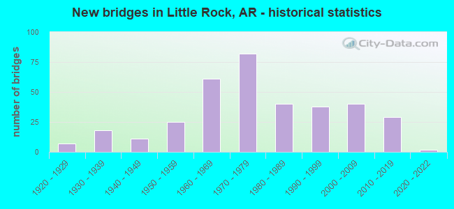
- New bridges - historical statistics
- 71920-1929
- 181930-1939
- 111940-1949
- 251950-1959
- 611960-1969
- 821970-1979
- 401980-1989
- 381990-1999
- 402000-2009
- 292010-2019
- 22020-2022

- Reconstructed bridges - Historical Statistics
- 11950-1959
- 21960-1969
- 201970-1979
- 131980-1989
- 51990-1999
- 22000-2009
- 42010-2019


- Bridge Condition - Deck
- 3.1%Excellent
- 13.0%Very good
- 41.4%Good
- 32.6%Satisfactory
- 9.6%Fair
- 0.4%Poor

- Bridge Condition - Superstructure
- 3.4%Excellent
- 18.8%Very good
- 31.0%Good
- 29.9%Satisfactory
- 14.6%Fair
- 2.3%Poor

- Bridge Condition - Substructure
- 2.3%Excellent
- 16.1%Very good
- 34.9%Good
- 33.3%Satisfactory
- 13.0%Fair
- 0.4%Poor

- Bridge Condition - Channel
- 21.8%Excellent
- 41.1%Very good
- 27.0%Good
- 9.3%Satisfactory
- 0.8%Fair
- 0.4%Poor

- Bridge Condition - Culverts
- 5.4%Excellent
- 20.7%Very good
- 51.1%Good
- 21.7%Satisfactory
- 1.1%Fair
Find on map >> Show street view
Structure Number: B57, Location: SO TERM INT-WE RP(I-8) (Lat: 34.708089, Lng: -92.275450), Route carried "under" structure: City street 21070, Structure Length: 0. m, Average Daily Traffic: 2,592 (year 1983), Truck Traffic: 1%, Features Intersected: Frazier Pike, Facility Carried by Structure: I-440 EB MAIN LANE
Minimum Vertical Clearance: 8.22m (26.97ft), Kilometerpoint: 0.000, Length of Maximum Span: 0.0m
Find on map >> Show street view
Structure Number: B57, Location: SO TERM INT-WE RP(I-8) (Lat: 34.708089, Lng: -92.275450), Route carried "under" structure: Interstate 530, Structure Length: 0. m, Average Daily Traffic: 22,000 (year 2013), Truck Traffic: 1%, Features Intersected: 530, Facility Carried by Structure: I-440 EB MAIN LANE
Minimum Vertical Clearance: 5.02m (16.47ft), Kilometerpoint: 0.679, Length of Maximum Span: 0.0m
Find on map >> Show street view
Structure Number: B57, Location: SO TERM INT-WE RP(I-8) (Lat: 34.708089, Lng: -92.275450), Route carried "under" structure: Interstate 530, Structure Length: 0. m, Average Daily Traffic: 22,000 (year 2013), Truck Traffic: 1%, Features Intersected: 530 N Off Ramp, Facility Carried by Structure: I-440 EB MAIN LANE
Minimum Vertical Clearance: 10.78m (35.37ft), Kilometerpoint: 0.689, Length of Maximum Span: 0.0m
Find on map >> Show street view
Structure Number: B57, Location: SO TERM INT-WE RP(I-8) (Lat: 34.708089, Lng: -92.275450), Route carried "under" structure: Interstate 530, Structure Length: 0. m, Average Daily Traffic: 22,000 (year 2013), Truck Traffic: 1%, Features Intersected: 530, Facility Carried by Structure: I-440 EB MAIN LANE
Minimum Vertical Clearance: 6.21m (20.37ft), Kilometerpoint: 0.689, Length of Maximum Span: 0.0m
Find on map >> Show street view
Structure Number: B57, Location: SO TERM INT-WE RP(I-8) (Lat: 34.708089, Lng: -92.275450), Route carried "under" structure: Interstate 530, Structure Length: 0. m, Average Daily Traffic: 91,000 (year 2014), Truck Traffic: 1%, Features Intersected: 530 S On Ramp, Facility Carried by Structure: I-440 EB MAIN LANE
Minimum Vertical Clearance: 6.85m (22.47ft), Kilometerpoint: 0.679, Length of Maximum Span: 0.0m
Find on map >> Show street view
Structure Number: B5703, Location: 3.7MI E OF US 65 (Lat: 34.716781, Lng: -92.213139), Route carried "under" structure: City street 33560, Structure Length: 0. m, Average Daily Traffic: 1,909 (year 1983), Truck Traffic: 1%, Features Intersected: LINDSEY ROAD, Facility Carried by Structure: I-440 EB Log 3.80
Minimum Vertical Clearance: 4.95m (16.24ft), Kilometerpoint: 0.531, Length of Maximum Span: 0.0m
Find on map >> Show street view
Structure Number: B5704, Location: .2MI N OF LINDSEY RD (Lat: 34.715969, Lng: -92.189861), Route carried "under" structure: City street 447, Structure Length: 0. m, Average Daily Traffic: 1,605 (year 1983), Truck Traffic: 1%, Features Intersected: FOURCHE DAM PIKE, Facility Carried by Structure: I-440 Log 5.16 EB
Minimum Vertical Clearance: 5.08m (16.67ft), Kilometerpoint: 1.802, Length of Maximum Span: 0.0m
Find on map >> Show street view
Structure Number: B6919, Location: I-30, Sec. 23, Log 130.62 (Lat: 34.670125, Lng: -92.380458), Route carried "under" structure: State highway 338, Structure Length: 0. m, Average Daily Traffic: 11,000 (year 2014), Truck Traffic: 1%, Features Intersected: SH 338/Baseline Rd., Facility Carried by Structure: I-30 EB Log 130.62
Minimum Vertical Clearance: 5.48m (17.98ft), Kilometerpoint: 3.396, Length of Maximum Span: 0.0m
Find on map >> Show street view
Structure Number: B692, Location: 2 MI NE JCT SH 338 (Lat: 34.679300, Lng: -92.354469), Route carried "under" structure: US 70, Structure Length: 0. m, Average Daily Traffic: 10,000 (year 2014), Truck Traffic: 1%, Features Intersected: US 70, U.P.R.R., Frnt Rd, Facility Carried by Structure: I-30 WB Log 132.18
Minimum Vertical Clearance: 6.22m (20.41ft), Kilometerpoint: 0.290, Length of Maximum Span: 0.0m
Find on map >> Show street view
Structure Number: B692, Location: 2 MI NE JCT SH 338 (Lat: 34.679300, Lng: -92.354469), Route carried "under" structure: ServiceInterstate 30, Structure Length: 0. m, Average Daily Traffic: 83,000 (year 2014), Truck Traffic: 1%, Features Intersected: US 70, U.P.R.R., Frnt Rd
Minimum Vertical Clearance: 7.66m (25.13ft), Kilometerpoint: 212.723, Length of Maximum Span: 0.0m
Find on map >> Show street view
Structure Number: B692, Location: 2 MI NE JCT SH 338 (Lat: 34.679300, Lng: -92.354469), Route carried "under" structure: US 70, Structure Length: 0. m, Average Daily Traffic: 10,000 (year 2014), Truck Traffic: 1%, Features Intersected: US 70, U.P.R.R., Frnt Rd, Facility Carried by Structure: I-30 WB Log 132.18
Minimum Vertical Clearance: 6.22m (20.41ft), Kilometerpoint: 0.290, Length of Maximum Span: 0.0m
Find on map >> Show street view
Structure Number: B7141, Location: .1 MI S Markham St. (Lat: 34.747911, Lng: -92.391539), Route carried "under" structure: Interstate 630, Structure Length: 0. m, Average Daily Traffic: 43,000 (year 2014), Truck Traffic: 15%, Features Intersected: I-630 Log 7.40 W.B. M.L., Facility Carried by Structure: I-430 SB Log 6.27
Minimum Vertical Clearance: 5.33m (17.49ft), Kilometerpoint: 11.909, Length of Maximum Span: 0.0m
Find on map >> Show street view
Structure Number: B7141, Location: .1 MI S Markham St. (Lat: 34.747911, Lng: -92.391539), Route carried "under" structure: Interstate 630, Structure Length: 0. m, Average Daily Traffic: 43,000 (year 2014), Truck Traffic: 15%, Features Intersected: I-630 Log 7.40 E.B. M.L., Facility Carried by Structure: I-430 SB Log 6.27
Minimum Vertical Clearance: 5.63m (18.47ft), Kilometerpoint: 11.909, Length of Maximum Span: 0.0m
Find on map >> Show street view
Structure Number: B7141, Location: .1 MI S Markham St. (Lat: 34.747911, Lng: -92.391539), Route carried "under" structure: Ramp Interstate 630, Structure Length: 0. m, Average Daily Traffic: 43,000 (year 2014), Truck Traffic: 15%, Features Intersected: I-630 Log 7.40 E.B. M.L., Facility Carried by Structure: I-430 SB Log 6.27
Minimum Vertical Clearance: 5.33m (17.49ft), Kilometerpoint: 11.909, Length of Maximum Span: 0.0m
Find on map >> Show street view
Structure Number: B7141, Location: .1 MI S Markham St. (Lat: 34.747911, Lng: -92.391539), Route carried "under" structure: Ramp Interstate 630, Structure Length: 0. m, Average Daily Traffic: 43,000 (year 2014), Truck Traffic: 15%, Features Intersected: I-630 Log 7.40 E.B. M.L., Facility Carried by Structure: I-430 SB Log 6.27
Minimum Vertical Clearance: 6.24m (20.47ft), Kilometerpoint: 11.909, Length of Maximum Span: 0.0m
Find on map >> Show street view
Structure Number: C3397, Location: 5.2 N OF SH 338 (Lat: 34.731331, Lng: -92.263381), Route carried "under" structure: City street 64690, Structure Length: 0. m, Average Daily Traffic: 5,181 (year 1983), Truck Traffic: 1%, Features Intersected: E 17TH STREET, Facility Carried by Structure: I 30-SEC 23 RAMP B
Minimum Vertical Clearance: 4.64m (15.22ft), Kilometerpoint: 0.998, Length of Maximum Span: 0.0m
Find on map >> Show street view
Structure Number: C57, Location: SO TERM NE RP (Lat: 34.709889, Lng: -92.270700), Route carried "under" structure: Interstate 530, Structure Length: 0. m, Average Daily Traffic: 22,000 (year 2013), Truck Traffic: 1%, Features Intersected: I440 OVER,I530,FOURCHE, Facility Carried by Structure: I 440 NE RAMP
Minimum Vertical Clearance: 6.85m (22.47ft), Kilometerpoint: 0.531, Length of Maximum Span: 0.0m
Find on map >> Show street view
Structure Number: C57, Location: SO TERM NE RP (Lat: 34.709889, Lng: -92.270700), Route carried "under" structure: Interstate 530, Structure Length: 0. m, Average Daily Traffic: 22,000 (year 2013), Truck Traffic: 1%, Features Intersected: I440 OVER,I530,FOURCHE, Facility Carried by Structure: I 440 NE RAMP
Minimum Vertical Clearance: 5.27m (17.29ft), Kilometerpoint: 0.531, Length of Maximum Span: 0.0m
Find on map >> Show street view
Structure Number: C692, Location: I-30 log 132.19 (Lat: 34.679600, Lng: -92.354300), Route carried "under" structure: ServiceInterstate 30, Structure Length: 0. m, Average Daily Traffic: 83,000 (year 2014), Truck Traffic: 1%, Features Intersected: U.S. 70, U.P.R.R.,Frt.Rd
Minimum Vertical Clearance: 7.89m (25.89ft), Kilometerpoint: 212.707, Length of Maximum Span: 0.0m
Find on map >> Show street view
Structure Number: C692, Location: I-30 log 132.19 (Lat: 34.679600, Lng: -92.354300), Route carried "under" structure: US 70, Structure Length: 0. m, Average Daily Traffic: 10,000 (year 2014), Truck Traffic: 1%, Features Intersected: U.S. 70, U.P.R.R.,Frt.Rd, Facility Carried by Structure: I-30 Ramp
Minimum Vertical Clearance: 6.07m (19.91ft), Kilometerpoint: 0.322, Length of Maximum Span: 0.0m
Find on map >> Show street view
Structure Number: C692, Location: I-30 log 132.19 (Lat: 34.679600, Lng: -92.354300), Route carried "under" structure: US 70, Structure Length: 0. m, Average Daily Traffic: 10,000 (year 2014), Truck Traffic: 1%, Features Intersected: U.S. 70, U.P.R.R.,Frt.Rd, Facility Carried by Structure: I-30 Ramp
Minimum Vertical Clearance: 6.22m (20.41ft), Kilometerpoint: 0.322, Length of Maximum Span: 0.0m
Find on map >> Show street view
Structure Number: C7141, Location: .1 MI SO Markham St (Lat: 34.747900, Lng: -92.391100), Route carried "under" structure: Interstate 630, Structure Length: 0. m, Average Daily Traffic: 43,000 (year 2014), Truck Traffic: 15%, Features Intersected: I-630 Log 7.40 W.B. M.L., Facility Carried by Structure: I-430 NB Ramp
Minimum Vertical Clearance: 5.02m (16.47ft), Kilometerpoint: 11.909, Length of Maximum Span: 0.0m
Find on map >> Show street view
Structure Number: C7141, Location: .1 MI SO Markham St (Lat: 34.747900, Lng: -92.391100), Route carried "under" structure: Ramp Interstate 630, Structure Length: 0. m, Average Daily Traffic: 43,000 (year 2014), Truck Traffic: 15%, Features Intersected: I-630 Log 7.40, Facility Carried by Structure: I-430 NB Ramp
Minimum Vertical Clearance: 4.93m (16.17ft), Kilometerpoint: 11.909, Length of Maximum Span: 0.0m
Find on map >> Show street view
Structure Number: C7141, Location: .1 MI SO Markham St (Lat: 34.747900, Lng: -92.391100), Route carried "under" structure: Interstate 630, Structure Length: 0. m, Average Daily Traffic: 43,000 (year 2014), Truck Traffic: 15%, Features Intersected: I-630 Log 7.40, Facility Carried by Structure: I-430 NB Ramp
Minimum Vertical Clearance: 5.35m (17.55ft), Kilometerpoint: 11.909, Length of Maximum Span: 0.0m
Find on map >> Show street view
Structure Number: C7141, Location: .1 MI SO Markham St (Lat: 34.747900, Lng: -92.391100), Route carried "under" structure: Ramp Interstate 630, Structure Length: 0. m, Average Daily Traffic: 43,000 (year 2014), Truck Traffic: 15%, Features Intersected: I-630 Log 7.40, Facility Carried by Structure: I-430 NB Ramp
Minimum Vertical Clearance: 5.91m (19.39ft), Kilometerpoint: 11.909, Length of Maximum Span: 0.0m
Find on map >> Show street view
Structure Number: D7141, Location: .1 MI S Markham St. (Lat: 34.747911, Lng: -92.391719), Route carried "under" structure: Ramp Interstate 630, Structure Length: 0. m, Average Daily Traffic: 43,000 (year 2014), Truck Traffic: 15%, Features Intersected: I-630 Log 7.40, Facility Carried by Structure: I-430 SB Ramp
Minimum Vertical Clearance: 5.41m (17.75ft), Kilometerpoint: 11.909, Length of Maximum Span: 0.0m
Find on map >> Show street view
Structure Number: D7141, Location: .1 MI S Markham St. (Lat: 34.747911, Lng: -92.391719), Route carried "under" structure: Interstate 630, Structure Length: 0. m, Average Daily Traffic: 43,000 (year 2014), Truck Traffic: 1%, Features Intersected: I-630 Log 7.40, Facility Carried by Structure: I-430 SB Ramp
Minimum Vertical Clearance: 5.66m (18.57ft), Kilometerpoint: 11.909, Length of Maximum Span: 0.0m
Find on map >> Show street view
Structure Number: D7141, Location: .1 MI S Markham St. (Lat: 34.747911, Lng: -92.391719), Route carried "under" structure: Ramp Interstate 630, Structure Length: 0. m, Average Daily Traffic: 43,000 (year 2014), Truck Traffic: 15%, Features Intersected: I-630 Log 7.40, Facility Carried by Structure: I-430 SB Ramp
Minimum Vertical Clearance: 6.27m (20.57ft), Kilometerpoint: 11.909, Length of Maximum Span: 0.0m
Find on map >> Show street view
Structure Number: D7141, Location: .1 MI S Markham St. (Lat: 34.747911, Lng: -92.391719), Route carried "under" structure: Interstate 630, Structure Length: 0. m, Average Daily Traffic: 43,000 (year 2014), Truck Traffic: 15%, Features Intersected: I-630 Log 7.40, Facility Carried by Structure: I-430 SB Ramp
Minimum Vertical Clearance: 5.33m (17.49ft), Kilometerpoint: 11.909, Length of Maximum Span: 0.0m
Find on map >> Show street view
Structure Number: F57, Location: SO TERM E S Ramp (Lat: 34.710261, Lng: -92.271161), Route carried "under" structure: Interstate 30, Structure Length: 0. m, Average Daily Traffic: 45,500 (year 2014), Truck Traffic: 1%, Features Intersected: I 30-SEC 23 ML, Facility Carried by Structure: I-440 ES RAMP
Minimum Vertical Clearance: 4.93m (16.17ft), Kilometerpoint: 222.428, Length of Maximum Span: 0.0m
Find on map >> Show street view
Structure Number: F57, Location: SO TERM E S Ramp (Lat: 34.710261, Lng: -92.271161), Route carried "under" structure: Interstate 30, Structure Length: 0. m, Average Daily Traffic: 45,500 (year 2014), Truck Traffic: 1%, Features Intersected: I 30-SEC 23 ML, Facility Carried by Structure: I-440 ES RAMP
Minimum Vertical Clearance: 6.88m (22.57ft), Kilometerpoint: 221.929, Length of Maximum Span: 0.0m
Find on map >> Show street view
Structure Number: F57, Location: SO TERM E S Ramp (Lat: 34.710261, Lng: -92.271161), Route carried "under" structure: Interstate 30, Structure Length: 0. m, Average Daily Traffic: 45,500 (year 2014), Truck Traffic: 1%, Features Intersected: I 30-SEC 23 ML, Facility Carried by Structure: I-440 ES RAMP
Minimum Vertical Clearance: 5.21m (17.09ft), Kilometerpoint: 222.428, Length of Maximum Span: 0.0m
Find on map >> Show street view
Structure Number: F57, Location: SO TERM E S Ramp (Lat: 34.710261, Lng: -92.271161), Route carried "under" structure: Interstate 30, Structure Length: 0. m, Average Daily Traffic: 45,500 (year 2014), Truck Traffic: 1%, Features Intersected: I 30-SEC 23 ML, Facility Carried by Structure: I-440 ES RAMP
Minimum Vertical Clearance: 5.33m (17.49ft), Kilometerpoint: 221.945, Length of Maximum Span: 0.0m
Find on map >> Show street view
Structure Number: J2768, Location: 2.5 MI SO OF I - 40 (Lat: 34.743961, Lng: -92.262950), Route carried "under" structure: City street 64490, Structure Length: 0. m, Average Daily Traffic: 2,509 (year 1983), Truck Traffic: 1%, Features Intersected: 4th Street, Facility Carried by Structure: I-30 Log 140.35
Minimum Vertical Clearance: 4.41m (14.47ft), Kilometerpoint: 0.756, Length of Maximum Span: 0.0m