Bridge Statistics for Little Rock, Arkansas (AR)
Condition, Traffic, Stress, Structural Evaluation, Project Costs
- National Bridge Inventory (NBI) Statistics
- 640Number of bridges
- 11,677ft / 3,559mTotal length
- $76,837,000Total costs
- 14,587,333Total average daily traffic
- 541,775Total average daily truck traffic
- National Bridge Inventory (NBI) Registered Bridges for Little Rock
- No street view available for this location
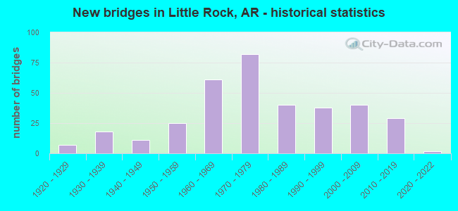
- New bridges - historical statistics
- 71920-1929
- 181930-1939
- 111940-1949
- 251950-1959
- 611960-1969
- 821970-1979
- 401980-1989
- 381990-1999
- 402000-2009
- 292010-2019
- 22020-2022

- Reconstructed bridges - Historical Statistics
- 11950-1959
- 21960-1969
- 201970-1979
- 131980-1989
- 51990-1999
- 22000-2009
- 42010-2019


- Bridge Condition - Deck
- 3.1%Excellent
- 13.0%Very good
- 41.4%Good
- 32.6%Satisfactory
- 9.6%Fair
- 0.4%Poor

- Bridge Condition - Superstructure
- 3.4%Excellent
- 18.8%Very good
- 31.0%Good
- 29.9%Satisfactory
- 14.6%Fair
- 2.3%Poor

- Bridge Condition - Substructure
- 2.3%Excellent
- 16.1%Very good
- 34.9%Good
- 33.3%Satisfactory
- 13.0%Fair
- 0.4%Poor

- Bridge Condition - Channel
- 21.8%Excellent
- 41.1%Very good
- 27.0%Good
- 9.3%Satisfactory
- 0.8%Fair
- 0.4%Poor

- Bridge Condition - Culverts
- 5.4%Excellent
- 20.7%Very good
- 51.1%Good
- 21.7%Satisfactory
- 1.1%Fair
Find on map >> Show street view
Structure Number: J2768, Location: 2.5 MI SO OF I - 40 (Lat: 34.743961, Lng: -92.262950), Route carried "on" structure: Interstate 30, Year Built: 1961, Status: Open, Structure Length: 2.71m (8.89ft), Average Daily Traffic: 119,000 (year 2018), Truck Traffic: 1%, Average Future Daily Traffic: 150,355 (year 2028), Design Load: HS 20+Mod, Features Intersected: 4th Street
Minimum Vertical Clearance: 30+ m (98+ ft), Kilometerpoint: 225.872, Lanes on structure: 8, Lanes under structure: 2, Base Highway Network: Yes, Owner: State Highway Agency, Approaching Roadway Width: 30.2m (99.1ft), Skew: 30 degrees, Material/Design: Steel, Design/Construction: Stringer/Multi-beam, Number Of Spans In Main Unit: 1, Length of Maximum Span: 27.1m (88.9ft), Curb-To-Curb Width: 32.6m (107.0ft), Out-to-Out Width: 34.1m (111.9ft)
Condition: Deck: Good, Superstructure: Good, Substructure: Satisfactory, Operating Rating: 54.4 metric tons, Method Used To Determine Operating Rating: Load Factor (LF), Inventory Rating: 32.7 metric tons, Method Used To Determine Inventory Rating: Load Factor (LF), Structural Evaluation: Equal to present minimum criteria, Deck Geometry: Meets minimum limits, Underclear: Equal to present minimum criteria, Approach Roadway Alignment: Equal to present desirable criteria, Length Of Structure Improvement: 3.51m (11.52ft), Designated Inspection Frequency: Every 24 months, Critical Feature Inspection Frequency: Every 24 months, Inspection Date: September 2020, Deck Structure Type: Concrete Cast-file-Place
Find on map >> Show street view
Structure Number: J57, Location: HWY 365 W B ON RAMP (Lat: 34.715639, Lng: -92.255547), Route carried "on" structure: Ramp Interstate 440, Year Built: 1980, Status: Open, Structure Length: 43.19m (141.70ft), Average Daily Traffic: 1,499 (year 2018), Truck Traffic: 1%, Average Future Daily Traffic: 1,200 (year 2028), Design Load: HS 20, Features Intersected: FOURCHE CREEK
Minimum Vertical Clearance: 30+ m (98+ ft), Kilometerpoint: 2.301, Lanes on structure: 1, Owner: State Highway Agency, Approaching Roadway Width: 7.6m (24.9ft), Material/Design: Steel, Design/Construction: Stringer/Multi-beam, Number Of Spans In Main Unit: 27, Length of Maximum Span: 22.9m (75.1ft), Curb-To-Curb Width: 7.6m (24.9ft), Out-to-Out Width: 8.5m (27.9ft)
Condition: Deck: Good, Superstructure: Satisfactory, Substructure: Fair, Channel: Fair, Operating Rating: 54.4 metric tons, Method Used To Determine Operating Rating: Load Factor (LF), Inventory Rating: 32.7 metric tons, Method Used To Determine Inventory Rating: Load Factor (LF), Structural Evaluation: Somewhat better than minimum adequacy, Deck Geometry: Better than present minimum criteria, Waterway Adequacy: Equal to present desirable criteria, Approach Roadway Alignment: Equal to present desirable criteria, Designated Inspection Frequency: Every 24 months, Critical Feature Inspection Frequency: Every 24 months, Inspection Date: April 2021, Deck Structure Type: Concrete Cast-file-Place, Wearing Surface/Protective System: Wearing Surface: Monolithic Concrete
Find on map >> Show street view
Structure Number: M0129, Location: 1.0 MI E I-430 (Lat: 34.691161, Lng: -92.392731), Route carried "on" structure: State highway 70, Year Built: 1920, Status: Posted for load, Structure Length: 0.68m (2.23ft), Average Daily Traffic: 10,572 (year 2018), Truck Traffic: 1%, Average Future Daily Traffic: 11,277 (year 2028), Features Intersected: BRANCH, Facility Carried by Structure: SH 5 Log 4.51
Minimum Vertical Clearance: 30+ m (98+ ft), Kilometerpoint: 1.635, Lanes on structure: 2, Base Highway Network: Yes, Owner: State Highway Agency, Approaching Roadway Width: 9.1m (29.9ft), Material/Design: Concrete, Design/Construction: Slab, Number Of Spans In Main Unit: 1, Length of Maximum Span: 6.1m (20.0ft), Curb or Sidewalk Widths: Left: 0.4m (1.3ft), Right: 0.4m (1.3ft), Curb-To-Curb Width: 9.1m (29.9ft), Out-to-Out Width: 9.8m (32.2ft)
Condition: Deck: Fair, Superstructure: Fair, Substructure: Good, Channel: Satisfactory, Operating Rating: 29.9 metric tons, Method Used To Determine Operating Rating: Load Factor (LF), Inventory Rating: 18.1 metric tons, Method Used To Determine Inventory Rating: Load Factor (LF), Structural Evaluation: Meets minimum limits, Deck Geometry: High priority of corrective action, Waterway Adequacy: Equal to present minimum criteria, Approach Roadway Alignment: Better than present minimum criteria, Bridge Posting: Required (Relationship of Operating Rating to Maximum Legal Load: 10.0 - 19.9% below), Length Of Structure Improvement: 1.37m (4.49ft), Designated Inspection Frequency: Every 24 months, Critical Feature Inspection Frequency: Every 24 months, Inspection Date: October 2021, Roadway Improvement Cost: $306,000, Total Project Cost: $512,000, Deck Structure Type: Concrete Cast-file-Place, Wearing Surface/Protective System: Wearing Surface: Bituminous
Find on map >> Show street view
Structure Number: M0328, Location: 1 MI EAST OF SH 300 (Lat: 34.810497, Lng: -92.479919), Route carried "on" structure: State highway 10, Year Built: 1942, Year Reconstructed: 1992, Status: Open, Structure Length: 0.67m (2.20ft), Average Daily Traffic: 19,000 (year 2018), Truck Traffic: 1%, Average Future Daily Traffic: 22,035 (year 2028), Design Load: H 15, Features Intersected: DITCH
Minimum Vertical Clearance: 30+ m (98+ ft), Kilometerpoint: 3.990, Lanes on structure: 5, Base Highway Network: Yes, Owner: State Highway Agency, Approaching Roadway Width: 21.9m (71.9ft), Material/Design: Concrete, Design/Construction: Culvert, Number Of Spans In Main Unit: 2, Length of Maximum Span: 3.4m (11.2ft)
Condition: Channel: Good, Culverts: Very good, Operating Rating: 39.9 metric tons, Method Used To Determine Operating Rating: Load Factor (LF), Inventory Rating: 23.6 metric tons, Method Used To Determine Inventory Rating: Load Factor (LF), Structural Evaluation: Somewhat better than minimum adequacy, Waterway Adequacy: Equal to present desirable criteria, Approach Roadway Alignment: Equal to present desirable criteria, Designated Inspection Frequency: Every 24 months, Critical Feature Inspection Frequency: Every 24 months, Inspection Date: April 2020
Find on map >> Show street view
Structure Number: M0329, Location: 2.35 E SH 300 (Lat: 34.803789, Lng: -92.459769), Route carried "on" structure: State highway 10, Year Built: 1924, Year Reconstructed: 1992, Status: Open, Structure Length: 0.64m (2.10ft), Average Daily Traffic: 19,000 (year 2018), Truck Traffic: 1%, Average Future Daily Traffic: 22,035 (year 2028), Design Load: H 15, Features Intersected: DITCH
Minimum Vertical Clearance: 30+ m (98+ ft), Kilometerpoint: 6.017, Lanes on structure: 6, Base Highway Network: Yes, Owner: State Highway Agency, Approaching Roadway Width: 17.7m (58.1ft), Material/Design: Concrete, Design/Construction: Culvert, Number Of Spans In Main Unit: 2, Length of Maximum Span: 3.0m (9.8ft), Curb-To-Curb Width: 21.9m (71.9ft), Out-to-Out Width: 29.6m (97.1ft)
Condition: Channel: Good, Culverts: Very good, Operating Rating: 41.7 metric tons, Method Used To Determine Operating Rating: Load Factor (LF), Inventory Rating: 25.4 metric tons, Method Used To Determine Inventory Rating: Load Factor (LF), Structural Evaluation: Equal to present minimum criteria, Deck Geometry: High priority of corrective action, Waterway Adequacy: Equal to present desirable criteria, Approach Roadway Alignment: Equal to present desirable criteria, Designated Inspection Frequency: Every 24 months, Critical Feature Inspection Frequency: Every 24 months, Inspection Date: April 2020
Find on map >> Show street view
Structure Number: M033, Location: 2.39 E OF SH 300 (Lat: 34.803439, Lng: -92.458969), Route carried "on" structure: State highway 10, Year Built: 1924, Year Reconstructed: 1992, Status: Open, Structure Length: 0.64m (2.10ft), Average Daily Traffic: 19,000 (year 2018), Truck Traffic: 1%, Average Future Daily Traffic: 22,035 (year 2028), Design Load: H 15, Features Intersected: BRANCH
Minimum Vertical Clearance: 30+ m (98+ ft), Kilometerpoint: 6.098, Lanes on structure: 5, Base Highway Network: Yes, Owner: State Highway Agency, Approaching Roadway Width: 17.7m (58.1ft), Material/Design: Concrete, Design/Construction: Culvert, Number Of Spans In Main Unit: 2, Length of Maximum Span: 3.0m (9.8ft), Curb-To-Curb Width: 29.6m (97.1ft), Out-to-Out Width: 30.2m (99.1ft)
Condition: Channel: Good, Culverts: Good, Operating Rating: 41.7 metric tons, Method Used To Determine Operating Rating: Load Factor (LF), Inventory Rating: 25.4 metric tons, Method Used To Determine Inventory Rating: Load Factor (LF), Structural Evaluation: Equal to present minimum criteria, Deck Geometry: Superior to present desirable criteria, Waterway Adequacy: Equal to present desirable criteria, Approach Roadway Alignment: Equal to present desirable criteria, Designated Inspection Frequency: Every 24 months, Critical Feature Inspection Frequency: Every 24 months, Inspection Date: April 2020
Find on map >> Show street view
Structure Number: M0331, Location: 3.0 MI E SH 300 (Lat: 34.802439, Lng: -92.445850), Route carried "on" structure: State highway 10, Year Built: 1924, Year Reconstructed: 1984, Status: Open, Structure Length: 1.16m (3.81ft), Average Daily Traffic: 25,387 (year 2018), Truck Traffic: 1%, Average Future Daily Traffic: 33,700 (year 2028), Design Load: H 20, Features Intersected: DITCH
Minimum Vertical Clearance: 30+ m (98+ ft), Kilometerpoint: 7.306, Lanes on structure: 5, Base Highway Network: Yes (Inventory Route: 100, Subroute: 10), Owner: State Highway Agency, Approaching Roadway Width: 16.5m (54.1ft), Material/Design: Concrete, Design/Construction: Culvert, Number Of Spans In Main Unit: 4, Length of Maximum Span: 3.0m (9.8ft), Curb-To-Curb Width: 16.5m (54.1ft), Out-to-Out Width: 23.1m (75.8ft)
Condition: Channel: Satisfactory, Culverts: Very good, Operating Rating: 41.7 metric tons, Method Used To Determine Operating Rating: Load Factor (LF), Inventory Rating: 25.4 metric tons, Method Used To Determine Inventory Rating: Load Factor (LF), Structural Evaluation: Equal to present minimum criteria, Deck Geometry: High priority of replacement, Waterway Adequacy: Equal to present desirable criteria, Approach Roadway Alignment: Equal to present desirable criteria, Designated Inspection Frequency: Every 24 months, Critical Feature Inspection Frequency: Every 24 months, Inspection Date: January 2022
Find on map >> Show street view
Structure Number: M0336, Location: SH 10 @ U.P.R.R. (Lat: 34.752600, Lng: -92.283339), Route carried "on" structure: State highway 10, Year Built: 1927, Status: Open, Structure Length: 4.12m (13.52ft), Average Daily Traffic: 27,000 (year 2018), Truck Traffic: 1%, Average Future Daily Traffic: 20,091 (year 2028), Design Load: H 15, Features Intersected: UNION PACIFIC RR
Minimum Vertical Clearance: 5.39m (17.68ft), Kilometerpoint: 24.296, Lanes on structure: 2, Base Highway Network: Yes, Owner: State Highway Agency, Approaching Roadway Width: 9.1m (29.9ft), Material/Design: Concrete, Design/Construction: Arch - Thru, Number Of Spans In Main Unit: 1, Number Of Approach Spans: 2, Length of Maximum Span: 27.4m (89.9ft), Curb or Sidewalk Widths: Left: 1.7m (5.6ft), Right: 2.4m (7.9ft), Curb-To-Curb Width: 9.2m (30.2ft), Out-to-Out Width: 11.0m (36.1ft)
Condition: Deck: Satisfactory, Superstructure: Fair, Substructure: Satisfactory, Operating Rating: 28.1 metric tons, Method Used To Determine Operating Rating: Field evaluation and documented engineering judgment, Inventory Rating: 17.2 metric tons, Method Used To Determine Inventory Rating: Field evaluation and documented engineering judgment, Structural Evaluation: Meets minimum limits, Deck Geometry: Meets minimum limits, Underclear: Superior to present desirable criteria, Approach Roadway Alignment: Equal to present minimum criteria, Length Of Structure Improvement: 4.39m (14.40ft), Designated Inspection Frequency: Every 24 months, Inspection Date: Febuary 2022, Total Project Cost: $322,000, Deck Structure Type: Concrete Cast-file-Place, Wearing Surface/Protective System: Wearing Surface: Bituminous
Find on map >> Show street view
Structure Number: M1194, Location: 1.0 MI S I 30 (Lat: 34.696169, Lng: -92.270119), Route carried "on" structure: Interstate 530, Year Built: 1961, Status: Open, Structure Length: 1.04m (3.41ft), Average Daily Traffic: 45,000 (year 2018), Truck Traffic: 12%, Average Future Daily Traffic: 54,439 (year 2028), Features Intersected: CREEK
Minimum Vertical Clearance: 30+ m (98+ ft), Kilometerpoint: 1.915, Lanes on structure: 4, Base Highway Network: Yes, Owner: State Highway Agency, Approaching Roadway Width: 22.6m (74.1ft), Skew: 3 degrees, Material/Design: Concrete, Design/Construction: Culvert, Number Of Spans In Main Unit: 2, Length of Maximum Span: 5.2m (17.1ft)
Condition: Channel: Good, Culverts: Satisfactory, Operating Rating: 41.7 metric tons, Method Used To Determine Operating Rating: Load Factor (LF), Inventory Rating: 25.4 metric tons, Method Used To Determine Inventory Rating: Load Factor (LF), Structural Evaluation: Equal to present minimum criteria, Waterway Adequacy: Equal to present desirable criteria, Approach Roadway Alignment: Equal to present desirable criteria, Designated Inspection Frequency: Every 24 months, Critical Feature Inspection Frequency: Every 24 months, Inspection Date: July 2020
Find on map >> Show street view
Structure Number: M1195, Location: 0.8 MI S SH 338 (Lat: 34.659589, Lng: -92.262219), Route carried "on" structure: Interstate 530, Year Built: 1961, Status: Open, Structure Length: 0.67m (2.20ft), Average Daily Traffic: 39,000 (year 2018), Truck Traffic: 10%, Average Future Daily Traffic: 47,958 (year 2028), Features Intersected: FISH CREEK
Minimum Vertical Clearance: 30+ m (98+ ft), Kilometerpoint: 6.083, Lanes on structure: 4, Base Highway Network: Yes, Owner: State Highway Agency, Approaching Roadway Width: 23.2m (76.1ft), Skew: 10 degrees, Material/Design: Concrete, Design/Construction: Culvert, Number Of Spans In Main Unit: 2, Length of Maximum Span: 3.4m (11.2ft)
Condition: Channel: Satisfactory, Culverts: Good, Operating Rating: 39.9 metric tons, Method Used To Determine Operating Rating: Load Factor (LF), Inventory Rating: 23.6 metric tons, Method Used To Determine Inventory Rating: Load Factor (LF), Structural Evaluation: Somewhat better than minimum adequacy, Waterway Adequacy: Equal to present minimum criteria, Approach Roadway Alignment: Equal to present desirable criteria, Designated Inspection Frequency: Every 24 months, Critical Feature Inspection Frequency: Every 24 months, Inspection Date: July 2020
Find on map >> Show street view
Structure Number: M1324, Location: .3 MI E OF SH 5 (Lat: 34.718550, Lng: -92.336489), Route carried "on" structure: US 70, Year Built: 1930, Year Reconstructed: 1979, Status: Open, Structure Length: 1.62m (5.31ft), Average Daily Traffic: 25,625 (year 2018), Truck Traffic: 1%, Average Future Daily Traffic: 34,997 (year 2028), Design Load: H 15, Features Intersected: COLEMAN CREEK
Minimum Vertical Clearance: 30+ m (98+ ft), Kilometerpoint: 8.211, Lanes on structure: 5, Base Highway Network: Yes, Owner: State Highway Agency, Approaching Roadway Width: 18.3m (60.0ft), Material/Design: Concrete, Design/Construction: Culvert, Number Of Spans In Main Unit: 4, Length of Maximum Span: 3.7m (12.1ft), Curb-To-Curb Width: 18.3m (60.0ft), Out-to-Out Width: 26.4m (86.6ft)
Condition: Channel: Good, Culverts: Satisfactory, Operating Rating: 31.8 metric tons, Method Used To Determine Operating Rating: Load Factor (LF), Inventory Rating: 19.1 metric tons, Method Used To Determine Inventory Rating: Load Factor (LF), Structural Evaluation: Meets minimum limits, Deck Geometry: High priority of replacement, Waterway Adequacy: Equal to present desirable criteria, Approach Roadway Alignment: Equal to present desirable criteria, Designated Inspection Frequency: Every 24 months, Critical Feature Inspection Frequency: Every 24 months, Inspection Date: April 2020
Find on map >> Show street view
Structure Number: M1325, Location: 1 MI E of Asher&Univ (Lat: 34.722669, Lng: -92.326186), Route carried "on" structure: US 70, Year Built: 1935, Status: Open, Structure Length: 1.04m (3.41ft), Average Daily Traffic: 25,144 (year 2018), Truck Traffic: 1%, Average Future Daily Traffic: 34,997 (year 2028), Design Load: H 15, Features Intersected: BLAKEMORE CREEK
Minimum Vertical Clearance: 30+ m (98+ ft), Kilometerpoint: 9.276, Lanes on structure: 4, Base Highway Network: Yes, Owner: State Highway Agency, Approaching Roadway Width: 13.7m (44.9ft), Material/Design: Concrete, Design/Construction: Culvert, Number Of Spans In Main Unit: 3, Length of Maximum Span: 3.0m (9.8ft), Curb-To-Curb Width: 13.7m (44.9ft), Out-to-Out Width: 21.3m (69.9ft)
Condition: Channel: Very good, Culverts: Satisfactory, Operating Rating: 35.4 metric tons, Method Used To Determine Operating Rating: Load Factor (LF), Inventory Rating: 21.8 metric tons, Method Used To Determine Inventory Rating: Load Factor (LF), Structural Evaluation: Somewhat better than minimum adequacy, Deck Geometry: High priority of replacement, Waterway Adequacy: Equal to present desirable criteria, Approach Roadway Alignment: Equal to present desirable criteria, Designated Inspection Frequency: Every 24 months, Critical Feature Inspection Frequency: Every 24 months, Inspection Date: April 2020
Find on map >> Show street view
Structure Number: M1326, Location: 1.3 MI E OF SH 5 (Lat: 34.724478, Lng: -92.321678), Route carried "on" structure: US 70, Year Built: 1935, Status: Open, Structure Length: 0.70m (2.30ft), Average Daily Traffic: 25,144 (year 2018), Truck Traffic: 1%, Average Future Daily Traffic: 34,997 (year 2028), Design Load: H 15, Features Intersected: CREEK
Minimum Vertical Clearance: 30+ m (98+ ft), Kilometerpoint: 9.725, Lanes on structure: 4, Base Highway Network: Yes, Owner: State Highway Agency, Approaching Roadway Width: 12.2m (40.0ft), Material/Design: Concrete, Design/Construction: Culvert, Number Of Spans In Main Unit: 2, Length of Maximum Span: 3.0m (9.8ft), Curb or Sidewalk Widths: Left: 1.8m (5.9ft), Right: 1.8m (5.9ft), Curb-To-Curb Width: 16.3m (53.5ft), Out-to-Out Width: 20.0m (65.6ft)
Condition: Channel: Very good, Culverts: Satisfactory, Operating Rating: 35.4 metric tons, Method Used To Determine Operating Rating: Load Factor (LF), Inventory Rating: 21.8 metric tons, Method Used To Determine Inventory Rating: Load Factor (LF), Structural Evaluation: Somewhat better than minimum adequacy, Deck Geometry: Meets minimum limits, Waterway Adequacy: Better than present minimum criteria, Approach Roadway Alignment: Equal to present desirable criteria, Length Of Structure Improvement: 1.40m (4.59ft), Designated Inspection Frequency: Every 24 months, Critical Feature Inspection Frequency: Every 24 months, Inspection Date: April 2020, Roadway Improvement Cost: $1,177,000, Total Project Cost: $2,215,000
Find on map >> Show street view
Structure Number: M1327, Location: ROOSEVELT @ Pulaski St. (Lat: 34.724800, Lng: -92.288589), Route carried "on" structure: US 70, Year Built: 1935, Status: Open, Structure Length: 1.04m (3.41ft), Average Daily Traffic: 12,410 (year 2018), Truck Traffic: 1%, Average Future Daily Traffic: 16,850 (year 2028), Design Load: H 20, Features Intersected: SWAGGERTY BRANCH
Minimum Vertical Clearance: 30+ m (98+ ft), Kilometerpoint: 12.788, Lanes on structure: 4, Base Highway Network: Yes, Owner: State Highway Agency, Approaching Roadway Width: 11.0m (36.1ft), Material/Design: Concrete, Design/Construction: Culvert, Number Of Spans In Main Unit: 3, Length of Maximum Span: 3.0m (9.8ft), Curb-To-Curb Width: 11.1m (36.4ft), Out-to-Out Width: 19.5m (64.0ft)
Condition: Channel: Very good, Culverts: Good, Operating Rating: 35.4 metric tons, Method Used To Determine Operating Rating: Load Factor (LF), Inventory Rating: 21.8 metric tons, Method Used To Determine Inventory Rating: Load Factor (LF), Structural Evaluation: Somewhat better than minimum adequacy, Deck Geometry: High priority of replacement, Waterway Adequacy: Equal to present desirable criteria, Approach Roadway Alignment: Equal to present desirable criteria, Length Of Structure Improvement: 1.04m (3.41ft), Designated Inspection Frequency: Every 24 months, Critical Feature Inspection Frequency: Every 24 months, Inspection Date: April 2020, Roadway Improvement Cost: $305,000, Total Project Cost: $471,000
Find on map >> Show street view
Structure Number: M2981, Location: 0.1 M S OF SH 338 (Lat: 34.653089, Lng: -92.306008), Route carried "on" structure: State highway 367, Year Built: 1943, Status: Open, Structure Length: 0.91m (2.99ft), Average Daily Traffic: 11,000 (year 2018), Truck Traffic: 1%, Average Future Daily Traffic: 12,962 (year 2028), Design Load: H 15, Features Intersected: DITCH
Minimum Vertical Clearance: 30+ m (98+ ft), Kilometerpoint: 8.319, Lanes on structure: 2, Base Highway Network: Yes, Owner: State Highway Agency, Approaching Roadway Width: 11.0m (36.1ft), Material/Design: Concrete, Design/Construction: Slab, Number Of Spans In Main Unit: 2, Length of Maximum Span: 4.6m (15.1ft), Curb-To-Curb Width: 13.0m (42.7ft), Out-to-Out Width: 13.4m (44.0ft)
Condition: Deck: Good, Superstructure: Good, Substructure: Fair, Channel: Fair, Operating Rating: 36.3 metric tons, Method Used To Determine Operating Rating: Load Factor (LF), Inventory Rating: 21.8 metric tons, Method Used To Determine Inventory Rating: Load Factor (LF), Structural Evaluation: Somewhat better than minimum adequacy, Deck Geometry: Somewhat better than minimum adequacy, Waterway Adequacy: Better than present minimum criteria, Approach Roadway Alignment: Equal to present desirable criteria, Designated Inspection Frequency: Every 24 months, Critical Feature Inspection Frequency: Every 24 months, Inspection Date: March 2020, Deck Structure Type: Concrete Cast-file-Place, Wearing Surface/Protective System: Wearing Surface: Bituminous
Find on map >> Show street view
Structure Number: M3033, Location: 1.2 MI NE SH 338(I10) (Lat: 34.676550, Lng: -92.363669), Route carried "on" structure: Interstate 30, Year Built: 1952, Year Reconstructed: 2003, Status: Open, Structure Length: 1.74m (5.71ft), Average Daily Traffic: 82,346 (year 2018), Truck Traffic: 26%, Average Future Daily Traffic: 106,286 (year 2028), Features Intersected: YOUNG CREEK
Minimum Vertical Clearance: 30+ m (98+ ft), Kilometerpoint: 211.935, Lanes on structure: 10, Base Highway Network: Yes, Owner: State Highway Agency, Approaching Roadway Width: 18.9m (62.0ft), Material/Design: Concrete, Design/Construction: Culvert, Number Of Spans In Main Unit: 5, Length of Maximum Span: 4.0m (13.1ft)
Condition: Channel: Fair, Culverts: Satisfactory, Operating Rating: 31.8 metric tons, Method Used To Determine Operating Rating: Load Factor (LF), Inventory Rating: 19.1 metric tons, Method Used To Determine Inventory Rating: Load Factor (LF), Structural Evaluation: Meets minimum limits, Waterway Adequacy: Equal to present desirable criteria, Approach Roadway Alignment: Equal to present desirable criteria, Designated Inspection Frequency: Every 24 months, Critical Feature Inspection Frequency: Every 24 months, Inspection Date: September 2021
Find on map >> Show street view
Structure Number: M3326, Location: W 32ND ST UALR (Lat: 34.722950, Lng: -92.337561), Route carried "on" structure: State highway 873, Year Built: 1970, Status: Posted for load, Structure Length: 2.16m (7.09ft), Average Daily Traffic: 909 (year 2004), Truck Traffic: 1%, Average Future Daily Traffic: 3,037 (year 2024), Design Load: H 20, Features Intersected: COLEMAN CREEK
Minimum Vertical Clearance: 30+ m (98+ ft), Kilometerpoint: 0.676, Lanes on structure: 2, Owner: State Highway Agency, Approaching Roadway Width: 7.3m (24.0ft), Material/Design: Steel, Design/Construction: Stringer/Multi-beam, Number Of Spans In Main Unit: 1, Length of Maximum Span: 20.8m (68.2ft), Curb or Sidewalk Widths: Left: 1.4m (4.6ft), Right: 1.4m (4.6ft), Curb-To-Curb Width: 7.3m (24.0ft), Out-to-Out Width: 10.6m (34.8ft)
Condition: Deck: Satisfactory, Superstructure: Satisfactory, Substructure: Satisfactory, Channel: Good, Operating Rating: 30.8 metric tons, Method Used To Determine Operating Rating: Load Factor (LF), Inventory Rating: 19.1 metric tons, Method Used To Determine Inventory Rating: Load Factor (LF), Structural Evaluation: Somewhat better than minimum adequacy, Deck Geometry: Meets minimum limits, Waterway Adequacy: Better than present minimum criteria, Approach Roadway Alignment: Equal to present minimum criteria, Bridge Posting: Required (Relationship of Operating Rating to Maximum Legal Load: 10.0 - 19.9% below), Length Of Structure Improvement: 2.93m (9.61ft), Designated Inspection Frequency: Every 24 months, Critical Feature Inspection Frequency: Every 24 months, Inspection Date: June 2021, Roadway Improvement Cost: $136,000, Total Project Cost: $345,000, Deck Structure Type: Concrete Cast-file-Place, Wearing Surface/Protective System: Wearing Surface: Monolithic Concrete
Find on map >> Show street view
Structure Number: X0223, Location: 1.01 MI N OF I 630 (Lat: 34.762550, Lng: -92.390669), Route carried "on" structure: Interstate 430, Year Built: 1973, Status: Open, Structure Length: 1.58m (5.18ft), Average Daily Traffic: 83,494 (year 2018), Truck Traffic: 1%, Average Future Daily Traffic: 116,655 (year 2028), Design Load: H 20, Features Intersected: GRASSY FLAT
Minimum Vertical Clearance: 30+ m (98+ ft), Kilometerpoint: 11.714, Lanes on structure: 10, Base Highway Network: Yes (Inventory Route: 4302, Subroute: 10), Owner: State Highway Agency, Approaching Roadway Width: 35.7m (117.1ft), Skew: 1 degrees, Material/Design: Concrete, Design/Construction: Culvert, Number Of Spans In Main Unit: 4, Length of Maximum Span: 4.3m (14.1ft), Curb or Sidewalk Widths: Left: 1.7m (5.6ft), Right: 0.0m
Condition: Channel: Satisfactory, Culverts: Satisfactory, Operating Rating: 41.7 metric tons, Method Used To Determine Operating Rating: Load Factor (LF), Inventory Rating: 25.4 metric tons, Method Used To Determine Inventory Rating: Load Factor (LF), Structural Evaluation: Equal to present minimum criteria, Waterway Adequacy: Equal to present desirable criteria, Approach Roadway Alignment: Equal to present desirable criteria, Designated Inspection Frequency: Every 24 months, Critical Feature Inspection Frequency: Every 24 months, Inspection Date: July 2021
Find on map >> Show street view
Structure Number: X0237, Location: 4.43 MI W JCT I-30 (Lat: 34.745111, Lng: -92.336789), Route carried "on" structure: Interstate 630, Year Built: 1967, Status: Open, Structure Length: 1.62m (5.31ft), Average Daily Traffic: 106,722 (year 2016), Truck Traffic: 1%, Average Future Daily Traffic: 145,171 (year 2028), Design Load: H 20, Features Intersected: COLEMAN CREEK
Minimum Vertical Clearance: 30+ m (98+ ft), Kilometerpoint: 6.790, Lanes on structure: 7, Base Highway Network: Yes (Inventory Route: 6302, Subroute: 10), Owner: State Highway Agency, Approaching Roadway Width: 7.9m (25.9ft), Skew: 34 degrees, Material/Design: Concrete, Design/Construction: Culvert, Number Of Spans In Main Unit: 3, Length of Maximum Span: 5.5m (18.0ft)
Condition: Channel: Satisfactory, Culverts: Satisfactory, Operating Rating: 39.0 metric tons, Method Used To Determine Operating Rating: Load Factor (LF), Inventory Rating: 23.6 metric tons, Method Used To Determine Inventory Rating: Load Factor (LF), Structural Evaluation: Somewhat better than minimum adequacy, Waterway Adequacy: Equal to present desirable criteria, Approach Roadway Alignment: Equal to present desirable criteria, Designated Inspection Frequency: Every 24 months, Critical Feature Inspection Frequency: Every 24 months, Inspection Date: July 2021
Find on map >> Show street view
Structure Number: X0238, Location: 4.6 MI W INT. I-30 (Lat: 34.744369, Lng: -92.343169), Route carried "on" structure: Interstate 630, Year Built: 1973, Status: Open, Structure Length: 0.73m (2.40ft), Average Daily Traffic: 12,000 (year 2018), Truck Traffic: 3%, Average Future Daily Traffic: 138,000 (year 2034), Design Load: H 20, Features Intersected: DRAINAGE DITCH
Minimum Vertical Clearance: 30+ m (98+ ft), Kilometerpoint: 7.385, Lanes on structure: 8, Base Highway Network: Yes (Inventory Route: 6302, Subroute: 10), Owner: State Highway Agency, Approaching Roadway Width: 3.7m (12.1ft), Material/Design: Concrete, Design/Construction: Culvert, Number Of Spans In Main Unit: 3, Length of Maximum Span: 2.1m (6.9ft)
Condition: Channel: Satisfactory, Culverts: Satisfactory, Operating Rating: 29.0 metric tons, Method Used To Determine Operating Rating: Load Factor (LF), Inventory Rating: 17.2 metric tons, Method Used To Determine Inventory Rating: Load Factor (LF), Structural Evaluation: Meets minimum limits, Waterway Adequacy: Equal to present desirable criteria, Approach Roadway Alignment: Equal to present desirable criteria, Designated Inspection Frequency: Every 24 months, Critical Feature Inspection Frequency: Every 24 months, Inspection Date: July 2021
Find on map >> Show street view
Structure Number: X0259, Location: .3 MI WEST OF BANKHEAD (Lat: 34.721358, Lng: -92.227197), Route carried "on" structure: City street 49810, Year Built: 1974, Status: Open, Structure Length: 0.82m (2.69ft), Average Daily Traffic: 5,900 (year 2018), Truck Traffic: 1%, Average Future Daily Traffic: 14,556 (year 2007), Features Intersected: AIRPORT OUTFALL DITCH, Facility Carried by Structure: EAST ROOSEVELT
Minimum Vertical Clearance: 30+ m (98+ ft), Kilometerpoint: 3.170, Lanes on structure: 2, Owner: City or Municipal Highway Agency, Approaching Roadway Width: 11.0m (36.1ft), Material/Design: Concrete, Design/Construction: Culvert, Number Of Spans In Main Unit: 3, Length of Maximum Span: 2.4m (7.9ft)
Condition: Channel: Good, Culverts: Good, Operating Rating: 19.1 metric tons, Method Used To Determine Operating Rating: Load Factor (LF), Inventory Rating: 11.8 metric tons, Method Used To Determine Inventory Rating: Load Factor (LF), Structural Evaluation: High priority of corrective action, Waterway Adequacy: Equal to present desirable criteria, Approach Roadway Alignment: Equal to present desirable criteria, Designated Inspection Frequency: Every 24 months, Critical Feature Inspection Frequency: Every 24 months, Inspection Date: June 2020
Find on map >> Show street view
Structure Number: X0275, Location: 1 MI N OF SH 300 (Lat: 34.725939, Lng: -92.400819), Route carried "on" structure: Interstate 430, Year Built: 1975, Status: Open, Structure Length: 1.62m (5.31ft), Average Daily Traffic: 91,742 (year 2018), Truck Traffic: 1%, Average Future Daily Traffic: 117,400 (year 2038), Features Intersected: CREEK
Minimum Vertical Clearance: 30+ m (98+ ft), Kilometerpoint: 7.273, Lanes on structure: 6, Base Highway Network: Yes (Inventory Route: 4302, Subroute: 10), Owner: State Highway Agency, Approaching Roadway Width: 21.9m (71.9ft), Skew: 14 degrees, Material/Design: Concrete, Design/Construction: Culvert, Number Of Spans In Main Unit: 3, Length of Maximum Span: 5.2m (17.1ft)
Condition: Channel: Very good, Culverts: Satisfactory, Operating Rating: 41.7 metric tons, Method Used To Determine Operating Rating: Load Factor (LF), Inventory Rating: 25.4 metric tons, Method Used To Determine Inventory Rating: Load Factor (LF), Structural Evaluation: Equal to present minimum criteria, Waterway Adequacy: Equal to present desirable criteria, Approach Roadway Alignment: Equal to present desirable criteria, Designated Inspection Frequency: Every 24 months, Critical Feature Inspection Frequency: Every 24 months, Inspection Date: July 2021
Find on map >> Show street view
Structure Number: X0276, Location: 0.2 M N OF I-630 (Lat: 34.750539, Lng: -92.391411), Route carried "on" structure: Interstate 430, Year Built: 1975, Status: Open, Structure Length: 2.35m (7.71ft), Average Daily Traffic: 84,000 (year 2018), Truck Traffic: 1%, Average Future Daily Traffic: 116,655 (year 2028), Design Load: H 20, Features Intersected: ROCK CREEK
Minimum Vertical Clearance: 5.69m (18.67ft), Kilometerpoint: 10.363, Lanes on structure: 9, Base Highway Network: Yes (Inventory Route: 4302, Subroute: 10), Owner: State Highway Agency, Approaching Roadway Width: 26.5m (86.9ft), Material/Design: Concrete, Design/Construction: Culvert, Number Of Spans In Main Unit: 6, Length of Maximum Span: 4.0m (13.1ft)
Condition: Channel: Satisfactory, Culverts: Satisfactory, Operating Rating: 41.7 metric tons, Method Used To Determine Operating Rating: Load Factor (LF), Inventory Rating: 25.4 metric tons, Method Used To Determine Inventory Rating: Load Factor (LF), Structural Evaluation: Equal to present minimum criteria, Waterway Adequacy: Equal to present desirable criteria, Approach Roadway Alignment: Equal to present desirable criteria, Designated Inspection Frequency: Every 24 months, Critical Feature Inspection Frequency: Every 24 months, Inspection Date: July 2021
Find on map >> Show street view
Structure Number: X0279, Location: .8 MI N OF SH 5 (Lat: 34.689700, Lng: -92.404811), Route carried "on" structure: Interstate 430, Year Built: 1975, Status: Open, Structure Length: 2.23m (7.32ft), Average Daily Traffic: 82,259 (year 2018), Truck Traffic: 1%, Average Future Daily Traffic: 92,028 (year 2028), Design Load: H 20, Features Intersected: MCHENRY CREEK
Minimum Vertical Clearance: 30+ m (98+ ft), Kilometerpoint: 3.203, Lanes on structure: 6, Owner: State Highway Agency, Approaching Roadway Width: 6.1m (20.0ft), Skew: 14 degrees, Material/Design: Concrete, Design/Construction: Culvert, Number Of Spans In Main Unit: 4, Length of Maximum Span: 5.5m (18.0ft)
Condition: Channel: Satisfactory, Culverts: Satisfactory, Operating Rating: 41.7 metric tons, Method Used To Determine Operating Rating: Load Factor (LF), Inventory Rating: 25.4 metric tons, Method Used To Determine Inventory Rating: Load Factor (LF), Structural Evaluation: Equal to present minimum criteria, Waterway Adequacy: Equal to present desirable criteria, Approach Roadway Alignment: Equal to present desirable criteria, Designated Inspection Frequency: Every 24 months, Critical Feature Inspection Frequency: Every 24 months, Inspection Date: July 2021
Find on map >> Show street view
Structure Number: X0284, Location: 0.1 MI S SH 5 (Lat: 34.676961, Lng: -92.406800), Route carried "on" structure: Interstate 430, Year Built: 1973, Year Reconstructed: 2016, Status: Open, Structure Length: 0.70m (2.30ft), Average Daily Traffic: 2,600 (year 2018), Truck Traffic: 7%, Average Future Daily Traffic: 85,500 (year 2033), Design Load: H 20, Features Intersected: DITCH
Minimum Vertical Clearance: 30+ m (98+ ft), Kilometerpoint: 1.802, Lanes on structure: 5, Base Highway Network: Yes (Inventory Route: 4302, Subroute: 10), Owner: State Highway Agency, Approaching Roadway Width: 28.7m (94.2ft), Skew: 13 degrees, Material/Design: Concrete, Design/Construction: Culvert, Number Of Spans In Main Unit: 3, Length of Maximum Span: 2.1m (6.9ft)
Condition: Channel: Satisfactory, Culverts: Good, Operating Rating: 29.0 metric tons, Method Used To Determine Operating Rating: Load Factor (LF), Inventory Rating: 17.2 metric tons, Method Used To Determine Inventory Rating: Load Factor (LF), Structural Evaluation: Meets minimum limits, Waterway Adequacy: Equal to present desirable criteria, Approach Roadway Alignment: Equal to present desirable criteria, Designated Inspection Frequency: Every 24 months, Critical Feature Inspection Frequency: Every 24 months, Inspection Date: July 2021
Find on map >> Show street view
Structure Number: X0322, Location: .25MI E OF I-30 (Lat: 34.670050, Lng: -92.375081), Route carried "on" structure: State highway 338, Year Built: 1950, Year Reconstructed: 1988, Status: Open, Structure Length: 0.91m (2.99ft), Average Daily Traffic: 21,521 (year 2018), Truck Traffic: 1%, Average Future Daily Traffic: 16,850 (year 2028), Features Intersected: BRANCH
Minimum Vertical Clearance: 30+ m (98+ ft), Kilometerpoint: 3.975, Lanes on structure: 5, Base Highway Network: Yes, Owner: State Highway Agency, Approaching Roadway Width: 17.7m (58.1ft), Skew: 3 degrees, Material/Design: Concrete, Design/Construction: Culvert, Number Of Spans In Main Unit: 3, Length of Maximum Span: 2.7m (8.9ft), Curb-To-Curb Width: 39.6m (129.9ft), Out-to-Out Width: 40.2m (131.9ft)
Condition: Channel: Satisfactory, Culverts: Good, Operating Rating: 30.8 metric tons, Method Used To Determine Operating Rating: Load Factor (LF), Inventory Rating: 19.1 metric tons, Method Used To Determine Inventory Rating: Load Factor (LF), Structural Evaluation: Meets minimum limits, Deck Geometry: Superior to present desirable criteria, Waterway Adequacy: Equal to present desirable criteria, Approach Roadway Alignment: Equal to present desirable criteria, Designated Inspection Frequency: Every 24 months, Critical Feature Inspection Frequency: Every 24 months, Inspection Date: March 2020
Find on map >> Show street view
Structure Number: X0335, Location: 1.7 E OF I 430 (Lat: 34.746150, Lng: -92.359661), Route carried "on" structure: City street , Year Built: 1977, Status: Open, Structure Length: 1.04m (3.41ft), Average Daily Traffic: 16,000 (year 2018), Truck Traffic: 1%, Average Future Daily Traffic: 12,000 (year 2033), Features Intersected: RUSHING CREEK, Facility Carried by Structure: RodneyParham
Minimum Vertical Clearance: 30+ m (98+ ft), Kilometerpoint: 1.159, Lanes on structure: 4, Owner: State Highway Agency, Approaching Roadway Width: 16.8m (55.1ft), Skew: 1 degrees, Material/Design: Concrete, Design/Construction: Culvert, Number Of Spans In Main Unit: 5, Length of Maximum Span: 1.8m (5.9ft), Curb or Sidewalk Widths: Left: 0.0m, Right: 0.9m (3.0ft)
Condition: Channel: Fair, Culverts: Good, Operating Rating: 28.1 metric tons, Method Used To Determine Operating Rating: Load Factor (LF), Inventory Rating: 16.3 metric tons, Method Used To Determine Inventory Rating: Load Factor (LF), Structural Evaluation: Meets minimum limits, Waterway Adequacy: Equal to present desirable criteria, Approach Roadway Alignment: Equal to present desirable criteria, Designated Inspection Frequency: Every 24 months, Critical Feature Inspection Frequency: Every 24 months, Inspection Date: July 2021
Find on map >> Show street view
Structure Number: X0415, Location: 1/2 M E OF SH 338 (Lat: 34.671819, Lng: -92.375661), Route carried "on" structure: Interstate 30, Year Built: 1961, Year Reconstructed: 1976, Status: Open, Structure Length: 0.76m (2.49ft), Average Daily Traffic: 82,346 (year 2018), Truck Traffic: 26%, Average Future Daily Traffic: 106,286 (year 2028), Features Intersected: CREEK
Minimum Vertical Clearance: 30+ m (98+ ft), Kilometerpoint: 210.712, Lanes on structure: 10, Base Highway Network: Yes, Owner: State Highway Agency, Approaching Roadway Width: 18.9m (62.0ft), Skew: 10 degrees, Material/Design: Concrete, Design/Construction: Culvert, Number Of Spans In Main Unit: 3, Length of Maximum Span: 3.0m (9.8ft)
Condition: Channel: Fair, Culverts: Satisfactory, Operating Rating: 29.9 metric tons, Method Used To Determine Operating Rating: Load Factor (LF), Inventory Rating: 18.1 metric tons, Method Used To Determine Inventory Rating: Load Factor (LF), Structural Evaluation: Meets minimum limits, Waterway Adequacy: Equal to present desirable criteria, Approach Roadway Alignment: Equal to present desirable criteria, Designated Inspection Frequency: Every 24 months, Critical Feature Inspection Frequency: Every 24 months, Inspection Date: September 2021
Find on map >> Show street view
Structure Number: X0416, Location: 0.2MI NW OF I 630 (Lat: 34.750069, Lng: -92.393961), Route carried "on" structure: ServiceInterstate 430, Year Built: 1975, Status: Open, Structure Length: 2.35m (7.71ft), Average Daily Traffic: 27,000 (year 2018), Truck Traffic: 1%, Average Future Daily Traffic: 27,500 (year 2028), Features Intersected: ROCK CREEK, Facility Carried by Structure: SHACKLEFORD RD
Minimum Vertical Clearance: 30+ m (98+ ft), Kilometerpoint: 10.363, Lanes on structure: 4, Owner: State Highway Agency, Approaching Roadway Width: 20.4m (66.9ft), Material/Design: Concrete, Design/Construction: Culvert, Number Of Spans In Main Unit: 6, Length of Maximum Span: 4.0m (13.1ft)
Condition: Channel: Fair, Culverts: Good, Operating Rating: 32.7 metric tons, Method Used To Determine Operating Rating: Load Factor (LF), Inventory Rating: 20.0 metric tons, Method Used To Determine Inventory Rating: Load Factor (LF), Structural Evaluation: Somewhat better than minimum adequacy, Waterway Adequacy: Equal to present desirable criteria, Approach Roadway Alignment: Equal to present desirable criteria, Designated Inspection Frequency: Every 24 months, Critical Feature Inspection Frequency: Every 24 months, Inspection Date: July 2021
Find on map >> Show street view
Structure Number: X0435, Location: AT BUTLER PARK (Lat: 34.762489, Lng: -92.383481), Route carried "on" structure: City street 49630, Year Built: 1981, Status: Open, Structure Length: 1.71m (5.61ft), Average Daily Traffic: 24,000 (year 2018), Truck Traffic: 1%, Average Future Daily Traffic: 29,300 (year 2038), Features Intersected: GRASSY FLAT CREEK, Facility Carried by Structure: RODNEY PARHAM ROAD
Minimum Vertical Clearance: 30+ m (98+ ft), Kilometerpoint: 0.821, Lanes on structure: 5, Owner: City or Municipal Highway Agency, Approaching Roadway Width: 18.0m (59.1ft), Skew: 1 degrees, Material/Design: Concrete, Design/Construction: Culvert, Number Of Spans In Main Unit: 5, Length of Maximum Span: 3.0m (9.8ft), Curb or Sidewalk Widths: Left: 1.6m (5.2ft), Right: 1.4m (4.6ft), Curb-To-Curb Width: 18.1m (59.4ft), Out-to-Out Width: 24.2m (79.4ft)
Condition: Channel: Satisfactory, Culverts: Good, Operating Rating: 29.9 metric tons, Method Used To Determine Operating Rating: Load Factor (LF), Inventory Rating: 18.1 metric tons, Method Used To Determine Inventory Rating: Load Factor (LF), Structural Evaluation: Meets minimum limits, Deck Geometry: High priority of replacement, Waterway Adequacy: Better than present minimum criteria, Approach Roadway Alignment: Equal to present desirable criteria, Length Of Structure Improvement: 2.47m (8.10ft), Designated Inspection Frequency: Every 24 months, Critical Feature Inspection Frequency: Every 24 months, Inspection Date: July 2021, Roadway Improvement Cost: $368,000, Total Project Cost: $844,000
Find on map >> Show street view
Structure Number: X0436, Location: ROD PAR&GREEN MT (Lat: 34.772439, Lng: -92.402169), Route carried "on" structure: City street 49630, Year Built: 1981, Status: Open, Structure Length: 1.22m (4.00ft), Average Daily Traffic: 13,000 (year 2018), Truck Traffic: 1%, Average Future Daily Traffic: 24,000 (year 2032), Features Intersected: GRASSY FLAT CREEK, Facility Carried by Structure: RODNEY PARHAM RD
Minimum Vertical Clearance: 30+ m (98+ ft), Kilometerpoint: 4.023, Lanes on structure: 5, Owner: City or Municipal Highway Agency, Approaching Roadway Width: 17.1m (56.1ft), Material/Design: Concrete, Design/Construction: Culvert, Number Of Spans In Main Unit: 4, Length of Maximum Span: 2.7m (8.9ft), Curb or Sidewalk Widths: Left: 1.5m (4.9ft), Right: 1.5m (4.9ft), Curb-To-Curb Width: 17.1m (56.1ft), Out-to-Out Width: 23.0m (75.5ft)
Condition: Channel: Good, Culverts: Good, Operating Rating: 34.5 metric tons, Method Used To Determine Operating Rating: Load Factor (LF), Inventory Rating: 20.9 metric tons, Method Used To Determine Inventory Rating: Load Factor (LF), Structural Evaluation: Somewhat better than minimum adequacy, Deck Geometry: High priority of replacement, Waterway Adequacy: Equal to present desirable criteria, Approach Roadway Alignment: Equal to present desirable criteria, Length Of Structure Improvement: 1.22m (4.00ft), Designated Inspection Frequency: Every 24 months, Critical Feature Inspection Frequency: Every 24 months, Inspection Date: July 2021, Roadway Improvement Cost: $383,000, Total Project Cost: $563,000
Find on map >> Show street view
Structure Number: X0827, Location: 1.35 MI E SH 300 (Lat: 34.809558, Lng: -92.473847), Route carried "on" structure: State highway 10, Year Built: 1992, Status: Open, Structure Length: 1.01m (3.31ft), Average Daily Traffic: 19,000 (year 2018), Truck Traffic: 1%, Average Future Daily Traffic: 22,035 (year 2028), Design Load: H 20, Features Intersected: DITCH
Minimum Vertical Clearance: 30+ m (98+ ft), Kilometerpoint: 4.587, Lanes on structure: 5, Base Highway Network: Yes, Owner: State Highway Agency, Approaching Roadway Width: 17.7m (58.1ft), Material/Design: Concrete, Design/Construction: Culvert, Number Of Spans In Main Unit: 5, Length of Maximum Span: 1.8m (5.9ft), Curb-To-Curb Width: 25.9m (85.0ft), Out-to-Out Width: 25.9m (85.0ft)
Condition: Channel: Good, Culverts: Good, Operating Rating: 34.5 metric tons, Method Used To Determine Operating Rating: Load Factor (LF), Inventory Rating: 20.9 metric tons, Method Used To Determine Inventory Rating: Load Factor (LF), Structural Evaluation: Somewhat better than minimum adequacy, Deck Geometry: Superior to present desirable criteria, Waterway Adequacy: Equal to present desirable criteria, Approach Roadway Alignment: Equal to present desirable criteria, Designated Inspection Frequency: Every 24 months, Critical Feature Inspection Frequency: Every 24 months, Inspection Date: April 2020
Find on map >> Show street view
Structure Number: X0947, Location: 0.3 MI SO SH 338 (Lat: 34.683731, Lng: -92.236539), Route carried "on" structure: State highway 365, Year Built: 1997, Status: Open, Structure Length: 0.98m (3.22ft), Average Daily Traffic: 2,500 (year 2018), Truck Traffic: 8%, Average Future Daily Traffic: 3,629 (year 2028), Design Load: H 20, Features Intersected: BRANCH
Minimum Vertical Clearance: 30+ m (98+ ft), Kilometerpoint: 7.530, Lanes on structure: 2, Owner: State Highway Agency, Approaching Roadway Width: 12.2m (40.0ft), Material/Design: Concrete, Design/Construction: Culvert, Number Of Spans In Main Unit: 3, Length of Maximum Span: 3.0m (9.8ft), Curb-To-Curb Width: 12.2m (40.0ft), Out-to-Out Width: 20.1m (65.9ft)
Condition: Channel: Satisfactory, Culverts: Good, Operating Rating: 35.4 metric tons, Method Used To Determine Operating Rating: Load Factor (LF), Inventory Rating: 21.8 metric tons, Method Used To Determine Inventory Rating: Load Factor (LF), Structural Evaluation: Somewhat better than minimum adequacy, Deck Geometry: Equal to present minimum criteria, Waterway Adequacy: Equal to present desirable criteria, Approach Roadway Alignment: Equal to present desirable criteria, Designated Inspection Frequency: Every 24 months, Critical Feature Inspection Frequency: Every 24 months, Inspection Date: July 2021
Find on map >> Show street view
Structure Number: X102, Location: 0.8 MI SW SH 338 (Lat: 34.659828, Lng: -92.425158), Route carried "on" structure: State highway 5, Year Built: 1999, Status: Open, Structure Length: 1.95m (6.40ft), Average Daily Traffic: 20,000 (year 2018), Truck Traffic: 1%, Average Future Daily Traffic: 22,035 (year 2028), Design Load: HS 20+Mod, Features Intersected: CALLEGAN BRANCH
Minimum Vertical Clearance: 30+ m (98+ ft), Kilometerpoint: 2.527, Lanes on structure: 4, Owner: State Highway Agency, Approaching Roadway Width: 18.3m (60.0ft), Skew: 3 degrees, Material/Design: Concrete, Design/Construction: Culvert, Number Of Spans In Main Unit: 5, Length of Maximum Span: 3.0m (9.8ft)
Condition: Channel: Satisfactory, Culverts: Good, Operating Rating: 30.8 metric tons, Method Used To Determine Operating Rating: Load Factor (LF), Inventory Rating: 18.1 metric tons, Method Used To Determine Inventory Rating: Load Factor (LF), Structural Evaluation: Meets minimum limits, Waterway Adequacy: Equal to present minimum criteria, Approach Roadway Alignment: Equal to present desirable criteria, Designated Inspection Frequency: Every 24 months, Critical Feature Inspection Frequency: Every 24 months, Inspection Date: March 2020
Find on map >> Show street view
Structure Number: X1021, Location: 0.25 MI NE SH 338 (Lat: 34.673931, Lng: -92.416181), Route carried "on" structure: State highway 5, Year Built: 1999, Status: Open, Structure Length: 1.58m (5.18ft), Average Daily Traffic: 23,983 (year 2018), Truck Traffic: 1%, Average Future Daily Traffic: 28,516 (year 2028), Design Load: HS 20+Mod, Features Intersected: HAW BRANCH
Minimum Vertical Clearance: 30+ m (98+ ft), Kilometerpoint: 4.281, Lanes on structure: 5, Owner: State Highway Agency, Approaching Roadway Width: 18.3m (60.0ft), Material/Design: Concrete, Design/Construction: Culvert, Number Of Spans In Main Unit: 4, Length of Maximum Span: 3.7m (12.1ft)
Condition: Channel: Good, Culverts: Good, Operating Rating: 32.7 metric tons, Method Used To Determine Operating Rating: Load Factor (LF), Inventory Rating: 20.0 metric tons, Method Used To Determine Inventory Rating: Load Factor (LF), Structural Evaluation: Somewhat better than minimum adequacy, Waterway Adequacy: Equal to present desirable criteria, Approach Roadway Alignment: Equal to present desirable criteria, Designated Inspection Frequency: Every 24 months, Critical Feature Inspection Frequency: Every 24 months, Inspection Date: March 2020
Find on map >> Show street view
Structure Number: X1066, Location: 0.5 mi west SH 338 (Lat: 34.665719, Lng: -92.392381), Route carried "on" structure: Interstate 30, Year Built: 1958, Status: Open, Structure Length: 0.64m (2.10ft), Average Daily Traffic: 79,756 (year 2018), Truck Traffic: 25%, Average Future Daily Traffic: 107,582 (year 2028), Design Load: H 20, Features Intersected: Nash Creek
Minimum Vertical Clearance: 30+ m (98+ ft), Kilometerpoint: 209.054, Lanes on structure: 10, Base Highway Network: Yes, Owner: State Highway Agency, Approaching Roadway Width: 17.1m (56.1ft), Skew: 33 degrees, Material/Design: Concrete, Design/Construction: Culvert, Number Of Spans In Main Unit: 5, Length of Maximum Span: 3.0m (9.8ft), Curb-To-Curb Width: 17.1m (56.1ft), Out-to-Out Width: 91.7m (300.9ft)
Condition: Channel: Fair, Culverts: Good, Operating Rating: 31.8 metric tons, Method Used To Determine Operating Rating: Load Factor (LF), Inventory Rating: 19.1 metric tons, Method Used To Determine Inventory Rating: Load Factor (LF), Structural Evaluation: Meets minimum limits, Deck Geometry: High priority of replacement, Waterway Adequacy: Better than present minimum criteria, Approach Roadway Alignment: Equal to present minimum criteria, Designated Inspection Frequency: Every 24 months, Critical Feature Inspection Frequency: Every 24 months, Inspection Date: September 2021
Find on map >> Show street view
Structure Number: X1277, Location: 0.6 MI NE I-430 (Lat: 34.686089, Lng: -92.399619), Route carried "on" structure: State highway 70, Year Built: 2013, Status: Open, Structure Length: 1.89m (6.20ft), Average Daily Traffic: 12,000 (year 2018), Truck Traffic: 3%, Average Future Daily Traffic: 11,500 (year 2032), Design Load: HS 20, Features Intersected: MCHENRY RELIEF, Facility Carried by Structure: SH 5 Log 3.98
Minimum Vertical Clearance: 30+ m (98+ ft), Kilometerpoint: 0.789, Lanes on structure: 2, Owner: State Highway Agency, Approaching Roadway Width: 12.6m (41.3ft), Material/Design: Concrete, Design/Construction: Culvert, Number Of Spans In Main Unit: 5, Length of Maximum Span: 3.7m (12.1ft)
Condition: Channel: Very good, Culverts: Excellent, Operating Rating: 32.7 metric tons, Method Used To Determine Operating Rating: Load Factor (LF), Inventory Rating: 20.0 metric tons, Method Used To Determine Inventory Rating: Load Factor (LF), Structural Evaluation: Somewhat better than minimum adequacy, Waterway Adequacy: Superior to present desirable criteria, Approach Roadway Alignment: Equal to present desirable criteria, Designated Inspection Frequency: Every 24 months, Critical Feature Inspection Frequency: Every 24 months, Inspection Date: April 2021
Find on map >> Show street view
Structure Number: 1538, Location: 1.18 M W US 70 (Lat: 34.754531, Lng: -92.295081), Route carried "under" structure: City street 22350, Structure Length: 0. m, Average Daily Traffic: 100 (year 1983), Truck Traffic: 1%, Features Intersected: GILL ST, RR, ROSE CREEK, Facility Carried by Structure: SH 10-SEC 8 EB
Minimum Vertical Clearance: 7.74m (25.39ft), Kilometerpoint: 0.290, Length of Maximum Span: 0.0m
Find on map >> Show street view
Structure Number: 1538, Location: 1.18 M W US 70 (Lat: 34.754531, Lng: -92.295081), Route carried "under" structure: City street 22350, Structure Length: 0. m, Average Daily Traffic: 100 (year 1983), Truck Traffic: 1%, Features Intersected: GILL ST, RR, ROSE CREEK, Facility Carried by Structure: SH 10-SEC 8 EB
Minimum Vertical Clearance: 5.25m (17.22ft), Kilometerpoint: 0.290, Length of Maximum Span: 0.0m
Find on map >> Show street view
Structure Number: 2768, Location: 1.2 MI S JCT I-40 (Lat: 34.744869, Lng: -92.262919), Route carried "under" structure: City street 49137, Structure Length: 0. m, Average Daily Traffic: 2,000 (year 2014), Truck Traffic: 1%, Features Intersected: Riverfront Dr EB, Facility Carried by Structure: I 30-SEC 23
Minimum Vertical Clearance: 8.86m (29.07ft), Kilometerpoint: 1.851, Length of Maximum Span: 0.0m
Find on map >> Show street view
Structure Number: 2768, Location: 1.2 MI S JCT I-40 (Lat: 34.744869, Lng: -92.262919), Route carried "under" structure: Ramp State highway 10, Structure Length: 0. m, Average Daily Traffic: 16,000 (year 2014), Truck Traffic: 1%, Features Intersected: I-30 NB On Ramp 2, Facility Carried by Structure: I 30-SEC 23
Minimum Vertical Clearance: 4.35m (14.27ft), Kilometerpoint: 26.538, Length of Maximum Span: 0.0m
Find on map >> Show street view
Structure Number: 2768, Location: 1.2 MI S JCT I-40 (Lat: 34.744869, Lng: -92.262919), Route carried "under" structure: Ramp Interstate 30, Structure Length: 0. m, Average Daily Traffic: 56,000 (year 2014), Truck Traffic: 1%, Features Intersected: I-30 NB On Ramp 1
Minimum Vertical Clearance: 5.00m (16.40ft), Kilometerpoint: 225.968, Length of Maximum Span: 0.0m
Find on map >> Show street view
Structure Number: 2768, Location: 1.2 MI S JCT I-40 (Lat: 34.744869, Lng: -92.262919), Route carried "under" structure: City street 64470, Structure Length: 0. m, Average Daily Traffic: 500 (year 1998), Truck Traffic: 1%, Features Intersected: E 3rd St, Facility Carried by Structure: I 30-SEC 23
Minimum Vertical Clearance: 7.18m (23.56ft), Kilometerpoint: 0.740, Length of Maximum Span: 0.0m
Find on map >> Show street view
Structure Number: 2768, Location: 1.2 MI S JCT I-40 (Lat: 34.744869, Lng: -92.262919), Route carried "under" structure: Ramp State highway 10, Structure Length: 0. m, Average Daily Traffic: 2,700 (year 1983), Truck Traffic: 1%, Features Intersected: I-30 Off Ramp/SH 10, Facility Carried by Structure: I 30-SEC 23
Minimum Vertical Clearance: 4.51m (14.80ft), Kilometerpoint: 26.538, Length of Maximum Span: 0.0m
Find on map >> Show street view
Structure Number: 2768, Location: 1.2 MI S JCT I-40 (Lat: 34.744869, Lng: -92.262919), Route carried "under" structure: City street 44310, Structure Length: 0. m, Average Daily Traffic: 500 (year 1998), Truck Traffic: 1%, Features Intersected: Brother Paul Dr, Facility Carried by Structure: I 30-SEC 23
Minimum Vertical Clearance: 8.51m (27.92ft), Kilometerpoint: 2.108, Length of Maximum Span: 0.0m
Find on map >> Show street view
Structure Number: 2768, Location: 1.2 MI S JCT I-40 (Lat: 34.744869, Lng: -92.262919), Route carried "under" structure: City street 49137, Structure Length: 0. m, Average Daily Traffic: 2,000 (year 2014), Truck Traffic: 1%, Features Intersected: Riverfront Dr. WB, Facility Carried by Structure: I 30-SEC 23
Minimum Vertical Clearance: 8.58m (28.15ft), Kilometerpoint: 1.851, Length of Maximum Span: 0.0m
Find on map >> Show street view
Structure Number: 2768, Location: 1.2 MI S JCT I-40 (Lat: 34.744869, Lng: -92.262919), Route carried "under" structure: City street 52040, Structure Length: 0. m, Average Daily Traffic: 2,633 (year 1983), Truck Traffic: 1%, Features Intersected: E 2nd St, Facility Carried by Structure: I 30-SEC 23
Minimum Vertical Clearance: 7.49m (24.57ft), Kilometerpoint: 0.740, Length of Maximum Span: 0.0m
Find on map >> Show street view
Structure Number: 2768, Location: 1.2 MI S JCT I-40 (Lat: 34.744869, Lng: -92.262919), Route carried "under" structure: City street , Structure Length: 0. m, Average Daily Traffic: 2,000 (year 2014), Truck Traffic: 1%, Features Intersected: Clinton AVE, Facility Carried by Structure: I 30-SEC 23
Minimum Vertical Clearance: 7.01m (23.00ft), Kilometerpoint: 1.851, Length of Maximum Span: 0.0m
Find on map >> Show street view
Structure Number: 2979, Location: .07 MI W OF US 70 (Lat: 34.749869, Lng: -92.276192), Route carried "under" structure: City street 1850, Structure Length: 0. m, Average Daily Traffic: 217 (year 1983), Truck Traffic: 1%, Features Intersected: ARCH STREET, Facility Carried by Structure: SH 10 Log 15.58
Minimum Vertical Clearance: 4.29m (14.07ft), Kilometerpoint: 0.080, Length of Maximum Span: 0.0m
Find on map >> Show street view
Structure Number: 3173, Location: .5 MI E JCT OF US 70 (Lat: 34.678831, Lng: -92.344081), Route carried "under" structure: City street 22260, Structure Length: 0. m, Average Daily Traffic: 27,132 (year 1983), Truck Traffic: 1%, Features Intersected: GEYER SPRINGS ROAD, Facility Carried by Structure: I 30 EB log 132.82
Minimum Vertical Clearance: 4.48m (14.70ft), Kilometerpoint: 1.062, Length of Maximum Span: 0.0m
Find on map >> Show street view
Structure Number: 3174, Location: 1.1 MI E SH 70 (Lat: 34.678650, Lng: -92.332611), Route carried "under" structure: Interstate 30, Structure Length: 0. m, Average Daily Traffic: 42,000 (year 2014), Truck Traffic: 1%, Features Intersected: I 30-LOG 133.46, Facility Carried by Structure: STANTON RD
Minimum Vertical Clearance: 4.92m (16.14ft), Kilometerpoint: 214.783, Length of Maximum Span: 0.0m
Find on map >> Show street view
Structure Number: 3174, Location: 1.1 MI E SH 70 (Lat: 34.678650, Lng: -92.332611), Route carried "under" structure: Interstate 30, Structure Length: 0. m, Average Daily Traffic: 42,000 (year 2014), Truck Traffic: 1%, Features Intersected: I 30-LOG 133.46, Facility Carried by Structure: STANTON RD
Minimum Vertical Clearance: 4.87m (15.98ft), Kilometerpoint: 214.783, Length of Maximum Span: 0.0m
Find on map >> Show street view
Structure Number: 3175, Location: 2.0 MI E OF US 70 (Lat: 34.679631, Lng: -92.319400), Route carried "under" structure: Interstate 30, Structure Length: 0. m, Average Daily Traffic: 42,000 (year 2014), Truck Traffic: 1%, Features Intersected: I 30-LOG 134.22, Facility Carried by Structure: Scott Hamilton
Minimum Vertical Clearance: 4.82m (15.81ft), Kilometerpoint: 216.006, Length of Maximum Span: 0.0m
Find on map >> Show street view
Structure Number: 3175, Location: 2.0 MI E OF US 70 (Lat: 34.679631, Lng: -92.319400), Route carried "under" structure: Interstate 30, Structure Length: 0. m, Average Daily Traffic: 42,000 (year 2014), Truck Traffic: 1%, Features Intersected: I 30-LOG 134.22, Facility Carried by Structure: Scott Hamilton
Minimum Vertical Clearance: 4.85m (15.91ft), Kilometerpoint: 216.006, Length of Maximum Span: 0.0m
Find on map >> Show street view
Structure Number: 3176, Location: 3.10 MI E OF US 70 (Lat: 34.688889, Lng: -92.305819), Route carried "under" structure: ServiceCity street 65170, Structure Length: 0. m, Average Daily Traffic: 6,262 (year 1983), Truck Traffic: 1%, Features Intersected: 65TH STREET, Facility Carried by Structure: I 30 EB Log 135.27
Minimum Vertical Clearance: 4.66m (15.29ft), Kilometerpoint: 3.813, Length of Maximum Span: 0.0m
Find on map >> Show street view
Structure Number: 3179, Location: 4.7 MI NE OF US70 (Lat: 34.706061, Lng: -92.288139), Route carried "under" structure: State highway 367, Structure Length: 0. m, Average Daily Traffic: 6,700 (year 2014), Truck Traffic: 1%, Features Intersected: SH 367, RR, CREEK, Facility Carried by Structure: I-30 EB Log 136.91
Minimum Vertical Clearance: 4.29m (14.07ft), Kilometerpoint: 15.463, Length of Maximum Span: 0.0m