Bridge Statistics for Rockford, Illinois (IL)
Condition, Traffic, Stress, Structural Evaluation, Project Costs
- National Bridge Inventory (NBI) Statistics
- 279Number of bridges
- 2,851ft / 869mTotal length
- $29,013,000Total costs
- 2,631,685Total average daily traffic
- 378,691Total average daily truck traffic
- National Bridge Inventory (NBI) Registered Bridges for Rockford
- No street view available for this location
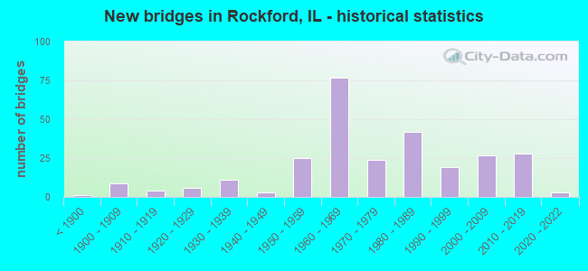
- New bridges - historical statistics
- 1Before 1900
- 91900-1909
- 41910-1919
- 61920-1929
- 111930-1939
- 31940-1949
- 251950-1959
- 771960-1969
- 241970-1979
- 421980-1989
- 191990-1999
- 272000-2009
- 282010-2019
- 32020-2022

- Reconstructed bridges - Historical Statistics
- 31950-1959
- 21960-1969
- 21970-1979
- 51980-1989
- 171990-1999
- 162000-2009
- 22010-2019


- Bridge Condition - Deck
- 3.0%Excellent
- 8.1%Very good
- 22.2%Good
- 43.0%Satisfactory
- 16.3%Fair
- 5.9%Poor
- 1.5%Serious

- Bridge Condition - Superstructure
- 2.9%Excellent
- 20.4%Very good
- 19.7%Good
- 30.7%Satisfactory
- 14.6%Fair
- 8.8%Poor
- 2.9%Serious

- Bridge Condition - Substructure
- 2.9%Excellent
- 24.1%Very good
- 35.0%Good
- 22.6%Satisfactory
- 12.4%Fair
- 2.2%Poor
- 0.7%Serious

- Bridge Condition - Channel
- 3.3%Excellent
- 20.7%Very good
- 25.0%Good
- 33.7%Satisfactory
- 13.0%Fair
- 4.3%Poor

- Bridge Condition - Culverts
- 13.1%Very good
- 31.3%Good
- 32.3%Satisfactory
- 22.2%Fair
- 1.0%Poor
Find on map >> Show street view
Structure Number: 1016029, Location: .01 N OF SPRINGBROOK (Lat: 42.304414, Lng: -89.003400), Route carried "on" structure: City street , Year Built: 1965, Status: Open, Structure Length: 0.82m (2.69ft), Average Daily Traffic: 650 (year 2017), Truck Traffic: 3%, Average Future Daily Traffic: 700 (year 2040), Design Load: HS 20, Features Intersected: SPRING CREEK, Facility Carried by Structure: SPRING LAKE DR
Minimum Vertical Clearance: 30+ m (98+ ft), Kilometerpoint: 0.547, Lanes on structure: 2, Owner: City or Municipal Highway Agency, Approaching Roadway Width: 9.1m (29.9ft), Material/Design: Concrete, Design/Construction: Culvert, Number Of Spans In Main Unit: 2, Length of Maximum Span: 4.0m (13.1ft)
Condition: Channel: Fair, Culverts: Good, Operating Rating: 40.5 metric tons, Method Used To Determine Operating Rating: Field evaluation and documented engineering judgment, Inventory Rating: 24.3 metric tons, Method Used To Determine Inventory Rating: Field evaluation and documented engineering judgment, Structural Evaluation: Equal to present minimum criteria, Waterway Adequacy: Equal to present minimum criteria, Approach Roadway Alignment: Equal to present desirable criteria, Designated Inspection Frequency: Every 24 months, Inspection Date: August 2021
Find on map >> Show street view
Structure Number: 1016031, Location: 0.07 M S SPRING CR R (Lat: 42.291231, Lng: -89.045306), Route carried "on" structure: Other road , Year Built: 1977, Status: Open, Structure Length: 1.31m (4.30ft), Average Daily Traffic: 450 (year 2017), Truck Traffic: 2%, Average Future Daily Traffic: 750 (year 2040), Design Load: HS 20, Features Intersected: SPRING CREEK, Facility Carried by Structure: BRADLEY RD
Minimum Vertical Clearance: 30+ m (98+ ft), Kilometerpoint: 1.609, Lanes on structure: 2, Owner: City or Municipal Highway Agency, Approaching Roadway Width: 9.1m (29.9ft), Skew: 2 degrees, Material/Design: Concrete, Design/Construction: Culvert, Number Of Spans In Main Unit: 3, Length of Maximum Span: 4.0m (13.1ft), Curb or Sidewalk Widths: Left: 1.4m (4.6ft), Right: 1.4m (4.6ft)
Condition: Channel: Poor, Culverts: Satisfactory, Operating Rating: 54.4 metric tons, Method Used To Determine Operating Rating: Load Factor (LF) rating reported by rating factor (RF) method using MS18 loading, Inventory Rating: 32.7 metric tons, Method Used To Determine Inventory Rating: Load Factor (LF) rating reported by rating factor (RF) method using MS18 loading, Structural Evaluation: Equal to present minimum criteria, Waterway Adequacy: Better than present minimum criteria, Approach Roadway Alignment: Better than present minimum criteria, Designated Inspection Frequency: Every 24 months, Inspection Date: September 2021
Find on map >> Show street view
Structure Number: 1016032, Location: 0.03 M S SPRING CR R (Lat: 42.292064, Lng: -89.042008), Route carried "on" structure: City street , Year Built: 1977, Status: Open, Structure Length: 1.16m (3.81ft), Average Daily Traffic: 300 (year 2017), Truck Traffic: 1%, Average Future Daily Traffic: 250 (year 2040), Design Load: HS 20, Features Intersected: SPRING CREEK, Facility Carried by Structure: EL RANCHO LN
Minimum Vertical Clearance: 30+ m (98+ ft), Kilometerpoint: 0.048, Lanes on structure: 2, Owner: City or Municipal Highway Agency, Approaching Roadway Width: 11.6m (38.1ft), Material/Design: Concrete, Design/Construction: Culvert, Number Of Spans In Main Unit: 3, Length of Maximum Span: 4.0m (13.1ft), Curb or Sidewalk Widths: Left: 1.4m (4.6ft), Right: 1.4m (4.6ft)
Condition: Channel: Satisfactory, Culverts: Good, Operating Rating: 54.1 metric tons, Method Used To Determine Operating Rating: Load Factor (LF) rating reported by rating factor (RF) method using MS18 loading, Inventory Rating: 32.4 metric tons, Method Used To Determine Inventory Rating: Load Factor (LF) rating reported by rating factor (RF) method using MS18 loading, Structural Evaluation: Better than present minimum criteria, Waterway Adequacy: Better than present minimum criteria, Approach Roadway Alignment: Equal to present minimum criteria, Designated Inspection Frequency: Every 48 months, Inspection Date: August 2021
Find on map >> Show street view
Structure Number: 1016034, Location: 0.1 M S SPRING CR RD (Lat: 42.292531, Lng: -89.040731), Route carried "on" structure: City street , Year Built: 1963, Status: Open, Structure Length: 1.13m (3.71ft), Average Daily Traffic: 100 (year 2017), Truck Traffic: 1%, Average Future Daily Traffic: 150 (year 2040), Features Intersected: SPRING CREEK, Facility Carried by Structure: EISENHOWER DRIVE
Minimum Vertical Clearance: 30+ m (98+ ft), Kilometerpoint: 0.531, Lanes on structure: 2, Owner: City or Municipal Highway Agency, Approaching Roadway Width: 8.8m (28.9ft), Skew: 3 degrees, Material/Design: Concrete, Design/Construction: Culvert, Number Of Spans In Main Unit: 3, Length of Maximum Span: 3.7m (12.1ft), Curb or Sidewalk Widths: Left: 2.3m (7.5ft), Right: 2.0m (6.6ft)
Condition: Channel: Satisfactory, Culverts: Satisfactory, Operating Rating: 40.5 metric tons, Method Used To Determine Operating Rating: Field evaluation and documented engineering judgment, Inventory Rating: 24.3 metric tons, Method Used To Determine Inventory Rating: Field evaluation and documented engineering judgment, Structural Evaluation: Equal to present minimum criteria, Waterway Adequacy: Better than present minimum criteria, Approach Roadway Alignment: Equal to present minimum criteria, Designated Inspection Frequency: Every 24 months, Inspection Date: September 2021
Find on map >> Show street view
Structure Number: 1016042, Location: 0.1 MI E KISHWAUKEE (Lat: 42.256256, Lng: -89.084578), Route carried "on" structure: City street , Year Built: 1910, Status: Posted for load, Structure Length: 1.46m (4.79ft), Average Daily Traffic: 550 (year 2017), Average Future Daily Traffic: 200 (year 2040), Features Intersected: KEITH CREEK, Facility Carried by Structure: 10TH AV
Minimum Vertical Clearance: 30+ m (98+ ft), Kilometerpoint: 0.177, Lanes on structure: 2, Owner: City or Municipal Highway Agency, Approaching Roadway Width: 10.7m (35.1ft), Material/Design: Concrete, Design/Construction: Arch - Deck, Number Of Spans In Main Unit: 1, Length of Maximum Span: 13.4m (44.0ft), Curb or Sidewalk Widths: Left: 1.7m (5.6ft), Right: 1.7m (5.6ft), Curb-To-Curb Width: 10.4m (34.1ft), Out-to-Out Width: 13.9m (45.6ft)
Condition: Superstructure: Fair, Substructure: Fair, Channel: Good, Operating Rating: 38.6 metric tons, Method Used To Determine Operating Rating: Load Factor (LF) rating reported by rating factor (RF) method using MS18 loading, Inventory Rating: 24.9 metric tons, Method Used To Determine Inventory Rating: Load Factor (LF) rating reported by rating factor (RF) method using MS18 loading, Structural Evaluation: Somewhat better than minimum adequacy, Deck Geometry: Equal to present minimum criteria, Waterway Adequacy: Better than present minimum criteria, Approach Roadway Alignment: Equal to present minimum criteria, Designated Inspection Frequency: Every 24 months, Inspection Date: July 2021
Find on map >> Show street view
Structure Number: 1016043, Location: 0.05 MI E KISHWAUKEE (Lat: 42.258417, Lng: -89.085767), Route carried "on" structure: City street , Year Built: 1919, Status: Posted for load, Structure Length: 1.01m (3.31ft), Average Daily Traffic: 650 (year 2017), Average Future Daily Traffic: 350 (year 2040), Features Intersected: KEITH CREEK, Facility Carried by Structure: 8TH AV
Minimum Vertical Clearance: 30+ m (98+ ft), Kilometerpoint: 0.080, Lanes on structure: 2, Owner: City or Municipal Highway Agency, Approaching Roadway Width: 10.4m (34.1ft), Material/Design: Concrete, Design/Construction: Slab, Number Of Spans In Main Unit: 2, Length of Maximum Span: 4.9m (16.1ft), Curb or Sidewalk Widths: Left: 2.6m (8.5ft), Right: 2.6m (8.5ft), Curb-To-Curb Width: 13.4m (44.0ft), Out-to-Out Width: 20.1m (65.9ft)
Condition: Deck: Serious, Superstructure: Serious, Substructure: Poor, Channel: Fair, Operating Rating: 5.5 metric tons, Method Used To Determine Operating Rating: Load Factor (LF) rating reported by rating factor (RF) method using MS18 loading, Inventory Rating: 3.2 metric tons, Method Used To Determine Inventory Rating: Load Factor (LF) rating reported by rating factor (RF) method using MS18 loading, Structural Evaluation: High priority of replacement, Deck Geometry: Superior to present desirable criteria, Waterway Adequacy: Better than present minimum criteria, Approach Roadway Alignment: Equal to present minimum criteria, Bridge Posting: Required (Relationship of Operating Rating to Maximum Legal Load: > 39.9% below), Length Of Structure Improvement: 1.62m (5.31ft), Designated Inspection Frequency: Every 24 months, Inspection Date: July 2021, Bridge Improvement Cost: $192,000, Roadway Improvement Cost: $19,000, Total Project Cost: $288,000, Deck Structure Type: Concrete Cast-file-Place, Wearing Surface/Protective System: Wearing Surface: Bituminous
Find on map >> Show street view
Structure Number: 1016052, Location: 0.52 N BROADWAY (Lat: 42.260661, Lng: -89.071922), Route carried "on" structure: Other road , Year Built: 1915, Year Reconstructed: 1995, Status: Open, Structure Length: 1.05m (3.44ft), Average Daily Traffic: 10,000 (year 2017), Truck Traffic: 7%, Average Future Daily Traffic: 16,900 (year 2040), Design Load: HS 20, Features Intersected: KEITH CREEK, Facility Carried by Structure: 11TH STREET
Minimum Vertical Clearance: 30+ m (98+ ft), Kilometerpoint: 0.418, Lanes on structure: 4, Base Highway Network: Yes, Owner: City or Municipal Highway Agency, Approaching Roadway Width: 14.3m (46.9ft), Material/Design: Prestressed concrete, Design/Construction: Box Beam or Girders - Multiple, Number Of Spans In Main Unit: 1, Length of Maximum Span: 10.0m (32.8ft), Curb or Sidewalk Widths: Left: 2.6m (8.5ft), Right: 2.6m (8.5ft), Curb-To-Curb Width: 14.3m (46.9ft), Out-to-Out Width: 19.5m (64.0ft)
Condition: Deck: Poor, Superstructure: Poor, Substructure: Good, Channel: Good, Operating Rating: 54.4 metric tons, Method Used To Determine Operating Rating: Load Factor (LF) rating reported by rating factor (RF) method using MS18 loading, Inventory Rating: 32.4 metric tons, Method Used To Determine Inventory Rating: Load Factor (LF) rating reported by rating factor (RF) method using MS18 loading, Structural Evaluation: Meets minimum limits, Deck Geometry: High priority of replacement, Waterway Adequacy: Equal to present desirable criteria, Approach Roadway Alignment: Equal to present desirable criteria, Designated Inspection Frequency: Every 24 months, Inspection Date: July 2021, Deck Structure Type: Concrete Precast Panels, Wearing Surface/Protective System: Wearing Surface: Bituminous, Membrane: Built-up
Find on map >> Show street view
Structure Number: 1016057, Location: 0.02 MI S CHARLES (Lat: 42.259233, Lng: -89.057589), Route carried "on" structure: Other road , Year Built: 1928, Status: Posted for load, Structure Length: 0.91m (2.99ft), Average Daily Traffic: 7,050 (year 2017), Truck Traffic: 6%, Average Future Daily Traffic: 8,100 (year 2040), Features Intersected: KEITH CREEK, Facility Carried by Structure: 20TH ST
Minimum Vertical Clearance: 30+ m (98+ ft), Kilometerpoint: 0.805, Lanes on structure: 2, Base Highway Network: Yes, Owner: City or Municipal Highway Agency, Approaching Roadway Width: 10.7m (35.1ft), Material/Design: Concrete, Design/Construction: Slab, Number Of Spans In Main Unit: 1, Length of Maximum Span: 9.1m (29.9ft), Curb or Sidewalk Widths: Left: 1.2m (3.9ft), Right: 1.2m (3.9ft), Curb-To-Curb Width: 10.4m (34.1ft), Out-to-Out Width: 19.8m (65.0ft)
Condition: Deck: Good, Superstructure: Satisfactory, Substructure: Satisfactory, Channel: Satisfactory, Operating Rating: 25.6 metric tons, Method Used To Determine Operating Rating: Load Factor (LF) rating reported by rating factor (RF) method using MS18 loading, Inventory Rating: 15.6 metric tons, Method Used To Determine Inventory Rating: Load Factor (LF) rating reported by rating factor (RF) method using MS18 loading, Structural Evaluation: High priority of corrective action, Deck Geometry: Meets minimum limits, Waterway Adequacy: Equal to present minimum criteria, Approach Roadway Alignment: Equal to present desirable criteria, Bridge Posting: Required (Relationship of Operating Rating to Maximum Legal Load: 10.0 - 19.9% below), Designated Inspection Frequency: Every 24 months, Inspection Date: October 2021, Deck Structure Type: Concrete Cast-file-Place, Wearing Surface/Protective System: Wearing Surface: Integral Concrete, Membrane: Other
Find on map >> Show street view
Structure Number: 1016058, Location: 0.6 MI S OF STATE (Lat: 42.258831, Lng: -89.080872), Route carried "on" structure: Other road , Year Built: 1986, Status: Open, Structure Length: 1.31m (4.30ft), Average Daily Traffic: 4,150 (year 2017), Truck Traffic: 6%, Average Future Daily Traffic: 3,700 (year 2040), Design Load: HS 20, Features Intersected: KEITH CREEK, Facility Carried by Structure: 7TH STREET
Minimum Vertical Clearance: 30+ m (98+ ft), Kilometerpoint: 0.885, Lanes on structure: 4, Owner: City or Municipal Highway Agency, Approaching Roadway Width: 14.6m (47.9ft), Skew: 1 degrees, Material/Design: Steel, Design/Construction: Stringer/Multi-beam, Number Of Spans In Main Unit: 1, Length of Maximum Span: 12.5m (41.0ft), Curb or Sidewalk Widths: Left: 1.5m (4.9ft), Right: 1.5m (4.9ft), Curb-To-Curb Width: 17.7m (58.1ft), Out-to-Out Width: 18.3m (60.0ft)
Condition: Deck: Good, Superstructure: Very good, Substructure: Very good, Channel: Good, Operating Rating: 44.4 metric tons, Method Used To Determine Operating Rating: Assigned rating based on Load Factor Design (LFD) reported by rating factor (RF) using MS18 loading, Inventory Rating: 32.4 metric tons, Method Used To Determine Inventory Rating: Assigned rating based on Load Factor Design (LFD) reported by rating factor (RF) using MS18 loading, Structural Evaluation: Equal to present desirable criteria, Deck Geometry: Somewhat better than minimum adequacy, Waterway Adequacy: Superior to present desirable criteria, Approach Roadway Alignment: Equal to present desirable criteria, Designated Inspection Frequency: Every 48 months, Inspection Date: August 2021, Deck Structure Type: Concrete Cast-file-Place, Wearing Surface/Protective System: Deck Protection: Epoxy Coated Reinforcing
Find on map >> Show street view
Structure Number: 1016059, Location: .01 MI N OF CHARLES (Lat: 42.259919, Lng: -89.054808), Route carried "on" structure: City street , Year Built: 1987, Status: Open, Structure Length: 0.91m (2.99ft), Average Daily Traffic: 1,950 (year 2017), Average Future Daily Traffic: 1,514 (year 2032), Design Load: HS 20, Features Intersected: KEITH CREEK, Facility Carried by Structure: HUNTER AVE
Minimum Vertical Clearance: 30+ m (98+ ft), Kilometerpoint: 0.740, Lanes on structure: 2, Owner: City or Municipal Highway Agency, Approaching Roadway Width: 9.1m (29.9ft), Material/Design: Concrete, Design/Construction: Culvert, Number Of Spans In Main Unit: 2, Length of Maximum Span: 4.3m (14.1ft)
Condition: Channel: Good, Culverts: Fair, Operating Rating: 63.2 metric tons, Method Used To Determine Operating Rating: Load Factor (LF) rating reported by rating factor (RF) method using MS18 loading, Inventory Rating: 37.9 metric tons, Method Used To Determine Inventory Rating: Load Factor (LF) rating reported by rating factor (RF) method using MS18 loading, Structural Evaluation: Somewhat better than minimum adequacy, Waterway Adequacy: Better than present minimum criteria, Approach Roadway Alignment: Equal to present desirable criteria, Designated Inspection Frequency: Every 24 months, Inspection Date: September 2021
Find on map >> Show street view
Structure Number: 101606, Location: 0.06 MI N STATE (Lat: 42.266856, Lng: -89.042417), Route carried "on" structure: Other road , Year Built: 1955, Year Reconstructed: 2012, Status: Open, Structure Length: 1.85m (6.07ft), Average Daily Traffic: 6,100 (year 2020), Truck Traffic: 3%, Average Future Daily Traffic: 8,100 (year 2040), Design Load: HS 20, Features Intersected: KEITH CREEK,NORTH BR, Facility Carried by Structure: FAIRVIEW BL
Minimum Vertical Clearance: 30+ m (98+ ft), Kilometerpoint: 2.092, Lanes on structure: 4, Base Highway Network: Yes, Owner: City or Municipal Highway Agency, Approaching Roadway Width: 15.8m (51.8ft), Skew: 3 degrees, Material/Design: Concrete continuous, Design/Construction: Slab, Number Of Spans In Main Unit: 2, Length of Maximum Span: 8.6m (28.2ft), Curb or Sidewalk Widths: Left: 2.0m (6.6ft), Right: 2.0m (6.6ft), Curb-To-Curb Width: 15.5m (50.9ft), Out-to-Out Width: 20.1m (65.9ft)
Condition: Deck: Good, Superstructure: Good, Substructure: Good, Channel: Satisfactory, Operating Rating: 45.0 metric tons, Method Used To Determine Operating Rating: Load Factor (LF) rating reported by rating factor (RF) method using MS18 loading, Inventory Rating: 26.9 metric tons, Method Used To Determine Inventory Rating: Load Factor (LF) rating reported by rating factor (RF) method using MS18 loading, Structural Evaluation: Equal to present minimum criteria, Deck Geometry: Meets minimum limits, Waterway Adequacy: Equal to present minimum criteria, Approach Roadway Alignment: Equal to present desirable criteria, Designated Inspection Frequency: Every 24 months, Inspection Date: September 2021, Deck Structure Type: Concrete Cast-file-Place, Wearing Surface/Protective System: Deck Protection: Epoxy Coated Reinforcing
Find on map >> Show street view
Structure Number: 1016061, Location: 0.03 MI E FAIRVIEW (Lat: 42.267625, Lng: -89.042003), Route carried "on" structure: Other road , Year Built: 1967, Year Reconstructed: 2010, Status: Open, Structure Length: 1.58m (5.18ft), Average Daily Traffic: 2,950 (year 2020), Truck Traffic: 4%, Average Future Daily Traffic: 4,400 (year 2040), Design Load: HS 20, Features Intersected: KEITH CREEK,NORTH BR, Facility Carried by Structure: MORSAY DR
Minimum Vertical Clearance: 30+ m (98+ ft), Kilometerpoint: 0.048, Lanes on structure: 4, Owner: City or Municipal Highway Agency, Approaching Roadway Width: 17.7m (58.1ft), Skew: 32 degrees, Material/Design: Concrete continuous, Design/Construction: Slab, Number Of Spans In Main Unit: 2, Length of Maximum Span: 7.6m (24.9ft), Curb or Sidewalk Widths: Left: 0.0m, Right: 1.5m (4.9ft), Curb-To-Curb Width: 15.8m (51.8ft), Out-to-Out Width: 19.9m (65.3ft)
Condition: Deck: Good, Superstructure: Good, Substructure: Good, Channel: Satisfactory, Operating Rating: 72.6 metric tons, Method Used To Determine Operating Rating: Load Factor (LF) rating reported by rating factor (RF) method using MS18 loading, Inventory Rating: 43.4 metric tons, Method Used To Determine Inventory Rating: Load Factor (LF) rating reported by rating factor (RF) method using MS18 loading, Structural Evaluation: Better than present minimum criteria, Deck Geometry: Meets minimum limits, Waterway Adequacy: Equal to present minimum criteria, Approach Roadway Alignment: Equal to present desirable criteria, Designated Inspection Frequency: Every 48 months, Inspection Date: September 2021, Deck Structure Type: Concrete Cast-file-Place, Wearing Surface/Protective System: Deck Protection: Epoxy Coated Reinforcing
Find on map >> Show street view
Structure Number: 1016063, Location: E. EDGE OF ROCKFORD (Lat: 42.276444, Lng: -88.960461), Route carried "on" structure: Other road , Year Built: 2017, Status: Open, Structure Length: 0.90m (2.95ft), Average Daily Traffic: 2,600 (year 2017), Truck Traffic: 6%, Average Future Daily Traffic: 13,105 (year 2038), Design Load: HS 25 or greater, Features Intersected: KEITH CREEK, Facility Carried by Structure: LYFORD RD
Minimum Vertical Clearance: 30+ m (98+ ft), Kilometerpoint: 3.122, Lanes on structure: 2, Owner: City or Municipal Highway Agency, Approaching Roadway Width: 22.1m (72.5ft), Skew: 30 degrees, Material/Design: Concrete, Design/Construction: Culvert, Number Of Spans In Main Unit: 2, Length of Maximum Span: 4.3m (14.1ft), Curb or Sidewalk Widths: Left: 1.5m (4.9ft), Right: 3.0m (9.8ft), Curb-To-Curb Width: 22.1m (72.5ft), Out-to-Out Width: 40.5m (132.9ft)
Condition: Channel: Good, Culverts: Very good, Operating Rating: 69.3 metric tons, Method Used To Determine Operating Rating: Load and Resistance Factor Rating (LRFR) rating reported by rating factor(RF) method using HL-93 loadings, Inventory Rating: 53.5 metric tons, Method Used To Determine Inventory Rating: Load and Resistance Factor Rating (LRFR) rating reported by rating factor(RF) method using HL-93 loadings, Structural Evaluation: Equal to present desirable criteria, Deck Geometry: Superior to present desirable criteria, Waterway Adequacy: Superior to present desirable criteria, Approach Roadway Alignment: Superior to present desirable criteria, Designated Inspection Frequency: Every 48 months, Inspection Date: October 2021, Deck Structure Type: Concrete Cast-file-Place
Find on map >> Show street view
Structure Number: 1016066, Location: 0.2 MI S OF E STATE (Lat: 42.260767, Lng: -89.023408), Route carried "on" structure: Other road , Year Built: 1966, Status: Open, Structure Length: 0.91m (2.99ft), Average Daily Traffic: 1,450 (year 2017), Average Future Daily Traffic: 6,400 (year 2040), Design Load: HS 15, Features Intersected: KEITH CREEK,SOUTH BR, Facility Carried by Structure: EAST LAWN DR
Minimum Vertical Clearance: 30+ m (98+ ft), Kilometerpoint: 0.338, Lanes on structure: 2, Owner: City or Municipal Highway Agency, Approaching Roadway Width: 9.1m (29.9ft), Skew: 4 degrees, Material/Design: Concrete, Design/Construction: Culvert, Number Of Spans In Main Unit: 2, Length of Maximum Span: 4.6m (15.1ft)
Condition: Channel: Fair, Culverts: Satisfactory, Operating Rating: 42.1 metric tons, Method Used To Determine Operating Rating: Load Factor (LF) rating reported by rating factor (RF) method using MS18 loading, Inventory Rating: 25.3 metric tons, Method Used To Determine Inventory Rating: Load Factor (LF) rating reported by rating factor (RF) method using MS18 loading, Structural Evaluation: Equal to present minimum criteria, Waterway Adequacy: Equal to present minimum criteria, Approach Roadway Alignment: Equal to present minimum criteria, Designated Inspection Frequency: Every 24 months, Inspection Date: August 2021
Find on map >> Show street view
Structure Number: 1016067, Location: .2 MI S CHARLES ST (Lat: 42.260008, Lng: -89.065458), Route carried "on" structure: City street , Year Built: 1996, Status: Open, Structure Length: 0.99m (3.25ft), Average Daily Traffic: 700 (year 2017), Truck Traffic: 1%, Average Future Daily Traffic: 650 (year 2040), Design Load: HS 20, Features Intersected: KEITH CREEK, Facility Carried by Structure: 15TH STREET
Minimum Vertical Clearance: 30+ m (98+ ft), Kilometerpoint: 0.257, Lanes on structure: 2, Owner: City or Municipal Highway Agency, Approaching Roadway Width: 9.1m (29.9ft), Material/Design: Concrete, Design/Construction: Channel Beam, Number Of Spans In Main Unit: 1, Length of Maximum Span: 9.1m (29.9ft), Curb or Sidewalk Widths: Left: 2.0m (6.6ft), Right: 2.0m (6.6ft), Curb-To-Curb Width: 9.1m (29.9ft), Out-to-Out Width: 13.7m (44.9ft)
Condition: Deck: Good, Superstructure: Good, Substructure: Good, Channel: Fair, Operating Rating: 49.6 metric tons, Method Used To Determine Operating Rating: Load Factor (LF) rating reported by rating factor (RF) method using MS18 loading, Inventory Rating: 29.8 metric tons, Method Used To Determine Inventory Rating: Load Factor (LF) rating reported by rating factor (RF) method using MS18 loading, Structural Evaluation: Better than present minimum criteria, Deck Geometry: Equal to present minimum criteria, Waterway Adequacy: Better than present minimum criteria, Approach Roadway Alignment: Equal to present desirable criteria, Designated Inspection Frequency: Every 48 months, Inspection Date: August 2021, Deck Structure Type: Concrete Precast Panels, Wearing Surface/Protective System: Wearing Surface: Bituminous, Membrane: Built-up
Find on map >> Show street view
Structure Number: 1016068, Location: .5 MI N OF STATE ST (Lat: 42.269936, Lng: -89.029019), Route carried "on" structure: Other road , Year Built: 2018, Status: Open, Structure Length: 1.05m (3.44ft), Average Daily Traffic: 21,200 (year 2017), Truck Traffic: 8%, Average Future Daily Traffic: 30,100 (year 2040), Design Load: HS 25 or greater, Features Intersected: BRANCH OF KEITH CRK, Facility Carried by Structure: NORTH ALPINE
Minimum Vertical Clearance: 30+ m (98+ ft), Kilometerpoint: 10.637, Lanes on structure: 4, Base Highway Network: Yes, Owner: City or Municipal Highway Agency, Approaching Roadway Width: 14.6m (47.9ft), Material/Design: Concrete, Design/Construction: Culvert, Number Of Spans In Main Unit: 3, Length of Maximum Span: 0.0m
Condition: Channel: Satisfactory, Culverts: Very good, Operating Rating: 42.1 metric tons, Method Used To Determine Operating Rating: Assigned ratings based on Load and Resistance Factor Design (LRFD) reported by rating factor (RF) using HL93 loadings, Inventory Rating: 32.4 metric tons, Method Used To Determine Inventory Rating: Assigned ratings based on Load and Resistance Factor Design (LRFD) reported by rating factor (RF) using HL93 loadings, Structural Evaluation: Equal to present desirable criteria, Waterway Adequacy: Equal to present desirable criteria, Approach Roadway Alignment: Equal to present desirable criteria, Designated Inspection Frequency: Every 48 months, Inspection Date: August 2021
Find on map >> Show street view
Structure Number: 101607, Location: 0.5 M N OF BROADWAY (Lat: 42.260131, Lng: -89.076908), Route carried "on" structure: Other road , Year Built: 1984, Status: Open, Structure Length: 1.13m (3.71ft), Average Daily Traffic: 3,150 (year 2017), Truck Traffic: 5%, Average Future Daily Traffic: 5,600 (year 2040), Design Load: HS 20, Features Intersected: KEITH CREEK, Facility Carried by Structure: 9TH STREET
Minimum Vertical Clearance: 30+ m (98+ ft), Kilometerpoint: 4.088, Lanes on structure: 4, Base Highway Network: Yes, Owner: City or Municipal Highway Agency, Approaching Roadway Width: 11.3m (37.1ft), Material/Design: Concrete, Design/Construction: Slab, Number Of Spans In Main Unit: 1, Length of Maximum Span: 10.7m (35.1ft), Curb or Sidewalk Widths: Left: 1.8m (5.9ft), Right: 1.8m (5.9ft), Curb-To-Curb Width: 15.8m (51.8ft), Out-to-Out Width: 17.7m (58.1ft)
Condition: Deck: Satisfactory, Superstructure: Satisfactory, Substructure: Good, Channel: Good, Operating Rating: 81.0 metric tons, Method Used To Determine Operating Rating: Load Factor (LF) rating reported by rating factor (RF) method using MS18 loading, Inventory Rating: 48.6 metric tons, Method Used To Determine Inventory Rating: Load Factor (LF) rating reported by rating factor (RF) method using MS18 loading, Structural Evaluation: Equal to present minimum criteria, Deck Geometry: Meets minimum limits, Waterway Adequacy: Equal to present desirable criteria, Approach Roadway Alignment: Somewhat better than minimum adequacy, Designated Inspection Frequency: Every 24 months, Inspection Date: July 2021, Deck Structure Type: Concrete Cast-file-Place
Find on map >> Show street view
Structure Number: 1016071, Location: 0.5 MI S OF E STATE (Lat: 42.259353, Lng: -89.082339), Route carried "on" structure: Other road , Year Built: 1984, Status: Open, Structure Length: 1.25m (4.10ft), Average Daily Traffic: 4,250 (year 2012), Truck Traffic: 7%, Average Future Daily Traffic: 4,800 (year 2040), Design Load: HS 20, Features Intersected: KEITH CREEK, Facility Carried by Structure: 6TH ST
Minimum Vertical Clearance: 30+ m (98+ ft), Kilometerpoint: 1.754, Lanes on structure: 2, Base Highway Network: Yes, Owner: City or Municipal Highway Agency, Approaching Roadway Width: 10.7m (35.1ft), Skew: 4 degrees, Material/Design: Concrete, Design/Construction: Slab, Number Of Spans In Main Unit: 1, Length of Maximum Span: 11.9m (39.0ft), Curb or Sidewalk Widths: Left: 1.5m (4.9ft), Right: 1.5m (4.9ft), Curb-To-Curb Width: 10.1m (33.1ft), Out-to-Out Width: 11.6m (38.1ft)
Condition: Deck: Satisfactory, Superstructure: Satisfactory, Substructure: Good, Channel: Very good, Operating Rating: 83.3 metric tons, Method Used To Determine Operating Rating: Load Factor (LF) rating reported by rating factor (RF) method using MS18 loading, Inventory Rating: 49.9 metric tons, Method Used To Determine Inventory Rating: Load Factor (LF) rating reported by rating factor (RF) method using MS18 loading, Structural Evaluation: Equal to present minimum criteria, Deck Geometry: Meets minimum limits, Waterway Adequacy: Equal to present desirable criteria, Approach Roadway Alignment: Equal to present desirable criteria, Designated Inspection Frequency: Every 24 months, Inspection Date: August 2021, Deck Structure Type: Concrete Cast-file-Place
Find on map >> Show street view
Structure Number: 1016072, Location: 0.5 MI N OF 15TH AVE (Lat: 42.256400, Lng: -89.092228), Route carried "on" structure: Other road , Year Built: 1986, Status: Closed, Structure Length: 1.68m (5.51ft), Average Daily Traffic: 3,750 (year 2020), Truck Traffic: 5%, Average Future Daily Traffic: 4,400 (year 2040), Design Load: HS 20, Features Intersected: KEITH CREEK, Facility Carried by Structure: SEMINARY ST
Minimum Vertical Clearance: 30+ m (98+ ft), Kilometerpoint: 0.724, Lanes on structure: 2, Base Highway Network: Yes, Owner: City or Municipal Highway Agency, Approaching Roadway Width: 12.2m (40.0ft), Material/Design: Prestressed concrete, Design/Construction: Box Beam or Girders - Multiple, Number Of Spans In Main Unit: 1, Length of Maximum Span: 15.8m (51.8ft), Curb or Sidewalk Widths: Left: 1.5m (4.9ft), Right: 1.5m (4.9ft), Curb-To-Curb Width: 12.2m (40.0ft), Out-to-Out Width: 15.8m (51.8ft)
Condition: Deck: Poor, Superstructure: Poor, Substructure: Poor, Channel: Satisfactory, Operating Rating: 20.4 metric tons, Method Used To Determine Operating Rating: Load Factor (LF) rating reported by rating factor (RF) method using MS18 loading, Inventory Rating: 12.3 metric tons, Method Used To Determine Inventory Rating: Load Factor (LF) rating reported by rating factor (RF) method using MS18 loading, Deck Geometry: Equal to present minimum criteria, Waterway Adequacy: Equal to present desirable criteria, Approach Roadway Alignment: Equal to present desirable criteria, Bridge Posting: Required (Relationship of Operating Rating to Maximum Legal Load: > 39.9% below), Designated Inspection Frequency: Every 24 months, Other Special Inspection Frequency: Every 6 months, Inspection Date: July 2021, Other Special Inspection Date: July 2021, Deck Structure Type: Concrete Precast Panels, Wearing Surface/Protective System: Wearing Surface: Bituminous
Find on map >> Show street view
Structure Number: 1016073, Location: 0.05 M S OF STATE ST (Lat: 42.265575, Lng: -89.042442), Route carried "on" structure: Other road , Year Built: 1986, Status: Open, Structure Length: 0.82m (2.69ft), Average Daily Traffic: 6,900 (year 2020), Truck Traffic: 4%, Average Future Daily Traffic: 7,200 (year 2040), Design Load: HS 20, Features Intersected: SO BR OF KEITH CR, Facility Carried by Structure: FAIRVIEW AVE
Minimum Vertical Clearance: 30+ m (98+ ft), Kilometerpoint: 2.221, Lanes on structure: 4, Base Highway Network: Yes, Owner: City or Municipal Highway Agency, Approaching Roadway Width: 15.2m (49.9ft), Material/Design: Concrete, Design/Construction: Culvert, Number Of Spans In Main Unit: 2, Length of Maximum Span: 3.7m (12.1ft), Curb or Sidewalk Widths: Left: 1.5m (4.9ft), Right: 1.5m (4.9ft)
Condition: Channel: Fair, Culverts: Good, Operating Rating: 59.9 metric tons, Method Used To Determine Operating Rating: Load Factor (LF) rating reported by rating factor (RF) method using MS18 loading, Inventory Rating: 36.0 metric tons, Method Used To Determine Inventory Rating: Load Factor (LF) rating reported by rating factor (RF) method using MS18 loading, Structural Evaluation: Better than present minimum criteria, Waterway Adequacy: Equal to present desirable criteria, Approach Roadway Alignment: Equal to present desirable criteria, Designated Inspection Frequency: Every 48 months, Inspection Date: August 2021
Find on map >> Show street view
Structure Number: 1016074, Location: 0.5 MI N OF 15TH AVE (Lat: 42.256400, Lng: -89.092228), Route carried "on" structure: Other road , Year Built: 2021, Status: Open, Structure Length: 2.90m (9.51ft), Average Daily Traffic: 3,750 (year 2020), Truck Traffic: 5%, Average Future Daily Traffic: 3,750 (year 2040), Design Load: HS 25 or greater, Features Intersected: KEITH CREEK, Facility Carried by Structure: SEMINARY ST
Minimum Vertical Clearance: 30+ m (98+ ft), Kilometerpoint: 0.724, Lanes on structure: 2, Base Highway Network: Yes, Owner: City or Municipal Highway Agency, Approaching Roadway Width: 12.2m (40.0ft), Skew: 1 degrees, Material/Design: Prestressed concrete, Design/Construction: Stringer/Multi-beam, Number Of Spans In Main Unit: 1, Length of Maximum Span: 0.0m, Curb or Sidewalk Widths: Left: 1.5m (4.9ft), Right: 1.5m (4.9ft), Curb-To-Curb Width: 12.2m (40.0ft), Out-to-Out Width: 15.8m (51.8ft)
Condition: Deck: Excellent, Superstructure: Excellent, Substructure: Excellent, Channel: Excellent, Operating Rating: 72.3 metric tons, Method Used To Determine Operating Rating: Load and Resistance Factor Rating (LRFR) rating reported by rating factor(RF) method using HL-93 loadings, Inventory Rating: 41.1 metric tons, Method Used To Determine Inventory Rating: Load and Resistance Factor Rating (LRFR) rating reported by rating factor(RF) method using HL-93 loadings, Structural Evaluation: Superior to present desirable criteria, Deck Geometry: Equal to present minimum criteria, Waterway Adequacy: Equal to present desirable criteria, Approach Roadway Alignment: Equal to present desirable criteria, Designated Inspection Frequency: Every 24 months, Inspection Date: November 2021, Deck Structure Type: Concrete Cast-file-Place, Wearing Surface/Protective System: Deck Protection: Epoxy Coated Reinforcing
Find on map >> Show street view
Structure Number: 1016081, Location: 0.1 MI E KISHWAUKEE (Lat: 42.224414, Lng: -89.086358), Route carried "on" structure: City street , Year Built: 1967, Status: Open, Structure Length: 0.98m (3.22ft), Average Daily Traffic: 150 (year 2017), Truck Traffic: 2%, Average Future Daily Traffic: 350 (year 2040), Design Load: HS 20, Features Intersected: S.E. DRAINAGEWAY, Facility Carried by Structure: TAFT ROAD
Minimum Vertical Clearance: 30+ m (98+ ft), Kilometerpoint: 0.048, Lanes on structure: 2, Owner: City or Municipal Highway Agency, Approaching Roadway Width: 7.3m (24.0ft), Material/Design: Concrete, Design/Construction: Culvert, Number Of Spans In Main Unit: 3, Length of Maximum Span: 3.4m (11.2ft), Curb-To-Curb Width: 12.8m (42.0ft), Out-to-Out Width: 13.2m (43.3ft)
Condition: Channel: Satisfactory, Culverts: Satisfactory, Operating Rating: 40.5 metric tons, Method Used To Determine Operating Rating: Field evaluation and documented engineering judgment, Inventory Rating: 24.3 metric tons, Method Used To Determine Inventory Rating: Field evaluation and documented engineering judgment, Structural Evaluation: Equal to present minimum criteria, Deck Geometry: Superior to present desirable criteria, Waterway Adequacy: Better than present minimum criteria, Approach Roadway Alignment: Equal to present desirable criteria, Designated Inspection Frequency: Every 24 months, Inspection Date: August 2021
Find on map >> Show street view
Structure Number: 1016082, Location: AT BROOKE AND 9TH ST (Lat: 42.230311, Lng: -89.076969), Route carried "on" structure: Other road , Year Built: 1967, Status: Open, Structure Length: 1.40m (4.59ft), Average Daily Traffic: 4,800 (year 2017), Truck Traffic: 10%, Average Future Daily Traffic: 7,600 (year 2040), Design Load: HS 20, Features Intersected: S.E. DRAINAGEWAY, Facility Carried by Structure: BROOKE AND 9TH ST
Minimum Vertical Clearance: 30+ m (98+ ft), Kilometerpoint: 0.821, Lanes on structure: 4, Owner: City or Municipal Highway Agency, Approaching Roadway Width: 11.3m (37.1ft), Skew: 4 degrees, Material/Design: Concrete, Design/Construction: Culvert, Number Of Spans In Main Unit: 3, Length of Maximum Span: 4.6m (15.1ft)
Condition: Channel: Good, Culverts: Satisfactory, Operating Rating: 37.9 metric tons, Method Used To Determine Operating Rating: Allowable Stress (AS) rating reported by rating factor (RF) method using MS18 loading, Inventory Rating: 26.2 metric tons, Method Used To Determine Inventory Rating: Allowable Stress (AS) rating reported by rating factor (RF) method using MS18 loading, Structural Evaluation: Equal to present minimum criteria, Waterway Adequacy: Equal to present minimum criteria, Approach Roadway Alignment: Equal to present desirable criteria, Designated Inspection Frequency: Every 24 months, Inspection Date: August 2021
Find on map >> Show street view
Structure Number: 1016083, Location: 0.1 MI W OF 11TH ST (Lat: 42.232469, Lng: -89.074242), Route carried "on" structure: City street , Year Built: 1967, Year Reconstructed: 2012, Status: Open, Structure Length: 1.01m (3.31ft), Average Daily Traffic: 1,450 (year 2017), Truck Traffic: 1%, Average Future Daily Traffic: 500 (year 2040), Design Load: HS 20, Features Intersected: S.E. DRAINAGEWAY, Facility Carried by Structure: REED AVE
Minimum Vertical Clearance: 30+ m (98+ ft), Kilometerpoint: 0.451, Lanes on structure: 2, Owner: City or Municipal Highway Agency, Approaching Roadway Width: 8.2m (26.9ft), Material/Design: Concrete, Design/Construction: Culvert, Number Of Spans In Main Unit: 3, Length of Maximum Span: 3.4m (11.2ft), Curb or Sidewalk Widths: Left: 2.0m (6.6ft), Right: 2.0m (6.6ft)
Condition: Channel: Good, Culverts: Satisfactory, Operating Rating: 60.9 metric tons, Method Used To Determine Operating Rating: Load Factor (LF) rating reported by rating factor (RF) method using MS18 loading, Inventory Rating: 36.3 metric tons, Method Used To Determine Inventory Rating: Load Factor (LF) rating reported by rating factor (RF) method using MS18 loading, Structural Evaluation: Equal to present minimum criteria, Waterway Adequacy: Better than present minimum criteria, Approach Roadway Alignment: Equal to present desirable criteria, Length Of Structure Improvement: 1.01m (3.31ft), Designated Inspection Frequency: Every 24 months, Inspection Date: August 2021, Bridge Improvement Cost: $90,000, Roadway Improvement Cost: $9,000, Total Project Cost: $135,000
Find on map >> Show street view
Structure Number: 1016085, Location: 0.1 MI S HARRISON AV (Lat: 42.235297, Lng: -89.069811), Route carried "on" structure: City street , Year Built: 1967, Status: Open, Structure Length: 0.98m (3.22ft), Average Daily Traffic: 1,100 (year 2017), Average Future Daily Traffic: 350 (year 2040), Design Load: HS 20, Features Intersected: S.E. DRAINAGEWAY, Facility Carried by Structure: HANSON ST
Minimum Vertical Clearance: 30+ m (98+ ft), Kilometerpoint: 0.290, Lanes on structure: 2, Owner: City or Municipal Highway Agency, Approaching Roadway Width: 7.3m (24.0ft), Skew: 2 degrees, Material/Design: Concrete, Design/Construction: Culvert, Number Of Spans In Main Unit: 3, Length of Maximum Span: 3.4m (11.2ft), Curb-To-Curb Width: 12.8m (42.0ft), Out-to-Out Width: 13.1m (43.0ft)
Condition: Channel: Good, Culverts: Good, Operating Rating: 38.9 metric tons, Method Used To Determine Operating Rating: Allowable Stress (AS) rating reported by rating factor (RF) method using MS18 loading, Inventory Rating: 27.9 metric tons, Method Used To Determine Inventory Rating: Allowable Stress (AS) rating reported by rating factor (RF) method using MS18 loading, Structural Evaluation: Better than present minimum criteria, Deck Geometry: Better than present minimum criteria, Waterway Adequacy: Better than present minimum criteria, Approach Roadway Alignment: Equal to present desirable criteria, Designated Inspection Frequency: Every 24 months, Inspection Date: August 2021
Find on map >> Show street view
Structure Number: 1016086, Location: 0.05 MI S HARRISON (Lat: 42.237217, Lng: -89.065711), Route carried "on" structure: City street , Year Built: 1966, Status: Open, Structure Length: 1.19m (3.90ft), Average Daily Traffic: 650 (year 2017), Average Future Daily Traffic: 350 (year 2040), Design Load: HS 20, Features Intersected: S.E. DRAINAGEWAY, Facility Carried by Structure: MARSHALL ST
Minimum Vertical Clearance: 30+ m (98+ ft), Kilometerpoint: 0.080, Lanes on structure: 2, Owner: City or Municipal Highway Agency, Approaching Roadway Width: 7.3m (24.0ft), Skew: 4 degrees, Material/Design: Concrete, Design/Construction: Culvert, Number Of Spans In Main Unit: 3, Length of Maximum Span: 4.0m (13.1ft), Curb-To-Curb Width: 12.8m (42.0ft), Out-to-Out Width: 13.2m (43.3ft)
Condition: Channel: Good, Culverts: Fair, Operating Rating: 38.9 metric tons, Method Used To Determine Operating Rating: Allowable Stress (AS) rating reported by rating factor (RF) method using MS18 loading, Inventory Rating: 27.9 metric tons, Method Used To Determine Inventory Rating: Allowable Stress (AS) rating reported by rating factor (RF) method using MS18 loading, Structural Evaluation: Somewhat better than minimum adequacy, Deck Geometry: Superior to present desirable criteria, Waterway Adequacy: Better than present minimum criteria, Approach Roadway Alignment: Equal to present desirable criteria, Designated Inspection Frequency: Every 24 months, Inspection Date: August 2021
Find on map >> Show street view
Structure Number: 1016092, Location: WESLEYAN AND 22ND ST (Lat: 42.245347, Lng: -89.054642), Route carried "on" structure: Other road , Year Built: 1967, Status: Open, Structure Length: 0.94m (3.08ft), Average Daily Traffic: 3,000 (year 2017), Truck Traffic: 5%, Average Future Daily Traffic: 3,200 (year 2040), Design Load: HS 20, Features Intersected: S.E. DRAINAGEWAY, Facility Carried by Structure: WESLEYAN AND 22ND
Minimum Vertical Clearance: 30+ m (98+ ft), Kilometerpoint: 0.274, Lanes on structure: 4, Owner: City or Municipal Highway Agency, Approaching Roadway Width: 9.1m (29.9ft), Skew: 6 degrees, Material/Design: Concrete, Design/Construction: Culvert, Number Of Spans In Main Unit: 2, Length of Maximum Span: 4.6m (15.1ft), Curb or Sidewalk Widths: Left: 1.5m (4.9ft), Right: 1.5m (4.9ft)
Condition: Channel: Good, Culverts: Satisfactory, Operating Rating: 40.5 metric tons, Method Used To Determine Operating Rating: Allowable Stress (AS) rating reported by rating factor (RF) method using MS18 loading, Inventory Rating: 27.9 metric tons, Method Used To Determine Inventory Rating: Allowable Stress (AS) rating reported by rating factor (RF) method using MS18 loading, Structural Evaluation: Equal to present minimum criteria, Waterway Adequacy: Better than present minimum criteria, Approach Roadway Alignment: Equal to present desirable criteria, Designated Inspection Frequency: Every 24 months, Inspection Date: August 2021
Find on map >> Show street view
Structure Number: 1016098, Location: 0.03 MI E OF 11TH ST (Lat: 42.234303, Lng: -89.071342), Route carried "on" structure: City street , Year Built: 1968, Status: Open, Structure Length: 0.94m (3.08ft), Average Daily Traffic: 850 (year 2017), Average Future Daily Traffic: 350 (year 2040), Design Load: HS 20, Features Intersected: S.E. DRAINAGEWAY, Facility Carried by Structure: WILLS AV
Minimum Vertical Clearance: 30+ m (98+ ft), Kilometerpoint: 0.708, Lanes on structure: 2, Owner: City or Municipal Highway Agency, Approaching Roadway Width: 9.1m (29.9ft), Skew: 1 degrees, Material/Design: Concrete, Design/Construction: Culvert, Number Of Spans In Main Unit: 3, Length of Maximum Span: 3.0m (9.8ft)
Condition: Channel: Good, Culverts: Fair, Operating Rating: 38.9 metric tons, Method Used To Determine Operating Rating: Allowable Stress (AS) rating reported by rating factor (RF) method using MS18 loading, Inventory Rating: 27.2 metric tons, Method Used To Determine Inventory Rating: Allowable Stress (AS) rating reported by rating factor (RF) method using MS18 loading, Structural Evaluation: Somewhat better than minimum adequacy, Waterway Adequacy: Better than present minimum criteria, Approach Roadway Alignment: Equal to present desirable criteria, Designated Inspection Frequency: Every 24 months, Inspection Date: August 2021
Find on map >> Show street view
Structure Number: 1016103, Location: 0.2 MI. N. GUILFORD (Lat: 42.284769, Lng: -89.004469), Route carried "on" structure: City street , Year Built: 2004, Status: Open, Structure Length: 0.79m (2.59ft), Average Daily Traffic: 225 (year 2017), Truck Traffic: 2%, Average Future Daily Traffic: 233 (year 2032), Design Load: HS 20, Features Intersected: KEITH CREEK, Facility Carried by Structure: COACHMAN DRIVE
Minimum Vertical Clearance: 30+ m (98+ ft), Kilometerpoint: 0.451, Lanes on structure: 2, Owner: City or Municipal Highway Agency, Approaching Roadway Width: 7.3m (24.0ft), Material/Design: Concrete, Design/Construction: Frame, Number Of Spans In Main Unit: 1, Length of Maximum Span: 7.6m (24.9ft), Curb-To-Curb Width: 7.3m (24.0ft), Out-to-Out Width: 8.3m (27.2ft)
Condition: Superstructure: Very good, Substructure: Very good, Channel: Poor, Operating Rating: 44.1 metric tons, Method Used To Determine Operating Rating: Assigned rating based on Load Factor Design (LFD) reported by rating factor (RF) using MS18 loading, Inventory Rating: 32.4 metric tons, Method Used To Determine Inventory Rating: Assigned rating based on Load Factor Design (LFD) reported by rating factor (RF) using MS18 loading, Structural Evaluation: Equal to present desirable criteria, Deck Geometry: Somewhat better than minimum adequacy, Waterway Adequacy: Equal to present desirable criteria, Approach Roadway Alignment: Equal to present desirable criteria, Designated Inspection Frequency: Every 48 months, Inspection Date: September 2019, Deck Structure Type: Other, Wearing Surface/Protective System: Wearing Surface: Bituminous, Deck Protection: Epoxy Coated Reinforcing
Find on map >> Show street view
Structure Number: 1016105, Location: .37 MI E OF 11TH ST (Lat: 42.237964, Lng: -89.065131), Route carried "on" structure: Other road , Year Built: 2016, Status: Open, Structure Length: 1.80m (5.91ft), Average Daily Traffic: 12,800 (year 2012), Truck Traffic: 8%, Average Future Daily Traffic: 15,850 (year 2035), Design Load: HS 25 or greater, Features Intersected: CONCRETE CHANNEL, Facility Carried by Structure: HARRISON AVE
Minimum Vertical Clearance: 30+ m (98+ ft), Kilometerpoint: 28.501, Lanes on structure: 4, Base Highway Network: Yes, Owner: City or Municipal Highway Agency, Approaching Roadway Width: 18.6m (61.0ft), Skew: 34 degrees, Material/Design: Concrete, Design/Construction: Culvert, Number Of Spans In Main Unit: 3, Length of Maximum Span: 6.1m (20.0ft), Curb or Sidewalk Widths: Left: 3.7m (12.1ft), Right: 0.0m, Curb-To-Curb Width: 18.6m (61.0ft), Out-to-Out Width: 25.3m (83.0ft)
Condition: Channel: Good, Culverts: Very good, Operating Rating: 53.8 metric tons, Method Used To Determine Operating Rating: Load and Resistance Factor Rating (LRFR) rating reported by rating factor(RF) method using HL-93 loadings, Inventory Rating: 41.5 metric tons, Method Used To Determine Inventory Rating: Load and Resistance Factor Rating (LRFR) rating reported by rating factor(RF) method using HL-93 loadings, Structural Evaluation: Equal to present desirable criteria, Deck Geometry: Equal to present minimum criteria, Waterway Adequacy: Better than present minimum criteria, Approach Roadway Alignment: Equal to present desirable criteria, Designated Inspection Frequency: Every 48 months, Inspection Date: October 2019, Deck Structure Type: Concrete Cast-file-Place, Wearing Surface/Protective System: Deck Protection: Epoxy Coated Reinforcing
Find on map >> Show street view
Structure Number: 1016106, Location: .21 MI W 20TH ST (Lat: 42.241939, Lng: -89.061700), Route carried "on" structure: Other road , Year Built: 2016, Status: Open, Structure Length: 1.04m (3.41ft), Average Daily Traffic: 2,800 (year 2017), Truck Traffic: 10%, Average Future Daily Traffic: 5,400 (year 2040), Design Load: HS 25 or greater, Features Intersected: DRAINAGE WAY, Facility Carried by Structure: BORG WARNER ENTRAN
Minimum Vertical Clearance: 30+ m (98+ ft), Kilometerpoint: 0.869, Lanes on structure: 2, Owner: City or Municipal Highway Agency, Approaching Roadway Width: 10.7m (35.1ft), Material/Design: Concrete, Design/Construction: Culvert, Number Of Spans In Main Unit: 3, Length of Maximum Span: 3.5m (11.5ft), Curb-To-Curb Width: 10.7m (35.1ft), Out-to-Out Width: 11.3m (37.1ft)
Condition: Channel: Very good, Culverts: Very good, Operating Rating: 69.7 metric tons, Method Used To Determine Operating Rating: Load and Resistance Factor Rating (LRFR) rating reported by rating factor(RF) method using HL-93 loadings, Inventory Rating: 53.8 metric tons, Method Used To Determine Inventory Rating: Load and Resistance Factor Rating (LRFR) rating reported by rating factor(RF) method using HL-93 loadings, Structural Evaluation: Equal to present desirable criteria, Deck Geometry: Somewhat better than minimum adequacy, Waterway Adequacy: Better than present minimum criteria, Approach Roadway Alignment: Better than present minimum criteria, Designated Inspection Frequency: Every 48 months, Inspection Date: October 2019, Deck Structure Type: Concrete Cast-file-Place, Wearing Surface/Protective System: Deck Protection: Epoxy Coated Reinforcing
Find on map >> Show street view
Structure Number: 1016107, Location: 0.7 MI S OF STATE ST (Lat: 42.269469, Lng: -89.129442), Route carried "on" structure: Other road , Year Built: 2006, Status: Open, Structure Length: 1.50m (4.92ft), Average Daily Traffic: 1,350 (year 2020), Truck Traffic: 10%, Average Future Daily Traffic: 1,600 (year 2040), Design Load: HS 20, Features Intersected: KENT CREEK, Facility Carried by Structure: HORACE AVE
Minimum Vertical Clearance: 30+ m (98+ ft), Kilometerpoint: 0.161, Lanes on structure: 2, Owner: City or Municipal Highway Agency, Approaching Roadway Width: 9.8m (32.2ft), Skew: 1 degrees, Material/Design: Concrete, Design/Construction: Culvert, Number Of Spans In Main Unit: 4, Length of Maximum Span: 3.4m (11.2ft)
Condition: Channel: Satisfactory, Culverts: Good, Operating Rating: 70.3 metric tons, Method Used To Determine Operating Rating: Load Factor (LF) rating reported by rating factor (RF) method using MS18 loading, Inventory Rating: 42.1 metric tons, Method Used To Determine Inventory Rating: Load Factor (LF) rating reported by rating factor (RF) method using MS18 loading, Structural Evaluation: Better than present minimum criteria, Waterway Adequacy: Superior to present desirable criteria, Approach Roadway Alignment: Equal to present desirable criteria, Designated Inspection Frequency: Every 48 months, Inspection Date: October 2021
Find on map >> Show street view
Structure Number: 1016108, Location: 0.3 mile E OF IL 2 (Lat: 42.261494, Lng: -89.094567), Route carried "on" structure: Other road , Year Built: 2013, Status: Open, Structure Length: 15.33m (50.30ft), Average Daily Traffic: 8,350 (year 2017), Truck Traffic: 12%, Average Future Daily Traffic: 10,035 (year 2036), Design Load: HS 25 or greater, Features Intersected: ROCK RIVER, Facility Carried by Structure: MORGAN ST
Minimum Vertical Clearance: 30+ m (98+ ft), Kilometerpoint: 4.941, Lanes on structure: 4, Base Highway Network: Yes, Owner: City or Municipal Highway Agency, Approaching Roadway Width: 15.8m (51.8ft), Navigation Control: Yes ( Vertical Clearance: 4.3m (14.1ft), Horizontal Clearance: 109.4m (358.9ft)), Material/Design: Steel, Design/Construction: Arch - Thru, Number Of Spans In Main Unit: 1, Number Of Approach Spans: 2, Length of Maximum Span: 112.7m (369.8ft), Curb or Sidewalk Widths: Left: 1.5m (4.9ft), Right: 3.7m (12.1ft), Curb-To-Curb Width: 15.8m (51.8ft), Out-to-Out Width: 22.3m (73.2ft)
Condition: Deck: Satisfactory, Superstructure: Very good, Substructure: Very good, Channel: Very good, Operating Rating: 42.1 metric tons, Method Used To Determine Operating Rating: Assigned ratings based on Load and Resistance Factor Design (LRFD) reported by rating factor (RF) using HL93 loadings, Inventory Rating: 32.4 metric tons, Method Used To Determine Inventory Rating: Assigned ratings based on Load and Resistance Factor Design (LRFD) reported by rating factor (RF) using HL93 loadings, Structural Evaluation: Equal to present desirable criteria, Deck Geometry: Meets minimum limits, Waterway Adequacy: Superior to present desirable criteria, Approach Roadway Alignment: Equal to present desirable criteria, Designated Inspection Frequency: Every 24 months, Critical Feature Inspection Frequency: Every 24 months, Inspection Date: July 2021, Critical Feature Inspection Date: July 2021, Deck Structure Type: Concrete Cast-file-Place, Wearing Surface/Protective System: Deck Protection: Epoxy Coated Reinforcing
Find on map >> Show street view
Structure Number: 1016109, Location: 1 MI E OF IL 251 (Lat: 42.237836, Lng: -89.052731), Route carried "on" structure: Other road , Year Built: 2007, Status: Open, Structure Length: 12.78m (41.93ft), Average Daily Traffic: 15,800 (year 2018), Truck Traffic: 5%, Average Future Daily Traffic: 16,100 (year 2040), Design Load: HS 20, Features Intersected: CN & UP RR, Facility Carried by Structure: HARRISON AVE W B
Minimum Vertical Clearance: 30+ m (98+ ft), Kilometerpoint: 29.531, Lanes on structure: 2, Base Highway Network: Yes, Owner: City or Municipal Highway Agency, Approaching Roadway Width: 8.5m (27.9ft), Skew: 4 degrees, Material/Design: Steel continuous, Design/Construction: Stringer/Multi-beam, Number Of Spans In Main Unit: 5, Length of Maximum Span: 31.4m (103.0ft), Curb-To-Curb Width: 8.5m (27.9ft), Out-to-Out Width: 11.2m (36.7ft)
Condition: Deck: Good, Superstructure: Very good, Substructure: Very good, Operating Rating: 58.0 metric tons, Method Used To Determine Operating Rating: Load Factor (LF) rating reported by rating factor (RF) method using MS18 loading, Inventory Rating: 34.7 metric tons, Method Used To Determine Inventory Rating: Load Factor (LF) rating reported by rating factor (RF) method using MS18 loading, Structural Evaluation: Equal to present desirable criteria, Deck Geometry: Meets minimum limits, Underclear: Superior to present desirable criteria, Approach Roadway Alignment: Equal to present desirable criteria, Designated Inspection Frequency: Every 24 months, Inspection Date: July 2021, Deck Structure Type: Concrete Cast-file-Place, Wearing Surface/Protective System: Deck Protection: Epoxy Coated Reinforcing
Find on map >> Show street view
Structure Number: 101611, Location: 0.5 MI S OF STATE ST (Lat: 42.264156, Lng: -89.099753), Route carried "on" structure: State highway 2, Year Built: 1905, Year Reconstructed: 1961, Status: Open, Structure Length: 1.89m (6.20ft), Average Daily Traffic: 8,000 (year 2021), Truck Traffic: 5%, Average Future Daily Traffic: 9,500 (year 2040), Features Intersected: KENT CREEK, Facility Carried by Structure: SOUTH MAIN ST
Minimum Vertical Clearance: 30+ m (98+ ft), Kilometerpoint: 86.741, Lanes on structure: 4, Base Highway Network: Yes, Owner: State Highway Agency, Approaching Roadway Width: 14.9m (48.9ft), Skew: 1 degrees, Material/Design: Masonry, Design/Construction: Arch - Deck, Number Of Spans In Main Unit: 2, Length of Maximum Span: 8.8m (28.9ft), Curb or Sidewalk Widths: Left: 2.1m (6.9ft), Right: 2.1m (6.9ft), Curb-To-Curb Width: 15.0m (49.2ft), Out-to-Out Width: 19.7m (64.6ft)
Condition: Deck: Good, Superstructure: Satisfactory, Substructure: Satisfactory, Channel: Satisfactory, Operating Rating: 88.8 metric tons, Method Used To Determine Operating Rating: Load Factor (LF) rating reported by rating factor (RF) method using MS18 loading, Inventory Rating: 88.8 metric tons, Method Used To Determine Inventory Rating: Load Factor (LF) rating reported by rating factor (RF) method using MS18 loading, Structural Evaluation: Equal to present minimum criteria, Deck Geometry: High priority of replacement, Waterway Adequacy: Equal to present desirable criteria, Approach Roadway Alignment: Equal to present desirable criteria, Length Of Structure Improvement: 2.65m (8.69ft), Designated Inspection Frequency: Every 24 months, Other Special Inspection Frequency: Every 6 months, Inspection Date: November 2021, Other Special Inspection Date: November 2021, Bridge Improvement Cost: $352,000, Roadway Improvement Cost: $35,000, Total Project Cost: $528,000
Find on map >> Show street view
Structure Number: 1016111, Location: 1 MI E OF IL 251 (Lat: 42.237836, Lng: -89.052325), Route carried "on" structure: Other road , Year Built: 2009, Status: Open, Structure Length: 12.78m (41.93ft), Average Daily Traffic: 15,800 (year 2018), Truck Traffic: 5%, Average Future Daily Traffic: 16,100 (year 2040), Design Load: HS 20, Features Intersected: CN & UP RR, Facility Carried by Structure: HARRISON AVE E B
Minimum Vertical Clearance: 30+ m (98+ ft), Kilometerpoint: 29.563, Lanes on structure: 2, Base Highway Network: Yes, Owner: City or Municipal Highway Agency, Approaching Roadway Width: 7.3m (24.0ft), Skew: 4 degrees, Material/Design: Steel continuous, Design/Construction: Stringer/Multi-beam, Number Of Spans In Main Unit: 5, Length of Maximum Span: 31.4m (103.0ft), Curb or Sidewalk Widths: Left: 0.0m, Right: 3.6m (11.8ft), Curb-To-Curb Width: 8.5m (27.9ft), Out-to-Out Width: 13.4m (44.0ft)
Condition: Deck: Very good, Superstructure: Very good, Substructure: Very good, Operating Rating: 59.3 metric tons, Method Used To Determine Operating Rating: Load Factor (LF) rating reported by rating factor (RF) method using MS18 loading, Inventory Rating: 35.6 metric tons, Method Used To Determine Inventory Rating: Load Factor (LF) rating reported by rating factor (RF) method using MS18 loading, Structural Evaluation: Equal to present desirable criteria, Deck Geometry: High priority of corrective action, Underclear: Superior to present desirable criteria, Approach Roadway Alignment: Equal to present desirable criteria, Designated Inspection Frequency: Every 24 months, Inspection Date: August 2021, Deck Structure Type: Concrete Cast-file-Place, Wearing Surface/Protective System: Deck Protection: Epoxy Coated Reinforcing
Find on map >> Show street view
Structure Number: 1016115, Location: 0.1 mi W. of Kilburn (Lat: 42.276319, Lng: -89.101069), Route carried "on" structure: Business US 20, Year Built: 1940, Year Reconstructed: 1995, Status: Open, Structure Length: 2.04m (6.69ft), Average Daily Traffic: 4,450 (year 2019), Truck Traffic: 3%, Average Future Daily Traffic: 3,600 (year 2040), Design Load: HS 20, Features Intersected: KENT CREEK, Facility Carried by Structure: Jefferson St
Minimum Vertical Clearance: 30+ m (98+ ft), Kilometerpoint: 30.126, Lanes on structure: 3, Base Highway Network: Yes, Owner: City or Municipal Highway Agency, Approaching Roadway Width: 12.5m (41.0ft), Material/Design: Prestressed concrete, Design/Construction: Box Beam or Girders - Multiple, Number Of Spans In Main Unit: 1, Length of Maximum Span: 19.4m (63.6ft), Curb or Sidewalk Widths: Left: 2.6m (8.5ft), Right: 2.6m (8.5ft), Curb-To-Curb Width: 12.5m (41.0ft), Out-to-Out Width: 17.7m (58.1ft)
Condition: Deck: Good, Superstructure: Good, Substructure: Very good, Channel: Good, Operating Rating: 63.5 metric tons, Method Used To Determine Operating Rating: Load Factor (LF) rating reported by rating factor (RF) method using MS18 loading, Inventory Rating: 35.3 metric tons, Method Used To Determine Inventory Rating: Load Factor (LF) rating reported by rating factor (RF) method using MS18 loading, Structural Evaluation: Better than present minimum criteria, Deck Geometry: Meets minimum limits, Waterway Adequacy: Superior to present desirable criteria, Approach Roadway Alignment: Equal to present desirable criteria, Designated Inspection Frequency: Every 48 months, Inspection Date: October 2019, Deck Structure Type: Concrete Precast Panels, Wearing Surface/Protective System: Wearing Surface: Bituminous, Membrane: Built-up
Find on map >> Show street view
Structure Number: 1016117, Location: 0.2 MI W OF KILBURN (Lat: 42.281169, Lng: -89.103219), Route carried "on" structure: Other road , Year Built: 1969, Year Reconstructed: 2003, Status: Open, Structure Length: 1.55m (5.09ft), Average Daily Traffic: 7,100 (year 2017), Truck Traffic: 8%, Average Future Daily Traffic: 10,000 (year 2040), Design Load: HS 20, Features Intersected: KENT CREEK, Facility Carried by Structure: SCHOOL ST
Minimum Vertical Clearance: 30+ m (98+ ft), Kilometerpoint: 3.460, Lanes on structure: 4, Base Highway Network: Yes, Owner: City or Municipal Highway Agency, Approaching Roadway Width: 14.3m (46.9ft), Skew: 1 degrees, Material/Design: Prestressed concrete, Design/Construction: Box Beam or Girders - Multiple, Number Of Spans In Main Unit: 1, Length of Maximum Span: 14.8m (48.6ft), Curb or Sidewalk Widths: Left: 1.7m (5.6ft), Right: 1.7m (5.6ft), Curb-To-Curb Width: 14.5m (47.6ft), Out-to-Out Width: 18.1m (59.4ft)
Condition: Deck: Satisfactory, Superstructure: Satisfactory, Substructure: Good, Channel: Good, Operating Rating: 79.1 metric tons, Method Used To Determine Operating Rating: Load Factor (LF) rating reported by rating factor (RF) method using MS18 loading, Inventory Rating: 42.8 metric tons, Method Used To Determine Inventory Rating: Load Factor (LF) rating reported by rating factor (RF) method using MS18 loading, Structural Evaluation: Equal to present minimum criteria, Deck Geometry: High priority of replacement, Waterway Adequacy: Superior to present desirable criteria, Approach Roadway Alignment: Equal to present desirable criteria, Length Of Structure Improvement: 2.16m (7.09ft), Designated Inspection Frequency: Every 24 months, Inspection Date: August 2021, Bridge Improvement Cost: $269,000, Roadway Improvement Cost: $27,000, Total Project Cost: $404,000, Deck Structure Type: Concrete Precast Panels, Wearing Surface/Protective System: Wearing Surface: Bituminous
Find on map >> Show street view
Structure Number: 101612, Location: 0.15 MI N CUNNINGHAM (Lat: 42.267789, Lng: -89.108711), Route carried "on" structure: Other road , Year Built: 1937, Year Reconstructed: 1989, Status: Open, Structure Length: 0.95m (3.12ft), Average Daily Traffic: 1,500 (year 2017), Truck Traffic: 4%, Average Future Daily Traffic: 1,600 (year 2040), Design Load: HS 20, Features Intersected: KENT CREEK, Facility Carried by Structure: CORBIN ST
Minimum Vertical Clearance: 30+ m (98+ ft), Kilometerpoint: 1.641, Lanes on structure: 2, Owner: City or Municipal Highway Agency, Approaching Roadway Width: 10.4m (34.1ft), Material/Design: Prestressed concrete, Design/Construction: Box Beam or Girders - Multiple, Number Of Spans In Main Unit: 1, Length of Maximum Span: 8.8m (28.9ft), Curb or Sidewalk Widths: Left: 1.5m (4.9ft), Right: 0.0m, Curb-To-Curb Width: 10.4m (34.1ft), Out-to-Out Width: 12.7m (41.7ft)
Condition: Deck: Serious, Superstructure: Serious, Substructure: Good, Channel: Good, Operating Rating: 74.5 metric tons, Method Used To Determine Operating Rating: Load Factor (LF) rating reported by rating factor (RF) method using MS18 loading, Inventory Rating: 44.7 metric tons, Method Used To Determine Inventory Rating: Load Factor (LF) rating reported by rating factor (RF) method using MS18 loading, Structural Evaluation: High priority of corrective action, Deck Geometry: Equal to present minimum criteria, Waterway Adequacy: Better than present minimum criteria, Approach Roadway Alignment: Equal to present minimum criteria, Designated Inspection Frequency: Every 24 months, Inspection Date: August 2021, Deck Structure Type: Concrete Precast Panels, Wearing Surface/Protective System: Wearing Surface: Bituminous, Membrane: Built-up
Find on map >> Show street view
Structure Number: 1016123, Location: 1.25 MI S OF STATE (Lat: 42.259114, Lng: -89.135139), Route carried "on" structure: Other road , Year Built: 1953, Status: Open, Structure Length: 1.13m (3.71ft), Average Daily Traffic: 850 (year 2017), Truck Traffic: 11%, Average Future Daily Traffic: 1,300 (year 2040), Design Load: H 15, Features Intersected: S. BRANCH KENT CRK., Facility Carried by Structure: PIERPONT AVE
Minimum Vertical Clearance: 30+ m (98+ ft), Kilometerpoint: 3.235, Lanes on structure: 2, Owner: City or Municipal Highway Agency, Approaching Roadway Width: 8.5m (27.9ft), Material/Design: Steel, Design/Construction: Stringer/Multi-beam, Number Of Spans In Main Unit: 1, Length of Maximum Span: 11.0m (36.1ft), Curb or Sidewalk Widths: Left: 0.6m (2.0ft), Right: 0.6m (2.0ft), Curb-To-Curb Width: 8.5m (27.9ft), Out-to-Out Width: 9.1m (29.9ft)
Condition: Deck: Very good, Superstructure: Very good, Substructure: Good, Channel: Good, Operating Rating: 36.0 metric tons, Method Used To Determine Operating Rating: Allowable Stress (AS) rating reported by rating factor (RF) method using MS18 loading, Inventory Rating: 24.3 metric tons, Method Used To Determine Inventory Rating: Allowable Stress (AS) rating reported by rating factor (RF) method using MS18 loading, Structural Evaluation: Equal to present minimum criteria, Deck Geometry: Somewhat better than minimum adequacy, Waterway Adequacy: Equal to present minimum criteria, Approach Roadway Alignment: Equal to present desirable criteria, Length Of Structure Improvement: 1.80m (5.91ft), Designated Inspection Frequency: Every 24 months, Inspection Date: July 2021, Bridge Improvement Cost: $91,000, Roadway Improvement Cost: $9,000, Total Project Cost: $137,000, Deck Structure Type: Concrete Cast-file-Place