Bridge Statistics for Rockford, Illinois (IL)
Condition, Traffic, Stress, Structural Evaluation, Project Costs
- National Bridge Inventory (NBI) Statistics
- 279Number of bridges
- 2,851ft / 869mTotal length
- $29,013,000Total costs
- 2,631,685Total average daily traffic
- 378,691Total average daily truck traffic
- National Bridge Inventory (NBI) Registered Bridges for Rockford
- No street view available for this location
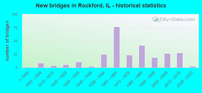
- New bridges - historical statistics
- 1Before 1900
- 91900-1909
- 41910-1919
- 61920-1929
- 111930-1939
- 31940-1949
- 251950-1959
- 771960-1969
- 241970-1979
- 421980-1989
- 191990-1999
- 272000-2009
- 282010-2019
- 32020-2022

- Reconstructed bridges - Historical Statistics
- 31950-1959
- 21960-1969
- 21970-1979
- 51980-1989
- 171990-1999
- 162000-2009
- 22010-2019


- Bridge Condition - Deck
- 3.0%Excellent
- 8.1%Very good
- 22.2%Good
- 43.0%Satisfactory
- 16.3%Fair
- 5.9%Poor
- 1.5%Serious

- Bridge Condition - Superstructure
- 2.9%Excellent
- 20.4%Very good
- 19.7%Good
- 30.7%Satisfactory
- 14.6%Fair
- 8.8%Poor
- 2.9%Serious

- Bridge Condition - Substructure
- 2.9%Excellent
- 24.1%Very good
- 35.0%Good
- 22.6%Satisfactory
- 12.4%Fair
- 2.2%Poor
- 0.7%Serious

- Bridge Condition - Channel
- 3.3%Excellent
- 20.7%Very good
- 25.0%Good
- 33.7%Satisfactory
- 13.0%Fair
- 4.3%Poor

- Bridge Condition - Culverts
- 13.1%Very good
- 31.3%Good
- 32.3%Satisfactory
- 22.2%Fair
- 1.0%Poor
Find on map >> Show street view
Structure Number: 1010065, Location: S EDGE ROCKFORD (Lat: 42.219383, Lng: -89.072392), Route carried "under" structure: State highway 251, Year Built: 1960, Structure Length: 0. m, Average Daily Traffic: 20,400 (year 2021), Truck Traffic: 10%, Features Intersected: ILL 251 (11TH ST), Facility Carried by Structure: US 20 E B
Minimum Vertical Clearance: 4.55m (14.93ft), Kilometerpoint: 183.090, Lanes on structure: 2, Lanes under structure: 4, Material/Design: Steel, Design/Construction: Stringer/Multi-beam, Length of Maximum Span: 22.3m (73.2ft)
Find on map >> Show street view
Structure Number: 1010066, Location: S EDGE ROCKFORD (Lat: 42.219642, Lng: -89.072392), Route carried "under" structure: State highway 251, Year Built: 1960, Structure Length: 0. m, Average Daily Traffic: 19,000 (year 2021), Truck Traffic: 8%, Features Intersected: ILL 251 (11TH ST), Facility Carried by Structure: US 20 W B
Minimum Vertical Clearance: 4.52m (14.83ft), Kilometerpoint: 183.122, Lanes on structure: 2, Lanes under structure: 4, Material/Design: Steel, Design/Construction: Stringer/Multi-beam, Length of Maximum Span: 22.3m (73.2ft)
Find on map >> Show street view
Structure Number: 1010094, Location: 1.5 MI E MERIDIAN RD (Lat: 42.244889, Lng: -89.141169), Route carried "under" structure: US 20, Year Built: 1964, Structure Length: 0. m, Average Daily Traffic: 20,900 (year 2021), Truck Traffic: 14%, Features Intersected: US RT 20, Facility Carried by Structure: MONTAGUE RD
Minimum Vertical Clearance: 4.75m (15.58ft), Kilometerpoint: 145.127, Lanes on structure: 2, Lanes under structure: 4, Material/Design: Steel continuous, Design/Construction: Stringer/Multi-beam, Length of Maximum Span: 17.2m (56.4ft)
Find on map >> Show street view
Structure Number: 1010096, Location: 1 MI S OF RT 20BR (Lat: 42.266247, Lng: -89.173572), Route carried "under" structure: US 20, Year Built: 1964, Structure Length: 0. m, Average Daily Traffic: 15,500 (year 2021), Truck Traffic: 15%, Features Intersected: US RT 20, Facility Carried by Structure: MERIDIAN RD
Minimum Vertical Clearance: 4.95m (16.24ft), Kilometerpoint: 141.168, Lanes on structure: 2, Lanes under structure: 4, Material/Design: Steel continuous, Design/Construction: Stringer/Multi-beam, Length of Maximum Span: 17.8m (58.4ft)
Find on map >> Show street view
Structure Number: 1010131, Location: .5 MI E OF US 51 (Lat: 42.220061, Lng: -88.998789), Route carried "under" structure: Interstate 39, Year Built: 1976, Structure Length: 0. m, Average Daily Traffic: 52,200 (year 2021), Truck Traffic: 26%, Features Intersected: I-39 & US 20, Facility Carried by Structure: MULFORD RD
Minimum Vertical Clearance: 4.85m (15.91ft), Kilometerpoint: 193.985, Lanes on structure: 2, Lanes under structure: 4, Material/Design: Steel continuous, Design/Construction: Stringer/Multi-beam, Length of Maximum Span: 39.9m (130.9ft)
Find on map >> Show street view
Structure Number: 1010135, Location: SW EDGE OF ROCKFORD (Lat: 42.220111, Lng: -89.011725), Route carried "under" structure: US 20, Year Built: 1981, Structure Length: 0. m, Average Daily Traffic: 30,800 (year 2021), Truck Traffic: 19%, Features Intersected: US 20 BYPASS, Facility Carried by Structure: I-39 OFF RAMP
Minimum Vertical Clearance: 4.95m (16.24ft), Kilometerpoint: 157.390, Lanes on structure: 1, Lanes under structure: 4, Material/Design: Steel continuous, Design/Construction: Stringer/Multi-beam, Length of Maximum Span: 30.2m (99.1ft)
Find on map >> Show street view
Structure Number: 1010136, Location: 0.4 MI W OF MULFORD (Lat: 42.220100, Lng: -89.006769), Route carried "under" structure: US 20, Year Built: 1981, Structure Length: 0. m, Average Daily Traffic: 30,800 (year 2021), Truck Traffic: 19%, Features Intersected: FAP 301(US20 BYPASS), Facility Carried by Structure: I-39 SB
Minimum Vertical Clearance: 5.41m (17.75ft), Kilometerpoint: 158.033, Lanes on structure: 1, Lanes under structure: 4, Material/Design: Steel continuous, Design/Construction: Stringer/Multi-beam, Length of Maximum Span: 47.2m (154.9ft)
Find on map >> Show street view
Structure Number: 1010137, Location: .25 MI S OF US20 (Lat: 42.216831, Lng: -89.014519), Route carried "under" structure: Other road , Year Built: 1981, Structure Length: 0. m, Average Daily Traffic: 6,350 (year 2017), Truck Traffic: 4%, Features Intersected: LINDEN ROAD, Facility Carried by Structure: I-39 RAMP
Minimum Vertical Clearance: 4.34m (14.24ft), Kilometerpoint: 1.143, Lanes on structure: 1, Lanes under structure: 2, Material/Design: Steel, Design/Construction: Stringer/Multi-beam, Length of Maximum Span: 26.8m (87.9ft)
Find on map >> Show street view
Structure Number: 1010138, Location: 0.25 MI S OF US 20 (Lat: 42.216869, Lng: -89.011250), Route carried "under" structure: Other road , Year Built: 1981, Structure Length: 0. m, Average Daily Traffic: 6,350 (year 2017), Truck Traffic: 4%, Features Intersected: LINDEN RD, Facility Carried by Structure: I-39 RAMP
Minimum Vertical Clearance: 5.79m (19.00ft), Kilometerpoint: 1.416, Lanes on structure: 1, Lanes under structure: 2, Material/Design: Steel, Design/Construction: Stringer/Multi-beam, Length of Maximum Span: 26.2m (86.0ft)
Find on map >> Show street view
Structure Number: 1010139, Location: 0.25 MI S OF US 20 (Lat: 42.216903, Lng: -89.009767), Route carried "under" structure: Other road , Year Built: 1981, Structure Length: 0. m, Average Daily Traffic: 6,350 (year 2017), Truck Traffic: 4%, Features Intersected: LINDEN ROAD, Facility Carried by Structure: I-39 SB
Minimum Vertical Clearance: 4.45m (14.60ft), Kilometerpoint: 1.513, Lanes on structure: 1, Lanes under structure: 2, Material/Design: Steel, Design/Construction: Stringer/Multi-beam, Length of Maximum Span: 31.4m (103.0ft)
Find on map >> Show street view
Structure Number: 101014, Location: 0.25 MI S OF US 20 (Lat: 42.216911, Lng: -89.009161), Route carried "under" structure: Other road , Year Built: 1981, Structure Length: 0. m, Average Daily Traffic: 6,350 (year 2017), Truck Traffic: 4%, Features Intersected: LINDEN ROAD, Facility Carried by Structure: I-39 NB
Minimum Vertical Clearance: 4.45m (14.60ft), Kilometerpoint: 1.545, Lanes on structure: 1, Lanes under structure: 2, Material/Design: Steel, Design/Construction: Stringer/Multi-beam, Length of Maximum Span: 31.4m (103.0ft)
Find on map >> Show street view
Structure Number: 1010141, Location: 0.35 MI S OF US 20 (Lat: 42.214469, Lng: -89.011000), Route carried "under" structure: Interstate 39, Year Built: 1981, Structure Length: 0. m, Average Daily Traffic: 24,100 (year 2021), Truck Traffic: 37%, Features Intersected: I-39 & US 51 SB
Minimum Vertical Clearance: 4.98m (16.34ft), Kilometerpoint: 192.714, Lanes on structure: 1, Lanes under structure: 1, Material/Design: Steel, Design/Construction: Stringer/Multi-beam, Length of Maximum Span: 48.5m (159.1ft)
Find on map >> Show street view
Structure Number: 1010142, Location: 1.75 MI S OF US 20 (Lat: 42.194939, Lng: -89.023719), Route carried "under" structure: Other road , Year Built: 1981, Structure Length: 0. m, Average Daily Traffic: 3,400 (year 2020), Truck Traffic: 7%, Features Intersected: BLACKHAWK RD, Facility Carried by Structure: I-39 & US 51 SB
Minimum Vertical Clearance: 5.03m (16.50ft), Kilometerpoint: 5.182, Lanes on structure: 2, Lanes under structure: 2, Material/Design: Steel, Design/Construction: Stringer/Multi-beam, Length of Maximum Span: 26.5m (86.9ft)
Find on map >> Show street view
Structure Number: 1010143, Location: 1.75 MI S OF US 20 (Lat: 42.194944, Lng: -89.023381), Route carried "under" structure: Other road , Year Built: 1981, Structure Length: 0. m, Average Daily Traffic: 3,400 (year 2020), Truck Traffic: 7%, Features Intersected: BLACKHAWK ROAD, Facility Carried by Structure: I-39 & US 51 NB
Minimum Vertical Clearance: 4.45m (14.60ft), Kilometerpoint: 5.214, Lanes on structure: 2, Lanes under structure: 2, Material/Design: Steel, Design/Construction: Stringer/Multi-beam, Length of Maximum Span: 26.4m (86.6ft)
Find on map >> Show street view
Structure Number: 1010151, Location: SOUTH EDGE ROCKFORD (Lat: 42.219883, Lng: -89.028758), Route carried "under" structure: US 20, Year Built: 1984, Structure Length: 0. m, Average Daily Traffic: 33,100 (year 2021), Truck Traffic: 18%, Features Intersected: US 20 BY-PASS, Facility Carried by Structure: ALPINE ROAD
Minimum Vertical Clearance: 4.83m (15.85ft), Kilometerpoint: 155.957, Lanes on structure: 4, Lanes under structure: 4, Material/Design: Prestressed concrete continuous, Design/Construction: Stringer/Multi-beam, Length of Maximum Span: 24.9m (81.7ft)
Find on map >> Show street view
Structure Number: 1010186, Location: 1 MI S OF ROCKFORD (Lat: 42.219322, Lng: -89.108917), Route carried "under" structure: State highway 2, Year Built: 2019, Structure Length: 0. m, Average Daily Traffic: 14,600 (year 2021), Truck Traffic: 10%, Features Intersected: ILL 2
Minimum Vertical Clearance: 5.31m (17.42ft), Kilometerpoint: 81.592, Lanes on structure: 2, Lanes under structure: 4, Material/Design: Prestressed concrete continuous, Design/Construction: Stringer/Multi-beam, Length of Maximum Span: 35.4m (116.1ft)
Find on map >> Show street view
Structure Number: 1010187, Location: 1 MI S OF ROCKFORD (Lat: 42.219500, Lng: -89.108917), Route carried "under" structure: State highway 2, Year Built: 2019, Structure Length: 0. m, Average Daily Traffic: 14,600 (year 2021), Truck Traffic: 10%, Features Intersected: ILL 2
Minimum Vertical Clearance: 30+ m (98+ ft), Kilometerpoint: 81.624, Lanes on structure: 2, Lanes under structure: 4, Material/Design: Prestressed concrete continuous, Design/Construction: Stringer/Multi-beam, Length of Maximum Span: 35.4m (116.1ft)
Find on map >> Show street view
Structure Number: 1010188, Location: 0.7 MI E OF ILL 251 (Lat: 42.219531, Lng: -89.057550), Route carried "under" structure: US 20, Year Built: 2021, Structure Length: 0. m, Average Daily Traffic: 34,500 (year 2021), Truck Traffic: 16%, Features Intersected: US 20
Minimum Vertical Clearance: 30+ m (98+ ft), Kilometerpoint: 153.575, Lanes on structure: 2, Lanes under structure: 4, Material/Design: Steel continuous, Design/Construction: Stringer/Multi-beam, Length of Maximum Span: 33.2m (108.9ft)
Find on map >> Show street view
Structure Number: 101019, Location: 1.4 MI N WHITMAN ST (Lat: 42.288664, Lng: -89.061097), Route carried "under" structure: Other road , Year Built: 2012, Structure Length: 0. m, Average Daily Traffic: 27,800 (year 2018), Truck Traffic: 4%, Features Intersected: SPRING CREEK RD, Facility Carried by Structure: ILL 251
Minimum Vertical Clearance: 4.88m (16.01ft), Kilometerpoint: 1.545, Lanes on structure: 8, Lanes under structure: 6, Material/Design: Steel continuous, Design/Construction: Stringer/Multi-beam, Length of Maximum Span: 21.5m (70.5ft)
Find on map >> Show street view
Structure Number: 1016135, Location: 0.1 MI E OF N MAIN (Lat: 42.270700, Lng: -89.088431), Route carried "under" structure: Other road , Year Built: 1925, Structure Length: 0. m, Average Daily Traffic: 3,250 (year 2020), Truck Traffic: 6%, Features Intersected: ROCK RIV& MADISON ST, Facility Carried by Structure: JEFFERSON ST
Minimum Vertical Clearance: 4.57m (14.99ft), Kilometerpoint: 1.030, Lanes on structure: 4, Lanes under structure: 2, Material/Design: Concrete, Length of Maximum Span: 32.3m (106.0ft)
Find on map >> Show street view
Structure Number: 1016135, Location: 0.1 MI E OF N MAIN (Lat: 42.271256, Lng: -89.089578), Route carried "under" structure: City street , Year Built: 1925, Structure Length: 0. m, Average Daily Traffic: 375 (year 2017), Truck Traffic: 6%, Features Intersected: ROCK RIV& MADISON ST, Facility Carried by Structure: JEFFERSON ST
Minimum Vertical Clearance: 4.57m (14.99ft), Kilometerpoint: 0.016, Lanes on structure: 4, Lanes under structure: 2, Material/Design: Concrete, Length of Maximum Span: 32.3m (106.0ft)
Find on map >> Show street view
Structure Number: 10162, Location: 0.25 MI E OF MAIN ST (Lat: 42.276869, Lng: -89.083044), Route carried "under" structure: Other road , Year Built: 1961, Structure Length: 0. m, Average Daily Traffic: 3,500 (year 2017), Truck Traffic: 5%, Features Intersected: MADISON ST & RR, Facility Carried by Structure: WHITMAN ST
Minimum Vertical Clearance: 7.01m (23.00ft), Kilometerpoint: 0.209, Lanes on structure: 4, Lanes under structure: 4, Material/Design: Steel, Design/Construction: Stringer/Multi-beam, Length of Maximum Span: 20.4m (66.9ft)
Find on map >> Show street view
Structure Number: 1016201, Location: WHITMAN INTERCHANGE (Lat: 42.275133, Lng: -89.080697), Route carried "under" structure: State highway 251, Year Built: 1963, Structure Length: 0. m, Average Daily Traffic: 7,200 (year 2021), Truck Traffic: 5%, Features Intersected: WHITMAN ST, Facility Carried by Structure: N 2ND ST
Minimum Vertical Clearance: 5.77m (18.93ft), Kilometerpoint: 190.734, Lanes on structure: 4, Lanes under structure: 4, Material/Design: Steel, Design/Construction: Stringer/Multi-beam, Length of Maximum Span: 28.7m (94.2ft)
Find on map >> Show street view
Structure Number: 1016202, Location: WHITMAN INTERCHANGE (Lat: 42.272769, Lng: -89.081919), Route carried "under" structure: Other road , Year Built: 1963, Structure Length: 0. m, Average Daily Traffic: 4,700 (year 2015), Truck Traffic: 10%, Features Intersected: SB RAMP TO N 6TH ST, Facility Carried by Structure: N 3RD ST EXT TO 2N
Minimum Vertical Clearance: 4.72m (15.49ft), Kilometerpoint: 0.306, Lanes on structure: 2, Lanes under structure: 1, Material/Design: Steel continuous, Design/Construction: Stringer/Multi-beam, Length of Maximum Span: 26.5m (86.9ft)
Find on map >> Show street view
Structure Number: 1019911, Location: .25 MI N OF 20 BR (Lat: 42.275422, Lng: -88.964975), Route carried "under" structure: Interstate 39, Year Built: 1958, Structure Length: 0. m, Average Daily Traffic: 58,600 (year 2020), Truck Traffic: 29%, Features Intersected: I-90, Facility Carried by Structure: I-90 RAMP
Minimum Vertical Clearance: 4.65m (15.26ft), Kilometerpoint: 200.454, Lanes on structure: 2, Lanes under structure: 4, Toll: On toll road, Material/Design: Prestressed concrete, Design/Construction: Stringer/Multi-beam, Length of Maximum Span: 23.8m (78.1ft)
Find on map >> Show street view
Structure Number: 1019916, Location: 2 MI N RT 20 BR (Lat: 42.304539, Lng: -88.964839), Route carried "under" structure: Interstate 39, Year Built: 1958, Structure Length: 0. m, Average Daily Traffic: 53,700 (year 2020), Truck Traffic: 34%, Features Intersected: I-90, Facility Carried by Structure: SPRING CREEK RD
Minimum Vertical Clearance: 4.65m (15.26ft), Kilometerpoint: 203.689, Lanes on structure: 2, Lanes under structure: 4, Material/Design: Prestressed concrete, Design/Construction: Stringer/Multi-beam, Length of Maximum Span: 19.5m (64.0ft)
Find on map >> Show street view
Structure Number: 1019923, Location: 2 MI E ROCKFORD (Lat: 42.289969, Lng: -88.964928), Route carried "under" structure: Interstate 39, Year Built: 1958, Structure Length: 0. m, Average Daily Traffic: 53,700 (year 2020), Truck Traffic: 34%, Features Intersected: I-90, Facility Carried by Structure: ROTE RD
Minimum Vertical Clearance: 4.62m (15.16ft), Kilometerpoint: 202.064, Lanes on structure: 2, Lanes under structure: 4, Material/Design: Prestressed concrete, Design/Construction: Stringer/Multi-beam, Length of Maximum Span: 19.5m (64.0ft)
Find on map >> Show street view
Structure Number: 1019925, Location: S EDGE RKFD CBD (Lat: 42.266683, Lng: -89.097886), Route carried "under" structure: State highway 2, Year Built: 1900, Structure Length: 0. m, Average Daily Traffic: 8,000 (year 2021), Truck Traffic: 5%, Features Intersected: ILL 2, Facility Carried by Structure: UNION PACIFIC RR
Minimum Vertical Clearance: 4.34m (14.24ft), Kilometerpoint: 87.095, Lanes under structure: 4, Material/Design: Steel, Design/Construction: Girder and Floorbeam System, Length of Maximum Span: 21.3m (69.9ft)
Find on map >> Show street view
Structure Number: 1019934, Location: SW ROCKFORD (Lat: 42.268625, Lng: -89.109400), Route carried "under" structure: City street , Year Built: 1900, Structure Length: 0. m, Average Daily Traffic: 750 (year 2017), Truck Traffic: 1%, Features Intersected: TAY ST & KENT CREEK, Facility Carried by Structure: UNION PACIFIC RR
Minimum Vertical Clearance: 4.57m (14.99ft), Kilometerpoint: 0.805, Lanes under structure: 2, Material/Design: Steel, Design/Construction: Girder and Floorbeam System, Length of Maximum Span: 24.4m (80.1ft)
Find on map >> Show street view
Structure Number: 1019939, Location: SE ROCKFORD (Lat: 42.258369, Lng: -89.076900), Route carried "under" structure: Other road , Year Built: 1890, Structure Length: 0. m, Average Daily Traffic: 3,150 (year 2017), Truck Traffic: 5%, Features Intersected: 9TH STREET, Facility Carried by Structure: UP RR
Minimum Vertical Clearance: 4.57m (14.99ft), Kilometerpoint: 3.878, Lanes under structure: 2, Material/Design: Steel, Design/Construction: Girder and Floorbeam System, Length of Maximum Span: 12.2m (40.0ft)
Find on map >> Show street view
Structure Number: 101994, Location: SE ROCKFORD (Lat: 42.252467, Lng: -89.063967), Route carried "under" structure: Other road , Year Built: 1900, Structure Length: 0. m, Average Daily Traffic: 9,900 (year 2017), Truck Traffic: 8%, Features Intersected: BROADWAY, Facility Carried by Structure: UNION PACIFIC RR
Minimum Vertical Clearance: 4.42m (14.50ft), Kilometerpoint: 1.867, Lanes under structure: 2, Material/Design: Steel, Design/Construction: Girder and Floorbeam System, Length of Maximum Span: 9.8m (32.2ft)
Find on map >> Show street view
Structure Number: 1019941, Location: SE ROCKFORD (Lat: 42.243769, Lng: -89.057353), Route carried "under" structure: Other road , Year Built: 1900, Structure Length: 0. m, Average Daily Traffic: 8,950 (year 2012), Truck Traffic: 2%, Features Intersected: 20TH STREET, Facility Carried by Structure: UP RR
Minimum Vertical Clearance: 3.56m (11.68ft), Kilometerpoint: 2.591, Lanes under structure: 1, Material/Design: Steel, Design/Construction: Girder and Floorbeam System, Length of Maximum Span: 7.3m (24.0ft)
Find on map >> Show street view
Structure Number: 1019943, Location: 2 MI E LOVES PARK (Lat: 42.319100, Lng: -88.964669), Route carried "under" structure: Interstate 39, Year Built: 2009, Structure Length: 0. m, Average Daily Traffic: 53,700 (year 2020), Truck Traffic: 34%, Features Intersected: I-90, Facility Carried by Structure: RIVERSIDE RD
Minimum Vertical Clearance: 4.65m (15.26ft), Kilometerpoint: 205.298, Lanes on structure: 2, Lanes under structure: 6, Material/Design: Steel continuous, Design/Construction: Stringer/Multi-beam, Length of Maximum Span: 35.1m (115.2ft)
Find on map >> Show street view
Structure Number: 1019968, Location: 2 MI E ROCKFORD (Lat: 42.270992, Lng: -88.964697), Route carried "under" structure: Business US 20, Year Built: 2009, Structure Length: 0. m, Average Daily Traffic: 28,000 (year 2019), Truck Traffic: 4%, Features Intersected: US 20 BR, Facility Carried by Structure: I-90 N B
Minimum Vertical Clearance: 4.83m (15.85ft), Kilometerpoint: 38.253, Lanes on structure: 3, Lanes under structure: 4, Toll: On toll road, Material/Design: Prestressed concrete, Design/Construction: Stringer/Multi-beam, Length of Maximum Span: 25.6m (84.0ft)
Find on map >> Show street view
Structure Number: 1019969, Location: 1.2M W OF NEWBURG RD (Lat: 42.270967, Lng: -88.964950), Route carried "under" structure: Business US 20, Year Built: 2009, Structure Length: 0. m, Average Daily Traffic: 28,000 (year 2019), Truck Traffic: 4%, Features Intersected: US 20 BR, Facility Carried by Structure: I-90 S B
Minimum Vertical Clearance: 4.65m (15.26ft), Kilometerpoint: 38.221, Lanes on structure: 3, Lanes under structure: 4, Toll: On toll road, Material/Design: Prestressed concrete, Design/Construction: Stringer/Multi-beam, Length of Maximum Span: 25.6m (84.0ft)