Bridge Statistics for Rockford, Illinois (IL)
Condition, Traffic, Stress, Structural Evaluation, Project Costs
- National Bridge Inventory (NBI) Statistics
- 279Number of bridges
- 2,851ft / 869mTotal length
- $29,013,000Total costs
- 2,631,685Total average daily traffic
- 378,691Total average daily truck traffic
- National Bridge Inventory (NBI) Registered Bridges for Rockford
- No street view available for this location
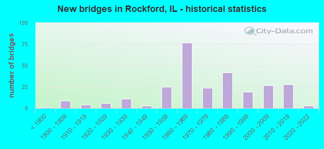
- New bridges - historical statistics
- 1Before 1900
- 91900-1909
- 41910-1919
- 61920-1929
- 111930-1939
- 31940-1949
- 251950-1959
- 771960-1969
- 241970-1979
- 421980-1989
- 191990-1999
- 272000-2009
- 282010-2019
- 32020-2022

- Reconstructed bridges - Historical Statistics
- 31950-1959
- 21960-1969
- 21970-1979
- 51980-1989
- 171990-1999
- 162000-2009
- 22010-2019


- Bridge Condition - Deck
- 3.0%Excellent
- 8.1%Very good
- 22.2%Good
- 43.0%Satisfactory
- 16.3%Fair
- 5.9%Poor
- 1.5%Serious

- Bridge Condition - Superstructure
- 2.9%Excellent
- 20.4%Very good
- 19.7%Good
- 30.7%Satisfactory
- 14.6%Fair
- 8.8%Poor
- 2.9%Serious

- Bridge Condition - Substructure
- 2.9%Excellent
- 24.1%Very good
- 35.0%Good
- 22.6%Satisfactory
- 12.4%Fair
- 2.2%Poor
- 0.7%Serious

- Bridge Condition - Channel
- 3.3%Excellent
- 20.7%Very good
- 25.0%Good
- 33.7%Satisfactory
- 13.0%Fair
- 4.3%Poor

- Bridge Condition - Culverts
- 13.1%Very good
- 31.3%Good
- 32.3%Satisfactory
- 22.2%Fair
- 1.0%Poor
Find on map >> Show street view
Structure Number: 1016124, Location: 0.06 MI S OF PRESTON (Lat: 42.271108, Lng: -89.116072), Route carried "on" structure: Other road , Year Built: 1975, Year Reconstructed: 2011, Status: Open, Structure Length: 2.26m (7.41ft), Average Daily Traffic: 3,800 (year 2020), Truck Traffic: 8%, Average Future Daily Traffic: 5,300 (year 2040), Design Load: HS 20, Features Intersected: S. BR. OF KENT CREEK, Facility Carried by Structure: S. CENTRAL AVENUE
Minimum Vertical Clearance: 30+ m (98+ ft), Kilometerpoint: 7.065, Lanes on structure: 2, Base Highway Network: Yes, Owner: City or Municipal Highway Agency, Approaching Roadway Width: 9.1m (29.9ft), Skew: 1 degrees, Material/Design: Concrete, Design/Construction: Slab, Number Of Spans In Main Unit: 3, Length of Maximum Span: 8.5m (27.9ft), Curb or Sidewalk Widths: Left: 0.0m, Right: 1.5m (4.9ft), Curb-To-Curb Width: 9.8m (32.2ft), Out-to-Out Width: 11.9m (39.0ft)
Condition: Deck: Good, Superstructure: Good, Substructure: Good, Channel: Very good, Operating Rating: 59.6 metric tons, Method Used To Determine Operating Rating: Load Factor (LF) rating reported by rating factor (RF) method using MS18 loading, Inventory Rating: 35.6 metric tons, Method Used To Determine Inventory Rating: Load Factor (LF) rating reported by rating factor (RF) method using MS18 loading, Structural Evaluation: Better than present minimum criteria, Deck Geometry: Meets minimum limits, Waterway Adequacy: Equal to present desirable criteria, Approach Roadway Alignment: Equal to present desirable criteria, Designated Inspection Frequency: Every 48 months, Inspection Date: October 2019, Deck Structure Type: Concrete Cast-file-Place, Wearing Surface/Protective System: Deck Protection: Epoxy Coated Reinforcing
Find on map >> Show street view
Structure Number: 1016125, Location: 0.1 MI S OF PRESTON (Lat: 42.270736, Lng: -89.117764), Route carried "on" structure: City street , Year Built: 1978, Year Reconstructed: 2010, Status: Open, Structure Length: 1.62m (5.31ft), Average Daily Traffic: 650 (year 2017), Truck Traffic: 18%, Average Future Daily Traffic: 350 (year 2040), Design Load: HS 25 or greater, Features Intersected: S BR KENT CREEK, Facility Carried by Structure: INDEPENDENCE AVE
Minimum Vertical Clearance: 30+ m (98+ ft), Kilometerpoint: 0.628, Lanes on structure: 2, Owner: City or Municipal Highway Agency, Approaching Roadway Width: 9.7m (31.8ft), Material/Design: Concrete, Design/Construction: Slab, Number Of Spans In Main Unit: 3, Length of Maximum Span: 7.9m (25.9ft), Curb or Sidewalk Widths: Left: 0.0m, Right: 1.5m (4.9ft), Curb-To-Curb Width: 9.6m (31.5ft), Out-to-Out Width: 11.9m (39.0ft)
Condition: Deck: Satisfactory, Superstructure: Satisfactory, Substructure: Very good, Channel: Good, Operating Rating: 53.8 metric tons, Method Used To Determine Operating Rating: Load Factor (LF) rating reported by rating factor (RF) method using MS18 loading, Inventory Rating: 36.0 metric tons, Method Used To Determine Inventory Rating: Load Factor (LF) rating reported by rating factor (RF) method using MS18 loading, Structural Evaluation: Equal to present minimum criteria, Deck Geometry: Equal to present minimum criteria, Waterway Adequacy: Superior to present desirable criteria, Approach Roadway Alignment: Equal to present desirable criteria, Length Of Structure Improvement: 1.62m (5.31ft), Designated Inspection Frequency: Every 24 months, Inspection Date: August 2021, Bridge Improvement Cost: $129,000, Roadway Improvement Cost: $13,000, Total Project Cost: $194,000, Deck Structure Type: Concrete Cast-file-Place, Wearing Surface/Protective System: Deck Protection: Epoxy Coated Reinforcing
Find on map >> Show street view
Structure Number: 1016126, Location: 0.4 MI S OF STATE ST (Lat: 42.267183, Lng: -89.102600), Route carried "on" structure: Other road , Year Built: 1982, Status: Open, Structure Length: 22.68m (74.41ft), Average Daily Traffic: 5,750 (year 2017), Truck Traffic: 13%, Average Future Daily Traffic: 7,200 (year 2040), Design Load: HS 20, Features Intersected: KENT CR & RR TRACKS, Facility Carried by Structure: WINNEBAGO STREET
Minimum Vertical Clearance: 30+ m (98+ ft), Kilometerpoint: 0.966, Lanes on structure: 2, Base Highway Network: Yes, Owner: City or Municipal Highway Agency, Approaching Roadway Width: 9.4m (30.8ft), Material/Design: Prestressed concrete, Design/Construction: Stringer/Multi-beam, Number Of Spans In Main Unit: 9, Length of Maximum Span: 28.0m (91.9ft), Curb or Sidewalk Widths: Left: 0.0m, Right: 1.8m (5.9ft), Curb-To-Curb Width: 9.1m (29.9ft), Out-to-Out Width: 12.2m (40.0ft)
Condition: Deck: Satisfactory, Superstructure: Satisfactory, Substructure: Fair, Channel: Satisfactory, Operating Rating: 44.4 metric tons, Method Used To Determine Operating Rating: Assigned rating based on Load Factor Design (LFD) reported by rating factor (RF) using MS18 loading, Inventory Rating: 32.4 metric tons, Method Used To Determine Inventory Rating: Assigned rating based on Load Factor Design (LFD) reported by rating factor (RF) using MS18 loading, Structural Evaluation: Somewhat better than minimum adequacy, Deck Geometry: Meets minimum limits, Underclear: Equal to present minimum criteria, Waterway Adequacy: Equal to present desirable criteria, Approach Roadway Alignment: Equal to present desirable criteria, Designated Inspection Frequency: Every 24 months, Inspection Date: September 2021, Deck Structure Type: Concrete Cast-file-Place
Find on map >> Show street view
Structure Number: 1016127, Location: 0.06 MI W KILBURN (Lat: 42.274817, Lng: -89.103294), Route carried "on" structure: Business US 20, Year Built: 1979, Status: Open, Structure Length: 1.74m (5.71ft), Average Daily Traffic: 6,100 (year 2019), Truck Traffic: 5%, Average Future Daily Traffic: 7,300 (year 2040), Design Load: HS 20+Mod, Features Intersected: KENT CR, Facility Carried by Structure: W STATE ST
Minimum Vertical Clearance: 30+ m (98+ ft), Kilometerpoint: 26.151, Lanes on structure: 2, Base Highway Network: Yes, Owner: State Highway Agency, Approaching Roadway Width: 8.5m (27.9ft), Material/Design: Prestressed concrete, Design/Construction: Box Beam or Girders - Multiple, Number Of Spans In Main Unit: 1, Length of Maximum Span: 17.0m (55.8ft), Curb or Sidewalk Widths: Left: 1.5m (4.9ft), Right: 1.5m (4.9ft), Curb-To-Curb Width: 14.6m (47.9ft), Out-to-Out Width: 18.3m (60.0ft)
Condition: Deck: Fair, Superstructure: Fair, Substructure: Fair, Channel: Good, Operating Rating: 44.4 metric tons, Method Used To Determine Operating Rating: Assigned rating based on Load Factor Design (LFD) reported by rating factor (RF) using MS18 loading, Inventory Rating: 32.4 metric tons, Method Used To Determine Inventory Rating: Assigned rating based on Load Factor Design (LFD) reported by rating factor (RF) using MS18 loading, Structural Evaluation: Somewhat better than minimum adequacy, Deck Geometry: Superior to present desirable criteria, Waterway Adequacy: Equal to present desirable criteria, Approach Roadway Alignment: Equal to present desirable criteria, Designated Inspection Frequency: Every 24 months, Inspection Date: January 2022, Deck Structure Type: Concrete Precast Panels, Wearing Surface/Protective System: Wearing Surface: Bituminous, Membrane: Built-up
Find on map >> Show street view
Structure Number: 1016128, Location: 0.41 M W OF MAIN (Lat: 42.270292, Lng: -89.105272), Route carried "on" structure: Other road , Year Built: 1985, Status: Open, Structure Length: 2.83m (9.28ft), Average Daily Traffic: 1,550 (year 2017), Truck Traffic: 16%, Average Future Daily Traffic: 1,800 (year 2040), Design Load: HS 20, Features Intersected: KENT CREEK, Facility Carried by Structure: CEDAR ST
Minimum Vertical Clearance: 30+ m (98+ ft), Kilometerpoint: 0.097, Lanes on structure: 2, Owner: City or Municipal Highway Agency, Approaching Roadway Width: 10.4m (34.1ft), Material/Design: Prestressed concrete, Design/Construction: Box Beam or Girders - Multiple, Number Of Spans In Main Unit: 3, Length of Maximum Span: 17.1m (56.1ft), Curb or Sidewalk Widths: Left: 1.5m (4.9ft), Right: 1.5m (4.9ft), Curb-To-Curb Width: 13.4m (44.0ft), Out-to-Out Width: 14.0m (45.9ft)
Condition: Deck: Fair, Superstructure: Fair, Substructure: Good, Channel: Very good, Operating Rating: 59.9 metric tons, Method Used To Determine Operating Rating: Load Factor (LF) rating reported by rating factor (RF) method using MS18 loading, Inventory Rating: 36.0 metric tons, Method Used To Determine Inventory Rating: Load Factor (LF) rating reported by rating factor (RF) method using MS18 loading, Structural Evaluation: Somewhat better than minimum adequacy, Deck Geometry: Equal to present desirable criteria, Waterway Adequacy: Equal to present desirable criteria, Approach Roadway Alignment: Equal to present minimum criteria, Designated Inspection Frequency: Every 24 months, Inspection Date: July 2021, Deck Structure Type: Concrete Precast Panels, Wearing Surface/Protective System: Wearing Surface: Bituminous
Find on map >> Show street view
Structure Number: 1016129, Location: 0.5 MI W OF DOWNTOWN (Lat: 42.273869, Lng: -89.103450), Route carried "on" structure: City street , Year Built: 1992, Status: Posted for load, Structure Length: 1.91m (6.27ft), Average Daily Traffic: 50 (year 2017), Truck Traffic: 6%, Average Future Daily Traffic: 200 (year 2040), Design Load: HS 20, Features Intersected: KENT CREEK, Facility Carried by Structure: ELM STREET-ROCKFOR
Minimum Vertical Clearance: 30+ m (98+ ft), Kilometerpoint: 0.772, Lanes on structure: 2, Owner: City or Municipal Highway Agency, Approaching Roadway Width: 14.4m (47.2ft), Skew: 2 degrees, Material/Design: Prestressed concrete, Design/Construction: Box Beam or Girders - Multiple, Number Of Spans In Main Unit: 1, Length of Maximum Span: 17.7m (58.1ft), Curb or Sidewalk Widths: Left: 1.5m (4.9ft), Right: 1.5m (4.9ft), Curb-To-Curb Width: 15.8m (51.8ft), Out-to-Out Width: 19.5m (64.0ft)
Condition: Deck: Satisfactory, Superstructure: Satisfactory, Substructure: Poor, Channel: Very good, Operating Rating: 17.5 metric tons, Method Used To Determine Operating Rating: Load Factor (LF) rating reported by rating factor (RF) method using MS18 loading, Inventory Rating: 10.4 metric tons, Method Used To Determine Inventory Rating: Load Factor (LF) rating reported by rating factor (RF) method using MS18 loading, Structural Evaluation: High priority of corrective action, Deck Geometry: Superior to present desirable criteria, Waterway Adequacy: Equal to present desirable criteria, Approach Roadway Alignment: Equal to present desirable criteria, Bridge Posting: Required (Relationship of Operating Rating to Maximum Legal Load: > 39.9% below), Designated Inspection Frequency: Every 24 months, Other Special Inspection Frequency: Every 6 months, Inspection Date: July 2021, Other Special Inspection Date: January 2022, Deck Structure Type: Concrete Precast Panels, Wearing Surface/Protective System: Wearing Surface: Bituminous, Membrane: Built-up, Deck Protection: Epoxy Coated Reinforcing
Find on map >> Show street view
Structure Number: 101613, Location: 0.2 MI E OF ILL RT 2 (Lat: 42.237639, Lng: -89.104606), Route carried "on" structure: Other road , Year Built: 1975, Status: Open, Structure Length: 24.32m (79.79ft), Average Daily Traffic: 9,100 (year 2017), Truck Traffic: 10%, Average Future Daily Traffic: 10,700 (year 2040), Design Load: HS 20, Features Intersected: ROCK RIVER, Facility Carried by Structure: HARRISON AVE
Minimum Vertical Clearance: 30+ m (98+ ft), Kilometerpoint: 25.186, Lanes on structure: 4, Base Highway Network: Yes, Owner: City or Municipal Highway Agency, Approaching Roadway Width: 15.8m (51.8ft), Skew: 2 degrees, Material/Design: Steel, Design/Construction: Stringer/Multi-beam, Number Of Spans In Main Unit: 6, Length of Maximum Span: 40.5m (132.9ft), Curb or Sidewalk Widths: Left: 1.5m (4.9ft), Right: 0.0m, Curb-To-Curb Width: 17.5m (57.4ft), Out-to-Out Width: 19.8m (65.0ft)
Condition: Deck: Satisfactory, Superstructure: Fair, Substructure: Fair, Channel: Very good, Operating Rating: 65.8 metric tons, Method Used To Determine Operating Rating: Load Factor (LF) rating reported by rating factor (RF) method using MS18 loading, Inventory Rating: 39.5 metric tons, Method Used To Determine Inventory Rating: Load Factor (LF) rating reported by rating factor (RF) method using MS18 loading, Structural Evaluation: Somewhat better than minimum adequacy, Deck Geometry: Somewhat better than minimum adequacy, Waterway Adequacy: Equal to present desirable criteria, Approach Roadway Alignment: Equal to present desirable criteria, Designated Inspection Frequency: Every 24 months, Underwater Inspection Frequency: Every 60 months, Inspection Date: July 2021, Underwater Inspection Date: September 2019, Deck Structure Type: Concrete Cast-file-Place, Wearing Surface/Protective System: Wearing Surface: Bituminous, Membrane: Built-up
Find on map >> Show street view
Structure Number: 1016133, Location: 0.1 MI E OF MAIN ST (Lat: 42.268900, Lng: -89.094017), Route carried "on" structure: Business US 20, Year Built: 1962, Year Reconstructed: 1998, Status: Open, Structure Length: 13.66m (44.82ft), Average Daily Traffic: 6,800 (year 2021), Truck Traffic: 3%, Average Future Daily Traffic: 5,500 (year 2040), Design Load: HS 20, Features Intersected: ROCK RIVER, Facility Carried by Structure: CHESTNUT ST
Minimum Vertical Clearance: 30+ m (98+ ft), Kilometerpoint: 27.245, Lanes on structure: 4, Base Highway Network: Yes, Owner: State Highway Agency, Approaching Roadway Width: 14.6m (47.9ft), Skew: 1 degrees, Navigation Control: Yes ( Vertical Clearance: 6.1m (20.0ft), Horizontal Clearance: 32.3m (106.0ft)), Material/Design: Steel continuous, Design/Construction: Stringer/Multi-beam, Number Of Spans In Main Unit: 4, Length of Maximum Span: 33.8m (110.9ft), Curb or Sidewalk Widths: Left: 1.5m (4.9ft), Right: 1.5m (4.9ft), Curb-To-Curb Width: 15.8m (51.8ft), Out-to-Out Width: 19.5m (64.0ft)
Condition: Deck: Satisfactory, Superstructure: Satisfactory, Substructure: Satisfactory, Channel: Very good, Operating Rating: 65.8 metric tons, Method Used To Determine Operating Rating: Load Factor (LF) rating reported by rating factor (RF) method using MS18 loading, Inventory Rating: 39.5 metric tons, Method Used To Determine Inventory Rating: Load Factor (LF) rating reported by rating factor (RF) method using MS18 loading, Structural Evaluation: Equal to present minimum criteria, Deck Geometry: Meets minimum limits, Waterway Adequacy: Equal to present desirable criteria, Approach Roadway Alignment: Equal to present desirable criteria, Designated Inspection Frequency: Every 24 months, Underwater Inspection Frequency: Every 60 months, Inspection Date: September 2021, Underwater Inspection Date: September 2021, Deck Structure Type: Concrete Cast-file-Place, Wearing Surface/Protective System: Deck Protection: Epoxy Coated Reinforcing
Find on map >> Show street view
Structure Number: 1016135, Location: 0.1 MI E OF N MAIN (Lat: 42.270700, Lng: -89.088431), Route carried "on" structure: Business US 20, Year Built: 1925, Year Reconstructed: 1994, Status: Posted for load, Structure Length: 39.17m (128.51ft), Average Daily Traffic: 8,500 (year 2021), Truck Traffic: 3%, Average Future Daily Traffic: 5,500 (year 2040), Design Load: HS 20, Features Intersected: ROCK RIV& MADISON ST, Facility Carried by Structure: JEFFERSON ST
Minimum Vertical Clearance: 30+ m (98+ ft), Kilometerpoint: 28.839, Lanes on structure: 4, Lanes under structure: 4, Base Highway Network: Yes, Owner: City or Municipal Highway Agency, Approaching Roadway Width: 14.6m (47.9ft), Navigation Control: Yes ( Vertical Clearance: 7.6m (24.9ft), Horizontal Clearance: 30.8m (101.0ft)), Material/Design: Concrete, Number Of Spans In Main Unit: 5, Number Of Approach Spans: 22, Length of Maximum Span: 32.3m (106.0ft), Curb or Sidewalk Widths: Left: 1.5m (4.9ft), Right: 1.5m (4.9ft), Curb-To-Curb Width: 15.8m (51.8ft), Out-to-Out Width: 19.5m (64.0ft)
Condition: Deck: Satisfactory, Superstructure: Satisfactory, Substructure: Satisfactory, Channel: Very good, Operating Rating: 31.4 metric tons, Method Used To Determine Operating Rating: Load Factor (LF) rating reported by rating factor (RF) method using MS18 loading, Inventory Rating: 18.8 metric tons, Method Used To Determine Inventory Rating: Load Factor (LF) rating reported by rating factor (RF) method using MS18 loading, Structural Evaluation: Meets minimum limits, Deck Geometry: Meets minimum limits, Underclear: Meets minimum limits, Waterway Adequacy: Equal to present desirable criteria, Approach Roadway Alignment: Equal to present desirable criteria, Bridge Posting: Required (Relationship of Operating Rating to Maximum Legal Load: 0.1 - 9.9% below), Designated Inspection Frequency: Every 24 months, Underwater Inspection Frequency: Every 60 months, Inspection Date: October 2021, Underwater Inspection Date: September 2019, Deck Structure Type: Concrete Cast-file-Place
Find on map >> Show street view
Structure Number: 1016136, Location: 0.03 MI W OF N MAIN (Lat: 42.278308, Lng: -89.086364), Route carried "on" structure: Other road , Year Built: 1960, Year Reconstructed: 2000, Status: Open, Structure Length: 22.62m (74.21ft), Average Daily Traffic: 21,400 (year 2019), Truck Traffic: 8%, Average Future Daily Traffic: 23,200 (year 2040), Design Load: HS 20, Features Intersected: ROCK RIVER, Facility Carried by Structure: WHITMAN ST
Minimum Vertical Clearance: 30+ m (98+ ft), Kilometerpoint: 25.926, Lanes on structure: 4, Base Highway Network: Yes, Owner: City or Municipal Highway Agency, Approaching Roadway Width: 16.5m (54.1ft), Skew: 30 degrees, Navigation Control: Yes ( Vertical Clearance: 7.6m (24.9ft), Horizontal Clearance: 41.5m (136.2ft)), Material/Design: Steel, Design/Construction: Stringer/Multi-beam, Number Of Spans In Main Unit: 7, Length of Maximum Span: 43.0m (141.1ft), Curb or Sidewalk Widths: Left: 3.0m (9.8ft), Right: 0.0m, Curb-To-Curb Width: 16.5m (54.1ft), Out-to-Out Width: 21.6m (70.9ft)
Condition: Deck: Good, Superstructure: Fair, Substructure: Satisfactory, Channel: Good, Operating Rating: 65.1 metric tons, Method Used To Determine Operating Rating: Load Factor (LF) rating reported by rating factor (RF) method using MS18 loading, Inventory Rating: 38.9 metric tons, Method Used To Determine Inventory Rating: Load Factor (LF) rating reported by rating factor (RF) method using MS18 loading, Structural Evaluation: Somewhat better than minimum adequacy, Deck Geometry: Meets minimum limits, Waterway Adequacy: Equal to present desirable criteria, Approach Roadway Alignment: Equal to present desirable criteria, Length Of Structure Improvement: 22.62m (74.21ft), Designated Inspection Frequency: Every 24 months, Underwater Inspection Frequency: Every 60 months, Inspection Date: October 2021, Underwater Inspection Date: September 2019, Bridge Improvement Cost: $2,171,000, Roadway Improvement Cost: $217,000, Total Project Cost: $3,257,000, Deck Structure Type: Concrete Cast-file-Place, Wearing Surface/Protective System: Deck Protection: Epoxy Coated Reinforcing
Find on map >> Show street view
Structure Number: 1016137, Location: 0.01 M E OF MAIN (Lat: 42.251056, Lng: -89.103106), Route carried "on" structure: Other road , Year Built: 1980, Status: Open, Structure Length: 16.12m (52.89ft), Average Daily Traffic: 6,900 (year 2017), Truck Traffic: 7%, Average Future Daily Traffic: 12,100 (year 2040), Design Load: HS 20, Features Intersected: ROCK RIVER, Facility Carried by Structure: 15TH AVE
Minimum Vertical Clearance: 30+ m (98+ ft), Kilometerpoint: 2.140, Lanes on structure: 4, Base Highway Network: Yes, Owner: City or Municipal Highway Agency, Approaching Roadway Width: 12.5m (41.0ft), Material/Design: Steel, Design/Construction: Stringer/Multi-beam, Number Of Spans In Main Unit: 8, Length of Maximum Span: 21.0m (68.9ft), Curb or Sidewalk Widths: Left: 0.0m, Right: 1.7m (5.6ft), Curb-To-Curb Width: 16.6m (54.5ft), Out-to-Out Width: 23.2m (76.1ft)
Condition: Deck: Fair, Superstructure: Poor, Substructure: Satisfactory, Channel: Satisfactory, Operating Rating: 62.2 metric tons, Method Used To Determine Operating Rating: Load Factor (LF) rating reported by rating factor (RF) method using MS18 loading, Inventory Rating: 37.3 metric tons, Method Used To Determine Inventory Rating: Load Factor (LF) rating reported by rating factor (RF) method using MS18 loading, Structural Evaluation: Meets minimum limits, Deck Geometry: Somewhat better than minimum adequacy, Waterway Adequacy: Equal to present desirable criteria, Approach Roadway Alignment: Equal to present desirable criteria, Designated Inspection Frequency: Every 24 months, Underwater Inspection Frequency: Every 60 months, Inspection Date: July 2021, Underwater Inspection Date: September 2019, Deck Structure Type: Concrete Cast-file-Place, Wearing Surface/Protective System: Wearing Surface: Bituminous, Membrane: Built-up
Find on map >> Show street view
Structure Number: 1016141, Location: 0.3 MI W OF 11TH ST (Lat: 42.200597, Lng: -89.076278), Route carried "on" structure: City street , Year Built: 1959, Status: Open, Structure Length: 0.88m (2.89ft), Average Daily Traffic: 1,050 (year 2017), Truck Traffic: 1%, Average Future Daily Traffic: 400 (year 2040), Features Intersected: DRAINAGEWAY, Facility Carried by Structure: MILFORD AV
Minimum Vertical Clearance: 30+ m (98+ ft), Kilometerpoint: 0.402, Lanes on structure: 2, Owner: City or Municipal Highway Agency, Approaching Roadway Width: 7.3m (24.0ft), Material/Design: Concrete, Design/Construction: Culvert, Number Of Spans In Main Unit: 3, Length of Maximum Span: 3.0m (9.8ft), Curb-To-Curb Width: 9.1m (29.9ft), Out-to-Out Width: 9.6m (31.5ft)
Condition: Channel: Satisfactory, Culverts: Good, Operating Rating: 40.5 metric tons, Method Used To Determine Operating Rating: Field evaluation and documented engineering judgment, Inventory Rating: 24.3 metric tons, Method Used To Determine Inventory Rating: Field evaluation and documented engineering judgment, Structural Evaluation: Equal to present minimum criteria, Deck Geometry: Somewhat better than minimum adequacy, Waterway Adequacy: Better than present minimum criteria, Approach Roadway Alignment: Better than present minimum criteria, Designated Inspection Frequency: Every 24 months, Inspection Date: August 2021, Deck Structure Type: Concrete Cast-file-Place, Wearing Surface/Protective System: Wearing Surface: Bituminous
Find on map >> Show street view
Structure Number: 1016148, Location: 0.03 MI W 9TH ST (Lat: 42.258567, Lng: -89.077808), Route carried "on" structure: City street , Year Built: 2015, Status: Open, Structure Length: 2.02m (6.63ft), Average Daily Traffic: 750 (year 2017), Truck Traffic: 10%, Average Future Daily Traffic: 1,147 (year 2037), Design Load: HS 25 or greater, Features Intersected: KEITH CREEK, Facility Carried by Structure: RAILROAD AVENUE
Minimum Vertical Clearance: 30+ m (98+ ft), Kilometerpoint: 0.274, Lanes on structure: 2, Owner: City or Municipal Highway Agency, Approaching Roadway Width: 9.6m (31.5ft), Material/Design: Steel, Design/Construction: Stringer/Multi-beam, Number Of Spans In Main Unit: 1, Length of Maximum Span: 19.8m (65.0ft), Curb or Sidewalk Widths: Left: 0.0m, Right: 1.6m (5.2ft), Curb-To-Curb Width: 9.6m (31.5ft), Out-to-Out Width: 11.9m (39.0ft)
Condition: Deck: Good, Superstructure: Very good, Substructure: Very good, Channel: Good, Operating Rating: 42.1 metric tons, Method Used To Determine Operating Rating: Assigned ratings based on Load and Resistance Factor Design (LRFD) reported by rating factor (RF) using HL93 loadings, Inventory Rating: 32.4 metric tons, Method Used To Determine Inventory Rating: Assigned ratings based on Load and Resistance Factor Design (LRFD) reported by rating factor (RF) using HL93 loadings, Structural Evaluation: Equal to present desirable criteria, Deck Geometry: Equal to present minimum criteria, Waterway Adequacy: Equal to present minimum criteria, Approach Roadway Alignment: Equal to present desirable criteria, Designated Inspection Frequency: Every 48 months, Inspection Date: July 2021, Deck Structure Type: Concrete Cast-file-Place, Wearing Surface/Protective System: Deck Protection: Epoxy Coated Reinforcing
Find on map >> Show street view
Structure Number: 101615, Location: 0.2 M N SAFFORD RD (Lat: 42.304261, Lng: -89.173758), Route carried "on" structure: Other road , Year Built: 1979, Status: Open, Structure Length: 3.57m (11.71ft), Average Daily Traffic: 4,000 (year 2017), Truck Traffic: 2%, Average Future Daily Traffic: 6,200 (year 2040), Design Load: HS 20, Features Intersected: BR N FK KENT CR, Facility Carried by Structure: MERIDIAN RD
Minimum Vertical Clearance: 30+ m (98+ ft), Kilometerpoint: 3.106, Lanes on structure: 2, Base Highway Network: Yes, Owner: City or Municipal Highway Agency, Approaching Roadway Width: 9.8m (32.2ft), Skew: 1 degrees, Material/Design: Steel continuous, Design/Construction: Stringer/Multi-beam, Number Of Spans In Main Unit: 3, Length of Maximum Span: 11.3m (37.1ft), Curb-To-Curb Width: 12.2m (40.0ft), Out-to-Out Width: 13.1m (43.0ft)
Condition: Deck: Satisfactory, Superstructure: Good, Substructure: Very good, Channel: Very good, Operating Rating: 70.3 metric tons, Method Used To Determine Operating Rating: Load Factor (LF) rating reported by rating factor (RF) method using MS18 loading, Inventory Rating: 42.1 metric tons, Method Used To Determine Inventory Rating: Load Factor (LF) rating reported by rating factor (RF) method using MS18 loading, Structural Evaluation: Better than present minimum criteria, Deck Geometry: Equal to present minimum criteria, Waterway Adequacy: Superior to present desirable criteria, Approach Roadway Alignment: Equal to present desirable criteria, Designated Inspection Frequency: Every 48 months, Inspection Date: August 2019, Deck Structure Type: Concrete Cast-file-Place
Find on map >> Show street view
Structure Number: 1016154, Location: .33 M E MERIDIAN RD (Lat: 42.317053, Lng: -89.167161), Route carried "on" structure: Other road , Year Built: 1979, Status: Open, Structure Length: 2.74m (8.99ft), Average Daily Traffic: 600 (year 2017), Truck Traffic: 1%, Average Future Daily Traffic: 700 (year 2040), Design Load: HS 20, Features Intersected: BR KENT CREEK, Facility Carried by Structure: PORTER ROAD
Minimum Vertical Clearance: 30+ m (98+ ft), Kilometerpoint: 0.579, Lanes on structure: 2, Owner: City or Municipal Highway Agency, Approaching Roadway Width: 9.8m (32.2ft), Material/Design: Steel continuous, Design/Construction: Stringer/Multi-beam, Number Of Spans In Main Unit: 2, Length of Maximum Span: 13.1m (43.0ft), Curb-To-Curb Width: 12.2m (40.0ft), Out-to-Out Width: 13.1m (43.0ft)
Condition: Deck: Good, Superstructure: Very good, Substructure: Very good, Channel: Satisfactory, Operating Rating: 78.4 metric tons, Method Used To Determine Operating Rating: Load Factor (LF) rating reported by rating factor (RF) method using MS18 loading, Inventory Rating: 47.0 metric tons, Method Used To Determine Inventory Rating: Load Factor (LF) rating reported by rating factor (RF) method using MS18 loading, Structural Evaluation: Equal to present desirable criteria, Deck Geometry: Equal to present desirable criteria, Waterway Adequacy: Equal to present desirable criteria, Approach Roadway Alignment: Equal to present minimum criteria, Designated Inspection Frequency: Every 48 months, Inspection Date: August 2021, Deck Structure Type: Concrete Cast-file-Place
Find on map >> Show street view
Structure Number: 1016155, Location: 0.64 MI E OF 11TH ST (Lat: 42.208919, Lng: -89.059478), Route carried "on" structure: Other road , Year Built: 1977, Status: Open, Structure Length: 0.76m (2.49ft), Average Daily Traffic: 3,250 (year 2017), Truck Traffic: 11%, Average Future Daily Traffic: 3,600 (year 2040), Design Load: HS 20, Features Intersected: UNNAMED DRAIN. DITCH, Facility Carried by Structure: SAMUELSON ROAD
Minimum Vertical Clearance: 30+ m (98+ ft), Kilometerpoint: 1.883, Lanes on structure: 4, Base Highway Network: Yes, Owner: City or Municipal Highway Agency, Approaching Roadway Width: 13.4m (44.0ft), Skew: 3 degrees, Material/Design: Concrete, Design/Construction: Culvert, Number Of Spans In Main Unit: 2, Length of Maximum Span: 3.7m (12.1ft)
Condition: Channel: Satisfactory, Culverts: Good, Operating Rating: 75.5 metric tons, Method Used To Determine Operating Rating: Load Factor (LF) rating reported by rating factor (RF) method using MS18 loading, Inventory Rating: 45.4 metric tons, Method Used To Determine Inventory Rating: Load Factor (LF) rating reported by rating factor (RF) method using MS18 loading, Structural Evaluation: Better than present minimum criteria, Waterway Adequacy: Better than present minimum criteria, Approach Roadway Alignment: Equal to present desirable criteria, Designated Inspection Frequency: Every 48 months, Inspection Date: August 2021
Find on map >> Show street view
Structure Number: 1016156, Location: 0.01 MI N SAMUELSON (Lat: 42.209050, Lng: -89.059678), Route carried "on" structure: County highway , Year Built: 1965, Status: Open, Structure Length: 0.67m (2.20ft), Average Daily Traffic: 350 (year 2017), Truck Traffic: 9%, Average Future Daily Traffic: 450 (year 2040), Design Load: HS 15, Features Intersected: UNNAMED DRAIN. DITCH, Facility Carried by Structure: CHESTERFIELD AVE
Minimum Vertical Clearance: 30+ m (98+ ft), Kilometerpoint: 0.418, Lanes on structure: 2, Owner: City or Municipal Highway Agency, Approaching Roadway Width: 6.7m (22.0ft), Material/Design: Concrete, Design/Construction: Culvert, Number Of Spans In Main Unit: 2, Length of Maximum Span: 3.4m (11.2ft)
Condition: Channel: Fair, Culverts: Fair, Operating Rating: 37.9 metric tons, Method Used To Determine Operating Rating: Field evaluation and documented engineering judgment, Inventory Rating: 22.7 metric tons, Method Used To Determine Inventory Rating: Field evaluation and documented engineering judgment, Structural Evaluation: Somewhat better than minimum adequacy, Waterway Adequacy: Better than present minimum criteria, Approach Roadway Alignment: Equal to present desirable criteria, Designated Inspection Frequency: Every 24 months, Inspection Date: August 2021
Find on map >> Show street view
Structure Number: 1016157, Location: 0.3 MI W OF MERIDIAN (Lat: 42.293511, Lng: -89.180067), Route carried "on" structure: Other road , Year Built: 1983, Status: Open, Structure Length: 3.26m (10.70ft), Average Daily Traffic: 1,200 (year 2017), Truck Traffic: 11%, Average Future Daily Traffic: 1,838 (year 2032), Design Load: HS 20, Features Intersected: BR OF KENT CREEK, Facility Carried by Structure: AUBURN RD
Minimum Vertical Clearance: 30+ m (98+ ft), Kilometerpoint: 1.271, Lanes on structure: 2, Owner: City or Municipal Highway Agency, Approaching Roadway Width: 12.2m (40.0ft), Material/Design: Steel continuous, Design/Construction: Stringer/Multi-beam, Number Of Spans In Main Unit: 3, Length of Maximum Span: 10.4m (34.1ft), Curb-To-Curb Width: 12.2m (40.0ft), Out-to-Out Width: 13.2m (43.3ft)
Condition: Deck: Satisfactory, Superstructure: Very good, Substructure: Very good, Channel: Very good, Operating Rating: 44.4 metric tons, Method Used To Determine Operating Rating: Assigned rating based on Load Factor Design (LFD) reported by rating factor (RF) using MS18 loading, Inventory Rating: 32.4 metric tons, Method Used To Determine Inventory Rating: Assigned rating based on Load Factor Design (LFD) reported by rating factor (RF) using MS18 loading, Structural Evaluation: Equal to present desirable criteria, Deck Geometry: Better than present minimum criteria, Waterway Adequacy: Superior to present desirable criteria, Approach Roadway Alignment: Equal to present desirable criteria, Designated Inspection Frequency: Every 48 months, Inspection Date: August 2019, Deck Structure Type: Concrete Cast-file-Place
Find on map >> Show street view
Structure Number: 1016158, Location: EAST OF ALPINE RAOD (Lat: 42.296117, Lng: -89.028375), Route carried "on" structure: Other road , Year Built: 2001, Status: Open, Structure Length: 0.93m (3.05ft), Average Daily Traffic: 22,700 (year 2012), Truck Traffic: 2%, Average Future Daily Traffic: 25,900 (year 2040), Design Load: HS 20, Features Intersected: SPRING CREEK, Facility Carried by Structure: SPRING CREEK ROAD
Minimum Vertical Clearance: 30+ m (98+ ft), Kilometerpoint: 4.393, Lanes on structure: 6, Base Highway Network: Yes, Owner: City or Municipal Highway Agency, Approaching Roadway Width: 21.9m (71.9ft), Skew: 32 degrees, Material/Design: Concrete, Design/Construction: Culvert, Number Of Spans In Main Unit: 2, Length of Maximum Span: 3.7m (12.1ft)
Condition: Channel: Fair, Culverts: Good, Operating Rating: 54.1 metric tons, Method Used To Determine Operating Rating: Field evaluation and documented engineering judgment, Inventory Rating: 32.4 metric tons, Method Used To Determine Inventory Rating: Field evaluation and documented engineering judgment, Structural Evaluation: Better than present minimum criteria, Waterway Adequacy: Superior to present desirable criteria, Approach Roadway Alignment: Equal to present desirable criteria, Designated Inspection Frequency: Every 48 months, Inspection Date: August 2021
Find on map >> Show street view
Structure Number: 1016159, Location: .3 MI S OF STATE ST (Lat: 42.259278, Lng: -89.029028), Route carried "on" structure: Other road , Year Built: 2015, Status: Open, Structure Length: 0.87m (2.85ft), Average Daily Traffic: 24,400 (year 2017), Truck Traffic: 3%, Average Future Daily Traffic: 29,632 (year 2032), Design Load: HS 25 or greater, Features Intersected: S BR OF KEITH CR, Facility Carried by Structure: ALPINE RD-FAP 412
Minimum Vertical Clearance: 30+ m (98+ ft), Kilometerpoint: 11.861, Lanes on structure: 4, Base Highway Network: Yes, Owner: City or Municipal Highway Agency, Approaching Roadway Width: 14.6m (47.9ft), Skew: 2 degrees, Material/Design: Concrete, Design/Construction: Culvert, Number Of Spans In Main Unit: 2, Length of Maximum Span: 4.2m (13.8ft), Curb or Sidewalk Widths: Left: 1.8m (5.9ft), Right: 1.8m (5.9ft), Curb-To-Curb Width: 14.6m (47.9ft), Out-to-Out Width: 15.5m (50.9ft)
Condition: Channel: Satisfactory, Culverts: Very good, Operating Rating: 42.1 metric tons, Method Used To Determine Operating Rating: Assigned ratings based on Load and Resistance Factor Design (LRFD) reported by rating factor (RF) using HL93 loadings, Inventory Rating: 32.4 metric tons, Method Used To Determine Inventory Rating: Assigned ratings based on Load and Resistance Factor Design (LRFD) reported by rating factor (RF) using HL93 loadings, Structural Evaluation: Equal to present desirable criteria, Deck Geometry: High priority of replacement, Waterway Adequacy: Superior to present desirable criteria, Approach Roadway Alignment: Superior to present desirable criteria, Designated Inspection Frequency: Every 48 months, Inspection Date: August 2021, Deck Structure Type: Concrete Cast-file-Place, Wearing Surface/Protective System: Wearing Surface: Bituminous
Find on map >> Show street view
Structure Number: 101616, Location: 0.12 N OF BROADWAY (Lat: 42.255214, Lng: -89.086753), Route carried "on" structure: State highway 251, Year Built: 2009, Status: Open, Structure Length: 1.19m (3.90ft), Average Daily Traffic: 14,700 (year 2021), Truck Traffic: 11%, Average Future Daily Traffic: 18,600 (year 2040), Design Load: HS 20+Mod, Features Intersected: KEITH CREEK, Facility Carried by Structure: KISHWAUKEE ST
Minimum Vertical Clearance: 30+ m (98+ ft), Kilometerpoint: 188.288, Lanes on structure: 4, Base Highway Network: Yes, Owner: State Highway Agency, Approaching Roadway Width: 18.9m (62.0ft), Material/Design: Concrete, Design/Construction: Culvert, Number Of Spans In Main Unit: 3, Length of Maximum Span: 3.6m (11.8ft), Curb or Sidewalk Widths: Left: 1.8m (5.9ft), Right: 1.8m (5.9ft)
Condition: Channel: Satisfactory, Culverts: Fair, Operating Rating: 44.1 metric tons, Method Used To Determine Operating Rating: Assigned rating based on Load Factor Design (LFD) reported by rating factor (RF) using MS18 loading, Inventory Rating: 32.4 metric tons, Method Used To Determine Inventory Rating: Assigned rating based on Load Factor Design (LFD) reported by rating factor (RF) using MS18 loading, Structural Evaluation: Somewhat better than minimum adequacy, Waterway Adequacy: Equal to present desirable criteria, Approach Roadway Alignment: Equal to present desirable criteria, Designated Inspection Frequency: Every 24 months, Inspection Date: Febuary 2021
Find on map >> Show street view
Structure Number: 10162, Location: 0.25 MI E OF MAIN ST (Lat: 42.276869, Lng: -89.083044), Route carried "on" structure: Other road , Year Built: 1961, Year Reconstructed: 2000, Status: Open, Structure Length: 10.18m (33.40ft), Average Daily Traffic: 21,400 (year 2019), Truck Traffic: 8%, Average Future Daily Traffic: 23,200 (year 2040), Design Load: HS 20, Features Intersected: MADISON ST & RR, Facility Carried by Structure: WHITMAN ST
Minimum Vertical Clearance: 30+ m (98+ ft), Kilometerpoint: 26.232, Lanes on structure: 4, Lanes under structure: 4, Base Highway Network: Yes, Owner: City or Municipal Highway Agency, Approaching Roadway Width: 16.5m (54.1ft), Skew: 30 degrees, Material/Design: Steel, Design/Construction: Stringer/Multi-beam, Number Of Spans In Main Unit: 6, Length of Maximum Span: 20.4m (66.9ft), Curb-To-Curb Width: 16.5m (54.1ft), Out-to-Out Width: 19.1m (62.7ft)
Condition: Deck: Good, Superstructure: Fair, Substructure: Fair, Operating Rating: 61.6 metric tons, Method Used To Determine Operating Rating: Load Factor (LF) rating reported by rating factor (RF) method using MS18 loading, Inventory Rating: 36.6 metric tons, Method Used To Determine Inventory Rating: Load Factor (LF) rating reported by rating factor (RF) method using MS18 loading, Structural Evaluation: Somewhat better than minimum adequacy, Deck Geometry: Meets minimum limits, Underclear: Meets minimum limits, Approach Roadway Alignment: Equal to present desirable criteria, Length Of Structure Improvement: 10.18m (33.40ft), Designated Inspection Frequency: Every 24 months, Inspection Date: September 2021, Bridge Improvement Cost: $941,000, Roadway Improvement Cost: $94,000, Total Project Cost: $1,412,000, Deck Structure Type: Concrete Cast-file-Place, Wearing Surface/Protective System: Deck Protection: Epoxy Coated Reinforcing
Find on map >> Show street view
Structure Number: 1016201, Location: WHITMAN INTERCHANGE (Lat: 42.275164, Lng: -89.080492), Route carried "on" structure: State highway 251, Year Built: 1963, Year Reconstructed: 2003, Status: Open, Structure Length: 5.85m (19.19ft), Average Daily Traffic: 8,000 (year 2021), Truck Traffic: 4%, Average Future Daily Traffic: 11,100 (year 2040), Design Load: HS 20, Features Intersected: WHITMAN ST, Facility Carried by Structure: N 2ND ST
Minimum Vertical Clearance: 30+ m (98+ ft), Kilometerpoint: 190.638, Lanes on structure: 4, Lanes under structure: 4, Base Highway Network: Yes, Owner: State Highway Agency, Approaching Roadway Width: 18.3m (60.0ft), Skew: 33 degrees, Material/Design: Steel, Design/Construction: Stringer/Multi-beam, Number Of Spans In Main Unit: 3, Length of Maximum Span: 28.7m (94.2ft), Curb-To-Curb Width: 18.0m (59.1ft), Out-to-Out Width: 20.4m (66.9ft)
Condition: Deck: Satisfactory, Superstructure: Satisfactory, Substructure: Fair, Operating Rating: 76.1 metric tons, Method Used To Determine Operating Rating: Load Factor (LF) rating reported by rating factor (RF) method using MS18 loading, Inventory Rating: 45.7 metric tons, Method Used To Determine Inventory Rating: Load Factor (LF) rating reported by rating factor (RF) method using MS18 loading, Structural Evaluation: Somewhat better than minimum adequacy, Deck Geometry: Somewhat better than minimum adequacy, Underclear: Meets minimum limits, Approach Roadway Alignment: Equal to present desirable criteria, Length Of Structure Improvement: 5.85m (19.19ft), Designated Inspection Frequency: Every 24 months, Inspection Date: September 2020, Bridge Improvement Cost: $810,000, Roadway Improvement Cost: $81,000, Total Project Cost: $1,215,000, Deck Structure Type: Concrete Cast-file-Place, Wearing Surface/Protective System: Deck Protection: Epoxy Coated Reinforcing
Find on map >> Show street view
Structure Number: 1016202, Location: WHITMAN INTERCHANGE (Lat: 42.272769, Lng: -89.081919), Route carried "on" structure: State highway 251, Year Built: 1963, Status: Open, Structure Length: 6.28m (20.60ft), Average Daily Traffic: 8,000 (year 2021), Truck Traffic: 4%, Average Future Daily Traffic: 11,100 (year 2040), Design Load: HS 20, Features Intersected: SB RAMP TO N 6TH ST, Facility Carried by Structure: N 3RD ST EXT TO 2N
Minimum Vertical Clearance: 30+ m (98+ ft), Kilometerpoint: 190.300, Lanes on structure: 2, Lanes under structure: 1, Base Highway Network: Yes, Owner: City or Municipal Highway Agency, Approaching Roadway Width: 8.5m (27.9ft), Skew: 5 degrees, Material/Design: Steel continuous, Design/Construction: Stringer/Multi-beam, Number Of Spans In Main Unit: 3, Length of Maximum Span: 26.5m (86.9ft), Curb or Sidewalk Widths: Left: 0.6m (2.0ft), Right: 0.6m (2.0ft), Curb-To-Curb Width: 9.1m (29.9ft), Out-to-Out Width: 11.3m (37.1ft)
Condition: Deck: Satisfactory, Superstructure: Poor, Substructure: Good, Operating Rating: 46.7 metric tons, Method Used To Determine Operating Rating: Load Factor (LF) rating reported by rating factor (RF) method using MS18 loading, Inventory Rating: 28.2 metric tons, Method Used To Determine Inventory Rating: Load Factor (LF) rating reported by rating factor (RF) method using MS18 loading, Structural Evaluation: Meets minimum limits, Deck Geometry: Meets minimum limits, Underclear: Meets minimum limits, Approach Roadway Alignment: Equal to present desirable criteria, Designated Inspection Frequency: Every 24 months, Other Special Inspection Frequency: Every 12 months, Inspection Date: July 2021, Other Special Inspection Date: July 2021, Deck Structure Type: Concrete Cast-file-Place, Wearing Surface/Protective System: Wearing Surface: Other
Find on map >> Show street view
Structure Number: 1016204, Location: N OF SANDY HOLLOW RD (Lat: 42.223500, Lng: -89.086925), Route carried "on" structure: Other road , Year Built: 1992, Status: Open, Structure Length: 1.49m (4.89ft), Average Daily Traffic: 10,200 (year 2017), Truck Traffic: 18%, Average Future Daily Traffic: 9,100 (year 2040), Design Load: HS 20, Features Intersected: DRAINAGE DITCH, Facility Carried by Structure: KISHWAUKEE ST
Minimum Vertical Clearance: 30+ m (98+ ft), Kilometerpoint: 1.577, Lanes on structure: 4, Base Highway Network: Yes, Owner: City or Municipal Highway Agency, Approaching Roadway Width: 12.2m (40.0ft), Material/Design: Concrete, Design/Construction: Culvert, Number Of Spans In Main Unit: 3, Length of Maximum Span: 5.3m (17.4ft), Curb or Sidewalk Widths: Left: 1.2m (3.9ft), Right: 1.2m (3.9ft)
Condition: Channel: Satisfactory, Culverts: Good, Operating Rating: 54.1 metric tons, Method Used To Determine Operating Rating: Field evaluation and documented engineering judgment, Inventory Rating: 32.4 metric tons, Method Used To Determine Inventory Rating: Field evaluation and documented engineering judgment, Structural Evaluation: Better than present minimum criteria, Waterway Adequacy: Equal to present desirable criteria, Approach Roadway Alignment: Equal to present desirable criteria, Designated Inspection Frequency: Every 48 months, Inspection Date: August 2021, Wearing Surface/Protective System: Wearing Surface: Bituminous
Find on map >> Show street view
Structure Number: 1016344, Location: ROCKFORD (Lat: 42.260339, Lng: -89.061886), Route carried "on" structure: City street , Year Built: 1999, Status: Open, Structure Length: 0.91m (2.99ft), Average Daily Traffic: 2,150 (year 2017), Truck Traffic: 1%, Average Future Daily Traffic: 1,900 (year 2040), Design Load: HS 20, Features Intersected: KEITH CREEK, Facility Carried by Structure: 18TH ST
Minimum Vertical Clearance: 30+ m (98+ ft), Kilometerpoint: 0.113, Lanes on structure: 2, Owner: City or Municipal Highway Agency, Approaching Roadway Width: 7.9m (25.9ft), Skew: 2 degrees, Material/Design: Concrete, Design/Construction: Channel Beam, Number Of Spans In Main Unit: 1, Length of Maximum Span: 8.8m (28.9ft), Curb or Sidewalk Widths: Left: 2.0m (6.6ft), Right: 2.0m (6.6ft), Curb-To-Curb Width: 9.1m (29.9ft), Out-to-Out Width: 13.7m (44.9ft)
Condition: Deck: Satisfactory, Superstructure: Satisfactory, Substructure: Good, Channel: Very good, Operating Rating: 44.1 metric tons, Method Used To Determine Operating Rating: Assigned rating based on Load Factor Design (LFD) reported by rating factor (RF) using MS18 loading, Inventory Rating: 32.4 metric tons, Method Used To Determine Inventory Rating: Assigned rating based on Load Factor Design (LFD) reported by rating factor (RF) using MS18 loading, Structural Evaluation: Equal to present minimum criteria, Deck Geometry: Meets minimum limits, Waterway Adequacy: Better than present minimum criteria, Approach Roadway Alignment: Equal to present minimum criteria, Designated Inspection Frequency: Every 24 months, Inspection Date: August 2021, Deck Structure Type: Concrete Precast Panels, Wearing Surface/Protective System: Wearing Surface: Bituminous, Membrane: Built-up
Find on map >> Show street view
Structure Number: 1019911, Location: .25 MI N OF 20 BR (Lat: 42.275422, Lng: -88.964975), Route carried "on" structure: Other road , Year Built: 1958, Status: Open, Structure Length: 6.95m (22.80ft), Average Daily Traffic: 10,000 (year 2020), Average Future Daily Traffic: 9,500 (year 2040), Design Load: HS 20, Features Intersected: I-90, Facility Carried by Structure: I-90 RAMP
Minimum Vertical Clearance: 30+ m (98+ ft), Kilometerpoint: 0.853, Lanes on structure: 2, Lanes under structure: 4, Base Highway Network: Yes (Inventory Route: 10090041, Subroute: 40), Toll: On toll road, Owner: State Toll Authority, Approaching Roadway Width: 18.3m (60.0ft), Skew: 30 degrees, Material/Design: Prestressed concrete, Design/Construction: Stringer/Multi-beam, Number Of Spans In Main Unit: 4, Length of Maximum Span: 23.8m (78.1ft), Curb-To-Curb Width: 10.4m (34.1ft), Out-to-Out Width: 13.5m (44.3ft)
Condition: Deck: Very good, Superstructure: Fair, Substructure: Good, Operating Rating: 69.0 metric tons, Method Used To Determine Operating Rating: Load Factor (LF) rating reported by rating factor (RF) method using MS18 loading, Inventory Rating: 41.5 metric tons, Method Used To Determine Inventory Rating: Load Factor (LF) rating reported by rating factor (RF) method using MS18 loading, Structural Evaluation: Somewhat better than minimum adequacy, Deck Geometry: Meets minimum limits, Underclear: Meets minimum limits, Approach Roadway Alignment: Equal to present desirable criteria, Designated Inspection Frequency: Every 24 months, Inspection Date: July 2019, Deck Structure Type: Concrete Precast Panels
Find on map >> Show street view
Structure Number: 1019916, Location: 2 MI N RT 20 BR (Lat: 42.304539, Lng: -88.964839), Route carried "on" structure: Other road , Year Built: 1958, Status: Open, Structure Length: 6.43m (21.10ft), Average Daily Traffic: 8,600 (year 2020), Truck Traffic: 3%, Average Future Daily Traffic: 11,200 (year 2040), Design Load: HS 15, Features Intersected: I-90, Facility Carried by Structure: SPRING CREEK RD
Minimum Vertical Clearance: 30+ m (98+ ft), Kilometerpoint: 1.674, Lanes on structure: 2, Lanes under structure: 4, Base Highway Network: Yes, Owner: State Toll Authority, Approaching Roadway Width: 11.0m (36.1ft), Material/Design: Prestressed concrete, Design/Construction: Stringer/Multi-beam, Number Of Spans In Main Unit: 4, Length of Maximum Span: 19.5m (64.0ft), Curb or Sidewalk Widths: Left: 0.6m (2.0ft), Right: 0.6m (2.0ft), Curb-To-Curb Width: 8.5m (27.9ft), Out-to-Out Width: 10.5m (34.4ft)
Condition: Deck: Fair, Superstructure: Satisfactory, Substructure: Fair, Operating Rating: 81.3 metric tons, Method Used To Determine Operating Rating: Load Factor (LF) rating reported by rating factor (RF) method using MS18 loading, Inventory Rating: 48.9 metric tons, Method Used To Determine Inventory Rating: Load Factor (LF) rating reported by rating factor (RF) method using MS18 loading, Structural Evaluation: Somewhat better than minimum adequacy, Deck Geometry: Meets minimum limits, Underclear: Meets minimum limits, Approach Roadway Alignment: Equal to present desirable criteria, Designated Inspection Frequency: Every 24 months, Inspection Date: July 2020, Deck Structure Type: Concrete Precast Panels
Find on map >> Show street view
Structure Number: 1019923, Location: 2 MI E ROCKFORD (Lat: 42.289969, Lng: -88.964928), Route carried "on" structure: Other road , Year Built: 1958, Status: Open, Structure Length: 6.49m (21.29ft), Average Daily Traffic: 3,900 (year 2017), Truck Traffic: 3%, Average Future Daily Traffic: 6,600 (year 2040), Design Load: HS 15, Features Intersected: I-90, Facility Carried by Structure: ROTE RD
Minimum Vertical Clearance: 30+ m (98+ ft), Kilometerpoint: 1.658, Lanes on structure: 2, Lanes under structure: 4, Owner: State Toll Authority, Approaching Roadway Width: 9.1m (29.9ft), Material/Design: Prestressed concrete, Design/Construction: Stringer/Multi-beam, Number Of Spans In Main Unit: 4, Length of Maximum Span: 19.5m (64.0ft), Curb or Sidewalk Widths: Left: 0.6m (2.0ft), Right: 0.6m (2.0ft), Curb-To-Curb Width: 7.3m (24.0ft), Out-to-Out Width: 9.2m (30.2ft)
Condition: Deck: Good, Superstructure: Satisfactory, Substructure: Fair, Operating Rating: 77.4 metric tons, Method Used To Determine Operating Rating: Load Factor (LF) rating reported by rating factor (RF) method using MS18 loading, Inventory Rating: 46.7 metric tons, Method Used To Determine Inventory Rating: Load Factor (LF) rating reported by rating factor (RF) method using MS18 loading, Structural Evaluation: Somewhat better than minimum adequacy, Deck Geometry: High priority of replacement, Underclear: Meets minimum limits, Approach Roadway Alignment: Equal to present desirable criteria, Designated Inspection Frequency: Every 24 months, Inspection Date: July 2020, Deck Structure Type: Concrete Precast Panels
Find on map >> Show street view
Structure Number: 1019942, Location: S CENTRAL ROCKFORD (Lat: 42.254894, Lng: -89.093119), Route carried "on" structure: Other road , Year Built: 1901, Year Reconstructed: 2008, Status: Open, Structure Length: 3.46m (11.35ft), Average Daily Traffic: 3,750 (year 2020), Truck Traffic: 5%, Average Future Daily Traffic: 4,400 (year 2040), Design Load: HS 20, Features Intersected: CN RR, Facility Carried by Structure: SEMINARY STREET
Minimum Vertical Clearance: 30+ m (98+ ft), Kilometerpoint: 0.885, Lanes on structure: 2, Base Highway Network: Yes, Owner: Private, Approaching Roadway Width: 12.5m (41.0ft), Material/Design: Wood or Timber, Design/Construction: Stringer/Multi-beam, Number Of Spans In Main Unit: 8, Length of Maximum Span: 7.2m (23.6ft), Curb or Sidewalk Widths: Left: 2.0m (6.6ft), Right: 1.7m (5.6ft), Curb-To-Curb Width: 12.5m (41.0ft), Out-to-Out Width: 16.8m (55.1ft)
Condition: Deck: Good, Superstructure: Satisfactory, Substructure: Fair, Operating Rating: 32.7 metric tons, Method Used To Determine Operating Rating: Load Factor (LF) rating reported by rating factor (RF) method using MS18 loading, Inventory Rating: 21.4 metric tons, Method Used To Determine Inventory Rating: Load Factor (LF) rating reported by rating factor (RF) method using MS18 loading, Structural Evaluation: Somewhat better than minimum adequacy, Deck Geometry: Equal to present minimum criteria, Underclear: Meets minimum limits, Approach Roadway Alignment: Somewhat better than minimum adequacy, Length Of Structure Improvement: 4.51m (14.80ft), Designated Inspection Frequency: Every 24 months, Inspection Date: July 2021, Bridge Improvement Cost: $482,000, Roadway Improvement Cost: $48,000, Total Project Cost: $723,000, Deck Structure Type: Concrete Cast-file-Place, Wearing Surface/Protective System: Deck Protection: Epoxy Coated Reinforcing
Find on map >> Show street view
Structure Number: 1019943, Location: 2 MI E LOVES PARK (Lat: 42.319114, Lng: -88.964892), Route carried "on" structure: Other road , Year Built: 2009, Status: Open, Structure Length: 7.10m (23.29ft), Average Daily Traffic: 21,300 (year 2017), Truck Traffic: 10%, Average Future Daily Traffic: 31,600 (year 2040), Design Load: HS 20, Features Intersected: I-90, Facility Carried by Structure: RIVERSIDE RD
Minimum Vertical Clearance: 30+ m (98+ ft), Kilometerpoint: 0.016, Lanes on structure: 2, Lanes under structure: 6, Base Highway Network: Yes, Owner: County Highway Agency, Approaching Roadway Width: 25.6m (84.0ft), Skew: 30 degrees, Material/Design: Steel continuous, Design/Construction: Stringer/Multi-beam, Number Of Spans In Main Unit: 2, Length of Maximum Span: 35.1m (115.2ft), Curb-To-Curb Width: 24.4m (80.1ft), Out-to-Out Width: 26.6m (87.3ft)
Condition: Deck: Good, Superstructure: Very good, Substructure: Very good, Operating Rating: 68.4 metric tons, Method Used To Determine Operating Rating: Load Factor (LF) rating reported by rating factor (RF) method using MS18 loading, Inventory Rating: 41.1 metric tons, Method Used To Determine Inventory Rating: Load Factor (LF) rating reported by rating factor (RF) method using MS18 loading, Structural Evaluation: Equal to present desirable criteria, Deck Geometry: Superior to present desirable criteria, Underclear: Meets minimum limits, Approach Roadway Alignment: Equal to present desirable criteria, Designated Inspection Frequency: Every 24 months, Inspection Date: July 2019, Deck Structure Type: Concrete Cast-file-Place, Wearing Surface/Protective System: Deck Protection: Epoxy Coated Reinforcing
Find on map >> Show street view
Structure Number: 1019956, Location: .6 MI S RIVERSIDE BL (Lat: 42.312278, Lng: -88.964764), Route carried "on" structure: Interstate 39, Year Built: 1958, Status: Open, Structure Length: 0.76m (2.49ft), Average Daily Traffic: 26,850 (year 2020), Truck Traffic: 34%, Average Future Daily Traffic: 71,400 (year 2040), Design Load: HS 20, Features Intersected: STREAM, Facility Carried by Structure: I-90
Minimum Vertical Clearance: 30+ m (98+ ft), Kilometerpoint: 204.317, Lanes on structure: 4, Base Highway Network: Yes, Toll: On toll road, Owner: State Toll Authority, Approaching Roadway Width: 36.6m (120.1ft), Skew: 12 degrees, Material/Design: Concrete, Design/Construction: Culvert, Number Of Spans In Main Unit: 2, Length of Maximum Span: 3.4m (11.2ft)
Condition: Channel: Very good, Culverts: Good, Operating Rating: 97.2 metric tons, Method Used To Determine Operating Rating: Load Factor (LF) rating reported by rating factor (RF) method using MS18 loading, Inventory Rating: 96.2 metric tons, Method Used To Determine Inventory Rating: Load Factor (LF) rating reported by rating factor (RF) method using MS18 loading, Structural Evaluation: Better than present minimum criteria, Waterway Adequacy: Equal to present desirable criteria, Approach Roadway Alignment: Equal to present desirable criteria, Designated Inspection Frequency: Every 24 months, Inspection Date: July 2019
Find on map >> Show street view
Structure Number: 1019968, Location: 2 MI E ROCKFORD (Lat: 42.270750, Lng: -88.964950), Route carried "on" structure: Interstate 39, Year Built: 2009, Status: Open, Structure Length: 5.28m (17.32ft), Average Daily Traffic: 29,300 (year 2020), Truck Traffic: 29%, Average Future Daily Traffic: 43,900 (year 2040), Design Load: HS 20, Features Intersected: US 20 BR, Facility Carried by Structure: I-90 N B
Minimum Vertical Clearance: 30+ m (98+ ft), Kilometerpoint: 199.972, Lanes on structure: 3, Lanes under structure: 4, Base Highway Network: Yes, Toll: On toll road, Owner: State Toll Authority, Approaching Roadway Width: 19.1m (62.7ft), Skew: 1 degrees, Material/Design: Prestressed concrete, Design/Construction: Stringer/Multi-beam, Number Of Spans In Main Unit: 2, Length of Maximum Span: 25.6m (84.0ft), Curb-To-Curb Width: 18.1m (59.4ft), Out-to-Out Width: 19.1m (62.7ft)
Condition: Deck: Good, Superstructure: Very good, Substructure: Very good, Operating Rating: 58.0 metric tons, Method Used To Determine Operating Rating: Load Factor (LF) rating reported by rating factor (RF) method using MS18 loading, Inventory Rating: 34.7 metric tons, Method Used To Determine Inventory Rating: Load Factor (LF) rating reported by rating factor (RF) method using MS18 loading, Structural Evaluation: Equal to present desirable criteria, Deck Geometry: Better than present minimum criteria, Underclear: Meets minimum limits, Approach Roadway Alignment: Equal to present desirable criteria, Designated Inspection Frequency: Every 24 months, Inspection Date: July 2019, Deck Structure Type: Concrete Cast-file-Place, Wearing Surface/Protective System: Deck Protection: Epoxy Coated Reinforcing
Find on map >> Show street view
Structure Number: 1019969, Location: 1.2M W OF NEWBURG RD (Lat: 42.270967, Lng: -88.964950), Route carried "on" structure: Interstate 39, Year Built: 2009, Status: Open, Structure Length: 5.28m (17.32ft), Average Daily Traffic: 29,300 (year 2020), Truck Traffic: 29%, Average Future Daily Traffic: 43,900 (year 2040), Design Load: HS 20, Features Intersected: US 20 BR, Facility Carried by Structure: I-90 S B
Minimum Vertical Clearance: 30+ m (98+ ft), Kilometerpoint: 200.004, Lanes on structure: 3, Lanes under structure: 4, Base Highway Network: Yes, Toll: On toll road, Owner: State Toll Authority, Approaching Roadway Width: 19.1m (62.7ft), Skew: 1 degrees, Material/Design: Prestressed concrete, Design/Construction: Stringer/Multi-beam, Number Of Spans In Main Unit: 2, Length of Maximum Span: 25.6m (84.0ft), Curb-To-Curb Width: 18.1m (59.4ft), Out-to-Out Width: 19.1m (62.7ft)
Condition: Deck: Good, Superstructure: Very good, Substructure: Very good, Operating Rating: 58.0 metric tons, Method Used To Determine Operating Rating: Load Factor (LF) rating reported by rating factor (RF) method using MS18 loading, Inventory Rating: 34.7 metric tons, Method Used To Determine Inventory Rating: Load Factor (LF) rating reported by rating factor (RF) method using MS18 loading, Structural Evaluation: Equal to present desirable criteria, Deck Geometry: Better than present minimum criteria, Underclear: Meets minimum limits, Approach Roadway Alignment: Equal to present desirable criteria, Designated Inspection Frequency: Every 24 months, Inspection Date: July 2019, Deck Structure Type: Concrete Cast-file-Place, Wearing Surface/Protective System: Deck Protection: Epoxy Coated Reinforcing
Find on map >> Show street view
Structure Number: 1010047, Location: 1 MI E MERIDIAN RD (Lat: 42.260114, Lng: -89.151003), Route carried "under" structure: Other road , Year Built: 1964, Structure Length: 0. m, Average Daily Traffic: 1,300 (year 2017), Truck Traffic: 3%, Features Intersected: CUNNINGHAM RD., Facility Carried by Structure: US 20 WB
Minimum Vertical Clearance: 7.62m (25.00ft), Kilometerpoint: 0.016, Lanes on structure: 2, Lanes under structure: 2, Material/Design: Steel continuous, Design/Construction: Stringer/Multi-beam, Length of Maximum Span: 19.0m (62.3ft)
Find on map >> Show street view
Structure Number: 1010048, Location: 1 MI E MERIDIAN RD (Lat: 42.260181, Lng: -89.150761), Route carried "under" structure: Other road , Year Built: 1964, Structure Length: 0. m, Average Daily Traffic: 1,300 (year 2017), Truck Traffic: 3%, Features Intersected: CUNNINGHAM RD., Facility Carried by Structure: US 20 EB
Minimum Vertical Clearance: 6.93m (22.74ft), Kilometerpoint: 0.032, Lanes on structure: 2, Lanes under structure: 2, Material/Design: Steel continuous, Design/Construction: Stringer/Multi-beam, Length of Maximum Span: 19.2m (63.0ft)
Find on map >> Show street view
Structure Number: 1010051, Location: 1 MI W OF ILL 2 (Lat: 42.224600, Lng: -89.125839), Route carried "under" structure: County highway , Year Built: 1964, Structure Length: 0. m, Average Daily Traffic: 1,300 (year 2017), Truck Traffic: 8%, Features Intersected: PRAIRIE RD, Facility Carried by Structure: US 20 WB
Minimum Vertical Clearance: 6.12m (20.08ft), Kilometerpoint: 0.097, Lanes on structure: 2, Lanes under structure: 2, Material/Design: Steel continuous, Design/Construction: Stringer/Multi-beam, Length of Maximum Span: 17.1m (56.1ft)
Find on map >> Show street view
Structure Number: 1010052, Location: 1 MI W OF ILL 2 (Lat: 42.224489, Lng: -89.125944), Route carried "under" structure: County highway , Year Built: 1964, Structure Length: 0. m, Average Daily Traffic: 1,300 (year 2017), Truck Traffic: 8%, Features Intersected: PRAIRIE RD, Facility Carried by Structure: US 20 EB
Minimum Vertical Clearance: 5.31m (17.42ft), Kilometerpoint: 0.113, Lanes on structure: 2, Lanes under structure: 2, Material/Design: Steel continuous, Design/Construction: Stringer/Multi-beam, Length of Maximum Span: 17.1m (56.1ft)
Find on map >> Show street view
Structure Number: 1010053, Location: 0.8 MI W OF ILL 2 (Lat: 42.223189, Lng: -89.124100), Route carried "under" structure: County highway , Year Built: 1964, Structure Length: 0. m, Average Daily Traffic: 850 (year 2017), Truck Traffic: 17%, Features Intersected: SIMPSON RD, Facility Carried by Structure: US 20 E B
Minimum Vertical Clearance: 4.39m (14.40ft), Kilometerpoint: 4.023, Lanes on structure: 2, Lanes under structure: 2, Material/Design: Steel continuous, Design/Construction: Stringer/Multi-beam, Length of Maximum Span: 18.3m (60.0ft)
Find on map >> Show street view
Structure Number: 1010054, Location: 0.8 MI W OF ILL 2 (Lat: 42.223194, Lng: -89.123775), Route carried "under" structure: Other road , Year Built: 1964, Structure Length: 0. m, Average Daily Traffic: 950 (year 2020), Truck Traffic: 15%, Features Intersected: SIMPSON RD, Facility Carried by Structure: US 20 W B
Minimum Vertical Clearance: 5.31m (17.42ft), Kilometerpoint: 0.032, Lanes on structure: 2, Lanes under structure: 2, Material/Design: Steel continuous, Design/Construction: Stringer/Multi-beam, Length of Maximum Span: 18.3m (60.0ft)
Find on map >> Show street view
Structure Number: 1010061, Location: .8 MI W OF ILL 251 (Lat: 42.219586, Lng: -89.086911), Route carried "under" structure: Other road , Year Built: 1960, Structure Length: 0. m, Average Daily Traffic: 8,100 (year 2017), Truck Traffic: 14%, Features Intersected: KISHWAUKEE ST., Facility Carried by Structure: US 20 E B
Minimum Vertical Clearance: 4.78m (15.68ft), Kilometerpoint: 2.012, Lanes on structure: 2, Lanes under structure: 4, Material/Design: Steel continuous, Design/Construction: Stringer/Multi-beam, Length of Maximum Span: 20.4m (66.9ft)
Find on map >> Show street view
Structure Number: 1010062, Location: .8 MI W OF ILL 251 (Lat: 42.219411, Lng: -89.086911), Route carried "under" structure: Other road , Year Built: 1960, Structure Length: 0. m, Average Daily Traffic: 8,100 (year 2017), Truck Traffic: 14%, Features Intersected: KISHWAUKEE ST., Facility Carried by Structure: US 20 W B
Minimum Vertical Clearance: 4.72m (15.49ft), Kilometerpoint: 2.028, Lanes on structure: 2, Lanes under structure: 4, Material/Design: Steel continuous, Design/Construction: Stringer/Multi-beam, Length of Maximum Span: 20.4m (66.9ft)