Bridge Statistics for Lansing, Michigan (MI)
Condition, Traffic, Stress, Structural Evaluation, Project Costs
- National Bridge Inventory (NBI) Statistics
- 322Number of bridges
- 3,845ft / 1,172mTotal length
- $10,930,000Total costs
- 4,776,082Total average daily traffic
- 338,656Total average daily truck traffic
- National Bridge Inventory (NBI) Registered Bridges for Lansing
- No street view available for this location
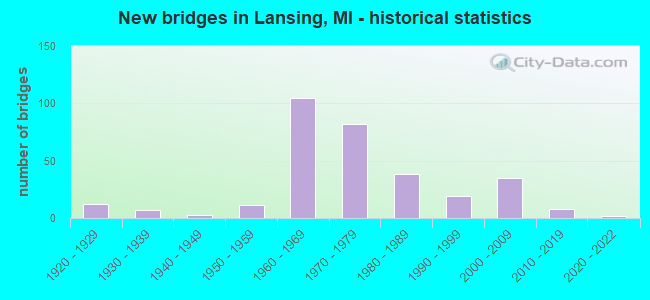
- New bridges - historical statistics
- 121920-1929
- 71930-1939
- 31940-1949
- 111950-1959
- 1051960-1969
- 821970-1979
- 381980-1989
- 191990-1999
- 352000-2009
- 82010-2019
- 22020-2022
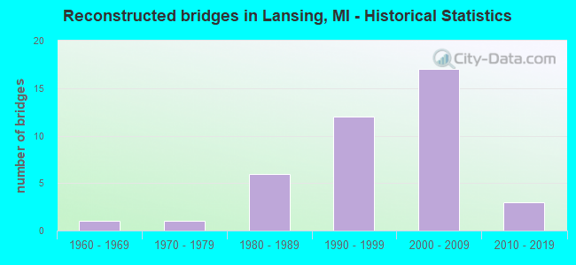
- Reconstructed bridges - Historical Statistics
- 11960-1969
- 11970-1979
- 61980-1989
- 121990-1999
- 172000-2009
- 32010-2019
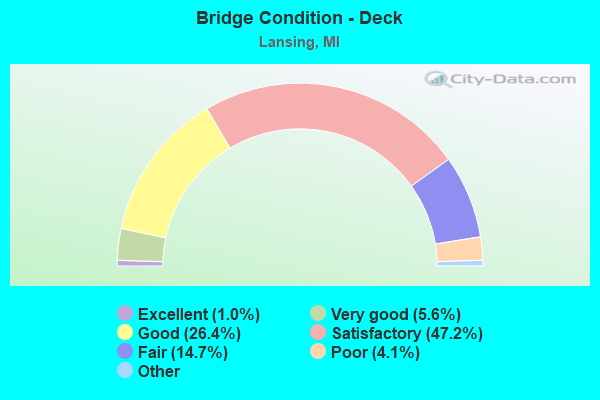
- Bridge Condition - Deck
- 1.0%Excellent
- 5.6%Very good
- 26.4%Good
- 47.2%Satisfactory
- 14.7%Fair
- 4.1%Poor
- 1.0%Serious
- 0.5%Critical
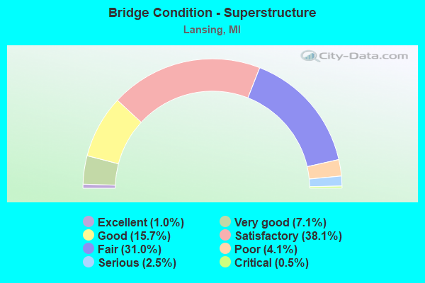
- Bridge Condition - Superstructure
- 1.0%Excellent
- 7.1%Very good
- 15.7%Good
- 38.1%Satisfactory
- 31.0%Fair
- 4.1%Poor
- 2.5%Serious
- 0.5%Critical
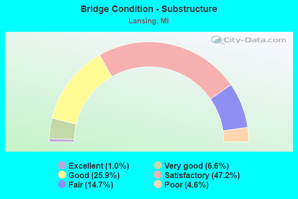
- Bridge Condition - Substructure
- 1.0%Excellent
- 6.6%Very good
- 25.9%Good
- 47.2%Satisfactory
- 14.7%Fair
- 4.6%Poor
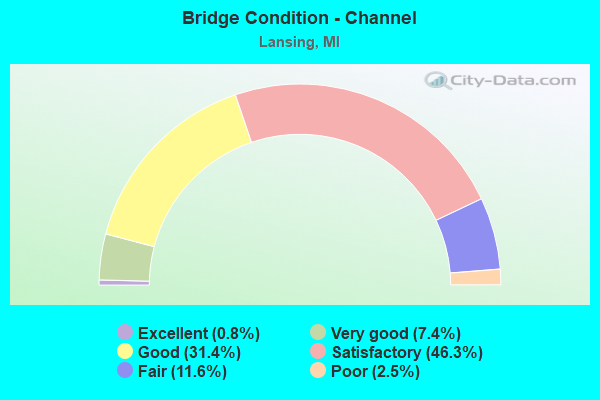
- Bridge Condition - Channel
- 0.8%Excellent
- 7.4%Very good
- 31.4%Good
- 46.3%Satisfactory
- 11.6%Fair
- 2.5%Poor
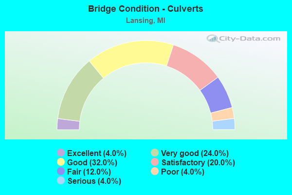
- Bridge Condition - Culverts
- 4.0%Excellent
- 24.0%Very good
- 32.0%Good
- 20.0%Satisfactory
- 12.0%Fair
- 4.0%Poor
- 4.0%Serious
Find on map >> Show street view
Structure Number: 187, Location: APPROX 0 40 MI W OF 18TH (Lat: 42.725142, Lng: -85.729739), Route carried "on" structure: County highway 382, Year Built: 1973, Status: Open, Structure Length: 0.76m (2.49ft), Average Daily Traffic: 8,204 (year 2003), Truck Traffic: 7%, Average Future Daily Traffic: 16,408 (year 2023), Design Load: HS 20+Mod, Features Intersected: RED RUN DRAIN, Facility Carried by Structure: 142ND AVE
Minimum Vertical Clearance: 30.48m (100.00ft), Kilometerpoint: 21.959, Lanes on structure: 2, Owner: County Highway Agency, Approaching Roadway Width: 10.4m (34.1ft), Skew: 4 degrees, Material/Design: Steel, Design/Construction: Culvert, Number Of Spans In Main Unit: 2, Length of Maximum Span: 3.0m (9.8ft)
Condition: Channel: Satisfactory, Culverts: Poor, Operating Rating: 71.9 metric tons, Method Used To Determine Operating Rating: Load Factor (LF) rating reported by rating factor (RF) method using MS18 loading, Inventory Rating: 43.1 metric tons, Method Used To Determine Inventory Rating: Load Factor (LF) rating reported by rating factor (RF) method using MS18 loading, Structural Evaluation: Meets minimum limits, Waterway Adequacy: Equal to present minimum criteria, Approach Roadway Alignment: Equal to present desirable criteria, Designated Inspection Frequency: Every 12 months, Inspection Date: October 2021
Find on map >> Show street view
Structure Number: 188, Location: APPROX 0.25 MI W OF 52ND (Lat: 42.754783, Lng: -86.060994), Route carried "on" structure: County highway 386, Year Built: 1979, Status: Open, Structure Length: 1.09m (3.58ft), Average Daily Traffic: 4,413 (year 2019), Truck Traffic: 4%, Average Future Daily Traffic: 5,400 (year 2039), Design Load: HS 20+Mod, Features Intersected: N BR MACATAWA RIVER, Facility Carried by Structure: 146TH AVE
Minimum Vertical Clearance: 30.48m (100.00ft), Kilometerpoint: 3.565, Lanes on structure: 2, Owner: County Highway Agency, Approaching Roadway Width: 9.1m (29.9ft), Material/Design: Prestressed concrete, Design/Construction: Box Beam or Girders - Multiple, Number Of Spans In Main Unit: 1, Length of Maximum Span: 10.9m (35.8ft), Curb-To-Curb Width: 10.1m (33.1ft), Out-to-Out Width: 10.2m (33.5ft)
Condition: Deck: Satisfactory, Superstructure: Satisfactory, Substructure: Good, Channel: Satisfactory, Operating Rating: 50.9 metric tons, Method Used To Determine Operating Rating: Field evaluation and documented engineering judgment, Inventory Rating: 30.4 metric tons, Method Used To Determine Inventory Rating: Field evaluation and documented engineering judgment, Structural Evaluation: Equal to present minimum criteria, Deck Geometry: Meets minimum limits, Waterway Adequacy: Equal to present desirable criteria, Approach Roadway Alignment: Equal to present desirable criteria, Designated Inspection Frequency: Every 24 months, Inspection Date: October 2021, Deck Structure Type: Concrete Precast Panels, Wearing Surface/Protective System: Wearing Surface: Bituminous, Membrane: Other
Find on map >> Show street view
Structure Number: 192, Location: JUST SOUTH OF 106TH AVE (Lat: 42.461933, Lng: -86.129114), Route carried "on" structure: County highway , Year Built: 1969, Status: Open, Structure Length: 1.84m (6.04ft), Average Daily Traffic: 320 (year 2003), Truck Traffic: 7%, Average Future Daily Traffic: 640 (year 2023), Design Load: HS 20+Mod, Features Intersected: M BR BLACK RIVER, Facility Carried by Structure: 60TH STREET
Minimum Vertical Clearance: 30.48m (100.00ft), Kilometerpoint: 4.762, Lanes on structure: 2, Owner: County Highway Agency, Approaching Roadway Width: 10.1m (33.1ft), Skew: 3 degrees, Material/Design: Prestressed concrete, Design/Construction: Box Beam or Girders - Multiple, Number Of Spans In Main Unit: 1, Length of Maximum Span: 18.4m (60.4ft), Curb-To-Curb Width: 10.1m (33.1ft), Out-to-Out Width: 10.2m (33.5ft)
Condition: Deck: Good, Superstructure: Good, Substructure: Good, Channel: Satisfactory, Operating Rating: 64.2 metric tons, Method Used To Determine Operating Rating: Load Factor (LF) rating reported by rating factor (RF) method using MS18 loading, Inventory Rating: 38.6 metric tons, Method Used To Determine Inventory Rating: Load Factor (LF) rating reported by rating factor (RF) method using MS18 loading, Structural Evaluation: Better than present minimum criteria, Deck Geometry: Better than present minimum criteria, Waterway Adequacy: Equal to present desirable criteria, Approach Roadway Alignment: Better than present minimum criteria, Designated Inspection Frequency: Every 24 months, Inspection Date: September 2021, Deck Structure Type: Concrete Precast Panels, Wearing Surface/Protective System: Wearing Surface: Bituminous, Membrane: Other
Find on map >> Show street view
Structure Number: 258, Location: HOPKINS TWP SEC 5-6 (Lat: 42.677833, Lng: -85.761053), Route carried "on" structure: County highway , Year Built: 1980, Status: Posted for load, Structure Length: 3.14m (10.30ft), Average Daily Traffic: 396 (year 2017), Truck Traffic: 7%, Average Future Daily Traffic: 588 (year 2037), Design Load: HS 20+Mod, Features Intersected: RABBIT RIVER, Facility Carried by Structure: 22ND STREET
Minimum Vertical Clearance: 30.48m (100.00ft), Kilometerpoint: 5.776, Lanes on structure: 2, Owner: County Highway Agency, Approaching Roadway Width: 9.1m (29.9ft), Material/Design: Prestressed concrete, Design/Construction: Box Beam or Girders - Multiple, Number Of Spans In Main Unit: 2, Length of Maximum Span: 15.5m (50.9ft), Curb-To-Curb Width: 8.7m (28.5ft), Out-to-Out Width: 9.3m (30.5ft)
Condition: Deck: Good, Superstructure: Satisfactory, Substructure: Satisfactory, Channel: Fair, Operating Rating: 44.7 metric tons, Method Used To Determine Operating Rating: Load Factor (LF) rating reported by rating factor (RF) method using MS18 loading, Inventory Rating: 26.9 metric tons, Method Used To Determine Inventory Rating: Load Factor (LF) rating reported by rating factor (RF) method using MS18 loading, Structural Evaluation: Equal to present minimum criteria, Deck Geometry: Equal to present minimum criteria, Waterway Adequacy: Equal to present desirable criteria, Approach Roadway Alignment: Equal to present desirable criteria, Bridge Posting: Required (Relationship of Operating Rating to Maximum Legal Load: 10.0 - 19.9% below), Designated Inspection Frequency: Every 24 months, Inspection Date: May 2021, Deck Structure Type: Concrete Precast Panels, Wearing Surface/Protective System: Wearing Surface: Bituminous, Membrane: Preformed Fabric
Find on map >> Show street view
Structure Number: 271, Location: LEIGHTON TWP SEC 30-31 (Lat: 42.695647, Lng: -85.655694), Route carried "on" structure: County highway , Year Built: 1983, Status: Open, Structure Length: 1.06m (3.48ft), Average Daily Traffic: 82 (year 2002), Truck Traffic: 7%, Average Future Daily Traffic: 164 (year 2022), Design Load: H 20, Features Intersected: RABBIT RIVER, Facility Carried by Structure: 138TH AVENUE
Minimum Vertical Clearance: 30.48m (100.00ft), Kilometerpoint: 0.304, Lanes on structure: 2, Owner: County Highway Agency, Approaching Roadway Width: 9.1m (29.9ft), Skew: 1 degrees, Material/Design: Steel, Design/Construction: Culvert, Number Of Spans In Main Unit: 2, Length of Maximum Span: 4.8m (15.7ft), Curb-To-Curb Width: 9.1m (29.9ft), Out-to-Out Width: 9.1m (29.9ft)
Condition: Channel: Satisfactory, Culverts: Satisfactory, Operating Rating: 21.4 metric tons, Method Used To Determine Operating Rating: Load Factor (LF) rating reported by rating factor (RF) method using MS18 loading, Inventory Rating: 13.0 metric tons, Method Used To Determine Inventory Rating: Load Factor (LF) rating reported by rating factor (RF) method using MS18 loading, Structural Evaluation: Meets minimum limits, Deck Geometry: Better than present minimum criteria, Waterway Adequacy: Equal to present minimum criteria, Approach Roadway Alignment: Equal to present desirable criteria, Designated Inspection Frequency: Every 24 months, Inspection Date: April 2021
Find on map >> Show street view
Structure Number: 281, Location: OTSEGO TWP SEC 5-6 (Lat: 42.498942, Lng: -85.760014), Route carried "on" structure: County highway , Year Built: 2003, Status: Open, Structure Length: 1.98m (6.50ft), Average Daily Traffic: 130 (year 2020), Truck Traffic: 7%, Average Future Daily Traffic: 193 (year 2040), Design Load: HS 20, Features Intersected: SCHNABLE BROOK, Facility Carried by Structure: 22ND STREET
Minimum Vertical Clearance: 30.48m (100.00ft), Kilometerpoint: 1.452, Lanes on structure: 2, Owner: County Highway Agency, Approaching Roadway Width: 9.4m (30.8ft), Skew: 1 degrees, Material/Design: Prestressed concrete, Design/Construction: Box Beam or Girders - Multiple, Number Of Spans In Main Unit: 1, Length of Maximum Span: 18.6m (61.0ft), Curb-To-Curb Width: 9.4m (30.8ft), Out-to-Out Width: 9.4m (30.8ft)
Condition: Deck: Satisfactory, Superstructure: Satisfactory, Substructure: Very good, Channel: Satisfactory, Operating Rating: 66.1 metric tons, Method Used To Determine Operating Rating: Load Factor (LF) rating reported by rating factor (RF) method using MS18 loading, Inventory Rating: 39.5 metric tons, Method Used To Determine Inventory Rating: Load Factor (LF) rating reported by rating factor (RF) method using MS18 loading, Structural Evaluation: Equal to present minimum criteria, Deck Geometry: Equal to present minimum criteria, Waterway Adequacy: Equal to present desirable criteria, Approach Roadway Alignment: Equal to present desirable criteria, Designated Inspection Frequency: Every 24 months, Inspection Date: April 2021, Deck Structure Type: Concrete Precast Panels, Wearing Surface/Protective System: Wearing Surface: Bituminous, Membrane: Preformed Fabric
Find on map >> Show street view
Structure Number: 369, Location: 800 FT EAST OF M-66 (Lat: 45.033222, Lng: -85.063897), Route carried "on" structure: County highway , Year Built: 1991, Status: Open, Structure Length: 1.09m (3.58ft), Average Daily Traffic: 10 (year 1997), Truck Traffic: 2%, Average Future Daily Traffic: 12 (year 2018), Design Load: HS 20, Features Intersected: JORDAN RIVER, Facility Carried by Structure: GRAVES CROSSING RD
Minimum Vertical Clearance: 30.48m (100.00ft), Kilometerpoint: 0.251, Lanes on structure: 2, Owner: County Highway Agency, Approaching Roadway Width: 9.1m (29.9ft), Material/Design: Wood or Timber, Design/Construction: Slab, Number Of Spans In Main Unit: 2, Length of Maximum Span: 5.1m (16.7ft), Curb-To-Curb Width: 7.3m (24.0ft), Out-to-Out Width: 8.2m (26.9ft)
Condition: Deck: Good, Superstructure: Good, Substructure: Good, Channel: Good, Operating Rating: 78.1 metric tons, Method Used To Determine Operating Rating: Allowable Stress (AS) rating reported by rating factor (RF) method using MS18 loading, Inventory Rating: 56.7 metric tons, Method Used To Determine Inventory Rating: Allowable Stress (AS) rating reported by rating factor (RF) method using MS18 loading, Structural Evaluation: Better than present minimum criteria, Deck Geometry: Equal to present minimum criteria, Waterway Adequacy: Equal to present desirable criteria, Approach Roadway Alignment: Equal to present desirable criteria, Designated Inspection Frequency: Every 24 months, Inspection Date: September 2020, Wearing Surface/Protective System: Wearing Surface: Bituminous
Find on map >> Show street view
Structure Number: 373, Location: 0.25MI E & 0.12MI N M-88 (Lat: 44.978347, Lng: -85.193131), Route carried "on" structure: City street 553, Year Built: 1988, Status: Open, Structure Length: 1.67m (5.48ft), Average Daily Traffic: 3,150 (year 1997), Truck Traffic: 5%, Average Future Daily Traffic: 7,500 (year 2019), Design Load: HS 20+Mod, Features Intersected: CEDAR RIVER, Facility Carried by Structure: DERENZY ROAD
Minimum Vertical Clearance: 30.48m (100.00ft), Kilometerpoint: 0.319, Lanes on structure: 2, Owner: City or Municipal Highway Agency, Approaching Roadway Width: 9.1m (29.9ft), Material/Design: Prestressed concrete, Design/Construction: Box Beam or Girders - Multiple, Number Of Spans In Main Unit: 1, Length of Maximum Span: 16.7m (54.8ft), Curb-To-Curb Width: 8.5m (27.9ft), Out-to-Out Width: 9.4m (30.8ft)
Condition: Deck: Good, Superstructure: Good, Substructure: Good, Channel: Good, Operating Rating: 54.1 metric tons, Method Used To Determine Operating Rating: Load Factor (LF) rating reported by rating factor (RF) method using MS18 loading, Inventory Rating: 32.4 metric tons, Method Used To Determine Inventory Rating: Load Factor (LF) rating reported by rating factor (RF) method using MS18 loading, Structural Evaluation: Better than present minimum criteria, Deck Geometry: Meets minimum limits, Waterway Adequacy: Equal to present minimum criteria, Approach Roadway Alignment: Superior to present desirable criteria, Designated Inspection Frequency: Every 24 months, Underwater Inspection Frequency: Every 60 months, Inspection Date: May 2020, Underwater Inspection Date: July 2021, Deck Structure Type: Concrete Precast Panels, Wearing Surface/Protective System: Wearing Surface: Bituminous, Membrane: Preformed Fabric, Deck Protection: Epoxy Coated Reinforcing
Find on map >> Show street view
Structure Number: 374, Location: IN CENTRAL LAKE (Lat: 45.070167, Lng: -85.258889), Route carried "on" structure: City street 624, Year Built: 1976, Status: Posted for load, Structure Length: 1.89m (6.20ft), Average Daily Traffic: 900 (year 0000), Truck Traffic: 7%, Average Future Daily Traffic: 900 (year 2008), Design Load: HS 20+Mod, Features Intersected: INTERMEDIATE RIVER, Facility Carried by Structure: STATE STREET
Minimum Vertical Clearance: 30.48m (100.00ft), Kilometerpoint: 5.192, Lanes on structure: 2, Owner: City or Municipal Highway Agency, Approaching Roadway Width: 11.8m (38.7ft), Material/Design: Prestressed concrete, Design/Construction: Box Beam or Girders - Multiple, Number Of Spans In Main Unit: 3, Length of Maximum Span: 6.7m (22.0ft), Curb or Sidewalk Widths: Left: 1.7m (5.6ft), Right: 1.7m (5.6ft), Curb-To-Curb Width: 7.9m (25.9ft), Out-to-Out Width: 12.1m (39.7ft)
Condition: Deck: Good, Superstructure: Good, Substructure: Fair, Channel: Satisfactory, Operating Rating: 18.8 metric tons, Method Used To Determine Operating Rating: Load and Resistance Factor Rating (LRFR) rating reported by rating factor(RF) method using HL-93 loadings, Inventory Rating: 14.6 metric tons, Method Used To Determine Inventory Rating: Load and Resistance Factor Rating (LRFR) rating reported by rating factor(RF) method using HL-93 loadings, Structural Evaluation: Meets minimum limits, Deck Geometry: Somewhat better than minimum adequacy, Waterway Adequacy: Superior to present desirable criteria, Approach Roadway Alignment: Superior to present desirable criteria, Bridge Posting: Required (Relationship of Operating Rating to Maximum Legal Load: 10.0 - 19.9% below), Designated Inspection Frequency: Every 12 months, Inspection Date: September 2021, Deck Structure Type: Concrete Precast Panels, Wearing Surface/Protective System: Wearing Surface: Bituminous, Membrane: Preformed Fabric
Find on map >> Show street view
Structure Number: 377, Location: 1.7 MI W OF STANDISH (Lat: 43.983017, Lng: -83.992439), Route carried "on" structure: State highway 61, Year Built: 1952, Status: Open, Structure Length: 0.73m (2.40ft), Average Daily Traffic: 4,242 (year 2007), Truck Traffic: 7%, Average Future Daily Traffic: 4,845 (year 2018), Design Load: HS 20, Features Intersected: M BR PINE RIVER
Minimum Vertical Clearance: 30.48m (100.00ft), Kilometerpoint: 4.249, Lanes on structure: 2, Base Highway Network: Yes (Inventory Route: 106, Subroute: 1), Owner: State Highway Agency, Approaching Roadway Width: 12.8m (42.0ft), Material/Design: Concrete, Design/Construction: Slab, Number Of Spans In Main Unit: 1, Length of Maximum Span: 7.3m (24.0ft), Curb or Sidewalk Widths: Left: 0.4m (1.3ft), Right: 0.4m (1.3ft), Curb-To-Curb Width: 11.5m (37.7ft), Out-to-Out Width: 13.2m (43.3ft)
Condition: Deck: Poor, Superstructure: Poor, Substructure: Satisfactory, Channel: Fair, Operating Rating: 46.0 metric tons, Method Used To Determine Operating Rating: Load Factor (LF) rating reported by rating factor (RF) method using MS18 loading, Inventory Rating: 27.5 metric tons, Method Used To Determine Inventory Rating: Load Factor (LF) rating reported by rating factor (RF) method using MS18 loading, Structural Evaluation: Meets minimum limits, Deck Geometry: Somewhat better than minimum adequacy, Waterway Adequacy: Better than present minimum criteria, Approach Roadway Alignment: Equal to present desirable criteria, Designated Inspection Frequency: Every 24 months, Inspection Date: May 2020, Deck Structure Type: Concrete Cast-file-Place, Wearing Surface/Protective System: Wearing Surface: Bituminous
Find on map >> Show street view
Structure Number: 379, Location: 1.0 MI N OF ALGER (Lat: 44.135747, Lng: -84.128286), Route carried "on" structure: State highway 33, Year Built: 1968, Status: Open, Structure Length: 9.60m (31.50ft), Average Daily Traffic: 4,124 (year 2007), Truck Traffic: 9%, Average Future Daily Traffic: 5,381 (year 2018), Design Load: HS 20, Features Intersected: D&M RR & OLD M-76
Minimum Vertical Clearance: 30.48m (100.00ft), Kilometerpoint: 1.154, Lanes on structure: 2, Lanes under structure: 2, Base Highway Network: Yes (Inventory Route: 106, Subroute: 8), Owner: State Highway Agency, Approaching Roadway Width: 15.8m (51.8ft), Skew: 3 degrees, Material/Design: Steel, Design/Construction: Stringer/Multi-beam, Number Of Spans In Main Unit: 5, Length of Maximum Span: 21.6m (70.9ft), Curb or Sidewalk Widths: Left: 0.2m (0.7ft), Right: 0.2m (0.7ft), Curb-To-Curb Width: 10.3m (33.8ft), Out-to-Out Width: 11.1m (36.4ft)
Condition: Deck: Poor, Superstructure: Fair, Substructure: Poor, Operating Rating: 81.0 metric tons, Method Used To Determine Operating Rating: Load Factor (LF) rating reported by rating factor (RF) method using MS18 loading, Inventory Rating: 48.6 metric tons, Method Used To Determine Inventory Rating: Load Factor (LF) rating reported by rating factor (RF) method using MS18 loading, Structural Evaluation: Meets minimum limits, Deck Geometry: Meets minimum limits, Underclear: Equal to present minimum criteria, Approach Roadway Alignment: Better than present minimum criteria, Designated Inspection Frequency: Every 12 months, Inspection Date: Febuary 2022, Deck Structure Type: Concrete Cast-file-Place, Wearing Surface/Protective System: Wearing Surface: Latex Concrete
Find on map >> Show street view
Structure Number: 381, Location: 0.3 MI E OF JCT I-75 (Lat: 43.949833, Lng: -84.006522), Route carried "on" structure: County highway , Year Built: 1968, Status: Open, Structure Length: 8.20m (26.90ft), Average Daily Traffic: 5,200 (year 1995), Truck Traffic: 9%, Average Future Daily Traffic: 5,980 (year 2015), Design Load: H 15, Features Intersected: US-23, Facility Carried by Structure: MELITA ROAD
Minimum Vertical Clearance: 4.34m (14.24ft), Kilometerpoint: 4.275, Lanes on structure: 2, Lanes under structure: 4, Owner: State Highway Agency, Approaching Roadway Width: 12.8m (42.0ft), Material/Design: Steel, Design/Construction: Stringer/Multi-beam, Number Of Spans In Main Unit: 5, Length of Maximum Span: 21.0m (68.9ft), Curb or Sidewalk Widths: Left: 0.2m (0.7ft), Right: 0.2m (0.7ft), Curb-To-Curb Width: 9.1m (29.9ft), Out-to-Out Width: 9.8m (32.2ft)
Condition: Deck: Good, Superstructure: Poor, Substructure: Good, Operating Rating: 55.7 metric tons, Method Used To Determine Operating Rating: Load Factor (LF) rating reported by rating factor (RF) method using MS18 loading, Inventory Rating: 33.4 metric tons, Method Used To Determine Inventory Rating: Load Factor (LF) rating reported by rating factor (RF) method using MS18 loading, Structural Evaluation: Meets minimum limits, Deck Geometry: Meets minimum limits, Underclear: Meets minimum limits, Approach Roadway Alignment: Somewhat better than minimum adequacy, Designated Inspection Frequency: Every 24 months, Inspection Date: November 2021, Deck Structure Type: Concrete Cast-file-Place, Wearing Surface/Protective System: Wearing Surface: Monolithic Concrete
Find on map >> Show street view
Structure Number: 727, Location: AT RIVER RD (Lat: 43.700428, Lng: -84.008225), Route carried "on" structure: County highway , Year Built: 1957, Status: Open, Structure Length: 1.46m (4.79ft), Average Daily Traffic: 279 (year 2000), Truck Traffic: 5%, Average Future Daily Traffic: 335 (year 2020), Design Load: H 20, Features Intersected: N BR KAWKAWLIN RIVER, Facility Carried by Structure: FRASER ROAD
Minimum Vertical Clearance: 30.48m (100.00ft), Kilometerpoint: 3.658, Lanes on structure: 2, Owner: County Highway Agency, Approaching Roadway Width: 7.3m (24.0ft), Material/Design: Prestressed concrete, Design/Construction: Box Beam or Girders - Multiple, Number Of Spans In Main Unit: 1, Length of Maximum Span: 14.0m (45.9ft), Curb-To-Curb Width: 8.5m (27.9ft), Out-to-Out Width: 8.8m (28.9ft)
Condition: Deck: Satisfactory, Superstructure: Satisfactory, Substructure: Satisfactory, Channel: Satisfactory, Operating Rating: 50.9 metric tons, Method Used To Determine Operating Rating: Field evaluation and documented engineering judgment, Inventory Rating: 30.7 metric tons, Method Used To Determine Inventory Rating: Field evaluation and documented engineering judgment, Structural Evaluation: Equal to present minimum criteria, Deck Geometry: Equal to present minimum criteria, Waterway Adequacy: Equal to present minimum criteria, Approach Roadway Alignment: Equal to present desirable criteria, Designated Inspection Frequency: Every 24 months, Inspection Date: May 2020, Deck Structure Type: Concrete Cast-file-Place, Wearing Surface/Protective System: Wearing Surface: Bituminous
Find on map >> Show street view
Structure Number: 969, Location: 2.5 MI SE OF BARODA (Lat: 41.927553, Lng: -86.470400), Route carried "on" structure: County highway , Year Built: 1924, Year Reconstructed: 1996, Status: Posted for load, Structure Length: 0.79m (2.59ft), Average Daily Traffic: 179 (year 2007), Truck Traffic: 8%, Average Future Daily Traffic: 200 (year 2027), Design Load: H 15, Features Intersected: HICKORY CREEK, Facility Carried by Structure: SNOW ROAD
Minimum Vertical Clearance: 30.48m (100.00ft), Kilometerpoint: 10.886, Lanes on structure: 2, Owner: County Highway Agency, Approaching Roadway Width: 6.7m (22.0ft), Material/Design: Wood or Timber, Design/Construction: Slab, Number Of Spans In Main Unit: 1, Length of Maximum Span: 6.7m (22.0ft), Curb-To-Curb Width: 6.9m (22.6ft), Out-to-Out Width: 7.3m (24.0ft)
Condition: Deck: Satisfactory, Superstructure: Good, Substructure: Poor, Channel: Satisfactory, Operating Rating: 52.5 metric tons, Method Used To Determine Operating Rating: Allowable Stress (AS) rating reported by rating factor (RF) method using MS18 loading, Inventory Rating: 37.3 metric tons, Method Used To Determine Inventory Rating: Allowable Stress (AS) rating reported by rating factor (RF) method using MS18 loading, Structural Evaluation: Meets minimum limits, Deck Geometry: Meets minimum limits, Waterway Adequacy: Equal to present desirable criteria, Approach Roadway Alignment: Equal to present minimum criteria, Bridge Posting: Required (Relationship of Operating Rating to Maximum Legal Load: > 39.9% below), Length Of Structure Improvement: 1.37m (4.49ft), Designated Inspection Frequency: Every 24 months, Inspection Date: June 2020, Bridge Improvement Cost: $210,000, Roadway Improvement Cost: $90,000, Total Project Cost: $300,000, Deck Structure Type: Wood or Timber, Wearing Surface/Protective System: Wearing Surface: Bituminous
Find on map >> Show street view
Structure Number: 988, Location: 1.0 MI N OF BARODA (Lat: 41.974539, Lng: -86.494667), Route carried "on" structure: County highway 1147, Year Built: 1964, Status: Open, Structure Length: 1.37m (4.49ft), Average Daily Traffic: 4,474 (year 2007), Truck Traffic: 4%, Average Future Daily Traffic: 6,500 (year 2027), Design Load: H 20, Features Intersected: HICKORY CREEK, Facility Carried by Structure: CLEVELAND AVE
Minimum Vertical Clearance: 30.48m (100.00ft), Kilometerpoint: 24.104, Lanes on structure: 2, Owner: County Highway Agency, Approaching Roadway Width: 12.2m (40.0ft), Skew: 4 degrees, Material/Design: Steel, Design/Construction: Stringer/Multi-beam, Number Of Spans In Main Unit: 1, Length of Maximum Span: 13.1m (43.0ft), Curb-To-Curb Width: 11.9m (39.0ft), Out-to-Out Width: 12.9m (42.3ft)
Condition: Deck: Good, Superstructure: Satisfactory, Substructure: Good, Channel: Satisfactory, Operating Rating: 69.7 metric tons, Method Used To Determine Operating Rating: Load Factor (LF) rating reported by rating factor (RF) method using MS18 loading, Inventory Rating: 41.8 metric tons, Method Used To Determine Inventory Rating: Load Factor (LF) rating reported by rating factor (RF) method using MS18 loading, Structural Evaluation: Equal to present minimum criteria, Deck Geometry: Somewhat better than minimum adequacy, Waterway Adequacy: Superior to present desirable criteria, Approach Roadway Alignment: Equal to present desirable criteria, Designated Inspection Frequency: Every 24 months, Inspection Date: June 2020, Deck Structure Type: Concrete Cast-file-Place, Wearing Surface/Protective System: Wearing Surface: Bituminous
Find on map >> Show street view
Structure Number: 1783, Location: AT EATON CO LINE (Lat: 42.771408, Lng: -84.605217), Route carried "on" structure: Business Interstate 96, Year Built: 1938, Status: Open, Structure Length: 5.94m (19.49ft), Average Daily Traffic: 10,600 (year 2009), Truck Traffic: 8%, Average Future Daily Traffic: 12,500 (year 2031), Design Load: HS 20, Features Intersected: CSX RR
Minimum Vertical Clearance: 30.48m (100.00ft), Kilometerpoint: 19.850, Lanes on structure: 4, Base Highway Network: Yes (Inventory Route: 20, Subroute: 6), Owner: State Highway Agency, Approaching Roadway Width: 15.2m (49.9ft), Skew: 6 degrees, Material/Design: Steel, Design/Construction: Stringer/Multi-beam, Number Of Spans In Main Unit: 3, Length of Maximum Span: 22.3m (73.2ft), Curb-To-Curb Width: 15.2m (49.9ft), Out-to-Out Width: 16.2m (53.1ft)
Condition: Deck: Good, Superstructure: Satisfactory, Substructure: Fair, Operating Rating: 90.1 metric tons, Method Used To Determine Operating Rating: Load Factor (LF) rating reported by rating factor (RF) method using MS18 loading, Inventory Rating: 53.8 metric tons, Method Used To Determine Inventory Rating: Load Factor (LF) rating reported by rating factor (RF) method using MS18 loading, Structural Evaluation: Somewhat better than minimum adequacy, Deck Geometry: High priority of corrective action, Approach Roadway Alignment: Equal to present minimum criteria, Designated Inspection Frequency: Every 24 months, Inspection Date: April 2020, Deck Structure Type: Concrete Cast-file-Place, Wearing Surface/Protective System: Wearing Surface: Latex Concrete, Deck Protection: Epoxy Coated Reinforcing
Find on map >> Show street view
Structure Number: 1793, Location: AT I-96 BL (Lat: 42.785394, Lng: -84.672078), Route carried "on" structure: Interstate 96, Year Built: 1962, Year Reconstructed: 2009, Status: Open, Structure Length: 7.21m (23.65ft), Average Daily Traffic: 18,210 (year 2007), Truck Traffic: 18%, Average Future Daily Traffic: 16,114 (year 2018), Design Load: HS 20+Mod, Features Intersected: I-96 BL
Minimum Vertical Clearance: 30.48m (100.00ft), Kilometerpoint: 14.594, Lanes on structure: 2, Lanes under structure: 4, Base Highway Network: Yes (Inventory Route: 20, Subroute: 1), Owner: State Highway Agency, Approaching Roadway Width: 17.6m (57.7ft), Skew: 13 degrees, Material/Design: Steel, Design/Construction: Stringer/Multi-beam, Number Of Spans In Main Unit: 4, Length of Maximum Span: 21.2m (69.6ft), Curb-To-Curb Width: 13.3m (43.6ft), Out-to-Out Width: 14.5m (47.6ft)
Condition: Deck: Satisfactory, Superstructure: Fair, Substructure: Satisfactory, Operating Rating: 69.7 metric tons, Method Used To Determine Operating Rating: Load Factor (LF) rating reported by rating factor (RF) method using MS18 loading, Inventory Rating: 41.8 metric tons, Method Used To Determine Inventory Rating: Load Factor (LF) rating reported by rating factor (RF) method using MS18 loading, Structural Evaluation: Somewhat better than minimum adequacy, Deck Geometry: Superior to present desirable criteria, Underclear: Equal to present minimum criteria, Approach Roadway Alignment: Equal to present desirable criteria, Designated Inspection Frequency: Every 24 months, Inspection Date: April 2020, Deck Structure Type: Concrete Cast-file-Place, Wearing Surface/Protective System: Wearing Surface: Latex Concrete
Find on map >> Show street view
Structure Number: 1865, Location: 1 MI E OF US-27 (Lat: 42.816539, Lng: -84.523136), Route carried "on" structure: Interstate 69, Year Built: 1971, Status: Open, Structure Length: 3.07m (10.07ft), Average Daily Traffic: 18,989 (year 2007), Truck Traffic: 16%, Average Future Daily Traffic: 24,602 (year 2018), Design Load: HS 20, Features Intersected: WOOD RD
Minimum Vertical Clearance: 30.48m (100.00ft), Kilometerpoint: 13.971, Lanes on structure: 3, Lanes under structure: 2, Base Highway Network: Yes (Inventory Route: 36, Subroute: 5), Owner: State Highway Agency, Approaching Roadway Width: 18.6m (61.0ft), Skew: 2 degrees, Material/Design: Steel, Design/Construction: Stringer/Multi-beam, Number Of Spans In Main Unit: 1, Length of Maximum Span: 30.7m (100.7ft), Curb-To-Curb Width: 17.9m (58.7ft), Out-to-Out Width: 18.5m (60.7ft)
Condition: Deck: Fair, Superstructure: Fair, Substructure: Satisfactory, Operating Rating: 68.0 metric tons, Method Used To Determine Operating Rating: Load Factor (LF) rating reported by rating factor (RF) method using MS18 loading, Inventory Rating: 40.5 metric tons, Method Used To Determine Inventory Rating: Load Factor (LF) rating reported by rating factor (RF) method using MS18 loading, Structural Evaluation: Somewhat better than minimum adequacy, Deck Geometry: Better than present minimum criteria, Underclear: Meets minimum limits, Approach Roadway Alignment: Equal to present desirable criteria, Designated Inspection Frequency: Every 24 months, Inspection Date: April 2020, Deck Structure Type: Concrete Cast-file-Place, Wearing Surface/Protective System: Wearing Surface: Monolithic Concrete
Find on map >> Show street view
Structure Number: 1866, Location: 1 MI E OF US-27 (Lat: 42.816981, Lng: -84.523136), Route carried "on" structure: Interstate 69, Year Built: 1971, Status: Open, Structure Length: 3.04m (9.97ft), Average Daily Traffic: 18,989 (year 2007), Truck Traffic: 16%, Average Future Daily Traffic: 24,602 (year 2018), Design Load: HS 20, Features Intersected: WOOD RD
Minimum Vertical Clearance: 30.48m (100.00ft), Kilometerpoint: 14.628, Lanes on structure: 3, Lanes under structure: 2, Base Highway Network: Yes (Inventory Route: 36, Subroute: 2), Owner: State Highway Agency, Approaching Roadway Width: 18.6m (61.0ft), Skew: 2 degrees, Material/Design: Steel, Design/Construction: Stringer/Multi-beam, Number Of Spans In Main Unit: 1, Length of Maximum Span: 30.4m (99.7ft), Curb-To-Curb Width: 17.5m (57.4ft), Out-to-Out Width: 18.0m (59.1ft)
Condition: Deck: Fair, Superstructure: Fair, Substructure: Good, Operating Rating: 67.4 metric tons, Method Used To Determine Operating Rating: Load Factor (LF) rating reported by rating factor (RF) method using MS18 loading, Inventory Rating: 40.2 metric tons, Method Used To Determine Inventory Rating: Load Factor (LF) rating reported by rating factor (RF) method using MS18 loading, Structural Evaluation: Somewhat better than minimum adequacy, Deck Geometry: Better than present minimum criteria, Underclear: Meets minimum limits, Approach Roadway Alignment: Equal to present desirable criteria, Designated Inspection Frequency: Every 24 months, Inspection Date: April 2020, Deck Structure Type: Concrete Cast-file-Place, Wearing Surface/Protective System: Wearing Surface: Monolithic Concrete
Find on map >> Show street view
Structure Number: 1867, Location: AT N LTS OF LANSING (Lat: 42.817750, Lng: -84.542783), Route carried "on" structure: Business US 127, Year Built: 1971, Year Reconstructed: 2009, Status: Open, Structure Length: 7.70m (25.26ft), Average Daily Traffic: 22,550 (year 2010), Truck Traffic: 1%, Average Future Daily Traffic: 24,360 (year 2030), Design Load: HS 20, Features Intersected: I-69
Minimum Vertical Clearance: 30.48m (100.00ft), Kilometerpoint: 5.301, Lanes on structure: 6, Lanes under structure: 6, Base Highway Network: Yes (Inventory Route: 20, Subroute: 3), Owner: State Highway Agency, Approaching Roadway Width: 37.8m (124.0ft), Skew: 20 degrees, Material/Design: Steel, Design/Construction: Stringer/Multi-beam, Number Of Spans In Main Unit: 2, Length of Maximum Span: 38.8m (127.3ft), Curb-To-Curb Width: 36.0m (118.1ft), Out-to-Out Width: 36.9m (121.1ft)
Condition: Deck: Satisfactory, Superstructure: Satisfactory, Substructure: Fair, Operating Rating: 67.7 metric tons, Method Used To Determine Operating Rating: Load Factor (LF) rating reported by rating factor (RF) method using MS18 loading, Inventory Rating: 40.5 metric tons, Method Used To Determine Inventory Rating: Load Factor (LF) rating reported by rating factor (RF) method using MS18 loading, Structural Evaluation: Somewhat better than minimum adequacy, Deck Geometry: Superior to present desirable criteria, Underclear: Somewhat better than minimum adequacy, Approach Roadway Alignment: Equal to present desirable criteria, Designated Inspection Frequency: Every 24 months, Inspection Date: April 2020, Deck Structure Type: Concrete Cast-file-Place, Wearing Surface/Protective System: Wearing Surface: Epoxy Overlay, Deck Protection: Epoxy Coated Reinforcing
Find on map >> Show street view
Structure Number: 1868, Location: 1.2 MI S OF DEWITT (Lat: 42.816886, Lng: -84.560556), Route carried "on" structure: Interstate 69, Year Built: 1980, Status: Open, Structure Length: 3.44m (11.29ft), Average Daily Traffic: 18,999 (year 2007), Truck Traffic: 17%, Average Future Daily Traffic: 25,598 (year 2018), Design Load: HS 25 or greater, Features Intersected: TURNER RD
Minimum Vertical Clearance: 30.48m (100.00ft), Kilometerpoint: 11.531, Lanes on structure: 2, Lanes under structure: 2, Base Highway Network: Yes (Inventory Route: 36, Subroute: 2), Owner: State Highway Agency, Approaching Roadway Width: 12.8m (42.0ft), Skew: 3 degrees, Material/Design: Steel, Design/Construction: Stringer/Multi-beam, Number Of Spans In Main Unit: 1, Length of Maximum Span: 34.4m (112.9ft), Curb-To-Curb Width: 12.5m (41.0ft), Out-to-Out Width: 13.8m (45.3ft)
Condition: Deck: Fair, Superstructure: Satisfactory, Substructure: Satisfactory, Operating Rating: 88.1 metric tons, Method Used To Determine Operating Rating: Load Factor (LF) rating reported by rating factor (RF) method using MS18 loading, Inventory Rating: 52.8 metric tons, Method Used To Determine Inventory Rating: Load Factor (LF) rating reported by rating factor (RF) method using MS18 loading, Structural Evaluation: Equal to present minimum criteria, Deck Geometry: Better than present minimum criteria, Underclear: Meets minimum limits, Approach Roadway Alignment: Equal to present desirable criteria, Designated Inspection Frequency: Every 24 months, Inspection Date: April 2020, Deck Structure Type: Concrete Cast-file-Place, Wearing Surface/Protective System: Wearing Surface: Epoxy Overlay, Membrane: Epoxy, Deck Protection: Epoxy Coated Reinforcing
Find on map >> Show street view
Structure Number: 1869, Location: 0.6 MI SE OF DEWITT (Lat: 42.816203, Lng: -84.572372), Route carried "on" structure: County highway 2003, Year Built: 1980, Status: Open, Structure Length: 7.98m (26.18ft), Average Daily Traffic: 70 (year 1984), Truck Traffic: 3%, Average Future Daily Traffic: 11,000 (year 2015), Design Load: HS 25 or greater, Features Intersected: I-69, Facility Carried by Structure: DEWITT RD
Minimum Vertical Clearance: 30.48m (100.00ft), Kilometerpoint: 1.936, Lanes on structure: 5, Lanes under structure: 5, Owner: State Highway Agency, Approaching Roadway Width: 28.6m (93.8ft), Material/Design: Steel continuous, Design/Construction: Stringer/Multi-beam, Number Of Spans In Main Unit: 2, Length of Maximum Span: 39.3m (128.9ft), Curb-To-Curb Width: 27.6m (90.6ft), Out-to-Out Width: 28.8m (94.5ft)
Condition: Deck: Satisfactory, Superstructure: Satisfactory, Substructure: Satisfactory, Operating Rating: 97.2 metric tons, Method Used To Determine Operating Rating: Load Factor (LF) rating reported by rating factor (RF) method using MS18 loading, Inventory Rating: 66.1 metric tons, Method Used To Determine Inventory Rating: Load Factor (LF) rating reported by rating factor (RF) method using MS18 loading, Structural Evaluation: Equal to present minimum criteria, Deck Geometry: Superior to present desirable criteria, Underclear: Somewhat better than minimum adequacy, Approach Roadway Alignment: Equal to present desirable criteria, Designated Inspection Frequency: Every 24 months, Inspection Date: April 2020, Deck Structure Type: Concrete Cast-file-Place, Wearing Surface/Protective System: Wearing Surface: Epoxy Overlay, Membrane: Epoxy, Deck Protection: Epoxy Coated Reinforcing
Find on map >> Show street view
Structure Number: 1871, Location: 4.0 MI NW OF LANSING (Lat: 42.807772, Lng: -84.602728), Route carried "on" structure: County highway 1949, Year Built: 1981, Status: Open, Structure Length: 8.20m (26.90ft), Average Daily Traffic: 4,494 (year 1984), Truck Traffic: 5%, Average Future Daily Traffic: 12,500 (year 2015), Design Load: HS 20, Features Intersected: I-69, Facility Carried by Structure: AIRPORT ROAD
Minimum Vertical Clearance: 30.48m (100.00ft), Kilometerpoint: 4.094, Lanes on structure: 2, Lanes under structure: 4, Owner: State Highway Agency, Approaching Roadway Width: 13.0m (42.7ft), Material/Design: Steel, Design/Construction: Stringer/Multi-beam, Number Of Spans In Main Unit: 2, Length of Maximum Span: 41.7m (136.8ft), Curb-To-Curb Width: 13.2m (43.3ft), Out-to-Out Width: 13.9m (45.6ft)
Condition: Deck: Satisfactory, Superstructure: Satisfactory, Substructure: Good, Operating Rating: 81.6 metric tons, Method Used To Determine Operating Rating: Load Factor (LF) rating reported by rating factor (RF) method using MS18 loading, Inventory Rating: 48.9 metric tons, Method Used To Determine Inventory Rating: Load Factor (LF) rating reported by rating factor (RF) method using MS18 loading, Structural Evaluation: Equal to present minimum criteria, Deck Geometry: Equal to present minimum criteria, Underclear: Equal to present minimum criteria, Approach Roadway Alignment: Equal to present desirable criteria, Designated Inspection Frequency: Every 24 months, Inspection Date: April 2020, Deck Structure Type: Concrete Cast-file-Place, Wearing Surface/Protective System: Wearing Surface: Epoxy Overlay, Membrane: Epoxy, Deck Protection: Epoxy Coated Reinforcing
Find on map >> Show street view
Structure Number: 1872, Location: 5.5 MI NW OF LANSING (Lat: 42.798267, Lng: -84.641953), Route carried "on" structure: County highway , Year Built: 1981, Status: Open, Structure Length: 11.15m (36.58ft), Average Daily Traffic: 210 (year 1984), Truck Traffic: 3%, Average Future Daily Traffic: 400 (year 2015), Design Load: HS 20, Features Intersected: I-69, Facility Carried by Structure: LOWELL RD
Minimum Vertical Clearance: 30.48m (100.00ft), Kilometerpoint: 2.078, Lanes on structure: 2, Lanes under structure: 4, Owner: State Highway Agency, Approaching Roadway Width: 10.3m (33.8ft), Skew: 3 degrees, Material/Design: Steel, Design/Construction: Stringer/Multi-beam, Number Of Spans In Main Unit: 4, Length of Maximum Span: 40.2m (131.9ft), Curb-To-Curb Width: 10.9m (35.8ft), Out-to-Out Width: 12.1m (39.7ft)
Condition: Deck: Satisfactory, Superstructure: Fair, Substructure: Good, Operating Rating: 87.5 metric tons, Method Used To Determine Operating Rating: Load Factor (LF) rating reported by rating factor (RF) method using MS18 loading, Inventory Rating: 52.5 metric tons, Method Used To Determine Inventory Rating: Load Factor (LF) rating reported by rating factor (RF) method using MS18 loading, Structural Evaluation: Somewhat better than minimum adequacy, Deck Geometry: Better than present minimum criteria, Underclear: Somewhat better than minimum adequacy, Approach Roadway Alignment: Equal to present desirable criteria, Designated Inspection Frequency: Every 24 months, Inspection Date: April 2020, Deck Structure Type: Concrete Cast-file-Place, Wearing Surface/Protective System: Wearing Surface: Monolithic Concrete, Deck Protection: Epoxy Coated Reinforcing
Find on map >> Show street view
Structure Number: 1873, Location: 6.0 M NW OF LANSING (Lat: 42.787653, Lng: -84.660778), Route carried "on" structure: Interstate 69, Year Built: 1981, Status: Open, Structure Length: 8.78m (28.81ft), Average Daily Traffic: 10,507 (year 2007), Truck Traffic: 16%, Average Future Daily Traffic: 23,290 (year 2018), Design Load: HS 25 or greater, Features Intersected: EB TURNING ROADWAY
Minimum Vertical Clearance: 30.48m (100.00ft), Kilometerpoint: 2.305, Lanes on structure: 2, Lanes under structure: 2, Base Highway Network: Yes (Inventory Route: 36, Subroute: 2), Owner: State Highway Agency, Approaching Roadway Width: 12.8m (42.0ft), Skew: 5 degrees, Material/Design: Steel, Design/Construction: Stringer/Multi-beam, Number Of Spans In Main Unit: 3, Length of Maximum Span: 49.0m (160.8ft), Curb-To-Curb Width: 13.2m (43.3ft), Out-to-Out Width: 13.9m (45.6ft)
Condition: Deck: Fair, Superstructure: Fair, Substructure: Satisfactory, Operating Rating: 97.2 metric tons, Method Used To Determine Operating Rating: Load Factor (LF) rating reported by rating factor (RF) method using MS18 loading, Inventory Rating: 63.2 metric tons, Method Used To Determine Inventory Rating: Load Factor (LF) rating reported by rating factor (RF) method using MS18 loading, Structural Evaluation: Somewhat better than minimum adequacy, Deck Geometry: Superior to present desirable criteria, Underclear: Equal to present minimum criteria, Approach Roadway Alignment: Equal to present desirable criteria, Designated Inspection Frequency: Every 24 months, Inspection Date: April 2020, Deck Structure Type: Concrete Cast-file-Place, Wearing Surface/Protective System: Wearing Surface: Latex Concrete, Deck Protection: Epoxy Coated Reinforcing
Find on map >> Show street view
Structure Number: 1874, Location: 6.0 MI NW OF LANSING (Lat: 42.787792, Lng: -84.659944), Route carried "on" structure: Interstate 69, Year Built: 1981, Status: Open, Structure Length: 10.33m (33.89ft), Average Daily Traffic: 10,507 (year 2007), Truck Traffic: 16%, Average Future Daily Traffic: 23,290 (year 2018), Design Load: HS 25 or greater, Features Intersected: EB TURNING ROADWAY
Minimum Vertical Clearance: 30.48m (100.00ft), Kilometerpoint: 1.733, Lanes on structure: 2, Lanes under structure: 2, Base Highway Network: Yes (Inventory Route: 36, Subroute: 5), Owner: State Highway Agency, Approaching Roadway Width: 12.8m (42.0ft), Skew: 6 degrees, Material/Design: Steel, Design/Construction: Stringer/Multi-beam, Number Of Spans In Main Unit: 3, Length of Maximum Span: 57.9m (190.0ft), Curb-To-Curb Width: 13.2m (43.3ft), Out-to-Out Width: 13.9m (45.6ft)
Condition: Deck: Satisfactory, Superstructure: Fair, Substructure: Satisfactory, Operating Rating: 97.2 metric tons, Method Used To Determine Operating Rating: Load Factor (LF) rating reported by rating factor (RF) method using MS18 loading, Inventory Rating: 63.2 metric tons, Method Used To Determine Inventory Rating: Load Factor (LF) rating reported by rating factor (RF) method using MS18 loading, Structural Evaluation: Somewhat better than minimum adequacy, Deck Geometry: Superior to present desirable criteria, Underclear: Equal to present minimum criteria, Approach Roadway Alignment: Equal to present desirable criteria, Designated Inspection Frequency: Every 24 months, Inspection Date: April 2020, Deck Structure Type: Concrete Cast-file-Place, Wearing Surface/Protective System: Wearing Surface: Epoxy Overlay, Membrane: Epoxy, Deck Protection: Epoxy Coated Reinforcing
Find on map >> Show street view
Structure Number: 1879, Location: 7 MI NW OF LANSING (Lat: 42.789400, Lng: -84.675869), Route carried "on" structure: Ramp Interstate 69, Year Built: 1981, Status: Open, Structure Length: 17.75m (58.23ft), Average Daily Traffic: 4,012 (year 2007), Truck Traffic: 11%, Average Future Daily Traffic: 9,811 (year 2018), Design Load: HS 25 or greater, Features Intersected: I-96, Facility Carried by Structure: EB TURNING RDWY
Minimum Vertical Clearance: 30.48m (100.00ft), Kilometerpoint: 1.495, Lanes on structure: 2, Lanes under structure: 7, Owner: State Highway Agency, Approaching Roadway Width: 13.9m (45.6ft), Skew: 6 degrees, Material/Design: Steel continuous, Design/Construction: Stringer/Multi-beam, Number Of Spans In Main Unit: 4, Length of Maximum Span: 66.3m (217.5ft), Curb-To-Curb Width: 12.8m (42.0ft), Out-to-Out Width: 14.0m (45.9ft)
Condition: Deck: Satisfactory, Superstructure: Satisfactory, Substructure: Satisfactory, Operating Rating: 77.4 metric tons, Method Used To Determine Operating Rating: Load Factor (LF) rating reported by rating factor (RF) method using MS18 loading, Inventory Rating: 46.3 metric tons, Method Used To Determine Inventory Rating: Load Factor (LF) rating reported by rating factor (RF) method using MS18 loading, Structural Evaluation: Equal to present minimum criteria, Deck Geometry: Superior to present desirable criteria, Underclear: Equal to present minimum criteria, Approach Roadway Alignment: Equal to present desirable criteria, Designated Inspection Frequency: Every 24 months, Inspection Date: April 2020, Deck Structure Type: Concrete Cast-file-Place, Wearing Surface/Protective System: Wearing Surface: Latex Concrete, Deck Protection: Epoxy Coated Reinforcing
Find on map >> Show street view
Structure Number: 1881, Location: 3.5 MI W OF FOWLER (Lat: 43.001975, Lng: -84.810372), Route carried "on" structure: State highway 21, Year Built: 2005, Status: Open, Structure Length: 0.66m (2.17ft), Average Daily Traffic: 2,731 (year 2007), Truck Traffic: 11%, Average Future Daily Traffic: 3,957 (year 2018), Design Load: HS 25 or greater, Features Intersected: LOST CREEK
Minimum Vertical Clearance: 30.48m (100.00ft), Kilometerpoint: 2.206, Lanes on structure: 2, Base Highway Network: Yes (Inventory Route: 20, Subroute: 9), Owner: State Highway Agency, Approaching Roadway Width: 12.2m (40.0ft), Material/Design: Concrete, Design/Construction: Culvert, Number Of Spans In Main Unit: 1, Length of Maximum Span: 6.1m (20.0ft)
Condition: Channel: Satisfactory, Culverts: Good, Operating Rating: 67.1 metric tons, Method Used To Determine Operating Rating: Load Factor (LF) rating reported by rating factor (RF) method using MS18 loading, Inventory Rating: 40.2 metric tons, Method Used To Determine Inventory Rating: Load Factor (LF) rating reported by rating factor (RF) method using MS18 loading, Structural Evaluation: Better than present minimum criteria, Waterway Adequacy: Equal to present desirable criteria, Approach Roadway Alignment: Equal to present desirable criteria, Length Of Structure Improvement: 0.70m (2.30ft), Designated Inspection Frequency: Every 24 months, Inspection Date: October 2020, Bridge Improvement Cost: $8,000, Roadway Improvement Cost: $1,000, Total Project Cost: $9,000, Deck Structure Type: Concrete Cast-file-Place, Wearing Surface/Protective System: Wearing Surface: Bituminous
Find on map >> Show street view
Structure Number: 1882, Location: 3.2 MI E OF FOWLER (Lat: 43.001700, Lng: -84.675056), Route carried "on" structure: State highway 21, Year Built: 1977, Status: Open, Structure Length: 0.97m (3.18ft), Average Daily Traffic: 4,192 (year 2007), Truck Traffic: 8%, Average Future Daily Traffic: 5,120 (year 2018), Design Load: HS 25 or greater, Features Intersected: NORTH SWARGART DRAIN
Minimum Vertical Clearance: 30.48m (100.00ft), Kilometerpoint: 12.510, Lanes on structure: 2, Base Highway Network: Yes (Inventory Route: 20, Subroute: 9), Owner: State Highway Agency, Approaching Roadway Width: 17.1m (56.1ft), Skew: 4 degrees, Material/Design: Prestressed concrete, Design/Construction: Box Beam or Girders - Multiple, Number Of Spans In Main Unit: 1, Length of Maximum Span: 9.7m (31.8ft), Curb-To-Curb Width: 14.9m (48.9ft), Out-to-Out Width: 15.7m (51.5ft)
Condition: Deck: Fair, Superstructure: Satisfactory, Substructure: Satisfactory, Channel: Good, Operating Rating: 73.2 metric tons, Method Used To Determine Operating Rating: Load Factor (LF) rating reported by rating factor (RF) method using MS18 loading, Inventory Rating: 44.4 metric tons, Method Used To Determine Inventory Rating: Load Factor (LF) rating reported by rating factor (RF) method using MS18 loading, Structural Evaluation: Equal to present minimum criteria, Deck Geometry: Superior to present desirable criteria, Waterway Adequacy: Equal to present desirable criteria, Approach Roadway Alignment: Equal to present desirable criteria, Designated Inspection Frequency: Every 24 months, Inspection Date: October 2020, Deck Structure Type: Concrete Cast-file-Place, Wearing Surface/Protective System: Wearing Surface: Integral Concrete
Find on map >> Show street view
Structure Number: 1918, Location: 1/2 MI N OF CLARK RD (Lat: 42.820747, Lng: -84.739519), Route carried "on" structure: County highway 1923, Year Built: 1996, Status: Open, Structure Length: 5.03m (16.50ft), Average Daily Traffic: 3,658 (year 2011), Truck Traffic: 5%, Average Future Daily Traffic: 6,607 (year 2031), Design Load: HS 20, Features Intersected: LOOKING GLASS RIVER, Facility Carried by Structure: WRIGHT ROAD
Minimum Vertical Clearance: 30.48m (100.00ft), Kilometerpoint: 5.635, Lanes on structure: 2, Owner: County Highway Agency, Approaching Roadway Width: 13.4m (44.0ft), Skew: 4 degrees, Material/Design: Prestressed concrete, Design/Construction: Box Beam or Girders - Multiple, Number Of Spans In Main Unit: 3, Length of Maximum Span: 16.7m (54.8ft), Curb-To-Curb Width: 12.5m (41.0ft), Out-to-Out Width: 13.3m (43.6ft)
Condition: Deck: Good, Superstructure: Good, Substructure: Very good, Channel: Good, Operating Rating: 78.8 metric tons, Method Used To Determine Operating Rating: Load Factor (LF), Inventory Rating: 47.3 metric tons, Method Used To Determine Inventory Rating: Load Factor (LF), Structural Evaluation: Better than present minimum criteria, Deck Geometry: Equal to present minimum criteria, Waterway Adequacy: Superior to present desirable criteria, Approach Roadway Alignment: Equal to present desirable criteria, Designated Inspection Frequency: Every 24 months, Inspection Date: October 2020, Deck Structure Type: Concrete Cast-file-Place, Wearing Surface/Protective System: Deck Protection: Epoxy Coated Reinforcing
Find on map >> Show street view
Structure Number: 1919, Location: 1/4 MI S OF PRICE RD (Lat: 42.925208, Lng: -84.739778), Route carried "on" structure: County highway 1923, Year Built: 2007, Status: Open, Structure Length: 0.61m (2.00ft), Average Daily Traffic: 1,026 (year 2011), Truck Traffic: 5%, Average Future Daily Traffic: 1,853 (year 2031), Design Load: HS 20, Features Intersected: MORRIS DRAIN, Facility Carried by Structure: WRIGHT ROAD
Minimum Vertical Clearance: 30.48m (100.00ft), Kilometerpoint: 17.362, Lanes on structure: 2, Owner: County Highway Agency, Approaching Roadway Width: 9.8m (32.2ft), Material/Design: Concrete, Design/Construction: Culvert, Number Of Spans In Main Unit: 1, Length of Maximum Span: 6.1m (20.0ft)
Condition: Channel: Satisfactory, Culverts: Very good, Operating Rating: 54.5 metric tons, Method Used To Determine Operating Rating: Field evaluation and documented engineering judgment, Inventory Rating: 32.7 metric tons, Method Used To Determine Inventory Rating: Field evaluation and documented engineering judgment, Structural Evaluation: Equal to present desirable criteria, Waterway Adequacy: Equal to present desirable criteria, Approach Roadway Alignment: Equal to present desirable criteria, Designated Inspection Frequency: Every 24 months, Inspection Date: October 2020, Wearing Surface/Protective System: Wearing Surface: Bituminous
Find on map >> Show street view
Structure Number: 1922, Location: 100' N OF STONE RD (Lat: 43.069153, Lng: -84.700275), Route carried "on" structure: County highway 1929, Year Built: 1991, Status: Open, Structure Length: 3.17m (10.40ft), Average Daily Traffic: 498 (year 2011), Truck Traffic: 2%, Average Future Daily Traffic: 899 (year 2031), Design Load: HS 20, Features Intersected: HAYWORTH DRAIN, Facility Carried by Structure: WACOUSTA ROAD
Minimum Vertical Clearance: 30.48m (100.00ft), Kilometerpoint: 4.128, Lanes on structure: 2, Owner: County Highway Agency, Approaching Roadway Width: 9.8m (32.2ft), Material/Design: Prestressed concrete, Design/Construction: Stringer/Multi-beam, Number Of Spans In Main Unit: 1, Length of Maximum Span: 30.4m (99.7ft), Curb-To-Curb Width: 10.4m (34.1ft), Out-to-Out Width: 11.5m (37.7ft)
Condition: Deck: Good, Superstructure: Very good, Substructure: Good, Channel: Very good, Operating Rating: 65.4 metric tons, Method Used To Determine Operating Rating: Load Factor (LF), Inventory Rating: 39.2 metric tons, Method Used To Determine Inventory Rating: Load Factor (LF), Structural Evaluation: Better than present minimum criteria, Deck Geometry: Equal to present minimum criteria, Waterway Adequacy: Superior to present desirable criteria, Approach Roadway Alignment: Meets minimum limits, Designated Inspection Frequency: Every 24 months, Inspection Date: October 2020, Deck Structure Type: Concrete Cast-file-Place, Wearing Surface/Protective System: Wearing Surface: Monolithic Concrete, Deck Protection: Epoxy Coated Reinforcing
Find on map >> Show street view
Structure Number: 1923, Location: 1/4 MI S OF ISLAND RD (Lat: 43.085614, Lng: -84.700022), Route carried "on" structure: County highway 1929, Year Built: 1991, Status: Open, Structure Length: 1.15m (3.77ft), Average Daily Traffic: 441 (year 2011), Truck Traffic: 2%, Average Future Daily Traffic: 796 (year 2031), Design Load: HS 20, Features Intersected: COX DRAIN (BROWN'S CR), Facility Carried by Structure: WACOUSTA ROAD
Minimum Vertical Clearance: 30.48m (100.00ft), Kilometerpoint: 5.955, Lanes on structure: 2, Owner: County Highway Agency, Approaching Roadway Width: 7.9m (25.9ft), Material/Design: Prestressed concrete, Design/Construction: Box Beam or Girders - Multiple, Number Of Spans In Main Unit: 1, Length of Maximum Span: 11.5m (37.7ft), Curb-To-Curb Width: 9.8m (32.2ft), Out-to-Out Width: 10.4m (34.1ft)
Condition: Deck: Good, Superstructure: Good, Substructure: Satisfactory, Channel: Good, Operating Rating: 99.0 metric tons, Method Used To Determine Operating Rating: Load Factor (LF), Inventory Rating: 73.8 metric tons, Method Used To Determine Inventory Rating: Load Factor (LF), Structural Evaluation: Equal to present minimum criteria, Deck Geometry: Equal to present minimum criteria, Waterway Adequacy: Equal to present minimum criteria, Approach Roadway Alignment: Equal to present desirable criteria, Designated Inspection Frequency: Every 24 months, Inspection Date: October 2020, Deck Structure Type: Concrete Cast-file-Place, Wearing Surface/Protective System: Wearing Surface: Integral Concrete, Deck Protection: Epoxy Coated Reinforcing
Find on map >> Show street view
Structure Number: 1924, Location: 1/3 MI N OF COLONY RD (Lat: 43.051542, Lng: -84.680647), Route carried "on" structure: County highway 1935, Year Built: 1963, Status: Temporarily open, Structure Length: 2.62m (8.60ft), Average Daily Traffic: 1,351 (year 2010), Truck Traffic: 5%, Average Future Daily Traffic: 2,476 (year 2031), Design Load: HS 20, Features Intersected: HAYWORTH CREEK, Facility Carried by Structure: FOREST HILL RD
Minimum Vertical Clearance: 30.48m (100.00ft), Kilometerpoint: 5.540, Lanes on structure: 2, Owner: County Highway Agency, Approaching Roadway Width: 10.4m (34.1ft), Skew: 1 degrees, Material/Design: Prestressed concrete, Design/Construction: Box Beam or Girders - Multiple, Number Of Spans In Main Unit: 2, Length of Maximum Span: 12.8m (42.0ft), Curb-To-Curb Width: 6.2m (20.3ft), Out-to-Out Width: 9.3m (30.5ft)
Condition: Deck: Satisfactory, Superstructure: Satisfactory, Substructure: Good, Channel: Satisfactory, Operating Rating: 43.1 metric tons, Method Used To Determine Operating Rating: Load Factor (LF), Inventory Rating: 25.9 metric tons, Method Used To Determine Inventory Rating: Load Factor (LF), Structural Evaluation: Equal to present minimum criteria, Deck Geometry: High priority of replacement, Waterway Adequacy: Equal to present minimum criteria, Approach Roadway Alignment: Equal to present desirable criteria, Designated Inspection Frequency: Every 24 months, Inspection Date: October 2020, Deck Structure Type: Other, Wearing Surface/Protective System: Wearing Surface: Bituminous
Find on map >> Show street view
Structure Number: 1925, Location: 1/4 MI S OF ISLAND RD (Lat: 43.088736, Lng: -84.680103), Route carried "on" structure: County highway 1935, Year Built: 1968, Status: Open, Structure Length: 0.97m (3.18ft), Average Daily Traffic: 1,635 (year 2011), Truck Traffic: 5%, Average Future Daily Traffic: 2,953 (year 2031), Design Load: H 20, Features Intersected: COX DRAIN, Facility Carried by Structure: FOREST HILL ROAD
Minimum Vertical Clearance: 30.48m (100.00ft), Kilometerpoint: 9.669, Lanes on structure: 2, Owner: County Highway Agency, Approaching Roadway Width: 10.4m (34.1ft), Skew: 4 degrees, Material/Design: Prestressed concrete, Design/Construction: Box Beam or Girders - Multiple, Number Of Spans In Main Unit: 1, Length of Maximum Span: 9.1m (29.9ft), Curb-To-Curb Width: 7.9m (25.9ft), Out-to-Out Width: 9.3m (30.5ft)
Condition: Deck: Satisfactory, Superstructure: Satisfactory, Substructure: Good, Channel: Satisfactory, Operating Rating: 70.6 metric tons, Method Used To Determine Operating Rating: Load Factor (LF), Inventory Rating: 42.4 metric tons, Method Used To Determine Inventory Rating: Load Factor (LF), Structural Evaluation: Equal to present minimum criteria, Deck Geometry: Meets minimum limits, Waterway Adequacy: Better than present minimum criteria, Approach Roadway Alignment: Equal to present desirable criteria, Designated Inspection Frequency: Every 24 months, Inspection Date: October 2020, Deck Structure Type: Other, Wearing Surface/Protective System: Wearing Surface: Bituminous
Find on map >> Show street view
Structure Number: 1927, Location: 1/4 MI S OF TAFT RD (Lat: 42.956836, Lng: -84.660875), Route carried "on" structure: County highway 1937, Year Built: 1947, Status: Open, Structure Length: 1.61m (5.28ft), Average Daily Traffic: 2,031 (year 2011), Truck Traffic: 2%, Average Future Daily Traffic: 3,668 (year 2031), Design Load: H 20, Features Intersected: STONY CREEK, Facility Carried by Structure: FRANCIS ROAD
Minimum Vertical Clearance: 30.48m (100.00ft), Kilometerpoint: 19.263, Lanes on structure: 2, Owner: County Highway Agency, Approaching Roadway Width: 11.0m (36.1ft), Material/Design: Steel, Design/Construction: Stringer/Multi-beam, Number Of Spans In Main Unit: 1, Length of Maximum Span: 15.2m (49.9ft), Curb-To-Curb Width: 7.3m (24.0ft), Out-to-Out Width: 8.9m (29.2ft)
Condition: Deck: Good, Superstructure: Fair, Substructure: Fair, Channel: Good, Operating Rating: 42.2 metric tons, Method Used To Determine Operating Rating: Load Factor (LF), Inventory Rating: 25.3 metric tons, Method Used To Determine Inventory Rating: Load Factor (LF), Structural Evaluation: Somewhat better than minimum adequacy, Deck Geometry: High priority of replacement, Waterway Adequacy: Equal to present minimum criteria, Approach Roadway Alignment: Equal to present desirable criteria, Designated Inspection Frequency: Every 24 months, Inspection Date: October 2020, Deck Structure Type: Concrete Cast-file-Place, Wearing Surface/Protective System: Wearing Surface: Bituminous
Find on map >> Show street view
Structure Number: 2008, Location: 0.1 MI W OF FOREST HILL (Lat: 42.914939, Lng: -84.685144), Route carried "on" structure: County highway , Year Built: 2012, Status: Open, Structure Length: 0.66m (2.17ft), Average Daily Traffic: 140 (year 1979), Average Future Daily Traffic: 250 (year 2009), Design Load: HS 20, Features Intersected: MUSKRAT CREEK, Facility Carried by Structure: JASON ROAD
Minimum Vertical Clearance: 30.48m (100.00ft), Kilometerpoint: 12.431, Lanes on structure: 2, Owner: County Highway Agency, Approaching Roadway Width: 8.5m (27.9ft), Material/Design: Steel, Design/Construction: Culvert, Number Of Spans In Main Unit: 2, Length of Maximum Span: 3.0m (9.8ft), Out-to-Out Width: 17.7m (58.1ft)
Condition: Channel: Fair, Culverts: Very good, Operating Rating: 82.9 metric tons, Method Used To Determine Operating Rating: Load and Resistance Factor Rating (LRFR) rating reported by rating factor(RF) method using HL-93 loadings, Inventory Rating: 79.7 metric tons, Method Used To Determine Inventory Rating: Load and Resistance Factor Rating (LRFR) rating reported by rating factor(RF) method using HL-93 loadings, Structural Evaluation: Equal to present desirable criteria, Waterway Adequacy: Somewhat better than minimum adequacy, Approach Roadway Alignment: Meets minimum limits, Designated Inspection Frequency: Every 24 months, Inspection Date: October 2021
Find on map >> Show street view
Structure Number: 2048, Location: 5.1 MI S OF OTSEGO COL (Lat: 44.785858, Lng: -84.714589), Route carried "on" structure: County highway 2082, Year Built: 1961, Status: Open, Structure Length: 3.93m (12.89ft), Average Daily Traffic: 390 (year 1974), Average Future Daily Traffic: 390 (year 1977), Design Load: HS 20, Features Intersected: I-75 NB, Facility Carried by Structure: COUNTY ROAD 612
Minimum Vertical Clearance: 30.48m (100.00ft), Kilometerpoint: 3.478, Lanes on structure: 2, Lanes under structure: 2, Owner: State Highway Agency, Approaching Roadway Width: 10.9m (35.8ft), Material/Design: Steel, Design/Construction: Stringer/Multi-beam, Number Of Spans In Main Unit: 3, Length of Maximum Span: 17.3m (56.8ft), Curb-To-Curb Width: 9.2m (30.2ft), Out-to-Out Width: 10.0m (32.8ft)
Condition: Deck: Fair, Superstructure: Poor, Substructure: Poor, Operating Rating: 53.1 metric tons, Method Used To Determine Operating Rating: Load Factor (LF) rating reported by rating factor (RF) method using MS18 loading, Inventory Rating: 31.8 metric tons, Method Used To Determine Inventory Rating: Load Factor (LF) rating reported by rating factor (RF) method using MS18 loading, Structural Evaluation: Meets minimum limits, Deck Geometry: Equal to present minimum criteria, Underclear: Somewhat better than minimum adequacy, Approach Roadway Alignment: Equal to present minimum criteria, Designated Inspection Frequency: Every 12 months, Inspection Date: September 2021, Bridge Improvement Cost: $57,000, Deck Structure Type: Concrete Cast-file-Place, Wearing Surface/Protective System: Wearing Surface: Latex Concrete
Find on map >> Show street view
Structure Number: 2064, Location: 0.5 MI W OF FREDERIC (Lat: 44.778517, Lng: -84.762289), Route carried "on" structure: County highway 2082, Year Built: 1930, Year Reconstructed: 1965, Status: Open, Structure Length: 1.25m (4.10ft), Average Daily Traffic: 533 (year 1985), Average Future Daily Traffic: 700 (year 2010), Design Load: H 20, Features Intersected: AU SABLE RIVER, Facility Carried by Structure: COUNTY RD 612
Minimum Vertical Clearance: 30.48m (100.00ft), Kilometerpoint: 8.879, Lanes on structure: 2, Owner: County Highway Agency, Approaching Roadway Width: 10.9m (35.8ft), Material/Design: Prestressed concrete, Design/Construction: Box Beam or Girders - Multiple, Number Of Spans In Main Unit: 1, Length of Maximum Span: 12.5m (41.0ft), Curb-To-Curb Width: 9.0m (29.5ft), Out-to-Out Width: 9.2m (30.2ft)
Condition: Deck: Serious, Superstructure: Serious, Substructure: Fair, Channel: Good, Operating Rating: 37.9 metric tons, Method Used To Determine Operating Rating: Load and Resistance Factor Rating (LRFR) rating reported by rating factor(RF) method using HL-93 loadings, Inventory Rating: 29.2 metric tons, Method Used To Determine Inventory Rating: Load and Resistance Factor Rating (LRFR) rating reported by rating factor(RF) method using HL-93 loadings, Structural Evaluation: High priority of corrective action, Deck Geometry: Somewhat better than minimum adequacy, Waterway Adequacy: Equal to present desirable criteria, Approach Roadway Alignment: Equal to present desirable criteria, Designated Inspection Frequency: Every 12 months, Inspection Date: September 2021, Deck Structure Type: Concrete Precast Panels, Wearing Surface/Protective System: Wearing Surface: Bituminous