Bridge Statistics for Lansing, Michigan (MI)
Condition, Traffic, Stress, Structural Evaluation, Project Costs
- National Bridge Inventory (NBI) Statistics
- 322Number of bridges
- 3,845ft / 1,172mTotal length
- $10,930,000Total costs
- 4,776,082Total average daily traffic
- 338,656Total average daily truck traffic
- National Bridge Inventory (NBI) Registered Bridges for Lansing
- No street view available for this location
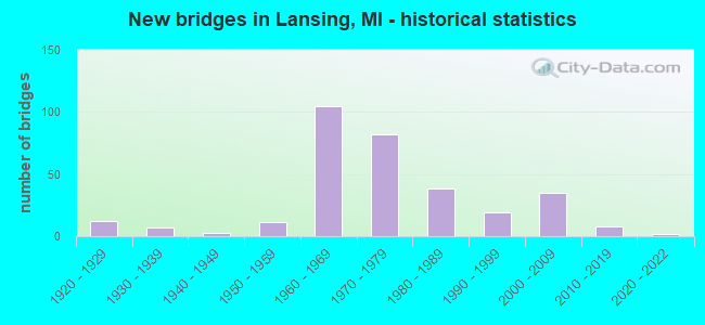
- New bridges - historical statistics
- 121920-1929
- 71930-1939
- 31940-1949
- 111950-1959
- 1051960-1969
- 821970-1979
- 381980-1989
- 191990-1999
- 352000-2009
- 82010-2019
- 22020-2022
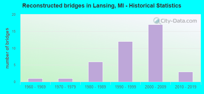
- Reconstructed bridges - Historical Statistics
- 11960-1969
- 11970-1979
- 61980-1989
- 121990-1999
- 172000-2009
- 32010-2019
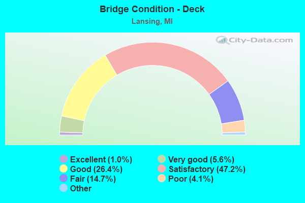
- Bridge Condition - Deck
- 1.0%Excellent
- 5.6%Very good
- 26.4%Good
- 47.2%Satisfactory
- 14.7%Fair
- 4.1%Poor
- 1.0%Serious
- 0.5%Critical
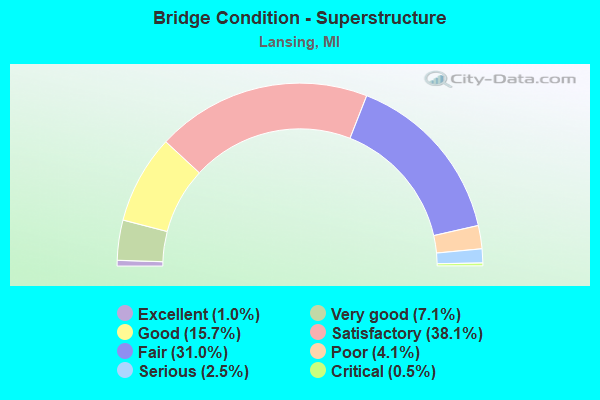
- Bridge Condition - Superstructure
- 1.0%Excellent
- 7.1%Very good
- 15.7%Good
- 38.1%Satisfactory
- 31.0%Fair
- 4.1%Poor
- 2.5%Serious
- 0.5%Critical
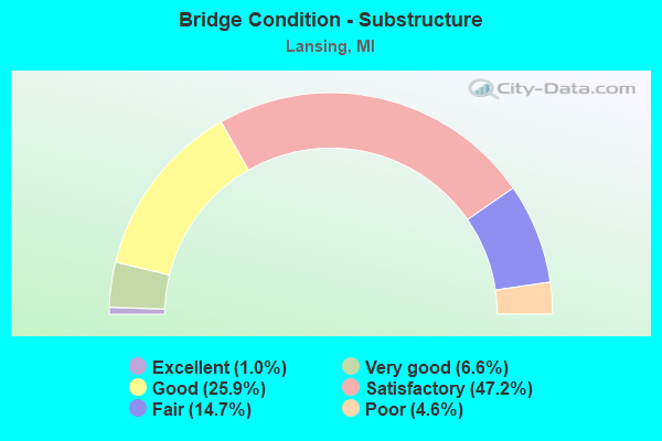
- Bridge Condition - Substructure
- 1.0%Excellent
- 6.6%Very good
- 25.9%Good
- 47.2%Satisfactory
- 14.7%Fair
- 4.6%Poor
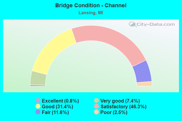
- Bridge Condition - Channel
- 0.8%Excellent
- 7.4%Very good
- 31.4%Good
- 46.3%Satisfactory
- 11.6%Fair
- 2.5%Poor
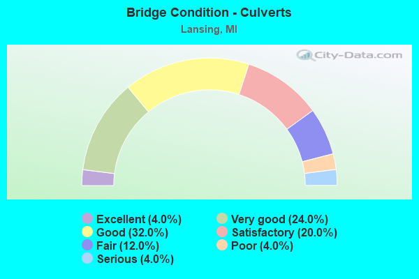
- Bridge Condition - Culverts
- 4.0%Excellent
- 24.0%Very good
- 32.0%Good
- 20.0%Satisfactory
- 12.0%Fair
- 4.0%Poor
- 4.0%Serious
Find on map >> Show street view
Structure Number: 2112, Location: 0.4 MI N OF US-2 (Lat: 45.930533, Lng: -86.973850), Route carried "on" structure: US 41, Year Built: 1993, Status: Open, Structure Length: 1.22m (4.00ft), Average Daily Traffic: 2,760 (year 2007), Truck Traffic: 12%, Average Future Daily Traffic: 4,216 (year 2018), Design Load: HS 25 or greater, Features Intersected: TACOOSH CREEK
Minimum Vertical Clearance: 30.48m (100.00ft), Kilometerpoint: 0.439, Lanes on structure: 2, Base Highway Network: Yes (Inventory Route: 135, Subroute: 5), Owner: State Highway Agency, Approaching Roadway Width: 11.6m (38.1ft), Skew: 1 degrees, Material/Design: Prestressed concrete, Design/Construction: Box Beam or Girders - Multiple, Number Of Spans In Main Unit: 1, Length of Maximum Span: 10.9m (35.8ft), Curb-To-Curb Width: 14.6m (47.9ft), Out-to-Out Width: 15.6m (51.2ft)
Condition: Deck: Good, Superstructure: Good, Substructure: Good, Channel: Good, Operating Rating: 94.0 metric tons, Method Used To Determine Operating Rating: Load Factor (LF) rating reported by rating factor (RF) method using MS18 loading, Inventory Rating: 56.4 metric tons, Method Used To Determine Inventory Rating: Load Factor (LF) rating reported by rating factor (RF) method using MS18 loading, Structural Evaluation: Better than present minimum criteria, Deck Geometry: Superior to present desirable criteria, Waterway Adequacy: Better than present minimum criteria, Approach Roadway Alignment: Equal to present desirable criteria, Designated Inspection Frequency: Every 24 months, Inspection Date: September 2021, Deck Structure Type: Concrete Cast-file-Place, Wearing Surface/Protective System: Wearing Surface: Latex Concrete, Deck Protection: Epoxy Coated Reinforcing
Find on map >> Show street view
Structure Number: 2113, Location: 7.2 MI N OF US-2 (Lat: 46.023389, Lng: -86.975811), Route carried "on" structure: US 41, Year Built: 1937, Status: Open, Structure Length: 1.82m (5.97ft), Average Daily Traffic: 2,264 (year 2007), Truck Traffic: 16%, Average Future Daily Traffic: 3,230 (year 2018), Design Load: H 20, Features Intersected: RAPID RIVER
Minimum Vertical Clearance: 30.48m (100.00ft), Kilometerpoint: 10.981, Lanes on structure: 2, Base Highway Network: Yes (Inventory Route: 135, Subroute: 5), Owner: State Highway Agency, Approaching Roadway Width: 11.6m (38.1ft), Material/Design: Steel, Design/Construction: Stringer/Multi-beam, Number Of Spans In Main Unit: 1, Length of Maximum Span: 18.2m (59.7ft), Curb-To-Curb Width: 10.7m (35.1ft), Out-to-Out Width: 11.6m (38.1ft)
Condition: Deck: Satisfactory, Superstructure: Satisfactory, Substructure: Satisfactory, Channel: Good, Operating Rating: 54.1 metric tons, Method Used To Determine Operating Rating: Load Factor (LF) rating reported by rating factor (RF) method using MS18 loading, Inventory Rating: 32.4 metric tons, Method Used To Determine Inventory Rating: Load Factor (LF) rating reported by rating factor (RF) method using MS18 loading, Structural Evaluation: Equal to present minimum criteria, Deck Geometry: Somewhat better than minimum adequacy, Waterway Adequacy: Better than present minimum criteria, Approach Roadway Alignment: Better than present minimum criteria, Designated Inspection Frequency: Every 24 months, Inspection Date: September 2021, Deck Structure Type: Concrete Cast-file-Place, Wearing Surface/Protective System: Wearing Surface: Bituminous, Membrane: Built-up
Find on map >> Show street view
Structure Number: 2264, Location: 4.0 MI NE OF POTTERVILLE (Lat: 42.669531, Lng: -84.682033), Route carried "on" structure: Interstate 69, Year Built: 1989, Status: Open, Structure Length: 10.64m (34.91ft), Average Daily Traffic: 15,001 (year 2007), Truck Traffic: 21%, Average Future Daily Traffic: 15,406 (year 2018), Design Load: HS 25 or greater, Features Intersected: GTW RR& BILLWOOD HWY
Minimum Vertical Clearance: 30.48m (100.00ft), Kilometerpoint: 38.387, Lanes on structure: 2, Lanes under structure: 2, Base Highway Network: Yes (Inventory Route: 56, Subroute: 1), Owner: State Highway Agency, Approaching Roadway Width: 13.4m (44.0ft), Material/Design: Steel continuous, Design/Construction: Stringer/Multi-beam, Number Of Spans In Main Unit: 2, Length of Maximum Span: 55.4m (181.8ft), Curb-To-Curb Width: 13.4m (44.0ft), Out-to-Out Width: 14.4m (47.2ft)
Condition: Deck: Satisfactory, Superstructure: Satisfactory, Substructure: Satisfactory, Operating Rating: 73.5 metric tons, Method Used To Determine Operating Rating: Load Factor (LF) rating reported by rating factor (RF) method using MS18 loading, Inventory Rating: 44.1 metric tons, Method Used To Determine Inventory Rating: Load Factor (LF) rating reported by rating factor (RF) method using MS18 loading, Structural Evaluation: Equal to present minimum criteria, Deck Geometry: Superior to present desirable criteria, Underclear: Superior to present desirable criteria, Approach Roadway Alignment: Equal to present desirable criteria, Designated Inspection Frequency: Every 24 months, Inspection Date: June 2021, Deck Structure Type: Concrete Cast-file-Place, Wearing Surface/Protective System: Wearing Surface: Epoxy Overlay, Deck Protection: Epoxy Coated Reinforcing
Find on map >> Show street view
Structure Number: 2265, Location: 4.0 MI NE OF POTTERVILLE (Lat: 42.669267, Lng: -84.682525), Route carried "on" structure: Interstate 69, Year Built: 1989, Status: Open, Structure Length: 7.56m (24.80ft), Average Daily Traffic: 15,001 (year 2007), Truck Traffic: 21%, Average Future Daily Traffic: 15,406 (year 2018), Design Load: HS 25 or greater, Features Intersected: GTW RR& BILLWOOD HWY
Minimum Vertical Clearance: 30.48m (100.00ft), Kilometerpoint: 38.386, Lanes on structure: 2, Lanes under structure: 2, Base Highway Network: Yes (Inventory Route: 56, Subroute: 1), Owner: State Highway Agency, Approaching Roadway Width: 13.4m (44.0ft), Material/Design: Steel, Design/Construction: Stringer/Multi-beam, Number Of Spans In Main Unit: 3, Length of Maximum Span: 44.8m (147.0ft), Curb-To-Curb Width: 13.4m (44.0ft), Out-to-Out Width: 14.4m (47.2ft)
Condition: Deck: Satisfactory, Superstructure: Satisfactory, Substructure: Satisfactory, Operating Rating: 71.0 metric tons, Method Used To Determine Operating Rating: Load Factor (LF) rating reported by rating factor (RF) method using MS18 loading, Inventory Rating: 42.4 metric tons, Method Used To Determine Inventory Rating: Load Factor (LF) rating reported by rating factor (RF) method using MS18 loading, Structural Evaluation: Equal to present minimum criteria, Deck Geometry: Superior to present desirable criteria, Underclear: Meets minimum limits, Approach Roadway Alignment: Equal to present desirable criteria, Designated Inspection Frequency: Every 24 months, Inspection Date: June 2021, Deck Structure Type: Concrete Cast-file-Place, Wearing Surface/Protective System: Wearing Surface: Epoxy Overlay, Deck Protection: Epoxy Coated Reinforcing
Find on map >> Show street view
Structure Number: 2277, Location: 3.2 MI NE OF POTTERVILLE (Lat: 42.658603, Lng: -84.683878), Route carried "on" structure: US 27, Year Built: 1989, Status: Open, Structure Length: 11.22m (36.81ft), Average Daily Traffic: 10,600 (year 2015), Truck Traffic: 11%, Average Future Daily Traffic: 12,190 (year 2035), Design Load: HS 20, Features Intersected: I-69, Facility Carried by Structure: LANSING ROAD
Minimum Vertical Clearance: 30.48m (100.00ft), Kilometerpoint: 16.512, Lanes on structure: 5, Lanes under structure: 5, Base Highway Network: Yes (Inventory Route: 56, Subroute: 6), Owner: State Highway Agency, Approaching Roadway Width: 21.9m (71.9ft), Skew: 4 degrees, Material/Design: Steel continuous, Design/Construction: Stringer/Multi-beam, Number Of Spans In Main Unit: 2, Length of Maximum Span: 56.1m (184.1ft), Curb-To-Curb Width: 20.7m (67.9ft), Out-to-Out Width: 21.7m (71.2ft)
Condition: Deck: Good, Superstructure: Fair, Substructure: Satisfactory, Operating Rating: 56.1 metric tons, Method Used To Determine Operating Rating: Load Factor (LF) rating reported by rating factor (RF) method using MS18 loading, Inventory Rating: 33.7 metric tons, Method Used To Determine Inventory Rating: Load Factor (LF) rating reported by rating factor (RF) method using MS18 loading, Structural Evaluation: Somewhat better than minimum adequacy, Deck Geometry: Somewhat better than minimum adequacy, Underclear: Somewhat better than minimum adequacy, Approach Roadway Alignment: Equal to present desirable criteria, Designated Inspection Frequency: Every 24 months, Inspection Date: June 2021, Deck Structure Type: Concrete Cast-file-Place, Wearing Surface/Protective System: Wearing Surface: Latex Concrete, Deck Protection: Epoxy Coated Reinforcing
Find on map >> Show street view
Structure Number: 2279, Location: 2.0 MI S I-496 (Lat: 42.689786, Lng: -84.667339), Route carried "on" structure: Interstate 69, Year Built: 1989, Status: Open, Structure Length: 9.39m (30.81ft), Average Daily Traffic: 15,001 (year 2007), Truck Traffic: 21%, Average Future Daily Traffic: 15,406 (year 2018), Design Load: HS 25 or greater, Features Intersected: I-96
Minimum Vertical Clearance: 30.48m (100.00ft), Kilometerpoint: 41.091, Lanes on structure: 2, Lanes under structure: 4, Base Highway Network: Yes (Inventory Route: 56, Subroute: 1), Owner: State Highway Agency, Approaching Roadway Width: 14.6m (47.9ft), Material/Design: Steel, Design/Construction: Stringer/Multi-beam, Number Of Spans In Main Unit: 4, Length of Maximum Span: 34.4m (112.9ft), Curb-To-Curb Width: 13.9m (45.6ft), Out-to-Out Width: 14.9m (48.9ft)
Condition: Deck: Satisfactory, Superstructure: Fair, Substructure: Satisfactory, Operating Rating: 68.0 metric tons, Method Used To Determine Operating Rating: Load Factor (LF) rating reported by rating factor (RF) method using MS18 loading, Inventory Rating: 40.5 metric tons, Method Used To Determine Inventory Rating: Load Factor (LF) rating reported by rating factor (RF) method using MS18 loading, Structural Evaluation: Somewhat better than minimum adequacy, Deck Geometry: Superior to present desirable criteria, Underclear: Equal to present minimum criteria, Approach Roadway Alignment: Equal to present desirable criteria, Designated Inspection Frequency: Every 24 months, Inspection Date: June 2021, Deck Structure Type: Concrete Cast-file-Place, Wearing Surface/Protective System: Wearing Surface: Latex Concrete, Deck Protection: Epoxy Coated Reinforcing
Find on map >> Show street view
Structure Number: 228, Location: 2.0 MI S I-496 (Lat: 42.690061, Lng: -84.667500), Route carried "on" structure: Interstate 69, Year Built: 1989, Status: Open, Structure Length: 9.60m (31.50ft), Average Daily Traffic: 15,001 (year 2007), Truck Traffic: 21%, Average Future Daily Traffic: 15,406 (year 2018), Design Load: HS 25 or greater, Features Intersected: I-96
Minimum Vertical Clearance: 30.48m (100.00ft), Kilometerpoint: 41.165, Lanes on structure: 1, Lanes under structure: 5, Base Highway Network: Yes (Inventory Route: 56, Subroute: 1), Owner: State Highway Agency, Approaching Roadway Width: 14.6m (47.9ft), Skew: 3 degrees, Material/Design: Steel, Design/Construction: Stringer/Multi-beam, Number Of Spans In Main Unit: 4, Length of Maximum Span: 35.6m (116.8ft), Curb-To-Curb Width: 8.5m (27.9ft), Out-to-Out Width: 9.5m (31.2ft)
Condition: Deck: Satisfactory, Superstructure: Fair, Substructure: Satisfactory, Operating Rating: 67.7 metric tons, Method Used To Determine Operating Rating: Load Factor (LF) rating reported by rating factor (RF) method using MS18 loading, Inventory Rating: 40.2 metric tons, Method Used To Determine Inventory Rating: Load Factor (LF) rating reported by rating factor (RF) method using MS18 loading, Structural Evaluation: Somewhat better than minimum adequacy, Deck Geometry: Meets minimum limits, Underclear: Better than present minimum criteria, Approach Roadway Alignment: Equal to present minimum criteria, Designated Inspection Frequency: Every 24 months, Inspection Date: June 2021, Deck Structure Type: Concrete Cast-file-Place, Wearing Surface/Protective System: Wearing Surface: Latex Concrete, Deck Protection: Epoxy Coated Reinforcing
Find on map >> Show street view
Structure Number: 2281, Location: 1.5 MI S I-496 (Lat: 42.697561, Lng: -84.667700), Route carried "on" structure: County highway , Year Built: 1989, Status: Open, Structure Length: 5.97m (19.59ft), Average Daily Traffic: 1,500 (year 1982), Truck Traffic: 3%, Average Future Daily Traffic: 1,500 (year 1977), Design Load: HS 25 or greater, Features Intersected: I-69 NB, Facility Carried by Structure: MILLET ROAD
Minimum Vertical Clearance: 30.48m (100.00ft), Kilometerpoint: 0.624, Lanes on structure: 4, Lanes under structure: 2, Owner: State Highway Agency, Approaching Roadway Width: 14.6m (47.9ft), Skew: 3 degrees, Material/Design: Steel, Design/Construction: Stringer/Multi-beam, Number Of Spans In Main Unit: 3, Length of Maximum Span: 33.8m (110.9ft), Curb or Sidewalk Widths: Left: 0.0m, Right: 1.5m (4.9ft), Curb-To-Curb Width: 15.9m (52.2ft), Out-to-Out Width: 18.6m (61.0ft)
Condition: Deck: Satisfactory, Superstructure: Fair, Substructure: Satisfactory, Operating Rating: 65.8 metric tons, Method Used To Determine Operating Rating: Load Factor (LF) rating reported by rating factor (RF) method using MS18 loading, Inventory Rating: 39.2 metric tons, Method Used To Determine Inventory Rating: Load Factor (LF) rating reported by rating factor (RF) method using MS18 loading, Structural Evaluation: Somewhat better than minimum adequacy, Deck Geometry: Meets minimum limits, Underclear: Equal to present minimum criteria, Approach Roadway Alignment: Equal to present desirable criteria, Designated Inspection Frequency: Every 24 months, Inspection Date: June 2021, Deck Structure Type: Concrete Cast-file-Place, Wearing Surface/Protective System: Wearing Surface: Integral Concrete, Deck Protection: Epoxy Coated Reinforcing
Find on map >> Show street view
Structure Number: 2314, Location: @ INGHAM CO LINE (Lat: 42.665583, Lng: -84.603042), Route carried "on" structure: County highway 2003, Year Built: 1962, Status: Open, Structure Length: 6.52m (21.39ft), Average Daily Traffic: 5,200 (year 1988), Average Future Daily Traffic: 5,980 (year 2008), Design Load: HS 20, Features Intersected: I-96, Facility Carried by Structure: WAVERLY RD
Minimum Vertical Clearance: 30.48m (100.00ft), Kilometerpoint: 9.264, Lanes on structure: 2, Lanes under structure: 4, Base Highway Network: Yes (Inventory Route: 57, Subroute: 8), Owner: State Highway Agency, Approaching Roadway Width: 10.9m (35.8ft), Material/Design: Prestressed concrete, Design/Construction: Stringer/Multi-beam, Number Of Spans In Main Unit: 4, Length of Maximum Span: 21.3m (69.9ft), Curb-To-Curb Width: 9.3m (30.5ft), Out-to-Out Width: 10.6m (34.8ft)
Condition: Deck: Satisfactory, Superstructure: Satisfactory, Substructure: Satisfactory, Operating Rating: 56.4 metric tons, Method Used To Determine Operating Rating: Load Factor (LF) rating reported by rating factor (RF) method using MS18 loading, Inventory Rating: 33.7 metric tons, Method Used To Determine Inventory Rating: Load Factor (LF) rating reported by rating factor (RF) method using MS18 loading, Structural Evaluation: Equal to present minimum criteria, Deck Geometry: Meets minimum limits, Underclear: Meets minimum limits, Approach Roadway Alignment: Equal to present minimum criteria, Designated Inspection Frequency: Every 24 months, Inspection Date: July 2021, Deck Structure Type: Concrete Cast-file-Place, Wearing Surface/Protective System: Wearing Surface: Monolithic Concrete
Find on map >> Show street view
Structure Number: 232, Location: 0.6 MI NW OF LANSING RD (Lat: 42.682508, Lng: -84.658503), Route carried "on" structure: Interstate 96, Year Built: 1962, Status: Open, Structure Length: 5.37m (17.62ft), Average Daily Traffic: 17,748 (year 2007), Truck Traffic: 22%, Average Future Daily Traffic: 15,769 (year 2018), Design Load: HS 20+Mod, Features Intersected: GTW RR
Minimum Vertical Clearance: 30.48m (100.00ft), Kilometerpoint: 10.025, Lanes on structure: 2, Base Highway Network: Yes (Inventory Route: 56, Subroute: 6), Owner: State Highway Agency, Approaching Roadway Width: 12.8m (42.0ft), Skew: 1 degrees, Material/Design: Steel, Design/Construction: Stringer/Multi-beam, Number Of Spans In Main Unit: 3, Length of Maximum Span: 21.3m (69.9ft), Curb-To-Curb Width: 12.0m (39.4ft), Out-to-Out Width: 13.3m (43.6ft)
Condition: Deck: Satisfactory, Superstructure: Fair, Substructure: Poor, Operating Rating: 78.4 metric tons, Method Used To Determine Operating Rating: Load Factor (LF) rating reported by rating factor (RF) method using MS18 loading, Inventory Rating: 47.0 metric tons, Method Used To Determine Inventory Rating: Load Factor (LF) rating reported by rating factor (RF) method using MS18 loading, Structural Evaluation: Meets minimum limits, Deck Geometry: Equal to present minimum criteria, Approach Roadway Alignment: Equal to present desirable criteria, Designated Inspection Frequency: Every 24 months, Inspection Date: July 2021, Deck Structure Type: Concrete Cast-file-Place, Wearing Surface/Protective System: Wearing Surface: Latex Concrete
Find on map >> Show street view
Structure Number: 2321, Location: 0.6 MI NW OF LANSING RD (Lat: 42.681914, Lng: -84.659717), Route carried "on" structure: Interstate 96, Year Built: 1962, Status: Open, Structure Length: 5.27m (17.29ft), Average Daily Traffic: 17,748 (year 2007), Truck Traffic: 22%, Average Future Daily Traffic: 15,769 (year 2018), Design Load: HS 20+Mod, Features Intersected: GTW RR
Minimum Vertical Clearance: 30.48m (100.00ft), Kilometerpoint: 10.025, Lanes on structure: 2, Base Highway Network: Yes (Inventory Route: 56, Subroute: 5), Owner: State Highway Agency, Approaching Roadway Width: 13.1m (43.0ft), Material/Design: Steel, Design/Construction: Stringer/Multi-beam, Number Of Spans In Main Unit: 3, Length of Maximum Span: 21.3m (69.9ft), Curb-To-Curb Width: 12.0m (39.4ft), Out-to-Out Width: 13.3m (43.6ft)
Condition: Deck: Satisfactory, Superstructure: Fair, Substructure: Satisfactory, Operating Rating: 74.5 metric tons, Method Used To Determine Operating Rating: Load Factor (LF) rating reported by rating factor (RF) method using MS18 loading, Inventory Rating: 44.4 metric tons, Method Used To Determine Inventory Rating: Load Factor (LF) rating reported by rating factor (RF) method using MS18 loading, Structural Evaluation: Somewhat better than minimum adequacy, Deck Geometry: Equal to present minimum criteria, Underclear: Better than present minimum criteria, Approach Roadway Alignment: Equal to present desirable criteria, Designated Inspection Frequency: Every 24 months, Inspection Date: July 2021, Bridge Improvement Cost: $99,000, Deck Structure Type: Concrete Cast-file-Place, Wearing Surface/Protective System: Wearing Surface: Latex Concrete
Find on map >> Show street view
Structure Number: 2326, Location: 1.8 MI S OF M-43 (Lat: 42.712044, Lng: -84.668911), Route carried "on" structure: County highway 2382, Year Built: 1962, Year Reconstructed: 1989, Status: Open, Structure Length: 12.15m (39.86ft), Average Daily Traffic: 1,600 (year 1988), Truck Traffic: 3%, Average Future Daily Traffic: 60,600 (year 2010), Design Load: H 20, Features Intersected: I-96 & I-496 RAMP, Facility Carried by Structure: MT HOPE HWY
Minimum Vertical Clearance: 30.48m (100.00ft), Kilometerpoint: 33.757, Lanes on structure: 2, Lanes under structure: 8, Owner: State Highway Agency, Approaching Roadway Width: 11.2m (36.7ft), Material/Design: Prestressed concrete, Design/Construction: Stringer/Multi-beam, Number Of Spans In Main Unit: 6, Length of Maximum Span: 29.5m (96.8ft), Curb-To-Curb Width: 9.0m (29.5ft), Out-to-Out Width: 9.9m (32.5ft)
Condition: Deck: Satisfactory, Superstructure: Satisfactory, Substructure: Satisfactory, Operating Rating: 56.4 metric tons, Method Used To Determine Operating Rating: Load Factor (LF) rating reported by rating factor (RF) method using MS18 loading, Inventory Rating: 30.5 metric tons, Method Used To Determine Inventory Rating: Load Factor (LF) rating reported by rating factor (RF) method using MS18 loading, Structural Evaluation: Equal to present minimum criteria, Deck Geometry: Somewhat better than minimum adequacy, Underclear: Somewhat better than minimum adequacy, Approach Roadway Alignment: Equal to present desirable criteria, Designated Inspection Frequency: Every 24 months, Inspection Date: July 2021, Deck Structure Type: Concrete Cast-file-Place, Wearing Surface/Protective System: Wearing Surface: Epoxy Overlay, Deck Protection: Epoxy Coated Reinforcing
Find on map >> Show street view
Structure Number: 2327, Location: 3.0 MI S OF M-43 (Lat: 42.697561, Lng: -84.669556), Route carried "on" structure: County highway , Year Built: 2001, Status: Open, Structure Length: 8.00m (26.25ft), Average Daily Traffic: 150 (year 1988), Truck Traffic: 3%, Average Future Daily Traffic: 50 (year 1977), Design Load: HS 20, Features Intersected: I-96, Facility Carried by Structure: MILLETT RD
Minimum Vertical Clearance: 30.48m (100.00ft), Kilometerpoint: 0.454, Lanes on structure: 4, Lanes under structure: 5, Owner: State Highway Agency, Approaching Roadway Width: 14.6m (47.9ft), Material/Design: Prestressed concrete, Design/Construction: Box Beam or Girders - Multiple, Number Of Spans In Main Unit: 4, Length of Maximum Span: 29.3m (96.1ft), Curb or Sidewalk Widths: Left: 0.0m, Right: 1.7m (5.6ft), Curb-To-Curb Width: 15.9m (52.2ft), Out-to-Out Width: 18.9m (62.0ft)
Condition: Deck: Satisfactory, Superstructure: Satisfactory, Substructure: Good, Operating Rating: 77.1 metric tons, Method Used To Determine Operating Rating: Load Factor (LF) rating reported by rating factor (RF) method using MS18 loading, Inventory Rating: 40.2 metric tons, Method Used To Determine Inventory Rating: Load Factor (LF) rating reported by rating factor (RF) method using MS18 loading, Structural Evaluation: Equal to present minimum criteria, Deck Geometry: Meets minimum limits, Underclear: Better than present minimum criteria, Approach Roadway Alignment: Equal to present minimum criteria, Designated Inspection Frequency: Every 24 months, Inspection Date: July 2021, Deck Structure Type: Concrete Cast-file-Place, Wearing Surface/Protective System: Wearing Surface: Monolithic Concrete, Deck Protection: Epoxy Coated Reinforcing
Find on map >> Show street view
Structure Number: 2331, Location: I-96 & LANSING RD (Lat: 42.676333, Lng: -84.653244), Route carried "on" structure: Interstate 96, Year Built: 2001, Status: Open, Structure Length: 7.34m (24.08ft), Average Daily Traffic: 21,057 (year 2007), Truck Traffic: 16%, Average Future Daily Traffic: 24,047 (year 2018), Design Load: HS 20+Mod, Features Intersected: LANSING RD
Minimum Vertical Clearance: 30.48m (100.00ft), Kilometerpoint: 10.839, Lanes on structure: 3, Lanes under structure: 6, Base Highway Network: Yes (Inventory Route: 56, Subroute: 5), Owner: State Highway Agency, Approaching Roadway Width: 15.0m (49.2ft), Material/Design: Prestressed concrete, Design/Construction: Box Beam or Girders - Multiple, Number Of Spans In Main Unit: 4, Length of Maximum Span: 26.0m (85.3ft), Curb-To-Curb Width: 18.0m (59.1ft), Out-to-Out Width: 19.0m (62.3ft)
Condition: Deck: Satisfactory, Superstructure: Satisfactory, Substructure: Good, Operating Rating: 80.7 metric tons, Method Used To Determine Operating Rating: Load Factor (LF) rating reported by rating factor (RF) method using MS18 loading, Inventory Rating: 41.1 metric tons, Method Used To Determine Inventory Rating: Load Factor (LF) rating reported by rating factor (RF) method using MS18 loading, Structural Evaluation: Equal to present minimum criteria, Deck Geometry: Better than present minimum criteria, Underclear: Superior to present desirable criteria, Approach Roadway Alignment: Equal to present desirable criteria, Designated Inspection Frequency: Every 24 months, Inspection Date: July 2021, Deck Structure Type: Concrete Cast-file-Place, Wearing Surface/Protective System: Wearing Surface: Monolithic Concrete, Deck Protection: Epoxy Coated Reinforcing
Find on map >> Show street view
Structure Number: 2334, Location: STATE SECONDARY COMPLEX (Lat: 42.673539, Lng: -84.674900), Route carried "on" structure: ServiceState lands road 23, Year Built: 1973, Year Reconstructed: 2007, Status: Open, Structure Length: 5.48m (17.98ft), Average Daily Traffic: 3,000 (year 1988), Truck Traffic: 3%, Average Future Daily Traffic: 7,100 (year 2022), Design Load: HS 20, Features Intersected: GTW RR, Facility Carried by Structure: CROWNER RD
Minimum Vertical Clearance: 30.48m (100.00ft), Kilometerpoint: 1.176, Lanes on structure: 2, Owner: State Agenciy, Approaching Roadway Width: 12.2m (40.0ft), Skew: 5 degrees, Material/Design: Steel, Design/Construction: Stringer/Multi-beam, Number Of Spans In Main Unit: 3, Length of Maximum Span: 26.5m (86.9ft), Curb or Sidewalk Widths: Left: 1.5m (4.9ft), Right: 0.0m, Curb-To-Curb Width: 8.7m (28.5ft), Out-to-Out Width: 11.0m (36.1ft)
Condition: Deck: Satisfactory, Superstructure: Satisfactory, Substructure: Satisfactory, Operating Rating: 73.5 metric tons, Method Used To Determine Operating Rating: Load Factor (LF), Inventory Rating: 44.0 metric tons, Method Used To Determine Inventory Rating: Load Factor (LF), Structural Evaluation: Equal to present minimum criteria, Deck Geometry: Meets minimum limits, Approach Roadway Alignment: Equal to present minimum criteria, Designated Inspection Frequency: Every 24 months, Inspection Date: September 2021, Deck Structure Type: Concrete Cast-file-Place, Wearing Surface/Protective System: Wearing Surface: Epoxy Overlay
Find on map >> Show street view
Structure Number: 2409, Location: 4 MI S OF SUNFIELD (Lat: 42.697792, Lng: -85.001508), Route carried "on" structure: County highway , Year Built: 1921, Status: Posted for load, Structure Length: 0.94m (3.08ft), Average Daily Traffic: 72 (year 2010), Average Future Daily Traffic: 300 (year 2013), Features Intersected: SEBEWA CREEK, Facility Carried by Structure: BISMARK HWY
Minimum Vertical Clearance: 30.48m (100.00ft), Kilometerpoint: 6.047, Lanes on structure: 2, Owner: County Highway Agency, Approaching Roadway Width: 7.0m (23.0ft), Skew: 4 degrees, Material/Design: Steel, Design/Construction: Stringer/Multi-beam, Number Of Spans In Main Unit: 1, Length of Maximum Span: 8.2m (26.9ft), Curb-To-Curb Width: 5.0m (16.4ft), Out-to-Out Width: 5.5m (18.0ft)
Condition: Deck: Satisfactory, Superstructure: Poor, Substructure: Fair, Channel: Satisfactory, Operating Rating: 27.9 metric tons, Method Used To Determine Operating Rating: Load Factor (LF) rating reported by rating factor (RF) method using MS18 loading, Inventory Rating: 16.5 metric tons, Method Used To Determine Inventory Rating: Load Factor (LF) rating reported by rating factor (RF) method using MS18 loading, Structural Evaluation: Meets minimum limits, Deck Geometry: High priority of corrective action, Waterway Adequacy: Equal to present desirable criteria, Approach Roadway Alignment: Better than present minimum criteria, Bridge Posting: Required (Relationship of Operating Rating to Maximum Legal Load: > 39.9% below), Length Of Structure Improvement: 1.13m (3.71ft), Designated Inspection Frequency: Every 12 months, Inspection Date: April 2021, Bridge Improvement Cost: $110,000, Roadway Improvement Cost: $30,000, Total Project Cost: $180,000, Deck Structure Type: Concrete Cast-file-Place, Wearing Surface/Protective System: Wearing Surface: Monolithic Concrete
Find on map >> Show street view
Structure Number: 2447, Location: 0.4 MI S OF CONWAY (Lat: 45.411633, Lng: -84.866392), Route carried "on" structure: US 31, Year Built: 1930, Status: Open, Structure Length: 0.61m (2.00ft), Average Daily Traffic: 14,853 (year 2007), Truck Traffic: 3%, Average Future Daily Traffic: 19,013 (year 2018), Design Load: HS 20+Mod, Features Intersected: CROOKED LAKE OUTLET
Minimum Vertical Clearance: 30.48m (100.00ft), Kilometerpoint: 8.834, Lanes on structure: 2, Base Highway Network: Yes (Inventory Route: 116, Subroute: 7), Owner: State Highway Agency, Approaching Roadway Width: 11.0m (36.1ft), Material/Design: Concrete, Design/Construction: Tee Beam, Number Of Spans In Main Unit: 1, Length of Maximum Span: 5.7m (18.7ft), Curb-To-Curb Width: 9.8m (32.2ft), Out-to-Out Width: 10.9m (35.8ft)
Condition: Deck: Satisfactory, Superstructure: Satisfactory, Substructure: Satisfactory, Channel: Fair, Operating Rating: 79.1 metric tons, Method Used To Determine Operating Rating: Load Factor (LF) rating reported by rating factor (RF) method using MS18 loading, Inventory Rating: 47.3 metric tons, Method Used To Determine Inventory Rating: Load Factor (LF) rating reported by rating factor (RF) method using MS18 loading, Structural Evaluation: Equal to present minimum criteria, Deck Geometry: Meets minimum limits, Waterway Adequacy: Equal to present minimum criteria, Approach Roadway Alignment: Equal to present minimum criteria, Designated Inspection Frequency: Every 24 months, Inspection Date: July 2021, Wearing Surface/Protective System: Wearing Surface: Bituminous
Find on map >> Show street view
Structure Number: 2491, Location: 0.4 MI N OF M-57 (Lat: 43.183036, Lng: -83.768989), Route carried "on" structure: Interstate 75, Year Built: 1958, Year Reconstructed: 2004, Status: Open, Structure Length: 4.11m (13.48ft), Average Daily Traffic: 28,043 (year 2007), Truck Traffic: 15%, Average Future Daily Traffic: 65,715 (year 2018), Design Load: HS 20, Features Intersected: PINE RUN CREEK
Minimum Vertical Clearance: 30.48m (100.00ft), Kilometerpoint: 40.628, Lanes on structure: 4, Base Highway Network: Yes (Inventory Route: 149, Subroute: 4), Owner: State Highway Agency, Approaching Roadway Width: 21.2m (69.6ft), Skew: 13 degrees, Material/Design: Concrete, Design/Construction: Tee Beam, Number Of Spans In Main Unit: 3, Length of Maximum Span: 13.7m (44.9ft), Curb-To-Curb Width: 24.7m (81.0ft), Out-to-Out Width: 25.2m (82.7ft)
Condition: Deck: Satisfactory, Superstructure: Fair, Substructure: Fair, Channel: Satisfactory, Operating Rating: 46.7 metric tons, Method Used To Determine Operating Rating: Load Factor (LF) rating reported by rating factor (RF) method using MS18 loading, Inventory Rating: 28.2 metric tons, Method Used To Determine Inventory Rating: Load Factor (LF) rating reported by rating factor (RF) method using MS18 loading, Structural Evaluation: Somewhat better than minimum adequacy, Deck Geometry: Superior to present desirable criteria, Waterway Adequacy: Equal to present desirable criteria, Approach Roadway Alignment: Equal to present minimum criteria, Designated Inspection Frequency: Every 24 months, Inspection Date: October 2020, Deck Structure Type: Concrete Cast-file-Place, Wearing Surface/Protective System: Wearing Surface: Latex Concrete
Find on map >> Show street view
Structure Number: 2577, Location: 2.6 MI W OF M-15 (Lat: 43.016014, Lng: -83.568783), Route carried "on" structure: Interstate 69, Year Built: 1970, Status: Open, Structure Length: 2.53m (8.30ft), Average Daily Traffic: 28,913 (year 2007), Truck Traffic: 10%, Average Future Daily Traffic: 76,500 (year 2026), Design Load: HS 20, Features Intersected: KEARSLEY CR
Minimum Vertical Clearance: 30.48m (100.00ft), Kilometerpoint: 31.119, Lanes on structure: 3, Base Highway Network: Yes (Inventory Route: 149, Subroute: 5), Owner: State Highway Agency, Approaching Roadway Width: 16.1m (52.8ft), Skew: 1 degrees, Material/Design: Steel, Design/Construction: Stringer/Multi-beam, Number Of Spans In Main Unit: 1, Length of Maximum Span: 25.3m (83.0ft), Curb or Sidewalk Widths: Left: 0.6m (2.0ft), Right: 0.6m (2.0ft), Curb-To-Curb Width: 15.6m (51.2ft), Out-to-Out Width: 16.8m (55.1ft)
Condition: Deck: Satisfactory, Superstructure: Satisfactory, Substructure: Satisfactory, Channel: Satisfactory, Operating Rating: 70.3 metric tons, Method Used To Determine Operating Rating: Load Factor (LF) rating reported by rating factor (RF) method using MS18 loading, Inventory Rating: 42.1 metric tons, Method Used To Determine Inventory Rating: Load Factor (LF) rating reported by rating factor (RF) method using MS18 loading, Structural Evaluation: Equal to present minimum criteria, Deck Geometry: Somewhat better than minimum adequacy, Waterway Adequacy: Equal to present desirable criteria, Approach Roadway Alignment: Equal to present desirable criteria, Designated Inspection Frequency: Every 24 months, Inspection Date: August 2020, Deck Structure Type: Concrete Cast-file-Place, Wearing Surface/Protective System: Wearing Surface: Monolithic Concrete
Find on map >> Show street view
Structure Number: 2625, Location: @ OAKLAND COUNTY LINE (Lat: 42.873575, Lng: -83.596739), Route carried "on" structure: State highway 54, Year Built: 1962, Year Reconstructed: 1980, Status: Open, Structure Length: 9.42m (30.91ft), Average Daily Traffic: 8,800 (year 1995), Truck Traffic: 5%, Average Future Daily Traffic: 999,999 (year 2015), Design Load: HS 20+Mod, Features Intersected: I-75
Minimum Vertical Clearance: 30.48m (100.00ft), Kilometerpoint: 0.101, Lanes on structure: 2, Lanes under structure: 5, Base Highway Network: Yes (Inventory Route: 149, Subroute: 2), Owner: State Highway Agency, Approaching Roadway Width: 12.2m (40.0ft), Skew: 5 degrees, Material/Design: Steel, Design/Construction: Stringer/Multi-beam, Number Of Spans In Main Unit: 4, Length of Maximum Span: 30.4m (99.7ft), Curb-To-Curb Width: 10.0m (32.8ft), Out-to-Out Width: 11.2m (36.7ft)
Condition: Deck: Satisfactory, Superstructure: Fair, Substructure: Satisfactory, Operating Rating: 55.7 metric tons, Method Used To Determine Operating Rating: Load Factor (LF) rating reported by rating factor (RF) method using MS18 loading, Inventory Rating: 33.4 metric tons, Method Used To Determine Inventory Rating: Load Factor (LF) rating reported by rating factor (RF) method using MS18 loading, Structural Evaluation: Somewhat better than minimum adequacy, Deck Geometry: Meets minimum limits, Underclear: High priority of corrective action, Approach Roadway Alignment: Equal to present desirable criteria, Designated Inspection Frequency: Every 24 months, Inspection Date: August 2020, Bridge Improvement Cost: $208,000, Roadway Improvement Cost: $11,000, Total Project Cost: $125,000, Deck Structure Type: Concrete Cast-file-Place, Wearing Surface/Protective System: Wearing Surface: Epoxy Overlay
Find on map >> Show street view
Structure Number: 2626, Location: 1.2 MI NW OF OAKLAND COL (Lat: 42.886956, Lng: -83.620186), Route carried "on" structure: County highway 2002, Year Built: 1962, Status: Open, Structure Length: 8.90m (29.20ft), Average Daily Traffic: 9,300 (year 2011), Truck Traffic: 3%, Average Future Daily Traffic: 9,200 (year 2016), Design Load: H 15, Features Intersected: I-75, Facility Carried by Structure: BALDWIN RD
Minimum Vertical Clearance: 30.48m (100.00ft), Kilometerpoint: 25.113, Lanes on structure: 2, Lanes under structure: 4, Owner: State Highway Agency, Approaching Roadway Width: 8.5m (27.9ft), Skew: 4 degrees, Material/Design: Steel, Design/Construction: Stringer/Multi-beam, Number Of Spans In Main Unit: 4, Length of Maximum Span: 29.8m (97.8ft), Curb-To-Curb Width: 8.9m (29.2ft), Out-to-Out Width: 9.9m (32.5ft)
Condition: Deck: Fair, Superstructure: Fair, Substructure: Satisfactory, Operating Rating: 54.1 metric tons, Method Used To Determine Operating Rating: Load Factor (LF) rating reported by rating factor (RF) method using MS18 loading, Inventory Rating: 32.4 metric tons, Method Used To Determine Inventory Rating: Load Factor (LF) rating reported by rating factor (RF) method using MS18 loading, Structural Evaluation: Somewhat better than minimum adequacy, Deck Geometry: Meets minimum limits, Underclear: Meets minimum limits, Approach Roadway Alignment: Somewhat better than minimum adequacy, Designated Inspection Frequency: Every 14 months, Inspection Date: May 2021, Deck Structure Type: Concrete Cast-file-Place, Wearing Surface/Protective System: Wearing Surface: Epoxy Overlay
Find on map >> Show street view
Structure Number: 2627, Location: 2.2 MI NW OF OAKLAND COL (Lat: 42.895658, Lng: -83.632419), Route carried "on" structure: County highway 2002, Year Built: 1962, Year Reconstructed: 1996, Status: Open, Structure Length: 8.84m (29.00ft), Average Daily Traffic: 12,418 (year 1996), Truck Traffic: 3%, Average Future Daily Traffic: 22,400 (year 2016), Design Load: HS 20, Features Intersected: I-75, Facility Carried by Structure: HOLLY RD
Minimum Vertical Clearance: 30.48m (100.00ft), Kilometerpoint: 2.609, Lanes on structure: 4, Lanes under structure: 6, Owner: State Highway Agency, Approaching Roadway Width: 12.2m (40.0ft), Skew: 2 degrees, Material/Design: Steel, Design/Construction: Stringer/Multi-beam, Number Of Spans In Main Unit: 4, Length of Maximum Span: 25.0m (82.0ft), Curb-To-Curb Width: 24.3m (79.7ft), Out-to-Out Width: 25.4m (83.3ft)
Condition: Deck: Satisfactory, Superstructure: Satisfactory, Substructure: Satisfactory, Operating Rating: 81.0 metric tons, Method Used To Determine Operating Rating: Load Factor (LF) rating reported by rating factor (RF) method using MS18 loading, Inventory Rating: 48.6 metric tons, Method Used To Determine Inventory Rating: Load Factor (LF) rating reported by rating factor (RF) method using MS18 loading, Structural Evaluation: Equal to present minimum criteria, Deck Geometry: Superior to present desirable criteria, Underclear: Meets minimum limits, Approach Roadway Alignment: Equal to present desirable criteria, Designated Inspection Frequency: Every 14 months, Inspection Date: May 2021, Deck Structure Type: Concrete Cast-file-Place, Wearing Surface/Protective System: Wearing Surface: Epoxy Overlay, Deck Protection: Epoxy Coated Reinforcing
Find on map >> Show street view
Structure Number: 2628, Location: 3.0 MI NW OF OAKLAND COL (Lat: 42.902694, Lng: -83.648489), Route carried "on" structure: Interstate 75, Year Built: 1962, Status: Open, Structure Length: 3.67m (12.04ft), Average Daily Traffic: 40,700 (year 2013), Truck Traffic: 6%, Average Future Daily Traffic: 38,551 (year 2018), Design Load: HS 20+Mod, Features Intersected: COOK RD
Minimum Vertical Clearance: 30.48m (100.00ft), Kilometerpoint: 5.354, Lanes on structure: 3, Lanes under structure: 2, Base Highway Network: Yes (Inventory Route: 150, Subroute: 7), Owner: State Highway Agency, Approaching Roadway Width: 16.7m (54.8ft), Skew: 2 degrees, Material/Design: Steel, Design/Construction: Stringer/Multi-beam, Number Of Spans In Main Unit: 3, Length of Maximum Span: 13.7m (44.9ft), Curb-To-Curb Width: 15.4m (50.5ft), Out-to-Out Width: 16.9m (55.4ft)
Condition: Deck: Satisfactory, Superstructure: Fair, Substructure: Good, Operating Rating: 52.5 metric tons, Method Used To Determine Operating Rating: Load Factor (LF) rating reported by rating factor (RF) method using MS18 loading, Inventory Rating: 31.4 metric tons, Method Used To Determine Inventory Rating: Load Factor (LF) rating reported by rating factor (RF) method using MS18 loading, Structural Evaluation: Somewhat better than minimum adequacy, Deck Geometry: Somewhat better than minimum adequacy, Underclear: Meets minimum limits, Approach Roadway Alignment: Equal to present desirable criteria, Length Of Structure Improvement: 3.69m (12.11ft), Designated Inspection Frequency: Every 13 months, Inspection Date: May 2021, Bridge Improvement Cost: $173,000, Roadway Improvement Cost: $19,000, Total Project Cost: $223,000, Deck Structure Type: Concrete Cast-file-Place, Wearing Surface/Protective System: Wearing Surface: Epoxy Overlay
Find on map >> Show street view
Structure Number: 2648, Location: 4.5 MI S OF FLINT (Lat: 42.922706, Lng: -83.681003), Route carried "on" structure: Interstate 475, Year Built: 1971, Status: Open, Structure Length: 5.73m (18.80ft), Average Daily Traffic: 13,158 (year 2007), Truck Traffic: 8%, Average Future Daily Traffic: 17,501 (year 2018), Design Load: HS 20, Features Intersected: I-75 NB
Minimum Vertical Clearance: 30.48m (100.00ft), Kilometerpoint: 0.641, Lanes on structure: 2, Lanes under structure: 2, Base Highway Network: Yes (Inventory Route: 149, Subroute: 4), Owner: State Highway Agency, Approaching Roadway Width: 14.6m (47.9ft), Skew: 5 degrees, Material/Design: Steel, Design/Construction: Stringer/Multi-beam, Number Of Spans In Main Unit: 3, Length of Maximum Span: 32.6m (107.0ft), Curb-To-Curb Width: 12.8m (42.0ft), Out-to-Out Width: 13.3m (43.6ft)
Condition: Deck: Poor, Superstructure: Satisfactory, Substructure: Satisfactory, Operating Rating: 67.1 metric tons, Method Used To Determine Operating Rating: Load Factor (LF) rating reported by rating factor (RF) method using MS18 loading, Inventory Rating: 40.2 metric tons, Method Used To Determine Inventory Rating: Load Factor (LF) rating reported by rating factor (RF) method using MS18 loading, Structural Evaluation: Equal to present minimum criteria, Deck Geometry: Equal to present desirable criteria, Underclear: High priority of corrective action, Approach Roadway Alignment: Equal to present desirable criteria, Designated Inspection Frequency: Every 24 months, Other Special Inspection Frequency: Every 24 months, Inspection Date: January 2021, Other Special Inspection Date: January 2022, Deck Structure Type: Concrete Cast-file-Place, Wearing Surface/Protective System: Wearing Surface: Latex Concrete
Find on map >> Show street view
Structure Number: 2703, Location: E OF SOUTH LEG OF SEYMOUR (Lat: 42.791467, Lng: -83.844647), Route carried "on" structure: County highway 2508, Year Built: 1929, Status: Posted for load, Structure Length: 1.04m (3.41ft), Average Daily Traffic: 10,073 (year 2018), Truck Traffic: 5%, Average Future Daily Traffic: 18,193 (year 2038), Design Load: HS 20+Mod, Features Intersected: LOBDELL LAKE DAM, Facility Carried by Structure: SILVER LAKE ROAD
Minimum Vertical Clearance: 30.48m (100.00ft), Kilometerpoint: 7.904, Lanes on structure: 2, Owner: Local Agency, Maintenance Responsibility: County Highway Agency, Approaching Roadway Width: 13.1m (43.0ft), Material/Design: Concrete, Design/Construction: Tee Beam, Number Of Spans In Main Unit: 1, Length of Maximum Span: 9.7m (31.8ft), Curb or Sidewalk Widths: Left: 3.0m (9.8ft), Right: 3.0m (9.8ft), Curb-To-Curb Width: 9.1m (29.9ft), Out-to-Out Width: 16.1m (52.8ft)
Condition: Deck: Satisfactory, Superstructure: Satisfactory, Substructure: Fair, Channel: Satisfactory, Operating Rating: 25.3 metric tons, Method Used To Determine Operating Rating: Load Factor (LF) rating reported by rating factor (RF) method using MS18 loading, Inventory Rating: 15.2 metric tons, Method Used To Determine Inventory Rating: Load Factor (LF) rating reported by rating factor (RF) method using MS18 loading, Structural Evaluation: High priority of corrective action, Deck Geometry: High priority of corrective action, Waterway Adequacy: Better than present minimum criteria, Approach Roadway Alignment: Equal to present minimum criteria, Bridge Posting: Required (Relationship of Operating Rating to Maximum Legal Load: > 39.9% below), Designated Inspection Frequency: Every 24 months, Underwater Inspection Frequency: Every 24 months, Inspection Date: May 2021, Underwater Inspection Date: May 2021, Deck Structure Type: Concrete Cast-file-Place, Wearing Surface/Protective System: Wearing Surface: Bituminous
Find on map >> Show street view
Structure Number: 2704, Location: BET FENTON & GRAYTRAX RD (Lat: 42.885839, Lng: -83.691339), Route carried "on" structure: County highway 2002, Year Built: 1938, Status: Posted for load, Structure Length: 0.94m (3.08ft), Average Daily Traffic: 12,302 (year 2017), Truck Traffic: 5%, Average Future Daily Traffic: 22,219 (year 2037), Design Load: HS 20+Mod, Features Intersected: SWARTZ CREEK, Facility Carried by Structure: BALDWIN ROAD
Minimum Vertical Clearance: 30.48m (100.00ft), Kilometerpoint: 19.302, Lanes on structure: 2, Owner: County Highway Agency, Approaching Roadway Width: 11.9m (39.0ft), Material/Design: Concrete, Design/Construction: Tee Beam, Number Of Spans In Main Unit: 1, Length of Maximum Span: 8.5m (27.9ft), Curb-To-Curb Width: 9.1m (29.9ft), Out-to-Out Width: 9.8m (32.2ft)
Condition: Deck: Satisfactory, Superstructure: Poor, Substructure: Satisfactory, Channel: Satisfactory, Operating Rating: 25.6 metric tons, Method Used To Determine Operating Rating: Load Factor (LF) rating reported by rating factor (RF) method using MS18 loading, Inventory Rating: 15.2 metric tons, Method Used To Determine Inventory Rating: Load Factor (LF) rating reported by rating factor (RF) method using MS18 loading, Structural Evaluation: High priority of corrective action, Deck Geometry: High priority of corrective action, Waterway Adequacy: Better than present minimum criteria, Approach Roadway Alignment: Equal to present desirable criteria, Bridge Posting: Required (Relationship of Operating Rating to Maximum Legal Load: > 39.9% below), Designated Inspection Frequency: Every 8 months, Inspection Date: Febuary 2022, Deck Structure Type: Concrete Cast-file-Place, Wearing Surface/Protective System: Wearing Surface: Bituminous
Find on map >> Show street view
Structure Number: 2712, Location: BET SAGINAW & CENTER RD (Lat: 42.944650, Lng: -83.645683), Route carried "on" structure: County highway 2002, Year Built: 1995, Status: Open, Structure Length: 1.82m (5.97ft), Average Daily Traffic: 14,407 (year 2018), Truck Traffic: 5%, Average Future Daily Traffic: 26,020 (year 2038), Design Load: HS 20, Features Intersected: THREAD RIVER, Facility Carried by Structure: HILL ROAD
Minimum Vertical Clearance: 30.48m (100.00ft), Kilometerpoint: 17.386, Lanes on structure: 2, Owner: County Highway Agency, Approaching Roadway Width: 11.9m (39.0ft), Material/Design: Prestressed concrete, Design/Construction: Box Beam or Girders - Multiple, Number Of Spans In Main Unit: 1, Length of Maximum Span: 17.0m (55.8ft), Curb-To-Curb Width: 18.9m (62.0ft), Out-to-Out Width: 20.1m (65.9ft)
Condition: Deck: Good, Superstructure: Good, Substructure: Very good, Channel: Very good, Operating Rating: 66.1 metric tons, Method Used To Determine Operating Rating: Load Factor (LF) rating reported by rating factor (RF) method using MS18 loading, Inventory Rating: 39.5 metric tons, Method Used To Determine Inventory Rating: Load Factor (LF) rating reported by rating factor (RF) method using MS18 loading, Structural Evaluation: Better than present minimum criteria, Deck Geometry: Superior to present desirable criteria, Waterway Adequacy: Equal to present minimum criteria, Approach Roadway Alignment: Equal to present desirable criteria, Designated Inspection Frequency: Every 24 months, Inspection Date: November 2020, Deck Structure Type: Concrete Cast-file-Place, Wearing Surface/Protective System: Wearing Surface: Monolithic Concrete, Deck Protection: Epoxy Coated Reinforcing
Find on map >> Show street view
Structure Number: 2732, Location: 1700 FT WEST OF JENNINGS (Lat: 43.148347, Lng: -83.760694), Route carried "on" structure: County highway 2584, Year Built: 1926, Status: Open, Structure Length: 0.82m (2.69ft), Average Daily Traffic: 2,595 (year 2019), Truck Traffic: 5%, Average Future Daily Traffic: 4,687 (year 2039), Design Load: HS 20+Mod, Features Intersected: BRENT RUN, Facility Carried by Structure: DODGE ROAD
Minimum Vertical Clearance: 30.48m (100.00ft), Kilometerpoint: 8.206, Lanes on structure: 2, Owner: County Highway Agency, Approaching Roadway Width: 10.1m (33.1ft), Material/Design: Concrete, Design/Construction: Tee Beam, Number Of Spans In Main Unit: 1, Length of Maximum Span: 7.9m (25.9ft), Curb-To-Curb Width: 7.9m (25.9ft), Out-to-Out Width: 8.6m (28.2ft)
Condition: Deck: Satisfactory, Superstructure: Poor, Substructure: Fair, Channel: Fair, Operating Rating: 40.2 metric tons, Method Used To Determine Operating Rating: Load Factor (LF) rating reported by rating factor (RF) method using MS18 loading, Inventory Rating: 24.0 metric tons, Method Used To Determine Inventory Rating: Load Factor (LF) rating reported by rating factor (RF) method using MS18 loading, Structural Evaluation: Meets minimum limits, Deck Geometry: High priority of corrective action, Waterway Adequacy: Better than present minimum criteria, Approach Roadway Alignment: Equal to present minimum criteria, Designated Inspection Frequency: Every 24 months, Inspection Date: November 2020, Deck Structure Type: Concrete Cast-file-Place, Wearing Surface/Protective System: Wearing Surface: Bituminous
Find on map >> Show street view
Structure Number: 2734, Location: NORTH OF SILVER LAKE RD (Lat: 42.816792, Lng: -83.895303), Route carried "on" structure: County highway 2505, Year Built: 1924, Year Reconstructed: 2010, Status: Open, Structure Length: 1.36m (4.46ft), Average Daily Traffic: 1,618 (year 2018), Truck Traffic: 5%, Average Future Daily Traffic: 2,922 (year 2038), Design Load: HL 93, Features Intersected: SHIAWASSEE RIVER, Facility Carried by Structure: DUFFIELD ROAD
Minimum Vertical Clearance: 30.48m (100.00ft), Kilometerpoint: 3.933, Lanes on structure: 2, Owner: County Highway Agency, Approaching Roadway Width: 11.0m (36.1ft), Material/Design: Prestressed concrete, Design/Construction: Box Beam or Girders - Multiple, Number Of Spans In Main Unit: 1, Length of Maximum Span: 12.5m (41.0ft), Curb-To-Curb Width: 11.6m (38.1ft), Out-to-Out Width: 11.9m (39.0ft)
Condition: Deck: Very good, Superstructure: Very good, Substructure: Good, Channel: Good, Operating Rating: 71.0 metric tons, Method Used To Determine Operating Rating: Load Factor (LF) rating reported by rating factor (RF) method using MS18 loading, Inventory Rating: 42.4 metric tons, Method Used To Determine Inventory Rating: Load Factor (LF) rating reported by rating factor (RF) method using MS18 loading, Structural Evaluation: Better than present minimum criteria, Deck Geometry: Equal to present minimum criteria, Waterway Adequacy: Somewhat better than minimum adequacy, Approach Roadway Alignment: Equal to present desirable criteria, Designated Inspection Frequency: Every 24 months, Inspection Date: November 2020, Deck Structure Type: Concrete Cast-file-Place, Wearing Surface/Protective System: Wearing Surface: Monolithic Concrete, Deck Protection: Epoxy Coated Reinforcing
Find on map >> Show street view
Structure Number: 2743, Location: BET REID & HILL ROAD (Lat: 42.929067, Lng: -83.731064), Route carried "on" structure: County highway 2002, Year Built: 1928, Status: Posted for load, Structure Length: 1.06m (3.48ft), Average Daily Traffic: 5,310 (year 2017), Truck Traffic: 5%, Average Future Daily Traffic: 9,590 (year 2037), Design Load: HS 20+Mod, Features Intersected: SWARTZ CREEK, Facility Carried by Structure: TORREY ROAD
Minimum Vertical Clearance: 30.48m (100.00ft), Kilometerpoint: 13.912, Lanes on structure: 2, Owner: County Highway Agency, Approaching Roadway Width: 9.1m (29.9ft), Material/Design: Steel, Design/Construction: Stringer/Multi-beam, Number Of Spans In Main Unit: 1, Length of Maximum Span: 10.0m (32.8ft), Curb-To-Curb Width: 9.1m (29.9ft), Out-to-Out Width: 10.7m (35.1ft)
Condition: Deck: Satisfactory, Superstructure: Serious, Substructure: Satisfactory, Channel: Fair, Operating Rating: 31.8 metric tons, Method Used To Determine Operating Rating: Load Factor (LF) rating reported by rating factor (RF) method using MS18 loading, Inventory Rating: 19.1 metric tons, Method Used To Determine Inventory Rating: Load Factor (LF) rating reported by rating factor (RF) method using MS18 loading, Structural Evaluation: High priority of corrective action, Deck Geometry: High priority of corrective action, Waterway Adequacy: Meets minimum limits, Approach Roadway Alignment: Equal to present desirable criteria, Bridge Posting: Required (Relationship of Operating Rating to Maximum Legal Load: 30.0 - 39.9% below), Designated Inspection Frequency: Every 12 months, Inspection Date: November 2021, Deck Structure Type: Concrete Cast-file-Place, Wearing Surface/Protective System: Wearing Surface: Bituminous
Find on map >> Show street view
Structure Number: 2746, Location: 1000 FT N. OF COOK RD (Lat: 42.903253, Lng: -83.690572), Route carried "on" structure: County highway 2002, Year Built: 1981, Status: Open, Structure Length: 0.67m (2.20ft), Average Daily Traffic: 12,272 (year 2017), Truck Traffic: 5%, Average Future Daily Traffic: 22,165 (year 2037), Design Load: HS 20+Mod, Features Intersected: SEAVER DRAIN, Facility Carried by Structure: FENTON RD
Minimum Vertical Clearance: 30.48m (100.00ft), Kilometerpoint: 12.445, Lanes on structure: 4, Owner: County Highway Agency, Approaching Roadway Width: 15.9m (52.2ft), Skew: 3 degrees, Material/Design: Steel, Design/Construction: Culvert, Number Of Spans In Main Unit: 2, Length of Maximum Span: 2.7m (8.9ft), Curb-To-Curb Width: 15.9m (52.2ft), Out-to-Out Width: 24.3m (79.7ft)
Condition: Channel: Fair, Culverts: Satisfactory, Operating Rating: 97.2 metric tons, Method Used To Determine Operating Rating: Load Factor (LF) rating reported by rating factor (RF) method using MS18 loading, Inventory Rating: 83.6 metric tons, Method Used To Determine Inventory Rating: Load Factor (LF) rating reported by rating factor (RF) method using MS18 loading, Structural Evaluation: Equal to present minimum criteria, Deck Geometry: Meets minimum limits, Waterway Adequacy: Equal to present desirable criteria, Approach Roadway Alignment: Equal to present desirable criteria, Designated Inspection Frequency: Every 24 months, Inspection Date: October 2020
Find on map >> Show street view
Structure Number: 2748, Location: 300 FT SOUTH OF RICHFIELD (Lat: 43.050342, Lng: -83.615950), Route carried "on" structure: County highway 2002, Year Built: 1961, Status: Open, Structure Length: 1.82m (5.97ft), Average Daily Traffic: 11,960 (year 2017), Truck Traffic: 5%, Average Future Daily Traffic: 21,601 (year 2037), Design Load: HS 20+Mod, Features Intersected: KEARSLEY CREEK, Facility Carried by Structure: GENESEE ROAD
Minimum Vertical Clearance: 30.48m (100.00ft), Kilometerpoint: 11.689, Lanes on structure: 4, Owner: County Highway Agency, Approaching Roadway Width: 14.0m (45.9ft), Skew: 3 degrees, Material/Design: Prestressed concrete, Design/Construction: Box Beam or Girders - Multiple, Number Of Spans In Main Unit: 1, Length of Maximum Span: 16.4m (53.8ft), Curb or Sidewalk Widths: Left: 0.8m (2.6ft), Right: 0.8m (2.6ft), Curb-To-Curb Width: 14.0m (45.9ft), Out-to-Out Width: 15.6m (51.2ft)
Condition: Deck: Fair, Superstructure: Fair, Substructure: Satisfactory, Channel: Satisfactory, Operating Rating: 57.7 metric tons, Method Used To Determine Operating Rating: Load Factor (LF) rating reported by rating factor (RF) method using MS18 loading, Inventory Rating: 34.7 metric tons, Method Used To Determine Inventory Rating: Load Factor (LF) rating reported by rating factor (RF) method using MS18 loading, Structural Evaluation: Somewhat better than minimum adequacy, Deck Geometry: High priority of replacement, Waterway Adequacy: Equal to present desirable criteria, Approach Roadway Alignment: Equal to present desirable criteria, Designated Inspection Frequency: Every 24 months, Inspection Date: November 2020, Deck Structure Type: Concrete Cast-file-Place, Wearing Surface/Protective System: Wearing Surface: Bituminous
Find on map >> Show street view
Structure Number: 2753, Location: BET COURT & DAVISON (Lat: 43.024292, Lng: -83.556000), Route carried "on" structure: County highway 2002, Year Built: 1984, Status: Open, Structure Length: 0.88m (2.89ft), Average Daily Traffic: 18,011 (year 2018), Truck Traffic: 5%, Average Future Daily Traffic: 32,530 (year 2038), Design Load: HS 20+Mod, Features Intersected: BLACK CREEK, Facility Carried by Structure: IRISH ROAD
Minimum Vertical Clearance: 30.48m (100.00ft), Kilometerpoint: 9.468, Lanes on structure: 4, Owner: County Highway Agency, Approaching Roadway Width: 15.9m (52.2ft), Material/Design: Steel, Design/Construction: Culvert, Number Of Spans In Main Unit: 1, Length of Maximum Span: 8.8m (28.9ft), Curb-To-Curb Width: 14.9m (48.9ft), Out-to-Out Width: 25.6m (84.0ft)
Condition: Channel: Good, Culverts: Good, Operating Rating: 50.9 metric tons, Method Used To Determine Operating Rating: Load Factor (LF) rating reported by rating factor (RF) method using MS18 loading, Inventory Rating: 34.7 metric tons, Method Used To Determine Inventory Rating: Load Factor (LF) rating reported by rating factor (RF) method using MS18 loading, Structural Evaluation: Better than present minimum criteria, Deck Geometry: High priority of replacement, Waterway Adequacy: Equal to present desirable criteria, Approach Roadway Alignment: Equal to present desirable criteria, Designated Inspection Frequency: Every 24 months, Inspection Date: October 2020, Deck Structure Type: Concrete Cast-file-Place, Wearing Surface/Protective System: Wearing Surface: Monolithic Concrete
Find on map >> Show street view
Structure Number: 2754, Location: BET COLDWATER & STANLEY (Lat: 43.102447, Lng: -83.558075), Route carried "on" structure: County highway 2579, Year Built: 2008, Status: Open, Structure Length: 4.88m (16.01ft), Average Daily Traffic: 4,747 (year 2018), Truck Traffic: 3%, Average Future Daily Traffic: 8,574 (year 2038), Design Load: HS 20+Mod, Features Intersected: FLINT RIVER, Facility Carried by Structure: IRISH ROAD
Minimum Vertical Clearance: 30.48m (100.00ft), Kilometerpoint: 18.189, Lanes on structure: 2, Owner: County Highway Agency, Approaching Roadway Width: 12.2m (40.0ft), Skew: 4 degrees, Material/Design: Prestressed concrete, Design/Construction: Stringer/Multi-beam, Number Of Spans In Main Unit: 2, Length of Maximum Span: 22.2m (72.8ft), Curb-To-Curb Width: 12.2m (40.0ft), Out-to-Out Width: 13.2m (43.3ft)
Condition: Deck: Good, Superstructure: Very good, Substructure: Very good, Channel: Good, Operating Rating: 97.2 metric tons, Method Used To Determine Operating Rating: Load and Resistance Factor Rating (LRFR) rating reported by rating factor(RF) method using HL-93 loadings, Inventory Rating: 81.3 metric tons, Method Used To Determine Inventory Rating: Load and Resistance Factor Rating (LRFR) rating reported by rating factor(RF) method using HL-93 loadings, Structural Evaluation: Equal to present desirable criteria, Deck Geometry: Equal to present minimum criteria, Waterway Adequacy: Equal to present desirable criteria, Approach Roadway Alignment: Equal to present desirable criteria, Length Of Structure Improvement: 4.88m (16.01ft), Designated Inspection Frequency: Every 24 months, Inspection Date: November 2020, Bridge Improvement Cost: $1,100,000, Roadway Improvement Cost: $250,000, Total Project Cost: $1,350,000, Deck Structure Type: Concrete Cast-file-Place, Wearing Surface/Protective System: Wearing Surface: Monolithic Concrete, Deck Protection: Epoxy Coated Reinforcing
Find on map >> Show street view
Structure Number: 2756, Location: BET BEECHER AND FLUSHING (Lat: 43.038717, Lng: -83.773653), Route carried "on" structure: County highway 2002, Year Built: 1974, Status: Open, Structure Length: 8.66m (28.41ft), Average Daily Traffic: 13,821 (year 2015), Truck Traffic: 5%, Average Future Daily Traffic: 24,962 (year 2035), Design Load: HS 20+Mod, Features Intersected: FLINT RIVER, Facility Carried by Structure: LINDEN RD
Minimum Vertical Clearance: 30.48m (100.00ft), Kilometerpoint: 29.623, Lanes on structure: 5, Base Highway Network: Yes (Inventory Route: 325, Subroute: 58), Owner: County Highway Agency, Approaching Roadway Width: 20.1m (65.9ft), Skew: 3 degrees, Material/Design: Steel, Design/Construction: Stringer/Multi-beam, Number Of Spans In Main Unit: 3, Length of Maximum Span: 31.7m (104.0ft), Curb or Sidewalk Widths: Left: 1.2m (3.9ft), Right: 1.2m (3.9ft), Curb-To-Curb Width: 19.5m (64.0ft), Out-to-Out Width: 22.7m (74.5ft)
Condition: Deck: Satisfactory, Superstructure: Satisfactory, Substructure: Good, Channel: Fair, Operating Rating: 80.2 metric tons, Method Used To Determine Operating Rating: Load Factor (LF), Inventory Rating: 48.0 metric tons, Method Used To Determine Inventory Rating: Load Factor (LF), Structural Evaluation: Equal to present minimum criteria, Deck Geometry: Meets minimum limits, Waterway Adequacy: Equal to present desirable criteria, Approach Roadway Alignment: Equal to present desirable criteria, Designated Inspection Frequency: Every 24 months, Inspection Date: September 2021, Deck Structure Type: Concrete Cast-file-Place, Wearing Surface/Protective System: Wearing Surface: Monolithic Concrete
Find on map >> Show street view
Structure Number: 2761, Location: 2000 FT S OF HERRINGTON (Lat: 42.797158, Lng: -83.909267), Route carried "on" structure: County highway , Year Built: 1937, Status: Closed, Structure Length: 1.86m (6.10ft), Average Daily Traffic: 102 (year 2009), Truck Traffic: 2%, Average Future Daily Traffic: 150 (year 2029), Design Load: HS 20+Mod, Features Intersected: S BR SHIAWASSEE RIVER, Facility Carried by Structure: LILLIE ROAD
Minimum Vertical Clearance: 30.48m (100.00ft), Kilometerpoint: 1.302, Lanes on structure: 2, Owner: County Highway Agency, Approaching Roadway Width: 9.1m (29.9ft), Skew: 1 degrees, Material/Design: Steel, Design/Construction: Stringer/Multi-beam, Number Of Spans In Main Unit: 2, Length of Maximum Span: 11.8m (38.7ft), Curb-To-Curb Width: 9.1m (29.9ft), Out-to-Out Width: 10.1m (33.1ft)
Condition: Deck: Critical, Superstructure: Critical, Substructure: Fair, Channel: Satisfactory, Operating Rating: 4.2 metric tons, Method Used To Determine Operating Rating: Load Factor (LF) rating reported by rating factor (RF) method using MS18 loading, Inventory Rating: 2.6 metric tons, Method Used To Determine Inventory Rating: Load Factor (LF) rating reported by rating factor (RF) method using MS18 loading, Deck Geometry: Equal to present minimum criteria, Waterway Adequacy: Equal to present desirable criteria, Approach Roadway Alignment: Equal to present desirable criteria, Bridge Posting: Required (Relationship of Operating Rating to Maximum Legal Load: > 39.9% below), Length Of Structure Improvement: 1.86m (6.10ft), Designated Inspection Frequency: Every 24 months, Inspection Date: September 2021, Bridge Improvement Cost: $900,000, Roadway Improvement Cost: $200,000, Total Project Cost: $1,100,000 ( Estimate for 2016), Deck Structure Type: Concrete Cast-file-Place, Wearing Surface/Protective System: Wearing Surface: Monolithic Concrete
Find on map >> Show street view
Structure Number: 2763, Location: BET SILVER LAKE & ROLSTON (Lat: 42.808683, Lng: -83.875186), Route carried "on" structure: County highway , Year Built: 1936, Status: Open, Structure Length: 1.09m (3.58ft), Average Daily Traffic: 172 (year 2009), Truck Traffic: 2%, Average Future Daily Traffic: 250 (year 2029), Design Load: HS 20+Mod, Features Intersected: SHIAWASSEE RIVER, Facility Carried by Structure: BIRD ROAD
Minimum Vertical Clearance: 30.48m (100.00ft), Kilometerpoint: 3.027, Lanes on structure: 2, Owner: County Highway Agency, Approaching Roadway Width: 9.1m (29.9ft), Material/Design: Steel, Design/Construction: Stringer/Multi-beam, Number Of Spans In Main Unit: 1, Length of Maximum Span: 10.6m (34.8ft), Curb-To-Curb Width: 9.1m (29.9ft), Out-to-Out Width: 10.1m (33.1ft)
Condition: Deck: Satisfactory, Superstructure: Satisfactory, Substructure: Good, Channel: Fair, Operating Rating: 55.1 metric tons, Method Used To Determine Operating Rating: Load Factor (LF) rating reported by rating factor (RF) method using MS18 loading, Inventory Rating: 33.0 metric tons, Method Used To Determine Inventory Rating: Load Factor (LF) rating reported by rating factor (RF) method using MS18 loading, Structural Evaluation: Equal to present minimum criteria, Deck Geometry: Equal to present minimum criteria, Waterway Adequacy: Equal to present minimum criteria, Approach Roadway Alignment: Equal to present desirable criteria, Designated Inspection Frequency: Every 24 months, Inspection Date: November 2020, Deck Structure Type: Concrete Cast-file-Place, Wearing Surface/Protective System: Wearing Surface: Monolithic Concrete
Find on map >> Show street view
Structure Number: 2794, Location: BET MORRISH & ELMS ROAD (Lat: 43.133386, Lng: -83.832542), Route carried "on" structure: County highway , Year Built: 1925, Status: Posted for load, Structure Length: 0.82m (2.69ft), Average Daily Traffic: 647 (year 2009), Truck Traffic: 2%, Average Future Daily Traffic: 1,169 (year 2029), Design Load: HS 20+Mod, Features Intersected: ARMSTRONG DRAIN, Facility Carried by Structure: FRANCES ROAD
Minimum Vertical Clearance: 30.48m (100.00ft), Kilometerpoint: 2.200, Lanes on structure: 2, Owner: County Highway Agency, Approaching Roadway Width: 7.0m (23.0ft), Material/Design: Concrete, Design/Construction: Tee Beam, Number Of Spans In Main Unit: 1, Length of Maximum Span: 7.9m (25.9ft), Curb-To-Curb Width: 7.0m (23.0ft), Out-to-Out Width: 7.9m (25.9ft)
Condition: Deck: Satisfactory, Superstructure: Satisfactory, Substructure: Satisfactory, Channel: Satisfactory, Operating Rating: 29.2 metric tons, Method Used To Determine Operating Rating: Load Factor (LF) rating reported by rating factor (RF) method using MS18 loading, Inventory Rating: 17.5 metric tons, Method Used To Determine Inventory Rating: Load Factor (LF) rating reported by rating factor (RF) method using MS18 loading, Structural Evaluation: Meets minimum limits, Deck Geometry: Meets minimum limits, Waterway Adequacy: Equal to present desirable criteria, Approach Roadway Alignment: Equal to present desirable criteria, Bridge Posting: Required (Relationship of Operating Rating to Maximum Legal Load: 10.0 - 19.9% below), Designated Inspection Frequency: Every 12 months, Inspection Date: November 2021, Deck Structure Type: Concrete Cast-file-Place, Wearing Surface/Protective System: Wearing Surface: Monolithic Concrete