Bridge Statistics for Lansing, Michigan (MI)
Condition, Traffic, Stress, Structural Evaluation, Project Costs
- National Bridge Inventory (NBI) Statistics
- 322Number of bridges
- 3,845ft / 1,172mTotal length
- $10,930,000Total costs
- 4,776,082Total average daily traffic
- 338,656Total average daily truck traffic
- National Bridge Inventory (NBI) Registered Bridges for Lansing
- No street view available for this location
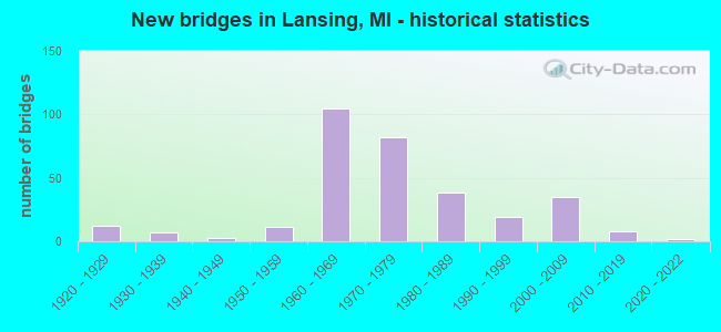
- New bridges - historical statistics
- 121920-1929
- 71930-1939
- 31940-1949
- 111950-1959
- 1051960-1969
- 821970-1979
- 381980-1989
- 191990-1999
- 352000-2009
- 82010-2019
- 22020-2022
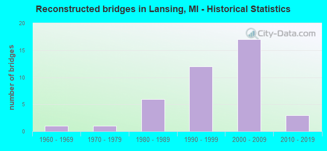
- Reconstructed bridges - Historical Statistics
- 11960-1969
- 11970-1979
- 61980-1989
- 121990-1999
- 172000-2009
- 32010-2019
- Bridge Condition - Deck
- 1.0%Excellent
- 5.6%Very good
- 26.4%Good
- 47.2%Satisfactory
- 14.7%Fair
- 4.1%Poor
- 1.0%Serious
- 0.5%Critical
- Bridge Condition - Superstructure
- 1.0%Excellent
- 7.1%Very good
- 15.7%Good
- 38.1%Satisfactory
- 31.0%Fair
- 4.1%Poor
- 2.5%Serious
- 0.5%Critical
- Bridge Condition - Substructure
- 1.0%Excellent
- 6.6%Very good
- 25.9%Good
- 47.2%Satisfactory
- 14.7%Fair
- 4.6%Poor
- Bridge Condition - Channel
- 0.8%Excellent
- 7.4%Very good
- 31.4%Good
- 46.3%Satisfactory
- 11.6%Fair
- 2.5%Poor
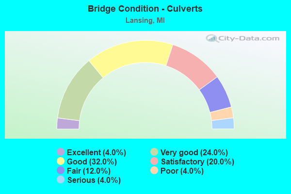
- Bridge Condition - Culverts
- 4.0%Excellent
- 24.0%Very good
- 32.0%Good
- 20.0%Satisfactory
- 12.0%Fair
- 4.0%Poor
- 4.0%Serious
Find on map >> Show street view
Structure Number: 3936, Location: IN THE CITY OF LANSING (Lat: 42.721892, Lng: -84.548861), Route carried "on" structure: City street , Year Built: 1980, Status: Posted for load, Structure Length: 3.92m (12.86ft), Average Daily Traffic: 2,000 (year 2011), Truck Traffic: 10%, Average Future Daily Traffic: 2,300 (year 2031), Design Load: HS 20+Mod, Features Intersected: RED CEDAR RIVER, Facility Carried by Structure: E ELM STREET
Minimum Vertical Clearance: 30.48m (100.00ft), Kilometerpoint: 0.541, Lanes on structure: 2, Owner: City or Municipal Highway Agency, Approaching Roadway Width: 9.1m (29.9ft), Material/Design: Prestressed concrete, Design/Construction: Box Beam or Girders - Multiple, Number Of Spans In Main Unit: 2, Length of Maximum Span: 19.6m (64.3ft), Curb or Sidewalk Widths: Left: 1.5m (4.9ft), Right: 1.5m (4.9ft), Curb-To-Curb Width: 9.1m (29.9ft), Out-to-Out Width: 12.9m (42.3ft)
Condition: Deck: Fair, Superstructure: Serious, Substructure: Fair, Channel: Satisfactory, Operating Rating: 16.5 metric tons, Method Used To Determine Operating Rating: Load Factor (LF) rating reported by rating factor (RF) method using MS18 loading, Inventory Rating: 2.3 metric tons, Method Used To Determine Inventory Rating: Load Factor (LF) rating reported by rating factor (RF) method using MS18 loading, Structural Evaluation: High priority of corrective action, Deck Geometry: Somewhat better than minimum adequacy, Waterway Adequacy: Equal to present desirable criteria, Approach Roadway Alignment: Equal to present desirable criteria, Bridge Posting: Required (Relationship of Operating Rating to Maximum Legal Load: > 39.9% below), Designated Inspection Frequency: Every 12 months, Underwater Inspection Frequency: Every 60 months, Inspection Date: October 2021, Underwater Inspection Date: October 2018, Deck Structure Type: Concrete Precast Panels, Wearing Surface/Protective System: Wearing Surface: Bituminous, Membrane: Preformed Fabric
Find on map >> Show street view
Structure Number: 3937, Location: IN THE CITY OF LANSING (Lat: 42.729992, Lng: -84.547139), Route carried "on" structure: City street 2003, Year Built: 1979, Status: Open, Structure Length: 12.74m (41.80ft), Average Daily Traffic: 7,875 (year 2006), Truck Traffic: 10%, Average Future Daily Traffic: 14,223 (year 2026), Design Load: HS 20+Mod, Features Intersected: GRAND RIVER, Facility Carried by Structure: KALAMAZOO STREET
Minimum Vertical Clearance: 30.48m (100.00ft), Kilometerpoint: 2.676, Lanes on structure: 4, Owner: City or Municipal Highway Agency, Approaching Roadway Width: 15.8m (51.8ft), Skew: 3 degrees, Material/Design: Steel continuous, Design/Construction: Stringer/Multi-beam, Number Of Spans In Main Unit: 3, Length of Maximum Span: 48.1m (157.8ft), Curb or Sidewalk Widths: Left: 2.4m (7.9ft), Right: 2.4m (7.9ft), Curb-To-Curb Width: 15.8m (51.8ft), Out-to-Out Width: 21.4m (70.2ft)
Condition: Deck: Satisfactory, Superstructure: Satisfactory, Substructure: Satisfactory, Channel: Satisfactory, Operating Rating: 80.0 metric tons, Method Used To Determine Operating Rating: Load Factor (LF) rating reported by rating factor (RF) method using MS18 loading, Inventory Rating: 48.0 metric tons, Method Used To Determine Inventory Rating: Load Factor (LF) rating reported by rating factor (RF) method using MS18 loading, Structural Evaluation: Equal to present minimum criteria, Deck Geometry: Meets minimum limits, Waterway Adequacy: Equal to present desirable criteria, Approach Roadway Alignment: Better than present minimum criteria, Designated Inspection Frequency: Every 24 months, Underwater Inspection Frequency: Every 60 months, Inspection Date: October 2021, Underwater Inspection Date: October 2018, Deck Structure Type: Concrete Cast-file-Place, Wearing Surface/Protective System: Wearing Surface: Latex Concrete
Find on map >> Show street view
Structure Number: 3939, Location: IN THE CITY OF LANSING (Lat: 42.737286, Lng: -84.548653), Route carried "on" structure: City street 2003, Year Built: 1996, Status: Open, Structure Length: 11.70m (38.39ft), Average Daily Traffic: 5,675 (year 2010), Truck Traffic: 10%, Average Future Daily Traffic: 10,249 (year 2030), Design Load: HS 20, Features Intersected: GRAND RIVER, Facility Carried by Structure: SHIAWASSEE STREET
Minimum Vertical Clearance: 30.48m (100.00ft), Kilometerpoint: 1.973, Lanes on structure: 4, Owner: City or Municipal Highway Agency, Approaching Roadway Width: 14.6m (47.9ft), Material/Design: Prestressed concrete, Design/Construction: Stringer/Multi-beam, Number Of Spans In Main Unit: 3, Length of Maximum Span: 39.0m (128.0ft), Curb or Sidewalk Widths: Left: 3.0m (9.8ft), Right: 3.0m (9.8ft), Curb-To-Curb Width: 14.6m (47.9ft), Out-to-Out Width: 22.9m (75.1ft)
Condition: Deck: Good, Superstructure: Very good, Substructure: Good, Channel: Good, Operating Rating: 97.2 metric tons, Method Used To Determine Operating Rating: Load Factor (LF) rating reported by rating factor (RF) method using MS18 loading, Inventory Rating: 46.7 metric tons, Method Used To Determine Inventory Rating: Load Factor (LF) rating reported by rating factor (RF) method using MS18 loading, Structural Evaluation: Better than present minimum criteria, Deck Geometry: High priority of replacement, Waterway Adequacy: Superior to present desirable criteria, Approach Roadway Alignment: Equal to present minimum criteria, Designated Inspection Frequency: Every 24 months, Underwater Inspection Frequency: Every 60 months, Inspection Date: October 2021, Underwater Inspection Date: October 2018, Deck Structure Type: Concrete Cast-file-Place, Wearing Surface/Protective System: Wearing Surface: Monolithic Concrete, Deck Protection: Epoxy Coated Reinforcing
Find on map >> Show street view
Structure Number: 394, Location: IN THE CITY OF LANSING (Lat: 42.747450, Lng: -84.550314), Route carried "on" structure: City street 2003, Year Built: 1929, Year Reconstructed: 2006, Status: Open, Structure Length: 5.48m (17.98ft), Average Daily Traffic: 5,825 (year 2006), Truck Traffic: 10%, Average Future Daily Traffic: 10,520 (year 2026), Design Load: HS 20+Mod, Features Intersected: GRAND RIVER, Facility Carried by Structure: CESAR CHAVEZ AVE
Minimum Vertical Clearance: 30.48m (100.00ft), Kilometerpoint: 0.782, Lanes on structure: 4, Owner: City or Municipal Highway Agency, Approaching Roadway Width: 15.9m (52.2ft), Material/Design: Prestressed concrete, Design/Construction: Stringer/Multi-beam, Number Of Spans In Main Unit: 3, Length of Maximum Span: 18.2m (59.7ft), Curb or Sidewalk Widths: Left: 4.2m (13.8ft), Right: 4.2m (13.8ft), Curb-To-Curb Width: 15.9m (52.2ft), Out-to-Out Width: 25.3m (83.0ft)
Condition: Deck: Good, Superstructure: Very good, Substructure: Good, Channel: Good, Operating Rating: 68.7 metric tons, Method Used To Determine Operating Rating: Load Factor (LF) rating reported by rating factor (RF) method using MS18 loading, Inventory Rating: 30.8 metric tons, Method Used To Determine Inventory Rating: Load Factor (LF) rating reported by rating factor (RF) method using MS18 loading, Structural Evaluation: Better than present minimum criteria, Deck Geometry: Meets minimum limits, Waterway Adequacy: Equal to present desirable criteria, Approach Roadway Alignment: Equal to present desirable criteria, Designated Inspection Frequency: Every 24 months, Inspection Date: October 2021, Deck Structure Type: Concrete Cast-file-Place, Wearing Surface/Protective System: Wearing Surface: Integral Concrete, Deck Protection: Epoxy Coated Reinforcing
Find on map >> Show street view
Structure Number: 3944, Location: IN THE CITY OF LANSING (Lat: 42.756028, Lng: -84.567564), Route carried "on" structure: City street 2003, Year Built: 1960, Year Reconstructed: 2001, Status: Open, Structure Length: 13.47m (44.19ft), Average Daily Traffic: 9,625 (year 2006), Truck Traffic: 15%, Average Future Daily Traffic: 17,383 (year 2026), Design Load: HS 20, Features Intersected: GRAND RIVER, Facility Carried by Structure: N MARTINLUTHERKING
Minimum Vertical Clearance: 30.48m (100.00ft), Kilometerpoint: 12.487, Lanes on structure: 4, Base Highway Network: Yes (Inventory Route: 35, Subroute: 3), Owner: City or Municipal Highway Agency, Approaching Roadway Width: 21.9m (71.9ft), Skew: 2 degrees, Material/Design: Steel, Design/Construction: Stringer/Multi-beam, Number Of Spans In Main Unit: 7, Length of Maximum Span: 21.0m (68.9ft), Curb or Sidewalk Widths: Left: 1.7m (5.6ft), Right: 1.7m (5.6ft), Curb-To-Curb Width: 15.2m (49.9ft), Out-to-Out Width: 18.4m (60.4ft)
Condition: Deck: Satisfactory, Superstructure: Satisfactory, Substructure: Good, Channel: Satisfactory, Operating Rating: 70.0 metric tons, Method Used To Determine Operating Rating: Load Factor (LF) rating reported by rating factor (RF) method using MS18 loading, Inventory Rating: 41.8 metric tons, Method Used To Determine Inventory Rating: Load Factor (LF) rating reported by rating factor (RF) method using MS18 loading, Structural Evaluation: Equal to present minimum criteria, Deck Geometry: High priority of corrective action, Waterway Adequacy: Superior to present desirable criteria, Approach Roadway Alignment: Equal to present desirable criteria, Length Of Structure Improvement: 13.46m (44.16ft), Designated Inspection Frequency: Every 24 months, Inspection Date: October 2021, Bridge Improvement Cost: $2,728,000, Roadway Improvement Cost: $21,000, Total Project Cost: $2,749,000, Deck Structure Type: Concrete Cast-file-Place, Wearing Surface/Protective System: Wearing Surface: Monolithic Concrete
Find on map >> Show street view
Structure Number: 3947, Location: IN THE CITY OF LANSING (Lat: 42.749914, Lng: -84.555275), Route carried "on" structure: City street 2003, Year Built: 1924, Year Reconstructed: 1979, Status: Open, Structure Length: 6.16m (20.21ft), Average Daily Traffic: 3,815 (year 2009), Truck Traffic: 34%, Average Future Daily Traffic: 4,578 (year 2029), Design Load: HS 20+Mod, Features Intersected: GRAND RIVER, Facility Carried by Structure: N GRAND RIVER
Minimum Vertical Clearance: 30.48m (100.00ft), Kilometerpoint: 1.751, Lanes on structure: 4, Owner: City or Municipal Highway Agency, Approaching Roadway Width: 13.7m (44.9ft), Material/Design: Concrete, Design/Construction: Arch - Deck, Number Of Spans In Main Unit: 3, Length of Maximum Span: 22.2m (72.8ft), Curb or Sidewalk Widths: Left: 1.6m (5.2ft), Right: 1.6m (5.2ft), Curb-To-Curb Width: 9.8m (32.2ft), Out-to-Out Width: 13.7m (44.9ft)
Condition: Deck: Good, Superstructure: Good, Substructure: Good, Channel: Good, Operating Rating: 78.1 metric tons, Method Used To Determine Operating Rating: Load and Resistance Factor Rating (LRFR) rating reported by rating factor(RF) method using HL-93 loadings, Inventory Rating: 60.3 metric tons, Method Used To Determine Inventory Rating: Load and Resistance Factor Rating (LRFR) rating reported by rating factor(RF) method using HL-93 loadings, Structural Evaluation: Better than present minimum criteria, Deck Geometry: High priority of replacement, Waterway Adequacy: Equal to present desirable criteria, Approach Roadway Alignment: Better than present minimum criteria, Designated Inspection Frequency: Every 24 months, Inspection Date: October 2021, Deck Structure Type: Concrete Cast-file-Place, Wearing Surface/Protective System: Wearing Surface: Bituminous
Find on map >> Show street view
Structure Number: 3948, Location: IN THE CITY OF LANSING (Lat: 42.724664, Lng: -84.552322), Route carried "on" structure: City street 2003, Year Built: 1987, Status: Open, Structure Length: 4.69m (15.39ft), Average Daily Traffic: 9,050 (year 2011), Average Future Daily Traffic: 9,997 (year 2021), Design Load: HS 20+Mod, Features Intersected: GRAND RIVER, Facility Carried by Structure: S WASHINGTON AVE
Minimum Vertical Clearance: 30.48m (100.00ft), Kilometerpoint: 3.285, Lanes on structure: 2, Owner: City or Municipal Highway Agency, Approaching Roadway Width: 18.2m (59.7ft), Skew: 20 degrees, Material/Design: Steel, Design/Construction: Stringer/Multi-beam, Number Of Spans In Main Unit: 1, Length of Maximum Span: 45.9m (150.6ft), Curb or Sidewalk Widths: Left: 2.4m (7.9ft), Right: 2.4m (7.9ft), Curb-To-Curb Width: 15.4m (50.5ft), Out-to-Out Width: 23.6m (77.4ft)
Condition: Deck: Good, Superstructure: Fair, Substructure: Satisfactory, Channel: Very good, Operating Rating: 65.1 metric tons, Method Used To Determine Operating Rating: Load Factor (LF) rating reported by rating factor (RF) method using MS18 loading, Inventory Rating: 38.9 metric tons, Method Used To Determine Inventory Rating: Load Factor (LF) rating reported by rating factor (RF) method using MS18 loading, Structural Evaluation: Somewhat better than minimum adequacy, Deck Geometry: Superior to present desirable criteria, Waterway Adequacy: Equal to present desirable criteria, Approach Roadway Alignment: Equal to present desirable criteria, Designated Inspection Frequency: Every 24 months, Inspection Date: October 2021, Deck Structure Type: Concrete Cast-file-Place, Wearing Surface/Protective System: Wearing Surface: Latex Concrete, Deck Protection: Epoxy Coated Reinforcing
Find on map >> Show street view
Structure Number: 3951, Location: IN THE CITY OF LANSING (Lat: 42.703625, Lng: -84.538150), Route carried "on" structure: City street 2003, Year Built: 2005, Status: Open, Structure Length: 6.50m (21.33ft), Average Daily Traffic: 13,400 (year 2007), Truck Traffic: 10%, Average Future Daily Traffic: 15,403 (year 2021), Design Load: HS 20+Mod, Features Intersected: NORFOLK SOUTHERN RR, Facility Carried by Structure: PENNSYLVANIA AVE
Minimum Vertical Clearance: 30.48m (100.00ft), Kilometerpoint: 4.743, Lanes on structure: 4, Owner: City or Municipal Highway Agency, Approaching Roadway Width: 15.9m (52.2ft), Skew: 7 degrees, Material/Design: Steel, Design/Construction: Stringer/Multi-beam, Number Of Spans In Main Unit: 1, Length of Maximum Span: 64.0m (210.0ft), Curb or Sidewalk Widths: Left: 1.5m (4.9ft), Right: 1.5m (4.9ft), Curb-To-Curb Width: 14.6m (47.9ft), Out-to-Out Width: 18.4m (60.4ft)
Condition: Deck: Satisfactory, Superstructure: Good, Substructure: Good, Operating Rating: 68.4 metric tons, Method Used To Determine Operating Rating: Load Factor (LF) rating reported by rating factor (RF) method using MS18 loading, Inventory Rating: 40.8 metric tons, Method Used To Determine Inventory Rating: Load Factor (LF) rating reported by rating factor (RF) method using MS18 loading, Structural Evaluation: Better than present minimum criteria, Deck Geometry: High priority of replacement, Underclear: Meets minimum limits, Approach Roadway Alignment: Equal to present desirable criteria, Designated Inspection Frequency: Every 24 months, Inspection Date: October 2021, Deck Structure Type: Concrete Cast-file-Place, Wearing Surface/Protective System: Wearing Surface: Monolithic Concrete, Deck Protection: Epoxy Coated Reinforcing
Find on map >> Show street view
Structure Number: 3952, Location: IN THE CITY OF LANSING (Lat: 42.718061, Lng: -84.538108), Route carried "on" structure: City street 2003, Year Built: 1963, Status: Open, Structure Length: 4.66m (15.29ft), Average Daily Traffic: 17,675 (year 2010), Truck Traffic: 15%, Average Future Daily Traffic: 31,923 (year 2030), Design Load: HS 20+Mod, Features Intersected: RED CEDAR RIVER, Facility Carried by Structure: PENNSYLVANIA AVE
Minimum Vertical Clearance: 30.48m (100.00ft), Kilometerpoint: 6.396, Lanes on structure: 2, Owner: City or Municipal Highway Agency, Approaching Roadway Width: 18.6m (61.0ft), Skew: 21 degrees, Material/Design: Steel, Design/Construction: Stringer/Multi-beam, Number Of Spans In Main Unit: 3, Length of Maximum Span: 16.4m (53.8ft), Curb or Sidewalk Widths: Left: 1.7m (5.6ft), Right: 1.7m (5.6ft), Curb-To-Curb Width: 8.5m (27.9ft), Out-to-Out Width: 23.2m (76.1ft)
Condition: Deck: Satisfactory, Superstructure: Satisfactory, Substructure: Satisfactory, Channel: Satisfactory, Operating Rating: 59.0 metric tons, Method Used To Determine Operating Rating: Load Factor (LF) rating reported by rating factor (RF) method using MS18 loading, Inventory Rating: 32.7 metric tons, Method Used To Determine Inventory Rating: Load Factor (LF) rating reported by rating factor (RF) method using MS18 loading, Structural Evaluation: Equal to present minimum criteria, Deck Geometry: High priority of replacement, Waterway Adequacy: Equal to present desirable criteria, Approach Roadway Alignment: Equal to present desirable criteria, Designated Inspection Frequency: Every 24 months, Underwater Inspection Frequency: Every 60 months, Inspection Date: October 2021, Underwater Inspection Date: October 2020, Deck Structure Type: Concrete Cast-file-Place, Wearing Surface/Protective System: Wearing Surface: Latex Concrete
Find on map >> Show street view
Structure Number: 3955, Location: IN THE CITY OF LANSING (Lat: 42.716633, Lng: -84.522603), Route carried "on" structure: City street 2003, Year Built: 1972, Year Reconstructed: 2009, Status: Open, Structure Length: 5.94m (19.49ft), Average Daily Traffic: 9,450 (year 2010), Average Future Daily Traffic: 10,543 (year 2021), Design Load: HS 20+Mod, Features Intersected: RED CEDAR RIVER, Facility Carried by Structure: AURELIUS ROAD
Minimum Vertical Clearance: 30.48m (100.00ft), Kilometerpoint: 27.894, Lanes on structure: 2, Owner: City or Municipal Highway Agency, Approaching Roadway Width: 21.0m (68.9ft), Skew: 2 degrees, Material/Design: Steel, Design/Construction: Stringer/Multi-beam, Number Of Spans In Main Unit: 3, Length of Maximum Span: 19.8m (65.0ft), Curb or Sidewalk Widths: Left: 4.2m (13.8ft), Right: 2.8m (9.2ft), Curb-To-Curb Width: 10.4m (34.1ft), Out-to-Out Width: 18.3m (60.0ft)
Condition: Deck: Very good, Superstructure: Good, Substructure: Good, Channel: Good, Operating Rating: 52.2 metric tons, Method Used To Determine Operating Rating: Load Factor (LF) rating reported by rating factor (RF) method using MS18 loading, Inventory Rating: 31.1 metric tons, Method Used To Determine Inventory Rating: Load Factor (LF) rating reported by rating factor (RF) method using MS18 loading, Structural Evaluation: Better than present minimum criteria, Deck Geometry: Meets minimum limits, Waterway Adequacy: Superior to present desirable criteria, Approach Roadway Alignment: Equal to present desirable criteria, Designated Inspection Frequency: Every 24 months, Underwater Inspection Frequency: Every 60 months, Inspection Date: October 2021, Underwater Inspection Date: October 2020, Deck Structure Type: Concrete Cast-file-Place, Wearing Surface/Protective System: Wearing Surface: Monolithic Concrete, Deck Protection: Epoxy Coated Reinforcing
Find on map >> Show street view
Structure Number: 3956, Location: IN THE CITY OF LANSING (Lat: 42.719383, Lng: -84.522272), Route carried "on" structure: City street 2003, Year Built: 2021, Status: Open, Structure Length: 3.19m (10.47ft), Average Daily Traffic: 8,715 (year 2019), Truck Traffic: 4%, Average Future Daily Traffic: 10,635 (year 2039), Design Load: Greater than HL93, Features Intersected: GRAND TRUNK RAILROAD, Facility Carried by Structure: AURELIUS ROAD
Minimum Vertical Clearance: 30.48m (100.00ft), Kilometerpoint: 28.189, Lanes on structure: 2, Owner: City or Municipal Highway Agency, Approaching Roadway Width: 11.0m (36.1ft), Material/Design: Prestressed concrete, Design/Construction: Stringer/Multi-beam, Number Of Spans In Main Unit: 1, Length of Maximum Span: 30.9m (101.4ft), Curb or Sidewalk Widths: Left: 3.0m (9.8ft), Right: 3.0m (9.8ft), Curb-To-Curb Width: 10.4m (34.1ft), Out-to-Out Width: 17.5m (57.4ft)
Condition: Deck: Excellent, Superstructure: Excellent, Substructure: Excellent, Operating Rating: 47.3 metric tons, Method Used To Determine Operating Rating: Load and Resistance Factor Rating (LRFR) rating reported by rating factor(RF) method using HL-93 loadings, Inventory Rating: 36.6 metric tons, Method Used To Determine Inventory Rating: Load and Resistance Factor Rating (LRFR) rating reported by rating factor(RF) method using HL-93 loadings, Structural Evaluation: Superior to present desirable criteria, Deck Geometry: Meets minimum limits, Underclear: Equal to present minimum criteria, Approach Roadway Alignment: Equal to present desirable criteria, Designated Inspection Frequency: Every 24 months, Inspection Date: November 2021, Deck Structure Type: Concrete Cast-file-Place, Wearing Surface/Protective System: Wearing Surface: Monolithic Concrete, Deck Protection: Epoxy Coated Reinforcing
Find on map >> Show street view
Structure Number: 3958, Location: IN THE CITY OF LANSING (Lat: 42.721267, Lng: -84.544403), Route carried "on" structure: City street , Year Built: 2007, Status: Open, Structure Length: 4.85m (15.91ft), Average Daily Traffic: 1,580 (year 2001), Truck Traffic: 10%, Average Future Daily Traffic: 2,870 (year 2027), Design Load: HS 25 or greater, Features Intersected: RED CEDAR RIVER, Facility Carried by Structure: BEECH STREET
Minimum Vertical Clearance: 30.48m (100.00ft), Kilometerpoint: 0.151, Lanes on structure: 2, Owner: City or Municipal Highway Agency, Approaching Roadway Width: 7.0m (23.0ft), Material/Design: Prestressed concrete, Design/Construction: Box Beam or Girders - Multiple, Number Of Spans In Main Unit: 3, Length of Maximum Span: 18.9m (62.0ft), Curb or Sidewalk Widths: Left: 0.0m, Right: 2.0m (6.6ft), Curb-To-Curb Width: 8.6m (28.2ft), Out-to-Out Width: 11.5m (37.7ft)
Condition: Deck: Good, Superstructure: Fair, Substructure: Good, Channel: Very good, Operating Rating: 54.8 metric tons, Method Used To Determine Operating Rating: Load and Resistance Factor Rating (LRFR) rating reported by rating factor(RF) method using HL-93 loadings, Inventory Rating: 38.9 metric tons, Method Used To Determine Inventory Rating: Load and Resistance Factor Rating (LRFR) rating reported by rating factor(RF) method using HL-93 loadings, Structural Evaluation: Somewhat better than minimum adequacy, Deck Geometry: Somewhat better than minimum adequacy, Waterway Adequacy: Equal to present desirable criteria, Approach Roadway Alignment: Equal to present desirable criteria, Designated Inspection Frequency: Every 24 months, Inspection Date: October 2021, Deck Structure Type: Concrete Cast-file-Place, Wearing Surface/Protective System: Wearing Surface: Integral Concrete, Deck Protection: Epoxy Coated Reinforcing
Find on map >> Show street view
Structure Number: 4111, Location: 2.8 MI N OF ARENAC COL (Lat: 44.201556, Lng: -83.803294), Route carried "on" structure: State highway 65, Year Built: 1950, Status: Open, Structure Length: 3.66m (12.01ft), Average Daily Traffic: 4,353 (year 2018), Truck Traffic: 4%, Average Future Daily Traffic: 5,006 (year 2038), Design Load: HS 20, Features Intersected: JOHNSON CREEK
Minimum Vertical Clearance: 30.48m (100.00ft), Kilometerpoint: 4.434, Lanes on structure: 2, Base Highway Network: Yes (Inventory Route: 335, Subroute: 38), Owner: State Highway Agency, Approaching Roadway Width: 12.8m (42.0ft), Material/Design: Steel, Design/Construction: Stringer/Multi-beam, Number Of Spans In Main Unit: 3, Length of Maximum Span: 12.2m (40.0ft), Curb or Sidewalk Widths: Left: 0.4m (1.3ft), Right: 0.4m (1.3ft), Curb-To-Curb Width: 8.5m (27.9ft), Out-to-Out Width: 10.1m (33.1ft)
Condition: Deck: Poor, Superstructure: Satisfactory, Substructure: Satisfactory, Channel: Poor, Operating Rating: 64.2 metric tons, Method Used To Determine Operating Rating: Load Factor (LF) rating reported by rating factor (RF) method using MS18 loading, Inventory Rating: 38.6 metric tons, Method Used To Determine Inventory Rating: Load Factor (LF) rating reported by rating factor (RF) method using MS18 loading, Structural Evaluation: Equal to present minimum criteria, Deck Geometry: Meets minimum limits, Waterway Adequacy: Better than present minimum criteria, Approach Roadway Alignment: Equal to present desirable criteria, Designated Inspection Frequency: Every 12 months, Inspection Date: July 2021, Deck Structure Type: Concrete Cast-file-Place, Wearing Surface/Protective System: Wearing Surface: Bituminous
Find on map >> Show street view
Structure Number: 4115, Location: 6.0 MI N OF M-55 (Lat: 44.360825, Lng: -83.804381), Route carried "on" structure: State highway 65, Year Built: 1952, Status: Open, Structure Length: 1.37m (4.49ft), Average Daily Traffic: 6,737 (year 2003), Truck Traffic: 5%, Average Future Daily Traffic: 7,849 (year 2018), Design Load: HS 20, Features Intersected: BR HALE CREEK
Minimum Vertical Clearance: 30.48m (100.00ft), Kilometerpoint: 22.132, Lanes on structure: 2, Base Highway Network: Yes (Inventory Route: 335, Subroute: 38), Owner: State Highway Agency, Approaching Roadway Width: 12.8m (42.0ft), Skew: 4 degrees, Material/Design: Steel, Design/Construction: Stringer/Multi-beam, Number Of Spans In Main Unit: 1, Length of Maximum Span: 13.7m (44.9ft), Curb or Sidewalk Widths: Left: 0.4m (1.3ft), Right: 0.4m (1.3ft), Curb-To-Curb Width: 11.6m (38.1ft), Out-to-Out Width: 13.2m (43.3ft)
Condition: Deck: Satisfactory, Superstructure: Fair, Substructure: Good, Channel: Satisfactory, Operating Rating: 55.4 metric tons, Method Used To Determine Operating Rating: Load Factor (LF) rating reported by rating factor (RF) method using MS18 loading, Inventory Rating: 33.4 metric tons, Method Used To Determine Inventory Rating: Load Factor (LF) rating reported by rating factor (RF) method using MS18 loading, Structural Evaluation: Somewhat better than minimum adequacy, Deck Geometry: Somewhat better than minimum adequacy, Waterway Adequacy: Equal to present desirable criteria, Approach Roadway Alignment: Better than present minimum criteria, Designated Inspection Frequency: Every 24 months, Inspection Date: July 2021, Deck Structure Type: Concrete Cast-file-Place, Wearing Surface/Protective System: Wearing Surface: Bituminous
Find on map >> Show street view
Structure Number: 4119, Location: 0.8 MI E OF OGEMAW COL (Lat: 44.277036, Lng: -83.866000), Route carried "on" structure: State highway 55, Year Built: 1929, Year Reconstructed: 1993, Status: Open, Structure Length: 1.06m (3.48ft), Average Daily Traffic: 2,529 (year 2007), Truck Traffic: 15%, Average Future Daily Traffic: 3,686 (year 2018), Design Load: HS 25 or greater, Features Intersected: AU GRES RIVER
Minimum Vertical Clearance: 30.48m (100.00ft), Kilometerpoint: 1.392, Lanes on structure: 2, Base Highway Network: Yes (Inventory Route: 125, Subroute: 7), Owner: State Highway Agency, Approaching Roadway Width: 11.0m (36.1ft), Material/Design: Prestressed concrete, Design/Construction: Stringer/Multi-beam, Number Of Spans In Main Unit: 1, Length of Maximum Span: 10.6m (34.8ft), Curb-To-Curb Width: 11.0m (36.1ft), Out-to-Out Width: 11.9m (39.0ft)
Condition: Deck: Good, Superstructure: Very good, Substructure: Good, Channel: Satisfactory, Operating Rating: 73.2 metric tons, Method Used To Determine Operating Rating: Load Factor (LF) rating reported by rating factor (RF) method using MS18 loading, Inventory Rating: 44.1 metric tons, Method Used To Determine Inventory Rating: Load Factor (LF) rating reported by rating factor (RF) method using MS18 loading, Structural Evaluation: Better than present minimum criteria, Deck Geometry: Somewhat better than minimum adequacy, Waterway Adequacy: Somewhat better than minimum adequacy, Approach Roadway Alignment: Equal to present minimum criteria, Designated Inspection Frequency: Every 24 months, Inspection Date: July 2021, Deck Structure Type: Concrete Cast-file-Place, Wearing Surface/Protective System: Wearing Surface: Epoxy Overlay, Deck Protection: Epoxy Coated Reinforcing
Find on map >> Show street view
Structure Number: 6642, Location: 4.9 MI S OF MANISTEE COL (Lat: 44.120481, Lng: -86.279978), Route carried "on" structure: US 31, Year Built: 1959, Status: Open, Structure Length: 1.82m (5.97ft), Average Daily Traffic: 6,578 (year 2007), Truck Traffic: 8%, Average Future Daily Traffic: 9,001 (year 2018), Design Load: HS 20, Features Intersected: BIG SABLE RIVER
Minimum Vertical Clearance: 30.48m (100.00ft), Kilometerpoint: 18.793, Lanes on structure: 2, Base Highway Network: Yes (Inventory Route: 21, Subroute: 7), Owner: State Highway Agency, Approaching Roadway Width: 12.2m (40.0ft), Material/Design: Prestressed concrete, Design/Construction: Box Beam or Girders - Multiple, Number Of Spans In Main Unit: 1, Length of Maximum Span: 18.2m (59.7ft), Curb-To-Curb Width: 13.4m (44.0ft), Out-to-Out Width: 14.3m (46.9ft)
Condition: Deck: Fair, Superstructure: Fair, Substructure: Satisfactory, Channel: Good, Operating Rating: 60.3 metric tons, Method Used To Determine Operating Rating: Load Factor (LF) rating reported by rating factor (RF) method using MS18 loading, Inventory Rating: 29.5 metric tons, Method Used To Determine Inventory Rating: Load Factor (LF) rating reported by rating factor (RF) method using MS18 loading, Structural Evaluation: Somewhat better than minimum adequacy, Deck Geometry: Equal to present minimum criteria, Waterway Adequacy: Equal to present desirable criteria, Approach Roadway Alignment: Somewhat better than minimum adequacy, Designated Inspection Frequency: Every 24 months, Inspection Date: May 2020, Deck Structure Type: Concrete Cast-file-Place, Wearing Surface/Protective System: Wearing Surface: Latex Concrete, Deck Protection: Epoxy Coated Reinforcing
Find on map >> Show street view
Structure Number: 6687, Location: 4 MI W 4.5 M N SCOTTVILLE (Lat: 44.020225, Lng: -86.360619), Route carried "on" structure: County highway , Year Built: 2000, Status: Open, Structure Length: 1.79m (5.87ft), Average Daily Traffic: 300 (year 1997), Truck Traffic: 5%, Average Future Daily Traffic: 350 (year 2017), Design Load: HS 20, Features Intersected: N BR LINCOLN RIVER, Facility Carried by Structure: VICTORY CORNER RD
Minimum Vertical Clearance: 30.48m (100.00ft), Kilometerpoint: 4.728, Lanes on structure: 2, Owner: County Highway Agency, Approaching Roadway Width: 7.3m (24.0ft), Skew: 1 degrees, Material/Design: Prestressed concrete, Design/Construction: Box Beam or Girders - Multiple, Number Of Spans In Main Unit: 1, Length of Maximum Span: 17.9m (58.7ft), Curb-To-Curb Width: 9.4m (30.8ft), Out-to-Out Width: 9.5m (31.2ft)
Condition: Deck: Good, Superstructure: Good, Substructure: Very good, Channel: Satisfactory, Operating Rating: 56.4 metric tons, Method Used To Determine Operating Rating: Load Factor (LF) rating reported by rating factor (RF) method using MS18 loading, Inventory Rating: 33.7 metric tons, Method Used To Determine Inventory Rating: Load Factor (LF) rating reported by rating factor (RF) method using MS18 loading, Structural Evaluation: Better than present minimum criteria, Waterway Adequacy: Better than present minimum criteria, Approach Roadway Alignment: Better than present minimum criteria, Designated Inspection Frequency: Every 24 months, Inspection Date: August 2020, Deck Structure Type: Concrete Precast Panels, Wearing Surface/Protective System: Wearing Surface: Bituminous
Find on map >> Show street view
Structure Number: 6688, Location: 2 MI W 4 MI N SCOTTVILLE (Lat: 44.015058, Lng: -86.320017), Route carried "on" structure: County highway , Year Built: 1978, Status: Open, Structure Length: 0.82m (2.69ft), Average Daily Traffic: 120 (year 1997), Truck Traffic: 5%, Average Future Daily Traffic: 150 (year 2017), Design Load: HS 20+Mod, Features Intersected: S BR LINCOLN RIVER, Facility Carried by Structure: AMBER ROAD
Minimum Vertical Clearance: 30.48m (100.00ft), Kilometerpoint: 3.277, Lanes on structure: 2, Owner: County Highway Agency, Approaching Roadway Width: 8.5m (27.9ft), Material/Design: Steel, Design/Construction: Culvert, Number Of Spans In Main Unit: 2, Length of Maximum Span: 3.6m (11.8ft), Curb-To-Curb Width: 6.1m (20.0ft), Out-to-Out Width: 6.1m (20.0ft)
Condition: Channel: Satisfactory, Culverts: Good, Operating Rating: 83.6 metric tons, Method Used To Determine Operating Rating: Load Factor (LF) rating reported by rating factor (RF) method using MS18 loading, Inventory Rating: 83.3 metric tons, Method Used To Determine Inventory Rating: Load Factor (LF) rating reported by rating factor (RF) method using MS18 loading, Structural Evaluation: Better than present minimum criteria, Deck Geometry: Meets minimum limits, Waterway Adequacy: Meets minimum limits, Approach Roadway Alignment: Equal to present minimum criteria, Designated Inspection Frequency: Every 24 months, Inspection Date: August 2020, Wearing Surface/Protective System: Wearing Surface: Gravel
Find on map >> Show street view
Structure Number: 6742, Location: 2 MI NW OF BIG RAPIDS (Lat: 43.742764, Lng: -85.530500), Route carried "on" structure: Business US 131, Year Built: 1982, Status: Open, Structure Length: 4.26m (13.98ft), Average Daily Traffic: 4,635 (year 2007), Truck Traffic: 9%, Average Future Daily Traffic: 6,351 (year 2018), Design Load: HS 20, Features Intersected: US-131 NB
Minimum Vertical Clearance: 30.48m (100.00ft), Kilometerpoint: 2.588, Lanes on structure: 2, Lanes under structure: 4, Owner: State Highway Agency, Approaching Roadway Width: 15.2m (49.9ft), Skew: 2 degrees, Material/Design: Steel, Design/Construction: Stringer/Multi-beam, Number Of Spans In Main Unit: 1, Length of Maximum Span: 42.6m (139.8ft), Curb-To-Curb Width: 14.6m (47.9ft), Out-to-Out Width: 15.8m (51.8ft)
Condition: Deck: Good, Superstructure: Satisfactory, Substructure: Good, Operating Rating: 89.4 metric tons, Method Used To Determine Operating Rating: Load Factor (LF) rating reported by rating factor (RF) method using MS18 loading, Inventory Rating: 53.5 metric tons, Method Used To Determine Inventory Rating: Load Factor (LF) rating reported by rating factor (RF) method using MS18 loading, Structural Evaluation: Equal to present minimum criteria, Deck Geometry: Superior to present desirable criteria, Underclear: Better than present minimum criteria, Approach Roadway Alignment: Equal to present desirable criteria, Designated Inspection Frequency: Every 24 months, Inspection Date: June 2021, Deck Structure Type: Concrete Cast-file-Place, Wearing Surface/Protective System: Wearing Surface: Epoxy Overlay, Deck Protection: Epoxy Coated Reinforcing
Find on map >> Show street view
Structure Number: 6853, Location: 1.5 MI. N OF HOULE (Lat: 45.724572, Lng: -87.396931), Route carried "on" structure: County highway , Year Built: 1973, Status: Open, Structure Length: 0.61m (2.00ft), Average Daily Traffic: 20 (year 2005), Average Future Daily Traffic: 25 (year 2019), Design Load: HS 20+Mod, Features Intersected: FORTY SEVEN MILE CREEK, Facility Carried by Structure: D-3 ROAD
Minimum Vertical Clearance: 30.48m (100.00ft), Kilometerpoint: 2.107, Lanes on structure: 2, Owner: County Highway Agency, Approaching Roadway Width: 7.9m (25.9ft), Material/Design: Steel, Design/Construction: Culvert, Number Of Spans In Main Unit: 2, Length of Maximum Span: 2.7m (8.9ft)
Condition: Channel: Satisfactory, Culverts: Fair, Operating Rating: 32.4 metric tons, Method Used To Determine Operating Rating: Load Factor (LF), Inventory Rating: 19.4 metric tons, Method Used To Determine Inventory Rating: Load Factor (LF), Structural Evaluation: Somewhat better than minimum adequacy, Waterway Adequacy: Meets minimum limits, Approach Roadway Alignment: Equal to present desirable criteria, Designated Inspection Frequency: Every 24 months, Inspection Date: June 2021
Find on map >> Show street view
Structure Number: 7187, Location: 1.6 MI N OF STATE LINE (Lat: 41.768203, Lng: -83.480697), Route carried "on" structure: Ramp Interstate 75, Year Built: 1976, Status: Open, Structure Length: 12.68m (41.60ft), Average Daily Traffic: 1,456 (year 2007), Truck Traffic: 27%, Average Future Daily Traffic: 6,240 (year 2020), Design Load: HS 25 or greater, Features Intersected: I-75
Minimum Vertical Clearance: 30.48m (100.00ft), Kilometerpoint: 0.608, Lanes on structure: 1, Lanes under structure: 6, Owner: State Highway Agency, Approaching Roadway Width: 7.6m (24.9ft), Skew: 4 degrees, Material/Design: Steel, Design/Construction: Stringer/Multi-beam, Number Of Spans In Main Unit: 4, Length of Maximum Span: 46.3m (151.9ft), Curb-To-Curb Width: 7.2m (23.6ft), Out-to-Out Width: 8.2m (26.9ft)
Condition: Deck: Fair, Superstructure: Fair, Substructure: Fair, Operating Rating: 77.4 metric tons, Method Used To Determine Operating Rating: Load Factor (LF) rating reported by rating factor (RF) method using MS18 loading, Inventory Rating: 46.3 metric tons, Method Used To Determine Inventory Rating: Load Factor (LF) rating reported by rating factor (RF) method using MS18 loading, Structural Evaluation: Somewhat better than minimum adequacy, Deck Geometry: Equal to present minimum criteria, Underclear: Somewhat better than minimum adequacy, Approach Roadway Alignment: Equal to present minimum criteria, Designated Inspection Frequency: Every 18 months, Inspection Date: December 2021, Deck Structure Type: Concrete Cast-file-Place, Wearing Surface/Protective System: Wearing Surface: Latex Concrete, Deck Protection: Epoxy Coated Reinforcing
Find on map >> Show street view
Structure Number: 7268, Location: 4.25 MI N OF IDA WEST RD (Lat: 41.964611, Lng: -83.546264), Route carried "on" structure: County highway 5833, Year Built: 1958, Year Reconstructed: 2004, Status: Open, Structure Length: 0.91m (2.99ft), Average Daily Traffic: 2,666 (year 2017), Truck Traffic: 12%, Average Future Daily Traffic: 3,066 (year 2037), Design Load: HS 20+Mod, Features Intersected: MILL RACE, Facility Carried by Structure: IDA MAYBEE RD
Minimum Vertical Clearance: 30.48m (100.00ft), Kilometerpoint: 0.674, Lanes on structure: 2, Owner: County Highway Agency, Approaching Roadway Width: 7.9m (25.9ft), Material/Design: Prestressed concrete, Design/Construction: Box Beam or Girders - Single/Spread, Number Of Spans In Main Unit: 1, Length of Maximum Span: 8.4m (27.6ft), Curb-To-Curb Width: 9.8m (32.2ft), Out-to-Out Width: 10.5m (34.4ft)
Condition: Deck: Good, Superstructure: Very good, Substructure: Satisfactory, Channel: Very good, Operating Rating: 65.1 metric tons, Method Used To Determine Operating Rating: Load Factor (LF) rating reported by rating factor (RF) method using MS18 loading, Inventory Rating: 39.2 metric tons, Method Used To Determine Inventory Rating: Load Factor (LF) rating reported by rating factor (RF) method using MS18 loading, Structural Evaluation: Equal to present minimum criteria, Deck Geometry: Meets minimum limits, Waterway Adequacy: Equal to present desirable criteria, Approach Roadway Alignment: Equal to present minimum criteria, Designated Inspection Frequency: Every 24 months, Inspection Date: November 2021, Deck Structure Type: Concrete Cast-file-Place, Wearing Surface/Protective System: Wearing Surface: Monolithic Concrete, Deck Protection: Epoxy Coated Reinforcing
Find on map >> Show street view
Structure Number: 7269, Location: .15 MI E OF IDA MAYBEE RD (Lat: 42.006597, Lng: -83.531342), Route carried "on" structure: County highway 5837, Year Built: 1979, Status: Open, Structure Length: 1.04m (3.41ft), Average Daily Traffic: 1,038 (year 2000), Truck Traffic: 11%, Average Future Daily Traffic: 1,245 (year 2020), Design Load: HS 20, Features Intersected: SANDY CREEK, Facility Carried by Structure: STONE ROAD
Minimum Vertical Clearance: 30.48m (100.00ft), Kilometerpoint: 3.702, Lanes on structure: 2, Owner: County Highway Agency, Approaching Roadway Width: 6.7m (22.0ft), Skew: 5 degrees, Material/Design: Concrete, Design/Construction: Slab, Number Of Spans In Main Unit: 1, Length of Maximum Span: 8.5m (27.9ft), Curb-To-Curb Width: 12.2m (40.0ft), Out-to-Out Width: 12.2m (40.0ft)
Condition: Deck: Fair, Superstructure: Fair, Substructure: Satisfactory, Channel: Good, Operating Rating: 68.2 metric tons, Method Used To Determine Operating Rating: Allowable Stress (AS), Inventory Rating: 51.8 metric tons, Method Used To Determine Inventory Rating: Allowable Stress (AS), Structural Evaluation: Somewhat better than minimum adequacy, Deck Geometry: Better than present minimum criteria, Waterway Adequacy: Equal to present desirable criteria, Approach Roadway Alignment: Equal to present minimum criteria, Designated Inspection Frequency: Every 24 months, Inspection Date: November 2020, Deck Structure Type: Concrete Cast-file-Place, Wearing Surface/Protective System: Wearing Surface: Bituminous
Find on map >> Show street view
Structure Number: 7558, Location: 11.5 MI E OF US-31 (Lat: 43.235083, Lng: -85.975625), Route carried "on" structure: State highway 46, Year Built: 1958, Year Reconstructed: 1999, Status: Open, Structure Length: 1.06m (3.48ft), Average Daily Traffic: 6,182 (year 2007), Truck Traffic: 12%, Average Future Daily Traffic: 8,513 (year 2018), Design Load: HS 20, Features Intersected: BIG DRAIN
Minimum Vertical Clearance: 30.48m (100.00ft), Kilometerpoint: 22.171, Lanes on structure: 2, Base Highway Network: Yes (Inventory Route: 85, Subroute: 3), Owner: State Highway Agency, Approaching Roadway Width: 13.4m (44.0ft), Skew: 4 degrees, Material/Design: Prestressed concrete, Design/Construction: Box Beam or Girders - Multiple, Number Of Spans In Main Unit: 1, Length of Maximum Span: 10.6m (34.8ft), Curb or Sidewalk Widths: Left: 0.4m (1.3ft), Right: 0.4m (1.3ft), Curb-To-Curb Width: 13.4m (44.0ft), Out-to-Out Width: 15.0m (49.2ft)
Condition: Deck: Good, Superstructure: Satisfactory, Substructure: Satisfactory, Channel: Good, Operating Rating: 74.8 metric tons, Method Used To Determine Operating Rating: Load Factor (LF) rating reported by rating factor (RF) method using MS18 loading, Inventory Rating: 40.2 metric tons, Method Used To Determine Inventory Rating: Load Factor (LF) rating reported by rating factor (RF) method using MS18 loading, Structural Evaluation: Equal to present minimum criteria, Deck Geometry: Equal to present minimum criteria, Waterway Adequacy: Better than present minimum criteria, Approach Roadway Alignment: Better than present minimum criteria, Designated Inspection Frequency: Every 24 months, Inspection Date: July 2020, Deck Structure Type: Concrete Cast-file-Place, Wearing Surface/Protective System: Wearing Surface: Integral Concrete, Membrane: Other
Find on map >> Show street view
Structure Number: 7781, Location: 4.0 MI S OF FREMONT (Lat: 43.409275, Lng: -85.938336), Route carried "on" structure: County highway , Year Built: 2006, Status: Open, Structure Length: 0.91m (2.99ft), Average Daily Traffic: 199 (year 2006), Truck Traffic: 3%, Average Future Daily Traffic: 360 (year 2026), Design Load: HS 20, Features Intersected: BUTLER CREEK, Facility Carried by Structure: 80 TH STREET
Minimum Vertical Clearance: 30.48m (100.00ft), Kilometerpoint: 8.182, Lanes on structure: 2, Owner: County Highway Agency, Approaching Roadway Width: 8.5m (27.9ft), Skew: 2 degrees, Material/Design: Concrete, Design/Construction: Culvert, Number Of Spans In Main Unit: 1, Length of Maximum Span: 8.5m (27.9ft), Curb-To-Curb Width: 8.5m (27.9ft), Out-to-Out Width: 9.5m (31.2ft)
Condition: Channel: Satisfactory, Culverts: Very good, Operating Rating: 58.0 metric tons, Method Used To Determine Operating Rating: Load Factor (LF) rating reported by rating factor (RF) method using MS18 loading, Inventory Rating: 34.7 metric tons, Method Used To Determine Inventory Rating: Load Factor (LF) rating reported by rating factor (RF) method using MS18 loading, Structural Evaluation: Equal to present desirable criteria, Deck Geometry: Equal to present minimum criteria, Waterway Adequacy: Better than present minimum criteria, Approach Roadway Alignment: Better than present minimum criteria, Designated Inspection Frequency: Every 24 months, Inspection Date: June 2020, Deck Structure Type: Other, Wearing Surface/Protective System: Wearing Surface: Bituminous
Find on map >> Show street view
Structure Number: 8017, Location: 4.1 MI SE OF M-15 (Lat: 42.720778, Lng: -83.349300), Route carried "on" structure: Interstate 75, Year Built: 1962, Year Reconstructed: 1988, Status: Open, Structure Length: 4.94m (16.21ft), Average Daily Traffic: 42,870 (year 2007), Truck Traffic: 7%, Average Future Daily Traffic: 55,750 (year 2029), Design Load: HS 20, Features Intersected: CLINTONVILLE RD
Minimum Vertical Clearance: 30.48m (100.00ft), Kilometerpoint: 44.918, Lanes on structure: 3, Lanes under structure: 2, Base Highway Network: Yes (Inventory Route: 64, Subroute: 6), Owner: State Highway Agency, Approaching Roadway Width: 17.0m (55.8ft), Skew: 4 degrees, Material/Design: Steel, Design/Construction: Stringer/Multi-beam, Number Of Spans In Main Unit: 3, Length of Maximum Span: 17.8m (58.4ft), Curb-To-Curb Width: 18.0m (59.1ft), Out-to-Out Width: 18.9m (62.0ft)
Condition: Deck: Good, Superstructure: Good, Substructure: Good, Operating Rating: 56.8 metric tons, Method Used To Determine Operating Rating: Load Factor (LF), Inventory Rating: 34.0 metric tons, Method Used To Determine Inventory Rating: Load Factor (LF), Structural Evaluation: Better than present minimum criteria, Deck Geometry: Better than present minimum criteria, Underclear: High priority of corrective action, Approach Roadway Alignment: Equal to present desirable criteria, Designated Inspection Frequency: Every 24 months, Inspection Date: March 2021, Deck Structure Type: Concrete Cast-file-Place, Wearing Surface/Protective System: Wearing Surface: Epoxy Overlay, Deck Protection: Epoxy Coated Reinforcing
Find on map >> Show street view
Structure Number: 8036, Location: 5.4 MI NW OF M-15 (Lat: 42.782150, Lng: -83.534492), Route carried "on" structure: County highway 6380, Year Built: 1962, Status: Open, Structure Length: 10.39m (34.09ft), Average Daily Traffic: 6,708 (year 2010), Truck Traffic: 3%, Average Future Daily Traffic: 7,379 (year 2025), Design Load: HS 20+Mod, Features Intersected: I-75, Facility Carried by Structure: EAST HOLLY RD
Minimum Vertical Clearance: 30.48m (100.00ft), Kilometerpoint: 6.743, Lanes on structure: 2, Lanes under structure: 8, Owner: State Highway Agency, Approaching Roadway Width: 10.9m (35.8ft), Skew: 4 degrees, Material/Design: Steel, Design/Construction: Stringer/Multi-beam, Number Of Spans In Main Unit: 4, Length of Maximum Span: 35.6m (116.8ft), Curb or Sidewalk Widths: Left: 0.7m (2.3ft), Right: 0.7m (2.3ft), Curb-To-Curb Width: 9.1m (29.9ft), Out-to-Out Width: 11.2m (36.7ft)
Condition: Deck: Satisfactory, Superstructure: Good, Substructure: Fair, Operating Rating: 61.6 metric tons, Method Used To Determine Operating Rating: Load Factor (LF) rating reported by rating factor (RF) method using MS18 loading, Inventory Rating: 36.9 metric tons, Method Used To Determine Inventory Rating: Load Factor (LF) rating reported by rating factor (RF) method using MS18 loading, Structural Evaluation: Somewhat better than minimum adequacy, Deck Geometry: Meets minimum limits, Underclear: Meets minimum limits, Approach Roadway Alignment: Equal to present desirable criteria, Length Of Structure Improvement: 10.40m (34.12ft), Designated Inspection Frequency: Every 24 months, Inspection Date: December 2020, Bridge Improvement Cost: $247,000, Roadway Improvement Cost: $13,000, Total Project Cost: $149,000, Deck Structure Type: Concrete Cast-file-Place, Wearing Surface/Protective System: Wearing Surface: Latex Concrete
Find on map >> Show street view
Structure Number: 8644, Location: SECTION 6 T17N R7W (Lat: 43.900708, Lng: -85.201475), Route carried "on" structure: County highway , Year Built: 1995, Status: Open, Structure Length: 0.85m (2.79ft), Average Daily Traffic: 62 (year 2016), Truck Traffic: 13%, Average Future Daily Traffic: 120 (year 2037), Design Load: HS 20+Mod, Features Intersected: THORN CREEK, Facility Carried by Structure: 6 MILE RD
Minimum Vertical Clearance: 30+ m (98+ ft), Kilometerpoint: 4.255, Lanes on structure: 2, Owner: County Highway Agency, Approaching Roadway Width: 7.3m (24.0ft), Material/Design: Concrete, Design/Construction: Culvert, Number Of Spans In Main Unit: 2, Length of Maximum Span: 3.6m (11.8ft), Out-to-Out Width: 9.1m (29.9ft)
Condition: Channel: Very good, Culverts: Good, Operating Rating: 75.5 metric tons, Method Used To Determine Operating Rating: Load Factor (LF) rating reported by rating factor (RF) method using MS18 loading, Inventory Rating: 45.0 metric tons, Method Used To Determine Inventory Rating: Load Factor (LF) rating reported by rating factor (RF) method using MS18 loading, Structural Evaluation: Better than present minimum criteria, Waterway Adequacy: Equal to present desirable criteria, Approach Roadway Alignment: Better than present minimum criteria, Designated Inspection Frequency: Every 24 months, Inspection Date: August 2020
Find on map >> Show street view
Structure Number: 8714, Location: 3.7 MI SW OF KENT CO LINE (Lat: 42.880606, Lng: -85.843628), Route carried "on" structure: State highway 121, Year Built: 1972, Status: Open, Structure Length: 1.73m (5.68ft), Average Daily Traffic: 7,552 (year 2007), Truck Traffic: 8%, Average Future Daily Traffic: 9,582 (year 2018), Design Load: HS 20, Features Intersected: RUSH CREEK
Minimum Vertical Clearance: 30.48m (100.00ft), Kilometerpoint: 14.655, Lanes on structure: 2, Base Highway Network: Yes (Inventory Route: 370, Subroute: 73), Owner: State Highway Agency, Approaching Roadway Width: 11.0m (36.1ft), Material/Design: Steel, Design/Construction: Stringer/Multi-beam, Number Of Spans In Main Unit: 1, Length of Maximum Span: 17.3m (56.8ft), Curb or Sidewalk Widths: Left: 0.2m (0.7ft), Right: 0.2m (0.7ft), Curb-To-Curb Width: 11.9m (39.0ft), Out-to-Out Width: 12.6m (41.3ft)
Condition: Deck: Satisfactory, Superstructure: Good, Substructure: Good, Channel: Satisfactory, Operating Rating: 88.5 metric tons, Method Used To Determine Operating Rating: Load Factor (LF) rating reported by rating factor (RF) method using MS18 loading, Inventory Rating: 53.1 metric tons, Method Used To Determine Inventory Rating: Load Factor (LF) rating reported by rating factor (RF) method using MS18 loading, Structural Evaluation: Better than present minimum criteria, Deck Geometry: Better than present minimum criteria, Waterway Adequacy: Equal to present desirable criteria, Approach Roadway Alignment: Equal to present desirable criteria, Designated Inspection Frequency: Every 24 months, Inspection Date: April 2020, Deck Structure Type: Concrete Cast-file-Place, Wearing Surface/Protective System: Wearing Surface: Monolithic Concrete
Find on map >> Show street view
Structure Number: 8857, Location: SECTION 31 ALLENDALE TWP (Lat: 42.942789, Lng: -86.004997), Route carried "on" structure: County highway , Year Built: 1978, Status: Open, Structure Length: 1.15m (3.77ft), Average Daily Traffic: 3,880 (year 2020), Truck Traffic: 5%, Average Future Daily Traffic: 7,010 (year 2040), Design Load: H 20, Features Intersected: BASS CREEK, Facility Carried by Structure: FILLMORE ST
Minimum Vertical Clearance: 30.48m (100.00ft), Kilometerpoint: 16.931, Lanes on structure: 2, Owner: County Highway Agency, Approaching Roadway Width: 11.0m (36.1ft), Material/Design: Prestressed concrete, Design/Construction: Box Beam or Girders - Multiple, Number Of Spans In Main Unit: 1, Length of Maximum Span: 10.9m (35.8ft), Curb-To-Curb Width: 11.0m (36.1ft), Out-to-Out Width: 11.1m (36.4ft)
Condition: Deck: Good, Superstructure: Good, Substructure: Good, Channel: Good, Operating Rating: 51.2 metric tons, Method Used To Determine Operating Rating: Load Factor (LF) rating reported by rating factor (RF) method using MS18 loading, Inventory Rating: 30.5 metric tons, Method Used To Determine Inventory Rating: Load Factor (LF) rating reported by rating factor (RF) method using MS18 loading, Structural Evaluation: Better than present minimum criteria, Deck Geometry: Somewhat better than minimum adequacy, Waterway Adequacy: Equal to present desirable criteria, Approach Roadway Alignment: Equal to present desirable criteria, Designated Inspection Frequency: Every 24 months, Inspection Date: December 2020, Deck Structure Type: Concrete Precast Panels, Wearing Surface/Protective System: Wearing Surface: Bituminous, Membrane: Preformed Fabric
Find on map >> Show street view
Structure Number: 8859, Location: SECTION 20 BLENDON TWP (Lat: 42.899833, Lng: -85.990867), Route carried "on" structure: County highway , Year Built: 1973, Status: Open, Structure Length: 0.91m (2.99ft), Average Daily Traffic: 100 (year 2019), Truck Traffic: 5%, Average Future Daily Traffic: 180 (year 2039), Design Load: HS 20, Features Intersected: BELT DRAIN, Facility Carried by Structure: TYLER STREET
Minimum Vertical Clearance: 30.48m (100.00ft), Kilometerpoint: 2.511, Lanes on structure: 2, Owner: County Highway Agency, Approaching Roadway Width: 5.5m (18.0ft), Skew: 3 degrees, Material/Design: Prestressed concrete, Design/Construction: Box Beam or Girders - Multiple, Number Of Spans In Main Unit: 1, Length of Maximum Span: 8.5m (27.9ft), Curb-To-Curb Width: 11.0m (36.1ft), Out-to-Out Width: 11.1m (36.4ft)
Condition: Deck: Satisfactory, Superstructure: Satisfactory, Substructure: Good, Channel: Satisfactory, Operating Rating: 72.9 metric tons, Method Used To Determine Operating Rating: Load Factor (LF) rating reported by rating factor (RF) method using MS18 loading, Inventory Rating: 43.7 metric tons, Method Used To Determine Inventory Rating: Load Factor (LF) rating reported by rating factor (RF) method using MS18 loading, Structural Evaluation: Equal to present minimum criteria, Deck Geometry: Superior to present desirable criteria, Waterway Adequacy: Equal to present desirable criteria, Approach Roadway Alignment: Equal to present minimum criteria, Designated Inspection Frequency: Every 24 months, Inspection Date: November 2020, Deck Structure Type: Concrete Precast Panels, Wearing Surface/Protective System: Wearing Surface: Bituminous, Membrane: Preformed Fabric
Find on map >> Show street view
Structure Number: 8861, Location: SECTION 11 BLENDON TWP (Lat: 42.928742, Lng: -85.936497), Route carried "on" structure: County highway , Year Built: 2016, Status: Open, Structure Length: 0.66m (2.17ft), Average Daily Traffic: 100 (year 2020), Average Future Daily Traffic: 180 (year 2040), Design Load: HL 93, Features Intersected: BASS CREEK, Facility Carried by Structure: TAYLOR STREET
Minimum Vertical Clearance: 30.48m (100.00ft), Kilometerpoint: 7.019, Lanes on structure: 2, Owner: County Highway Agency, Approaching Roadway Width: 6.1m (20.0ft), Skew: 4 degrees, Material/Design: Aluminum, Iron, Design/Construction: Culvert, Number Of Spans In Main Unit: 1, Length of Maximum Span: 5.1m (16.7ft), Out-to-Out Width: 6.6m (21.7ft)
Condition: Channel: Very good, Culverts: Excellent, Operating Rating: 38.9 metric tons, Method Used To Determine Operating Rating: Load and Resistance Factor Rating (LRFR) rating reported by rating factor(RF) method using HL-93 loadings, Inventory Rating: 29.8 metric tons, Method Used To Determine Inventory Rating: Load and Resistance Factor Rating (LRFR) rating reported by rating factor(RF) method using HL-93 loadings, Structural Evaluation: Better than present minimum criteria, Waterway Adequacy: Equal to present minimum criteria, Approach Roadway Alignment: Equal to present minimum criteria, Designated Inspection Frequency: Every 24 months, Inspection Date: November 2020, Wearing Surface/Protective System: Wearing Surface: Gravel
Find on map >> Show street view
Structure Number: 8976, Location: 5.5 MI N OF ONAWAY (Lat: 45.446236, Lng: -84.216533), Route carried "on" structure: County highway 7107, Year Built: 2015, Status: Open, Structure Length: 3.26m (10.70ft), Average Daily Traffic: 1,375 (year 2014), Truck Traffic: 1%, Average Future Daily Traffic: 2,483 (year 2034), Design Load: Greater than HL93, Features Intersected: RAINY RIVER, Facility Carried by Structure: HWY 489
Minimum Vertical Clearance: 30.48m (100.00ft), Kilometerpoint: 1.754, Lanes on structure: 2, Owner: County Highway Agency, Approaching Roadway Width: 10.1m (33.1ft), Skew: 2 degrees, Material/Design: Steel, Design/Construction: Stringer/Multi-beam, Number Of Spans In Main Unit: 3, Length of Maximum Span: 19.7m (64.6ft), Curb-To-Curb Width: 10.4m (34.1ft), Out-to-Out Width: 11.4m (37.4ft)
Condition: Deck: Good, Superstructure: Very good, Substructure: Very good, Channel: Satisfactory, Operating Rating: 97.2 metric tons, Method Used To Determine Operating Rating: Load and Resistance Factor Rating (LRFR) rating reported by rating factor(RF) method using HL-93 loadings, Inventory Rating: 64.2 metric tons, Method Used To Determine Inventory Rating: Load and Resistance Factor Rating (LRFR) rating reported by rating factor(RF) method using HL-93 loadings, Structural Evaluation: Equal to present desirable criteria, Deck Geometry: Equal to present minimum criteria, Waterway Adequacy: Equal to present desirable criteria, Approach Roadway Alignment: Better than present minimum criteria, Designated Inspection Frequency: Every 24 months, Inspection Date: September 2021, Deck Structure Type: Concrete Cast-file-Place, Wearing Surface/Protective System: Wearing Surface: Monolithic Concrete, Deck Protection: Epoxy Coated Reinforcing
Find on map >> Show street view
Structure Number: 9148, Location: N JCT I-75 (Lat: 43.498453, Lng: -83.929783), Route carried "on" structure: Interstate 675, Year Built: 1971, Year Reconstructed: 2009, Status: Open, Structure Length: 10.72m (35.17ft), Average Daily Traffic: 3,061 (year 2017), Truck Traffic: 10%, Average Future Daily Traffic: 3,250 (year 2037), Design Load: HS 20, Features Intersected: I-75
Minimum Vertical Clearance: 30.48m (100.00ft), Kilometerpoint: 12.405, Lanes on structure: 2, Lanes under structure: 6, Base Highway Network: Yes (Inventory Route: 46, Subroute: 2), Owner: State Highway Agency, Approaching Roadway Width: 14.0m (45.9ft), Skew: 4 degrees, Material/Design: Steel, Design/Construction: Stringer/Multi-beam, Number Of Spans In Main Unit: 4, Length of Maximum Span: 39.5m (129.6ft), Curb-To-Curb Width: 13.2m (43.3ft), Out-to-Out Width: 13.9m (45.6ft)
Condition: Deck: Good, Superstructure: Good, Substructure: Satisfactory, Operating Rating: 99.1 metric tons, Method Used To Determine Operating Rating: Load Factor (LF), Inventory Rating: 59.3 metric tons, Method Used To Determine Inventory Rating: Load Factor (LF), Structural Evaluation: Equal to present minimum criteria, Deck Geometry: Superior to present desirable criteria, Underclear: Equal to present minimum criteria, Approach Roadway Alignment: Equal to present desirable criteria, Designated Inspection Frequency: Every 24 months, Inspection Date: November 2020, Bridge Improvement Cost: $213,000, Deck Structure Type: Concrete Cast-file-Place, Wearing Surface/Protective System: Wearing Surface: Epoxy Overlay, Deck Protection: Epoxy Coated Reinforcing
Find on map >> Show street view
Structure Number: 915, Location: 0.5 MI S OF I-75 (Lat: 43.494025, Lng: -83.936669), Route carried "on" structure: Interstate 675, Year Built: 1971, Year Reconstructed: 2009, Status: Open, Structure Length: 9.33m (30.61ft), Average Daily Traffic: 3,061 (year 2017), Truck Traffic: 10%, Average Future Daily Traffic: 3,250 (year 2037), Design Load: HS 20+Mod, Features Intersected: KOCHVILLE RD
Minimum Vertical Clearance: 30.48m (100.00ft), Kilometerpoint: 11.691, Lanes on structure: 2, Lanes under structure: 2, Base Highway Network: Yes (Inventory Route: 46, Subroute: 2), Owner: State Highway Agency, Approaching Roadway Width: 14.6m (47.9ft), Skew: 5 degrees, Material/Design: Steel continuous, Design/Construction: Stringer/Multi-beam, Number Of Spans In Main Unit: 3, Length of Maximum Span: 41.6m (136.5ft), Curb-To-Curb Width: 15.4m (50.5ft), Out-to-Out Width: 16.1m (52.8ft)
Condition: Deck: Good, Superstructure: Satisfactory, Substructure: Satisfactory, Operating Rating: 63.5 metric tons, Method Used To Determine Operating Rating: Load Factor (LF) rating reported by rating factor (RF) method using MS18 loading, Inventory Rating: 37.9 metric tons, Method Used To Determine Inventory Rating: Load Factor (LF) rating reported by rating factor (RF) method using MS18 loading, Structural Evaluation: Equal to present minimum criteria, Deck Geometry: Superior to present desirable criteria, Underclear: Better than present minimum criteria, Approach Roadway Alignment: Equal to present desirable criteria, Designated Inspection Frequency: Every 2 months, Inspection Date: Febuary 2022, Deck Structure Type: Concrete Cast-file-Place, Wearing Surface/Protective System: Wearing Surface: Epoxy Overlay, Deck Protection: Epoxy Coated Reinforcing
Find on map >> Show street view
Structure Number: 9158, Location: 3.6 MI SE OF M-46 (Lat: 43.365203, Lng: -83.867514), Route carried "on" structure: County highway 2004, Year Built: 2015, Status: Open, Structure Length: 6.04m (19.82ft), Average Daily Traffic: 1,530 (year 2015), Truck Traffic: 3%, Average Future Daily Traffic: 1,800 (year 2035), Design Load: Greater than HL93, Features Intersected: I-75, Facility Carried by Structure: BAKER RD
Minimum Vertical Clearance: 30.48m (100.00ft), Kilometerpoint: 0.414, Lanes on structure: 2, Lanes under structure: 8, Owner: State Highway Agency, Approaching Roadway Width: 12.2m (40.0ft), Material/Design: Prestressed concrete, Design/Construction: Stringer/Multi-beam, Number Of Spans In Main Unit: 2, Length of Maximum Span: 29.7m (97.4ft), Curb-To-Curb Width: 12.2m (40.0ft), Out-to-Out Width: 13.2m (43.3ft)
Condition: Deck: Very good, Superstructure: Very good, Substructure: Good, Operating Rating: 68.4 metric tons, Method Used To Determine Operating Rating: Load and Resistance Factor Rating (LRFR) rating reported by rating factor(RF) method using HL-93 loadings, Inventory Rating: 40.8 metric tons, Method Used To Determine Inventory Rating: Load and Resistance Factor Rating (LRFR) rating reported by rating factor(RF) method using HL-93 loadings, Structural Evaluation: Better than present minimum criteria, Deck Geometry: Better than present minimum criteria, Underclear: Equal to present minimum criteria, Approach Roadway Alignment: Equal to present minimum criteria, Designated Inspection Frequency: Every 24 months, Inspection Date: August 2021, Deck Structure Type: Concrete Cast-file-Place, Wearing Surface/Protective System: Wearing Surface: Monolithic Concrete, Deck Protection: Epoxy Coated Reinforcing
Find on map >> Show street view
Structure Number: 9394, Location: 0.9 MI N OF DICE ROAD (Lat: 43.480897, Lng: -84.220397), Route carried "on" structure: ServiceCounty highway , Year Built: 1991, Status: Open, Structure Length: 0.91m (2.99ft), Average Daily Traffic: 103 (year 2010), Truck Traffic: 5%, Average Future Daily Traffic: 108 (year 2020), Design Load: HS 20+Mod, Features Intersected: WEEKS DRAIN, Facility Carried by Structure: FEHN ROAD
Minimum Vertical Clearance: 30.48m (100.00ft), Kilometerpoint: 3.306, Lanes on structure: 2, Owner: County Highway Agency, Approaching Roadway Width: 7.9m (25.9ft), Skew: 1 degrees, Material/Design: Concrete, Design/Construction: Culvert, Number Of Spans In Main Unit: 1, Length of Maximum Span: 8.5m (27.9ft), Curb-To-Curb Width: 8.5m (27.9ft), Out-to-Out Width: 9.1m (29.9ft)
Condition: Channel: Fair, Culverts: Satisfactory, Operating Rating: 59.9 metric tons, Method Used To Determine Operating Rating: Load Factor (LF) rating reported by rating factor (RF) method using MS18 loading, Inventory Rating: 36.0 metric tons, Method Used To Determine Inventory Rating: Load Factor (LF) rating reported by rating factor (RF) method using MS18 loading, Structural Evaluation: Equal to present minimum criteria, Deck Geometry: Equal to present minimum criteria, Waterway Adequacy: Better than present minimum criteria, Approach Roadway Alignment: Equal to present desirable criteria, Designated Inspection Frequency: Every 24 months, Inspection Date: August 2020, Deck Structure Type: Concrete Precast Panels, Wearing Surface/Protective System: Wearing Surface: Gravel, Membrane: Epoxy
Find on map >> Show street view
Structure Number: 9395, Location: 0.2 MI N OF DICE ROAD (Lat: 43.467925, Lng: -84.210522), Route carried "on" structure: ServiceCounty highway , Year Built: 2005, Status: Open, Structure Length: 1.28m (4.20ft), Average Daily Traffic: 118 (year 2010), Truck Traffic: 5%, Average Future Daily Traffic: 124 (year 2020), Design Load: HS 20+Mod, Features Intersected: WHITMORE DRAIN, Facility Carried by Structure: RAUCHOLZ ROAD
Minimum Vertical Clearance: 30.48m (100.00ft), Kilometerpoint: 8.242, Lanes on structure: 2, Owner: County Highway Agency, Approaching Roadway Width: 8.8m (28.9ft), Material/Design: Prestressed concrete, Design/Construction: Box Beam or Girders - Multiple, Number Of Spans In Main Unit: 1, Length of Maximum Span: 11.6m (38.1ft), Curb-To-Curb Width: 8.8m (28.9ft), Out-to-Out Width: 9.6m (31.5ft)
Condition: Deck: Good, Superstructure: Very good, Substructure: Very good, Channel: Satisfactory, Operating Rating: 67.7 metric tons, Method Used To Determine Operating Rating: Load Factor (LF) rating reported by rating factor (RF) method using MS18 loading, Inventory Rating: 40.5 metric tons, Method Used To Determine Inventory Rating: Load Factor (LF) rating reported by rating factor (RF) method using MS18 loading, Structural Evaluation: Equal to present desirable criteria, Deck Geometry: Equal to present minimum criteria, Waterway Adequacy: Equal to present minimum criteria, Approach Roadway Alignment: Equal to present desirable criteria, Designated Inspection Frequency: Every 24 months, Inspection Date: May 2020, Deck Structure Type: Concrete Cast-file-Place, Wearing Surface/Protective System: Wearing Surface: Integral Concrete, Deck Protection: Epoxy Coated Reinforcing