Bridge Statistics for Lansing, Michigan (MI)
Condition, Traffic, Stress, Structural Evaluation, Project Costs
- National Bridge Inventory (NBI) Statistics
- 322Number of bridges
- 3,845ft / 1,172mTotal length
- $10,930,000Total costs
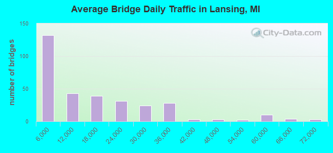
- 4,776,082Total average daily traffic
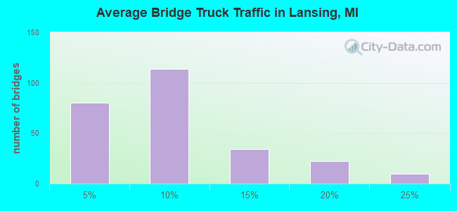
- 338,656Total average daily truck traffic
- National Bridge Inventory (NBI) Registered Bridges for Lansing
- No street view available for this location
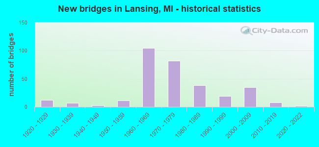
- New bridges - historical statistics
- 121920-1929
- 71930-1939
- 31940-1949
- 111950-1959
- 1051960-1969
- 821970-1979
- 381980-1989
- 191990-1999
- 352000-2009
- 82010-2019
- 22020-2022
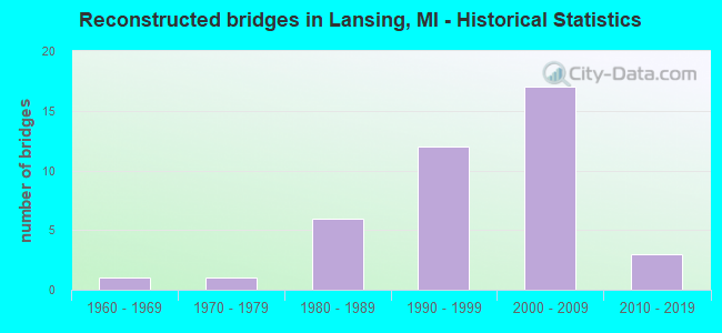
- Reconstructed bridges - Historical Statistics
- 11960-1969
- 11970-1979
- 61980-1989
- 121990-1999
- 172000-2009
- 32010-2019
- Bridge Condition - Deck
- 1.0%Excellent
- 5.6%Very good
- 26.4%Good
- 47.2%Satisfactory
- 14.7%Fair
- 4.1%Poor
- 1.0%Serious
- 0.5%Critical
- Bridge Condition - Superstructure
- 1.0%Excellent
- 7.1%Very good
- 15.7%Good
- 38.1%Satisfactory
- 31.0%Fair
- 4.1%Poor
- 2.5%Serious
- 0.5%Critical
- Bridge Condition - Substructure
- 1.0%Excellent
- 6.6%Very good
- 25.9%Good
- 47.2%Satisfactory
- 14.7%Fair
- 4.6%Poor
- Bridge Condition - Channel
- 0.8%Excellent
- 7.4%Very good
- 31.4%Good
- 46.3%Satisfactory
- 11.6%Fair
- 2.5%Poor
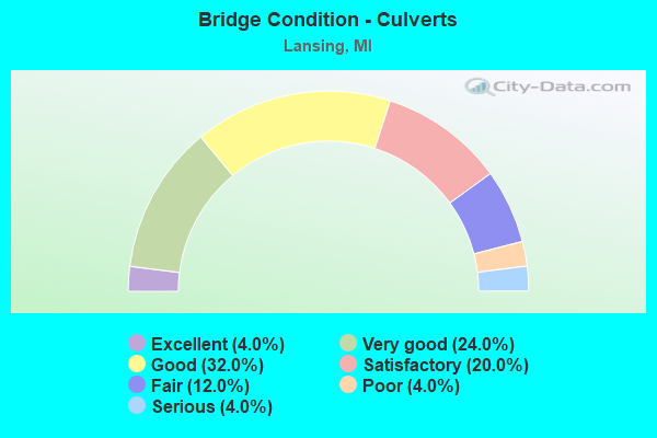
- Bridge Condition - Culverts
- 4.0%Excellent
- 24.0%Very good
- 32.0%Good
- 20.0%Satisfactory
- 12.0%Fair
- 4.0%Poor
- 4.0%Serious
Find on map >> Show street view
Structure Number: 2797, Location: BET VIENNA & FARRAND ROAD (Lat: 43.187206, Lng: -83.863669), Route carried "on" structure: County highway , Year Built: 1929, Status: Open, Structure Length: 1.06m (3.48ft), Average Daily Traffic: 701 (year 2018), Truck Traffic: 2%, Average Future Daily Traffic: 1,266 (year 2038), Design Load: HS 20+Mod, Features Intersected: BRENT RUN, Facility Carried by Structure: MCKINLEY ROAD
Minimum Vertical Clearance: 30.48m (100.00ft), Kilometerpoint: 14.332, Lanes on structure: 2, Owner: County Highway Agency, Approaching Roadway Width: 11.0m (36.1ft), Material/Design: Steel, Design/Construction: Stringer/Multi-beam, Number Of Spans In Main Unit: 1, Length of Maximum Span: 10.0m (32.8ft), Curb-To-Curb Width: 9.1m (29.9ft), Out-to-Out Width: 10.1m (33.1ft)
Condition: Deck: Satisfactory, Superstructure: Serious, Substructure: Satisfactory, Channel: Good, Operating Rating: 57.3 metric tons, Method Used To Determine Operating Rating: Load Factor (LF) rating reported by rating factor (RF) method using MS18 loading, Inventory Rating: 34.3 metric tons, Method Used To Determine Inventory Rating: Load Factor (LF) rating reported by rating factor (RF) method using MS18 loading, Structural Evaluation: High priority of corrective action, Deck Geometry: Equal to present minimum criteria, Waterway Adequacy: Equal to present desirable criteria, Approach Roadway Alignment: Equal to present minimum criteria, Designated Inspection Frequency: Every 12 months, Inspection Date: May 2021, Deck Structure Type: Concrete Cast-file-Place, Wearing Surface/Protective System: Wearing Surface: Bituminous
Find on map >> Show street view
Structure Number: 2809, Location: 6000 FT. E. OF GENESEE RD (Lat: 43.143475, Lng: -83.596689), Route carried "on" structure: County highway , Year Built: 1979, Status: Open, Structure Length: 0.73m (2.40ft), Average Daily Traffic: 208 (year 2009), Truck Traffic: 2%, Average Future Daily Traffic: 375 (year 2029), Design Load: HS 20+Mod, Features Intersected: DRUDGE AND BUELL DRAIN, Facility Carried by Structure: SCOTT ROAD
Minimum Vertical Clearance: 30.48m (100.00ft), Kilometerpoint: 1.796, Lanes on structure: 2, Owner: County Highway Agency, Approaching Roadway Width: 10.1m (33.1ft), Material/Design: Steel, Design/Construction: Culvert, Number Of Spans In Main Unit: 2, Length of Maximum Span: 3.0m (9.8ft), Curb-To-Curb Width: 9.1m (29.9ft), Out-to-Out Width: 18.2m (59.7ft)
Condition: Channel: Fair, Culverts: Fair, Operating Rating: 97.2 metric tons, Method Used To Determine Operating Rating: Load Factor (LF) rating reported by rating factor (RF) method using MS18 loading, Inventory Rating: 60.3 metric tons, Method Used To Determine Inventory Rating: Load Factor (LF) rating reported by rating factor (RF) method using MS18 loading, Structural Evaluation: Somewhat better than minimum adequacy, Deck Geometry: Equal to present minimum criteria, Waterway Adequacy: Equal to present minimum criteria, Approach Roadway Alignment: Equal to present desirable criteria, Designated Inspection Frequency: Every 24 months, Inspection Date: November 2020
Find on map >> Show street view
Structure Number: 2887, Location: 0.3 MI N OF MIDLAND COL (Lat: 43.816989, Lng: -84.386253), Route carried "on" structure: State highway 30, Year Built: 2021, Status: Open, Structure Length: 7.01m (23.00ft), Average Daily Traffic: 5,025 (year 2019), Truck Traffic: 11%, Average Future Daily Traffic: 5,779 (year 2039), Design Load: HL 93, Features Intersected: TOBACCO RIVER
Minimum Vertical Clearance: 30.48m (100.00ft), Kilometerpoint: 0.372, Lanes on structure: 2, Base Highway Network: Yes (Inventory Route: 111, Subroute: 4), Owner: State Highway Agency, Approaching Roadway Width: 9.1m (29.9ft), Material/Design: Steel, Design/Construction: Truss - Thru, Number Of Spans In Main Unit: 1, Length of Maximum Span: 70.1m (230.0ft), Curb-To-Curb Width: 9.1m (29.9ft), Out-to-Out Width: 10.4m (34.1ft)
Condition: Deck: Very good, Superstructure: Excellent, Substructure: Excellent, Channel: Excellent, Operating Rating: 42.4 metric tons, Method Used To Determine Operating Rating: Load and Resistance Factor Rating (LRFR) rating reported by rating factor(RF) method using HL-93 loadings, Inventory Rating: 32.7 metric tons, Method Used To Determine Inventory Rating: Load and Resistance Factor Rating (LRFR) rating reported by rating factor(RF) method using HL-93 loadings, Structural Evaluation: Superior to present desirable criteria, Deck Geometry: Meets minimum limits, Waterway Adequacy: Superior to present desirable criteria, Approach Roadway Alignment: Equal to present desirable criteria, Designated Inspection Frequency: Every 12 months, Inspection Date: November 2021, Deck Structure Type: Steel plate, Wearing Surface/Protective System: Wearing Surface: Bituminous
Find on map >> Show street view
Structure Number: 2997, Location: SEC 33 MARENISCO TWP (Lat: 46.430300, Lng: -89.681356), Route carried "on" structure: County highway , Year Built: 1984, Status: Open, Structure Length: 3.35m (10.99ft), Average Daily Traffic: 32 (year 2015), Truck Traffic: 3%, Average Future Daily Traffic: 40 (year 2035), Design Load: HS 20+Mod, Features Intersected: PRESQUE ISLE RIVER, Facility Carried by Structure: COPPS MINE ROAD
Minimum Vertical Clearance: 30.48m (100.00ft), Kilometerpoint: 5.586, Lanes on structure: 2, Owner: County Highway Agency, Approaching Roadway Width: 8.9m (29.2ft), Material/Design: Prestressed concrete, Design/Construction: Box Beam or Girders - Multiple, Number Of Spans In Main Unit: 3, Length of Maximum Span: 10.9m (35.8ft), Curb-To-Curb Width: 8.9m (29.2ft), Out-to-Out Width: 9.5m (31.2ft)
Condition: Deck: Good, Superstructure: Good, Substructure: Good, Channel: Good, Operating Rating: 69.0 metric tons, Method Used To Determine Operating Rating: Load Factor (LF) rating reported by rating factor (RF) method using MS18 loading, Inventory Rating: 41.5 metric tons, Method Used To Determine Inventory Rating: Load Factor (LF) rating reported by rating factor (RF) method using MS18 loading, Structural Evaluation: Better than present minimum criteria, Deck Geometry: Better than present minimum criteria, Waterway Adequacy: Equal to present desirable criteria, Approach Roadway Alignment: Better than present minimum criteria, Length Of Structure Improvement: 4.00m (13.12ft), Designated Inspection Frequency: Every 24 months, Inspection Date: September 2020, Bridge Improvement Cost: $561,000, Roadway Improvement Cost: $56,000, Total Project Cost: $771,000, Deck Structure Type: Concrete Precast Panels, Wearing Surface/Protective System: Wearing Surface: Bituminous, Membrane: Preformed Fabric, Deck Protection: Epoxy Coated Reinforcing
Find on map >> Show street view
Structure Number: 369, Location: IN LANSING (MLK BLVD) (Lat: 42.719919, Lng: -84.567225), Route carried "on" structure: State highway 99, Year Built: 1979, Status: Open, Structure Length: 31.32m (102.76ft), Average Daily Traffic: 16,689 (year 2007), Truck Traffic: 3%, Average Future Daily Traffic: 43,500 (year 2028), Design Load: HS 25 or greater, Features Intersected: GTW RR & GRAND RIVER
Minimum Vertical Clearance: 30.48m (100.00ft), Kilometerpoint: 8.527, Lanes on structure: 3, Base Highway Network: Yes (Inventory Route: 35, Subroute: 3), Owner: State Highway Agency, Approaching Roadway Width: 11.6m (38.1ft), Skew: 9 degrees, Material/Design: Steel, Design/Construction: Stringer/Multi-beam, Number Of Spans In Main Unit: 9, Length of Maximum Span: 50.6m (166.0ft), Curb or Sidewalk Widths: Left: 1.7m (5.6ft), Right: 0.6m (2.0ft), Curb-To-Curb Width: 13.4m (44.0ft), Out-to-Out Width: 16.5m (54.1ft)
Condition: Deck: Satisfactory, Superstructure: Satisfactory, Substructure: Satisfactory, Channel: Good, Operating Rating: 75.5 metric tons, Method Used To Determine Operating Rating: Load Factor (LF) rating reported by rating factor (RF) method using MS18 loading, Inventory Rating: 45.4 metric tons, Method Used To Determine Inventory Rating: Load Factor (LF) rating reported by rating factor (RF) method using MS18 loading, Structural Evaluation: Equal to present minimum criteria, Deck Geometry: Somewhat better than minimum adequacy, Underclear: Meets minimum limits, Waterway Adequacy: Equal to present desirable criteria, Approach Roadway Alignment: Equal to present desirable criteria, Designated Inspection Frequency: Every 24 months, Underwater Inspection Frequency: Every 60 months, Inspection Date: July 2020, Underwater Inspection Date: August 2020, Deck Structure Type: Concrete Cast-file-Place, Wearing Surface/Protective System: Wearing Surface: Monolithic Concrete, Deck Protection: Epoxy Coated Reinforcing
Find on map >> Show street view
Structure Number: 3691, Location: IN LANSING (MLK BLVD) (Lat: 42.719575, Lng: -84.568253), Route carried "on" structure: State highway 99, Year Built: 1975, Status: Open, Structure Length: 35.60m (116.80ft), Average Daily Traffic: 16,460 (year 2007), Truck Traffic: 3%, Average Future Daily Traffic: 43,500 (year 2028), Design Load: HS 25 or greater, Features Intersected: GTW RR & GRAND RIVER
Minimum Vertical Clearance: 30.48m (100.00ft), Kilometerpoint: 0.446, Lanes on structure: 3, Base Highway Network: Yes (Inventory Route: 98, Subroute: 1), Owner: State Highway Agency, Approaching Roadway Width: 11.6m (38.1ft), Skew: 9 degrees, Material/Design: Steel, Design/Construction: Stringer/Multi-beam, Number Of Spans In Main Unit: 9, Length of Maximum Span: 54.8m (179.8ft), Curb or Sidewalk Widths: Left: 2.3m (7.5ft), Right: 0.0m, Curb-To-Curb Width: 12.3m (40.4ft), Out-to-Out Width: 15.9m (52.2ft)
Condition: Deck: Satisfactory, Superstructure: Satisfactory, Substructure: Fair, Channel: Satisfactory, Operating Rating: 97.2 metric tons, Method Used To Determine Operating Rating: Load Factor (LF) rating reported by rating factor (RF) method using MS18 loading, Inventory Rating: 64.8 metric tons, Method Used To Determine Inventory Rating: Load Factor (LF) rating reported by rating factor (RF) method using MS18 loading, Structural Evaluation: Somewhat better than minimum adequacy, Deck Geometry: Meets minimum limits, Underclear: Meets minimum limits, Waterway Adequacy: Equal to present desirable criteria, Approach Roadway Alignment: Equal to present desirable criteria, Designated Inspection Frequency: Every 24 months, Underwater Inspection Frequency: Every 60 months, Other Special Inspection Frequency: Every 24 months, Inspection Date: July 2020, Underwater Inspection Date: August 2020, Other Special Inspection Date: July 2021, Bridge Improvement Cost: $1,208,000, Roadway Improvement Cost: $67,000, Total Project Cost: $793,000, Deck Structure Type: Concrete Cast-file-Place, Wearing Surface/Protective System: Wearing Surface: Monolithic Concrete, Deck Protection: Epoxy Coated Reinforcing
Find on map >> Show street view
Structure Number: 3693, Location: IN THE CITY OF LANSING (Lat: 42.733642, Lng: -84.549361), Route carried "on" structure: State highway 143, Year Built: 1975, Status: Open, Structure Length: 7.13m (23.39ft), Average Daily Traffic: 8,009 (year 2015), Truck Traffic: 3%, Average Future Daily Traffic: 10,910 (year 2018), Design Load: HS 20+Mod, Features Intersected: GRAND RIVER
Minimum Vertical Clearance: 30.48m (100.00ft), Kilometerpoint: 0.375, Lanes on structure: 6, Base Highway Network: Yes (Inventory Route: 33, Subroute: 7), Owner: State Highway Agency, Approaching Roadway Width: 23.2m (76.1ft), Material/Design: Steel, Design/Construction: Stringer/Multi-beam, Number Of Spans In Main Unit: 2, Length of Maximum Span: 35.7m (117.1ft), Curb or Sidewalk Widths: Left: 4.0m (13.1ft), Right: 4.0m (13.1ft), Curb-To-Curb Width: 22.6m (74.1ft), Out-to-Out Width: 31.4m (103.0ft)
Condition: Deck: Satisfactory, Superstructure: Satisfactory, Substructure: Satisfactory, Channel: Good, Operating Rating: 71.0 metric tons, Method Used To Determine Operating Rating: Load Factor (LF) rating reported by rating factor (RF) method using MS18 loading, Inventory Rating: 42.4 metric tons, Method Used To Determine Inventory Rating: Load Factor (LF) rating reported by rating factor (RF) method using MS18 loading, Structural Evaluation: Equal to present minimum criteria, Deck Geometry: Meets minimum limits, Waterway Adequacy: Equal to present desirable criteria, Approach Roadway Alignment: Equal to present desirable criteria, Designated Inspection Frequency: Every 24 months, Underwater Inspection Frequency: Every 60 months, Inspection Date: July 2020, Underwater Inspection Date: July 2020, Bridge Improvement Cost: $204,000, Deck Structure Type: Concrete Cast-file-Place, Wearing Surface/Protective System: Wearing Surface: Epoxy Overlay
Find on map >> Show street view
Structure Number: 3694, Location: IN THE CITY OF LANSING (Lat: 42.733633, Lng: -84.548053), Route carried "on" structure: State highway 143, Year Built: 1987, Status: Open, Structure Length: 1.18m (3.87ft), Average Daily Traffic: 8,882 (year 2007), Truck Traffic: 3%, Average Future Daily Traffic: 10,910 (year 2018), Design Load: HS 20+Mod, Features Intersected: MUSEUM DRIVE
Minimum Vertical Clearance: 30.48m (100.00ft), Kilometerpoint: 0.483, Lanes on structure: 5, Lanes under structure: 2, Base Highway Network: Yes (Inventory Route: 33, Subroute: 7), Owner: State Highway Agency, Approaching Roadway Width: 23.4m (76.8ft), Material/Design: Steel, Design/Construction: Stringer/Multi-beam, Number Of Spans In Main Unit: 1, Length of Maximum Span: 11.2m (36.7ft), Curb or Sidewalk Widths: Left: 6.1m (20.0ft), Right: 5.7m (18.7ft), Curb-To-Curb Width: 23.4m (76.8ft), Out-to-Out Width: 35.7m (117.1ft)
Condition: Deck: Good, Superstructure: Good, Substructure: Good, Operating Rating: 59.6 metric tons, Method Used To Determine Operating Rating: Load Factor (LF) rating reported by rating factor (RF) method using MS18 loading, Inventory Rating: 35.6 metric tons, Method Used To Determine Inventory Rating: Load Factor (LF) rating reported by rating factor (RF) method using MS18 loading, Structural Evaluation: Better than present minimum criteria, Deck Geometry: Better than present minimum criteria, Underclear: High priority of corrective action, Approach Roadway Alignment: Equal to present desirable criteria, Designated Inspection Frequency: Every 24 months, Inspection Date: July 2020, Deck Structure Type: Concrete Cast-file-Place, Wearing Surface/Protective System: Wearing Surface: Integral Concrete, Deck Protection: Epoxy Coated Reinforcing
Find on map >> Show street view
Structure Number: 3709, Location: IN LANSING (S CEDAR ST) (Lat: 42.720767, Lng: -84.545508), Route carried "on" structure: Business Interstate 96, Year Built: 1952, Year Reconstructed: 1997, Status: Open, Structure Length: 29.05m (95.31ft), Average Daily Traffic: 23,865 (year 2015), Truck Traffic: 4%, Average Future Daily Traffic: 31,307 (year 2018), Design Load: HS 20, Features Intersected: GTW,SOUTH ST & RED CEDAR
Minimum Vertical Clearance: 30.48m (100.00ft), Kilometerpoint: 16.445, Lanes on structure: 4, Lanes under structure: 2, Base Highway Network: Yes (Inventory Route: 35, Subroute: 6), Owner: State Highway Agency, Approaching Roadway Width: 15.8m (51.8ft), Skew: 29 degrees, Material/Design: Steel, Design/Construction: Stringer/Multi-beam, Number Of Spans In Main Unit: 15, Length of Maximum Span: 25.9m (85.0ft), Curb or Sidewalk Widths: Left: 1.5m (4.9ft), Right: 1.5m (4.9ft), Curb-To-Curb Width: 15.8m (51.8ft), Out-to-Out Width: 19.6m (64.3ft)
Condition: Deck: Satisfactory, Superstructure: Fair, Substructure: Poor, Channel: Good, Operating Rating: 72.6 metric tons, Method Used To Determine Operating Rating: Load Factor (LF) rating reported by rating factor (RF) method using MS18 loading, Inventory Rating: 43.4 metric tons, Method Used To Determine Inventory Rating: Load Factor (LF) rating reported by rating factor (RF) method using MS18 loading, Structural Evaluation: Meets minimum limits, Deck Geometry: Meets minimum limits, Underclear: Meets minimum limits, Waterway Adequacy: Equal to present desirable criteria, Approach Roadway Alignment: Equal to present desirable criteria, Designated Inspection Frequency: Every 24 months, Underwater Inspection Frequency: Every 60 months, Other Special Inspection Frequency: Every 24 months, Inspection Date: August 2020, Underwater Inspection Date: July 2020, Other Special Inspection Date: August 2021, Deck Structure Type: Concrete Cast-file-Place, Wearing Surface/Protective System: Wearing Surface: Monolithic Concrete, Deck Protection: Epoxy Coated Reinforcing
Find on map >> Show street view
Structure Number: 3715, Location: IN LANSING (Lat: 42.751631, Lng: -84.545289), Route carried "on" structure: Business US 27, Year Built: 1960, Status: Open, Structure Length: 16.73m (54.89ft), Average Daily Traffic: 20,482 (year 2007), Truck Traffic: 1%, Average Future Daily Traffic: 26,795 (year 2018), Design Load: HS 20, Features Intersected: CSX RR & WB I-96BR
Minimum Vertical Clearance: 30.48m (100.00ft), Kilometerpoint: 2.913, Lanes on structure: 6, Lanes under structure: 4, Base Highway Network: Yes (Inventory Route: 333, Subroute: 26), Owner: State Highway Agency, Approaching Roadway Width: 25.6m (84.0ft), Skew: 39 degrees, Material/Design: Steel, Design/Construction: Stringer/Multi-beam, Number Of Spans In Main Unit: 9, Length of Maximum Span: 25.6m (84.0ft), Curb or Sidewalk Widths: Left: 0.7m (2.3ft), Right: 0.7m (2.3ft), Curb-To-Curb Width: 24.8m (81.4ft), Out-to-Out Width: 27.8m (91.2ft)
Condition: Deck: Fair, Superstructure: Fair, Substructure: Fair, Operating Rating: 53.1 metric tons, Method Used To Determine Operating Rating: Load Factor (LF) rating reported by rating factor (RF) method using MS18 loading, Inventory Rating: 31.8 metric tons, Method Used To Determine Inventory Rating: Load Factor (LF) rating reported by rating factor (RF) method using MS18 loading, Structural Evaluation: Somewhat better than minimum adequacy, Deck Geometry: Somewhat better than minimum adequacy, Underclear: Somewhat better than minimum adequacy, Approach Roadway Alignment: Equal to present minimum criteria, Designated Inspection Frequency: Every 24 months, Inspection Date: August 2020, Deck Structure Type: Concrete Cast-file-Place, Wearing Surface/Protective System: Wearing Surface: Latex Concrete
Find on map >> Show street view
Structure Number: 3736, Location: W LTS OF LANSING (Lat: 42.725297, Lng: -84.586661), Route carried "on" structure: Interstate 496, Year Built: 1969, Year Reconstructed: 2021, Status: Open, Structure Length: 4.40m (14.44ft), Average Daily Traffic: 25,725 (year 2018), Truck Traffic: 4%, Average Future Daily Traffic: 28,700 (year 2040), Design Load: HS 20, Features Intersected: I-496 RAMP TO LANSING RD
Minimum Vertical Clearance: 30.48m (100.00ft), Kilometerpoint: 1.413, Lanes on structure: 2, Lanes under structure: 2, Base Highway Network: Yes (Inventory Route: 35, Subroute: 10), Owner: State Highway Agency, Approaching Roadway Width: 12.8m (42.0ft), Skew: 3 degrees, Material/Design: Steel, Design/Construction: Stringer/Multi-beam, Number Of Spans In Main Unit: 3, Length of Maximum Span: 16.7m (54.8ft), Curb-To-Curb Width: 12.5m (41.0ft), Out-to-Out Width: 13.6m (44.6ft)
Condition: Deck: Very good, Superstructure: Fair, Substructure: Satisfactory, Operating Rating: 72.6 metric tons, Method Used To Determine Operating Rating: Load Factor (LF) rating reported by rating factor (RF) method using MS18 loading, Inventory Rating: 41.8 metric tons, Method Used To Determine Inventory Rating: Load Factor (LF) rating reported by rating factor (RF) method using MS18 loading, Structural Evaluation: Somewhat better than minimum adequacy, Deck Geometry: Better than present minimum criteria, Underclear: High priority of corrective action, Approach Roadway Alignment: Equal to present desirable criteria, Designated Inspection Frequency: Every 24 months, Inspection Date: September 2021, Bridge Improvement Cost: $501,000, Deck Structure Type: Concrete Cast-file-Place, Wearing Surface/Protective System: Wearing Surface: Monolithic Concrete, Deck Protection: Epoxy Coated Reinforcing
Find on map >> Show street view
Structure Number: 3737, Location: W LTS OF LANSING (Lat: 42.726008, Lng: -84.582189), Route carried "on" structure: County highway 2003, Year Built: 1969, Year Reconstructed: 2000, Status: Open, Structure Length: 4.29m (14.07ft), Average Daily Traffic: 4,700 (year 1993), Truck Traffic: 1%, Average Future Daily Traffic: 5,405 (year 2013), Design Load: HS 20, Features Intersected: I-496, Facility Carried by Structure: CLARE ST
Minimum Vertical Clearance: 30.48m (100.00ft), Kilometerpoint: 0.048, Lanes on structure: 2, Lanes under structure: 6, Owner: State Highway Agency, Approaching Roadway Width: 9.1m (29.9ft), Material/Design: Steel, Design/Construction: Stringer/Multi-beam, Number Of Spans In Main Unit: 2, Length of Maximum Span: 21.6m (70.9ft), Curb or Sidewalk Widths: Left: 1.8m (5.9ft), Right: 1.8m (5.9ft), Curb-To-Curb Width: 9.1m (29.9ft), Out-to-Out Width: 13.5m (44.3ft)
Condition: Deck: Satisfactory, Superstructure: Satisfactory, Substructure: Satisfactory, Operating Rating: 90.7 metric tons, Method Used To Determine Operating Rating: Load Factor (LF) rating reported by rating factor (RF) method using MS18 loading, Inventory Rating: 54.1 metric tons, Method Used To Determine Inventory Rating: Load Factor (LF) rating reported by rating factor (RF) method using MS18 loading, Structural Evaluation: Equal to present minimum criteria, Deck Geometry: Meets minimum limits, Underclear: High priority of corrective action, Approach Roadway Alignment: Equal to present desirable criteria, Designated Inspection Frequency: Every 24 months, Inspection Date: September 2021, Deck Structure Type: Concrete Cast-file-Place, Wearing Surface/Protective System: Wearing Surface: Epoxy Overlay, Deck Protection: Epoxy Coated Reinforcing
Find on map >> Show street view
Structure Number: 3738, Location: IN LANSING (Lat: 42.725900, Lng: -84.567264), Route carried "on" structure: State highway 99, Year Built: 1970, Status: Open, Structure Length: 6.08m (19.95ft), Average Daily Traffic: 33,378 (year 2007), Truck Traffic: 3%, Average Future Daily Traffic: 35,700 (year 2028), Design Load: HS 20, Features Intersected: I-496
Minimum Vertical Clearance: 30.48m (100.00ft), Kilometerpoint: 9.119, Lanes on structure: 4, Lanes under structure: 6, Base Highway Network: Yes (Inventory Route: 35, Subroute: 3), Owner: State Highway Agency, Approaching Roadway Width: 15.8m (51.8ft), Material/Design: Steel, Design/Construction: Stringer/Multi-beam, Number Of Spans In Main Unit: 4, Length of Maximum Span: 21.1m (69.2ft), Curb or Sidewalk Widths: Left: 2.2m (7.2ft), Right: 2.2m (7.2ft), Curb-To-Curb Width: 15.8m (51.8ft), Out-to-Out Width: 21.1m (69.2ft)
Condition: Deck: Satisfactory, Superstructure: Satisfactory, Substructure: Satisfactory, Operating Rating: 65.1 metric tons, Method Used To Determine Operating Rating: Load Factor (LF) rating reported by rating factor (RF) method using MS18 loading, Inventory Rating: 38.9 metric tons, Method Used To Determine Inventory Rating: Load Factor (LF) rating reported by rating factor (RF) method using MS18 loading, Structural Evaluation: Equal to present minimum criteria, Deck Geometry: Meets minimum limits, Underclear: High priority of corrective action, Approach Roadway Alignment: Equal to present desirable criteria, Designated Inspection Frequency: Every 24 months, Inspection Date: September 2021, Deck Structure Type: Concrete Cast-file-Place, Wearing Surface/Protective System: Wearing Surface: Latex Concrete
Find on map >> Show street view
Structure Number: 3739, Location: IN LANSING (Lat: 42.725733, Lng: -84.563903), Route carried "on" structure: Ramp Interstate 496, Year Built: 1970, Status: Open, Structure Length: 2.95m (9.68ft), Average Daily Traffic: 3,400 (year 1988), Truck Traffic: 8%, Average Future Daily Traffic: 1,930 (year 1977), Design Load: HS 20+Mod, Features Intersected: I-496 RAMP EB, Facility Carried by Structure: RAMP H
Minimum Vertical Clearance: 30.48m (100.00ft), Kilometerpoint: 0.137, Lanes on structure: 1, Lanes under structure: 1, Owner: State Highway Agency, Approaching Roadway Width: 7.0m (23.0ft), Skew: 7 degrees, Material/Design: Steel, Design/Construction: Stringer/Multi-beam, Number Of Spans In Main Unit: 1, Length of Maximum Span: 29.5m (96.8ft), Curb or Sidewalk Widths: Left: 0.2m (0.7ft), Right: 0.2m (0.7ft), Curb-To-Curb Width: 7.4m (24.3ft), Out-to-Out Width: 8.2m (26.9ft)
Condition: Deck: Fair, Superstructure: Fair, Substructure: Satisfactory, Operating Rating: 79.4 metric tons, Method Used To Determine Operating Rating: Load Factor (LF) rating reported by rating factor (RF) method using MS18 loading, Inventory Rating: 47.6 metric tons, Method Used To Determine Inventory Rating: Load Factor (LF) rating reported by rating factor (RF) method using MS18 loading, Structural Evaluation: Somewhat better than minimum adequacy, Deck Geometry: Better than present minimum criteria, Underclear: High priority of corrective action, Approach Roadway Alignment: Equal to present desirable criteria, Designated Inspection Frequency: Every 24 months, Inspection Date: September 2021, Bridge Improvement Cost: $9,000, Deck Structure Type: Concrete Cast-file-Place, Wearing Surface/Protective System: Wearing Surface: Epoxy Overlay
Find on map >> Show street view
Structure Number: 374, Location: IN LANSING (Lat: 42.726281, Lng: -84.562503), Route carried "on" structure: Ramp Interstate 496, Year Built: 1970, Status: Open, Structure Length: 3.04m (9.97ft), Average Daily Traffic: 3,400 (year 1988), Truck Traffic: 8%, Average Future Daily Traffic: 1,930 (year 1977), Design Load: HS 20+Mod, Features Intersected: I-496 RAMP WB, Facility Carried by Structure: RAMP E
Minimum Vertical Clearance: 30.48m (100.00ft), Kilometerpoint: 0.077, Lanes on structure: 1, Lanes under structure: 1, Owner: State Highway Agency, Approaching Roadway Width: 7.0m (23.0ft), Skew: 7 degrees, Material/Design: Steel, Design/Construction: Stringer/Multi-beam, Number Of Spans In Main Unit: 1, Length of Maximum Span: 30.4m (99.7ft), Curb or Sidewalk Widths: Left: 0.2m (0.7ft), Right: 0.2m (0.7ft), Curb-To-Curb Width: 7.4m (24.3ft), Out-to-Out Width: 8.2m (26.9ft)
Condition: Deck: Fair, Superstructure: Satisfactory, Substructure: Satisfactory, Operating Rating: 91.4 metric tons, Method Used To Determine Operating Rating: Load Factor (LF) rating reported by rating factor (RF) method using MS18 loading, Inventory Rating: 54.8 metric tons, Method Used To Determine Inventory Rating: Load Factor (LF) rating reported by rating factor (RF) method using MS18 loading, Structural Evaluation: Equal to present minimum criteria, Deck Geometry: Better than present minimum criteria, Underclear: High priority of corrective action, Approach Roadway Alignment: Equal to present minimum criteria, Designated Inspection Frequency: Every 24 months, Inspection Date: September 2021, Deck Structure Type: Concrete Cast-file-Place, Wearing Surface/Protective System: Wearing Surface: Latex Concrete
Find on map >> Show street view
Structure Number: 3741, Location: IN LANSING (Lat: 42.725903, Lng: -84.560014), Route carried "on" structure: City street 2003, Year Built: 1968, Status: Open, Structure Length: 4.48m (14.70ft), Average Daily Traffic: 7,850 (year 1988), Truck Traffic: 3%, Average Future Daily Traffic: 7,100 (year 1977), Design Load: H 20, Features Intersected: I-496, Facility Carried by Structure: PINE ST
Minimum Vertical Clearance: 30.48m (100.00ft), Kilometerpoint: 0.167, Lanes on structure: 4, Lanes under structure: 6, Owner: State Highway Agency, Approaching Roadway Width: 15.8m (51.8ft), Material/Design: Steel, Design/Construction: Stringer/Multi-beam, Number Of Spans In Main Unit: 2, Length of Maximum Span: 23.1m (75.8ft), Curb or Sidewalk Widths: Left: 1.8m (5.9ft), Right: 1.8m (5.9ft), Curb-To-Curb Width: 15.8m (51.8ft), Out-to-Out Width: 20.2m (66.3ft)
Condition: Deck: Satisfactory, Superstructure: Fair, Substructure: Satisfactory, Operating Rating: 67.1 metric tons, Method Used To Determine Operating Rating: Load Factor (LF) rating reported by rating factor (RF) method using MS18 loading, Inventory Rating: 40.2 metric tons, Method Used To Determine Inventory Rating: Load Factor (LF) rating reported by rating factor (RF) method using MS18 loading, Structural Evaluation: Somewhat better than minimum adequacy, Deck Geometry: Meets minimum limits, Underclear: High priority of corrective action, Approach Roadway Alignment: Equal to present minimum criteria, Designated Inspection Frequency: Every 24 months, Inspection Date: September 2021, Deck Structure Type: Concrete Cast-file-Place, Wearing Surface/Protective System: Wearing Surface: Epoxy Overlay
Find on map >> Show street view
Structure Number: 3742, Location: IN LANSING (Lat: 42.726108, Lng: -84.557111), Route carried "on" structure: City street 2003, Year Built: 1968, Status: Open, Structure Length: 5.76m (18.90ft), Average Daily Traffic: 12,100 (year 1988), Truck Traffic: 3%, Average Future Daily Traffic: 11,000 (year 1977), Design Load: H 20, Features Intersected: I-496, Facility Carried by Structure: WALNUT ST
Minimum Vertical Clearance: 30.48m (100.00ft), Kilometerpoint: 0.163, Lanes on structure: 4, Lanes under structure: 4, Owner: State Highway Agency, Approaching Roadway Width: 15.8m (51.8ft), Material/Design: Steel, Design/Construction: Stringer/Multi-beam, Number Of Spans In Main Unit: 4, Length of Maximum Span: 19.2m (63.0ft), Curb or Sidewalk Widths: Left: 1.8m (5.9ft), Right: 1.8m (5.9ft), Curb-To-Curb Width: 15.8m (51.8ft), Out-to-Out Width: 20.2m (66.3ft)
Condition: Deck: Fair, Superstructure: Fair, Substructure: Fair, Operating Rating: 60.3 metric tons, Method Used To Determine Operating Rating: Load Factor (LF) rating reported by rating factor (RF) method using MS18 loading, Inventory Rating: 36.0 metric tons, Method Used To Determine Inventory Rating: Load Factor (LF) rating reported by rating factor (RF) method using MS18 loading, Structural Evaluation: Somewhat better than minimum adequacy, Deck Geometry: Meets minimum limits, Underclear: Meets minimum limits, Approach Roadway Alignment: Equal to present minimum criteria, Designated Inspection Frequency: Every 24 months, Inspection Date: September 2021, Deck Structure Type: Concrete Cast-file-Place, Wearing Surface/Protective System: Wearing Surface: Epoxy Overlay
Find on map >> Show street view
Structure Number: 3743, Location: IN LANSING (Lat: 42.726139, Lng: -84.553958), Route carried "on" structure: City street 2003, Year Built: 1968, Status: Open, Structure Length: 5.30m (17.39ft), Average Daily Traffic: 17,200 (year 1988), Truck Traffic: 3%, Average Future Daily Traffic: 15,600 (year 1977), Design Load: H 15, Features Intersected: I-496, Facility Carried by Structure: CAPITOL AVE
Minimum Vertical Clearance: 30.48m (100.00ft), Kilometerpoint: 0.034, Lanes on structure: 4, Lanes under structure: 6, Owner: State Highway Agency, Approaching Roadway Width: 15.8m (51.8ft), Material/Design: Steel, Design/Construction: Stringer/Multi-beam, Number Of Spans In Main Unit: 2, Length of Maximum Span: 29.5m (96.8ft), Curb or Sidewalk Widths: Left: 1.8m (5.9ft), Right: 1.8m (5.9ft), Curb-To-Curb Width: 15.8m (51.8ft), Out-to-Out Width: 20.2m (66.3ft)
Condition: Deck: Fair, Superstructure: Fair, Substructure: Satisfactory, Operating Rating: 58.3 metric tons, Method Used To Determine Operating Rating: Load Factor (LF) rating reported by rating factor (RF) method using MS18 loading, Inventory Rating: 31.1 metric tons, Method Used To Determine Inventory Rating: Load Factor (LF) rating reported by rating factor (RF) method using MS18 loading, Structural Evaluation: Somewhat better than minimum adequacy, Deck Geometry: Meets minimum limits, Underclear: Somewhat better than minimum adequacy, Approach Roadway Alignment: Equal to present minimum criteria, Designated Inspection Frequency: Every 24 months, Inspection Date: September 2021, Deck Structure Type: Concrete Cast-file-Place, Wearing Surface/Protective System: Wearing Surface: Epoxy Overlay
Find on map >> Show street view
Structure Number: 3744, Location: IN LANSING (Lat: 42.726083, Lng: -84.552325), Route carried "on" structure: City street 2003, Year Built: 1968, Status: Open, Structure Length: 6.31m (20.70ft), Average Daily Traffic: 9,500 (year 1988), Truck Traffic: 3%, Average Future Daily Traffic: 8,600 (year 1977), Design Load: H 20, Features Intersected: I-496, Facility Carried by Structure: WASHINGTON AVE
Minimum Vertical Clearance: 30.48m (100.00ft), Kilometerpoint: 3.417, Lanes on structure: 6, Lanes under structure: 6, Owner: State Highway Agency, Approaching Roadway Width: 21.3m (69.9ft), Material/Design: Steel, Design/Construction: Stringer/Multi-beam, Number Of Spans In Main Unit: 4, Length of Maximum Span: 21.3m (69.9ft), Curb or Sidewalk Widths: Left: 2.4m (7.9ft), Right: 2.4m (7.9ft), Curb-To-Curb Width: 21.3m (69.9ft), Out-to-Out Width: 26.9m (88.3ft)
Condition: Deck: Satisfactory, Superstructure: Fair, Substructure: Satisfactory, Operating Rating: 60.6 metric tons, Method Used To Determine Operating Rating: Load Factor (LF) rating reported by rating factor (RF) method using MS18 loading, Inventory Rating: 36.3 metric tons, Method Used To Determine Inventory Rating: Load Factor (LF) rating reported by rating factor (RF) method using MS18 loading, Structural Evaluation: Somewhat better than minimum adequacy, Deck Geometry: High priority of replacement, Underclear: Equal to present minimum criteria, Approach Roadway Alignment: Equal to present minimum criteria, Designated Inspection Frequency: Every 24 months, Inspection Date: September 2021, Deck Structure Type: Concrete Cast-file-Place, Wearing Surface/Protective System: Wearing Surface: Epoxy Overlay
Find on map >> Show street view
Structure Number: 3745, Location: IN LANSING (Lat: 42.726036, Lng: -84.550750), Route carried "on" structure: City street 2003, Year Built: 1968, Status: Open, Structure Length: 5.82m (19.09ft), Average Daily Traffic: 17,200 (year 1988), Truck Traffic: 3%, Average Future Daily Traffic: 16,000 (year 1977), Design Load: H 15, Features Intersected: I-496, Facility Carried by Structure: GRAND AVE
Minimum Vertical Clearance: 30.48m (100.00ft), Kilometerpoint: 0.035, Lanes on structure: 2, Lanes under structure: 6, Owner: State Highway Agency, Approaching Roadway Width: 9.1m (29.9ft), Material/Design: Steel, Design/Construction: Stringer/Multi-beam, Number Of Spans In Main Unit: 4, Length of Maximum Span: 20.1m (65.9ft), Curb or Sidewalk Widths: Left: 1.8m (5.9ft), Right: 1.8m (5.9ft), Curb-To-Curb Width: 9.1m (29.9ft), Out-to-Out Width: 13.5m (44.3ft)
Condition: Deck: Poor, Superstructure: Fair, Substructure: Satisfactory, Operating Rating: 56.7 metric tons, Method Used To Determine Operating Rating: Load Factor (LF) rating reported by rating factor (RF) method using MS18 loading, Inventory Rating: 31.8 metric tons, Method Used To Determine Inventory Rating: Load Factor (LF) rating reported by rating factor (RF) method using MS18 loading, Structural Evaluation: Somewhat better than minimum adequacy, Deck Geometry: High priority of corrective action, Underclear: Meets minimum limits, Approach Roadway Alignment: Equal to present minimum criteria, Designated Inspection Frequency: Every 24 months, Inspection Date: September 2021, Deck Structure Type: Concrete Cast-file-Place, Wearing Surface/Protective System: Wearing Surface: Epoxy Overlay
Find on map >> Show street view
Structure Number: 3746, Location: IN LANSING (Lat: 42.726206, Lng: -84.577133), Route carried "on" structure: City street , Year Built: 1969, Status: Open, Structure Length: 5.82m (19.09ft), Average Daily Traffic: 500 (year 1988), Truck Traffic: 3%, Average Future Daily Traffic: 400 (year 1977), Design Load: H 20, Features Intersected: I-496, Facility Carried by Structure: EVERETT ST
Minimum Vertical Clearance: 30.48m (100.00ft), Kilometerpoint: 0.298, Lanes on structure: 2, Lanes under structure: 4, Base Highway Network: Yes (Inventory Route: 34, Subroute: 1), Owner: State Highway Agency, Approaching Roadway Width: 9.1m (29.9ft), Material/Design: Steel, Design/Construction: Stringer/Multi-beam, Number Of Spans In Main Unit: 4, Length of Maximum Span: 19.2m (63.0ft), Curb or Sidewalk Widths: Left: 1.8m (5.9ft), Right: 1.8m (5.9ft), Curb-To-Curb Width: 9.1m (29.9ft), Out-to-Out Width: 13.5m (44.3ft)
Condition: Deck: Satisfactory, Superstructure: Fair, Substructure: Satisfactory, Operating Rating: 64.2 metric tons, Method Used To Determine Operating Rating: Load Factor (LF) rating reported by rating factor (RF) method using MS18 loading, Inventory Rating: 38.2 metric tons, Method Used To Determine Inventory Rating: Load Factor (LF) rating reported by rating factor (RF) method using MS18 loading, Structural Evaluation: Somewhat better than minimum adequacy, Deck Geometry: Equal to present minimum criteria, Underclear: High priority of corrective action, Approach Roadway Alignment: Equal to present desirable criteria, Designated Inspection Frequency: Every 24 months, Inspection Date: September 2021, Deck Structure Type: Concrete Cast-file-Place, Wearing Surface/Protective System: Wearing Surface: Epoxy Overlay
Find on map >> Show street view
Structure Number: 3747, Location: IN LANSING (Lat: 42.726164, Lng: -84.569756), Route carried "on" structure: State highway 99, Year Built: 1970, Year Reconstructed: 1993, Status: Open, Structure Length: 5.83m (19.13ft), Average Daily Traffic: 32,920 (year 2007), Truck Traffic: 3%, Average Future Daily Traffic: 19,919 (year 2018), Design Load: HS 20, Features Intersected: I-496
Minimum Vertical Clearance: 30.48m (100.00ft), Kilometerpoint: 0.982, Lanes on structure: 4, Lanes under structure: 4, Base Highway Network: Yes (Inventory Route: 98, Subroute: 1), Owner: State Highway Agency, Approaching Roadway Width: 15.8m (51.8ft), Material/Design: Prestressed concrete, Design/Construction: Stringer/Multi-beam, Number Of Spans In Main Unit: 4, Length of Maximum Span: 19.2m (63.0ft), Curb or Sidewalk Widths: Left: 1.8m (5.9ft), Right: 1.8m (5.9ft), Curb-To-Curb Width: 15.8m (51.8ft), Out-to-Out Width: 20.2m (66.3ft)
Condition: Deck: Satisfactory, Superstructure: Fair, Substructure: Fair, Operating Rating: 57.0 metric tons, Method Used To Determine Operating Rating: Load Factor (LF) rating reported by rating factor (RF) method using MS18 loading, Inventory Rating: 28.8 metric tons, Method Used To Determine Inventory Rating: Load Factor (LF) rating reported by rating factor (RF) method using MS18 loading, Structural Evaluation: Somewhat better than minimum adequacy, Deck Geometry: Meets minimum limits, Underclear: Meets minimum limits, Approach Roadway Alignment: Equal to present desirable criteria, Designated Inspection Frequency: Every 24 months, Inspection Date: September 2021, Deck Structure Type: Concrete Cast-file-Place, Wearing Surface/Protective System: Wearing Surface: Epoxy Overlay, Deck Protection: Epoxy Coated Reinforcing
Find on map >> Show street view
Structure Number: 3748, Location: W LTS OF LANSING (Lat: 42.725825, Lng: -84.584300), Route carried "on" structure: County highway 2003, Year Built: 1969, Year Reconstructed: 2021, Status: Open, Structure Length: 13.29m (43.60ft), Average Daily Traffic: 2,850 (year 2018), Truck Traffic: 4%, Average Future Daily Traffic: 3,785 (year 2040), Design Load: HS 20, Features Intersected: I-496, Facility Carried by Structure: ST JOSEPH-MAIN ST
Minimum Vertical Clearance: 30.48m (100.00ft), Kilometerpoint: 0.183, Lanes on structure: 2, Lanes under structure: 7, Owner: State Highway Agency, Approaching Roadway Width: 10.0m (32.8ft), Skew: 3 degrees, Material/Design: Steel, Design/Construction: Stringer/Multi-beam, Number Of Spans In Main Unit: 6, Length of Maximum Span: 28.9m (94.8ft), Curb-To-Curb Width: 10.2m (33.5ft), Out-to-Out Width: 11.1m (36.4ft)
Condition: Deck: Very good, Superstructure: Fair, Substructure: Satisfactory, Operating Rating: 82.3 metric tons, Method Used To Determine Operating Rating: Load Factor (LF) rating reported by rating factor (RF) method using MS18 loading, Inventory Rating: 46.3 metric tons, Method Used To Determine Inventory Rating: Load Factor (LF) rating reported by rating factor (RF) method using MS18 loading, Structural Evaluation: Somewhat better than minimum adequacy, Deck Geometry: Meets minimum limits, Underclear: High priority of replacement, Approach Roadway Alignment: Equal to present desirable criteria, Length Of Structure Improvement: 13.29m (43.60ft), Designated Inspection Frequency: Every 24 months, Inspection Date: September 2021, Bridge Improvement Cost: $2,090,000, Roadway Improvement Cost: $39,000, Total Project Cost: $461,000, Deck Structure Type: Concrete Cast-file-Place, Wearing Surface/Protective System: Wearing Surface: Epoxy Overlay, Deck Protection: Epoxy Coated Reinforcing
Find on map >> Show street view
Structure Number: 3749, Location: W LTS OF LANSING (Lat: 42.726175, Lng: -84.583239), Route carried "on" structure: County highway 2003, Year Built: 1969, Status: Open, Structure Length: 6.61m (21.69ft), Average Daily Traffic: 4,770 (year 1993), Truck Traffic: 1%, Average Future Daily Traffic: 4,130 (year 1977), Design Load: HS 20, Features Intersected: I-496, Facility Carried by Structure: HUNGERFORD ST
Minimum Vertical Clearance: 30.48m (100.00ft), Kilometerpoint: 0.045, Lanes on structure: 2, Lanes under structure: 6, Owner: State Highway Agency, Approaching Roadway Width: 9.1m (29.9ft), Material/Design: Steel, Design/Construction: Stringer/Multi-beam, Number Of Spans In Main Unit: 4, Length of Maximum Span: 26.5m (86.9ft), Curb or Sidewalk Widths: Left: 1.8m (5.9ft), Right: 1.8m (5.9ft), Curb-To-Curb Width: 9.1m (29.9ft), Out-to-Out Width: 13.5m (44.3ft)
Condition: Deck: Fair, Superstructure: Fair, Substructure: Poor, Operating Rating: 65.8 metric tons, Method Used To Determine Operating Rating: Load Factor (LF) rating reported by rating factor (RF) method using MS18 loading, Inventory Rating: 39.5 metric tons, Method Used To Determine Inventory Rating: Load Factor (LF) rating reported by rating factor (RF) method using MS18 loading, Structural Evaluation: Meets minimum limits, Deck Geometry: Meets minimum limits, Underclear: High priority of replacement, Approach Roadway Alignment: Equal to present minimum criteria, Length Of Structure Improvement: 6.62m (21.72ft), Designated Inspection Frequency: Every 24 months, Other Special Inspection Frequency: Every 6 months, Inspection Date: September 2021, Other Special Inspection Date: September 2021, Bridge Improvement Cost: $1,072,000, Roadway Improvement Cost: $13,000, Total Project Cost: $151,000, Deck Structure Type: Concrete Cast-file-Place, Wearing Surface/Protective System: Wearing Surface: Epoxy Overlay
Find on map >> Show street view
Structure Number: 375, Location: W LTS OF LANSING (Lat: 42.725661, Lng: -84.586428), Route carried "on" structure: Interstate 496, Year Built: 1969, Status: Open, Structure Length: 5.12m (16.80ft), Average Daily Traffic: 25,725 (year 2018), Truck Traffic: 4%, Average Future Daily Traffic: 28,700 (year 2040), Design Load: HS 20, Features Intersected: I-496 RAMP TO LANSING RD
Minimum Vertical Clearance: 30.48m (100.00ft), Kilometerpoint: 1.432, Lanes on structure: 2, Lanes under structure: 2, Base Highway Network: Yes (Inventory Route: 35, Subroute: 1), Owner: State Highway Agency, Approaching Roadway Width: 13.4m (44.0ft), Skew: 5 degrees, Material/Design: Steel, Design/Construction: Stringer/Multi-beam, Number Of Spans In Main Unit: 3, Length of Maximum Span: 21.3m (69.9ft), Curb-To-Curb Width: 12.0m (39.4ft), Out-to-Out Width: 13.1m (43.0ft)
Condition: Deck: Fair, Superstructure: Fair, Substructure: Good, Operating Rating: 59.6 metric tons, Method Used To Determine Operating Rating: Load Factor (LF) rating reported by rating factor (RF) method using MS18 loading, Inventory Rating: 35.6 metric tons, Method Used To Determine Inventory Rating: Load Factor (LF) rating reported by rating factor (RF) method using MS18 loading, Structural Evaluation: Somewhat better than minimum adequacy, Deck Geometry: Equal to present minimum criteria, Underclear: High priority of replacement, Approach Roadway Alignment: Equal to present desirable criteria, Designated Inspection Frequency: Every 24 months, Inspection Date: September 2021, Bridge Improvement Cost: $1,058,000, Deck Structure Type: Concrete Cast-file-Place, Wearing Surface/Protective System: Wearing Surface: Epoxy Overlay
Find on map >> Show street view
Structure Number: 3762, Location: IN LANSING (Lat: 42.725078, Lng: -84.542644), Route carried "on" structure: Ramp Interstate 496, Year Built: 1970, Status: Open, Structure Length: 5.70m (18.70ft), Average Daily Traffic: 4,200 (year 1988), Truck Traffic: 8%, Average Future Daily Traffic: 3,660 (year 1977), Design Load: HS 20, Features Intersected: JACKSON & LANSING RR
Minimum Vertical Clearance: 30.48m (100.00ft), Kilometerpoint: 0.282, Lanes on structure: 1, Owner: State Highway Agency, Approaching Roadway Width: 7.3m (24.0ft), Skew: 9 degrees, Material/Design: Steel, Design/Construction: Stringer/Multi-beam, Number Of Spans In Main Unit: 3, Length of Maximum Span: 20.4m (66.9ft), Curb or Sidewalk Widths: Left: 0.0m, Right: 0.2m (0.7ft), Curb-To-Curb Width: 7.4m (24.3ft), Out-to-Out Width: 8.2m (26.9ft)
Condition: Deck: Satisfactory, Superstructure: Satisfactory, Substructure: Satisfactory, Operating Rating: 81.3 metric tons, Method Used To Determine Operating Rating: Load Factor (LF) rating reported by rating factor (RF) method using MS18 loading, Inventory Rating: 40.5 metric tons, Method Used To Determine Inventory Rating: Load Factor (LF) rating reported by rating factor (RF) method using MS18 loading, Structural Evaluation: Equal to present minimum criteria, Deck Geometry: Better than present minimum criteria, Approach Roadway Alignment: Equal to present desirable criteria, Designated Inspection Frequency: Every 24 months, Inspection Date: September 2021, Deck Structure Type: Concrete Cast-file-Place, Wearing Surface/Protective System: Wearing Surface: Epoxy Overlay
Find on map >> Show street view
Structure Number: 3763, Location: IN LANSING (Lat: 42.725433, Lng: -84.542644), Route carried "on" structure: Interstate 496, Year Built: 1970, Status: Open, Structure Length: 4.81m (15.78ft), Average Daily Traffic: 33,453 (year 2007), Truck Traffic: 7%, Average Future Daily Traffic: 35,237 (year 2018), Design Load: HS 20+Mod, Features Intersected: JACKSON & LANSING RR
Minimum Vertical Clearance: 30.48m (100.00ft), Kilometerpoint: 5.029, Lanes on structure: 5, Base Highway Network: Yes (Inventory Route: 35, Subroute: 10), Owner: State Highway Agency, Approaching Roadway Width: 26.8m (87.9ft), Skew: 30 degrees, Material/Design: Steel, Design/Construction: Stringer/Multi-beam, Number Of Spans In Main Unit: 3, Length of Maximum Span: 19.5m (64.0ft), Curb or Sidewalk Widths: Left: 0.2m (0.7ft), Right: 0.2m (0.7ft), Curb-To-Curb Width: 26.0m (85.3ft), Out-to-Out Width: 26.8m (87.9ft)
Condition: Deck: Satisfactory, Superstructure: Satisfactory, Substructure: Satisfactory, Operating Rating: 71.9 metric tons, Method Used To Determine Operating Rating: Load Factor (LF) rating reported by rating factor (RF) method using MS18 loading, Inventory Rating: 43.1 metric tons, Method Used To Determine Inventory Rating: Load Factor (LF) rating reported by rating factor (RF) method using MS18 loading, Structural Evaluation: Equal to present minimum criteria, Deck Geometry: Superior to present desirable criteria, Approach Roadway Alignment: Equal to present desirable criteria, Designated Inspection Frequency: Every 24 months, Inspection Date: September 2021, Bridge Improvement Cost: $139,000, Deck Structure Type: Concrete Cast-file-Place, Wearing Surface/Protective System: Wearing Surface: Epoxy Overlay
Find on map >> Show street view
Structure Number: 3764, Location: IN LANSING (Lat: 42.725744, Lng: -84.542650), Route carried "on" structure: Interstate 496, Year Built: 1970, Status: Open, Structure Length: 4.81m (15.78ft), Average Daily Traffic: 33,453 (year 2007), Truck Traffic: 7%, Average Future Daily Traffic: 35,237 (year 2018), Design Load: HS 20+Mod, Features Intersected: JACKSON & LANSING RR
Minimum Vertical Clearance: 30.48m (100.00ft), Kilometerpoint: 5.028, Lanes on structure: 5, Base Highway Network: Yes (Inventory Route: 35, Subroute: 1), Owner: State Highway Agency, Approaching Roadway Width: 26.8m (87.9ft), Skew: 30 degrees, Material/Design: Steel, Design/Construction: Stringer/Multi-beam, Number Of Spans In Main Unit: 3, Length of Maximum Span: 19.5m (64.0ft), Curb or Sidewalk Widths: Left: 0.2m (0.7ft), Right: 0.2m (0.7ft), Curb-To-Curb Width: 26.0m (85.3ft), Out-to-Out Width: 26.8m (87.9ft)
Condition: Deck: Satisfactory, Superstructure: Fair, Substructure: Fair, Operating Rating: 67.1 metric tons, Method Used To Determine Operating Rating: Load Factor (LF) rating reported by rating factor (RF) method using MS18 loading, Inventory Rating: 40.2 metric tons, Method Used To Determine Inventory Rating: Load Factor (LF) rating reported by rating factor (RF) method using MS18 loading, Structural Evaluation: Somewhat better than minimum adequacy, Deck Geometry: Superior to present desirable criteria, Approach Roadway Alignment: Equal to present desirable criteria, Designated Inspection Frequency: Every 24 months, Other Special Inspection Frequency: Every 12 months, Inspection Date: September 2021, Other Special Inspection Date: March 2021, Bridge Improvement Cost: $138,000, Deck Structure Type: Concrete Cast-file-Place, Wearing Surface/Protective System: Wearing Surface: Epoxy Overlay
Find on map >> Show street view
Structure Number: 3765, Location: IN LANSING (Lat: 42.726192, Lng: -84.542678), Route carried "on" structure: Ramp Interstate 496, Year Built: 1970, Status: Open, Structure Length: 6.70m (21.98ft), Average Daily Traffic: 4,200 (year 1988), Truck Traffic: 8%, Average Future Daily Traffic: 3,660 (year 1977), Design Load: HS 20, Features Intersected: JACKSON & LANSING RR
Minimum Vertical Clearance: 30.48m (100.00ft), Kilometerpoint: 0.085, Lanes on structure: 1, Owner: State Highway Agency, Approaching Roadway Width: 7.3m (24.0ft), Skew: 9 degrees, Material/Design: Steel, Design/Construction: Stringer/Multi-beam, Number Of Spans In Main Unit: 3, Length of Maximum Span: 23.7m (77.8ft), Curb or Sidewalk Widths: Left: 0.0m, Right: 0.2m (0.7ft), Curb-To-Curb Width: 7.4m (24.3ft), Out-to-Out Width: 8.2m (26.9ft)
Condition: Deck: Satisfactory, Superstructure: Satisfactory, Substructure: Satisfactory, Operating Rating: 75.2 metric tons, Method Used To Determine Operating Rating: Load Factor (LF) rating reported by rating factor (RF) method using MS18 loading, Inventory Rating: 45.0 metric tons, Method Used To Determine Inventory Rating: Load Factor (LF) rating reported by rating factor (RF) method using MS18 loading, Structural Evaluation: Equal to present minimum criteria, Deck Geometry: Better than present minimum criteria, Approach Roadway Alignment: Equal to present minimum criteria, Designated Inspection Frequency: Every 24 months, Inspection Date: September 2021, Deck Structure Type: Concrete Cast-file-Place, Wearing Surface/Protective System: Wearing Surface: Epoxy Overlay
Find on map >> Show street view
Structure Number: 3766, Location: IN LANSING (Lat: 42.725533, Lng: -84.541164), Route carried "on" structure: Interstate 496, Year Built: 1970, Status: Open, Structure Length: 5.30m (17.39ft), Average Daily Traffic: 33,453 (year 2007), Truck Traffic: 7%, Average Future Daily Traffic: 35,237 (year 2018), Design Load: HS 20, Features Intersected: S HOSMER STREET
Minimum Vertical Clearance: 30.48m (100.00ft), Kilometerpoint: 5.152, Lanes on structure: 3, Lanes under structure: 2, Base Highway Network: Yes (Inventory Route: 35, Subroute: 10), Owner: State Highway Agency, Approaching Roadway Width: 15.8m (51.8ft), Skew: 10 degrees, Material/Design: Steel, Design/Construction: Stringer/Multi-beam, Number Of Spans In Main Unit: 3, Length of Maximum Span: 23.7m (77.8ft), Curb or Sidewalk Widths: Left: 0.2m (0.7ft), Right: 0.2m (0.7ft), Curb-To-Curb Width: 15.4m (50.5ft), Out-to-Out Width: 16.1m (52.8ft)
Condition: Deck: Satisfactory, Superstructure: Satisfactory, Substructure: Satisfactory, Operating Rating: 59.0 metric tons, Method Used To Determine Operating Rating: Load Factor (LF) rating reported by rating factor (RF) method using MS18 loading, Inventory Rating: 35.3 metric tons, Method Used To Determine Inventory Rating: Load Factor (LF) rating reported by rating factor (RF) method using MS18 loading, Structural Evaluation: Equal to present minimum criteria, Deck Geometry: Somewhat better than minimum adequacy, Underclear: Superior to present desirable criteria, Approach Roadway Alignment: Equal to present desirable criteria, Designated Inspection Frequency: Every 24 months, Other Special Inspection Frequency: Every 24 months, Inspection Date: September 2021, Other Special Inspection Date: September 2020, Deck Structure Type: Concrete Cast-file-Place, Wearing Surface/Protective System: Wearing Surface: Epoxy Overlay
Find on map >> Show street view
Structure Number: 3767, Location: IN LANSING (Lat: 42.725892, Lng: -84.541161), Route carried "on" structure: Interstate 496, Year Built: 1970, Status: Open, Structure Length: 5.30m (17.39ft), Average Daily Traffic: 33,453 (year 2007), Truck Traffic: 7%, Average Future Daily Traffic: 35,237 (year 2018), Design Load: HS 20, Features Intersected: S HOSMER STREET
Minimum Vertical Clearance: 30.48m (100.00ft), Kilometerpoint: 5.150, Lanes on structure: 6, Lanes under structure: 2, Base Highway Network: Yes (Inventory Route: 35, Subroute: 1), Owner: State Highway Agency, Approaching Roadway Width: 15.8m (51.8ft), Skew: 10 degrees, Material/Design: Steel, Design/Construction: Stringer/Multi-beam, Number Of Spans In Main Unit: 3, Length of Maximum Span: 23.7m (77.8ft), Curb or Sidewalk Widths: Left: 0.2m (0.7ft), Right: 0.2m (0.7ft), Curb-To-Curb Width: 34.1m (111.9ft), Out-to-Out Width: 34.8m (114.2ft)
Condition: Deck: Fair, Superstructure: Satisfactory, Substructure: Fair, Operating Rating: 58.6 metric tons, Method Used To Determine Operating Rating: Load Factor (LF) rating reported by rating factor (RF) method using MS18 loading, Inventory Rating: 35.0 metric tons, Method Used To Determine Inventory Rating: Load Factor (LF) rating reported by rating factor (RF) method using MS18 loading, Structural Evaluation: Somewhat better than minimum adequacy, Deck Geometry: Superior to present desirable criteria, Underclear: Superior to present desirable criteria, Approach Roadway Alignment: Equal to present desirable criteria, Designated Inspection Frequency: Every 24 months, Inspection Date: September 2021, Bridge Improvement Cost: $248,000, Deck Structure Type: Concrete Cast-file-Place, Wearing Surface/Protective System: Wearing Surface: Epoxy Overlay
Find on map >> Show street view
Structure Number: 3768, Location: IN LANSING (Lat: 42.725336, Lng: -84.541167), Route carried "on" structure: Ramp Interstate 496, Year Built: 1970, Status: Open, Structure Length: 5.30m (17.39ft), Average Daily Traffic: 4,500 (year 1988), Truck Traffic: 8%, Average Future Daily Traffic: 3,660 (year 1977), Design Load: HS 20, Features Intersected: HOSMER STREET
Minimum Vertical Clearance: 30.48m (100.00ft), Kilometerpoint: 0.116, Lanes on structure: 3, Lanes under structure: 2, Owner: State Highway Agency, Approaching Roadway Width: 15.8m (51.8ft), Skew: 10 degrees, Material/Design: Steel, Design/Construction: Stringer/Multi-beam, Number Of Spans In Main Unit: 3, Length of Maximum Span: 23.7m (77.8ft), Curb or Sidewalk Widths: Left: 0.4m (1.3ft), Right: 0.2m (0.7ft), Curb-To-Curb Width: 13.8m (45.3ft), Out-to-Out Width: 15.0m (49.2ft)
Condition: Deck: Fair, Superstructure: Satisfactory, Substructure: Fair, Operating Rating: 66.1 metric tons, Method Used To Determine Operating Rating: Load Factor (LF) rating reported by rating factor (RF) method using MS18 loading, Inventory Rating: 39.5 metric tons, Method Used To Determine Inventory Rating: Load Factor (LF) rating reported by rating factor (RF) method using MS18 loading, Structural Evaluation: Somewhat better than minimum adequacy, Deck Geometry: Equal to present minimum criteria, Underclear: Superior to present desirable criteria, Approach Roadway Alignment: Equal to present desirable criteria, Designated Inspection Frequency: Every 24 months, Inspection Date: September 2021, Deck Structure Type: Concrete Cast-file-Place, Wearing Surface/Protective System: Wearing Surface: Epoxy Overlay
Find on map >> Show street view
Structure Number: 3769, Location: IN LANSING (Lat: 42.726564, Lng: -84.533044), Route carried "on" structure: Interstate 496, Year Built: 1969, Year Reconstructed: 2000, Status: Open, Structure Length: 16.49m (54.10ft), Average Daily Traffic: 33,453 (year 2007), Truck Traffic: 7%, Average Future Daily Traffic: 35,237 (year 2018), Design Load: HS 20, Features Intersected: CSX RR & HOLMES RD
Minimum Vertical Clearance: 30.48m (100.00ft), Kilometerpoint: 5.829, Lanes on structure: 3, Lanes under structure: 4, Base Highway Network: Yes (Inventory Route: 35, Subroute: 10), Owner: State Highway Agency, Approaching Roadway Width: 18.2m (59.7ft), Skew: 10 degrees, Material/Design: Steel, Design/Construction: Stringer/Multi-beam, Number Of Spans In Main Unit: 8, Length of Maximum Span: 24.0m (78.7ft), Curb or Sidewalk Widths: Left: 0.2m (0.7ft), Right: 0.2m (0.7ft), Curb-To-Curb Width: 16.9m (55.4ft), Out-to-Out Width: 17.7m (58.1ft)
Condition: Deck: Satisfactory, Superstructure: Satisfactory, Substructure: Fair, Operating Rating: 61.6 metric tons, Method Used To Determine Operating Rating: Load Factor (LF) rating reported by rating factor (RF) method using MS18 loading, Inventory Rating: 36.9 metric tons, Method Used To Determine Inventory Rating: Load Factor (LF) rating reported by rating factor (RF) method using MS18 loading, Structural Evaluation: Somewhat better than minimum adequacy, Deck Geometry: Equal to present minimum criteria, Underclear: Somewhat better than minimum adequacy, Approach Roadway Alignment: Equal to present desirable criteria, Designated Inspection Frequency: Every 24 months, Critical Feature Inspection Frequency: Every 15 months, Inspection Date: May 2021, Critical Feature Inspection Date: October 2021, Bridge Improvement Cost: $608,000, Deck Structure Type: Concrete Cast-file-Place, Wearing Surface/Protective System: Wearing Surface: Epoxy Overlay, Deck Protection: Other Coated Reinforcing
Find on map >> Show street view
Structure Number: 377, Location: IN LANSING (Lat: 42.726792, Lng: -84.533025), Route carried "on" structure: Interstate 496, Year Built: 1969, Year Reconstructed: 2000, Status: Open, Structure Length: 20.61m (67.62ft), Average Daily Traffic: 33,453 (year 2007), Truck Traffic: 7%, Average Future Daily Traffic: 35,237 (year 2018), Design Load: HS 20, Features Intersected: CSX RR & HOLMES ST
Minimum Vertical Clearance: 30.48m (100.00ft), Kilometerpoint: 5.831, Lanes on structure: 2, Lanes under structure: 4, Base Highway Network: Yes (Inventory Route: 35, Subroute: 1), Owner: State Highway Agency, Approaching Roadway Width: 13.4m (44.0ft), Skew: 19 degrees, Material/Design: Steel, Design/Construction: Stringer/Multi-beam, Number Of Spans In Main Unit: 10, Length of Maximum Span: 24.7m (81.0ft), Curb or Sidewalk Widths: Left: 0.2m (0.7ft), Right: 0.2m (0.7ft), Curb-To-Curb Width: 12.4m (40.7ft), Out-to-Out Width: 13.1m (43.0ft)
Condition: Deck: Satisfactory, Superstructure: Satisfactory, Substructure: Satisfactory, Operating Rating: 62.5 metric tons, Method Used To Determine Operating Rating: Load Factor (LF) rating reported by rating factor (RF) method using MS18 loading, Inventory Rating: 37.3 metric tons, Method Used To Determine Inventory Rating: Load Factor (LF) rating reported by rating factor (RF) method using MS18 loading, Structural Evaluation: Equal to present minimum criteria, Deck Geometry: Better than present minimum criteria, Underclear: Somewhat better than minimum adequacy, Approach Roadway Alignment: Equal to present desirable criteria, Designated Inspection Frequency: Every 24 months, Critical Feature Inspection Frequency: Every 15 months, Inspection Date: May 2021, Critical Feature Inspection Date: October 2021, Deck Structure Type: Concrete Cast-file-Place, Wearing Surface/Protective System: Wearing Surface: Epoxy Overlay, Deck Protection: Other
Find on map >> Show street view
Structure Number: 3771, Location: IN LANSING (Lat: 42.726928, Lng: -84.533028), Route carried "on" structure: Ramp Interstate 496, Year Built: 1969, Year Reconstructed: 1992, Status: Open, Structure Length: 21.95m (72.01ft), Average Daily Traffic: 7,766 (year 2010), Truck Traffic: 8%, Average Future Daily Traffic: 8,000 (year 2020), Design Load: HS 20, Features Intersected: CSX RR & HOLMES ST, Facility Carried by Structure: RAMP T
Minimum Vertical Clearance: 30.48m (100.00ft), Kilometerpoint: 0.179, Lanes on structure: 1, Lanes under structure: 4, Owner: State Highway Agency, Approaching Roadway Width: 8.5m (27.9ft), Skew: 19 degrees, Material/Design: Steel, Design/Construction: Stringer/Multi-beam, Number Of Spans In Main Unit: 11, Length of Maximum Span: 28.3m (92.8ft), Curb or Sidewalk Widths: Left: 0.2m (0.7ft), Right: 0.2m (0.7ft), Curb-To-Curb Width: 7.7m (25.3ft), Out-to-Out Width: 8.5m (27.9ft)
Condition: Deck: Poor, Superstructure: Fair, Substructure: Satisfactory, Operating Rating: 56.4 metric tons, Method Used To Determine Operating Rating: Load Factor (LF) rating reported by rating factor (RF) method using MS18 loading, Inventory Rating: 33.7 metric tons, Method Used To Determine Inventory Rating: Load Factor (LF) rating reported by rating factor (RF) method using MS18 loading, Structural Evaluation: Somewhat better than minimum adequacy, Deck Geometry: Better than present minimum criteria, Underclear: Somewhat better than minimum adequacy, Approach Roadway Alignment: Equal to present desirable criteria, Designated Inspection Frequency: Every 12 months, Inspection Date: May 2021, Bridge Improvement Cost: $74,000, Deck Structure Type: Concrete Cast-file-Place, Wearing Surface/Protective System: Wearing Surface: Epoxy Overlay
Find on map >> Show street view
Structure Number: 3772, Location: IN LANSING (Lat: 42.723906, Lng: -84.522406), Route carried "on" structure: City street , Year Built: 1969, Year Reconstructed: 2013, Status: Open, Structure Length: 14.72m (48.29ft), Average Daily Traffic: 6,525 (year 2012), Truck Traffic: 2%, Average Future Daily Traffic: 7,575 (year 2032), Design Load: HS 20, Features Intersected: I-496 & CSX RR, Facility Carried by Structure: CLEMENS ST
Minimum Vertical Clearance: 30.48m (100.00ft), Kilometerpoint: 28.778, Lanes on structure: 2, Lanes under structure: 8, Owner: State Highway Agency, Approaching Roadway Width: 11.0m (36.1ft), Skew: 32 degrees, Material/Design: Steel, Design/Construction: Stringer/Multi-beam, Number Of Spans In Main Unit: 7, Length of Maximum Span: 23.7m (77.8ft), Curb or Sidewalk Widths: Left: 4.3m (14.1ft), Right: 4.3m (14.1ft), Curb-To-Curb Width: 11.6m (38.1ft), Out-to-Out Width: 20.9m (68.6ft)
Condition: Deck: Satisfactory, Superstructure: Satisfactory, Substructure: Satisfactory, Operating Rating: 74.5 metric tons, Method Used To Determine Operating Rating: Load Factor (LF), Inventory Rating: 44.6 metric tons, Method Used To Determine Inventory Rating: Load Factor (LF), Structural Evaluation: Equal to present minimum criteria, Deck Geometry: Somewhat better than minimum adequacy, Underclear: Meets minimum limits, Approach Roadway Alignment: Equal to present desirable criteria, Designated Inspection Frequency: Every 24 months, Inspection Date: September 2021, Deck Structure Type: Concrete Cast-file-Place, Wearing Surface/Protective System: Wearing Surface: Monolithic Concrete, Deck Protection: Epoxy Coated Reinforcing
Find on map >> Show street view
Structure Number: 3774, Location: IN LANSING (PENNSYLVANIA) (Lat: 42.725714, Lng: -84.538056), Route carried "on" structure: Interstate 496, Year Built: 2000, Status: Open, Structure Length: 5.04m (16.54ft), Average Daily Traffic: 33,453 (year 2007), Truck Traffic: 7%, Average Future Daily Traffic: 35,237 (year 2018), Design Load: HS 25 or greater, Features Intersected: PENNSYLVANIA AVE
Minimum Vertical Clearance: 30.48m (100.00ft), Kilometerpoint: 5.408, Lanes on structure: 2, Lanes under structure: 6, Base Highway Network: Yes (Inventory Route: 35, Subroute: 10), Owner: State Highway Agency, Approaching Roadway Width: 13.1m (43.0ft), Skew: 11 degrees, Material/Design: Prestressed concrete, Design/Construction: Box Beam or Girders - Multiple, Number Of Spans In Main Unit: 3, Length of Maximum Span: 29.6m (97.1ft), Curb-To-Curb Width: 13.4m (44.0ft), Out-to-Out Width: 14.4m (47.2ft)
Condition: Deck: Satisfactory, Superstructure: Satisfactory, Substructure: Good, Operating Rating: 94.6 metric tons, Method Used To Determine Operating Rating: Load Factor (LF) rating reported by rating factor (RF) method using MS18 loading, Inventory Rating: 46.0 metric tons, Method Used To Determine Inventory Rating: Load Factor (LF) rating reported by rating factor (RF) method using MS18 loading, Structural Evaluation: Equal to present minimum criteria, Deck Geometry: Superior to present desirable criteria, Underclear: Equal to present minimum criteria, Approach Roadway Alignment: Equal to present desirable criteria, Designated Inspection Frequency: Every 24 months, Inspection Date: September 2021, Deck Structure Type: Concrete Cast-file-Place, Wearing Surface/Protective System: Wearing Surface: Epoxy Overlay, Deck Protection: Epoxy Coated Reinforcing