Bridge Statistics for Lansing, Michigan (MI)
Condition, Traffic, Stress, Structural Evaluation, Project Costs
- National Bridge Inventory (NBI) Statistics
- 322Number of bridges
- 3,845ft / 1,172mTotal length
- $10,930,000Total costs
- 4,776,082Total average daily traffic
- 338,656Total average daily truck traffic
- National Bridge Inventory (NBI) Registered Bridges for Lansing
- No street view available for this location
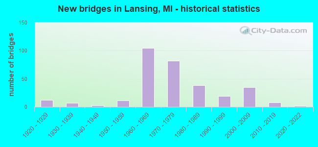
- New bridges - historical statistics
- 121920-1929
- 71930-1939
- 31940-1949
- 111950-1959
- 1051960-1969
- 821970-1979
- 381980-1989
- 191990-1999
- 352000-2009
- 82010-2019
- 22020-2022
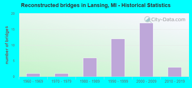
- Reconstructed bridges - Historical Statistics
- 11960-1969
- 11970-1979
- 61980-1989
- 121990-1999
- 172000-2009
- 32010-2019
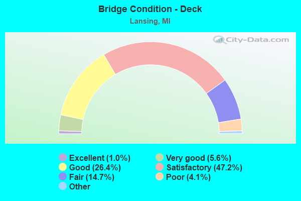
- Bridge Condition - Deck
- 1.0%Excellent
- 5.6%Very good
- 26.4%Good
- 47.2%Satisfactory
- 14.7%Fair
- 4.1%Poor
- 1.0%Serious
- 0.5%Critical
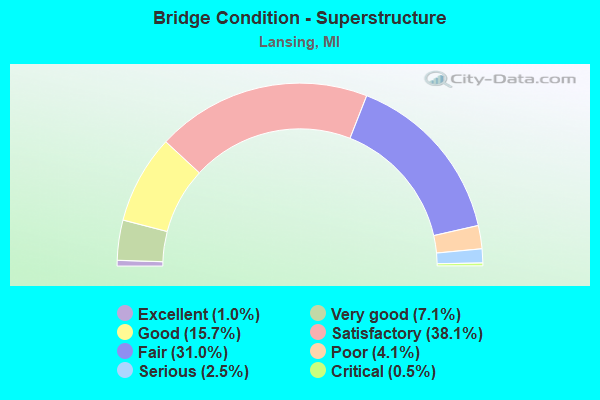
- Bridge Condition - Superstructure
- 1.0%Excellent
- 7.1%Very good
- 15.7%Good
- 38.1%Satisfactory
- 31.0%Fair
- 4.1%Poor
- 2.5%Serious
- 0.5%Critical
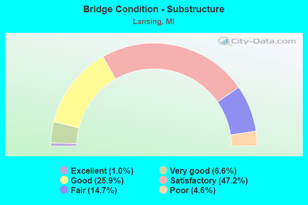
- Bridge Condition - Substructure
- 1.0%Excellent
- 6.6%Very good
- 25.9%Good
- 47.2%Satisfactory
- 14.7%Fair
- 4.6%Poor
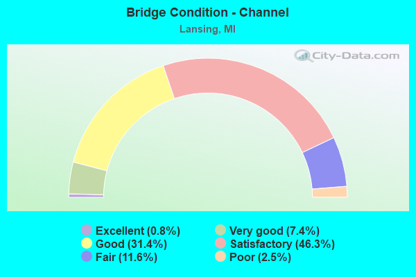
- Bridge Condition - Channel
- 0.8%Excellent
- 7.4%Very good
- 31.4%Good
- 46.3%Satisfactory
- 11.6%Fair
- 2.5%Poor
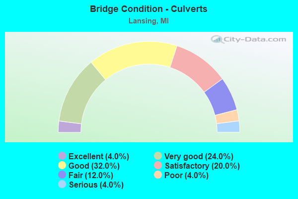
- Bridge Condition - Culverts
- 4.0%Excellent
- 24.0%Very good
- 32.0%Good
- 20.0%Satisfactory
- 12.0%Fair
- 4.0%Poor
- 4.0%Serious
Find on map >> Show street view
Structure Number: 9397, Location: 0.1 MI N OF GEDDES ROAD (Lat: 43.432589, Lng: -84.180569), Route carried "on" structure: ServiceCounty highway , Year Built: 2013, Status: Open, Structure Length: 0.69m (2.26ft), Average Daily Traffic: 38 (year 2013), Truck Traffic: 5%, Average Future Daily Traffic: 85 (year 2033), Design Load: Greater than HL93, Features Intersected: MCCLELLAN RUN DRAIN, Facility Carried by Structure: PRUESS ROAD
Minimum Vertical Clearance: 30.48m (100.00ft), Kilometerpoint: 0.201, Lanes on structure: 2, Owner: County Highway Agency, Approaching Roadway Width: 7.9m (25.9ft), Skew: 1 degrees, Material/Design: Concrete, Design/Construction: Culvert, Number Of Spans In Main Unit: 1, Length of Maximum Span: 6.3m (20.7ft), Curb-To-Curb Width: 7.9m (25.9ft), Out-to-Out Width: 15.8m (51.8ft)
Condition: Channel: Good, Culverts: Very good, Operating Rating: 77.8 metric tons, Method Used To Determine Operating Rating: Load and Resistance Factor Rating (LRFR) rating reported by rating factor(RF) method using HL-93 loadings, Inventory Rating: 59.9 metric tons, Method Used To Determine Inventory Rating: Load and Resistance Factor Rating (LRFR) rating reported by rating factor(RF) method using HL-93 loadings, Structural Evaluation: Equal to present desirable criteria, Waterway Adequacy: Equal to present minimum criteria, Approach Roadway Alignment: Equal to present minimum criteria, Designated Inspection Frequency: Every 24 months, Inspection Date: August 2021, Wearing Surface/Protective System: Wearing Surface: Gravel
Find on map >> Show street view
Structure Number: 9399, Location: 0.6 MI E OF SHARON ROAD (Lat: 43.217725, Lng: -84.104900), Route carried "on" structure: ServiceCounty highway , Year Built: 2016, Status: Open, Structure Length: 4.27m (14.01ft), Average Daily Traffic: 1,358 (year 2014), Truck Traffic: 3%, Average Future Daily Traffic: 1,657 (year 2034), Design Load: Greater than HL93, Features Intersected: SHIAWASSEE RIVER, Facility Carried by Structure: GARY ROAD
Minimum Vertical Clearance: 30+ m (98+ ft), Kilometerpoint: 21.432, Lanes on structure: 2, Owner: County Highway Agency, Approaching Roadway Width: 9.3m (30.5ft), Skew: 1 degrees, Material/Design: Prestressed concrete, Design/Construction: Stringer/Multi-beam, Number Of Spans In Main Unit: 1, Number Of Approach Spans: 2, Length of Maximum Span: 25.6m (84.0ft), Curb-To-Curb Width: 9.2m (30.2ft), Out-to-Out Width: 10.2m (33.5ft)
Condition: Deck: Very good, Superstructure: Very good, Substructure: Very good, Channel: Good, Operating Rating: 82.9 metric tons, Method Used To Determine Operating Rating: Load and Resistance Factor Rating (LRFR) rating reported by rating factor(RF) method using HL-93 loadings, Inventory Rating: 43.4 metric tons, Method Used To Determine Inventory Rating: Load and Resistance Factor Rating (LRFR) rating reported by rating factor(RF) method using HL-93 loadings, Structural Evaluation: Equal to present desirable criteria, Deck Geometry: Somewhat better than minimum adequacy, Waterway Adequacy: Equal to present desirable criteria, Approach Roadway Alignment: Equal to present desirable criteria, Designated Inspection Frequency: Every 24 months, Inspection Date: July 2020, Deck Structure Type: Concrete Cast-file-Place, Wearing Surface/Protective System: Wearing Surface: Monolithic Concrete, Deck Protection: Epoxy Coated Reinforcing
Find on map >> Show street view
Structure Number: 9401, Location: 0.4 MI E OF MCKEIGHAN RD (Lat: 43.247047, Lng: -84.122350), Route carried "on" structure: ServiceCounty highway , Year Built: 2007, Status: Open, Structure Length: 0.76m (2.49ft), Average Daily Traffic: 331 (year 2008), Truck Traffic: 5%, Average Future Daily Traffic: 348 (year 2018), Design Load: HS 20, Features Intersected: CARSON DRAIN, Facility Carried by Structure: MARION ROAD
Minimum Vertical Clearance: 30.48m (100.00ft), Kilometerpoint: 3.837, Lanes on structure: 2, Owner: County Highway Agency, Approaching Roadway Width: 9.1m (29.9ft), Material/Design: Concrete, Design/Construction: Culvert, Number Of Spans In Main Unit: 1, Length of Maximum Span: 7.0m (23.0ft), Curb-To-Curb Width: 9.1m (29.9ft), Out-to-Out Width: 9.9m (32.5ft)
Condition: Channel: Good, Culverts: Good, Operating Rating: 86.8 metric tons, Method Used To Determine Operating Rating: Load Factor (LF) rating reported by rating factor (RF) method using MS18 loading, Inventory Rating: 51.8 metric tons, Method Used To Determine Inventory Rating: Load Factor (LF) rating reported by rating factor (RF) method using MS18 loading, Structural Evaluation: Better than present minimum criteria, Deck Geometry: Equal to present minimum criteria, Waterway Adequacy: Equal to present desirable criteria, Approach Roadway Alignment: Equal to present desirable criteria, Designated Inspection Frequency: Every 24 months, Inspection Date: May 2021, Deck Structure Type: Concrete Cast-file-Place, Wearing Surface/Protective System: Wearing Surface: Integral Concrete
Find on map >> Show street view
Structure Number: 9402, Location: 0.3 MI E OF STUART ROAD (Lat: 43.262911, Lng: -84.084325), Route carried "on" structure: ServiceCounty highway , Year Built: 1999, Status: Open, Structure Length: 0.61m (2.00ft), Average Daily Traffic: 20 (year 2006), Average Future Daily Traffic: 21 (year 2016), Design Load: H 15, Features Intersected: BEAR CREEK, Facility Carried by Structure: VERNE ROAD
Minimum Vertical Clearance: 30.48m (100.00ft), Kilometerpoint: 0.513, Lanes on structure: 2, Owner: County Highway Agency, Approaching Roadway Width: 5.5m (18.0ft), Skew: 3 degrees, Material/Design: Concrete, Design/Construction: Culvert, Number Of Spans In Main Unit: 1, Length of Maximum Span: 6.1m (20.0ft), Curb-To-Curb Width: 4.6m (15.1ft), Out-to-Out Width: 4.8m (15.7ft)
Condition: Channel: Satisfactory, Culverts: Satisfactory, Operating Rating: 79.7 metric tons, Method Used To Determine Operating Rating: Load Factor (LF) rating reported by rating factor (RF) method using MS18 loading, Inventory Rating: 47.6 metric tons, Method Used To Determine Inventory Rating: Load Factor (LF) rating reported by rating factor (RF) method using MS18 loading, Structural Evaluation: Equal to present minimum criteria, Waterway Adequacy: Equal to present minimum criteria, Approach Roadway Alignment: Somewhat better than minimum adequacy, Designated Inspection Frequency: Every 24 months, Inspection Date: May 2021, Deck Structure Type: Concrete Cast-file-Place, Wearing Surface/Protective System: Wearing Surface: Monolithic Concrete
Find on map >> Show street view
Structure Number: 9404, Location: 0.7 MI N OF BURT ROAD (Lat: 43.242128, Lng: -84.148797), Route carried "on" structure: ServiceCounty highway , Year Built: 1973, Status: Open, Structure Length: 0.82m (2.69ft), Average Daily Traffic: 60 (year 2008), Truck Traffic: 5%, Average Future Daily Traffic: 63 (year 2018), Design Load: H 20, Features Intersected: PICKEREL CREEK, Facility Carried by Structure: FRANDSCHE ROAD
Minimum Vertical Clearance: 30.48m (100.00ft), Kilometerpoint: 2.886, Lanes on structure: 2, Owner: County Highway Agency, Approaching Roadway Width: 8.5m (27.9ft), Skew: 2 degrees, Material/Design: Steel, Design/Construction: Stringer/Multi-beam, Number Of Spans In Main Unit: 1, Length of Maximum Span: 7.3m (24.0ft), Curb-To-Curb Width: 8.2m (26.9ft), Out-to-Out Width: 8.5m (27.9ft)
Condition: Deck: Fair, Superstructure: Fair, Substructure: Fair, Channel: Satisfactory, Operating Rating: 30.9 metric tons, Method Used To Determine Operating Rating: Allowable Stress (AS), Inventory Rating: 21.8 metric tons, Method Used To Determine Inventory Rating: Allowable Stress (AS), Structural Evaluation: Somewhat better than minimum adequacy, Deck Geometry: Equal to present minimum criteria, Waterway Adequacy: Equal to present desirable criteria, Approach Roadway Alignment: Better than present minimum criteria, Designated Inspection Frequency: Every 24 months, Inspection Date: May 2021, Deck Structure Type: Corrugated Steel, Wearing Surface/Protective System: Wearing Surface: Bituminous
Find on map >> Show street view
Structure Number: 9419, Location: 0.2 MI E OF MARSHALL ROAD (Lat: 43.294300, Lng: -83.849131), Route carried "on" structure: County highway 7336, Year Built: 2005, Status: Open, Structure Length: 0.83m (2.72ft), Average Daily Traffic: 118 (year 2017), Truck Traffic: 5%, Average Future Daily Traffic: 124 (year 2027), Design Load: HS 20, Features Intersected: BIRCH RUN CREEK, Facility Carried by Structure: BUSCH ROAD
Minimum Vertical Clearance: 30.48m (100.00ft), Kilometerpoint: 5.272, Lanes on structure: 2, Owner: County Highway Agency, Approaching Roadway Width: 6.1m (20.0ft), Material/Design: Concrete, Design/Construction: Culvert, Number Of Spans In Main Unit: 1, Length of Maximum Span: 7.6m (24.9ft), Out-to-Out Width: 17.1m (56.1ft)
Condition: Channel: Satisfactory, Culverts: Good, Operating Rating: 67.1 metric tons, Method Used To Determine Operating Rating: Load Factor (LF) rating reported by rating factor (RF) method using MS18 loading, Inventory Rating: 40.2 metric tons, Method Used To Determine Inventory Rating: Load Factor (LF) rating reported by rating factor (RF) method using MS18 loading, Structural Evaluation: Better than present minimum criteria, Waterway Adequacy: Equal to present minimum criteria, Approach Roadway Alignment: Equal to present desirable criteria, Designated Inspection Frequency: Every 24 months, Inspection Date: May 2020, Deck Structure Type: Other, Wearing Surface/Protective System: Wearing Surface: Bituminous
Find on map >> Show street view
Structure Number: 9422, Location: 0.4 MI N OF BUSCH ROAD (Lat: 43.300517, Lng: -83.874561), Route carried "on" structure: ServiceCounty highway , Year Built: 1990, Status: Open, Structure Length: 0.88m (2.89ft), Average Daily Traffic: 224 (year 2007), Truck Traffic: 5%, Average Future Daily Traffic: 235 (year 2017), Design Load: HS 20+Mod, Features Intersected: BIRCH RUN CREEK, Facility Carried by Structure: PETTIT ROAD
Minimum Vertical Clearance: 30.48m (100.00ft), Kilometerpoint: 3.903, Lanes on structure: 2, Owner: County Highway Agency, Approaching Roadway Width: 16.5m (54.1ft), Material/Design: Concrete, Design/Construction: Culvert, Number Of Spans In Main Unit: 1, Length of Maximum Span: 8.2m (26.9ft), Curb-To-Curb Width: 13.7m (44.9ft), Out-to-Out Width: 14.6m (47.9ft)
Condition: Channel: Satisfactory, Culverts: Good, Operating Rating: 60.3 metric tons, Method Used To Determine Operating Rating: Load Factor (LF) rating reported by rating factor (RF) method using MS18 loading, Inventory Rating: 36.0 metric tons, Method Used To Determine Inventory Rating: Load Factor (LF) rating reported by rating factor (RF) method using MS18 loading, Structural Evaluation: Better than present minimum criteria, Deck Geometry: Superior to present desirable criteria, Waterway Adequacy: Better than present minimum criteria, Approach Roadway Alignment: Equal to present desirable criteria, Designated Inspection Frequency: Every 24 months, Inspection Date: May 2020, Deck Structure Type: Concrete Precast Panels, Wearing Surface/Protective System: Wearing Surface: Bituminous
Find on map >> Show street view
Structure Number: 9423, Location: 0.1 MI N OF BIRCH RUN RD (Lat: 43.251189, Lng: -83.854256), Route carried "on" structure: ServiceCounty highway , Year Built: 1976, Status: Open, Structure Length: 1.52m (4.99ft), Average Daily Traffic: 272 (year 2007), Truck Traffic: 5%, Average Future Daily Traffic: 286 (year 2017), Design Load: H 20, Features Intersected: PINE RUN CREEK, Facility Carried by Structure: MARSHALL ROAD
Minimum Vertical Clearance: 30.48m (100.00ft), Kilometerpoint: 3.352, Lanes on structure: 2, Owner: County Highway Agency, Approaching Roadway Width: 9.8m (32.2ft), Skew: 1 degrees, Material/Design: Steel, Design/Construction: Stringer/Multi-beam, Number Of Spans In Main Unit: 1, Length of Maximum Span: 14.6m (47.9ft), Curb-To-Curb Width: 8.5m (27.9ft), Out-to-Out Width: 9.0m (29.5ft)
Condition: Deck: Good, Superstructure: Poor, Substructure: Poor, Channel: Satisfactory, Operating Rating: 60.9 metric tons, Method Used To Determine Operating Rating: Load Factor (LF) rating reported by rating factor (RF) method using MS18 loading, Inventory Rating: 36.6 metric tons, Method Used To Determine Inventory Rating: Load Factor (LF) rating reported by rating factor (RF) method using MS18 loading, Structural Evaluation: Meets minimum limits, Deck Geometry: Equal to present minimum criteria, Waterway Adequacy: Equal to present desirable criteria, Approach Roadway Alignment: Equal to present desirable criteria, Designated Inspection Frequency: Every 12 months, Inspection Date: November 2021, Deck Structure Type: Corrugated Steel, Wearing Surface/Protective System: Wearing Surface: Gravel
Find on map >> Show street view
Structure Number: 9433, Location: 0.3 MI N OF SCHOMAKER RD (Lat: 43.406436, Lng: -84.111161), Route carried "on" structure: ServiceCounty highway , Year Built: 1977, Status: Posted for load, Structure Length: 1.22m (4.00ft), Average Daily Traffic: 556 (year 2017), Truck Traffic: 5%, Average Future Daily Traffic: 584 (year 2027), Features Intersected: WILLIAMS CREEK DRAIN, Facility Carried by Structure: THOMAS ROAD
Minimum Vertical Clearance: 30.48m (100.00ft), Kilometerpoint: 4.141, Lanes on structure: 2, Owner: County Highway Agency, Approaching Roadway Width: 12.2m (40.0ft), Skew: 2 degrees, Material/Design: Steel, Design/Construction: Stringer/Multi-beam, Number Of Spans In Main Unit: 1, Length of Maximum Span: 11.5m (37.7ft), Curb-To-Curb Width: 8.5m (27.9ft), Out-to-Out Width: 9.0m (29.5ft)
Condition: Deck: Poor, Superstructure: Serious, Substructure: Poor, Channel: Satisfactory, Operating Rating: 10.7 metric tons, Method Used To Determine Operating Rating: Load Factor (LF) rating reported by rating factor (RF) method using MS18 loading, Inventory Rating: 6.5 metric tons, Method Used To Determine Inventory Rating: Load Factor (LF) rating reported by rating factor (RF) method using MS18 loading, Structural Evaluation: High priority of corrective action, Deck Geometry: Somewhat better than minimum adequacy, Waterway Adequacy: Better than present minimum criteria, Approach Roadway Alignment: Equal to present desirable criteria, Bridge Posting: Required (Relationship of Operating Rating to Maximum Legal Load: > 39.9% below), Designated Inspection Frequency: Every 12 months, Inspection Date: September 2021, Deck Structure Type: Corrugated Steel, Wearing Surface/Protective System: Wearing Surface: Bituminous
Find on map >> Show street view
Structure Number: 9592, Location: SEC 20-29 ELK TWP (Lat: 43.272219, Lng: -82.860803), Route carried "on" structure: County highway , Year Built: 1991, Status: Open, Structure Length: 1.58m (5.18ft), Average Daily Traffic: 300 (year 2010), Truck Traffic: 3%, Average Future Daily Traffic: 540 (year 2030), Design Load: HS 20, Features Intersected: ELK CREEK DRAIN, Facility Carried by Structure: HARRINGTON ROAD
Minimum Vertical Clearance: 30.48m (100.00ft), Kilometerpoint: 6.677, Lanes on structure: 2, Owner: County Highway Agency, Approaching Roadway Width: 7.9m (25.9ft), Material/Design: Wood or Timber, Design/Construction: Slab, Number Of Spans In Main Unit: 3, Length of Maximum Span: 7.3m (24.0ft), Curb-To-Curb Width: 9.8m (32.2ft), Out-to-Out Width: 10.4m (34.1ft)
Condition: Deck: Good, Superstructure: Good, Substructure: Good, Channel: Satisfactory, Operating Rating: 53.6 metric tons, Method Used To Determine Operating Rating: Load Factor (LF), Inventory Rating: 29.8 metric tons, Method Used To Determine Inventory Rating: Load Factor (LF), Structural Evaluation: Better than present minimum criteria, Deck Geometry: Better than present minimum criteria, Waterway Adequacy: Equal to present desirable criteria, Approach Roadway Alignment: Equal to present desirable criteria, Designated Inspection Frequency: Every 24 months, Inspection Date: June 2020, Deck Structure Type: Wood or Timber, Wearing Surface/Protective System: Wearing Surface: Bituminous
Find on map >> Show street view
Structure Number: 9603, Location: SEC 18-19 ELMER TWP (Lat: 43.373619, Lng: -82.977153), Route carried "on" structure: County highway , Year Built: 1981, Status: Open, Structure Length: 2.84m (9.32ft), Average Daily Traffic: 225 (year 2016), Truck Traffic: 10%, Average Future Daily Traffic: 405 (year 2036), Design Load: H 20, Features Intersected: S BR CASS RIVER I/C DRN, Facility Carried by Structure: WALKER ROAD
Minimum Vertical Clearance: 30.48m (100.00ft), Kilometerpoint: 10.379, Lanes on structure: 2, Owner: County Highway Agency, Approaching Roadway Width: 7.9m (25.9ft), Material/Design: Prestressed concrete, Design/Construction: Tee Beam, Number Of Spans In Main Unit: 3, Length of Maximum Span: 9.5m (31.2ft), Curb-To-Curb Width: 9.3m (30.5ft), Out-to-Out Width: 9.9m (32.5ft)
Condition: Deck: Satisfactory, Superstructure: Satisfactory, Substructure: Good, Channel: Satisfactory, Operating Rating: 37.6 metric tons, Method Used To Determine Operating Rating: Load and Resistance Factor Rating (LRFR) rating reported by rating factor(RF) method using HL-93 loadings, Inventory Rating: 28.8 metric tons, Method Used To Determine Inventory Rating: Load and Resistance Factor Rating (LRFR) rating reported by rating factor(RF) method using HL-93 loadings, Structural Evaluation: Equal to present minimum criteria, Deck Geometry: Equal to present minimum criteria, Waterway Adequacy: Better than present minimum criteria, Approach Roadway Alignment: Equal to present desirable criteria, Designated Inspection Frequency: Every 24 months, Inspection Date: April 2020, Deck Structure Type: Concrete Precast Panels, Wearing Surface/Protective System: Wearing Surface: Bituminous, Deck Protection: Epoxy Coated Reinforcing
Find on map >> Show street view
Structure Number: 9604, Location: SEC 7-18 ELMER TWP (Lat: 43.388372, Lng: -82.969633), Route carried "on" structure: County highway , Year Built: 2005, Status: Open, Structure Length: 3.47m (11.38ft), Average Daily Traffic: 240 (year 2016), Truck Traffic: 5%, Average Future Daily Traffic: 435 (year 2036), Design Load: HS 20, Features Intersected: S BR CASS RIVER I/C DRN, Facility Carried by Structure: COOPER ROAD
Minimum Vertical Clearance: 30.48m (100.00ft), Kilometerpoint: 11.008, Lanes on structure: 2, Owner: County Highway Agency, Approaching Roadway Width: 9.1m (29.9ft), Skew: 3 degrees, Material/Design: Prestressed concrete, Design/Construction: Box Beam or Girders - Multiple, Number Of Spans In Main Unit: 2, Length of Maximum Span: 17.3m (56.8ft), Curb-To-Curb Width: 8.9m (29.2ft), Out-to-Out Width: 9.6m (31.5ft)
Condition: Deck: Good, Superstructure: Good, Substructure: Very good, Channel: Good, Operating Rating: 53.1 metric tons, Method Used To Determine Operating Rating: Load and Resistance Factor Rating (LRFR) rating reported by rating factor(RF) method using HL-93 loadings, Inventory Rating: 37.6 metric tons, Method Used To Determine Inventory Rating: Load and Resistance Factor Rating (LRFR) rating reported by rating factor(RF) method using HL-93 loadings, Structural Evaluation: Better than present minimum criteria, Deck Geometry: Equal to present minimum criteria, Waterway Adequacy: Equal to present desirable criteria, Approach Roadway Alignment: Equal to present desirable criteria, Designated Inspection Frequency: Every 24 months, Inspection Date: April 2020, Deck Structure Type: Concrete Precast Panels, Wearing Surface/Protective System: Wearing Surface: Monolithic Concrete, Membrane: Preformed Fabric, Deck Protection: Epoxy Coated Reinforcing
Find on map >> Show street view
Structure Number: 9605, Location: SEC 5-8 ELMER TWP (Lat: 43.403167, Lng: -82.960814), Route carried "on" structure: County highway , Year Built: 1986, Status: Open, Structure Length: 2.58m (8.46ft), Average Daily Traffic: 225 (year 2016), Truck Traffic: 10%, Average Future Daily Traffic: 405 (year 2036), Design Load: HS 20, Features Intersected: S BR CASS RIVER I/C DRN, Facility Carried by Structure: MILLER ROAD
Minimum Vertical Clearance: 30.48m (100.00ft), Kilometerpoint: 8.591, Lanes on structure: 2, Owner: County Highway Agency, Approaching Roadway Width: 8.5m (27.9ft), Material/Design: Prestressed concrete, Design/Construction: Box Beam or Girders - Multiple, Number Of Spans In Main Unit: 1, Length of Maximum Span: 25.4m (83.3ft), Curb-To-Curb Width: 9.4m (30.8ft), Out-to-Out Width: 9.5m (31.2ft)
Condition: Deck: Good, Superstructure: Good, Substructure: Very good, Channel: Satisfactory, Operating Rating: 93.4 metric tons, Method Used To Determine Operating Rating: Load Factor (LF), Inventory Rating: 56.1 metric tons, Method Used To Determine Inventory Rating: Load Factor (LF), Structural Evaluation: Better than present minimum criteria, Deck Geometry: Equal to present minimum criteria, Waterway Adequacy: Equal to present desirable criteria, Approach Roadway Alignment: Equal to present desirable criteria, Designated Inspection Frequency: Every 24 months, Inspection Date: April 2020, Deck Structure Type: Concrete Precast Panels, Wearing Surface/Protective System: Wearing Surface: Bituminous, Membrane: Preformed Fabric, Deck Protection: Epoxy Coated Reinforcing
Find on map >> Show street view
Structure Number: 9827, Location: 3 MI N & .3 MI E OF PERRY (Lat: 42.870569, Lng: -84.230703), Route carried "on" structure: County highway , Year Built: 1965, Status: Posted for load, Structure Length: 0.91m (2.99ft), Average Daily Traffic: 370 (year 1992), Truck Traffic: 5%, Average Future Daily Traffic: 665 (year 2012), Design Load: HS 20, Features Intersected: AUSTIN CREEK, Facility Carried by Structure: TYRRELL RD
Minimum Vertical Clearance: 30.48m (100.00ft), Kilometerpoint: 2.857, Lanes on structure: 2, Owner: County Highway Agency, Approaching Roadway Width: 7.0m (23.0ft), Material/Design: Wood or Timber, Design/Construction: Culvert, Number Of Spans In Main Unit: 3, Length of Maximum Span: 2.1m (6.9ft)
Condition: Channel: Satisfactory, Culverts: Satisfactory, Operating Rating: 19.8 metric tons, Method Used To Determine Operating Rating: Allowable Stress (AS) rating reported by rating factor (RF) method using MS18 loading, Inventory Rating: 14.3 metric tons, Method Used To Determine Inventory Rating: Allowable Stress (AS) rating reported by rating factor (RF) method using MS18 loading, Structural Evaluation: Meets minimum limits, Waterway Adequacy: Meets minimum limits, Approach Roadway Alignment: Equal to present desirable criteria, Bridge Posting: Required (Relationship of Operating Rating to Maximum Legal Load: 0.1 - 9.9% below), Designated Inspection Frequency: Every 12 months, Inspection Date: April 2021, Deck Structure Type: Wood or Timber, Wearing Surface/Protective System: Wearing Surface: Gravel
Find on map >> Show street view
Structure Number: 9839, Location: 1.1 MI SE OF NEW LOTHROP (Lat: 43.102267, Lng: -83.957858), Route carried "on" structure: County highway , Year Built: 1990, Status: Posted for load, Structure Length: 2.80m (9.19ft), Average Daily Traffic: 128 (year 1998), Truck Traffic: 5%, Average Future Daily Traffic: 230 (year 2018), Design Load: HS 20+Mod, Features Intersected: MISTEGUAY CREEK, Facility Carried by Structure: ALLAN RD
Minimum Vertical Clearance: 30.48m (100.00ft), Kilometerpoint: 13.942, Lanes on structure: 2, Owner: County Highway Agency, Approaching Roadway Width: 11.0m (36.1ft), Skew: 1 degrees, Material/Design: Prestressed concrete, Design/Construction: Box Beam or Girders - Multiple, Number Of Spans In Main Unit: 1, Length of Maximum Span: 26.8m (87.9ft), Curb-To-Curb Width: 11.0m (36.1ft), Out-to-Out Width: 11.3m (37.1ft)
Condition: Deck: Good, Superstructure: Good, Substructure: Good, Channel: Good, Operating Rating: 49.6 metric tons, Method Used To Determine Operating Rating: Load Factor (LF) rating reported by rating factor (RF) method using MS18 loading, Inventory Rating: 25.9 metric tons, Method Used To Determine Inventory Rating: Load Factor (LF) rating reported by rating factor (RF) method using MS18 loading, Structural Evaluation: Equal to present minimum criteria, Deck Geometry: Equal to present desirable criteria, Waterway Adequacy: Superior to present desirable criteria, Approach Roadway Alignment: Equal to present desirable criteria, Bridge Posting: Required (Relationship of Operating Rating to Maximum Legal Load: 10.0 - 19.9% below), Designated Inspection Frequency: Every 24 months, Inspection Date: April 2020, Deck Structure Type: Concrete Precast Panels, Wearing Surface/Protective System: Wearing Surface: Bituminous, Membrane: Preformed Fabric, Deck Protection: Epoxy Coated Reinforcing
Find on map >> Show street view
Structure Number: 9881, Location: 3.3 MI S OF LENNON (Lat: 42.935953, Lng: -83.929389), Route carried "on" structure: County highway , Year Built: 1994, Status: Open, Structure Length: 0.76m (2.49ft), Average Daily Traffic: 367 (year 1998), Average Future Daily Traffic: 660 (year 2018), Design Load: HS 20, Features Intersected: WEBB CREEK, Facility Carried by Structure: COUNTY LINE RD
Minimum Vertical Clearance: 30.48m (100.00ft), Kilometerpoint: 12.380, Lanes on structure: 2, Owner: County Highway Agency, Approaching Roadway Width: 9.1m (29.9ft), Material/Design: Concrete, Design/Construction: Culvert, Number Of Spans In Main Unit: 1, Length of Maximum Span: 7.6m (24.9ft), Curb-To-Curb Width: 9.1m (29.9ft), Out-to-Out Width: 10.0m (32.8ft)
Condition: Channel: Satisfactory, Culverts: Good, Operating Rating: 63.5 metric tons, Method Used To Determine Operating Rating: Load and Resistance Factor Rating (LRFR) rating reported by rating factor(RF) method using HL-93 loadings, Inventory Rating: 48.9 metric tons, Method Used To Determine Inventory Rating: Load and Resistance Factor Rating (LRFR) rating reported by rating factor(RF) method using HL-93 loadings, Structural Evaluation: Better than present minimum criteria, Deck Geometry: Equal to present minimum criteria, Waterway Adequacy: Better than present minimum criteria, Approach Roadway Alignment: Equal to present desirable criteria, Designated Inspection Frequency: Every 24 months, Inspection Date: April 2020, Wearing Surface/Protective System: Wearing Surface: Monolithic Concrete, Deck Protection: Epoxy Coated Reinforcing
Find on map >> Show street view
Structure Number: 9882, Location: 1 MI S OF SHAFTSBURG (Lat: 42.790514, Lng: -84.290775), Route carried "on" structure: County highway , Year Built: 2005, Status: Open, Structure Length: 1.40m (4.59ft), Average Daily Traffic: 449 (year 2004), Truck Traffic: 2%, Average Future Daily Traffic: 811 (year 2024), Design Load: H 20, Features Intersected: S BR LOOKINGGLASS RIVER, Facility Carried by Structure: BRADEN RD
Minimum Vertical Clearance: 30.48m (100.00ft), Kilometerpoint: 0.158, Lanes on structure: 2, Owner: County Highway Agency, Approaching Roadway Width: 8.8m (28.9ft), Skew: 3 degrees, Material/Design: Prestressed concrete, Design/Construction: Box Beam or Girders - Multiple, Number Of Spans In Main Unit: 1, Length of Maximum Span: 12.8m (42.0ft), Curb-To-Curb Width: 8.8m (28.9ft), Out-to-Out Width: 9.5m (31.2ft)
Condition: Deck: Very good, Superstructure: Good, Substructure: Very good, Channel: Satisfactory, Operating Rating: 55.7 metric tons, Method Used To Determine Operating Rating: Load Factor (LF) rating reported by rating factor (RF) method using MS18 loading, Inventory Rating: 33.4 metric tons, Method Used To Determine Inventory Rating: Load Factor (LF) rating reported by rating factor (RF) method using MS18 loading, Structural Evaluation: Better than present minimum criteria, Deck Geometry: Somewhat better than minimum adequacy, Waterway Adequacy: Better than present minimum criteria, Approach Roadway Alignment: Equal to present desirable criteria, Designated Inspection Frequency: Every 24 months, Inspection Date: April 2020, Deck Structure Type: Concrete Cast-file-Place, Wearing Surface/Protective System: Wearing Surface: Monolithic Concrete, Deck Protection: Epoxy Coated Reinforcing
Find on map >> Show street view
Structure Number: 9929, Location: 1.5 MI W OF I-94 (Lat: 42.971825, Lng: -82.509133), Route carried "on" structure: Interstate 69, Year Built: 1966, Year Reconstructed: 2007, Status: Open, Structure Length: 7.43m (24.38ft), Average Daily Traffic: 9,344 (year 2007), Truck Traffic: 18%, Average Future Daily Traffic: 11,976 (year 2018), Design Load: HS 20, Features Intersected: CSX RR
Minimum Vertical Clearance: 30.48m (100.00ft), Kilometerpoint: 40.668, Lanes on structure: 2, Base Highway Network: Yes (Inventory Route: 96, Subroute: 6), Owner: State Highway Agency, Approaching Roadway Width: 12.2m (40.0ft), Skew: 5 degrees, Material/Design: Steel, Design/Construction: Stringer/Multi-beam, Number Of Spans In Main Unit: 3, Length of Maximum Span: 25.2m (82.7ft), Curb-To-Curb Width: 11.7m (38.4ft), Out-to-Out Width: 12.9m (42.3ft)
Condition: Deck: Satisfactory, Superstructure: Satisfactory, Substructure: Satisfactory, Operating Rating: 69.3 metric tons, Method Used To Determine Operating Rating: Load Factor (LF) rating reported by rating factor (RF) method using MS18 loading, Inventory Rating: 41.5 metric tons, Method Used To Determine Inventory Rating: Load Factor (LF) rating reported by rating factor (RF) method using MS18 loading, Structural Evaluation: Equal to present minimum criteria, Deck Geometry: Equal to present minimum criteria, Approach Roadway Alignment: Better than present minimum criteria, Designated Inspection Frequency: Every 24 months, Inspection Date: October 2021, Deck Structure Type: Concrete Cast-file-Place, Wearing Surface/Protective System: Wearing Surface: Latex Concrete
Find on map >> Show street view
Structure Number: 10115, Location: SEC. 4-9 BERLIN TWP. (Lat: 42.967419, Lng: -82.939547), Route carried "on" structure: ServiceCounty highway , Year Built: 1999, Status: Open, Structure Length: 2.40m (7.87ft), Average Daily Traffic: 110 (year 1994), Truck Traffic: 1%, Average Future Daily Traffic: 224 (year 2018), Design Load: HS 20, Features Intersected: BELLE RIVER, Facility Carried by Structure: TERRY ROAD
Minimum Vertical Clearance: 30.48m (100.00ft), Kilometerpoint: 2.181, Lanes on structure: 2, Owner: County Highway Agency, Approaching Roadway Width: 7.9m (25.9ft), Skew: 2 degrees, Material/Design: Prestressed concrete, Design/Construction: Box Beam or Girders - Single/Spread, Number Of Spans In Main Unit: 1, Length of Maximum Span: 23.5m (77.1ft), Curb-To-Curb Width: 8.9m (29.2ft), Out-to-Out Width: 9.4m (30.8ft)
Condition: Deck: Very good, Superstructure: Very good, Substructure: Good, Channel: Very good, Operating Rating: 83.3 metric tons, Method Used To Determine Operating Rating: Load Factor (LF) rating reported by rating factor (RF) method using MS18 loading, Inventory Rating: 45.7 metric tons, Method Used To Determine Inventory Rating: Load Factor (LF) rating reported by rating factor (RF) method using MS18 loading, Structural Evaluation: Better than present minimum criteria, Deck Geometry: Equal to present minimum criteria, Waterway Adequacy: Equal to present desirable criteria, Approach Roadway Alignment: Equal to present desirable criteria, Designated Inspection Frequency: Every 24 months, Inspection Date: January 2021, Deck Structure Type: Concrete Precast Panels, Wearing Surface/Protective System: Wearing Surface: Monolithic Concrete, Deck Protection: Epoxy Coated Reinforcing
Find on map >> Show street view
Structure Number: 10117, Location: SEC. 10-11 BERLIN TWP. (Lat: 42.961542, Lng: -82.905542), Route carried "on" structure: ServiceCounty highway , Year Built: 1948, Status: Open, Structure Length: 2.43m (7.97ft), Average Daily Traffic: 180 (year 2020), Truck Traffic: 5%, Average Future Daily Traffic: 265 (year 2040), Design Load: HS 20+Mod, Features Intersected: BELLE RIVER, Facility Carried by Structure: SPERRY ROAD
Minimum Vertical Clearance: 30.48m (100.00ft), Kilometerpoint: 5.736, Lanes on structure: 2, Owner: County Highway Agency, Approaching Roadway Width: 8.5m (27.9ft), Material/Design: Steel, Design/Construction: Stringer/Multi-beam, Number Of Spans In Main Unit: 2, Length of Maximum Span: 12.2m (40.0ft), Curb-To-Curb Width: 8.5m (27.9ft), Out-to-Out Width: 10.2m (33.5ft)
Condition: Deck: Fair, Superstructure: Good, Substructure: Satisfactory, Channel: Satisfactory, Operating Rating: 76.1 metric tons, Method Used To Determine Operating Rating: Load Factor (LF) rating reported by rating factor (RF) method using MS18 loading, Inventory Rating: 45.7 metric tons, Method Used To Determine Inventory Rating: Load Factor (LF) rating reported by rating factor (RF) method using MS18 loading, Structural Evaluation: Equal to present minimum criteria, Deck Geometry: Equal to present minimum criteria, Waterway Adequacy: Equal to present minimum criteria, Approach Roadway Alignment: Better than present minimum criteria, Length Of Structure Improvement: 4.57m (14.99ft), Designated Inspection Frequency: Every 24 months, Inspection Date: January 2021, Roadway Improvement Cost: $9,000, Total Project Cost: $10,000, Deck Structure Type: Concrete Cast-file-Place, Wearing Surface/Protective System: Wearing Surface: Monolithic Concrete
Find on map >> Show street view
Structure Number: 10118, Location: SEC. 11-12 BERLIN TWP. (Lat: 42.957567, Lng: -82.886072), Route carried "on" structure: ServiceCounty highway , Year Built: 1981, Status: Posted for load, Structure Length: 2.44m (8.01ft), Average Daily Traffic: 290 (year 1994), Truck Traffic: 3%, Average Future Daily Traffic: 350 (year 2014), Design Load: HS 20, Features Intersected: BELLE RIVER, Facility Carried by Structure: BERVILLE ROAD
Minimum Vertical Clearance: 30.48m (100.00ft), Kilometerpoint: 5.317, Lanes on structure: 2, Owner: County Highway Agency, Approaching Roadway Width: 7.3m (24.0ft), Skew: 2 degrees, Material/Design: Prestressed concrete, Design/Construction: Box Beam or Girders - Multiple, Number Of Spans In Main Unit: 1, Length of Maximum Span: 24.0m (78.7ft), Curb-To-Curb Width: 9.5m (31.2ft), Out-to-Out Width: 10.5m (34.4ft)
Condition: Deck: Good, Superstructure: Good, Substructure: Very good, Channel: Good, Operating Rating: 54.1 metric tons, Method Used To Determine Operating Rating: Load Factor (LF) rating reported by rating factor (RF) method using MS18 loading, Inventory Rating: 24.3 metric tons, Method Used To Determine Inventory Rating: Load Factor (LF) rating reported by rating factor (RF) method using MS18 loading, Structural Evaluation: Equal to present minimum criteria, Deck Geometry: Equal to present minimum criteria, Waterway Adequacy: Equal to present minimum criteria, Approach Roadway Alignment: Equal to present minimum criteria, Bridge Posting: Required (Relationship of Operating Rating to Maximum Legal Load: 20.0 - 29.9% below), Designated Inspection Frequency: Every 24 months, Inspection Date: January 2021, Deck Structure Type: Concrete Cast-file-Place, Wearing Surface/Protective System: Wearing Surface: Bituminous, Membrane: Preformed Fabric
Find on map >> Show street view
Structure Number: 10228, Location: SEC 5-8 ST CLAIR TWP (Lat: 42.888044, Lng: -82.598142), Route carried "on" structure: ServiceCounty highway , Year Built: 2018, Status: Open, Structure Length: 0.78m (2.56ft), Average Daily Traffic: 128 (year 2017), Truck Traffic: 12%, Average Future Daily Traffic: 191 (year 2037), Design Load: Greater than HL93, Features Intersected: HOLLAND DRAIN, Facility Carried by Structure: FRITH ROAD
Minimum Vertical Clearance: 30.48m (100.00ft), Kilometerpoint: 6.652, Lanes on structure: 2, Owner: County Highway Agency, Approaching Roadway Width: 9.1m (29.9ft), Skew: 1 degrees, Material/Design: Aluminum, Iron, Design/Construction: Culvert, Number Of Spans In Main Unit: 1, Length of Maximum Span: 7.8m (25.6ft), Curb-To-Curb Width: 9.1m (29.9ft), Out-to-Out Width: 15.1m (49.5ft)
Condition: Channel: Very good, Culverts: Very good, Operating Rating: 77.1 metric tons, Method Used To Determine Operating Rating: Load and Resistance Factor Rating (LRFR) rating reported by rating factor(RF) method using HL-93 loadings, Inventory Rating: 59.6 metric tons, Method Used To Determine Inventory Rating: Load and Resistance Factor Rating (LRFR) rating reported by rating factor(RF) method using HL-93 loadings, Structural Evaluation: Equal to present desirable criteria, Deck Geometry: Equal to present minimum criteria, Waterway Adequacy: Equal to present minimum criteria, Approach Roadway Alignment: Equal to present minimum criteria, Length Of Structure Improvement: 0.91m (2.99ft), Designated Inspection Frequency: Every 24 months, Inspection Date: July 2021, Bridge Improvement Cost: $200,000, Roadway Improvement Cost: $100,000, Total Project Cost: $300,000, Wearing Surface/Protective System: Wearing Surface: Bituminous
Find on map >> Show street view
Structure Number: 10435, Location: 3.7 MI W OF SANILAC COL (Lat: 43.600697, Lng: -83.186964), Route carried "on" structure: State highway 81, Year Built: 2007, Status: Open, Structure Length: 0.78m (2.56ft), Average Daily Traffic: 6,273 (year 2007), Truck Traffic: 6%, Average Future Daily Traffic: 14,000 (year 2027), Design Load: HS 25 or greater, Features Intersected: MARSH DRAIN
Minimum Vertical Clearance: 30.48m (100.00ft), Kilometerpoint: 36.242, Lanes on structure: 2, Base Highway Network: Yes (Inventory Route: 27, Subroute: 4), Owner: State Highway Agency, Approaching Roadway Width: 14.9m (48.9ft), Material/Design: Concrete, Design/Construction: Culvert, Number Of Spans In Main Unit: 1, Length of Maximum Span: 7.3m (24.0ft), Curb-To-Curb Width: 17.1m (56.1ft), Out-to-Out Width: 18.1m (59.4ft)
Condition: Channel: Good, Culverts: Very good, Operating Rating: 79.4 metric tons, Method Used To Determine Operating Rating: Load Factor (LF) rating reported by rating factor (RF) method using MS18 loading, Inventory Rating: 47.6 metric tons, Method Used To Determine Inventory Rating: Load Factor (LF) rating reported by rating factor (RF) method using MS18 loading, Structural Evaluation: Equal to present desirable criteria, Deck Geometry: Superior to present desirable criteria, Waterway Adequacy: Equal to present desirable criteria, Approach Roadway Alignment: Equal to present desirable criteria, Designated Inspection Frequency: Every 24 months, Inspection Date: August 2020, Deck Structure Type: Concrete Cast-file-Place, Wearing Surface/Protective System: Wearing Surface: Bituminous
Find on map >> Show street view
Structure Number: 10499, Location: SEC 13 TUSCOLA TWP (Lat: 43.351347, Lng: -83.583719), Route carried "on" structure: County highway 7919, Year Built: 1987, Status: Open, Structure Length: 1.22m (4.00ft), Average Daily Traffic: 1,440 (year 2009), Average Future Daily Traffic: 2,600 (year 2029), Design Load: HS 20, Features Intersected: GOODING CREEK, Facility Carried by Structure: VASSAR ROAD
Minimum Vertical Clearance: 30.48m (100.00ft), Kilometerpoint: 14.283, Lanes on structure: 2, Owner: County Highway Agency, Approaching Roadway Width: 9.8m (32.2ft), Material/Design: Prestressed concrete, Design/Construction: Box Beam or Girders - Multiple, Number Of Spans In Main Unit: 1, Length of Maximum Span: 11.8m (38.7ft), Curb-To-Curb Width: 12.2m (40.0ft), Out-to-Out Width: 13.2m (43.3ft)
Condition: Deck: Satisfactory, Superstructure: Good, Substructure: Good, Channel: Satisfactory, Operating Rating: 54.4 metric tons, Method Used To Determine Operating Rating: Load Factor (LF) rating reported by rating factor (RF) method using MS18 loading, Inventory Rating: 32.7 metric tons, Method Used To Determine Inventory Rating: Load Factor (LF) rating reported by rating factor (RF) method using MS18 loading, Structural Evaluation: Better than present minimum criteria, Deck Geometry: Better than present minimum criteria, Waterway Adequacy: Equal to present desirable criteria, Approach Roadway Alignment: Equal to present desirable criteria, Designated Inspection Frequency: Every 24 months, Inspection Date: June 2021, Deck Structure Type: Concrete Precast Panels, Wearing Surface/Protective System: Wearing Surface: Bituminous, Membrane: Preformed Fabric, Deck Protection: Epoxy Coated Reinforcing
Find on map >> Show street view
Structure Number: 10505, Location: SEC 33-34 AKRON TWP (Lat: 43.571931, Lng: -83.524222), Route carried "on" structure: County highway , Year Built: 1994, Status: Open, Structure Length: 1.51m (4.95ft), Average Daily Traffic: 410 (year 2009), Average Future Daily Traffic: 750 (year 2029), Design Load: HS 20, Features Intersected: ALLEN EXTENSION DRAIN, Facility Carried by Structure: RINGLE ROAD
Minimum Vertical Clearance: 30.48m (100.00ft), Kilometerpoint: 0.631, Lanes on structure: 2, Owner: County Highway Agency, Approaching Roadway Width: 8.5m (27.9ft), Skew: 1 degrees, Material/Design: Prestressed concrete, Design/Construction: Tee Beam, Number Of Spans In Main Unit: 2, Length of Maximum Span: 7.3m (24.0ft), Curb-To-Curb Width: 10.2m (33.5ft), Out-to-Out Width: 11.0m (36.1ft)
Condition: Deck: Good, Superstructure: Good, Substructure: Fair, Channel: Poor, Operating Rating: 75.8 metric tons, Method Used To Determine Operating Rating: Load Factor (LF) rating reported by rating factor (RF) method using MS18 loading, Inventory Rating: 45.4 metric tons, Method Used To Determine Inventory Rating: Load Factor (LF) rating reported by rating factor (RF) method using MS18 loading, Structural Evaluation: Somewhat better than minimum adequacy, Deck Geometry: Equal to present minimum criteria, Waterway Adequacy: Better than present minimum criteria, Approach Roadway Alignment: Equal to present desirable criteria, Designated Inspection Frequency: Every 12 months, Inspection Date: April 2021, Deck Structure Type: Concrete Precast Panels, Wearing Surface/Protective System: Wearing Surface: Bituminous, Membrane: Preformed Fabric, Deck Protection: Epoxy Coated Reinforcing
Find on map >> Show street view
Structure Number: 12943, Location: IN LANSING (Lat: 42.725553, Lng: -84.544833), Route carried "on" structure: Interstate 496, Year Built: 2000, Status: Open, Structure Length: 22.87m (75.03ft), Average Daily Traffic: 33,453 (year 2007), Truck Traffic: 7%, Average Future Daily Traffic: 35,237 (year 2018), Design Load: HS 25 or greater, Features Intersected: GR RIV,I-96 BL, RIVER ST
Minimum Vertical Clearance: 30.48m (100.00ft), Kilometerpoint: 4.851, Lanes on structure: 2, Lanes under structure: 7, Base Highway Network: Yes (Inventory Route: 35, Subroute: 10), Owner: State Highway Agency, Approaching Roadway Width: 12.8m (42.0ft), Skew: 9 degrees, Material/Design: Prestressed concrete, Design/Construction: Stringer/Multi-beam, Number Of Spans In Main Unit: 8, Number Of Approach Spans: 1, Length of Maximum Span: 29.6m (97.1ft), Curb-To-Curb Width: 12.8m (42.0ft), Out-to-Out Width: 13.8m (45.3ft)
Condition: Deck: Good, Superstructure: Satisfactory, Substructure: Satisfactory, Channel: Good, Operating Rating: 55.6 metric tons, Method Used To Determine Operating Rating: Load Factor (LF), Inventory Rating: 33.3 metric tons, Method Used To Determine Inventory Rating: Load Factor (LF), Structural Evaluation: Equal to present minimum criteria, Deck Geometry: Equal to present desirable criteria, Underclear: Meets minimum limits, Waterway Adequacy: Equal to present desirable criteria, Approach Roadway Alignment: Equal to present desirable criteria, Designated Inspection Frequency: Every 24 months, Inspection Date: September 2021, Deck Structure Type: Concrete Cast-file-Place, Wearing Surface/Protective System: Wearing Surface: Epoxy Overlay, Deck Protection: Epoxy Coated Reinforcing
Find on map >> Show street view
Structure Number: 12944, Location: IN LANSING (Lat: 42.725447, Lng: -84.544853), Route carried "on" structure: ServiceInterstate 496, Year Built: 2000, Status: Open, Structure Length: 22.63m (74.25ft), Average Daily Traffic: 28,500 (year 1995), Truck Traffic: 8%, Average Future Daily Traffic: 36,704 (year 2015), Design Load: HS 25 or greater, Features Intersected: GR RIV,I-96 BL, RIVER ST
Minimum Vertical Clearance: 30.48m (100.00ft), Kilometerpoint: 0.283, Lanes on structure: 3, Lanes under structure: 7, Owner: State Highway Agency, Approaching Roadway Width: 12.8m (42.0ft), Skew: 9 degrees, Material/Design: Prestressed concrete, Design/Construction: Stringer/Multi-beam, Number Of Spans In Main Unit: 8, Number Of Approach Spans: 1, Length of Maximum Span: 29.6m (97.1ft), Curb-To-Curb Width: 12.8m (42.0ft), Out-to-Out Width: 13.8m (45.3ft)
Condition: Deck: Good, Superstructure: Satisfactory, Substructure: Satisfactory, Channel: Good, Operating Rating: 66.8 metric tons, Method Used To Determine Operating Rating: Load Factor (LF), Inventory Rating: 44.0 metric tons, Method Used To Determine Inventory Rating: Load Factor (LF), Structural Evaluation: Equal to present minimum criteria, Deck Geometry: Meets minimum limits, Underclear: Meets minimum limits, Waterway Adequacy: Equal to present desirable criteria, Approach Roadway Alignment: Equal to present desirable criteria, Designated Inspection Frequency: Every 24 months, Inspection Date: September 2021, Deck Structure Type: Concrete Cast-file-Place, Wearing Surface/Protective System: Wearing Surface: Epoxy Overlay, Deck Protection: Epoxy Coated Reinforcing
Find on map >> Show street view
Structure Number: 12945, Location: IN LANSING (Lat: 42.725753, Lng: -84.544789), Route carried "on" structure: Interstate 496, Year Built: 2000, Status: Open, Structure Length: 23.14m (75.92ft), Average Daily Traffic: 33,453 (year 2007), Truck Traffic: 7%, Average Future Daily Traffic: 35,237 (year 2018), Design Load: HS 25 or greater, Features Intersected: GR RIV,I-96 BL, RIVER ST
Minimum Vertical Clearance: 30.48m (100.00ft), Kilometerpoint: 4.852, Lanes on structure: 2, Lanes under structure: 7, Base Highway Network: Yes (Inventory Route: 35, Subroute: 1), Owner: State Highway Agency, Approaching Roadway Width: 12.8m (42.0ft), Material/Design: Prestressed concrete, Design/Construction: Stringer/Multi-beam, Number Of Spans In Main Unit: 8, Number Of Approach Spans: 1, Length of Maximum Span: 28.8m (94.5ft), Curb-To-Curb Width: 13.8m (45.3ft), Out-to-Out Width: 13.8m (45.3ft)
Condition: Deck: Satisfactory, Superstructure: Satisfactory, Substructure: Satisfactory, Channel: Good, Operating Rating: 63.4 metric tons, Method Used To Determine Operating Rating: Load Factor (LF), Inventory Rating: 37.9 metric tons, Method Used To Determine Inventory Rating: Load Factor (LF), Structural Evaluation: Equal to present minimum criteria, Deck Geometry: Superior to present desirable criteria, Underclear: High priority of corrective action, Waterway Adequacy: Equal to present desirable criteria, Approach Roadway Alignment: Equal to present desirable criteria, Designated Inspection Frequency: Every 24 months, Inspection Date: September 2021, Deck Structure Type: Concrete Cast-file-Place, Wearing Surface/Protective System: Wearing Surface: Epoxy Overlay, Deck Protection: Epoxy Coated Reinforcing
Find on map >> Show street view
Structure Number: 12946, Location: IN LANSING (Lat: 42.725872, Lng: -84.544758), Route carried "on" structure: ServiceInterstate 496, Year Built: 2000, Status: Open, Structure Length: 23.38m (76.71ft), Average Daily Traffic: 28,500 (year 1995), Truck Traffic: 8%, Average Future Daily Traffic: 36,704 (year 2015), Design Load: HS 25 or greater, Features Intersected: GR RIV,I-96 BL, RIVER ST
Minimum Vertical Clearance: 30.48m (100.00ft), Kilometerpoint: 0.206, Lanes on structure: 3, Lanes under structure: 7, Owner: State Highway Agency, Approaching Roadway Width: 12.8m (42.0ft), Material/Design: Prestressed concrete, Design/Construction: Stringer/Multi-beam, Number Of Spans In Main Unit: 8, Number Of Approach Spans: 1, Length of Maximum Span: 28.8m (94.5ft), Curb-To-Curb Width: 13.8m (45.3ft), Out-to-Out Width: 14.8m (48.6ft)
Condition: Deck: Good, Superstructure: Satisfactory, Substructure: Good, Channel: Good, Operating Rating: 74.3 metric tons, Method Used To Determine Operating Rating: Load Factor (LF), Inventory Rating: 44.4 metric tons, Method Used To Determine Inventory Rating: Load Factor (LF), Structural Evaluation: Equal to present minimum criteria, Deck Geometry: Meets minimum limits, Underclear: Meets minimum limits, Waterway Adequacy: Equal to present desirable criteria, Approach Roadway Alignment: Equal to present desirable criteria, Designated Inspection Frequency: Every 24 months, Inspection Date: September 2021, Deck Structure Type: Concrete Cast-file-Place, Wearing Surface/Protective System: Wearing Surface: Epoxy Overlay, Deck Protection: Epoxy Coated Reinforcing
Find on map >> Show street view
Structure Number: 13118, Location: WINDSOR TWP SEC 3-4 (Lat: 42.680739, Lng: -84.662047), Route carried "on" structure: County highway , Year Built: 2004, Status: Open, Structure Length: 3.00m (9.84ft), Average Daily Traffic: 7,624 (year 2013), Truck Traffic: 10%, Average Future Daily Traffic: 9,000 (year 2025), Design Load: HS 25 or greater, Features Intersected: CANADIAN NATIONAL RR, Facility Carried by Structure: CANAL ROAD
Minimum Vertical Clearance: 30.48m (100.00ft), Kilometerpoint: 15.862, Lanes on structure: 4, Owner: County Highway Agency, Approaching Roadway Width: 17.1m (56.1ft), Skew: 3 degrees, Material/Design: Prestressed concrete, Design/Construction: Box Beam or Girders - Multiple, Number Of Spans In Main Unit: 1, Length of Maximum Span: 29.6m (97.1ft), Curb or Sidewalk Widths: Left: 1.8m (5.9ft), Right: 1.8m (5.9ft), Curb-To-Curb Width: 17.1m (56.1ft), Out-to-Out Width: 22.3m (73.2ft)
Condition: Deck: Very good, Superstructure: Very good, Substructure: Very good, Operating Rating: 97.2 metric tons, Method Used To Determine Operating Rating: Load Factor (LF) rating reported by rating factor (RF) method using MS18 loading, Inventory Rating: 71.9 metric tons, Method Used To Determine Inventory Rating: Load Factor (LF) rating reported by rating factor (RF) method using MS18 loading, Structural Evaluation: Equal to present desirable criteria, Deck Geometry: Somewhat better than minimum adequacy, Underclear: Equal to present desirable criteria, Approach Roadway Alignment: Equal to present desirable criteria, Designated Inspection Frequency: Every 24 months, Inspection Date: June 2021, Deck Structure Type: Concrete Cast-file-Place, Wearing Surface/Protective System: Wearing Surface: Integral Concrete, Deck Protection: Epoxy Coated Reinforcing
Find on map >> Show street view
Structure Number: 13398, Location: LANSING, DELHI TWP S 2-3 (Lat: 42.675472, Lng: -84.523528), Route carried "on" structure: City street , Year Built: 1978, Status: Open, Structure Length: 0.82m (2.69ft), Average Daily Traffic: 13,294 (year 2010), Truck Traffic: 10%, Average Future Daily Traffic: 17,558 (year 2021), Design Load: HS 20, Features Intersected: PAWLOWSKI CREEK DRAIN, Facility Carried by Structure: AURELIUS ROAD
Minimum Vertical Clearance: 30.48m (100.00ft), Kilometerpoint: 23.322, Lanes on structure: 3, Owner: City or Municipal Highway Agency, Approaching Roadway Width: 12.5m (41.0ft), Material/Design: Steel, Design/Construction: Culvert, Number Of Spans In Main Unit: 2, Length of Maximum Span: 4.2m (13.8ft), Curb-To-Curb Width: 11.9m (39.0ft), Out-to-Out Width: 20.1m (65.9ft)
Condition: Channel: Poor, Culverts: Serious, Operating Rating: 65.4 metric tons, Method Used To Determine Operating Rating: Load Factor (LF) rating reported by rating factor (RF) method using MS18 loading, Inventory Rating: 60.9 metric tons, Method Used To Determine Inventory Rating: Load Factor (LF) rating reported by rating factor (RF) method using MS18 loading, Structural Evaluation: High priority of corrective action, Deck Geometry: High priority of corrective action, Waterway Adequacy: Superior to present desirable criteria, Approach Roadway Alignment: Equal to present desirable criteria, Length Of Structure Improvement: 1.98m (6.50ft), Designated Inspection Frequency: Every 12 months, Inspection Date: October 2021, Bridge Improvement Cost: $896,000, Roadway Improvement Cost: $201,000, Total Project Cost: $1,186,000 ( Estimate for 2016)
Find on map >> Show street view
Structure Number: 13685, Location: 0.3 MI W OF AURELIUS RD (Lat: 42.673750, Lng: -84.527972), Route carried "on" structure: Business City street , Year Built: 1978, Status: Open, Structure Length: 0.71m (2.33ft), Average Daily Traffic: 4,525 (year 2009), Truck Traffic: 8%, Average Future Daily Traffic: 5,329 (year 2021), Design Load: HS 20, Features Intersected: PAWLOWSKI CREEK DRAIN, Facility Carried by Structure: ENTERPRISE DRIVE
Minimum Vertical Clearance: 30.48m (100.00ft), Kilometerpoint: 0.497, Lanes on structure: 2, Owner: City or Municipal Highway Agency, Approaching Roadway Width: 11.0m (36.1ft), Material/Design: Steel, Design/Construction: Culvert, Number Of Spans In Main Unit: 2, Length of Maximum Span: 3.1m (10.2ft), Curb-To-Curb Width: 11.0m (36.1ft), Out-to-Out Width: 19.1m (62.7ft)
Condition: Channel: Fair, Culverts: Fair, Operating Rating: 28.8 metric tons, Method Used To Determine Operating Rating: Load Factor (LF), Inventory Rating: 25.3 metric tons, Method Used To Determine Inventory Rating: Load Factor (LF), Structural Evaluation: Somewhat better than minimum adequacy, Deck Geometry: Somewhat better than minimum adequacy, Waterway Adequacy: Superior to present desirable criteria, Approach Roadway Alignment: Equal to present desirable criteria, Designated Inspection Frequency: Every 24 months, Inspection Date: October 2021
Find on map >> Show street view
Structure Number: 1871, Location: 4.0 MI NW OF LANSING (Lat: 42.807772, Lng: -84.602728), Route carried "under" structure: Interstate 69, Year Built: 1981, Structure Length: 0. m, Average Daily Traffic: 33,902 (year 2007), Truck Traffic: 18%, Features Intersected: I-69, Facility Carried by Structure: AIRPORT ROAD
Minimum Vertical Clearance: 5.08m (16.67ft), Kilometerpoint: 7.126, Lanes on structure: 2, Lanes under structure: 4, Material/Design: Steel, Design/Construction: Stringer/Multi-beam, Length of Maximum Span: 41.7m (136.8ft)
Find on map >> Show street view
Structure Number: 2264, Location: 4.0 MI NE OF POTTERVILLE (Lat: 42.669531, Lng: -84.682033), Route carried "under" structure: County highway , Year Built: 1989, Structure Length: 0. m, Average Daily Traffic: 500 (year 2000), Features Intersected: GTW RR& BILLWOOD HWY, Facility Carried by Structure: I-69 NB
Minimum Vertical Clearance: 7.01m (23.00ft), Kilometerpoint: 41.661, Lanes on structure: 2, Lanes under structure: 2, Material/Design: Steel continuous, Design/Construction: Stringer/Multi-beam, Length of Maximum Span: 55.4m (181.8ft)
Find on map >> Show street view
Structure Number: 2265, Location: 4.0 MI NE OF POTTERVILLE (Lat: 42.669267, Lng: -84.682525), Route carried "under" structure: County highway , Year Built: 1989, Structure Length: 0. m, Average Daily Traffic: 500 (year 1984), Features Intersected: GTW RR& BILLWOOD HWY, Facility Carried by Structure: I-69 SB
Minimum Vertical Clearance: 7.01m (23.00ft), Kilometerpoint: 41.613, Lanes on structure: 2, Lanes under structure: 2, Material/Design: Steel, Design/Construction: Stringer/Multi-beam, Length of Maximum Span: 44.8m (147.0ft)
Find on map >> Show street view
Structure Number: 2277, Location: 3.2 MI NE OF POTTERVILLE (Lat: 42.658603, Lng: -84.683878), Route carried "under" structure: Interstate 69, Year Built: 1989, Structure Length: 0. m, Average Daily Traffic: 34,052 (year 2007), Truck Traffic: 21%, Features Intersected: I-69, Facility Carried by Structure: LANSING ROAD
Minimum Vertical Clearance: 5.13m (16.83ft), Kilometerpoint: 37.148, Lanes on structure: 5, Lanes under structure: 5, Material/Design: Steel continuous, Design/Construction: Stringer/Multi-beam, Length of Maximum Span: 56.1m (184.1ft)
Find on map >> Show street view
Structure Number: 2278, Location: 4.0 MI NE OF POTTERVILLE (Lat: 42.682928, Lng: -84.678322), Route carried "under" structure: Interstate 69, Year Built: 1989, Structure Length: 0. m, Average Daily Traffic: 30,002 (year 2007), Truck Traffic: 21%, Features Intersected: I-69, Facility Carried by Structure: DAVIS HWY
Minimum Vertical Clearance: 5.23m (17.16ft), Kilometerpoint: 39.940, Lanes on structure: 2, Lanes under structure: 4, Material/Design: Steel continuous, Design/Construction: Stringer/Multi-beam, Length of Maximum Span: 53.0m (173.9ft)
Find on map >> Show street view
Structure Number: 2279, Location: 2.0 MI S I-496 (Lat: 42.689786, Lng: -84.667339), Route carried "under" structure: Interstate 96, Year Built: 1989, Structure Length: 0. m, Average Daily Traffic: 54,182 (year 2007), Truck Traffic: 22%, Features Intersected: I-96, Facility Carried by Structure: I-69 NB
Minimum Vertical Clearance: 5.74m (18.83ft), Kilometerpoint: 8.955, Lanes on structure: 2, Lanes under structure: 4, Material/Design: Steel, Design/Construction: Stringer/Multi-beam, Length of Maximum Span: 34.4m (112.9ft)
Find on map >> Show street view
Structure Number: 228, Location: 2.0 MI S I-496 (Lat: 42.690061, Lng: -84.667500), Route carried "under" structure: Interstate 96, Year Built: 1989, Structure Length: 0. m, Average Daily Traffic: 54,182 (year 2007), Truck Traffic: 15%, Features Intersected: I-96, Facility Carried by Structure: I-69 SB
Minimum Vertical Clearance: 5.66m (18.57ft), Kilometerpoint: 8.923, Lanes on structure: 1, Lanes under structure: 5, Material/Design: Steel, Design/Construction: Stringer/Multi-beam, Length of Maximum Span: 35.6m (116.8ft)
Find on map >> Show street view
Structure Number: 2281, Location: 1.5 MI S I-496 (Lat: 42.697561, Lng: -84.667700), Route carried "under" structure: Interstate 69, Year Built: 1989, Structure Length: 0. m, Average Daily Traffic: 54,182 (year 2007), Truck Traffic: 15%, Features Intersected: I-69 NB, Facility Carried by Structure: MILLET ROAD
Minimum Vertical Clearance: 5.11m (16.77ft), Kilometerpoint: 8.044, Lanes on structure: 4, Lanes under structure: 2, Material/Design: Steel, Design/Construction: Stringer/Multi-beam, Length of Maximum Span: 33.8m (110.9ft)
Find on map >> Show street view
Structure Number: 2314, Location: @ INGHAM CO LINE (Lat: 42.665583, Lng: -84.603042), Route carried "under" structure: Interstate 96, Year Built: 1962, Structure Length: 0. m, Average Daily Traffic: 42,114 (year 2007), Truck Traffic: 19%, Features Intersected: I-96, Facility Carried by Structure: WAVERLY RD
Minimum Vertical Clearance: 5.00m (16.40ft), Kilometerpoint: 15.453, Lanes on structure: 2, Lanes under structure: 4, Material/Design: Prestressed concrete, Design/Construction: Stringer/Multi-beam, Length of Maximum Span: 21.3m (69.9ft)
Find on map >> Show street view
Structure Number: 2326, Location: 1.8 MI S OF M-43 (Lat: 42.712044, Lng: -84.668911), Route carried "under" structure: Interstate 96, Year Built: 1962, Structure Length: 0. m, Average Daily Traffic: 27,348 (year 2007), Truck Traffic: 8%, Features Intersected: I-96 & I-496 RAMP, Facility Carried by Structure: MT HOPE HWY
Minimum Vertical Clearance: 5.05m (16.57ft), Kilometerpoint: 0.079, Lanes on structure: 2, Lanes under structure: 8, Material/Design: Prestressed concrete, Design/Construction: Stringer/Multi-beam, Length of Maximum Span: 29.5m (96.8ft)
Find on map >> Show street view
Structure Number: 2327, Location: 3.0 MI S OF M-43 (Lat: 42.697561, Lng: -84.669556), Route carried "under" structure: Interstate 96, Year Built: 2001, Structure Length: 0. m, Average Daily Traffic: 35,000 (year 1995), Truck Traffic: 18%, Features Intersected: I-96, Facility Carried by Structure: MILLETT RD
Minimum Vertical Clearance: 5.33m (17.49ft), Kilometerpoint: 42.055, Lanes on structure: 4, Lanes under structure: 5, Material/Design: Prestressed concrete, Design/Construction: Box Beam or Girders - Multiple, Length of Maximum Span: 29.3m (96.1ft)
Find on map >> Show street view
Structure Number: 2328, Location: 0.4 MI NW OF LANSING RD (Lat: 42.684808, Lng: -84.662017), Route carried "under" structure: County highway 2389, Year Built: 2001, Structure Length: 0. m, Average Daily Traffic: 600 (year 1988), Features Intersected: CANAL RD, Facility Carried by Structure: I-96 WB
Minimum Vertical Clearance: 5.49m (18.01ft), Kilometerpoint: 16.321, Lanes on structure: 2, Lanes under structure: 2, Material/Design: Prestressed concrete, Design/Construction: Box Beam or Girders - Multiple, Length of Maximum Span: 33.6m (110.2ft)
Find on map >> Show street view
Structure Number: 2329, Location: 0.4 MI NW OF LANSING RD (Lat: 42.683892, Lng: -84.662014), Route carried "under" structure: County highway 2389, Year Built: 2001, Structure Length: 0. m, Average Daily Traffic: 600 (year 1988), Features Intersected: CANAL RD, Facility Carried by Structure: I-96 EB
Minimum Vertical Clearance: 5.59m (18.34ft), Kilometerpoint: 16.218, Lanes on structure: 2, Lanes under structure: 2, Material/Design: Prestressed concrete, Design/Construction: Box Beam or Girders - Multiple, Length of Maximum Span: 43.5m (142.7ft)
Find on map >> Show street view
Structure Number: 2331, Location: I-96 & LANSING RD (Lat: 42.676333, Lng: -84.653244), Route carried "under" structure: US 27, Year Built: 2001, Structure Length: 0. m, Average Daily Traffic: 13,600 (year 2015), Truck Traffic: 12%, Features Intersected: LANSING RD, Facility Carried by Structure: I-96 EB
Minimum Vertical Clearance: 5.28m (17.32ft), Kilometerpoint: 19.738, Lanes on structure: 3, Lanes under structure: 6, Material/Design: Prestressed concrete, Design/Construction: Box Beam or Girders - Multiple, Length of Maximum Span: 26.0m (85.3ft)
Find on map >> Show street view
Structure Number: 3687, Location: IN LANSING (Lat: 42.687703, Lng: -84.567603), Route carried "under" structure: State highway 99, Year Built: 1964, Structure Length: 0. m, Average Daily Traffic: 22,156 (year 2007), Truck Traffic: 4%, Features Intersected: M-99, Facility Carried by Structure: PED OVER @ REO RD
Minimum Vertical Clearance: 4.85m (15.91ft), Kilometerpoint: 4.876, Lanes under structure: 5, Material/Design: Steel, Design/Construction: Truss - Thru, Length of Maximum Span: 23.1m (75.8ft)
Find on map >> Show street view
Structure Number: 3688, Location: IN LANSING, S LOGAN ST (Lat: 42.715542, Lng: -84.567417), Route carried "under" structure: State highway 99, Year Built: 1977, Structure Length: 0. m, Average Daily Traffic: 28,940 (year 2007), Truck Traffic: 3%, Features Intersected: M-99, Facility Carried by Structure: PED OVER@EDWARDS
Minimum Vertical Clearance: 4.70m (15.42ft), Kilometerpoint: 7.968, Lanes under structure: 8, Material/Design: Steel, Design/Construction: Stringer/Multi-beam, Length of Maximum Span: 27.4m (89.9ft)