Bridge Statistics for St. Louis, Missouri (MO)
Condition, Traffic, Stress, Structural Evaluation, Project Costs
- National Bridge Inventory (NBI) Statistics
- 608Number of bridges
- 12,736ft / 3,882mTotal length
- $695,294,000Total costs
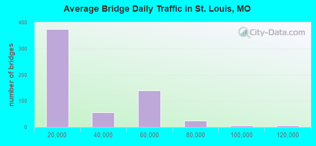
- 13,779,107Total average daily traffic
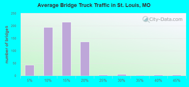
- 1,792,072Total average daily truck traffic
- National Bridge Inventory (NBI) Registered Bridges for St. Louis
- No street view available for this location
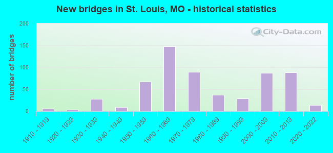
- New bridges - historical statistics
- 1Before 1900
- 11900-1909
- 61910-1919
- 31920-1929
- 281930-1939
- 91940-1949
- 671950-1959
- 1481960-1969
- 901970-1979
- 371980-1989
- 291990-1999
- 872000-2009
- 882010-2019
- 142020-2022
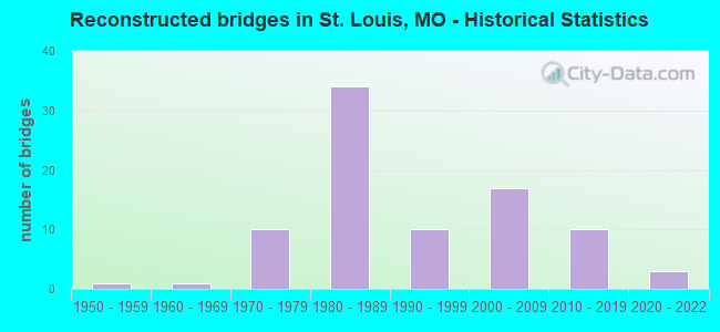
- Reconstructed bridges - Historical Statistics
- 11950-1959
- 11960-1969
- 101970-1979
- 341980-1989
- 101990-1999
- 172000-2009
- 102010-2019
- 32020-2022
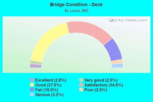
- Bridge Condition - Deck
- 2.8%Excellent
- 2.5%Very good
- 37.9%Good
- 34.8%Satisfactory
- 16.0%Fair
- 2.8%Poor
- 3.2%Serious
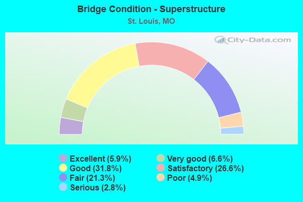
- Bridge Condition - Superstructure
- 5.9%Excellent
- 6.6%Very good
- 31.8%Good
- 26.6%Satisfactory
- 21.3%Fair
- 4.9%Poor
- 2.8%Serious
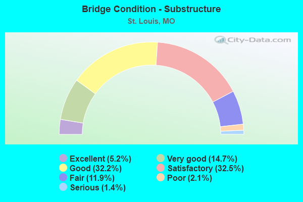
- Bridge Condition - Substructure
- 5.2%Excellent
- 14.7%Very good
- 32.2%Good
- 32.5%Satisfactory
- 11.9%Fair
- 2.1%Poor
- 1.4%Serious
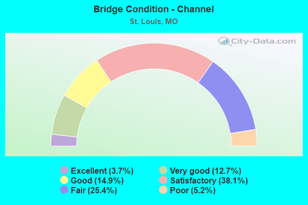
- Bridge Condition - Channel
- 3.7%Excellent
- 12.7%Very good
- 14.9%Good
- 38.1%Satisfactory
- 25.4%Fair
- 5.2%Poor
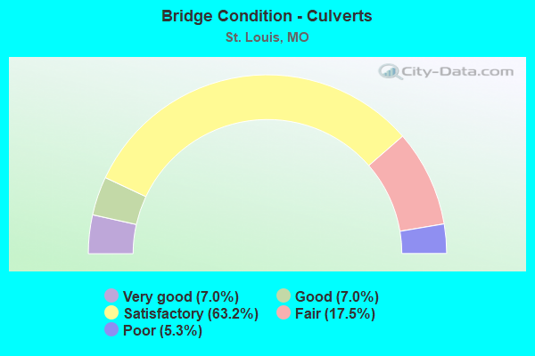
- Bridge Condition - Culverts
- 7.0%Very good
- 7.0%Good
- 63.2%Satisfactory
- 17.5%Fair
- 5.3%Poor
Find on map >> Show street view
Structure Number: 12, Location: S 11 T 45 N R 7 E (Lat: 38.652469, Lng: -90.193714), Route carried "under" structure: Interstate 70, Year Built: 1958, Structure Length: 0. m, Average Daily Traffic: 34,813 (year 2021), Truck Traffic: 18%, Features Intersected: IS 70, Facility Carried by Structure: ST LOUIS AVE E
Minimum Vertical Clearance: 4.50m (14.76ft), Kilometerpoint: 1.999, Lanes on structure: 2, Lanes under structure: 4, Material/Design: Prestressed concrete continuous, Design/Construction: Box Beam or Girders - Multiple, Length of Maximum Span: 19.1m (62.7ft)
Find on map >> Show street view
Structure Number: 12, Location: S 11 T 45 N R 7 E (Lat: 38.652469, Lng: -90.193714), Route carried "under" structure: State highway 70, Year Built: 1958, Structure Length: 0. m, Average Daily Traffic: 22,494 (year 2021), Truck Traffic: 10%, Features Intersected: RV 70, Facility Carried by Structure: ST LOUIS AVE E
Minimum Vertical Clearance: 4.88m (16.01ft), Kilometerpoint: 7.706, Lanes on structure: 2, Lanes under structure: 2, Material/Design: Prestressed concrete continuous, Design/Construction: Box Beam or Girders - Multiple, Length of Maximum Span: 19.1m (62.7ft)
Find on map >> Show street view
Structure Number: 12012, Location: S 14 T 46 N R 2 E (Lat: 38.675817, Lng: -90.206250), Route carried "under" structure: City street , Year Built: 1998, Structure Length: 0. m, Average Daily Traffic: 11,000 (year 2021), Truck Traffic: 10%, Features Intersected: CST PRAIRIE AVE, Facility Carried by Structure: IS 70 E
Minimum Vertical Clearance: 4.29m (14.07ft), Kilometerpoint: 0.000, Lanes on structure: 10, Lanes under structure: 4, Material/Design: Concrete continuous, Design/Construction: Slab, Length of Maximum Span: 18.9m (62.0ft)
Find on map >> Show street view
Structure Number: 12013, Location: S 14 T 46 N R 2 E (Lat: 38.655578, Lng: -90.195264), Route carried "under" structure: City street , Year Built: 1999, Structure Length: 0. m, Average Daily Traffic: 1,050 (year 2021), Truck Traffic: 29%, Features Intersected: CST BRANCH ST, Facility Carried by Structure: IS 70 E
Minimum Vertical Clearance: 4.83m (15.85ft), Kilometerpoint: 0.776, Lanes on structure: 8, Lanes under structure: 2, Material/Design: Concrete continuous, Design/Construction: Slab, Length of Maximum Span: 19.8m (65.0ft)
Find on map >> Show street view
Structure Number: 12016, Location: S 34 T 46 N R 7 E (Lat: 38.679597, Lng: -90.211169), Route carried "under" structure: State highway 70, Year Built: 2000, Structure Length: 0. m, Average Daily Traffic: 11,247 (year 2021), Truck Traffic: 10%, Features Intersected: RV 70, Facility Carried by Structure: RT H N
Minimum Vertical Clearance: 5.31m (17.42ft), Kilometerpoint: 4.270, Lanes on structure: 4, Lanes under structure: 2, Material/Design: Steel, Design/Construction: Stringer/Multi-beam, Length of Maximum Span: 18.0m (59.1ft)
Find on map >> Show street view
Structure Number: 12016, Location: S 34 T 46 N R 7 E (Lat: 38.679597, Lng: -90.211169), Route carried "under" structure: Interstate 70, Year Built: 2000, Structure Length: 0. m, Average Daily Traffic: 61,624 (year 2021), Truck Traffic: 18%, Features Intersected: IS 70, Facility Carried by Structure: RT H N
Minimum Vertical Clearance: 5.97m (19.59ft), Kilometerpoint: 397.074, Lanes on structure: 4, Lanes under structure: 3, Material/Design: Steel, Design/Construction: Stringer/Multi-beam, Length of Maximum Span: 18.0m (59.1ft)
Find on map >> Show street view
Structure Number: 12016, Location: S 34 T 46 N R 7 E (Lat: 38.679597, Lng: -90.211169), Route carried "under" structure: Interstate 70, Year Built: 2000, Structure Length: 0. m, Average Daily Traffic: 26,751 (year 2021), Truck Traffic: 18%, Features Intersected: IS 70, Facility Carried by Structure: RT H N
Minimum Vertical Clearance: 4.57m (14.99ft), Kilometerpoint: 5.441, Lanes on structure: 4, Lanes under structure: 3, Material/Design: Steel, Design/Construction: Stringer/Multi-beam, Length of Maximum Span: 18.0m (59.1ft)
Find on map >> Show street view
Structure Number: 12027, Location: S 24 T 46 N R 6 E (Lat: 38.700542, Lng: -90.264025), Route carried "under" structure: Interstate 70, Year Built: 2001, Structure Length: 0. m, Average Daily Traffic: 86,230 (year 2021), Truck Traffic: 18%, Features Intersected: IS 70, Facility Carried by Structure: GOODFELLOW BLVD S
Minimum Vertical Clearance: 4.95m (16.24ft), Kilometerpoint: 391.387, Lanes on structure: 8, Lanes under structure: 3, Material/Design: Steel continuous, Design/Construction: Stringer/Multi-beam, Length of Maximum Span: 32.5m (106.6ft)
Find on map >> Show street view
Structure Number: 12027, Location: S 24 T 46 N R 6 E (Lat: 38.700542, Lng: -90.264025), Route carried "under" structure: Interstate 70, Year Built: 2001, Structure Length: 0. m, Average Daily Traffic: 73,796 (year 2021), Truck Traffic: 18%, Features Intersected: IS 70, Facility Carried by Structure: GOODFELLOW BLVD S
Minimum Vertical Clearance: 4.85m (15.91ft), Kilometerpoint: 11.142, Lanes on structure: 8, Lanes under structure: 3, Material/Design: Steel continuous, Design/Construction: Stringer/Multi-beam, Length of Maximum Span: 32.5m (106.6ft)
Find on map >> Show street view
Structure Number: 12042, Location: S 32 T 46 N R 7 E (Lat: 38.686247, Lng: -90.245669), Route carried "under" structure: Interstate 70, Year Built: 2001, Structure Length: 0. m, Average Daily Traffic: 60,634 (year 2021), Truck Traffic: 18%, Features Intersected: IS 70, Facility Carried by Structure: KINGSHIGHWAY BLVD
Minimum Vertical Clearance: 4.75m (15.58ft), Kilometerpoint: 393.786, Lanes on structure: 6, Lanes under structure: 3, Material/Design: Steel continuous, Design/Construction: Stringer/Multi-beam, Length of Maximum Span: 20.4m (66.9ft)
Find on map >> Show street view
Structure Number: 12042, Location: S 32 T 46 N R 7 E (Lat: 38.686247, Lng: -90.245669), Route carried "under" structure: Interstate 70, Year Built: 2001, Structure Length: 0. m, Average Daily Traffic: 50,189 (year 2021), Truck Traffic: 18%, Features Intersected: IS 70, Facility Carried by Structure: KINGSHIGHWAY BLVD
Minimum Vertical Clearance: 4.75m (15.58ft), Kilometerpoint: 8.724, Lanes on structure: 6, Lanes under structure: 3, Material/Design: Steel continuous, Design/Construction: Stringer/Multi-beam, Length of Maximum Span: 20.4m (66.9ft)
Find on map >> Show street view
Structure Number: 12042, Location: S 32 T 46 N R 7 E (Lat: 38.686247, Lng: -90.245669), Route carried "under" structure: State highway 70, Year Built: 2001, Structure Length: 0. m, Average Daily Traffic: 22,494 (year 2021), Truck Traffic: 10%, Features Intersected: RV 70, Facility Carried by Structure: KINGSHIGHWAY BLVD
Minimum Vertical Clearance: 4.75m (15.58ft), Kilometerpoint: 0.985, Lanes on structure: 6, Lanes under structure: 2, Material/Design: Steel continuous, Design/Construction: Stringer/Multi-beam, Length of Maximum Span: 20.4m (66.9ft)
Find on map >> Show street view
Structure Number: 12043, Location: S 34 T 46 N R 7 E (Lat: 38.683917, Lng: -90.219014), Route carried "under" structure: Interstate 70, Year Built: 2001, Structure Length: 0. m, Average Daily Traffic: 27,677 (year 2021), Truck Traffic: 18%, Features Intersected: IS 70, Facility Carried by Structure: CARRIE AVE E
Minimum Vertical Clearance: 4.72m (15.49ft), Kilometerpoint: 6.294, Lanes on structure: 2, Lanes under structure: 3, Material/Design: Steel continuous, Design/Construction: Stringer/Multi-beam, Length of Maximum Span: 20.4m (66.9ft)
Find on map >> Show street view
Structure Number: 12043, Location: S 34 T 46 N R 7 E (Lat: 38.683917, Lng: -90.219014), Route carried "under" structure: Interstate 70, Year Built: 2001, Structure Length: 0. m, Average Daily Traffic: 53,463 (year 2021), Truck Traffic: 18%, Features Intersected: IS 70, Facility Carried by Structure: CARRIE AVE E
Minimum Vertical Clearance: 7.11m (23.33ft), Kilometerpoint: 396.252, Lanes on structure: 2, Lanes under structure: 3, Material/Design: Steel continuous, Design/Construction: Stringer/Multi-beam, Length of Maximum Span: 20.4m (66.9ft)
Find on map >> Show street view
Structure Number: 12043, Location: S 34 T 46 N R 7 E (Lat: 38.683917, Lng: -90.219014), Route carried "under" structure: State highway 70, Year Built: 2001, Structure Length: 0. m, Average Daily Traffic: 11,247 (year 2021), Truck Traffic: 10%, Features Intersected: RV 70, Facility Carried by Structure: CARRIE AVE E
Minimum Vertical Clearance: 5.94m (19.49ft), Kilometerpoint: 3.433, Lanes on structure: 2, Lanes under structure: 2, Material/Design: Steel continuous, Design/Construction: Stringer/Multi-beam, Length of Maximum Span: 20.4m (66.9ft)
Find on map >> Show street view
Structure Number: 12044, Location: S 33 T 46 N R 7 E (Lat: 38.683011, Lng: -90.238961), Route carried "under" structure: Interstate 70, Year Built: 2001, Structure Length: 0. m, Average Daily Traffic: 54,877 (year 2021), Truck Traffic: 18%, Features Intersected: IS 70, Facility Carried by Structure: SHREVE AVE S
Minimum Vertical Clearance: 4.70m (15.42ft), Kilometerpoint: 394.485, Lanes on structure: 2, Lanes under structure: 3, Material/Design: Steel continuous, Design/Construction: Stringer/Multi-beam, Length of Maximum Span: 18.9m (62.0ft)
Find on map >> Show street view
Structure Number: 12044, Location: S 33 T 46 N R 7 E (Lat: 38.683011, Lng: -90.238961), Route carried "under" structure: State highway 70, Year Built: 2001, Structure Length: 0. m, Average Daily Traffic: 22,494 (year 2021), Truck Traffic: 10%, Features Intersected: RV 70, Facility Carried by Structure: SHREVE AVE S
Minimum Vertical Clearance: 4.70m (15.42ft), Kilometerpoint: 1.675, Lanes on structure: 2, Lanes under structure: 2, Material/Design: Steel continuous, Design/Construction: Stringer/Multi-beam, Length of Maximum Span: 18.9m (62.0ft)
Find on map >> Show street view
Structure Number: 12044, Location: S 33 T 46 N R 7 E (Lat: 38.683011, Lng: -90.238961), Route carried "under" structure: Interstate 70, Year Built: 2001, Structure Length: 0. m, Average Daily Traffic: 52,487 (year 2021), Truck Traffic: 18%, Features Intersected: IS 70, Facility Carried by Structure: SHREVE AVE S
Minimum Vertical Clearance: 4.65m (15.26ft), Kilometerpoint: 8.044, Lanes on structure: 2, Lanes under structure: 3, Material/Design: Steel continuous, Design/Construction: Stringer/Multi-beam, Length of Maximum Span: 18.9m (62.0ft)
Find on map >> Show street view
Structure Number: 12046, Location: S 2 T 45 N R 7 E (Lat: 38.662303, Lng: -90.197411), Route carried "under" structure: Interstate 70, Year Built: 2001, Structure Length: 0. m, Average Daily Traffic: 65,699 (year 2021), Truck Traffic: 18%, Features Intersected: IS 70, Facility Carried by Structure: MC KINLEY BRG W
Minimum Vertical Clearance: 4.67m (15.32ft), Kilometerpoint: 399.369, Lanes on structure: 2, Lanes under structure: 3, Material/Design: Steel continuous, Design/Construction: Stringer/Multi-beam, Length of Maximum Span: 24.8m (81.4ft)
Find on map >> Show street view
Structure Number: 12046, Location: S 2 T 45 N R 7 E (Lat: 38.662303, Lng: -90.197411), Route carried "under" structure: Interstate 70, Year Built: 2001, Structure Length: 0. m, Average Daily Traffic: 29,523 (year 2021), Truck Traffic: 18%, Features Intersected: IS 70, Facility Carried by Structure: MC KINLEY BRG W
Minimum Vertical Clearance: 4.65m (15.26ft), Kilometerpoint: 3.153, Lanes on structure: 2, Lanes under structure: 3, Material/Design: Steel continuous, Design/Construction: Stringer/Multi-beam, Length of Maximum Span: 24.8m (81.4ft)
Find on map >> Show street view
Structure Number: 12046, Location: S 2 T 45 N R 7 E (Lat: 38.662303, Lng: -90.197411), Route carried "under" structure: State highway 70, Year Built: 2001, Structure Length: 0. m, Average Daily Traffic: 22,494 (year 2021), Truck Traffic: 10%, Features Intersected: RV 70, Facility Carried by Structure: MC KINLEY BRG W
Minimum Vertical Clearance: 4.67m (15.32ft), Kilometerpoint: 6.563, Lanes on structure: 2, Lanes under structure: 2, Material/Design: Steel continuous, Design/Construction: Stringer/Multi-beam, Length of Maximum Span: 24.8m (81.4ft)
Find on map >> Show street view
Structure Number: 12047, Location: S 2 T 45 N R 7 E (Lat: 38.661950, Lng: -90.197244), Route carried "under" structure: State highway 70, Year Built: 2001, Structure Length: 0. m, Average Daily Traffic: 11,247 (year 2021), Truck Traffic: 10%, Features Intersected: RV 70, Facility Carried by Structure: MO 115 S
Minimum Vertical Clearance: 4.83m (15.85ft), Kilometerpoint: 6.606, Lanes on structure: 4, Lanes under structure: 2, Material/Design: Steel continuous, Design/Construction: Stringer/Multi-beam, Length of Maximum Span: 21.3m (69.9ft)
Find on map >> Show street view
Structure Number: 12047, Location: S 2 T 45 N R 7 E (Lat: 38.661950, Lng: -90.197244), Route carried "under" structure: Interstate 70, Year Built: 2001, Structure Length: 0. m, Average Daily Traffic: 65,699 (year 2021), Truck Traffic: 18%, Features Intersected: IS 70, Facility Carried by Structure: MO 115 S
Minimum Vertical Clearance: 4.83m (15.85ft), Kilometerpoint: 399.401, Lanes on structure: 4, Lanes under structure: 3, Material/Design: Steel continuous, Design/Construction: Stringer/Multi-beam, Length of Maximum Span: 21.3m (69.9ft)
Find on map >> Show street view
Structure Number: 12047, Location: S 2 T 45 N R 7 E (Lat: 38.661950, Lng: -90.197244), Route carried "under" structure: Interstate 70, Year Built: 2001, Structure Length: 0. m, Average Daily Traffic: 34,813 (year 2021), Truck Traffic: 18%, Features Intersected: IS 70, Facility Carried by Structure: MO 115 S
Minimum Vertical Clearance: 4.78m (15.68ft), Kilometerpoint: 3.100, Lanes on structure: 4, Lanes under structure: 3, Material/Design: Steel continuous, Design/Construction: Stringer/Multi-beam, Length of Maximum Span: 21.3m (69.9ft)
Find on map >> Show street view
Structure Number: 12065, Location: S 34 T 46 N R 7 E (Lat: 38.683167, Lng: -90.228000), Route carried "under" structure: Interstate 70, Year Built: 2000, Structure Length: 0. m, Average Daily Traffic: 55,285 (year 2021), Truck Traffic: 18%, Features Intersected: IS 70, Facility Carried by Structure: WEST FLORISSANT AV
Minimum Vertical Clearance: 5.64m (18.50ft), Kilometerpoint: 395.499, Lanes on structure: 5, Lanes under structure: 4, Material/Design: Steel continuous, Design/Construction: Stringer/Multi-beam, Length of Maximum Span: 34.1m (111.9ft)
Find on map >> Show street view
Structure Number: 12065, Location: S 34 T 46 N R 7 E (Lat: 38.683167, Lng: -90.228000), Route carried "under" structure: Interstate 70, Year Built: 2000, Structure Length: 0. m, Average Daily Traffic: 24,013 (year 2021), Truck Traffic: 18%, Features Intersected: IS 70, Facility Carried by Structure: WEST FLORISSANT AV
Minimum Vertical Clearance: 4.75m (15.58ft), Kilometerpoint: 7.089, Lanes on structure: 5, Lanes under structure: 3, Material/Design: Steel continuous, Design/Construction: Stringer/Multi-beam, Length of Maximum Span: 34.1m (111.9ft)
Find on map >> Show street view
Structure Number: 12065, Location: S 34 T 46 N R 7 E (Lat: 38.683167, Lng: -90.228000), Route carried "under" structure: State highway 70, Year Built: 2000, Structure Length: 0. m, Average Daily Traffic: 22,494 (year 2021), Truck Traffic: 10%, Features Intersected: RV 70, Facility Carried by Structure: WEST FLORISSANT AV
Minimum Vertical Clearance: 5.33m (17.49ft), Kilometerpoint: 2.655, Lanes on structure: 5, Lanes under structure: 2, Material/Design: Steel continuous, Design/Construction: Stringer/Multi-beam, Length of Maximum Span: 34.1m (111.9ft)
Find on map >> Show street view
Structure Number: 12066, Location: S 33 T 46 N R 7 E (Lat: 38.683203, Lng: -90.225772), Route carried "under" structure: Interstate 70, Year Built: 2000, Structure Length: 0. m, Average Daily Traffic: 53,463 (year 2021), Truck Traffic: 18%, Features Intersected: IS 70, Facility Carried by Structure: TAYLOR AVE E
Minimum Vertical Clearance: 5.69m (18.67ft), Kilometerpoint: 395.632, Lanes on structure: 4, Lanes under structure: 4, Material/Design: Steel continuous, Design/Construction: Stringer/Multi-beam, Length of Maximum Span: 30.9m (101.4ft)
Find on map >> Show street view
Structure Number: 12066, Location: S 33 T 46 N R 7 E (Lat: 38.683203, Lng: -90.225772), Route carried "under" structure: Interstate 70, Year Built: 2000, Structure Length: 0. m, Average Daily Traffic: 24,013 (year 2021), Truck Traffic: 18%, Features Intersected: IS 70, Facility Carried by Structure: TAYLOR AVE E
Minimum Vertical Clearance: 4.60m (15.09ft), Kilometerpoint: 6.878, Lanes on structure: 4, Lanes under structure: 4, Material/Design: Steel continuous, Design/Construction: Stringer/Multi-beam, Length of Maximum Span: 30.9m (101.4ft)
Find on map >> Show street view
Structure Number: 12066, Location: S 33 T 46 N R 7 E (Lat: 38.683203, Lng: -90.225772), Route carried "under" structure: State highway 70, Year Built: 2000, Structure Length: 0. m, Average Daily Traffic: 11,247 (year 2021), Truck Traffic: 10%, Features Intersected: RV 70, Facility Carried by Structure: TAYLOR AVE E
Minimum Vertical Clearance: 5.66m (18.57ft), Kilometerpoint: 2.829, Lanes on structure: 4, Lanes under structure: 2, Material/Design: Steel continuous, Design/Construction: Stringer/Multi-beam, Length of Maximum Span: 30.9m (101.4ft)
Find on map >> Show street view
Structure Number: 1244, Location: S 23 T 45 N R 7 E (Lat: 38.618433, Lng: -90.184369), Route carried "under" structure: City street , Year Built: 1963, Structure Length: 0. m, Average Daily Traffic: 5,872 (year 2021), Truck Traffic: 5%, Features Intersected: CST S LENORE K SULLIVAN, Facility Carried by Structure: IS 55 S
Minimum Vertical Clearance: 14.33m (47.01ft), Kilometerpoint: 1.852, Lanes on structure: 8, Lanes under structure: 2, Material/Design: Steel continuous, Design/Construction: Box Beam or Girders - Single/Spread, Length of Maximum Span: 182.9m (600.1ft)
Find on map >> Show street view
Structure Number: 1245, Location: S 23 T 45 N R 7 E (Lat: 38.623244, Lng: -90.201456), Route carried "under" structure: Interstate 44, Year Built: 1964, Structure Length: 0. m, Average Daily Traffic: 56,554 (year 2021), Truck Traffic: 18%, Features Intersected: IS 44, Facility Carried by Structure: IS 64 E
Minimum Vertical Clearance: 5.11m (16.77ft), Kilometerpoint: 2.950, Lanes on structure: 2, Lanes under structure: 2, Material/Design: Steel continuous, Design/Construction: Girder and Floorbeam System, Length of Maximum Span: 75.6m (248.0ft)
Find on map >> Show street view
Structure Number: 1245, Location: S 23 T 45 N R 7 E (Lat: 38.623244, Lng: -90.201456), Route carried "under" structure: Interstate 44, Year Built: 1964, Structure Length: 0. m, Average Daily Traffic: 49,324 (year 2021), Truck Traffic: 18%, Features Intersected: IS 44, Facility Carried by Structure: IS 64 E
Minimum Vertical Clearance: 5.11m (16.77ft), Kilometerpoint: 468.814, Lanes on structure: 2, Lanes under structure: 2, Material/Design: Steel continuous, Design/Construction: Girder and Floorbeam System, Length of Maximum Span: 75.6m (248.0ft)
Find on map >> Show street view
Structure Number: 1245, Location: S 23 T 45 N R 7 E (Lat: 38.623244, Lng: -90.201456), Route carried "under" structure: City street , Year Built: 1964, Structure Length: 0. m, Average Daily Traffic: 12,115 (year 2021), Truck Traffic: 5%, Features Intersected: CST TUCKER BLVD, Facility Carried by Structure: IS 64 E
Minimum Vertical Clearance: 4.70m (15.42ft), Kilometerpoint: 2.121, Lanes on structure: 2, Lanes under structure: 6, Material/Design: Steel continuous, Design/Construction: Girder and Floorbeam System, Length of Maximum Span: 75.6m (248.0ft)
Find on map >> Show street view
Structure Number: 1245, Location: S 23 T 45 N R 7 E (Lat: 38.623244, Lng: -90.201456), Route carried "under" structure: City street , Year Built: 1964, Structure Length: 0. m, Average Daily Traffic: 8,565 (year 2021), Truck Traffic: 5%, Features Intersected: CST 18TH ST, Facility Carried by Structure: IS 64 E
Minimum Vertical Clearance: 4.42m (14.50ft), Kilometerpoint: 1.650, Lanes on structure: 2, Lanes under structure: 4, Material/Design: Steel continuous, Design/Construction: Girder and Floorbeam System, Length of Maximum Span: 75.6m (248.0ft)
Find on map >> Show street view
Structure Number: 1245, Location: S 23 T 45 N R 7 E (Lat: 38.623244, Lng: -90.201456), Route carried "under" structure: City street , Year Built: 1964, Structure Length: 0. m, Average Daily Traffic: 9,098 (year 2021), Truck Traffic: 5%, Features Intersected: CST 4TH ST, Facility Carried by Structure: IS 64 E
Minimum Vertical Clearance: 7.26m (23.82ft), Kilometerpoint: 0.687, Lanes on structure: 2, Lanes under structure: 5, Material/Design: Steel continuous, Design/Construction: Girder and Floorbeam System, Length of Maximum Span: 75.6m (248.0ft)
Find on map >> Show street view
Structure Number: 1245, Location: S 23 T 45 N R 7 E (Lat: 38.623244, Lng: -90.201456), Route carried "under" structure: City street , Year Built: 1964, Structure Length: 0. m, Average Daily Traffic: 10,558 (year 2021), Truck Traffic: 5%, Features Intersected: CST BROADWAY, Facility Carried by Structure: IS 64 E
Minimum Vertical Clearance: 5.08m (16.67ft), Kilometerpoint: 13.187, Lanes on structure: 2, Lanes under structure: 4, Material/Design: Steel continuous, Design/Construction: Girder and Floorbeam System, Length of Maximum Span: 75.6m (248.0ft)
Find on map >> Show street view
Structure Number: 1246, Location: S 23 T 45 N R 7 E (Lat: 38.623406, Lng: -90.201328), Route carried "under" structure: City street , Year Built: 1964, Structure Length: 0. m, Average Daily Traffic: 9,098 (year 2021), Truck Traffic: 5%, Features Intersected: CST 4TH ST, Facility Carried by Structure: IS 64 W
Minimum Vertical Clearance: 13.59m (44.59ft), Kilometerpoint: 0.703, Lanes on structure: 2, Lanes under structure: 5, Material/Design: Steel continuous, Design/Construction: Girder and Floorbeam System, Length of Maximum Span: 77.6m (254.6ft)
Find on map >> Show street view
Structure Number: 1246, Location: S 23 T 45 N R 7 E (Lat: 38.623406, Lng: -90.201328), Route carried "under" structure: Interstate 64, Year Built: 1964, Structure Length: 0. m, Average Daily Traffic: 47,399 (year 2021), Truck Traffic: 12%, Features Intersected: IS 64
Minimum Vertical Clearance: 4.55m (14.93ft), Kilometerpoint: 63.553, Lanes on structure: 2, Lanes under structure: 3, Material/Design: Steel continuous, Design/Construction: Girder and Floorbeam System, Length of Maximum Span: 77.6m (254.6ft)
Find on map >> Show street view
Structure Number: 1246, Location: S 23 T 45 N R 7 E (Lat: 38.623406, Lng: -90.201328), Route carried "under" structure: Interstate 44, Year Built: 1964, Structure Length: 0. m, Average Daily Traffic: 56,554 (year 2021), Truck Traffic: 18%, Features Intersected: IS 44, Facility Carried by Structure: IS 64 W
Minimum Vertical Clearance: 7.62m (25.00ft), Kilometerpoint: 2.937, Lanes on structure: 2, Lanes under structure: 2, Material/Design: Steel continuous, Design/Construction: Girder and Floorbeam System, Length of Maximum Span: 77.6m (254.6ft)
Find on map >> Show street view
Structure Number: 1246, Location: S 23 T 45 N R 7 E (Lat: 38.623406, Lng: -90.201328), Route carried "under" structure: City street , Year Built: 1964, Structure Length: 0. m, Average Daily Traffic: 10,558 (year 2021), Truck Traffic: 5%, Features Intersected: CST BROADWAY, Facility Carried by Structure: IS 64 W
Minimum Vertical Clearance: 11.84m (38.85ft), Kilometerpoint: 13.177, Lanes on structure: 2, Lanes under structure: 4, Material/Design: Steel continuous, Design/Construction: Girder and Floorbeam System, Length of Maximum Span: 77.6m (254.6ft)
Find on map >> Show street view
Structure Number: 1256, Location: S 23 T 45 N R 7 E (Lat: 38.622903, Lng: -90.196569), Route carried "under" structure: City street , Year Built: 1966, Structure Length: 0. m, Average Daily Traffic: 4,662 (year 2021), Truck Traffic: 5%, Features Intersected: CST SPRUCE ST, Facility Carried by Structure: RP IS64W TO CLARK
Minimum Vertical Clearance: 4.22m (13.85ft), Kilometerpoint: 0.523, Lanes on structure: 1, Lanes under structure: 2, Material/Design: Steel continuous, Design/Construction: Girder and Floorbeam System, Length of Maximum Span: 27.3m (89.6ft)
Find on map >> Show street view
Structure Number: 1257, Location: S 13 T 45 N R 7 E (Lat: 38.621972, Lng: -90.195903), Route carried "under" structure: Ramp State highway , Year Built: 1967, Structure Length: 0. m, Average Daily Traffic: 4,946 (year 2021), Truck Traffic: 18%, Features Intersected: RP IS64E TO 6TH ST, Facility Carried by Structure: RP BROADWAY TO IS6
Minimum Vertical Clearance: 4.52m (14.83ft), Kilometerpoint: 0.000, Lanes on structure: 1, Lanes under structure: 1, Material/Design: Steel continuous, Design/Construction: Girder and Floorbeam System, Length of Maximum Span: 30.5m (100.1ft)
Find on map >> Show street view
Structure Number: 1259, Location: S 23 T 45 N R 7 E (Lat: 38.622831, Lng: -90.197328), Route carried "under" structure: City street , Year Built: 1967, Structure Length: 0. m, Average Daily Traffic: 4,662 (year 2021), Truck Traffic: 5%, Features Intersected: CST SPRUCE ST, Facility Carried by Structure: RP 10TH ST TO IS64
Minimum Vertical Clearance: 4.22m (13.85ft), Kilometerpoint: 0.509, Lanes on structure: 1, Lanes under structure: 4, Material/Design: Steel continuous, Design/Construction: Girder and Floorbeam System, Length of Maximum Span: 29.3m (96.1ft)
Find on map >> Show street view
Structure Number: 1261, Location: S 23 T 45 N R 7 E (Lat: 38.624292, Lng: -90.204011), Route carried "under" structure: City street , Year Built: 1967, Structure Length: 0. m, Average Daily Traffic: 6,434 (year 2021), Truck Traffic: 8%, Features Intersected: CST 14TH ST, Facility Carried by Structure: RP 14TH ST TO IS64
Minimum Vertical Clearance: 4.55m (14.93ft), Kilometerpoint: 2.121, Lanes on structure: 1, Lanes under structure: 4, Material/Design: Concrete continuous, Design/Construction: Box Beam or Girders - Single/Spread, Length of Maximum Span: 36.0m (118.1ft)
Find on map >> Show street view
Structure Number: 1266, Location: S 27 T 45 N R 7 E (Lat: 38.611975, Lng: -90.211500), Route carried "under" structure: Interstate 44, Year Built: 1965, Structure Length: 0. m, Average Daily Traffic: 45,865 (year 2021), Truck Traffic: 12%, Features Intersected: IS 44
Minimum Vertical Clearance: 4.88m (16.01ft), Kilometerpoint: 5.280, Lanes on structure: 2, Lanes under structure: 3, Material/Design: Concrete continuous, Design/Construction: Slab, Length of Maximum Span: 18.3m (60.0ft)
Find on map >> Show street view
Structure Number: 1267, Location: S 30 T 47 N R 2 E (Lat: 38.611317, Lng: -90.209894), Route carried "under" structure: Interstate 44, Year Built: 1970, Structure Length: 0. m, Average Daily Traffic: 45,865 (year 2021), Truck Traffic: 12%, Features Intersected: IS 44, Facility Carried by Structure: RP IS55N TO TRUMAN
Minimum Vertical Clearance: 6.43m (21.10ft), Kilometerpoint: 5.121, Lanes on structure: 2, Lanes under structure: 2, Material/Design: Concrete continuous, Design/Construction: Slab, Length of Maximum Span: 20.4m (66.9ft)
Find on map >> Show street view
Structure Number: 13483, Location: S 16 T 44 N R 7 E (Lat: 38.561131, Lng: -90.242564), Route carried "under" structure: City street , Year Built: 1918, Structure Length: 0. m, Average Daily Traffic: 9,283 (year 2021), Truck Traffic: 5%, Features Intersected: CST BROADWAY ST, Facility Carried by Structure: BELLERIVE
Minimum Vertical Clearance: 4.52m (14.83ft), Kilometerpoint: 5.391, Lanes on structure: 2, Lanes under structure: 4, Material/Design: Concrete continuous, Design/Construction: Arch - Deck, Length of Maximum Span: 28.7m (94.2ft)
Find on map >> Show street view
Structure Number: 1846, Location: S 20 T 45 N R 6 E (Lat: 38.618467, Lng: -90.260122), Route carried "under" structure: City street , Year Built: 1970, Structure Length: 0. m, Average Daily Traffic: 12,478 (year 2021), Truck Traffic: 5%, Features Intersected: CST VANDEVENTER AVE, Facility Carried by Structure: IS 44 E
Minimum Vertical Clearance: 5.79m (19.00ft), Kilometerpoint: 6.613, Lanes on structure: 4, Lanes under structure: 5, Material/Design: Steel continuous, Design/Construction: Stringer/Multi-beam, Length of Maximum Span: 29.1m (95.5ft)
Find on map >> Show street view
Structure Number: 1847, Location: S 20 T 45 N R 6 E (Lat: 38.618622, Lng: -90.259958), Route carried "under" structure: City street , Year Built: 1970, Structure Length: 0. m, Average Daily Traffic: 11,375 (year 2021), Truck Traffic: 5%, Features Intersected: CST VANDEVENTER AVE, Facility Carried by Structure: IS 44 W
Minimum Vertical Clearance: 5.74m (18.83ft), Kilometerpoint: 6.589, Lanes on structure: 4, Lanes under structure: 5, Material/Design: Steel continuous, Design/Construction: Stringer/Multi-beam, Length of Maximum Span: 29.1m (95.5ft)
Find on map >> Show street view
Structure Number: 1848, Location: S 20 T 45 N R 7 E (Lat: 38.618111, Lng: -90.256078), Route carried "under" structure: City street , Year Built: 1970, Structure Length: 0. m, Average Daily Traffic: 6,812 (year 2021), Truck Traffic: 5%, Features Intersected: CST TOWER GROVE AVE, Facility Carried by Structure: IS 44 E
Minimum Vertical Clearance: 4.32m (14.17ft), Kilometerpoint: 1.751, Lanes on structure: 5, Lanes under structure: 2, Material/Design: Concrete continuous, Design/Construction: Slab, Length of Maximum Span: 15.1m (49.5ft)
Find on map >> Show street view
Structure Number: 1849, Location: S 20 T 45 N R 7 E (Lat: 38.618308, Lng: -90.256047), Route carried "under" structure: City street , Year Built: 1970, Structure Length: 0. m, Average Daily Traffic: 6,812 (year 2021), Truck Traffic: 5%, Features Intersected: CST TOWER GROVE AVE, Facility Carried by Structure: IS 44 W
Minimum Vertical Clearance: 4.34m (14.24ft), Kilometerpoint: 1.727, Lanes on structure: 5, Lanes under structure: 2, Material/Design: Concrete continuous, Design/Construction: Slab, Length of Maximum Span: 15.1m (49.5ft)
Find on map >> Show street view
Structure Number: 1937, Location: S 28 T 45 N R 7 E (Lat: 38.615222, Lng: -90.232617), Route carried "under" structure: Interstate 44, Year Built: 1970, Structure Length: 0. m, Average Daily Traffic: 44,418 (year 2021), Truck Traffic: 12%, Features Intersected: IS 44, Facility Carried by Structure: COMPTON AVE S
Minimum Vertical Clearance: 4.78m (15.68ft), Kilometerpoint: 464.527, Lanes on structure: 2, Lanes under structure: 4, Material/Design: Steel continuous, Design/Construction: Stringer/Multi-beam, Length of Maximum Span: 30.8m (101.0ft)
Find on map >> Show street view
Structure Number: 1937, Location: S 28 T 45 N R 7 E (Lat: 38.615222, Lng: -90.232617), Route carried "under" structure: Interstate 44, Year Built: 1970, Structure Length: 0. m, Average Daily Traffic: 43,426 (year 2021), Truck Traffic: 12%, Features Intersected: IS 44, Facility Carried by Structure: COMPTON AVE S
Minimum Vertical Clearance: 4.57m (14.99ft), Kilometerpoint: 7.165, Lanes on structure: 2, Lanes under structure: 5, Material/Design: Steel continuous, Design/Construction: Stringer/Multi-beam, Length of Maximum Span: 30.8m (101.0ft)
Find on map >> Show street view
Structure Number: 1938, Location: S 28 T 45 N R 7 E (Lat: 38.614292, Lng: -90.228111), Route carried "under" structure: Interstate 44, Year Built: 1970, Structure Length: 0. m, Average Daily Traffic: 43,426 (year 2021), Truck Traffic: 12%, Features Intersected: IS 44, Facility Carried by Structure: NEBRASKA AVE S
Minimum Vertical Clearance: 4.57m (14.99ft), Kilometerpoint: 6.759, Lanes on structure: 2, Lanes under structure: 4, Material/Design: Concrete continuous, Design/Construction: Box Beam or Girders - Single/Spread, Length of Maximum Span: 22.6m (74.1ft)
Find on map >> Show street view
Structure Number: 1938, Location: S 28 T 45 N R 7 E (Lat: 38.614292, Lng: -90.228111), Route carried "under" structure: Interstate 44, Year Built: 1970, Structure Length: 0. m, Average Daily Traffic: 44,418 (year 2021), Truck Traffic: 12%, Features Intersected: IS 44, Facility Carried by Structure: NEBRASKA AVE S
Minimum Vertical Clearance: 4.75m (15.58ft), Kilometerpoint: 464.932, Lanes on structure: 2, Lanes under structure: 4, Material/Design: Concrete continuous, Design/Construction: Box Beam or Girders - Single/Spread, Length of Maximum Span: 22.6m (74.1ft)
Find on map >> Show street view
Structure Number: 199, Location: S 26 T 45 N R 6 E (Lat: 38.608536, Lng: -90.304256), Route carried "under" structure: Interstate 44, Year Built: 1971, Structure Length: 0. m, Average Daily Traffic: 41,918 (year 2021), Truck Traffic: 12%, Features Intersected: IS 44, Facility Carried by Structure: ARSENAL ST E
Minimum Vertical Clearance: 4.67m (15.32ft), Kilometerpoint: 457.758, Lanes on structure: 4, Lanes under structure: 4, Material/Design: Steel continuous, Design/Construction: Stringer/Multi-beam, Length of Maximum Span: 24.1m (79.1ft)
Find on map >> Show street view
Structure Number: 199, Location: S 26 T 45 N R 6 E (Lat: 38.608536, Lng: -90.304256), Route carried "under" structure: Interstate 44, Year Built: 1971, Structure Length: 0. m, Average Daily Traffic: 44,212 (year 2021), Truck Traffic: 12%, Features Intersected: IS 44, Facility Carried by Structure: ARSENAL ST E
Minimum Vertical Clearance: 5.08m (16.67ft), Kilometerpoint: 13.963, Lanes on structure: 4, Lanes under structure: 4, Material/Design: Steel continuous, Design/Construction: Stringer/Multi-beam, Length of Maximum Span: 24.1m (79.1ft)
Find on map >> Show street view
Structure Number: 2, Location: S 26 T 45 N R 6 E (Lat: 38.605900, Lng: -90.307306), Route carried "under" structure: Interstate 44, Year Built: 1971, Structure Length: 0. m, Average Daily Traffic: 41,918 (year 2021), Truck Traffic: 12%, Features Intersected: IS 44, Facility Carried by Structure: JAMIESON AVE S
Minimum Vertical Clearance: 4.60m (15.09ft), Kilometerpoint: 457.344, Lanes on structure: 3, Lanes under structure: 4, Material/Design: Steel continuous, Design/Construction: Stringer/Multi-beam, Length of Maximum Span: 34.4m (112.9ft)
Find on map >> Show street view
Structure Number: 2, Location: S 26 T 45 N R 6 E (Lat: 38.605900, Lng: -90.307306), Route carried "under" structure: Interstate 44, Year Built: 1971, Structure Length: 0. m, Average Daily Traffic: 44,212 (year 2021), Truck Traffic: 12%, Features Intersected: IS 44, Facility Carried by Structure: JAMIESON AVE S
Minimum Vertical Clearance: 4.79m (15.72ft), Kilometerpoint: 14.334, Lanes on structure: 3, Lanes under structure: 4, Material/Design: Steel continuous, Design/Construction: Stringer/Multi-beam, Length of Maximum Span: 34.4m (112.9ft)
Find on map >> Show street view
Structure Number: 2001, Location: S 26 T 45 N R 6 E (Lat: 38.606011, Lng: -90.307164), Route carried "under" structure: Interstate 44, Year Built: 1971, Structure Length: 0. m, Average Daily Traffic: 41,918 (year 2021), Truck Traffic: 12%, Features Intersected: IS 44, Facility Carried by Structure: JAMIESON AVE N
Minimum Vertical Clearance: 4.79m (15.72ft), Kilometerpoint: 457.344, Lanes on structure: 3, Lanes under structure: 4, Material/Design: Steel continuous, Design/Construction: Stringer/Multi-beam, Length of Maximum Span: 34.4m (112.9ft)
Find on map >> Show street view
Structure Number: 2001, Location: S 26 T 45 N R 6 E (Lat: 38.606011, Lng: -90.307164), Route carried "under" structure: Interstate 44, Year Built: 1971, Structure Length: 0. m, Average Daily Traffic: 44,212 (year 2021), Truck Traffic: 12%, Features Intersected: IS 44, Facility Carried by Structure: JAMIESON AVE N
Minimum Vertical Clearance: 4.67m (15.32ft), Kilometerpoint: 14.334, Lanes on structure: 3, Lanes under structure: 4, Material/Design: Steel continuous, Design/Construction: Stringer/Multi-beam, Length of Maximum Span: 34.4m (112.9ft)
Find on map >> Show street view
Structure Number: 2002, Location: S 25 T 45 N R 6 E (Lat: 38.613275, Lng: -90.301200), Route carried "under" structure: City street , Year Built: 1971, Structure Length: 0. m, Average Daily Traffic: 8,528 (year 2021), Truck Traffic: 5%, Features Intersected: CST SOUTHWEST AVE, Facility Carried by Structure: IS 44 E
Minimum Vertical Clearance: 4.39m (14.40ft), Kilometerpoint: 1.305, Lanes on structure: 5, Lanes under structure: 2, Material/Design: Concrete continuous, Design/Construction: Slab, Length of Maximum Span: 20.4m (66.9ft)
Find on map >> Show street view
Structure Number: 2003, Location: S 25 T 45 N R 6 E (Lat: 38.613400, Lng: -90.301417), Route carried "under" structure: City street , Year Built: 1971, Structure Length: 0. m, Average Daily Traffic: 8,528 (year 2021), Truck Traffic: 5%, Features Intersected: CST SOUTHWEST AVE, Facility Carried by Structure: IS 44 W
Minimum Vertical Clearance: 4.39m (14.40ft), Kilometerpoint: 1.283, Lanes on structure: 4, Lanes under structure: 2, Material/Design: Concrete continuous, Design/Construction: Slab, Length of Maximum Span: 20.4m (66.9ft)
Find on map >> Show street view
Structure Number: 2004, Location: S 19 T 45 N R 7 E (Lat: 38.619153, Lng: -90.276672), Route carried "under" structure: Interstate 44, Year Built: 1969, Structure Length: 0. m, Average Daily Traffic: 41,506 (year 2021), Truck Traffic: 12%, Features Intersected: IS 44, Facility Carried by Structure: MACKLIND AVE S
Minimum Vertical Clearance: 4.62m (15.16ft), Kilometerpoint: 460.642, Lanes on structure: 2, Lanes under structure: 4, Material/Design: Concrete continuous, Design/Construction: Slab, Length of Maximum Span: 22.6m (74.1ft)
Find on map >> Show street view
Structure Number: 2004, Location: S 19 T 45 N R 7 E (Lat: 38.619153, Lng: -90.276672), Route carried "under" structure: Interstate 44, Year Built: 1969, Structure Length: 0. m, Average Daily Traffic: 44,823 (year 2021), Truck Traffic: 12%, Features Intersected: IS 44, Facility Carried by Structure: MACKLIND AVE S
Minimum Vertical Clearance: 4.78m (15.68ft), Kilometerpoint: 11.048, Lanes on structure: 2, Lanes under structure: 4, Material/Design: Concrete continuous, Design/Construction: Slab, Length of Maximum Span: 22.6m (74.1ft)
Find on map >> Show street view
Structure Number: 2006, Location: S 19 T 45 N R 7 E (Lat: 38.619122, Lng: -90.280989), Route carried "under" structure: City street , Year Built: 1969, Structure Length: 0. m, Average Daily Traffic: 658 (year 2021), Truck Traffic: 5%, Features Intersected: CST SUBLETTE AVE, Facility Carried by Structure: IS 44 E
Minimum Vertical Clearance: 5.08m (16.67ft), Kilometerpoint: 0.478, Lanes on structure: 5, Lanes under structure: 2, Material/Design: Concrete continuous, Design/Construction: Slab, Length of Maximum Span: 16.8m (55.1ft)
Find on map >> Show street view
Structure Number: 2007, Location: S 19 T 45 N R 7 E (Lat: 38.619314, Lng: -90.280947), Route carried "under" structure: City street , Year Built: 1969, Structure Length: 0. m, Average Daily Traffic: 658 (year 2021), Truck Traffic: 5%, Features Intersected: CST SUBLETTE AVE, Facility Carried by Structure: IS 44 W
Minimum Vertical Clearance: 5.18m (16.99ft), Kilometerpoint: 0.459, Lanes on structure: 4, Lanes under structure: 2, Material/Design: Concrete continuous, Design/Construction: Slab, Length of Maximum Span: 16.8m (55.1ft)
Find on map >> Show street view
Structure Number: 2041, Location: S 24 T 45 N R 6 E (Lat: 38.618578, Lng: -90.288156), Route carried "under" structure: City street , Year Built: 1969, Structure Length: 0. m, Average Daily Traffic: 33,778 (year 2021), Truck Traffic: 5%, Features Intersected: CST HAMPTON AVE, Facility Carried by Structure: IS 44 E
Minimum Vertical Clearance: 4.62m (15.16ft), Kilometerpoint: 1.598, Lanes on structure: 4, Lanes under structure: 8, Material/Design: Steel continuous, Design/Construction: Stringer/Multi-beam, Length of Maximum Span: 28.3m (92.8ft)
Find on map >> Show street view
Structure Number: 2042, Location: S 24 T 45 N R 6 E (Lat: 38.618736, Lng: -90.288233), Route carried "under" structure: City street , Year Built: 1969, Structure Length: 0. m, Average Daily Traffic: 36,108 (year 2021), Truck Traffic: 5%, Features Intersected: CST HAMPTON AVE, Facility Carried by Structure: IS 44 W
Minimum Vertical Clearance: 4.62m (15.16ft), Kilometerpoint: 1.577, Lanes on structure: 4, Lanes under structure: 8, Material/Design: Steel continuous, Design/Construction: Stringer/Multi-beam, Length of Maximum Span: 28.3m (92.8ft)
Find on map >> Show street view
Structure Number: 2065, Location: S 35 T 45 N R 6 E (Lat: 38.599622, Lng: -90.315972), Route carried "under" structure: City street , Year Built: 1971, Structure Length: 0. m, Average Daily Traffic: 14,518 (year 2021), Truck Traffic: 5%, Features Intersected: CST WABASH AVE, Facility Carried by Structure: IS 44 E
Minimum Vertical Clearance: 4.60m (15.09ft), Kilometerpoint: 0.024, Lanes on structure: 4, Lanes under structure: 4, Material/Design: Steel continuous, Design/Construction: Stringer/Multi-beam, Length of Maximum Span: 36.3m (119.1ft)
Find on map >> Show street view
Structure Number: 2066, Location: S 35 T 45 N R 6 E (Lat: 38.599847, Lng: -90.315939), Route carried "under" structure: City street , Year Built: 1971, Structure Length: 0. m, Average Daily Traffic: 11,406 (year 2021), Truck Traffic: 5%, Features Intersected: CST ELLENDALE AVE, Facility Carried by Structure: IS 44 W
Minimum Vertical Clearance: 4.60m (15.09ft), Kilometerpoint: 1.080, Lanes on structure: 4, Lanes under structure: 4, Material/Design: Steel continuous, Design/Construction: Stringer/Multi-beam, Length of Maximum Span: 35.1m (115.2ft)
Find on map >> Show street view
Structure Number: 2685, Location: S 26 T 45 N R 7 E (Lat: 38.611347, Lng: -90.203786), Route carried "under" structure: Interstate 44, Year Built: 1978, Structure Length: 0. m, Average Daily Traffic: 54,580 (year 2021), Truck Traffic: 18%, Features Intersected: IS 44, Facility Carried by Structure: LAFAYETTE AVE E
Minimum Vertical Clearance: 4.88m (16.01ft), Kilometerpoint: 467.195, Lanes on structure: 2, Lanes under structure: 5, Material/Design: Steel continuous, Design/Construction: Stringer/Multi-beam, Length of Maximum Span: 29.0m (95.1ft)
Find on map >> Show street view
Structure Number: 2685, Location: S 26 T 45 N R 7 E (Lat: 38.611347, Lng: -90.203786), Route carried "under" structure: Interstate 44, Year Built: 1978, Structure Length: 0. m, Average Daily Traffic: 56,368 (year 2021), Truck Traffic: 18%, Features Intersected: IS 44, Facility Carried by Structure: LAFAYETTE AVE E
Minimum Vertical Clearance: 5.08m (16.67ft), Kilometerpoint: 4.569, Lanes on structure: 2, Lanes under structure: 5, Material/Design: Steel continuous, Design/Construction: Stringer/Multi-beam, Length of Maximum Span: 29.0m (95.1ft)
Find on map >> Show street view
Structure Number: 2761, Location: S 19 T 45 N R 7 E (Lat: 38.619058, Lng: -90.275067), Route carried "under" structure: Interstate 44, Year Built: 1972, Structure Length: 0. m, Average Daily Traffic: 44,823 (year 2021), Truck Traffic: 12%, Features Intersected: IS 44, Facility Carried by Structure: EDWARDS ST S
Minimum Vertical Clearance: 4.78m (15.68ft), Kilometerpoint: 10.908, Lanes on structure: 2, Lanes under structure: 4, Material/Design: Concrete continuous, Design/Construction: Slab, Length of Maximum Span: 21.6m (70.9ft)
Find on map >> Show street view
Structure Number: 2761, Location: S 19 T 45 N R 7 E (Lat: 38.619058, Lng: -90.275067), Route carried "under" structure: Interstate 44, Year Built: 1972, Structure Length: 0. m, Average Daily Traffic: 41,506 (year 2021), Truck Traffic: 12%, Features Intersected: IS 44, Facility Carried by Structure: EDWARDS ST S
Minimum Vertical Clearance: 4.70m (15.42ft), Kilometerpoint: 460.783, Lanes on structure: 2, Lanes under structure: 4, Material/Design: Concrete continuous, Design/Construction: Slab, Length of Maximum Span: 21.6m (70.9ft)
Find on map >> Show street view
Structure Number: 2826, Location: S 25 T 45 N R 7 E (Lat: 38.613131, Lng: -90.198567), Route carried "under" structure: Ramp State highway , Year Built: 1978, Structure Length: 0. m, Average Daily Traffic: 4,425 (year 2021), Truck Traffic: 7%, Features Intersected: RP IS44E TO PARK AVE, Facility Carried by Structure: RP 8TH ST TO IS44E
Minimum Vertical Clearance: 5.00m (16.40ft), Kilometerpoint: 0.188, Lanes on structure: 1, Lanes under structure: 1, Material/Design: Steel continuous, Design/Construction: Stringer/Multi-beam, Length of Maximum Span: 24.7m (81.0ft)
Find on map >> Show street view
Structure Number: 2826, Location: S 25 T 45 N R 7 E (Lat: 38.613131, Lng: -90.198567), Route carried "under" structure: City street , Year Built: 1978, Structure Length: 0. m, Average Daily Traffic: 4,542 (year 2021), Truck Traffic: 5%, Features Intersected: CST PARK AVE, Facility Carried by Structure: RP 8TH ST TO IS44E
Minimum Vertical Clearance: 5.64m (18.50ft), Kilometerpoint: 3.595, Lanes on structure: 1, Lanes under structure: 4, Material/Design: Steel continuous, Design/Construction: Stringer/Multi-beam, Length of Maximum Span: 24.7m (81.0ft)
Find on map >> Show street view
Structure Number: 2828, Location: S 25 T 45 N R 7 E (Lat: 38.615128, Lng: -90.194586), Route carried "under" structure: City street , Year Built: 1977, Structure Length: 0. m, Average Daily Traffic: 6,286 (year 2021), Truck Traffic: 10%, Features Intersected: CST BROADWAY, Facility Carried by Structure: RP IS44W TO S 7TH
Minimum Vertical Clearance: 4.73m (15.52ft), Kilometerpoint: 13.881, Lanes on structure: 1, Lanes under structure: 4, Material/Design: Steel continuous, Design/Construction: Stringer/Multi-beam, Length of Maximum Span: 25.1m (82.3ft)
Find on map >> Show street view
Structure Number: 2828, Location: S 25 T 45 N R 7 E (Lat: 38.615128, Lng: -90.194586), Route carried "under" structure: City street , Year Built: 1977, Structure Length: 0. m, Average Daily Traffic: 234 (year 2021), Truck Traffic: 4%, Features Intersected: CST HICKORY ST, Facility Carried by Structure: RP IS44W TO S 7TH
Minimum Vertical Clearance: 4.88m (16.01ft), Kilometerpoint: 0.288, Lanes on structure: 1, Lanes under structure: 2, Material/Design: Steel continuous, Design/Construction: Stringer/Multi-beam, Length of Maximum Span: 25.1m (82.3ft)
Find on map >> Show street view
Structure Number: 29319, Location: S 656 T 46 N R 6 E (Lat: 38.735806, Lng: -90.353811), Route carried "under" structure: City street , Year Built: 1998, Structure Length: 0. m, Average Daily Traffic: 10,000 (year 2020), Truck Traffic: 5%, Features Intersected: PARKING LOT ACCESS, Facility Carried by Structure: E TERMINAL DR
Minimum Vertical Clearance: 4.44m (14.57ft), Kilometerpoint: 0.000, Lanes on structure: 2, Lanes under structure: 1, Material/Design: Prestressed concrete continuous, Design/Construction: Stringer/Multi-beam, Length of Maximum Span: 24.0m (78.7ft)
Find on map >> Show street view
Structure Number: 29534, Location: S 17 T 45 N R 7 E (Lat: 38.630208, Lng: -90.249475), Route carried "under" structure: Ramp State highway , Year Built: 2003, Structure Length: 0. m, Average Daily Traffic: 6,048 (year 2021), Truck Traffic: 18%, Features Intersected: RP VANDEVENTER AVE TO IS, Facility Carried by Structure: N SARAH ST S
Minimum Vertical Clearance: 4.67m (15.32ft), Kilometerpoint: 0.303, Lanes on structure: 2, Lanes under structure: 1, Material/Design: Concrete continuous, Design/Construction: Slab, Length of Maximum Span: 14.6m (47.9ft)
Find on map >> Show street view
Structure Number: 3004, Location: S 16 T 45 N R 7 E (Lat: 38.632122, Lng: -90.237933), Route carried "under" structure: Interstate 64, Year Built: 1982, Structure Length: 0. m, Average Daily Traffic: 55,174 (year 2021), Truck Traffic: 12%, Features Intersected: IS 64
Minimum Vertical Clearance: 4.98m (16.34ft), Kilometerpoint: 60.336, Lanes on structure: 3, Lanes under structure: 4, Material/Design: Steel continuous, Design/Construction: Stringer/Multi-beam, Length of Maximum Span: 36.9m (121.1ft)
Find on map >> Show street view
Structure Number: 3004, Location: S 16 T 45 N R 7 E (Lat: 38.632122, Lng: -90.237933), Route carried "under" structure: City street , Year Built: 1982, Structure Length: 0. m, Average Daily Traffic: 7,348 (year 2021), Truck Traffic: 5%, Features Intersected: CST GRAND BLVD, Facility Carried by Structure: IS 64 W
Minimum Vertical Clearance: 5.08m (16.67ft), Kilometerpoint: 13.601, Lanes on structure: 3, Lanes under structure: 6, Material/Design: Steel continuous, Design/Construction: Stringer/Multi-beam, Length of Maximum Span: 36.9m (121.1ft)
Find on map >> Show street view
Structure Number: 3004, Location: S 16 T 45 N R 7 E (Lat: 38.632122, Lng: -90.237933), Route carried "under" structure: City street , Year Built: 1982, Structure Length: 0. m, Average Daily Traffic: 19,987 (year 2021), Truck Traffic: 5%, Features Intersected: CST VANDEVENTER AVE, Facility Carried by Structure: IS 64 W
Minimum Vertical Clearance: 12.12m (39.76ft), Kilometerpoint: 4.466, Lanes on structure: 3, Lanes under structure: 4, Material/Design: Steel continuous, Design/Construction: Stringer/Multi-beam, Length of Maximum Span: 36.9m (121.1ft)
Find on map >> Show street view
Structure Number: 3004, Location: S 16 T 45 N R 7 E (Lat: 38.632122, Lng: -90.237933), Route carried "under" structure: City street , Year Built: 1982, Structure Length: 0. m, Average Daily Traffic: 6,811 (year 2021), Truck Traffic: 10%, Features Intersected: CST CLAYTON AVE, Facility Carried by Structure: IS 64 W
Minimum Vertical Clearance: 5.49m (18.01ft), Kilometerpoint: 2.781, Lanes on structure: 3, Lanes under structure: 2, Material/Design: Steel continuous, Design/Construction: Stringer/Multi-beam, Length of Maximum Span: 36.9m (121.1ft)
Find on map >> Show street view
Structure Number: 3004, Location: S 16 T 45 N R 7 E (Lat: 38.632122, Lng: -90.237933), Route carried "under" structure: City street , Year Built: 1982, Structure Length: 0. m, Average Daily Traffic: 5,013 (year 2021), Truck Traffic: 5%, Features Intersected: CST MARKET ST, Facility Carried by Structure: IS 64 W
Minimum Vertical Clearance: 5.46m (17.91ft), Kilometerpoint: 0.267, Lanes on structure: 3, Lanes under structure: 1, Material/Design: Steel continuous, Design/Construction: Stringer/Multi-beam, Length of Maximum Span: 36.9m (121.1ft)
Find on map >> Show street view
Structure Number: 303, Location: S 22 T 45 N R 7 E (Lat: 38.631397, Lng: -90.229961), Route carried "under" structure: City street , Year Built: 1981, Structure Length: 0. m, Average Daily Traffic: 8,817 (year 2021), Truck Traffic: 5%, Features Intersected: CST FOREST PARK AVE, Facility Carried by Structure: RP MARKET ST TO IS
Minimum Vertical Clearance: 5.49m (18.01ft), Kilometerpoint: 3.272, Lanes on structure: 1, Lanes under structure: 2, Material/Design: Prestressed concrete continuous, Design/Construction: Stringer/Multi-beam, Length of Maximum Span: 16.0m (52.5ft)
Find on map >> Show street view
Structure Number: 304, Location: S 17 T 45 N R 7 E (Lat: 38.631303, Lng: -90.249028), Route carried "under" structure: City street , Year Built: 1981, Structure Length: 0. m, Average Daily Traffic: 2,265 (year 2021), Truck Traffic: 5%, Features Intersected: CST N SARAH ST, Facility Carried by Structure: IS 64 W
Minimum Vertical Clearance: 4.80m (15.75ft), Kilometerpoint: 0.502, Lanes on structure: 3, Lanes under structure: 2, Material/Design: Prestressed concrete continuous, Design/Construction: Stringer/Multi-beam, Length of Maximum Span: 18.3m (60.0ft)
Find on map >> Show street view
Structure Number: 30667, Location: S 35 T 46 N R 7 E (Lat: 38.681028, Lng: -90.208436), Route carried "under" structure: State highway H, Year Built: 1975, Structure Length: 0. m, Average Daily Traffic: 14,618 (year 2021), Truck Traffic: 5%, Features Intersected: RT H
Minimum Vertical Clearance: 4.37m (14.34ft), Kilometerpoint: 0.082, Lanes on structure: 4, Lanes under structure: 2, Material/Design: Steel continuous, Design/Construction: Stringer/Multi-beam, Length of Maximum Span: 32.0m (105.0ft)
Find on map >> Show street view
Structure Number: 30667, Location: S 35 T 46 N R 7 E (Lat: 38.681028, Lng: -90.208436), Route carried "under" structure: City street , Year Built: 1975, Structure Length: 0. m, Average Daily Traffic: 3,773 (year 2021), Truck Traffic: 14%, Features Intersected: CST BROADWAY, Facility Carried by Structure: RT H N
Minimum Vertical Clearance: 4.57m (14.99ft), Kilometerpoint: 5.976, Lanes on structure: 4, Lanes under structure: 2, Material/Design: Steel continuous, Design/Construction: Stringer/Multi-beam, Length of Maximum Span: 32.0m (105.0ft)