Bridge Statistics for St. Louis, Missouri (MO)
Condition, Traffic, Stress, Structural Evaluation, Project Costs
- National Bridge Inventory (NBI) Statistics
- 608Number of bridges
- 12,736ft / 3,882mTotal length
- $695,294,000Total costs
- 13,779,107Total average daily traffic
- 1,792,072Total average daily truck traffic
- National Bridge Inventory (NBI) Registered Bridges for St. Louis
- No street view available for this location
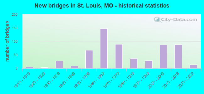
- New bridges - historical statistics
- 1Before 1900
- 11900-1909
- 61910-1919
- 31920-1929
- 281930-1939
- 91940-1949
- 671950-1959
- 1481960-1969
- 901970-1979
- 371980-1989
- 291990-1999
- 872000-2009
- 882010-2019
- 142020-2022
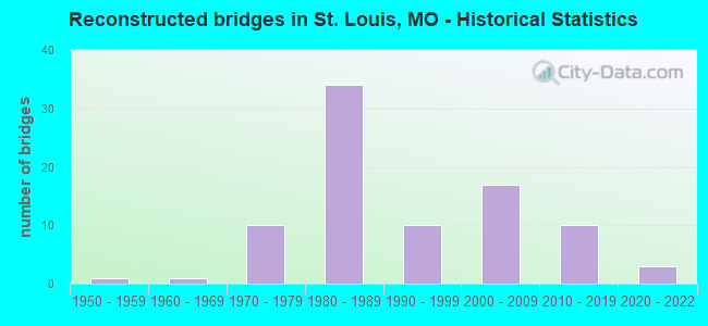
- Reconstructed bridges - Historical Statistics
- 11950-1959
- 11960-1969
- 101970-1979
- 341980-1989
- 101990-1999
- 172000-2009
- 102010-2019
- 32020-2022
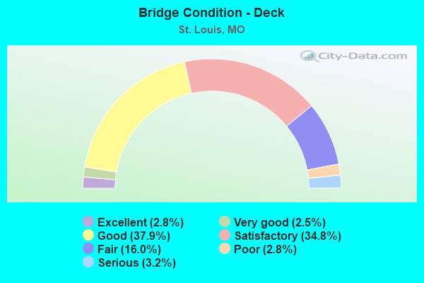
- Bridge Condition - Deck
- 2.8%Excellent
- 2.5%Very good
- 37.9%Good
- 34.8%Satisfactory
- 16.0%Fair
- 2.8%Poor
- 3.2%Serious
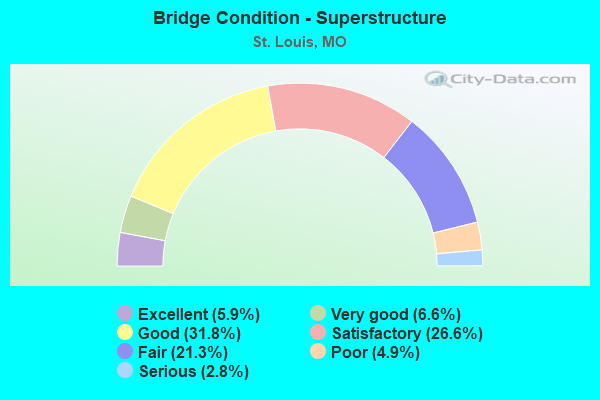
- Bridge Condition - Superstructure
- 5.9%Excellent
- 6.6%Very good
- 31.8%Good
- 26.6%Satisfactory
- 21.3%Fair
- 4.9%Poor
- 2.8%Serious
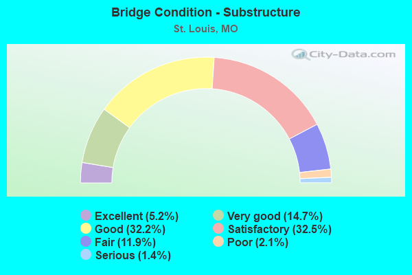
- Bridge Condition - Substructure
- 5.2%Excellent
- 14.7%Very good
- 32.2%Good
- 32.5%Satisfactory
- 11.9%Fair
- 2.1%Poor
- 1.4%Serious
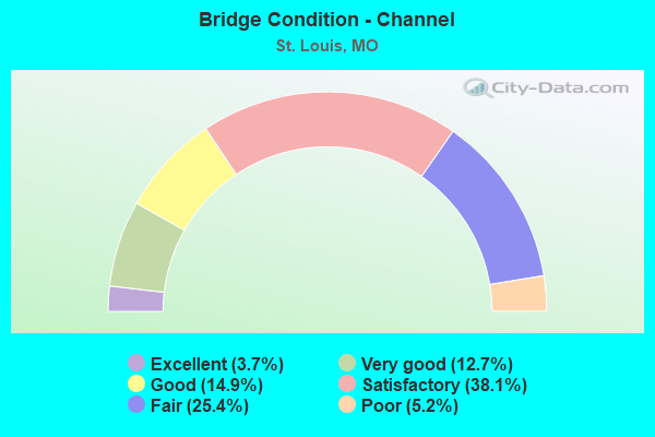
- Bridge Condition - Channel
- 3.7%Excellent
- 12.7%Very good
- 14.9%Good
- 38.1%Satisfactory
- 25.4%Fair
- 5.2%Poor
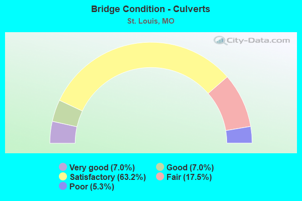
- Bridge Condition - Culverts
- 7.0%Very good
- 7.0%Good
- 63.2%Satisfactory
- 17.5%Fair
- 5.3%Poor
Find on map >> Show street view
Structure Number: 893, Location: S 27 T 45 N R 7 E (Lat: 38.610072, Lng: -90.209878), Route carried "on" structure: Interstate 44, Year Built: 1965, Year Reconstructed: 1990, Status: Open, Structure Length: 22.34m (73.29ft), Average Daily Traffic: 44,506 (year 2021), Truck Traffic: 12%, Average Future Daily Traffic: 55,633 (year 2041), Design Load: HS 20+Mod, Features Intersected: IS 55, CST 12TH ST, IS
Minimum Vertical Clearance: 30+ m (98+ ft), Kilometerpoint: 466.529, Lanes on structure: 2, Lanes under structure: 13, Base Highway Network: Yes, Owner: State Highway Agency, Approaching Roadway Width: 9.2m (30.2ft), Material/Design: Concrete continuous, Design/Construction: Box Beam or Girders - Single/Spread, Number Of Spans In Main Unit: 10, Length of Maximum Span: 28.9m (94.8ft), Curb-To-Curb Width: 9.2m (30.2ft), Out-to-Out Width: 10.0m (32.8ft)
Condition: Deck: Satisfactory, Superstructure: Satisfactory, Substructure: Satisfactory, Operating Rating: 63.9 metric tons, Method Used To Determine Operating Rating: Load Factor (LF), Inventory Rating: 38.7 metric tons, Method Used To Determine Inventory Rating: Load Factor (LF), Structural Evaluation: Equal to present minimum criteria, Deck Geometry: Meets minimum limits, Underclear: High priority of corrective action, Approach Roadway Alignment: Equal to present desirable criteria, Length Of Structure Improvement: 2.24m (7.35ft), Designated Inspection Frequency: Every 24 months, Other Special Inspection Frequency: Every 24 months, Inspection Date: September 2020, Other Special Inspection Date: September 2020, Bridge Improvement Cost: $1,829,000, Roadway Improvement Cost: $183,000, Total Project Cost: $2,743,000 ( Estimate for 2022), Deck Structure Type: Concrete Cast-file-Place, Wearing Surface/Protective System: Wearing Surface: Latex Concrete, Membrane: Built-up, Deck Protection: Epoxy Coated Reinforcing
Find on map >> Show street view
Structure Number: 895, Location: S 27 T 45 N R 7 E (Lat: 38.612244, Lng: -90.214500), Route carried "on" structure: City street , Year Built: 1970, Year Reconstructed: 2007, Status: Posted for load, Structure Length: 9.33m (30.61ft), Average Daily Traffic: 5,652 (year 2021), Truck Traffic: 5%, Average Future Daily Traffic: 8,478 (year 2041), Design Load: HS 20+Mod, Features Intersected: IS 44, RP IS44E TO IS55S, Facility Carried by Structure: MISSISSIPPI AVE S
Minimum Vertical Clearance: 30+ m (98+ ft), Kilometerpoint: 0.938, Lanes on structure: 2, Lanes under structure: 9, Owner: State Highway Agency, Approaching Roadway Width: 9.8m (32.2ft), Skew: 2 degrees, Material/Design: Steel continuous, Design/Construction: Stringer/Multi-beam, Number Of Spans In Main Unit: 4, Length of Maximum Span: 35.4m (116.1ft), Curb or Sidewalk Widths: Left: 1.5m (4.9ft), Right: 1.5m (4.9ft), Curb-To-Curb Width: 9.8m (32.2ft), Out-to-Out Width: 13.3m (43.6ft)
Condition: Deck: Good, Superstructure: Fair, Substructure: Fair, Operating Rating: 36.9 metric tons, Method Used To Determine Operating Rating: Load Factor (LF), Inventory Rating: 22.5 metric tons, Method Used To Determine Inventory Rating: Load Factor (LF), Structural Evaluation: Somewhat better than minimum adequacy, Deck Geometry: Meets minimum limits, Underclear: Meets minimum limits, Approach Roadway Alignment: Equal to present desirable criteria, Designated Inspection Frequency: Every 24 months, Other Special Inspection Frequency: Every 24 months, Inspection Date: August 2021, Other Special Inspection Date: March 2021, Deck Structure Type: Concrete Cast-file-Place, Wearing Surface/Protective System: Wearing Surface: Monolithic Concrete, Deck Protection: Epoxy Coated Reinforcing
Find on map >> Show street view
Structure Number: 8996, Location: S 8 T 30 N R 4 E (Lat: 37.292772, Lng: -90.628928), Route carried "on" structure: State highway 143, Year Built: 1933, Status: Open, Structure Length: 7.25m (23.79ft), Average Daily Traffic: 514 (year 2021), Truck Traffic: 6%, Average Future Daily Traffic: 720 (year 2041), Design Load: H 10, Features Intersected: BIG CR
Minimum Vertical Clearance: 30+ m (98+ ft), Kilometerpoint: 0.375, Lanes on structure: 2, Owner: State Highway Agency, Approaching Roadway Width: 6.1m (20.0ft), Material/Design: Concrete, Design/Construction: Tee Beam, Number Of Spans In Main Unit: 5, Length of Maximum Span: 16.0m (52.5ft), Curb-To-Curb Width: 6.1m (20.0ft), Out-to-Out Width: 7.0m (23.0ft)
Condition: Deck: Fair, Superstructure: Fair, Substructure: Satisfactory, Channel: Fair, Operating Rating: 37.8 metric tons, Method Used To Determine Operating Rating: Allowable Stress (AS), Inventory Rating: 20.7 metric tons, Method Used To Determine Inventory Rating: Allowable Stress (AS), Structural Evaluation: Somewhat better than minimum adequacy, Deck Geometry: High priority of corrective action, Waterway Adequacy: Equal to present minimum criteria, Approach Roadway Alignment: Equal to present minimum criteria, Length Of Structure Improvement: 0.83m (2.72ft), Designated Inspection Frequency: Every 24 months, Inspection Date: October 2021, Bridge Improvement Cost: $946,000, Roadway Improvement Cost: $95,000, Total Project Cost: $1,420,000 ( Estimate for 2022), Deck Structure Type: Concrete Cast-file-Place, Wearing Surface/Protective System: Wearing Surface: Bituminous
Find on map >> Show street view
Structure Number: 9355, Location: S 20 T 38 N R 20 W (Lat: 38.023278, Lng: -93.144733), Route carried "on" structure: State highway P, Year Built: 1948, Status: Open, Structure Length: 0.94m (3.08ft), Average Daily Traffic: 292 (year 2021), Truck Traffic: 10%, Average Future Daily Traffic: 394 (year 2041), Design Load: H 10, Features Intersected: STARKES CR
Minimum Vertical Clearance: 30+ m (98+ ft), Kilometerpoint: 7.580, Lanes on structure: 2, Owner: State Highway Agency, Approaching Roadway Width: 7.3m (24.0ft), Material/Design: Concrete continuous, Design/Construction: Culvert, Number Of Spans In Main Unit: 3, Length of Maximum Span: 3.0m (9.8ft), Curb or Sidewalk Widths: Left: 0.2m (0.7ft), Right: 0.2m (0.7ft), Curb-To-Curb Width: 6.1m (20.0ft), Out-to-Out Width: 6.4m (21.0ft)
Condition: Channel: Poor, Culverts: Poor, Operating Rating: 42.3 metric tons, Method Used To Determine Operating Rating: Load Factor (LF), Inventory Rating: 25.2 metric tons, Method Used To Determine Inventory Rating: Load Factor (LF), Structural Evaluation: Meets minimum limits, Deck Geometry: Meets minimum limits, Waterway Adequacy: Meets minimum limits, Approach Roadway Alignment: Equal to present minimum criteria, Length Of Structure Improvement: 0.16m (0.52ft), Designated Inspection Frequency: Every 12 months, Inspection Date: Febuary 2022, Bridge Improvement Cost: $250,000, Roadway Improvement Cost: $25,000, Total Project Cost: $375,000 ( Estimate for 2022), Deck Structure Type: Concrete Cast-file-Place, Wearing Surface/Protective System: Wearing Surface: Bituminous
Find on map >> Show street view
Structure Number: 9357, Location: S 3 T 62 N R 10 W (Lat: 40.198514, Lng: -92.005275), Route carried "on" structure: State highway V, Year Built: 1951, Status: Posted for load, Structure Length: 4.05m (13.29ft), Average Daily Traffic: 458 (year 2021), Truck Traffic: 10%, Average Future Daily Traffic: 664 (year 2041), Design Load: H 10, Features Intersected: BRIDGES CR
Minimum Vertical Clearance: 30+ m (98+ ft), Kilometerpoint: 18.604, Lanes on structure: 2, Owner: State Highway Agency, Approaching Roadway Width: 6.1m (20.0ft), Skew: 1 degrees, Material/Design: Concrete, Design/Construction: Tee Beam, Number Of Spans In Main Unit: 3, Length of Maximum Span: 14.5m (47.6ft), Curb-To-Curb Width: 6.1m (20.0ft), Out-to-Out Width: 7.3m (24.0ft)
Condition: Deck: Fair, Superstructure: Fair, Substructure: Satisfactory, Channel: Satisfactory, Operating Rating: 18.0 metric tons, Method Used To Determine Operating Rating: Load Factor (LF), Inventory Rating: 10.8 metric tons, Method Used To Determine Inventory Rating: Load Factor (LF), Structural Evaluation: Meets minimum limits, Deck Geometry: High priority of corrective action, Waterway Adequacy: Equal to present desirable criteria, Approach Roadway Alignment: Equal to present minimum criteria, Bridge Posting: Required (Relationship of Operating Rating to Maximum Legal Load: 30.0 - 39.9% below), Length Of Structure Improvement: 0.50m (1.64ft), Designated Inspection Frequency: Every 24 months, Inspection Date: November 2021, Bridge Improvement Cost: $571,000, Roadway Improvement Cost: $57,000, Total Project Cost: $856,000 ( Estimate for 2022), Deck Structure Type: Concrete Cast-file-Place, Wearing Surface/Protective System: Wearing Surface: Bituminous
Find on map >> Show street view
Structure Number: 9358, Location: S 16 T 62 N R 10 W (Lat: 40.179314, Lng: -92.006539), Route carried "on" structure: State highway V, Year Built: 1951, Status: Posted for load, Structure Length: 2.99m (9.81ft), Average Daily Traffic: 1,086 (year 2021), Truck Traffic: 10%, Average Future Daily Traffic: 1,575 (year 2041), Design Load: H 10, Features Intersected: LIT BRIDGES CR
Minimum Vertical Clearance: 30+ m (98+ ft), Kilometerpoint: 20.756, Lanes on structure: 2, Owner: State Highway Agency, Approaching Roadway Width: 6.1m (20.0ft), Material/Design: Concrete, Design/Construction: Tee Beam, Number Of Spans In Main Unit: 3, Length of Maximum Span: 9.9m (32.5ft), Curb-To-Curb Width: 6.1m (20.0ft), Out-to-Out Width: 7.3m (24.0ft)
Condition: Deck: Fair, Superstructure: Fair, Substructure: Satisfactory, Channel: Satisfactory, Operating Rating: 19.8 metric tons, Method Used To Determine Operating Rating: Load Factor (LF), Inventory Rating: 11.7 metric tons, Method Used To Determine Inventory Rating: Load Factor (LF), Structural Evaluation: High priority of replacement, Deck Geometry: High priority of replacement, Waterway Adequacy: Equal to present desirable criteria, Approach Roadway Alignment: Equal to present minimum criteria, Bridge Posting: Required (Relationship of Operating Rating to Maximum Legal Load: 30.0 - 39.9% below), Length Of Structure Improvement: 0.39m (1.28ft), Designated Inspection Frequency: Every 24 months, Inspection Date: November 2021, Bridge Improvement Cost: $445,000, Roadway Improvement Cost: $45,000, Total Project Cost: $668,000 ( Estimate for 2022), Deck Structure Type: Concrete Cast-file-Place, Wearing Surface/Protective System: Wearing Surface: Bituminous
Find on map >> Show street view
Structure Number: 9359, Location: S 7 T 23 N R 12 W (Lat: 36.684097, Lng: -92.331697), Route carried "on" structure: State highway 181, Year Built: 1946, Status: Open, Structure Length: 1.62m (5.31ft), Average Daily Traffic: 225 (year 2021), Truck Traffic: 15%, Average Future Daily Traffic: 360 (year 2041), Design Load: H 10, Features Intersected: PINE HOLLOW
Minimum Vertical Clearance: 30+ m (98+ ft), Kilometerpoint: 76.302, Lanes on structure: 2, Owner: State Highway Agency, Approaching Roadway Width: 6.4m (21.0ft), Skew: 1 degrees, Material/Design: Concrete continuous, Design/Construction: Slab, Number Of Spans In Main Unit: 3, Length of Maximum Span: 6.1m (20.0ft), Curb-To-Curb Width: 6.7m (22.0ft), Out-to-Out Width: 7.0m (23.0ft)
Condition: Deck: Satisfactory, Superstructure: Satisfactory, Substructure: Satisfactory, Channel: Satisfactory, Operating Rating: 26.1 metric tons, Method Used To Determine Operating Rating: Allowable Stress (AS), Inventory Rating: 12.6 metric tons, Method Used To Determine Inventory Rating: Allowable Stress (AS), Structural Evaluation: Meets minimum limits, Deck Geometry: Meets minimum limits, Waterway Adequacy: Meets minimum limits, Approach Roadway Alignment: Meets minimum limits, Designated Inspection Frequency: Every 24 months, Inspection Date: January 2022, Deck Structure Type: Concrete Cast-file-Place, Wearing Surface/Protective System: Wearing Surface: Bituminous
Find on map >> Show street view
Structure Number: 936, Location: S 34 T 25 N R 14 E (Lat: 36.772294, Lng: -89.534692), Route carried "on" structure: Interstate 55, Year Built: 1964, Status: Open, Structure Length: 7.38m (24.21ft), Average Daily Traffic: 13,218 (year 2021), Truck Traffic: 59%, Average Future Daily Traffic: 24,453 (year 2041), Design Load: HS 20+Mod, Features Intersected: ST JOHNS DTCH
Minimum Vertical Clearance: 30+ m (98+ ft), Kilometerpoint: 95.164, Lanes on structure: 2, Base Highway Network: Yes, Owner: State Highway Agency, Approaching Roadway Width: 11.0m (36.1ft), Skew: 4 degrees, Material/Design: Steel continuous, Design/Construction: Stringer/Multi-beam, Number Of Spans In Main Unit: 5, Length of Maximum Span: 15.8m (51.8ft), Curb-To-Curb Width: 9.1m (29.9ft), Out-to-Out Width: 10.5m (34.4ft)
Condition: Deck: Fair, Superstructure: Good, Substructure: Satisfactory, Channel: Fair, Operating Rating: 42.3 metric tons, Method Used To Determine Operating Rating: Load Factor (LF), Inventory Rating: 25.2 metric tons, Method Used To Determine Inventory Rating: Load Factor (LF), Structural Evaluation: Equal to present minimum criteria, Deck Geometry: Meets minimum limits, Waterway Adequacy: Equal to present desirable criteria, Approach Roadway Alignment: Equal to present desirable criteria, Designated Inspection Frequency: Every 24 months, Inspection Date: December 2021, Deck Structure Type: Concrete Cast-file-Place, Wearing Surface/Protective System: Wearing Surface: Monolithic Concrete
Find on map >> Show street view
Structure Number: 9361, Location: S 35 T 22 N R 4 W (Lat: 36.523853, Lng: -91.375692), Route carried "on" structure: State highway 142, Year Built: 1950, Year Reconstructed: 1986, Status: Open, Structure Length: 1.31m (4.30ft), Average Daily Traffic: 595 (year 2021), Truck Traffic: 9%, Average Future Daily Traffic: 893 (year 2041), Design Load: H 10, Features Intersected: JANES CR
Minimum Vertical Clearance: 30+ m (98+ ft), Kilometerpoint: 74.561, Lanes on structure: 2, Base Highway Network: Yes, Owner: State Highway Agency, Approaching Roadway Width: 6.7m (22.0ft), Skew: 3 degrees, Material/Design: Concrete continuous, Design/Construction: Culvert, Number Of Spans In Main Unit: 3, Length of Maximum Span: 3.7m (12.1ft)
Condition: Channel: Very good, Culverts: Fair, Operating Rating: 45.0 metric tons, Method Used To Determine Operating Rating: Load Factor (LF), Inventory Rating: 27.0 metric tons, Method Used To Determine Inventory Rating: Load Factor (LF), Structural Evaluation: Somewhat better than minimum adequacy, Waterway Adequacy: Equal to present desirable criteria, Approach Roadway Alignment: Equal to present minimum criteria, Designated Inspection Frequency: Every 24 months, Inspection Date: January 2022
Find on map >> Show street view
Structure Number: 9364, Location: S 3043 T 35 N R 5 E (Lat: 37.736289, Lng: -90.429222), Route carried "on" structure: State highway H, Year Built: 1939, Status: Open, Structure Length: 0.75m (2.46ft), Average Daily Traffic: 4,941 (year 2021), Truck Traffic: 4%, Average Future Daily Traffic: 7,906 (year 2041), Design Load: H 10, Features Intersected: PEARSALL BR
Minimum Vertical Clearance: 30+ m (98+ ft), Kilometerpoint: 6.125, Lanes on structure: 2, Owner: State Highway Agency, Approaching Roadway Width: 7.3m (24.0ft), Material/Design: Concrete continuous, Design/Construction: Culvert, Number Of Spans In Main Unit: 2, Length of Maximum Span: 3.7m (12.1ft), Curb-To-Curb Width: 8.5m (27.9ft), Out-to-Out Width: 9.1m (29.9ft)
Condition: Channel: Satisfactory, Culverts: Satisfactory, Operating Rating: 39.6 metric tons, Method Used To Determine Operating Rating: Load Factor (LF), Inventory Rating: 23.4 metric tons, Method Used To Determine Inventory Rating: Load Factor (LF), Structural Evaluation: Equal to present minimum criteria, Deck Geometry: Meets minimum limits, Waterway Adequacy: Equal to present desirable criteria, Approach Roadway Alignment: Equal to present desirable criteria, Designated Inspection Frequency: Every 24 months, Inspection Date: March 2021
Find on map >> Show street view
Structure Number: 9367, Location: S 14 T 42 N R 9 W (Lat: 38.386686, Lng: -91.901358), Route carried "on" structure: State highway E, Year Built: 1937, Status: Open, Structure Length: 0.88m (2.89ft), Average Daily Traffic: 2,173 (year 2021), Truck Traffic: 11%, Average Future Daily Traffic: 3,803 (year 2041), Design Load: H 10, Features Intersected: BEXTON CR
Minimum Vertical Clearance: 30+ m (98+ ft), Kilometerpoint: 2.705, Lanes on structure: 2, Base Highway Network: Yes, Owner: State Highway Agency, Approaching Roadway Width: 7.3m (24.0ft), Skew: 4 degrees, Material/Design: Concrete continuous, Design/Construction: Culvert, Number Of Spans In Main Unit: 2, Length of Maximum Span: 3.0m (9.8ft), Curb-To-Curb Width: 9.0m (29.5ft), Out-to-Out Width: 9.6m (31.5ft)
Condition: Channel: Fair, Culverts: Fair, Operating Rating: 45.9 metric tons, Method Used To Determine Operating Rating: Load Factor (LF), Inventory Rating: 27.0 metric tons, Method Used To Determine Inventory Rating: Load Factor (LF), Structural Evaluation: Somewhat better than minimum adequacy, Deck Geometry: Meets minimum limits, Waterway Adequacy: Equal to present minimum criteria, Approach Roadway Alignment: Equal to present minimum criteria, Designated Inspection Frequency: Every 24 months, Inspection Date: December 2020
Find on map >> Show street view
Structure Number: 9368, Location: S 1 T 27 N R 9 E (Lat: 37.032133, Lng: -90.017967), Route carried "on" structure: State highway V, Year Built: 1937, Status: Posted for load, Structure Length: 5.09m (16.70ft), Average Daily Traffic: 188 (year 2021), Truck Traffic: 10%, Average Future Daily Traffic: 263 (year 2041), Design Load: H 10, Features Intersected: CASTOR RVR
Minimum Vertical Clearance: 30+ m (98+ ft), Kilometerpoint: 7.385, Lanes on structure: 1, Owner: State Highway Agency, Approaching Roadway Width: 6.1m (20.0ft), Material/Design: Steel, Design/Construction: Stringer/Multi-beam, Number Of Spans In Main Unit: 5, Length of Maximum Span: 13.7m (44.9ft), Curb-To-Curb Width: 6.7m (22.0ft), Out-to-Out Width: 7.1m (23.3ft)
Condition: Deck: Fair, Superstructure: Fair, Substructure: Fair, Channel: Satisfactory, Operating Rating: 18.0 metric tons, Method Used To Determine Operating Rating: Allowable Stress (AS), Inventory Rating: 9.0 metric tons, Method Used To Determine Inventory Rating: Allowable Stress (AS), Structural Evaluation: High priority of replacement, Deck Geometry: Meets minimum limits, Waterway Adequacy: Equal to present desirable criteria, Approach Roadway Alignment: Equal to present desirable criteria, Bridge Posting: Required (Relationship of Operating Rating to Maximum Legal Load: > 39.9% below), Length Of Structure Improvement: 0.61m (2.00ft), Designated Inspection Frequency: Every 12 months, Inspection Date: October 2021, Bridge Improvement Cost: $624,000, Roadway Improvement Cost: $62,000, Total Project Cost: $936,000 ( Estimate for 2022), Deck Structure Type: Concrete Cast-file-Place, Wearing Surface/Protective System: Wearing Surface: Bituminous
Find on map >> Show street view
Structure Number: 9577, Location: S 25 T 34 N R 29 W (Lat: 37.653667, Lng: -94.056972), Route carried "on" structure: State highway B, Year Built: 1947, Status: Open, Structure Length: 0.64m (2.10ft), Average Daily Traffic: 750 (year 2021), Truck Traffic: 10%, Average Future Daily Traffic: 1,088 (year 2041), Design Load: H 10, Features Intersected: WILHITE BR
Minimum Vertical Clearance: 30+ m (98+ ft), Kilometerpoint: 22.381, Lanes on structure: 2, Owner: State Highway Agency, Approaching Roadway Width: 7.3m (24.0ft), Material/Design: Concrete continuous, Design/Construction: Culvert, Number Of Spans In Main Unit: 2, Length of Maximum Span: 3.0m (9.8ft)
Condition: Channel: Poor, Culverts: Fair, Operating Rating: 45.0 metric tons, Method Used To Determine Operating Rating: Load Factor (LF), Inventory Rating: 27.0 metric tons, Method Used To Determine Inventory Rating: Load Factor (LF), Structural Evaluation: Somewhat better than minimum adequacy, Waterway Adequacy: Equal to present minimum criteria, Approach Roadway Alignment: Equal to present desirable criteria, Designated Inspection Frequency: Every 24 months, Inspection Date: January 2022
Find on map >> Show street view
Structure Number: 9578, Location: S 30 T 34 N R 29 W (Lat: 37.657617, Lng: -94.154547), Route carried "on" structure: State highway B, Year Built: 1937, Status: Open, Structure Length: 0.92m (3.02ft), Average Daily Traffic: 689 (year 2021), Truck Traffic: 28%, Average Future Daily Traffic: 965 (year 2041), Design Load: H 10, Features Intersected: MCCARTY CR
Minimum Vertical Clearance: 30+ m (98+ ft), Kilometerpoint: 13.739, Lanes on structure: 2, Owner: State Highway Agency, Approaching Roadway Width: 7.3m (24.0ft), Skew: 3 degrees, Material/Design: Concrete continuous, Design/Construction: Culvert, Number Of Spans In Main Unit: 2, Length of Maximum Span: 3.7m (12.1ft), Curb-To-Curb Width: 9.8m (32.2ft), Out-to-Out Width: 10.4m (34.1ft)
Condition: Channel: Fair, Culverts: Fair, Operating Rating: 38.7 metric tons, Method Used To Determine Operating Rating: Load Factor (LF), Inventory Rating: 23.4 metric tons, Method Used To Determine Inventory Rating: Load Factor (LF), Structural Evaluation: Somewhat better than minimum adequacy, Deck Geometry: Equal to present minimum criteria, Waterway Adequacy: Equal to present minimum criteria, Approach Roadway Alignment: Equal to present desirable criteria, Designated Inspection Frequency: Every 24 months, Inspection Date: March 2022
Find on map >> Show street view
Structure Number: 958, Location: S 1 T 57 N R 22 W (Lat: 39.777847, Lng: -93.324636), Route carried "on" structure: US 36, Year Built: 1967, Year Reconstructed: 2007, Status: Open, Structure Length: 11.73m (38.48ft), Average Daily Traffic: 4,161 (year 2021), Truck Traffic: 36%, Average Future Daily Traffic: 7,282 (year 2041), Design Load: H 20, Features Intersected: BIG PARSONS CR
Minimum Vertical Clearance: 30+ m (98+ ft), Kilometerpoint: 175.057, Lanes on structure: 2, Base Highway Network: Yes, Owner: State Highway Agency, Approaching Roadway Width: 12.8m (42.0ft), Skew: 2 degrees, Material/Design: Steel continuous, Design/Construction: Stringer/Multi-beam, Number Of Spans In Main Unit: 3, Number Of Approach Spans: 6, Length of Maximum Span: 18.3m (60.0ft), Curb-To-Curb Width: 9.8m (32.2ft), Out-to-Out Width: 10.6m (34.8ft)
Condition: Deck: Satisfactory, Superstructure: Good, Substructure: Satisfactory, Channel: Satisfactory, Operating Rating: 37.8 metric tons, Method Used To Determine Operating Rating: Load Factor (LF), Inventory Rating: 22.5 metric tons, Method Used To Determine Inventory Rating: Load Factor (LF), Structural Evaluation: Equal to present minimum criteria, Deck Geometry: Meets minimum limits, Waterway Adequacy: Equal to present desirable criteria, Approach Roadway Alignment: Equal to present desirable criteria, Designated Inspection Frequency: Every 24 months, Inspection Date: September 2020, Deck Structure Type: Concrete Cast-file-Place, Wearing Surface/Protective System: Wearing Surface: Other
Find on map >> Show street view
Structure Number: 964, Location: S 1986 T 41 N R 6 E (Lat: 38.234631, Lng: -90.403364), Route carried "on" structure: ServiceOther road , Year Built: 1966, Status: Open, Structure Length: 6.80m (22.31ft), Average Daily Traffic: 10 (year 2021), Truck Traffic: 10%, Average Future Daily Traffic: 18 (year 2041), Features Intersected: IS 55, Facility Carried by Structure: PVT MANLEY QUARRY
Minimum Vertical Clearance: 30+ m (98+ ft), Kilometerpoint: 0.666, Lanes on structure: 2, Lanes under structure: 4, Owner: State Highway Agency, Approaching Roadway Width: 6.1m (20.0ft), Material/Design: Concrete continuous, Design/Construction: Box Beam or Girders - Single/Spread, Number Of Spans In Main Unit: 4, Length of Maximum Span: 20.1m (65.9ft), Curb-To-Curb Width: 6.1m (20.0ft), Out-to-Out Width: 7.5m (24.6ft)
Condition: Deck: Satisfactory, Superstructure: Satisfactory, Substructure: Good, Operating Rating: 54.9 metric tons, Method Used To Determine Operating Rating: Allowable Stress (AS), Inventory Rating: 32.4 metric tons, Method Used To Determine Inventory Rating: Allowable Stress (AS), Structural Evaluation: Equal to present minimum criteria, Deck Geometry: Somewhat better than minimum adequacy, Underclear: Meets minimum limits, Approach Roadway Alignment: Equal to present desirable criteria, Designated Inspection Frequency: Every 24 months, Inspection Date: November 2020, Deck Structure Type: Concrete Cast-file-Place, Wearing Surface/Protective System: Wearing Surface: Monolithic Concrete
Find on map >> Show street view
Structure Number: 9647, Location: S 8 T 22 N R 1 W (Lat: 36.576783, Lng: -91.091372), Route carried "on" structure: State highway 142, Year Built: 1946, Status: Open, Structure Length: 1.35m (4.43ft), Average Daily Traffic: 420 (year 2021), Truck Traffic: 22%, Average Future Daily Traffic: 630 (year 2041), Design Load: H 10, Features Intersected: MILL CR
Minimum Vertical Clearance: 30+ m (98+ ft), Kilometerpoint: 105.230, Lanes on structure: 2, Base Highway Network: Yes, Owner: State Highway Agency, Approaching Roadway Width: 7.3m (24.0ft), Skew: 2 degrees, Material/Design: Concrete continuous, Design/Construction: Culvert, Number Of Spans In Main Unit: 4, Length of Maximum Span: 3.0m (9.8ft), Curb or Sidewalk Widths: Left: 0.2m (0.7ft), Right: 0.2m (0.7ft), Curb-To-Curb Width: 6.1m (20.0ft), Out-to-Out Width: 6.4m (21.0ft)
Condition: Channel: Satisfactory, Culverts: Satisfactory, Operating Rating: 41.4 metric tons, Method Used To Determine Operating Rating: Load Factor (LF), Inventory Rating: 25.2 metric tons, Method Used To Determine Inventory Rating: Load Factor (LF), Structural Evaluation: Equal to present minimum criteria, Deck Geometry: High priority of corrective action, Waterway Adequacy: Equal to present minimum criteria, Approach Roadway Alignment: Equal to present minimum criteria, Length Of Structure Improvement: 0.20m (0.66ft), Designated Inspection Frequency: Every 24 months, Inspection Date: December 2021, Bridge Improvement Cost: $170,000, Roadway Improvement Cost: $17,000, Total Project Cost: $255,000 ( Estimate for 2022), Deck Structure Type: Concrete Cast-file-Place, Wearing Surface/Protective System: Wearing Surface: Bituminous
Find on map >> Show street view
Structure Number: 9648, Location: S 11 T 25 N R 16 E (Lat: 36.819447, Lng: -89.291517), Route carried "on" structure: State highway DD, Year Built: 1948, Status: Posted for load, Structure Length: 2.35m (7.71ft), Average Daily Traffic: 22 (year 2021), Truck Traffic: 18%, Average Future Daily Traffic: 31 (year 2041), Design Load: H 10, Features Intersected: DRAIN DTCH #23
Minimum Vertical Clearance: 30+ m (98+ ft), Kilometerpoint: 2.462, Lanes on structure: 1, Owner: State Highway Agency, Approaching Roadway Width: 6.7m (22.0ft), Skew: 1 degrees, Material/Design: Steel, Design/Construction: Stringer/Multi-beam, Number Of Spans In Main Unit: 3, Length of Maximum Span: 8.8m (28.9ft), Curb-To-Curb Width: 6.1m (20.0ft), Out-to-Out Width: 6.8m (22.3ft)
Condition: Deck: Satisfactory, Superstructure: Satisfactory, Substructure: Poor, Channel: Satisfactory, Operating Rating: 19.8 metric tons, Method Used To Determine Operating Rating: Allowable Stress (AS), Inventory Rating: 9.9 metric tons, Method Used To Determine Inventory Rating: Allowable Stress (AS), Structural Evaluation: High priority of replacement, Deck Geometry: Somewhat better than minimum adequacy, Waterway Adequacy: Equal to present desirable criteria, Approach Roadway Alignment: Equal to present desirable criteria, Bridge Posting: Required (Relationship of Operating Rating to Maximum Legal Load: 30.0 - 39.9% below), Length Of Structure Improvement: 0.32m (1.05ft), Designated Inspection Frequency: Every 12 months, Inspection Date: November 2021, Bridge Improvement Cost: $328,000, Roadway Improvement Cost: $33,000, Total Project Cost: $491,000 ( Estimate for 2022), Deck Structure Type: Concrete Cast-file-Place, Wearing Surface/Protective System: Wearing Surface: Bituminous
Find on map >> Show street view
Structure Number: 9649, Location: S 17 T 25 N R 17 E (Lat: 36.819919, Lng: -89.259036), Route carried "on" structure: State highway DD, Year Built: 1948, Status: Posted for load, Structure Length: 2.38m (7.81ft), Average Daily Traffic: 22 (year 2021), Truck Traffic: 18%, Average Future Daily Traffic: 31 (year 2041), Design Load: H 10, Features Intersected: DRAIN DTCH #31
Minimum Vertical Clearance: 30+ m (98+ ft), Kilometerpoint: 5.362, Lanes on structure: 1, Owner: State Highway Agency, Approaching Roadway Width: 6.7m (22.0ft), Skew: 4 degrees, Material/Design: Steel, Design/Construction: Stringer/Multi-beam, Number Of Spans In Main Unit: 3, Length of Maximum Span: 8.8m (28.9ft), Curb-To-Curb Width: 6.1m (20.0ft), Out-to-Out Width: 6.8m (22.3ft)
Condition: Deck: Satisfactory, Superstructure: Fair, Substructure: Poor, Channel: Satisfactory, Operating Rating: 19.8 metric tons, Method Used To Determine Operating Rating: Allowable Stress (AS), Inventory Rating: 9.9 metric tons, Method Used To Determine Inventory Rating: Allowable Stress (AS), Structural Evaluation: High priority of replacement, Deck Geometry: Somewhat better than minimum adequacy, Waterway Adequacy: Somewhat better than minimum adequacy, Approach Roadway Alignment: Equal to present desirable criteria, Bridge Posting: Required (Relationship of Operating Rating to Maximum Legal Load: 30.0 - 39.9% below), Length Of Structure Improvement: 0.32m (1.05ft), Designated Inspection Frequency: Every 12 months, Inspection Date: November 2021, Bridge Improvement Cost: $328,000, Roadway Improvement Cost: $33,000, Total Project Cost: $491,000 ( Estimate for 2022), Deck Structure Type: Concrete Cast-file-Place, Wearing Surface/Protective System: Wearing Surface: Bituminous
Find on map >> Show street view
Structure Number: 9651, Location: S 13 T 53 N R 34 W (Lat: 39.406186, Lng: -94.658589), Route carried "on" structure: State highway B, Year Built: 1957, Year Reconstructed: 2011, Status: Posted for load, Structure Length: 5.64m (18.50ft), Average Daily Traffic: 765 (year 2021), Truck Traffic: 3%, Average Future Daily Traffic: 1,377 (year 2041), Design Load: H 10, Features Intersected: PLATTE RIVER
Minimum Vertical Clearance: 30+ m (98+ ft), Kilometerpoint: 18.141, Lanes on structure: 2, Owner: State Highway Agency, Approaching Roadway Width: 6.7m (22.0ft), Material/Design: Steel continuous, Design/Construction: Stringer/Multi-beam, Number Of Spans In Main Unit: 3, Length of Maximum Span: 21.3m (69.9ft), Curb-To-Curb Width: 6.7m (22.0ft), Out-to-Out Width: 7.5m (24.6ft)
Condition: Deck: Good, Superstructure: Satisfactory, Substructure: Good, Channel: Good, Operating Rating: 32.4 metric tons, Method Used To Determine Operating Rating: Load Factor (LF), Inventory Rating: 19.8 metric tons, Method Used To Determine Inventory Rating: Load Factor (LF), Structural Evaluation: Somewhat better than minimum adequacy, Deck Geometry: Meets minimum limits, Waterway Adequacy: Somewhat better than minimum adequacy, Approach Roadway Alignment: Equal to present minimum criteria, Designated Inspection Frequency: Every 24 months, Inspection Date: October 2020, Deck Structure Type: Concrete Cast-file-Place, Wearing Surface/Protective System: Wearing Surface: Monolithic Concrete, Deck Protection: Epoxy Coated Reinforcing
Find on map >> Show street view
Structure Number: 9654, Location: S 2 T 23 N R 4 W (Lat: 36.675403, Lng: -91.380678), Route carried "on" structure: State highway E, Year Built: 1963, Status: Open, Structure Length: 0.70m (2.30ft), Average Daily Traffic: 1,119 (year 2021), Truck Traffic: 11%, Average Future Daily Traffic: 1,567 (year 2041), Design Load: H 15, Features Intersected: SANDERS BR
Minimum Vertical Clearance: 30+ m (98+ ft), Kilometerpoint: 1.912, Lanes on structure: 2, Owner: State Highway Agency, Approaching Roadway Width: 7.3m (24.0ft), Skew: 1 degrees, Material/Design: Concrete continuous, Design/Construction: Culvert, Number Of Spans In Main Unit: 2, Length of Maximum Span: 3.4m (11.2ft), Curb-To-Curb Width: 9.1m (29.9ft), Out-to-Out Width: 9.8m (32.2ft)
Condition: Channel: Good, Culverts: Good, Operating Rating: 56.7 metric tons, Method Used To Determine Operating Rating: Load Factor (LF), Inventory Rating: 34.2 metric tons, Method Used To Determine Inventory Rating: Load Factor (LF), Structural Evaluation: Better than present minimum criteria, Deck Geometry: Somewhat better than minimum adequacy, Waterway Adequacy: Equal to present desirable criteria, Approach Roadway Alignment: Equal to present minimum criteria, Designated Inspection Frequency: Every 24 months, Inspection Date: January 2022
Find on map >> Show street view
Structure Number: 9655, Location: S 2 T 55 N R 26 W (Lat: 39.605914, Lng: -93.795403), Route carried "on" structure: State highway A, Year Built: 1938, Status: Open, Structure Length: 0.85m (2.79ft), Average Daily Traffic: 1,235 (year 2021), Truck Traffic: 11%, Average Future Daily Traffic: 1,606 (year 2041), Design Load: H 10, Features Intersected: DEAD OAK CR
Minimum Vertical Clearance: 30+ m (98+ ft), Kilometerpoint: 14.413, Lanes on structure: 2, Owner: State Highway Agency, Approaching Roadway Width: 7.3m (24.0ft), Skew: 4 degrees, Material/Design: Concrete continuous, Design/Construction: Culvert, Number Of Spans In Main Unit: 2, Length of Maximum Span: 3.0m (9.8ft), Curb-To-Curb Width: 7.3m (24.0ft), Out-to-Out Width: 9.1m (29.9ft)
Condition: Channel: Satisfactory, Culverts: Satisfactory, Operating Rating: 44.1 metric tons, Method Used To Determine Operating Rating: Load Factor (LF), Inventory Rating: 27.0 metric tons, Method Used To Determine Inventory Rating: Load Factor (LF), Structural Evaluation: Equal to present minimum criteria, Deck Geometry: Meets minimum limits, Waterway Adequacy: Equal to present minimum criteria, Approach Roadway Alignment: Equal to present desirable criteria, Designated Inspection Frequency: Every 24 months, Inspection Date: December 2020
Find on map >> Show street view
Structure Number: 9656, Location: S 33 T 31 N R 12 E (Lat: 37.314342, Lng: -89.726450), Route carried "on" structure: State highway Z, Year Built: 1939, Status: Open, Structure Length: 0.70m (2.30ft), Average Daily Traffic: 1,519 (year 2021), Truck Traffic: 11%, Average Future Daily Traffic: 2,354 (year 2041), Design Load: H 10, Features Intersected: FOSTER CR
Minimum Vertical Clearance: 30+ m (98+ ft), Kilometerpoint: 2.422, Lanes on structure: 2, Owner: State Highway Agency, Approaching Roadway Width: 7.3m (24.0ft), Skew: 2 degrees, Material/Design: Concrete continuous, Design/Construction: Culvert, Number Of Spans In Main Unit: 2, Length of Maximum Span: 3.0m (9.8ft), Curb-To-Curb Width: 7.9m (25.9ft), Out-to-Out Width: 8.5m (27.9ft)
Condition: Channel: Fair, Culverts: Satisfactory, Operating Rating: 40.5 metric tons, Method Used To Determine Operating Rating: Load Factor (LF), Inventory Rating: 24.3 metric tons, Method Used To Determine Inventory Rating: Load Factor (LF), Structural Evaluation: Equal to present minimum criteria, Deck Geometry: Meets minimum limits, Waterway Adequacy: Equal to present minimum criteria, Approach Roadway Alignment: Equal to present minimum criteria, Designated Inspection Frequency: Every 24 months, Inspection Date: Febuary 2022
Find on map >> Show street view
Structure Number: 9754, Location: S 32 T 26 N R 6 E (Lat: 36.861581, Lng: -90.430383), Route carried "on" structure: State highway O, Year Built: 1958, Status: Open, Structure Length: 1.06m (3.48ft), Average Daily Traffic: 290 (year 2021), Truck Traffic: 11%, Average Future Daily Traffic: 435 (year 2041), Design Load: H 10, Features Intersected: CR
Minimum Vertical Clearance: 30+ m (98+ ft), Kilometerpoint: 9.054, Lanes on structure: 2, Owner: State Highway Agency, Approaching Roadway Width: 7.3m (24.0ft), Skew: 4 degrees, Material/Design: Concrete continuous, Design/Construction: Culvert, Number Of Spans In Main Unit: 2, Length of Maximum Span: 3.7m (12.1ft), Curb-To-Curb Width: 7.3m (24.0ft), Out-to-Out Width: 7.9m (25.9ft)
Condition: Channel: Satisfactory, Culverts: Satisfactory, Operating Rating: 36.0 metric tons, Method Used To Determine Operating Rating: Load Factor (LF), Inventory Rating: 21.6 metric tons, Method Used To Determine Inventory Rating: Load Factor (LF), Structural Evaluation: Equal to present minimum criteria, Deck Geometry: Somewhat better than minimum adequacy, Waterway Adequacy: Equal to present desirable criteria, Approach Roadway Alignment: Equal to present minimum criteria, Designated Inspection Frequency: Every 24 months, Inspection Date: December 2020
Find on map >> Show street view
Structure Number: 9759, Location: S 9 T 34 N R 18 W (Lat: 37.678183, Lng: -92.919839), Route carried "on" structure: State highway P, Year Built: 1946, Status: Open, Structure Length: 1.69m (5.54ft), Average Daily Traffic: 432 (year 2021), Truck Traffic: 13%, Average Future Daily Traffic: 626 (year 2041), Design Load: H 10, Features Intersected: FOUR MILE CR
Minimum Vertical Clearance: 30+ m (98+ ft), Kilometerpoint: 0.208, Lanes on structure: 2, Owner: State Highway Agency, Approaching Roadway Width: 7.9m (25.9ft), Skew: 2 degrees, Material/Design: Concrete continuous, Design/Construction: Culvert, Number Of Spans In Main Unit: 5, Length of Maximum Span: 3.0m (9.8ft), Curb or Sidewalk Widths: Left: 0.2m (0.7ft), Right: 0.2m (0.7ft), Curb-To-Curb Width: 6.1m (20.0ft), Out-to-Out Width: 6.4m (21.0ft)
Condition: Channel: Satisfactory, Culverts: Satisfactory, Operating Rating: 42.3 metric tons, Method Used To Determine Operating Rating: Load Factor (LF), Inventory Rating: 25.2 metric tons, Method Used To Determine Inventory Rating: Load Factor (LF), Structural Evaluation: Equal to present minimum criteria, Deck Geometry: High priority of corrective action, Waterway Adequacy: High priority of corrective action, Approach Roadway Alignment: Equal to present minimum criteria, Length Of Structure Improvement: 0.24m (0.79ft), Designated Inspection Frequency: Every 24 months, Inspection Date: November 2021, Bridge Improvement Cost: $170,000, Roadway Improvement Cost: $17,000, Total Project Cost: $255,000 ( Estimate for 2022), Deck Structure Type: Concrete Cast-file-Place, Wearing Surface/Protective System: Wearing Surface: Bituminous
Find on map >> Show street view
Structure Number: 9853, Location: S 25 T 61 N R 22 W (Lat: 40.051850, Lng: -93.316861), Route carried "on" structure: State highway 139, Year Built: 1949, Status: Open, Structure Length: 0.63m (2.07ft), Average Daily Traffic: 127 (year 2021), Truck Traffic: 13%, Average Future Daily Traffic: 159 (year 2041), Design Load: H 10, Features Intersected: LIT MUDDY CR
Minimum Vertical Clearance: 30+ m (98+ ft), Kilometerpoint: 70.988, Lanes on structure: 2, Owner: State Highway Agency, Approaching Roadway Width: 7.3m (24.0ft), Material/Design: Concrete continuous, Design/Construction: Culvert, Number Of Spans In Main Unit: 2, Length of Maximum Span: 3.0m (9.8ft), Curb-To-Curb Width: 6.6m (21.7ft), Out-to-Out Width: 7.2m (23.6ft)
Condition: Channel: Satisfactory, Culverts: Satisfactory, Operating Rating: 42.3 metric tons, Method Used To Determine Operating Rating: Load Factor (LF), Inventory Rating: 25.2 metric tons, Method Used To Determine Inventory Rating: Load Factor (LF), Structural Evaluation: Equal to present minimum criteria, Deck Geometry: Meets minimum limits, Waterway Adequacy: Equal to present minimum criteria, Approach Roadway Alignment: Equal to present minimum criteria, Designated Inspection Frequency: Every 24 months, Inspection Date: August 2021
Find on map >> Show street view
Structure Number: 9918, Location: S 30 T 23 N R 11 W (Lat: 36.643042, Lng: -92.225150), Route carried "on" structure: State highway H, Year Built: 1949, Status: Open, Structure Length: 4.94m (16.21ft), Average Daily Traffic: 176 (year 2021), Truck Traffic: 12%, Average Future Daily Traffic: 282 (year 2041), Design Load: H 10, Features Intersected: N FK WHITE RVR
Minimum Vertical Clearance: 30+ m (98+ ft), Kilometerpoint: 11.911, Lanes on structure: 1, Owner: State Highway Agency, Approaching Roadway Width: 5.5m (18.0ft), Material/Design: Concrete continuous, Design/Construction: Slab, Number Of Spans In Main Unit: 8, Length of Maximum Span: 6.6m (21.7ft), Curb-To-Curb Width: 4.0m (13.1ft), Out-to-Out Width: 4.3m (14.1ft)
Condition: Deck: Fair, Superstructure: Fair, Substructure: Fair, Channel: Fair, Operating Rating: 33.3 metric tons, Method Used To Determine Operating Rating: Load Factor (LF), Inventory Rating: 19.8 metric tons, Method Used To Determine Inventory Rating: Load Factor (LF), Structural Evaluation: Somewhat better than minimum adequacy, Deck Geometry: High priority of replacement, Waterway Adequacy: High priority of corrective action, Approach Roadway Alignment: Meets minimum limits, Length Of Structure Improvement: 0.60m (1.97ft), Designated Inspection Frequency: Every 24 months, Underwater Inspection Frequency: Every 60 months, Inspection Date: January 2022, Underwater Inspection Date: August 2020, Bridge Improvement Cost: $615,000, Roadway Improvement Cost: $61,000, Total Project Cost: $922,000 ( Estimate for 2022), Deck Structure Type: Concrete Cast-file-Place, Wearing Surface/Protective System: Wearing Surface: Bituminous
Find on map >> Show street view
Structure Number: 992, Location: S 32 T 59 N R 35 W (Lat: 39.884272, Lng: -94.856150), Route carried "on" structure: Interstate 29, Year Built: 1965, Year Reconstructed: 1986, Status: Open, Structure Length: 6.92m (22.70ft), Average Daily Traffic: 12,163 (year 2021), Truck Traffic: 34%, Average Future Daily Traffic: 25,542 (year 2041), Design Load: HS 20+Mod, Features Intersected: IS 229, RP IS229N TO US5
Minimum Vertical Clearance: 30+ m (98+ ft), Kilometerpoint: 108.357, Lanes on structure: 2, Lanes under structure: 4, Base Highway Network: Yes, Owner: State Highway Agency, Approaching Roadway Width: 11.6m (38.1ft), Skew: 22 degrees, Material/Design: Concrete continuous, Design/Construction: Slab, Number Of Spans In Main Unit: 4, Length of Maximum Span: 21.3m (69.9ft), Curb-To-Curb Width: 14.2m (46.6ft), Out-to-Out Width: 14.9m (48.9ft)
Condition: Deck: Satisfactory, Superstructure: Satisfactory, Substructure: Good, Operating Rating: 46.8 metric tons, Method Used To Determine Operating Rating: Load Factor (LF), Inventory Rating: 27.9 metric tons, Method Used To Determine Inventory Rating: Load Factor (LF), Structural Evaluation: Equal to present minimum criteria, Deck Geometry: Superior to present desirable criteria, Underclear: Equal to present minimum criteria, Approach Roadway Alignment: Equal to present minimum criteria, Designated Inspection Frequency: Every 24 months, Inspection Date: September 2020, Deck Structure Type: Concrete Cast-file-Place, Wearing Surface/Protective System: Wearing Surface: Low Slump Concrete, Membrane: Built-up
Find on map >> Show street view
Structure Number: DAPAMCLAK000002, Location: S SEWAGE DISPOSAL PLANT (Lat: 39.096381, Lng: -94.268781), Route carried "on" structure: Other road , Year Built: 2011, Status: Open, Structure Length: 2.21m (7.25ft), Average Daily Traffic: 500 (year 2018), Truck Traffic: 1%, Average Future Daily Traffic: 300 (year 2043), Design Load: HS 20, Features Intersected: WEST FIRE PRAIRIE CREEK, Facility Carried by Structure: COMMANDER'S RIDGE
Minimum Vertical Clearance: 30+ m (98+ ft), Kilometerpoint: 0.000, Lanes on structure: 2, Owner: Army, Approaching Roadway Width: 5.9m (19.4ft), Material/Design: Prestressed concrete, Design/Construction: Stringer/Multi-beam, Number Of Spans In Main Unit: 1, Length of Maximum Span: 20.6m (67.6ft), Curb-To-Curb Width: 7.3m (24.0ft), Out-to-Out Width: 7.6m (24.9ft)
Condition: Deck: Good, Superstructure: Good, Substructure: Good, Channel: Good, Operating Rating: 42.4 metric tons, Method Used To Determine Operating Rating: Field evaluation and documented engineering judgment, Inventory Rating: 32.7 metric tons, Method Used To Determine Inventory Rating: Field evaluation and documented engineering judgment, Structural Evaluation: Better than present minimum criteria, Deck Geometry: Meets minimum limits, Waterway Adequacy: Equal to present desirable criteria, Approach Roadway Alignment: Equal to present desirable criteria, Length Of Structure Improvement: 3.01m (9.88ft), Designated Inspection Frequency: Every 24 months, Inspection Date: August 2021, Bridge Improvement Cost: $1,000, Roadway Improvement Cost: $1,000, Total Project Cost: $2,000 ( Estimate for 2021), Deck Structure Type: Concrete Precast Panels
Find on map >> Show street view
Structure Number: 11732, Location: S 25 T 45 N R 7 E (Lat: 38.615067, Lng: -90.194044), Route carried "under" structure: City street , Year Built: 1976, Structure Length: 0. m, Average Daily Traffic: 6,286 (year 2021), Truck Traffic: 10%, Features Intersected: CST BROADWAY, Facility Carried by Structure: IS 44 W
Minimum Vertical Clearance: 5.33m (17.49ft), Kilometerpoint: 13.881, Lanes on structure: 3, Lanes under structure: 4, Material/Design: Steel continuous, Design/Construction: Stringer/Multi-beam, Length of Maximum Span: 42.7m (140.1ft)
Find on map >> Show street view
Structure Number: 11732, Location: S 25 T 45 N R 7 E (Lat: 38.615067, Lng: -90.194044), Route carried "under" structure: City street , Year Built: 1976, Structure Length: 0. m, Average Daily Traffic: 11,410 (year 2021), Truck Traffic: 5%, Features Intersected: CST S 7TH BLVD, Facility Carried by Structure: IS 44 W
Minimum Vertical Clearance: 4.88m (16.01ft), Kilometerpoint: 0.739, Lanes on structure: 3, Lanes under structure: 4, Material/Design: Steel continuous, Design/Construction: Stringer/Multi-beam, Length of Maximum Span: 42.7m (140.1ft)
Find on map >> Show street view
Structure Number: 11732, Location: S 25 T 45 N R 7 E (Lat: 38.615067, Lng: -90.194044), Route carried "under" structure: City street , Year Built: 1976, Structure Length: 0. m, Average Daily Traffic: 4,542 (year 2021), Truck Traffic: 5%, Features Intersected: CST PARK AVE, Facility Carried by Structure: IS 44 W
Minimum Vertical Clearance: 4.52m (14.83ft), Kilometerpoint: 3.557, Lanes on structure: 3, Lanes under structure: 4, Material/Design: Steel continuous, Design/Construction: Stringer/Multi-beam, Length of Maximum Span: 42.7m (140.1ft)
Find on map >> Show street view
Structure Number: 11732, Location: S 25 T 45 N R 7 E (Lat: 38.615067, Lng: -90.194044), Route carried "under" structure: State highway 100, Year Built: 1976, Structure Length: 0. m, Average Daily Traffic: 1,740 (year 2021), Truck Traffic: 12%, Features Intersected: MO 100, Facility Carried by Structure: IS 44 W
Minimum Vertical Clearance: 5.41m (17.75ft), Kilometerpoint: 194.939, Lanes on structure: 3, Lanes under structure: 4, Material/Design: Steel continuous, Design/Construction: Stringer/Multi-beam, Length of Maximum Span: 42.7m (140.1ft)
Find on map >> Show street view
Structure Number: 11732, Location: S 25 T 45 N R 7 E (Lat: 38.615067, Lng: -90.194044), Route carried "under" structure: City street , Year Built: 1976, Structure Length: 0. m, Average Daily Traffic: 234 (year 2021), Truck Traffic: 4%, Features Intersected: CST GRATIOT ST, Facility Carried by Structure: IS 44 W
Minimum Vertical Clearance: 4.24m (13.91ft), Kilometerpoint: 0.084, Lanes on structure: 3, Lanes under structure: 2, Material/Design: Steel continuous, Design/Construction: Stringer/Multi-beam, Length of Maximum Span: 42.7m (140.1ft)
Find on map >> Show street view
Structure Number: 11732, Location: S 25 T 45 N R 7 E (Lat: 38.615067, Lng: -90.194044), Route carried "under" structure: City street , Year Built: 1976, Structure Length: 0. m, Average Daily Traffic: 234 (year 2021), Truck Traffic: 4%, Features Intersected: CST CONVENT ST, Facility Carried by Structure: IS 44 W
Minimum Vertical Clearance: 5.68m (18.64ft), Kilometerpoint: 0.060, Lanes on structure: 3, Lanes under structure: 2, Material/Design: Steel continuous, Design/Construction: Stringer/Multi-beam, Length of Maximum Span: 42.7m (140.1ft)
Find on map >> Show street view
Structure Number: 11732, Location: S 25 T 45 N R 7 E (Lat: 38.615067, Lng: -90.194044), Route carried "under" structure: City street , Year Built: 1976, Structure Length: 0. m, Average Daily Traffic: 234 (year 2021), Truck Traffic: 4%, Features Intersected: CST LOMBARD ST, Facility Carried by Structure: IS 44 W
Minimum Vertical Clearance: 4.57m (14.99ft), Kilometerpoint: 0.138, Lanes on structure: 3, Lanes under structure: 2, Material/Design: Steel continuous, Design/Construction: Stringer/Multi-beam, Length of Maximum Span: 42.7m (140.1ft)
Find on map >> Show street view
Structure Number: 11732, Location: S 25 T 45 N R 7 E (Lat: 38.615067, Lng: -90.194044), Route carried "under" structure: City street , Year Built: 1976, Structure Length: 0. m, Average Daily Traffic: 234 (year 2021), Truck Traffic: 4%, Features Intersected: CST HICKORY ST, Facility Carried by Structure: IS 44 W
Minimum Vertical Clearance: 5.59m (18.34ft), Kilometerpoint: 0.288, Lanes on structure: 3, Lanes under structure: 2, Material/Design: Steel continuous, Design/Construction: Stringer/Multi-beam, Length of Maximum Span: 42.7m (140.1ft)
Find on map >> Show street view
Structure Number: 11769, Location: S 13 T 45 N R 7 E (Lat: 38.614942, Lng: -90.193883), Route carried "under" structure: City street , Year Built: 1952, Structure Length: 0. m, Average Daily Traffic: 234 (year 2021), Truck Traffic: 4%, Features Intersected: CST LOMBARD ST, Facility Carried by Structure: IS 44 E
Minimum Vertical Clearance: 5.89m (19.32ft), Kilometerpoint: 0.164, Lanes on structure: 4, Lanes under structure: 2, Material/Design: Steel continuous, Design/Construction: Stringer/Multi-beam, Length of Maximum Span: 32.0m (105.0ft)
Find on map >> Show street view
Structure Number: 11769, Location: S 13 T 45 N R 7 E (Lat: 38.614942, Lng: -90.193883), Route carried "under" structure: City street , Year Built: 1952, Structure Length: 0. m, Average Daily Traffic: 234 (year 2021), Truck Traffic: 4%, Features Intersected: CST GRATIOT ST, Facility Carried by Structure: IS 44 E
Minimum Vertical Clearance: 4.47m (14.67ft), Kilometerpoint: 0.105, Lanes on structure: 4, Lanes under structure: 2, Material/Design: Steel continuous, Design/Construction: Stringer/Multi-beam, Length of Maximum Span: 32.0m (105.0ft)
Find on map >> Show street view
Structure Number: 11769, Location: S 13 T 45 N R 7 E (Lat: 38.614942, Lng: -90.193883), Route carried "under" structure: City street , Year Built: 1952, Structure Length: 0. m, Average Daily Traffic: 4,542 (year 2021), Truck Traffic: 5%, Features Intersected: CST PARK AVE, Facility Carried by Structure: IS 44 E
Minimum Vertical Clearance: 4.62m (15.16ft), Kilometerpoint: 3.595, Lanes on structure: 4, Lanes under structure: 2, Material/Design: Steel continuous, Design/Construction: Stringer/Multi-beam, Length of Maximum Span: 32.0m (105.0ft)
Find on map >> Show street view
Structure Number: 11769, Location: S 13 T 45 N R 7 E (Lat: 38.614942, Lng: -90.193883), Route carried "under" structure: City street , Year Built: 1952, Structure Length: 0. m, Average Daily Traffic: 6,286 (year 2021), Truck Traffic: 10%, Features Intersected: CST BROADWAY, Facility Carried by Structure: IS 44 E
Minimum Vertical Clearance: 5.18m (16.99ft), Kilometerpoint: 13.914, Lanes on structure: 4, Lanes under structure: 6, Material/Design: Steel continuous, Design/Construction: Stringer/Multi-beam, Length of Maximum Span: 32.0m (105.0ft)
Find on map >> Show street view
Structure Number: 11769, Location: S 13 T 45 N R 7 E (Lat: 38.614942, Lng: -90.193883), Route carried "under" structure: City street , Year Built: 1952, Structure Length: 0. m, Average Daily Traffic: 11,410 (year 2021), Truck Traffic: 5%, Features Intersected: CST S 7TH BLVD, Facility Carried by Structure: IS 44 E
Minimum Vertical Clearance: 5.11m (16.77ft), Kilometerpoint: 0.777, Lanes on structure: 4, Lanes under structure: 2, Material/Design: Steel continuous, Design/Construction: Stringer/Multi-beam, Length of Maximum Span: 32.0m (105.0ft)
Find on map >> Show street view
Structure Number: 11769, Location: S 13 T 45 N R 7 E (Lat: 38.614942, Lng: -90.193883), Route carried "under" structure: State highway 100, Year Built: 1952, Structure Length: 0. m, Average Daily Traffic: 1,740 (year 2021), Truck Traffic: 12%, Features Intersected: MO 100, Facility Carried by Structure: IS 44 E
Minimum Vertical Clearance: 5.94m (19.49ft), Kilometerpoint: 194.969, Lanes on structure: 4, Lanes under structure: 2, Material/Design: Steel continuous, Design/Construction: Stringer/Multi-beam, Length of Maximum Span: 32.0m (105.0ft)
Find on map >> Show street view
Structure Number: 11769, Location: S 13 T 45 N R 7 E (Lat: 38.614942, Lng: -90.193883), Route carried "under" structure: City street , Year Built: 1952, Structure Length: 0. m, Average Daily Traffic: 234 (year 2021), Truck Traffic: 4%, Features Intersected: CST CONVENT ST, Facility Carried by Structure: IS 44 E
Minimum Vertical Clearance: 5.77m (18.93ft), Kilometerpoint: 0.089, Lanes on structure: 4, Lanes under structure: 2, Material/Design: Steel continuous, Design/Construction: Stringer/Multi-beam, Length of Maximum Span: 32.0m (105.0ft)
Find on map >> Show street view
Structure Number: 11769, Location: S 13 T 45 N R 7 E (Lat: 38.614942, Lng: -90.193883), Route carried "under" structure: ServiceState highway 44, Year Built: 1952, Structure Length: 0. m, Average Daily Traffic: 502 (year 2021), Truck Traffic: 4%, Features Intersected: OR 44
Minimum Vertical Clearance: 4.27m (14.01ft), Kilometerpoint: 0.068, Lanes on structure: 4, Lanes under structure: 2, Material/Design: Steel continuous, Design/Construction: Stringer/Multi-beam, Length of Maximum Span: 32.0m (105.0ft)
Find on map >> Show street view
Structure Number: 118, Location: S 11 T 45 N R 7 E (Lat: 38.646994, Lng: -90.190997), Route carried "under" structure: Interstate 70, Year Built: 1958, Structure Length: 0. m, Average Daily Traffic: 71,602 (year 2021), Truck Traffic: 18%, Features Intersected: IS 70, Facility Carried by Structure: MADISON ST W
Minimum Vertical Clearance: 5.31m (17.42ft), Kilometerpoint: 401.155, Lanes on structure: 2, Lanes under structure: 4, Material/Design: Prestressed concrete continuous, Design/Construction: Box Beam or Girders - Multiple, Length of Maximum Span: 19.1m (62.7ft)
Find on map >> Show street view
Structure Number: 118, Location: S 11 T 45 N R 7 E (Lat: 38.646994, Lng: -90.190997), Route carried "under" structure: State highway 70, Year Built: 1958, Structure Length: 0. m, Average Daily Traffic: 22,494 (year 2021), Truck Traffic: 10%, Features Intersected: RV 70, Facility Carried by Structure: MADISON ST W
Minimum Vertical Clearance: 5.00m (16.40ft), Kilometerpoint: 8.357, Lanes on structure: 2, Lanes under structure: 2, Material/Design: Prestressed concrete continuous, Design/Construction: Box Beam or Girders - Multiple, Length of Maximum Span: 19.1m (62.7ft)
Find on map >> Show street view
Structure Number: 118, Location: S 11 T 45 N R 7 E (Lat: 38.646994, Lng: -90.190997), Route carried "under" structure: Interstate 70, Year Built: 1958, Structure Length: 0. m, Average Daily Traffic: 34,813 (year 2021), Truck Traffic: 18%, Features Intersected: IS 70, Facility Carried by Structure: MADISON ST W
Minimum Vertical Clearance: 4.52m (14.83ft), Kilometerpoint: 1.347, Lanes on structure: 2, Lanes under structure: 4, Material/Design: Prestressed concrete continuous, Design/Construction: Box Beam or Girders - Multiple, Length of Maximum Span: 19.1m (62.7ft)
Find on map >> Show street view
Structure Number: 11805, Location: S 14 T 46 N R 7 E (Lat: 38.673006, Lng: -90.204317), Route carried "under" structure: City street , Year Built: 1999, Structure Length: 0. m, Average Daily Traffic: 7,348 (year 2021), Truck Traffic: 5%, Features Intersected: CST GRAND BLVD, Facility Carried by Structure: IS 70 E
Minimum Vertical Clearance: 4.42m (14.50ft), Kilometerpoint: 13.568, Lanes on structure: 8, Lanes under structure: 6, Material/Design: Steel continuous, Design/Construction: Stringer/Multi-beam, Length of Maximum Span: 25.9m (85.0ft)
Find on map >> Show street view
Structure Number: 11834, Location: S 29 T 46 N R 7 E (Lat: 38.688508, Lng: -90.250972), Route carried "under" structure: Interstate 70, Year Built: 1999, Structure Length: 0. m, Average Daily Traffic: 60,634 (year 2021), Truck Traffic: 18%, Features Intersected: IS 70, Facility Carried by Structure: UNION BLVD S
Minimum Vertical Clearance: 4.73m (15.52ft), Kilometerpoint: 393.265, Lanes on structure: 5, Lanes under structure: 3, Material/Design: Steel continuous, Design/Construction: Stringer/Multi-beam, Length of Maximum Span: 29.0m (95.1ft)
Find on map >> Show street view
Structure Number: 11834, Location: S 29 T 46 N R 7 E (Lat: 38.688508, Lng: -90.250972), Route carried "under" structure: Interstate 70, Year Built: 1999, Structure Length: 0. m, Average Daily Traffic: 57,633 (year 2021), Truck Traffic: 18%, Features Intersected: IS 70, Facility Carried by Structure: UNION BLVD S
Minimum Vertical Clearance: 5.00m (16.40ft), Kilometerpoint: 9.249, Lanes on structure: 5, Lanes under structure: 3, Material/Design: Steel continuous, Design/Construction: Stringer/Multi-beam, Length of Maximum Span: 29.0m (95.1ft)
Find on map >> Show street view
Structure Number: 11834, Location: S 29 T 46 N R 7 E (Lat: 38.688508, Lng: -90.250972), Route carried "under" structure: State highway 70, Year Built: 1999, Structure Length: 0. m, Average Daily Traffic: 22,494 (year 2021), Truck Traffic: 10%, Features Intersected: RV 70, Facility Carried by Structure: UNION BLVD S
Minimum Vertical Clearance: 4.88m (16.01ft), Kilometerpoint: 0.463, Lanes on structure: 5, Lanes under structure: 2, Material/Design: Steel continuous, Design/Construction: Stringer/Multi-beam, Length of Maximum Span: 29.0m (95.1ft)
Find on map >> Show street view
Structure Number: 11907, Location: S 14 T 46 N R 2 E (Lat: 38.666600, Lng: -90.199969), Route carried "under" structure: City street , Year Built: 1999, Structure Length: 0. m, Average Daily Traffic: 1,040 (year 2021), Truck Traffic: 8%, Features Intersected: CST ANGELICA ST, Facility Carried by Structure: IS 70 E
Minimum Vertical Clearance: 4.33m (14.21ft), Kilometerpoint: 0.995, Lanes on structure: 10, Lanes under structure: 2, Material/Design: Concrete continuous, Design/Construction: Slab, Length of Maximum Span: 15.2m (49.9ft)
Find on map >> Show street view
Structure Number: 11909, Location: S 29 T 45 N R 7 E (Lat: 38.697972, Lng: -90.260875), Route carried "under" structure: State highway 367, Year Built: 1999, Structure Length: 0. m, Average Daily Traffic: 862 (year 2021), Truck Traffic: 2%, Features Intersected: MO 367, Facility Carried by Structure: IS 70 E
Minimum Vertical Clearance: 4.37m (14.34ft), Kilometerpoint: 14.470, Lanes on structure: 8, Lanes under structure: 2, Material/Design: Steel continuous, Design/Construction: Stringer/Multi-beam, Length of Maximum Span: 23.2m (76.1ft)
Find on map >> Show street view
Structure Number: 12, Location: S 11 T 45 N R 7 E (Lat: 38.652469, Lng: -90.193714), Route carried "under" structure: Interstate 70, Year Built: 1958, Structure Length: 0. m, Average Daily Traffic: 71,602 (year 2021), Truck Traffic: 18%, Features Intersected: IS 70, Facility Carried by Structure: ST LOUIS AVE E
Minimum Vertical Clearance: 4.93m (16.17ft), Kilometerpoint: 400.502, Lanes on structure: 2, Lanes under structure: 3, Material/Design: Prestressed concrete continuous, Design/Construction: Box Beam or Girders - Multiple, Length of Maximum Span: 19.1m (62.7ft)