Bridge Statistics for St. Louis, Missouri (MO)
Condition, Traffic, Stress, Structural Evaluation, Project Costs
- National Bridge Inventory (NBI) Statistics
- 608Number of bridges
- 12,736ft / 3,882mTotal length
- $695,294,000Total costs
- 13,779,107Total average daily traffic
- 1,792,072Total average daily truck traffic
- National Bridge Inventory (NBI) Registered Bridges for St. Louis
- No street view available for this location
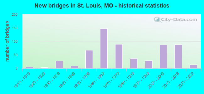
- New bridges - historical statistics
- 1Before 1900
- 11900-1909
- 61910-1919
- 31920-1929
- 281930-1939
- 91940-1949
- 671950-1959
- 1481960-1969
- 901970-1979
- 371980-1989
- 291990-1999
- 872000-2009
- 882010-2019
- 142020-2022
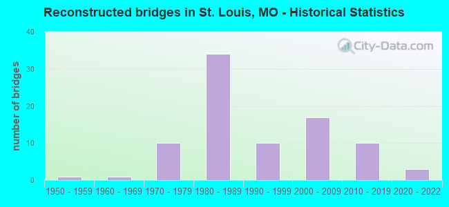
- Reconstructed bridges - Historical Statistics
- 11950-1959
- 11960-1969
- 101970-1979
- 341980-1989
- 101990-1999
- 172000-2009
- 102010-2019
- 32020-2022
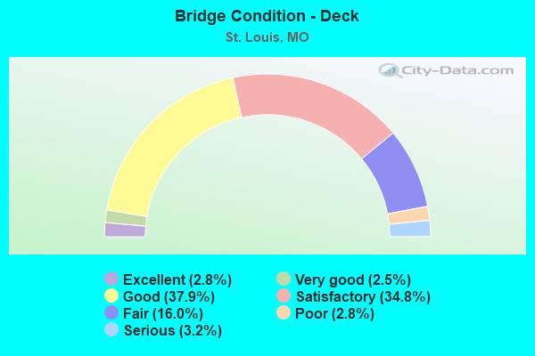
- Bridge Condition - Deck
- 2.8%Excellent
- 2.5%Very good
- 37.9%Good
- 34.8%Satisfactory
- 16.0%Fair
- 2.8%Poor
- 3.2%Serious
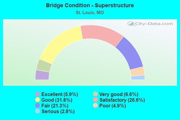
- Bridge Condition - Superstructure
- 5.9%Excellent
- 6.6%Very good
- 31.8%Good
- 26.6%Satisfactory
- 21.3%Fair
- 4.9%Poor
- 2.8%Serious
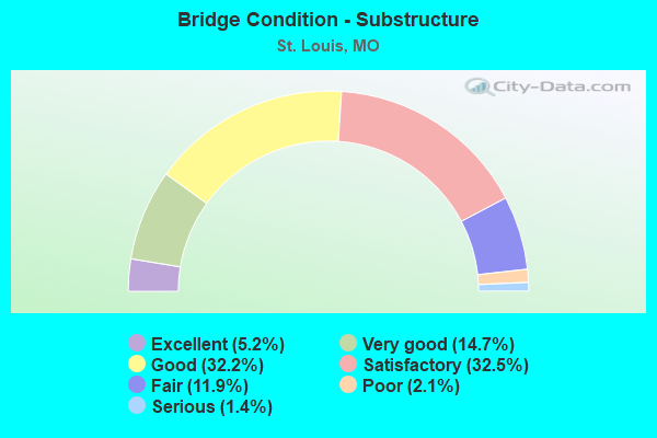
- Bridge Condition - Substructure
- 5.2%Excellent
- 14.7%Very good
- 32.2%Good
- 32.5%Satisfactory
- 11.9%Fair
- 2.1%Poor
- 1.4%Serious
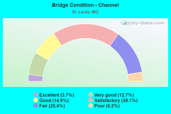
- Bridge Condition - Channel
- 3.7%Excellent
- 12.7%Very good
- 14.9%Good
- 38.1%Satisfactory
- 25.4%Fair
- 5.2%Poor
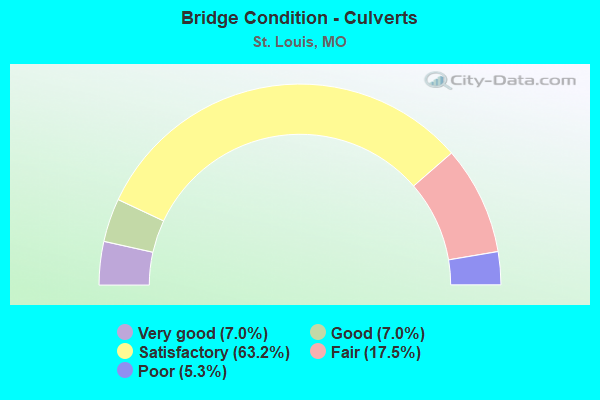
- Bridge Condition - Culverts
- 7.0%Very good
- 7.0%Good
- 63.2%Satisfactory
- 17.5%Fair
- 5.3%Poor
Find on map >> Show street view
Structure Number: 30667, Location: S 35 T 46 N R 7 E (Lat: 38.681028, Lng: -90.208436), Route carried "under" structure: City street , Year Built: 1975, Structure Length: 0. m, Average Daily Traffic: 464 (year 2021), Truck Traffic: 4%, Features Intersected: CST BULWER AVE, Facility Carried by Structure: RT H N
Minimum Vertical Clearance: 9.04m (29.66ft), Kilometerpoint: 0.903, Lanes on structure: 4, Lanes under structure: 2, Material/Design: Steel continuous, Design/Construction: Stringer/Multi-beam, Length of Maximum Span: 32.0m (105.0ft)
Find on map >> Show street view
Structure Number: 30667, Location: S 35 T 46 N R 7 E (Lat: 38.681028, Lng: -90.208436), Route carried "under" structure: City street , Year Built: 1975, Structure Length: 0. m, Average Daily Traffic: 118 (year 2021), Truck Traffic: 5%, Features Intersected: CST 2ND ST, Facility Carried by Structure: RT H N
Minimum Vertical Clearance: 6.86m (22.51ft), Kilometerpoint: 0.000, Lanes on structure: 4, Lanes under structure: 2, Material/Design: Steel continuous, Design/Construction: Stringer/Multi-beam, Length of Maximum Span: 32.0m (105.0ft)
Find on map >> Show street view
Structure Number: 30667, Location: S 35 T 46 N R 7 E (Lat: 38.681028, Lng: -90.208436), Route carried "under" structure: City street , Year Built: 1975, Structure Length: 0. m, Average Daily Traffic: 234 (year 2021), Truck Traffic: 4%, Features Intersected: CST MC KISSOCK AVE, Facility Carried by Structure: RT H N
Minimum Vertical Clearance: 8.23m (27.00ft), Kilometerpoint: 0.000, Lanes on structure: 4, Lanes under structure: 2, Material/Design: Steel continuous, Design/Construction: Stringer/Multi-beam, Length of Maximum Span: 32.0m (105.0ft)
Find on map >> Show street view
Structure Number: 30828, Location: S 22 T 45 N R 7 E (Lat: 38.631075, Lng: -90.227244), Route carried "under" structure: Ramp State highway , Year Built: 2005, Structure Length: 0. m, Average Daily Traffic: 8,322 (year 2021), Truck Traffic: 18%, Features Intersected: RP IS64W TO FOREST PARK, Facility Carried by Structure: COMPTON AVE S
Minimum Vertical Clearance: 4.94m (16.21ft), Kilometerpoint: 0.282, Lanes on structure: 6, Lanes under structure: 2, Material/Design: Prestressed concrete, Design/Construction: Box Beam or Girders - Single/Spread, Length of Maximum Span: 16.8m (55.1ft)
Find on map >> Show street view
Structure Number: 3083, Location: S 22 T 45 N R 7 E (Lat: 38.630361, Lng: -90.227519), Route carried "under" structure: Interstate 64, Year Built: 2005, Structure Length: 0. m, Average Daily Traffic: 45,690 (year 2021), Truck Traffic: 12%, Features Intersected: IS 64, Facility Carried by Structure: COMPTON AVE S
Minimum Vertical Clearance: 4.60m (15.09ft), Kilometerpoint: 61.522, Lanes on structure: 4, Lanes under structure: 4, Material/Design: Steel continuous, Design/Construction: Stringer/Multi-beam, Length of Maximum Span: 32.2m (105.6ft)
Find on map >> Show street view
Structure Number: 3083, Location: S 22 T 45 N R 7 E (Lat: 38.630361, Lng: -90.227519), Route carried "under" structure: Interstate 64, Year Built: 2005, Structure Length: 0. m, Average Daily Traffic: 48,720 (year 2021), Truck Traffic: 18%, Features Intersected: IS 64, Facility Carried by Structure: COMPTON AVE S
Minimum Vertical Clearance: 4.70m (15.42ft), Kilometerpoint: 4.163, Lanes on structure: 4, Lanes under structure: 3, Material/Design: Steel continuous, Design/Construction: Stringer/Multi-beam, Length of Maximum Span: 32.2m (105.6ft)
Find on map >> Show street view
Structure Number: 3108, Location: S 3963 T 45 N R 7 E (Lat: 38.630575, Lng: -90.251244), Route carried "under" structure: Ramp State highway , Year Built: 1977, Structure Length: 0. m, Average Daily Traffic: 6,048 (year 2021), Truck Traffic: 18%, Features Intersected: RP VANDEVENTER AVE TO IS, Facility Carried by Structure: RP PAPIN ST E TO I
Minimum Vertical Clearance: 4.72m (15.49ft), Kilometerpoint: 0.426, Lanes on structure: 1, Lanes under structure: 1, Material/Design: Steel continuous, Design/Construction: Stringer/Multi-beam, Length of Maximum Span: 17.7m (58.1ft)
Find on map >> Show street view
Structure Number: 3108, Location: S 3963 T 45 N R 7 E (Lat: 38.630575, Lng: -90.251244), Route carried "under" structure: Ramp State highway , Year Built: 1977, Structure Length: 0. m, Average Daily Traffic: 6,794 (year 2021), Truck Traffic: 18%, Features Intersected: RP IS64E TO VANDEVENTER, Facility Carried by Structure: RP PAPIN ST E TO I
Minimum Vertical Clearance: 4.72m (15.49ft), Kilometerpoint: 0.177, Lanes on structure: 1, Lanes under structure: 2, Material/Design: Steel continuous, Design/Construction: Stringer/Multi-beam, Length of Maximum Span: 17.7m (58.1ft)
Find on map >> Show street view
Structure Number: 31443, Location: S 23 T 45 N R 7 E (Lat: 38.621558, Lng: -90.194294), Route carried "under" structure: City street , Year Built: 2006, Structure Length: 0. m, Average Daily Traffic: 6,286 (year 2021), Truck Traffic: 10%, Features Intersected: CST BROADWAY, Facility Carried by Structure: RP 6TH ST TO IS64E
Minimum Vertical Clearance: 4.83m (15.85ft), Kilometerpoint: 13.210, Lanes on structure: 1, Lanes under structure: 4, Material/Design: Steel continuous, Design/Construction: Stringer/Multi-beam, Length of Maximum Span: 35.1m (115.2ft)
Find on map >> Show street view
Structure Number: 32128, Location: S 13 T 45 N R 6 E (Lat: 38.632344, Lng: -90.293628), Route carried "under" structure: Interstate 64, Year Built: 2007, Structure Length: 0. m, Average Daily Traffic: 75,423 (year 2021), Truck Traffic: 18%, Features Intersected: IS 64, Facility Carried by Structure: TAMM AVE S
Minimum Vertical Clearance: 4.85m (15.91ft), Kilometerpoint: 10.071, Lanes on structure: 4, Lanes under structure: 4, Material/Design: Prestressed concrete continuous, Design/Construction: Stringer/Multi-beam, Length of Maximum Span: 23.2m (76.1ft)
Find on map >> Show street view
Structure Number: 32128, Location: S 13 T 45 N R 6 E (Lat: 38.632344, Lng: -90.293628), Route carried "under" structure: Interstate 64, Year Built: 2007, Structure Length: 0. m, Average Daily Traffic: 79,712 (year 2021), Truck Traffic: 12%, Features Intersected: IS 64, Facility Carried by Structure: TAMM AVE S
Minimum Vertical Clearance: 4.88m (16.01ft), Kilometerpoint: 55.613, Lanes on structure: 4, Lanes under structure: 4, Material/Design: Prestressed concrete continuous, Design/Construction: Stringer/Multi-beam, Length of Maximum Span: 23.2m (76.1ft)
Find on map >> Show street view
Structure Number: 32226, Location: S 23 T 45 N R 6 E (Lat: 38.630008, Lng: -90.306500), Route carried "under" structure: City street , Year Built: 2008, Structure Length: 0. m, Average Daily Traffic: 9,550 (year 2021), Truck Traffic: 5%, Features Intersected: CST MCCAUSLAND AVE, Facility Carried by Structure: IS 64 E
Minimum Vertical Clearance: 4.88m (16.01ft), Kilometerpoint: 0.340, Lanes on structure: 6, Lanes under structure: 3, Material/Design: Prestressed concrete continuous, Design/Construction: Stringer/Multi-beam, Length of Maximum Span: 22.9m (75.1ft)
Find on map >> Show street view
Structure Number: 32226, Location: S 23 T 45 N R 6 E (Lat: 38.630008, Lng: -90.306500), Route carried "under" structure: City street , Year Built: 2008, Structure Length: 0. m, Average Daily Traffic: 9,534 (year 2021), Truck Traffic: 5%, Features Intersected: CST MCCAUSLAND AVE, Facility Carried by Structure: IS 64 E
Minimum Vertical Clearance: 4.88m (16.01ft), Kilometerpoint: 2.453, Lanes on structure: 6, Lanes under structure: 3, Material/Design: Prestressed concrete continuous, Design/Construction: Stringer/Multi-beam, Length of Maximum Span: 22.9m (75.1ft)
Find on map >> Show street view
Structure Number: 3223, Location: S 17 T 45 N R 7 E (Lat: 38.631067, Lng: -90.249139), Route carried "under" structure: City street , Year Built: 1982, Structure Length: 0. m, Average Daily Traffic: 7,360 (year 2021), Truck Traffic: 5%, Features Intersected: CST N SARAH ST, Facility Carried by Structure: IS 64 E
Minimum Vertical Clearance: 4.71m (15.45ft), Kilometerpoint: 4.068, Lanes on structure: 4, Lanes under structure: 2, Material/Design: Prestressed concrete continuous, Design/Construction: Stringer/Multi-beam, Length of Maximum Span: 18.6m (61.0ft)
Find on map >> Show street view
Structure Number: 32236, Location: S 19 T 45 N R 7 E (Lat: 38.633194, Lng: -90.266383), Route carried "under" structure: City street , Year Built: 2008, Structure Length: 0. m, Average Daily Traffic: 5,704 (year 2021), Truck Traffic: 5%, Features Intersected: CST CLAYTON AVE, Facility Carried by Structure: KINGSHIGHWAY BLVD
Minimum Vertical Clearance: 4.77m (15.65ft), Kilometerpoint: 1.239, Lanes on structure: 8, Lanes under structure: 2, Material/Design: Prestressed concrete, Design/Construction: Stringer/Multi-beam, Length of Maximum Span: 19.2m (63.0ft)
Find on map >> Show street view
Structure Number: 32237, Location: S 19 T 45 N R 7 E (Lat: 38.631186, Lng: -90.265614), Route carried "under" structure: Interstate 64, Year Built: 2008, Structure Length: 0. m, Average Daily Traffic: 67,344 (year 2021), Truck Traffic: 12%, Features Intersected: IS 64, Facility Carried by Structure: KINGSHIGHWAY BLVD
Minimum Vertical Clearance: 4.76m (15.62ft), Kilometerpoint: 58.115, Lanes on structure: 8, Lanes under structure: 4, Material/Design: Prestressed concrete continuous, Design/Construction: Stringer/Multi-beam, Length of Maximum Span: 22.9m (75.1ft)
Find on map >> Show street view
Structure Number: 32237, Location: S 19 T 45 N R 7 E (Lat: 38.631186, Lng: -90.265614), Route carried "under" structure: Interstate 64, Year Built: 2008, Structure Length: 0. m, Average Daily Traffic: 60,676 (year 2021), Truck Traffic: 18%, Features Intersected: IS 64, Facility Carried by Structure: KINGSHIGHWAY BLVD
Minimum Vertical Clearance: 4.76m (15.62ft), Kilometerpoint: 7.580, Lanes on structure: 8, Lanes under structure: 4, Material/Design: Prestressed concrete continuous, Design/Construction: Stringer/Multi-beam, Length of Maximum Span: 22.9m (75.1ft)
Find on map >> Show street view
Structure Number: 32254, Location: S 13 T 45 N R 6 E (Lat: 38.632558, Lng: -90.300889), Route carried "under" structure: Interstate 64, Year Built: 2008, Structure Length: 0. m, Average Daily Traffic: 75,423 (year 2021), Truck Traffic: 18%, Features Intersected: IS 64, Facility Carried by Structure: RP SKINKER BLVD TO
Minimum Vertical Clearance: 4.67m (15.32ft), Kilometerpoint: 10.728, Lanes on structure: 2, Lanes under structure: 3, Material/Design: Prestressed concrete continuous, Design/Construction: Tee Beam, Length of Maximum Span: 37.9m (124.3ft)
Find on map >> Show street view
Structure Number: 32254, Location: S 13 T 45 N R 6 E (Lat: 38.632558, Lng: -90.300889), Route carried "under" structure: Interstate 64, Year Built: 2008, Structure Length: 0. m, Average Daily Traffic: 79,712 (year 2021), Truck Traffic: 12%, Features Intersected: IS 64, Facility Carried by Structure: RP SKINKER BLVD TO
Minimum Vertical Clearance: 4.73m (15.52ft), Kilometerpoint: 54.991, Lanes on structure: 2, Lanes under structure: 3, Material/Design: Prestressed concrete continuous, Design/Construction: Tee Beam, Length of Maximum Span: 37.9m (124.3ft)
Find on map >> Show street view
Structure Number: 3226, Location: S 19 T 45 N R 7 E (Lat: 38.631150, Lng: -90.286622), Route carried "under" structure: Ramp State highway , Year Built: 2008, Structure Length: 0. m, Average Daily Traffic: 2,591 (year 2021), Truck Traffic: 18%, Features Intersected: RP IS64E TO OAKVIEW PL, Facility Carried by Structure: HAMPTON AVE S
Minimum Vertical Clearance: 4.83m (15.85ft), Kilometerpoint: 0.462, Lanes on structure: 7, Lanes under structure: 1, Material/Design: Prestressed concrete, Design/Construction: Box Beam or Girders - Multiple, Length of Maximum Span: 12.5m (41.0ft)
Find on map >> Show street view
Structure Number: 32266, Location: S 19 T 45 N R 7 E (Lat: 38.631622, Lng: -90.286458), Route carried "under" structure: Interstate 64, Year Built: 2008, Structure Length: 0. m, Average Daily Traffic: 63,865 (year 2021), Truck Traffic: 18%, Features Intersected: IS 64, Facility Carried by Structure: CONCOURSE DR S
Minimum Vertical Clearance: 4.88m (16.01ft), Kilometerpoint: 9.437, Lanes on structure: 7, Lanes under structure: 4, Material/Design: Prestressed concrete continuous, Design/Construction: Stringer/Multi-beam, Length of Maximum Span: 22.5m (73.8ft)
Find on map >> Show street view
Structure Number: 32266, Location: S 19 T 45 N R 7 E (Lat: 38.631622, Lng: -90.286458), Route carried "under" structure: Interstate 64, Year Built: 2008, Structure Length: 0. m, Average Daily Traffic: 79,712 (year 2021), Truck Traffic: 12%, Features Intersected: IS 64, Facility Carried by Structure: CONCOURSE DR S
Minimum Vertical Clearance: 4.88m (16.01ft), Kilometerpoint: 56.245, Lanes on structure: 7, Lanes under structure: 4, Material/Design: Prestressed concrete continuous, Design/Construction: Stringer/Multi-beam, Length of Maximum Span: 22.5m (73.8ft)
Find on map >> Show street view
Structure Number: 32268, Location: S 23 T 45 N R 6 E (Lat: 38.631739, Lng: -90.302928), Route carried "under" structure: Interstate 64, Year Built: 2008, Structure Length: 0. m, Average Daily Traffic: 79,712 (year 2021), Truck Traffic: 12%, Features Intersected: IS 64, Facility Carried by Structure: CLAYTON AVE E
Minimum Vertical Clearance: 5.03m (16.50ft), Kilometerpoint: 54.785, Lanes on structure: 2, Lanes under structure: 3, Material/Design: Prestressed concrete continuous, Design/Construction: Stringer/Multi-beam, Length of Maximum Span: 24.5m (80.4ft)
Find on map >> Show street view
Structure Number: 32268, Location: S 23 T 45 N R 6 E (Lat: 38.631739, Lng: -90.302928), Route carried "under" structure: Interstate 64, Year Built: 2008, Structure Length: 0. m, Average Daily Traffic: 75,423 (year 2021), Truck Traffic: 18%, Features Intersected: IS 64, Facility Carried by Structure: CLAYTON AVE E
Minimum Vertical Clearance: 5.03m (16.50ft), Kilometerpoint: 10.918, Lanes on structure: 2, Lanes under structure: 3, Material/Design: Prestressed concrete continuous, Design/Construction: Stringer/Multi-beam, Length of Maximum Span: 24.5m (80.4ft)
Find on map >> Show street view
Structure Number: 32268, Location: S 23 T 45 N R 6 E (Lat: 38.631739, Lng: -90.302928), Route carried "under" structure: Ramp State highway , Year Built: 2008, Structure Length: 0. m, Average Daily Traffic: 887 (year 2021), Truck Traffic: 10%, Features Intersected: RP US40W TO MCCAUSLAND A, Facility Carried by Structure: CLAYTON AVE E
Minimum Vertical Clearance: 5.03m (16.50ft), Kilometerpoint: 0.024, Lanes on structure: 2, Lanes under structure: 1, Material/Design: Prestressed concrete continuous, Design/Construction: Stringer/Multi-beam, Length of Maximum Span: 24.5m (80.4ft)
Find on map >> Show street view
Structure Number: 32269, Location: S 24 T 45 N R 6 E (Lat: 38.632372, Lng: -90.301522), Route carried "under" structure: Interstate 64, Year Built: 2008, Structure Length: 0. m, Average Daily Traffic: 79,712 (year 2021), Truck Traffic: 12%, Features Intersected: IS 64, Facility Carried by Structure: OAKLAND AVE E
Minimum Vertical Clearance: 4.80m (15.75ft), Kilometerpoint: 54.938, Lanes on structure: 2, Lanes under structure: 3, Material/Design: Prestressed concrete continuous, Design/Construction: Tee Beam, Length of Maximum Span: 45.5m (149.3ft)
Find on map >> Show street view
Structure Number: 32269, Location: S 24 T 45 N R 6 E (Lat: 38.632372, Lng: -90.301522), Route carried "under" structure: Interstate 64, Year Built: 2008, Structure Length: 0. m, Average Daily Traffic: 75,423 (year 2021), Truck Traffic: 18%, Features Intersected: IS 64, Facility Carried by Structure: OAKLAND AVE E
Minimum Vertical Clearance: 4.80m (15.75ft), Kilometerpoint: 10.784, Lanes on structure: 2, Lanes under structure: 4, Material/Design: Prestressed concrete continuous, Design/Construction: Tee Beam, Length of Maximum Span: 45.5m (149.3ft)
Find on map >> Show street view
Structure Number: 33066, Location: S 14 T 45 N R 7 E (Lat: 38.644656, Lng: -90.182569), Route carried "under" structure: City street , Year Built: 2010, Structure Length: 0. m, Average Daily Traffic: 2,911 (year 2021), Truck Traffic: 11%, Features Intersected: CST BROADWAY, Facility Carried by Structure: IS 70 E
Minimum Vertical Clearance: 4.78m (15.68ft), Kilometerpoint: 10.585, Lanes on structure: 4, Lanes under structure: 4, Material/Design: Steel continuous, Design/Construction: Stayed Girder, Length of Maximum Span: 457.2m (1,500.0ft)
Find on map >> Show street view
Structure Number: 33066, Location: S 14 T 45 N R 7 E (Lat: 38.644656, Lng: -90.182569), Route carried "under" structure: City street , Year Built: 2010, Structure Length: 0. m, Average Daily Traffic: 59 (year 2021), Truck Traffic: 5%, Features Intersected: CST 1ST ST, Facility Carried by Structure: IS 70 E
Minimum Vertical Clearance: 14.45m (47.41ft), Kilometerpoint: 0.726, Lanes on structure: 4, Lanes under structure: 2, Material/Design: Steel continuous, Design/Construction: Stayed Girder, Length of Maximum Span: 457.2m (1,500.0ft)
Find on map >> Show street view
Structure Number: 33066, Location: S 14 T 45 N R 7 E (Lat: 38.644656, Lng: -90.182569), Route carried "under" structure: Other road , Year Built: 2010, Structure Length: 0. m, Average Daily Traffic: 100 (year 2018), Truck Traffic: 10%, Features Intersected: LEVEE ROAD, Facility Carried by Structure: IS 70 E
Minimum Vertical Clearance: 10.06m (33.01ft), Kilometerpoint: 0.000, Lanes on structure: 4, Lanes under structure: 2, Material/Design: Steel continuous, Design/Construction: Stayed Girder, Length of Maximum Span: 457.2m (1,500.0ft)
Find on map >> Show street view
Structure Number: 33066, Location: S 14 T 45 N R 7 E (Lat: 38.644656, Lng: -90.182569), Route carried "under" structure: State highway 3, Year Built: 2010, Structure Length: 0. m, Average Daily Traffic: 500 (year 2018), Truck Traffic: 10%, Features Intersected: RTE. 3, Facility Carried by Structure: IS 70 E
Minimum Vertical Clearance: 12.27m (40.26ft), Kilometerpoint: 0.000, Lanes on structure: 4, Lanes under structure: 2, Material/Design: Steel continuous, Design/Construction: Stayed Girder, Length of Maximum Span: 457.2m (1,500.0ft)
Find on map >> Show street view
Structure Number: 33134, Location: S 17 T 44 N R 6 E (Lat: 38.560233, Lng: -90.255267), Route carried "under" structure: Interstate 55, Year Built: 2011, Structure Length: 0. m, Average Daily Traffic: 47,083 (year 2021), Truck Traffic: 12%, Features Intersected: IS 55, Facility Carried by Structure: HOLLY HILLS AVE E
Minimum Vertical Clearance: 4.93m (16.17ft), Kilometerpoint: 10.459, Lanes on structure: 2, Lanes under structure: 4, Material/Design: Prestressed concrete continuous, Design/Construction: Box Beam or Girders - Single/Spread, Length of Maximum Span: 22.6m (74.1ft)
Find on map >> Show street view
Structure Number: 33134, Location: S 17 T 44 N R 6 E (Lat: 38.560233, Lng: -90.255267), Route carried "under" structure: Interstate 55, Year Built: 2011, Structure Length: 0. m, Average Daily Traffic: 47,675 (year 2021), Truck Traffic: 12%, Features Intersected: IS 55, Facility Carried by Structure: HOLLY HILLS AVE E
Minimum Vertical Clearance: 5.31m (17.42ft), Kilometerpoint: 327.203, Lanes on structure: 2, Lanes under structure: 4, Material/Design: Prestressed concrete continuous, Design/Construction: Box Beam or Girders - Single/Spread, Length of Maximum Span: 22.6m (74.1ft)
Find on map >> Show street view
Structure Number: 33137, Location: S 9 T 44 N R 7 E (Lat: 38.569289, Lng: -90.239075), Route carried "under" structure: Interstate 55, Year Built: 2011, Structure Length: 0. m, Average Daily Traffic: 48,267 (year 2021), Truck Traffic: 12%, Features Intersected: IS 55, Facility Carried by Structure: DELOR ST E
Minimum Vertical Clearance: 4.90m (16.08ft), Kilometerpoint: 329.033, Lanes on structure: 2, Lanes under structure: 4, Material/Design: Prestressed concrete continuous, Design/Construction: Box Beam or Girders - Single/Spread, Length of Maximum Span: 21.2m (69.6ft)
Find on map >> Show street view
Structure Number: 33137, Location: S 9 T 44 N R 7 E (Lat: 38.569289, Lng: -90.239075), Route carried "under" structure: Interstate 55, Year Built: 2011, Structure Length: 0. m, Average Daily Traffic: 47,660 (year 2021), Truck Traffic: 12%, Features Intersected: IS 55, Facility Carried by Structure: DELOR ST E
Minimum Vertical Clearance: 4.85m (15.91ft), Kilometerpoint: 8.634, Lanes on structure: 2, Lanes under structure: 4, Material/Design: Prestressed concrete continuous, Design/Construction: Box Beam or Girders - Single/Spread, Length of Maximum Span: 21.2m (69.6ft)
Find on map >> Show street view
Structure Number: 33276, Location: S 14 T 45 N R 7 E (Lat: 38.639722, Lng: -90.187281), Route carried "under" structure: Ramp State highway , Year Built: 2011, Structure Length: 0. m, Average Daily Traffic: 2,326 (year 2021), Truck Traffic: 18%, Features Intersected: RP RV70E TO BROADWAY, Facility Carried by Structure: CASS AVE E
Minimum Vertical Clearance: 8.51m (27.92ft), Kilometerpoint: 0.225, Lanes on structure: 4, Lanes under structure: 1, Material/Design: Steel continuous, Design/Construction: Stringer/Multi-beam, Length of Maximum Span: 41.8m (137.1ft)
Find on map >> Show street view
Structure Number: 33276, Location: S 14 T 45 N R 7 E (Lat: 38.639722, Lng: -90.187281), Route carried "under" structure: State highway 70, Year Built: 2011, Structure Length: 0. m, Average Daily Traffic: 11,247 (year 2021), Truck Traffic: 10%, Features Intersected: RV 70, Facility Carried by Structure: CASS AVE E
Minimum Vertical Clearance: 8.41m (27.59ft), Kilometerpoint: 9.238, Lanes on structure: 4, Lanes under structure: 1, Material/Design: Steel continuous, Design/Construction: Stringer/Multi-beam, Length of Maximum Span: 41.8m (137.1ft)
Find on map >> Show street view
Structure Number: 33276, Location: S 14 T 45 N R 7 E (Lat: 38.639722, Lng: -90.187281), Route carried "under" structure: Ramp State highway , Year Built: 2011, Structure Length: 0. m, Average Daily Traffic: 4,668 (year 2021), Truck Traffic: 18%, Features Intersected: RP IS44W TO BROADWAY, Facility Carried by Structure: CASS AVE E
Minimum Vertical Clearance: 7.67m (25.16ft), Kilometerpoint: 0.224, Lanes on structure: 4, Lanes under structure: 2, Material/Design: Steel continuous, Design/Construction: Stringer/Multi-beam, Length of Maximum Span: 41.8m (137.1ft)
Find on map >> Show street view
Structure Number: 33276, Location: S 14 T 45 N R 7 E (Lat: 38.639722, Lng: -90.187281), Route carried "under" structure: Interstate 44, Year Built: 2011, Structure Length: 0. m, Average Daily Traffic: 40,002 (year 2021), Truck Traffic: 18%, Features Intersected: IS 44, Facility Carried by Structure: CASS AVE E
Minimum Vertical Clearance: 7.60m (24.93ft), Kilometerpoint: 471.069, Lanes on structure: 4, Lanes under structure: 3, Material/Design: Steel continuous, Design/Construction: Stringer/Multi-beam, Length of Maximum Span: 41.8m (137.1ft)
Find on map >> Show street view
Structure Number: 33276, Location: S 14 T 45 N R 7 E (Lat: 38.639722, Lng: -90.187281), Route carried "under" structure: Interstate 44, Year Built: 2011, Structure Length: 0. m, Average Daily Traffic: 41,956 (year 2021), Truck Traffic: 18%, Features Intersected: IS 44, Facility Carried by Structure: CASS AVE E
Minimum Vertical Clearance: 7.78m (25.52ft), Kilometerpoint: 0.681, Lanes on structure: 4, Lanes under structure: 2, Material/Design: Steel continuous, Design/Construction: Stringer/Multi-beam, Length of Maximum Span: 41.8m (137.1ft)
Find on map >> Show street view
Structure Number: 33654, Location: S 14 T 45 N R 7 E (Lat: 38.643069, Lng: -90.188669), Route carried "under" structure: Ramp State highway , Year Built: 2013, Structure Length: 0. m, Average Daily Traffic: 2,537 (year 2021), Truck Traffic: 18%, Features Intersected: RP IS44E TO 10TH ST, Facility Carried by Structure: IS 70 E
Minimum Vertical Clearance: 6.13m (20.11ft), Kilometerpoint: 0.060, Lanes on structure: 2, Lanes under structure: 1, Material/Design: Steel continuous, Design/Construction: Stringer/Multi-beam, Length of Maximum Span: 37.2m (122.0ft)
Find on map >> Show street view
Structure Number: 33654, Location: S 14 T 45 N R 7 E (Lat: 38.643069, Lng: -90.188669), Route carried "under" structure: Interstate 70, Year Built: 2013, Structure Length: 0. m, Average Daily Traffic: 19,392 (year 2021), Truck Traffic: 18%, Features Intersected: IS 70
Minimum Vertical Clearance: 5.74m (18.83ft), Kilometerpoint: 401.593, Lanes on structure: 2, Lanes under structure: 2, Material/Design: Steel continuous, Design/Construction: Stringer/Multi-beam, Length of Maximum Span: 37.2m (122.0ft)
Find on map >> Show street view
Structure Number: 33654, Location: S 14 T 45 N R 7 E (Lat: 38.643069, Lng: -90.188669), Route carried "under" structure: Interstate 44, Year Built: 2013, Structure Length: 0. m, Average Daily Traffic: 40,002 (year 2021), Truck Traffic: 18%, Features Intersected: IS 44, Facility Carried by Structure: IS 70 E
Minimum Vertical Clearance: 4.84m (15.88ft), Kilometerpoint: 471.489, Lanes on structure: 2, Lanes under structure: 3, Material/Design: Steel continuous, Design/Construction: Stringer/Multi-beam, Length of Maximum Span: 37.2m (122.0ft)
Find on map >> Show street view
Structure Number: 33654, Location: S 14 T 45 N R 7 E (Lat: 38.643069, Lng: -90.188669), Route carried "under" structure: State highway 70, Year Built: 2013, Structure Length: 0. m, Average Daily Traffic: 22,494 (year 2021), Truck Traffic: 10%, Features Intersected: RV 70
Minimum Vertical Clearance: 5.44m (17.85ft), Kilometerpoint: 8.816, Lanes on structure: 2, Lanes under structure: 2, Material/Design: Steel continuous, Design/Construction: Stringer/Multi-beam, Length of Maximum Span: 37.2m (122.0ft)
Find on map >> Show street view
Structure Number: 33656, Location: S 14 T 45 N R 7 E (Lat: 38.643969, Lng: -90.188814), Route carried "under" structure: Ramp State highway , Year Built: 2013, Structure Length: 0. m, Average Daily Traffic: 2,537 (year 2021), Truck Traffic: 18%, Features Intersected: RP IS44E TO 10TH ST, Facility Carried by Structure: IS 70 W
Minimum Vertical Clearance: 4.98m (16.34ft), Kilometerpoint: 0.166, Lanes on structure: 2, Lanes under structure: 1, Material/Design: Steel, Design/Construction: Stringer/Multi-beam, Length of Maximum Span: 29.9m (98.1ft)
Find on map >> Show street view
Structure Number: 33657, Location: S 14 T 45 N R 7 E (Lat: 38.643300, Lng: -90.188828), Route carried "under" structure: Interstate 44, Year Built: 2013, Structure Length: 0. m, Average Daily Traffic: 41,956 (year 2021), Truck Traffic: 18%, Features Intersected: IS 44, Facility Carried by Structure: RP IS70W TO TUCKER
Minimum Vertical Clearance: 30+ m (98+ ft), Kilometerpoint: 0.261, Lanes on structure: 2, Lanes under structure: 3, Material/Design: Prestressed concrete continuous, Design/Construction: Tee Beam, Length of Maximum Span: 38.4m (126.0ft)
Find on map >> Show street view
Structure Number: 33657, Location: S 14 T 45 N R 7 E (Lat: 38.643300, Lng: -90.188828), Route carried "under" structure: State highway 70, Year Built: 2013, Structure Length: 0. m, Average Daily Traffic: 22,494 (year 2021), Truck Traffic: 10%, Features Intersected: RV 70
Minimum Vertical Clearance: 12.96m (42.52ft), Kilometerpoint: 8.805, Lanes on structure: 2, Lanes under structure: 2, Material/Design: Prestressed concrete continuous, Design/Construction: Tee Beam, Length of Maximum Span: 38.4m (126.0ft)
Find on map >> Show street view
Structure Number: 33657, Location: S 14 T 45 N R 7 E (Lat: 38.643300, Lng: -90.188828), Route carried "under" structure: Interstate 70, Year Built: 2013, Structure Length: 0. m, Average Daily Traffic: 19,392 (year 2021), Truck Traffic: 18%, Features Intersected: IS 70
Minimum Vertical Clearance: 4.73m (15.52ft), Kilometerpoint: 401.609, Lanes on structure: 2, Lanes under structure: 2, Material/Design: Prestressed concrete continuous, Design/Construction: Tee Beam, Length of Maximum Span: 38.4m (126.0ft)
Find on map >> Show street view
Structure Number: 33657, Location: S 14 T 45 N R 7 E (Lat: 38.643300, Lng: -90.188828), Route carried "under" structure: Interstate 44, Year Built: 2013, Structure Length: 0. m, Average Daily Traffic: 40,002 (year 2021), Truck Traffic: 18%, Features Intersected: IS 44, Facility Carried by Structure: RP IS70W TO TUCKER
Minimum Vertical Clearance: 12.90m (42.32ft), Kilometerpoint: 471.515, Lanes on structure: 2, Lanes under structure: 2, Material/Design: Prestressed concrete continuous, Design/Construction: Tee Beam, Length of Maximum Span: 38.4m (126.0ft)
Find on map >> Show street view
Structure Number: 33657, Location: S 14 T 45 N R 7 E (Lat: 38.643300, Lng: -90.188828), Route carried "under" structure: Ramp State highway , Year Built: 2013, Structure Length: 0. m, Average Daily Traffic: 2,537 (year 2021), Truck Traffic: 18%, Features Intersected: RP IS44E TO 10TH ST, Facility Carried by Structure: RP IS70W TO TUCKER
Minimum Vertical Clearance: 13.03m (42.75ft), Kilometerpoint: 0.092, Lanes on structure: 2, Lanes under structure: 1, Material/Design: Prestressed concrete continuous, Design/Construction: Tee Beam, Length of Maximum Span: 38.4m (126.0ft)
Find on map >> Show street view
Structure Number: 33659, Location: S 14 T 45 N R 7 E (Lat: 38.642869, Lng: -90.188650), Route carried "under" structure: Interstate 44, Year Built: 2012, Structure Length: 0. m, Average Daily Traffic: 40,002 (year 2021), Truck Traffic: 18%, Features Intersected: IS 44, Facility Carried by Structure: RP TUCKER BLVD TO
Minimum Vertical Clearance: 6.48m (21.26ft), Kilometerpoint: 471.465, Lanes on structure: 1, Lanes under structure: 2, Material/Design: Prestressed concrete continuous, Design/Construction: Stringer/Multi-beam, Length of Maximum Span: 23.8m (78.1ft)
Find on map >> Show street view
Structure Number: 33659, Location: S 14 T 45 N R 7 E (Lat: 38.642869, Lng: -90.188650), Route carried "under" structure: Ramp State highway , Year Built: 2012, Structure Length: 0. m, Average Daily Traffic: 2,537 (year 2021), Truck Traffic: 18%, Features Intersected: RP IS44E TO 10TH ST, Facility Carried by Structure: RP TUCKER BLVD TO
Minimum Vertical Clearance: 6.48m (21.26ft), Kilometerpoint: 0.043, Lanes on structure: 1, Lanes under structure: 1, Material/Design: Prestressed concrete continuous, Design/Construction: Stringer/Multi-beam, Length of Maximum Span: 23.8m (78.1ft)
Find on map >> Show street view
Structure Number: 33659, Location: S 14 T 45 N R 7 E (Lat: 38.642869, Lng: -90.188650), Route carried "under" structure: State highway 70, Year Built: 2012, Structure Length: 0. m, Average Daily Traffic: 22,494 (year 2021), Truck Traffic: 10%, Features Intersected: RV 70, Facility Carried by Structure: RP TUCKER BLVD TO
Minimum Vertical Clearance: 5.84m (19.16ft), Kilometerpoint: 8.851, Lanes on structure: 1, Lanes under structure: 2, Material/Design: Prestressed concrete continuous, Design/Construction: Stringer/Multi-beam, Length of Maximum Span: 23.8m (78.1ft)
Find on map >> Show street view
Structure Number: 33659, Location: S 14 T 45 N R 7 E (Lat: 38.642869, Lng: -90.188650), Route carried "under" structure: Interstate 44, Year Built: 2012, Structure Length: 0. m, Average Daily Traffic: 41,956 (year 2021), Truck Traffic: 18%, Features Intersected: IS 44, Facility Carried by Structure: RP TUCKER BLVD TO
Minimum Vertical Clearance: 5.31m (17.42ft), Kilometerpoint: 0.307, Lanes on structure: 1, Lanes under structure: 3, Material/Design: Prestressed concrete continuous, Design/Construction: Stringer/Multi-beam, Length of Maximum Span: 23.8m (78.1ft)
Find on map >> Show street view
Structure Number: 34263, Location: S 17 T 45 N R 7 E (Lat: 38.632061, Lng: -90.260444), Route carried "under" structure: Interstate 64, Year Built: 2015, Structure Length: 0. m, Average Daily Traffic: 60,676 (year 2021), Truck Traffic: 18%, Features Intersected: IS 64, Facility Carried by Structure: TAYLOR AVE S
Minimum Vertical Clearance: 4.75m (15.58ft), Kilometerpoint: 7.102, Lanes on structure: 2, Lanes under structure: 5, Material/Design: Prestressed concrete, Design/Construction: Tee Beam, Length of Maximum Span: 25.9m (85.0ft)
Find on map >> Show street view
Structure Number: 34263, Location: S 17 T 45 N R 7 E (Lat: 38.632061, Lng: -90.260444), Route carried "under" structure: Interstate 64, Year Built: 2015, Structure Length: 0. m, Average Daily Traffic: 59,863 (year 2021), Truck Traffic: 12%, Features Intersected: IS 64, Facility Carried by Structure: TAYLOR AVE S
Minimum Vertical Clearance: 6.20m (20.34ft), Kilometerpoint: 58.580, Lanes on structure: 2, Lanes under structure: 5, Material/Design: Prestressed concrete, Design/Construction: Tee Beam, Length of Maximum Span: 25.9m (85.0ft)
Find on map >> Show street view
Structure Number: 34264, Location: S 17 T 45 N R 7 E (Lat: 38.631225, Lng: -90.257444), Route carried "under" structure: Interstate 64, Year Built: 2013, Structure Length: 0. m, Average Daily Traffic: 59,863 (year 2021), Truck Traffic: 12%, Features Intersected: IS 64, Facility Carried by Structure: NEWSTEAD AVE S
Minimum Vertical Clearance: 4.72m (15.49ft), Kilometerpoint: 58.857, Lanes on structure: 2, Lanes under structure: 5, Material/Design: Prestressed concrete, Design/Construction: Tee Beam, Length of Maximum Span: 32.0m (105.0ft)
Find on map >> Show street view
Structure Number: 34264, Location: S 17 T 45 N R 7 E (Lat: 38.631225, Lng: -90.257444), Route carried "under" structure: Interstate 64, Year Built: 2013, Structure Length: 0. m, Average Daily Traffic: 60,676 (year 2021), Truck Traffic: 18%, Features Intersected: IS 64, Facility Carried by Structure: NEWSTEAD AVE S
Minimum Vertical Clearance: 4.88m (16.01ft), Kilometerpoint: 6.824, Lanes on structure: 2, Lanes under structure: 5, Material/Design: Prestressed concrete, Design/Construction: Tee Beam, Length of Maximum Span: 32.0m (105.0ft)
Find on map >> Show street view
Structure Number: 34265, Location: S 17 T 45 N R 7 E (Lat: 38.630975, Lng: -90.254742), Route carried "under" structure: Ramp State highway , Year Built: 2014, Structure Length: 0. m, Average Daily Traffic: 3,066 (year 2021), Truck Traffic: 10%, Features Intersected: RP BOYLE AVE TO IS64W, Facility Carried by Structure: TOWER GROVE AVE S
Minimum Vertical Clearance: 5.25m (17.22ft), Kilometerpoint: 0.138, Lanes on structure: 2, Lanes under structure: 1, Material/Design: Prestressed concrete, Design/Construction: Stringer/Multi-beam, Length of Maximum Span: 23.8m (78.1ft)
Find on map >> Show street view
Structure Number: 34265, Location: S 17 T 45 N R 7 E (Lat: 38.630975, Lng: -90.254742), Route carried "under" structure: Interstate 64, Year Built: 2014, Structure Length: 0. m, Average Daily Traffic: 56,479 (year 2021), Truck Traffic: 18%, Features Intersected: IS 64, Facility Carried by Structure: TOWER GROVE AVE S
Minimum Vertical Clearance: 6.46m (21.19ft), Kilometerpoint: 6.582, Lanes on structure: 2, Lanes under structure: 4, Material/Design: Prestressed concrete, Design/Construction: Stringer/Multi-beam, Length of Maximum Span: 23.8m (78.1ft)
Find on map >> Show street view
Structure Number: 34265, Location: S 17 T 45 N R 7 E (Lat: 38.630975, Lng: -90.254742), Route carried "under" structure: Interstate 64, Year Built: 2014, Structure Length: 0. m, Average Daily Traffic: 59,863 (year 2021), Truck Traffic: 12%, Features Intersected: IS 64, Facility Carried by Structure: TOWER GROVE AVE S
Minimum Vertical Clearance: 5.27m (17.29ft), Kilometerpoint: 59.098, Lanes on structure: 2, Lanes under structure: 4, Material/Design: Prestressed concrete, Design/Construction: Stringer/Multi-beam, Length of Maximum Span: 23.8m (78.1ft)
Find on map >> Show street view
Structure Number: 34266, Location: S 20 T 45 N R 7 E (Lat: 38.631161, Lng: -90.253286), Route carried "under" structure: Interstate 64, Year Built: 2014, Structure Length: 0. m, Average Daily Traffic: 56,479 (year 2021), Truck Traffic: 18%, Features Intersected: IS 64, Facility Carried by Structure: BOYLE AVE S
Minimum Vertical Clearance: 4.65m (15.26ft), Kilometerpoint: 6.452, Lanes on structure: 3, Lanes under structure: 4, Material/Design: Prestressed concrete, Design/Construction: Tee Beam, Length of Maximum Span: 31.4m (103.0ft)
Find on map >> Show street view
Structure Number: 34266, Location: S 20 T 45 N R 7 E (Lat: 38.631161, Lng: -90.253286), Route carried "under" structure: Ramp State highway , Year Built: 2014, Structure Length: 0. m, Average Daily Traffic: 6,794 (year 2021), Truck Traffic: 18%, Features Intersected: RP IS64E TO VANDEVENTER, Facility Carried by Structure: BOYLE AVE S
Minimum Vertical Clearance: 4.57m (14.99ft), Kilometerpoint: 0.634, Lanes on structure: 3, Lanes under structure: 1, Material/Design: Prestressed concrete, Design/Construction: Tee Beam, Length of Maximum Span: 31.4m (103.0ft)
Find on map >> Show street view
Structure Number: 34266, Location: S 20 T 45 N R 7 E (Lat: 38.631161, Lng: -90.253286), Route carried "under" structure: Interstate 64, Year Built: 2014, Structure Length: 0. m, Average Daily Traffic: 55,174 (year 2021), Truck Traffic: 12%, Features Intersected: IS 64, Facility Carried by Structure: BOYLE AVE S
Minimum Vertical Clearance: 4.90m (16.08ft), Kilometerpoint: 59.224, Lanes on structure: 3, Lanes under structure: 3, Material/Design: Prestressed concrete, Design/Construction: Tee Beam, Length of Maximum Span: 31.4m (103.0ft)
Find on map >> Show street view
Structure Number: 34268, Location: S 22 T 45 N R 7 W (Lat: 38.627417, Lng: -90.217681), Route carried "under" structure: Interstate 64, Year Built: 2013, Structure Length: 0. m, Average Daily Traffic: 45,690 (year 2021), Truck Traffic: 12%, Features Intersected: IS 64, Facility Carried by Structure: JEFFERSON AVE S
Minimum Vertical Clearance: 5.03m (16.50ft), Kilometerpoint: 62.431, Lanes on structure: 5, Lanes under structure: 4, Material/Design: Prestressed concrete, Design/Construction: Tee Beam, Length of Maximum Span: 22.9m (75.1ft)
Find on map >> Show street view
Structure Number: 34268, Location: S 22 T 45 N R 7 W (Lat: 38.627417, Lng: -90.217681), Route carried "under" structure: Interstate 64, Year Built: 2013, Structure Length: 0. m, Average Daily Traffic: 63,466 (year 2021), Truck Traffic: 18%, Features Intersected: IS 64, Facility Carried by Structure: JEFFERSON AVE S
Minimum Vertical Clearance: 5.28m (17.32ft), Kilometerpoint: 3.251, Lanes on structure: 5, Lanes under structure: 4, Material/Design: Prestressed concrete, Design/Construction: Tee Beam, Length of Maximum Span: 22.9m (75.1ft)
Find on map >> Show street view
Structure Number: 34444, Location: S 24 T 45 N R 7 E (Lat: 38.623958, Lng: -90.187775), Route carried "under" structure: Interstate 44, Year Built: 2014, Structure Length: 0. m, Average Daily Traffic: 35,996 (year 2021), Truck Traffic: 18%, Features Intersected: IS 44, Facility Carried by Structure: WALNUT ST E
Minimum Vertical Clearance: 4.62m (15.16ft), Kilometerpoint: 469.292, Lanes on structure: 3, Lanes under structure: 3, Material/Design: Prestressed concrete, Design/Construction: Tee Beam, Length of Maximum Span: 28.7m (94.2ft)
Find on map >> Show street view
Structure Number: 34444, Location: S 24 T 45 N R 7 E (Lat: 38.623958, Lng: -90.187775), Route carried "under" structure: Interstate 44, Year Built: 2014, Structure Length: 0. m, Average Daily Traffic: 56,554 (year 2021), Truck Traffic: 18%, Features Intersected: IS 44, Facility Carried by Structure: WALNUT ST E
Minimum Vertical Clearance: 4.67m (15.32ft), Kilometerpoint: 2.475, Lanes on structure: 3, Lanes under structure: 3, Material/Design: Prestressed concrete, Design/Construction: Tee Beam, Length of Maximum Span: 28.7m (94.2ft)
Find on map >> Show street view
Structure Number: 34664, Location: S 23 T 45 N R 7 E (Lat: 38.619914, Lng: -90.188711), Route carried "under" structure: Ramp State highway , Year Built: 2015, Structure Length: 0. m, Average Daily Traffic: 1,972 (year 2021), Truck Traffic: 19%, Features Intersected: RP MEMORIAL DR TO IS44W, Facility Carried by Structure: IS 55 S
Minimum Vertical Clearance: 5.38m (17.65ft), Kilometerpoint: 0.143, Lanes on structure: 2, Lanes under structure: 1, Material/Design: Prestressed concrete continuous, Design/Construction: Tee Beam, Length of Maximum Span: 43.3m (142.1ft)
Find on map >> Show street view
Structure Number: 34664, Location: S 23 T 45 N R 7 E (Lat: 38.619914, Lng: -90.188711), Route carried "under" structure: Interstate 44, Year Built: 2015, Structure Length: 0. m, Average Daily Traffic: 56,554 (year 2021), Truck Traffic: 18%, Features Intersected: IS 44, Facility Carried by Structure: IS 55 S
Minimum Vertical Clearance: 5.89m (19.32ft), Kilometerpoint: 2.884, Lanes on structure: 2, Lanes under structure: 2, Material/Design: Prestressed concrete continuous, Design/Construction: Tee Beam, Length of Maximum Span: 43.3m (142.1ft)
Find on map >> Show street view
Structure Number: 34664, Location: S 23 T 45 N R 7 E (Lat: 38.619914, Lng: -90.188711), Route carried "under" structure: Interstate 44, Year Built: 2015, Structure Length: 0. m, Average Daily Traffic: 49,324 (year 2021), Truck Traffic: 18%, Features Intersected: IS 44, Facility Carried by Structure: IS 55 S
Minimum Vertical Clearance: 6.02m (19.75ft), Kilometerpoint: 468.885, Lanes on structure: 2, Lanes under structure: 2, Material/Design: Prestressed concrete continuous, Design/Construction: Tee Beam, Length of Maximum Span: 43.3m (142.1ft)
Find on map >> Show street view
Structure Number: 353, Location: S 2122 T 45 N R 7 E (Lat: 38.616639, Lng: -90.239392), Route carried "under" structure: Interstate 44, Year Built: 2016, Structure Length: 0. m, Average Daily Traffic: 43,302 (year 2021), Truck Traffic: 12%, Features Intersected: IS 44, Facility Carried by Structure: GRAND BLVD S
Minimum Vertical Clearance: 4.90m (16.08ft), Kilometerpoint: 463.909, Lanes on structure: 6, Lanes under structure: 4, Material/Design: Prestressed concrete continuous, Design/Construction: Tee Beam, Length of Maximum Span: 25.5m (83.7ft)
Find on map >> Show street view
Structure Number: 353, Location: S 2122 T 45 N R 7 E (Lat: 38.616639, Lng: -90.239392), Route carried "under" structure: Interstate 44, Year Built: 2016, Structure Length: 0. m, Average Daily Traffic: 43,426 (year 2021), Truck Traffic: 12%, Features Intersected: IS 44, Facility Carried by Structure: GRAND BLVD S
Minimum Vertical Clearance: 4.90m (16.08ft), Kilometerpoint: 7.784, Lanes on structure: 6, Lanes under structure: 4, Material/Design: Prestressed concrete continuous, Design/Construction: Tee Beam, Length of Maximum Span: 25.5m (83.7ft)
Find on map >> Show street view
Structure Number: 35737, Location: S 19 T 45 N R 6 E (Lat: 38.618317, Lng: -90.266472), Route carried "under" structure: City street , Year Built: 2018, Structure Length: 0. m, Average Daily Traffic: 40,956 (year 2021), Truck Traffic: 5%, Features Intersected: CST KINGSHIGHWAY BLVD, Facility Carried by Structure: IS 44 E
Minimum Vertical Clearance: 4.83m (15.85ft), Kilometerpoint: 9.003, Lanes on structure: 4, Lanes under structure: 7, Material/Design: Prestressed concrete, Design/Construction: Tee Beam, Length of Maximum Span: 20.4m (66.9ft)
Find on map >> Show street view
Structure Number: 35738, Location: S 19 T 45 N R 6 E (Lat: 38.618528, Lng: -90.266486), Route carried "under" structure: City street , Year Built: 2018, Structure Length: 0. m, Average Daily Traffic: 40,956 (year 2021), Truck Traffic: 5%, Features Intersected: CST KINGSHIGHWAY BLVD, Facility Carried by Structure: IS 44 W
Minimum Vertical Clearance: 4.80m (15.75ft), Kilometerpoint: 8.983, Lanes on structure: 4, Lanes under structure: 7, Material/Design: Prestressed concrete, Design/Construction: Tee Beam, Length of Maximum Span: 20.8m (68.2ft)
Find on map >> Show street view
Structure Number: 35744, Location: S 28 T 45 N R 7 E (Lat: 38.617097, Lng: -90.245028), Route carried "under" structure: City street , Year Built: 2018, Structure Length: 0. m, Average Daily Traffic: 3,467 (year 2021), Truck Traffic: 5%, Features Intersected: CST 39TH ST, Facility Carried by Structure: IS 44 E
Minimum Vertical Clearance: 4.74m (15.55ft), Kilometerpoint: 1.146, Lanes on structure: 4, Lanes under structure: 2, Material/Design: Prestressed concrete, Design/Construction: Tee Beam, Length of Maximum Span: 18.3m (60.0ft)
Find on map >> Show street view
Structure Number: 35745, Location: S 28 T 45 N R 7 E (Lat: 38.617289, Lng: -90.245008), Route carried "under" structure: City street , Year Built: 2018, Structure Length: 0. m, Average Daily Traffic: 3,467 (year 2021), Truck Traffic: 5%, Features Intersected: CST 39TH ST, Facility Carried by Structure: IS 44 W
Minimum Vertical Clearance: 4.98m (16.34ft), Kilometerpoint: 1.125, Lanes on structure: 4, Lanes under structure: 2, Material/Design: Prestressed concrete, Design/Construction: Tee Beam, Length of Maximum Span: 18.3m (60.0ft)
Find on map >> Show street view
Structure Number: 36247, Location: S 27 T 45 N R 7 E (Lat: 38.613797, Lng: -90.221211), Route carried "under" structure: City street , Year Built: 2019, Structure Length: 0. m, Average Daily Traffic: 24,684 (year 2021), Truck Traffic: 5%, Features Intersected: CST JEFFERSON AVE, Facility Carried by Structure: IS 44 W
Minimum Vertical Clearance: 4.73m (15.52ft), Kilometerpoint: 5.205, Lanes on structure: 4, Lanes under structure: 9, Material/Design: Steel, Design/Construction: Stringer/Multi-beam, Length of Maximum Span: 40.2m (131.9ft)
Find on map >> Show street view
Structure Number: 36249, Location: S 27 T 45 N R 7 E (Lat: 38.613619, Lng: -90.221267), Route carried "under" structure: City street , Year Built: 2019, Structure Length: 0. m, Average Daily Traffic: 21,702 (year 2021), Truck Traffic: 7%, Features Intersected: CST JEFFERSON AVE, Facility Carried by Structure: IS 44 E
Minimum Vertical Clearance: 4.73m (15.52ft), Kilometerpoint: 5.224, Lanes on structure: 4, Lanes under structure: 9, Material/Design: Steel, Design/Construction: Stringer/Multi-beam, Length of Maximum Span: 40.2m (131.9ft)
Find on map >> Show street view
Structure Number: 36382, Location: S 22 T 45 N R 7 E (Lat: 38.626589, Lng: -90.213589), Route carried "under" structure: Interstate 64, Year Built: 2020, Structure Length: 0. m, Average Daily Traffic: 63,466 (year 2021), Truck Traffic: 18%, Features Intersected: IS 64, Facility Carried by Structure: 22ND ST S
Minimum Vertical Clearance: 4.95m (16.24ft), Kilometerpoint: 2.890, Lanes on structure: 4, Lanes under structure: 3, Material/Design: Prestressed concrete, Design/Construction: Tee Beam, Length of Maximum Span: 33.6m (110.2ft)
Find on map >> Show street view
Structure Number: 36382, Location: S 22 T 45 N R 7 E (Lat: 38.626589, Lng: -90.213589), Route carried "under" structure: Interstate 64, Year Built: 2020, Structure Length: 0. m, Average Daily Traffic: 39,375 (year 2021), Truck Traffic: 12%, Features Intersected: IS 64, Facility Carried by Structure: 22ND ST S
Minimum Vertical Clearance: 4.95m (16.24ft), Kilometerpoint: 62.792, Lanes on structure: 4, Lanes under structure: 3, Material/Design: Prestressed concrete, Design/Construction: Tee Beam, Length of Maximum Span: 33.6m (110.2ft)
Find on map >> Show street view
Structure Number: 36383, Location: S 22 T 45 N R 7 E (Lat: 38.628969, Lng: -90.222161), Route carried "under" structure: Interstate 64, Year Built: 2020, Structure Length: 0. m, Average Daily Traffic: 45,690 (year 2021), Truck Traffic: 12%, Features Intersected: IS 64, Facility Carried by Structure: EWING AVE S
Minimum Vertical Clearance: 5.00m (16.40ft), Kilometerpoint: 62.013, Lanes on structure: 2, Lanes under structure: 5, Material/Design: Prestressed concrete continuous, Design/Construction: Tee Beam, Length of Maximum Span: 27.6m (90.6ft)
Find on map >> Show street view
Structure Number: 36383, Location: S 22 T 45 N R 7 E (Lat: 38.628969, Lng: -90.222161), Route carried "under" structure: Interstate 64, Year Built: 2020, Structure Length: 0. m, Average Daily Traffic: 48,720 (year 2021), Truck Traffic: 18%, Features Intersected: IS 64, Facility Carried by Structure: EWING AVE S
Minimum Vertical Clearance: 5.65m (18.54ft), Kilometerpoint: 3.673, Lanes on structure: 2, Lanes under structure: 5, Material/Design: Prestressed concrete continuous, Design/Construction: Tee Beam, Length of Maximum Span: 27.6m (90.6ft)
Find on map >> Show street view
Structure Number: 36695, Location: S 1 T 45 N R 7 E (Lat: 38.638269, Lng: -90.186231), Route carried "under" structure: State highway 70, Year Built: 2021, Structure Length: 0. m, Average Daily Traffic: 11,247 (year 2021), Truck Traffic: 10%, Features Intersected: RV 70, Facility Carried by Structure: BROADWAY S
Minimum Vertical Clearance: 5.25m (17.22ft), Kilometerpoint: 9.424, Lanes on structure: 2, Lanes under structure: 1, Material/Design: Prestressed concrete continuous, Design/Construction: Tee Beam, Length of Maximum Span: 30.2m (99.1ft)
Find on map >> Show street view
Structure Number: 36695, Location: S 1 T 45 N R 7 E (Lat: 38.638269, Lng: -90.186231), Route carried "under" structure: State highway 70, Year Built: 2021, Structure Length: 0. m, Average Daily Traffic: 5,500 (year 2021), Truck Traffic: 10%, Features Intersected: RV 70, Facility Carried by Structure: BROADWAY S
Minimum Vertical Clearance: 5.25m (17.22ft), Kilometerpoint: 0.172, Lanes on structure: 2, Lanes under structure: 1, Material/Design: Prestressed concrete continuous, Design/Construction: Tee Beam, Length of Maximum Span: 30.2m (99.1ft)
Find on map >> Show street view
Structure Number: 36695, Location: S 1 T 45 N R 7 E (Lat: 38.638269, Lng: -90.186231), Route carried "under" structure: Interstate 44, Year Built: 2021, Structure Length: 0. m, Average Daily Traffic: 40,002 (year 2021), Truck Traffic: 18%, Features Intersected: IS 44, Facility Carried by Structure: BROADWAY S
Minimum Vertical Clearance: 4.95m (16.24ft), Kilometerpoint: 470.913, Lanes on structure: 2, Lanes under structure: 4, Material/Design: Prestressed concrete continuous, Design/Construction: Tee Beam, Length of Maximum Span: 30.2m (99.1ft)
Find on map >> Show street view
Structure Number: 36699, Location: S 13 T 45 N R 7 E (Lat: 38.638039, Lng: -90.186336), Route carried "under" structure: Interstate 44, Year Built: 2023, Structure Length: 0. m, Average Daily Traffic: 41,956 (year 2021), Truck Traffic: 18%, Features Intersected: IS 44, Facility Carried by Structure: BROADWAY S
Minimum Vertical Clearance: 5.06m (16.60ft), Kilometerpoint: 0.451, Lanes on structure: 2, Lanes under structure: 2, Material/Design: Steel, Design/Construction: Stringer/Multi-beam, Length of Maximum Span: 38.3m (125.7ft)
Find on map >> Show street view
Structure Number: 3954, Location: S 13 T 45 N R 7 E (Lat: 38.631231, Lng: -90.181583), Route carried "under" structure: City street , Year Built: 1951, Structure Length: 0. m, Average Daily Traffic: 176 (year 2021), Truck Traffic: 10%, Features Intersected: CST COMMERCIAL ST, Facility Carried by Structure: MO 799 S
Minimum Vertical Clearance: 5.36m (17.59ft), Kilometerpoint: 0.000, Lanes on structure: 4, Lanes under structure: 2, Material/Design: Steel continuous, Design/Construction: Truss - Thru, Length of Maximum Span: 293.5m (962.9ft)
Find on map >> Show street view
Structure Number: 3954, Location: S 13 T 45 N R 7 E (Lat: 38.631231, Lng: -90.181583), Route carried "under" structure: City street , Year Built: 1951, Structure Length: 0. m, Average Daily Traffic: 1,988 (year 2021), Truck Traffic: 5%, Features Intersected: CST S LENORE K SULLIVAN, Facility Carried by Structure: MO 799 S
Minimum Vertical Clearance: 5.44m (17.85ft), Kilometerpoint: 0.423, Lanes on structure: 4, Lanes under structure: 2, Material/Design: Steel continuous, Design/Construction: Truss - Thru, Length of Maximum Span: 293.5m (962.9ft)
Find on map >> Show street view
Structure Number: 604, Location: S 22 T 45 N R 7 E (Lat: 38.630864, Lng: -90.231711), Route carried "under" structure: City street , Year Built: 1963, Structure Length: 0. m, Average Daily Traffic: 5,013 (year 2021), Truck Traffic: 5%, Features Intersected: CST MARKET ST, Facility Carried by Structure: IS 64 E
Minimum Vertical Clearance: 4.55m (14.93ft), Kilometerpoint: 0.214, Lanes on structure: 3, Lanes under structure: 2, Material/Design: Concrete continuous, Design/Construction: Box Beam or Girders - Single/Spread, Length of Maximum Span: 24.4m (80.1ft)
Find on map >> Show street view
Structure Number: 605, Location: S 22 T 45 N R 7 E (Lat: 38.631306, Lng: -90.229808), Route carried "under" structure: City street , Year Built: 1963, Structure Length: 0. m, Average Daily Traffic: 8,817 (year 2021), Truck Traffic: 5%, Features Intersected: CST FOREST PARK AVE, Facility Carried by Structure: MARKET ST E
Minimum Vertical Clearance: 4.60m (15.09ft), Kilometerpoint: 3.288, Lanes on structure: 2, Lanes under structure: 2, Material/Design: Concrete continuous, Design/Construction: Box Beam or Girders - Single/Spread, Length of Maximum Span: 21.3m (69.9ft)