Bridge Statistics for St. Louis, Missouri (MO)
Condition, Traffic, Stress, Structural Evaluation, Project Costs
- National Bridge Inventory (NBI) Statistics
- 608Number of bridges
- 12,736ft / 3,882mTotal length
- $695,294,000Total costs
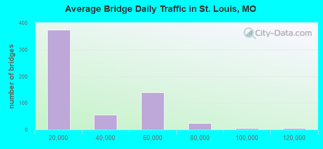
- 13,779,107Total average daily traffic
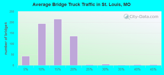
- 1,792,072Total average daily truck traffic
- National Bridge Inventory (NBI) Registered Bridges for St. Louis
- No street view available for this location
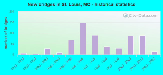
- New bridges - historical statistics
- 1Before 1900
- 11900-1909
- 61910-1919
- 31920-1929
- 281930-1939
- 91940-1949
- 671950-1959
- 1481960-1969
- 901970-1979
- 371980-1989
- 291990-1999
- 872000-2009
- 882010-2019
- 142020-2022
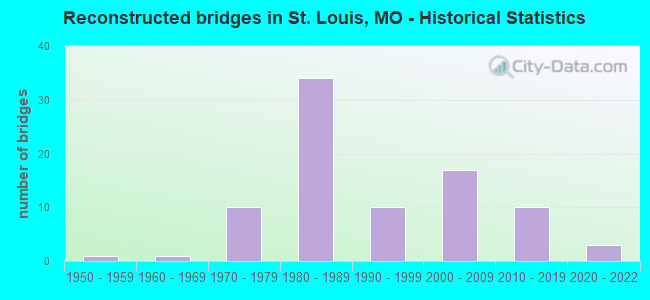
- Reconstructed bridges - Historical Statistics
- 11950-1959
- 11960-1969
- 101970-1979
- 341980-1989
- 101990-1999
- 172000-2009
- 102010-2019
- 32020-2022
- Bridge Condition - Deck
- 2.8%Excellent
- 2.5%Very good
- 37.9%Good
- 34.8%Satisfactory
- 16.0%Fair
- 2.8%Poor
- 3.2%Serious
- Bridge Condition - Superstructure
- 5.9%Excellent
- 6.6%Very good
- 31.8%Good
- 26.6%Satisfactory
- 21.3%Fair
- 4.9%Poor
- 2.8%Serious
- Bridge Condition - Substructure
- 5.2%Excellent
- 14.7%Very good
- 32.2%Good
- 32.5%Satisfactory
- 11.9%Fair
- 2.1%Poor
- 1.4%Serious
- Bridge Condition - Channel
- 3.7%Excellent
- 12.7%Very good
- 14.9%Good
- 38.1%Satisfactory
- 25.4%Fair
- 5.2%Poor
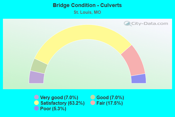
- Bridge Condition - Culverts
- 7.0%Very good
- 7.0%Good
- 63.2%Satisfactory
- 17.5%Fair
- 5.3%Poor
Find on map >> Show street view
Structure Number: 13485, Location: S 18 T 45 N R 7 E (Lat: 38.643069, Lng: -90.270017), Route carried "on" structure: City street , Year Built: 1961, Status: Posted for load, Structure Length: 1.99m (6.53ft), Average Daily Traffic: 3,500 (year 2021), Truck Traffic: 2%, Average Future Daily Traffic: 4,725 (year 2041), Design Load: H 20, Features Intersected: FOREST PARK PKWY, Facility Carried by Structure: GRAND DR
Minimum Vertical Clearance: 30+ m (98+ ft), Kilometerpoint: 0.000, Lanes on structure: 4, Lanes under structure: 4, Owner: City or Municipal Highway Agency, Approaching Roadway Width: 18.3m (60.0ft), Skew: 2 degrees, Material/Design: Concrete continuous, Design/Construction: Slab, Number Of Spans In Main Unit: 1, Length of Maximum Span: 19.5m (64.0ft), Curb or Sidewalk Widths: Left: 3.0m (9.8ft), Right: 3.0m (9.8ft), Curb-To-Curb Width: 17.1m (56.1ft), Out-to-Out Width: 24.4m (80.1ft)
Condition: Deck: Fair, Superstructure: Poor, Substructure: Satisfactory, Operating Rating: 34.2 metric tons, Method Used To Determine Operating Rating: Allowable Stress (AS), Inventory Rating: 23.4 metric tons, Method Used To Determine Inventory Rating: Allowable Stress (AS), Structural Evaluation: Meets minimum limits, Deck Geometry: Somewhat better than minimum adequacy, Underclear: High priority of replacement, Approach Roadway Alignment: Equal to present desirable criteria, Length Of Structure Improvement: 0.27m (0.89ft), Designated Inspection Frequency: Every 12 months, Inspection Date: April 2021, Bridge Improvement Cost: $534,000, Roadway Improvement Cost: $53,000, Total Project Cost: $801,000 ( Estimate for 2022), Deck Structure Type: Concrete Cast-file-Place, Wearing Surface/Protective System: Wearing Surface: Bituminous
Find on map >> Show street view
Structure Number: 13487, Location: S 18 T 45 N R 7 E (Lat: 38.645011, Lng: -90.274900), Route carried "on" structure: City street , Year Built: 1961, Status: Posted for load, Structure Length: 2.63m (8.63ft), Average Daily Traffic: 33,500 (year 2021), Truck Traffic: 5%, Average Future Daily Traffic: 45,225 (year 2041), Design Load: H 20, Features Intersected: FOREST PARK PKWY, Facility Carried by Structure: LINDELL-UNION
Minimum Vertical Clearance: 30+ m (98+ ft), Kilometerpoint: 0.000, Lanes on structure: 8, Lanes under structure: 4, Owner: City or Municipal Highway Agency, Approaching Roadway Width: 37.5m (123.0ft), Skew: 24 degrees, Material/Design: Concrete continuous, Design/Construction: Slab, Number Of Spans In Main Unit: 1, Length of Maximum Span: 25.9m (85.0ft), Curb or Sidewalk Widths: Left: 2.6m (8.5ft), Right: 2.6m (8.5ft), Curb-To-Curb Width: 37.5m (123.0ft), Out-to-Out Width: 103.3m (338.9ft)
Condition: Deck: Serious, Superstructure: Serious, Substructure: Fair, Operating Rating: 34.2 metric tons, Method Used To Determine Operating Rating: Allowable Stress (AS), Inventory Rating: 23.4 metric tons, Method Used To Determine Inventory Rating: Allowable Stress (AS), Structural Evaluation: High priority of corrective action, Deck Geometry: Superior to present desirable criteria, Underclear: High priority of replacement, Approach Roadway Alignment: Equal to present desirable criteria, Length Of Structure Improvement: 0.35m (1.15ft), Designated Inspection Frequency: Every 12 months, Inspection Date: April 2021, Bridge Improvement Cost: $1,297,000, Roadway Improvement Cost: $130,000, Total Project Cost: $1,946,000 ( Estimate for 2022), Deck Structure Type: Concrete Cast-file-Place, Wearing Surface/Protective System: Wearing Surface: Bituminous
Find on map >> Show street view
Structure Number: 13488, Location: S 24 T 45 N R 6 E (Lat: 38.586264, Lng: -90.314097), Route carried "on" structure: City street , Year Built: 1983, Status: Posted for load, Structure Length: 5.30m (17.39ft), Average Daily Traffic: 14,500 (year 2021), Truck Traffic: 5%, Average Future Daily Traffic: 19,575 (year 2041), Design Load: H 20, Features Intersected: CHIPPEWA, Facility Carried by Structure: R. DES PERES DR
Minimum Vertical Clearance: 30+ m (98+ ft), Kilometerpoint: 0.000, Lanes on structure: 4, Lanes under structure: 5, Owner: City or Municipal Highway Agency, Approaching Roadway Width: 15.8m (51.8ft), Material/Design: Prestressed concrete continuous, Design/Construction: Stringer/Multi-beam, Number Of Spans In Main Unit: 3, Length of Maximum Span: 29.3m (96.1ft), Curb or Sidewalk Widths: Left: 2.4m (7.9ft), Right: 0.0m, Curb-To-Curb Width: 15.8m (51.8ft), Out-to-Out Width: 19.6m (64.3ft)
Condition: Deck: Satisfactory, Superstructure: Good, Substructure: Good, Operating Rating: 49.5 metric tons, Method Used To Determine Operating Rating: Allowable Stress (AS), Inventory Rating: 36.0 metric tons, Method Used To Determine Inventory Rating: Allowable Stress (AS), Structural Evaluation: Better than present minimum criteria, Deck Geometry: Meets minimum limits, Underclear: Meets minimum limits, Approach Roadway Alignment: Equal to present desirable criteria, Designated Inspection Frequency: Every 24 months, Inspection Date: March 2021, Deck Structure Type: Concrete Cast-file-Place, Wearing Surface/Protective System: Wearing Surface: Monolithic Concrete, Deck Protection: Epoxy Coated Reinforcing
Find on map >> Show street view
Structure Number: 13491, Location: S 32 T 45 N R 7 E (Lat: 38.590000, Lng: -90.260000), Route carried "on" structure: City street , Year Built: 1936, Status: Posted for load, Structure Length: 1.53m (5.02ft), Average Daily Traffic: 1,000 (year 2021), Truck Traffic: 5%, Average Future Daily Traffic: 1,350 (year 2041), Design Load: H 20, Features Intersected: CHIPPEWA, Facility Carried by Structure: CITY STREET (RAMP)
Minimum Vertical Clearance: 4.72m (15.49ft), Kilometerpoint: 0.000, Lanes on structure: 2, Lanes under structure: 3, Owner: City or Municipal Highway Agency, Approaching Roadway Width: 9.1m (29.9ft), Material/Design: Concrete, Design/Construction: Stringer/Multi-beam, Number Of Spans In Main Unit: 1, Length of Maximum Span: 14.9m (48.9ft), Curb or Sidewalk Widths: Left: 0.5m (1.6ft), Right: 1.5m (4.9ft), Curb-To-Curb Width: 9.1m (29.9ft), Out-to-Out Width: 12.0m (39.4ft)
Condition: Deck: Satisfactory, Superstructure: Satisfactory, Substructure: Satisfactory, Operating Rating: 44.1 metric tons, Method Used To Determine Operating Rating: Allowable Stress (AS), Inventory Rating: 32.4 metric tons, Method Used To Determine Inventory Rating: Allowable Stress (AS), Structural Evaluation: Equal to present minimum criteria, Deck Geometry: Equal to present minimum criteria, Underclear: High priority of corrective action, Approach Roadway Alignment: High priority of corrective action, Designated Inspection Frequency: Every 24 months, Inspection Date: March 2021, Deck Structure Type: Concrete Cast-file-Place, Wearing Surface/Protective System: Wearing Surface: Monolithic Concrete
Find on map >> Show street view
Structure Number: 13492, Location: S 5 T 44 N R 7 E (Lat: 38.587128, Lng: -90.259617), Route carried "on" structure: City street , Year Built: 1939, Status: Posted for load, Structure Length: 1.46m (4.79ft), Average Daily Traffic: 1,500 (year 2021), Truck Traffic: 5%, Average Future Daily Traffic: 2,025 (year 2041), Design Load: H 20, Features Intersected: GRAVOIS AVE, Facility Carried by Structure: BINGHAM
Minimum Vertical Clearance: 4.72m (15.49ft), Kilometerpoint: 0.000, Lanes on structure: 2, Lanes under structure: 4, Owner: City or Municipal Highway Agency, Approaching Roadway Width: 9.1m (29.9ft), Material/Design: Concrete, Design/Construction: Tee Beam, Number Of Spans In Main Unit: 1, Length of Maximum Span: 14.6m (47.9ft), Curb or Sidewalk Widths: Left: 0.5m (1.6ft), Right: 0.5m (1.6ft), Curb-To-Curb Width: 9.1m (29.9ft), Out-to-Out Width: 11.0m (36.1ft)
Condition: Deck: Serious, Superstructure: Poor, Substructure: Serious, Operating Rating: 44.1 metric tons, Method Used To Determine Operating Rating: Allowable Stress (AS), Inventory Rating: 32.4 metric tons, Method Used To Determine Inventory Rating: Allowable Stress (AS), Structural Evaluation: High priority of corrective action, Deck Geometry: Somewhat better than minimum adequacy, Underclear: High priority of replacement, Approach Roadway Alignment: High priority of corrective action, Length Of Structure Improvement: 0.21m (0.69ft), Designated Inspection Frequency: Every 12 months, Inspection Date: March 2021, Bridge Improvement Cost: $228,000, Roadway Improvement Cost: $23,000, Total Project Cost: $341,000 ( Estimate for 2022), Deck Structure Type: Concrete Cast-file-Place, Wearing Surface/Protective System: Wearing Surface: Monolithic Concrete
Find on map >> Show street view
Structure Number: 13677, Location: S 2524 T 46 N R 6 E (Lat: 38.740831, Lng: -90.364681), Route carried "on" structure: Ramp City street , Year Built: 1988, Status: Open, Structure Length: 17.34m (56.89ft), Average Daily Traffic: 12,000 (year 2020), Truck Traffic: 2%, Average Future Daily Traffic: 16,200 (year 2040), Design Load: HS 20, Features Intersected: NO FEATURE, Facility Carried by Structure: RAMP A
Minimum Vertical Clearance: 5.03m (16.50ft), Kilometerpoint: 0.000, Lanes on structure: 1, Owner: City or Municipal Highway Agency, Maintenance Responsibility: Local Agency, Approaching Roadway Width: 5.5m (18.0ft), Material/Design: Steel continuous, Design/Construction: Stringer/Multi-beam, Number Of Spans In Main Unit: 5, Length of Maximum Span: 37.2m (122.0ft), Curb-To-Curb Width: 5.5m (18.0ft), Out-to-Out Width: 6.1m (20.0ft)
Condition: Deck: Good, Superstructure: Satisfactory, Substructure: Very good, Operating Rating: 54.0 metric tons, Method Used To Determine Operating Rating: Allowable Stress (AS), Inventory Rating: 32.4 metric tons, Method Used To Determine Inventory Rating: Allowable Stress (AS), Structural Evaluation: Equal to present minimum criteria, Deck Geometry: Meets minimum limits, Approach Roadway Alignment: Equal to present minimum criteria, Designated Inspection Frequency: Every 24 months, Inspection Date: April 2020, Deck Structure Type: Concrete Cast-file-Place, Wearing Surface/Protective System: Wearing Surface: Monolithic Concrete, Deck Protection: Epoxy Coated Reinforcing
Find on map >> Show street view
Structure Number: 13678, Location: S 2524 T 46 N R 6 E (Lat: 38.741119, Lng: -90.364903), Route carried "on" structure: Ramp City street , Year Built: 1988, Status: Open, Structure Length: 8.66m (28.41ft), Average Daily Traffic: 3,000 (year 2020), Truck Traffic: 2%, Average Future Daily Traffic: 4,050 (year 2040), Design Load: HS 20, Features Intersected: LAMBERT INTL DR, Facility Carried by Structure: RAMP D
Minimum Vertical Clearance: 30+ m (98+ ft), Kilometerpoint: 0.000, Lanes on structure: 1, Lanes under structure: 2, Owner: City or Municipal Highway Agency, Maintenance Responsibility: Local Agency, Approaching Roadway Width: 5.5m (18.0ft), Material/Design: Steel continuous, Design/Construction: Stringer/Multi-beam, Number Of Spans In Main Unit: 3, Length of Maximum Span: 34.4m (112.9ft), Curb-To-Curb Width: 5.5m (18.0ft), Out-to-Out Width: 6.1m (20.0ft)
Condition: Deck: Good, Superstructure: Satisfactory, Substructure: Very good, Operating Rating: 54.0 metric tons, Method Used To Determine Operating Rating: Allowable Stress (AS), Inventory Rating: 32.4 metric tons, Method Used To Determine Inventory Rating: Allowable Stress (AS), Structural Evaluation: Equal to present minimum criteria, Deck Geometry: Meets minimum limits, Underclear: High priority of corrective action, Approach Roadway Alignment: Equal to present minimum criteria, Designated Inspection Frequency: Every 24 months, Inspection Date: April 2020, Deck Structure Type: Concrete Cast-file-Place, Wearing Surface/Protective System: Wearing Surface: Monolithic Concrete, Deck Protection: Epoxy Coated Reinforcing
Find on map >> Show street view
Structure Number: 13679, Location: S 2524 T 46 N R 6 E (Lat: 38.742933, Lng: -90.368144), Route carried "on" structure: City street , Year Built: 1970, Status: Open, Structure Length: 4.39m (14.40ft), Average Daily Traffic: 15,000 (year 2020), Truck Traffic: 2%, Average Future Daily Traffic: 20,250 (year 2040), Features Intersected: BAGGAGE CLAIM DR, Facility Carried by Structure: TICKETING DR
Minimum Vertical Clearance: 30+ m (98+ ft), Kilometerpoint: 0.000, Lanes on structure: 3, Lanes under structure: 6, Owner: City or Municipal Highway Agency, Maintenance Responsibility: Local Agency, Approaching Roadway Width: 9.1m (29.9ft), Skew: 4 degrees, Material/Design: Concrete, Number Of Spans In Main Unit: 2, Length of Maximum Span: 23.2m (76.1ft), Curb or Sidewalk Widths: Left: 2.0m (6.6ft), Right: 2.4m (7.9ft), Curb-To-Curb Width: 9.1m (29.9ft), Out-to-Out Width: 14.0m (45.9ft)
Condition: Deck: Fair, Superstructure: Poor, Substructure: Satisfactory, Operating Rating: 31.5 metric tons, Method Used To Determine Operating Rating: Allowable Stress (AS), Inventory Rating: 28.8 metric tons, Method Used To Determine Inventory Rating: Allowable Stress (AS), Structural Evaluation: Meets minimum limits, Deck Geometry: High priority of replacement, Approach Roadway Alignment: Equal to present minimum criteria, Length Of Structure Improvement: 0.54m (1.77ft), Designated Inspection Frequency: Every 24 months, Inspection Date: April 2020, Bridge Improvement Cost: $871,000, Roadway Improvement Cost: $87,000, Total Project Cost: $1,306,000 ( Estimate for 2022), Deck Structure Type: Concrete Cast-file-Place, Wearing Surface/Protective System: Wearing Surface: Other, Deck Protection: Epoxy Coated Reinforcing
Find on map >> Show street view
Structure Number: 1368, Location: S 7 T 40 N R 15 W (Lat: 38.233617, Lng: -92.621436), Route carried "on" structure: US 54, Year Built: 1966, Status: Open, Structure Length: 6.46m (21.19ft), Average Daily Traffic: 7,434 (year 2021), Truck Traffic: 12%, Average Future Daily Traffic: 13,010 (year 2041), Design Load: H 20, Features Intersected: LITTLE GRAVOIS CR
Minimum Vertical Clearance: 30+ m (98+ ft), Kilometerpoint: 227.715, Lanes on structure: 2, Base Highway Network: Yes, Owner: State Highway Agency, Approaching Roadway Width: 11.6m (38.1ft), Skew: 2 degrees, Material/Design: Steel continuous, Design/Construction: Stringer/Multi-beam, Number Of Spans In Main Unit: 3, Length of Maximum Span: 25.0m (82.0ft), Curb-To-Curb Width: 9.8m (32.2ft), Out-to-Out Width: 10.6m (34.8ft)
Condition: Deck: Satisfactory, Superstructure: Very good, Substructure: Good, Channel: Satisfactory, Operating Rating: 36.9 metric tons, Method Used To Determine Operating Rating: Load Factor (LF), Inventory Rating: 21.6 metric tons, Method Used To Determine Inventory Rating: Load Factor (LF), Structural Evaluation: Somewhat better than minimum adequacy, Deck Geometry: Meets minimum limits, Waterway Adequacy: Equal to present desirable criteria, Approach Roadway Alignment: Equal to present desirable criteria, Designated Inspection Frequency: Every 24 months, Inspection Date: November 2020, Deck Structure Type: Concrete Cast-file-Place, Wearing Surface/Protective System: Wearing Surface: Latex Concrete, Deck Protection: Internally Sealed
Find on map >> Show street view
Structure Number: 1368, Location: S 2524 T 46 N R 6 E (Lat: 38.740428, Lng: -90.365814), Route carried "on" structure: City street , Year Built: 1969, Status: Open, Structure Length: 5.70m (18.70ft), Average Daily Traffic: 10,000 (year 2020), Truck Traffic: 2%, Average Future Daily Traffic: 13,500 (year 2040), Features Intersected: AIRFLIGHT DR, Facility Carried by Structure: COLLECTOR DR
Minimum Vertical Clearance: 30+ m (98+ ft), Kilometerpoint: 0.000, Lanes on structure: 4, Lanes under structure: 4, Owner: City or Municipal Highway Agency, Maintenance Responsibility: Local Agency, Approaching Roadway Width: 19.8m (65.0ft), Material/Design: Concrete continuous, Design/Construction: Slab, Number Of Spans In Main Unit: 3, Length of Maximum Span: 21.6m (70.9ft), Curb or Sidewalk Widths: Left: 0.6m (2.0ft), Right: 0.6m (2.0ft), Curb-To-Curb Width: 19.8m (65.0ft), Out-to-Out Width: 23.5m (77.1ft)
Condition: Deck: Fair, Superstructure: Fair, Substructure: Good, Operating Rating: 67.5 metric tons, Method Used To Determine Operating Rating: Allowable Stress (AS), Inventory Rating: 38.7 metric tons, Method Used To Determine Inventory Rating: Allowable Stress (AS), Structural Evaluation: Somewhat better than minimum adequacy, Deck Geometry: Better than present minimum criteria, Underclear: Meets minimum limits, Approach Roadway Alignment: Equal to present desirable criteria, Designated Inspection Frequency: Every 24 months, Inspection Date: April 2020, Deck Structure Type: Concrete Cast-file-Place, Wearing Surface/Protective System: Wearing Surface: Other
Find on map >> Show street view
Structure Number: 13681, Location: S 2524 T 46 N R 6 E (Lat: 38.743617, Lng: -90.381031), Route carried "on" structure: City street , Year Built: 1992, Status: Open, Structure Length: 3.54m (11.61ft), Average Daily Traffic: 9,300 (year 2020), Truck Traffic: 2%, Average Future Daily Traffic: 12,555 (year 2040), Design Load: HS 20, Features Intersected: COLD WATER CR, Facility Carried by Structure: LAMBERT INTL BLVD
Minimum Vertical Clearance: 30+ m (98+ ft), Kilometerpoint: 0.000, Lanes on structure: 4, Owner: City or Municipal Highway Agency, Maintenance Responsibility: Local Agency, Approaching Roadway Width: 15.8m (51.8ft), Material/Design: Prestressed concrete, Design/Construction: Tee Beam, Number Of Spans In Main Unit: 3, Length of Maximum Span: 13.7m (44.9ft), Curb-To-Curb Width: 15.8m (51.8ft), Out-to-Out Width: 16.7m (54.8ft)
Condition: Deck: Good, Superstructure: Satisfactory, Substructure: Good, Channel: Satisfactory, Operating Rating: 55.8 metric tons, Method Used To Determine Operating Rating: Allowable Stress (AS), Inventory Rating: 35.1 metric tons, Method Used To Determine Inventory Rating: Allowable Stress (AS), Structural Evaluation: Equal to present minimum criteria, Deck Geometry: Meets minimum limits, Waterway Adequacy: Superior to present desirable criteria, Approach Roadway Alignment: Equal to present desirable criteria, Designated Inspection Frequency: Every 24 months, Inspection Date: April 2020, Deck Structure Type: Concrete Cast-file-Place, Wearing Surface/Protective System: Wearing Surface: Monolithic Concrete, Deck Protection: Epoxy Coated Reinforcing
Find on map >> Show street view
Structure Number: 14193, Location: S 1201 T 45 N R 6 E (Lat: 38.642906, Lng: -90.275258), Route carried "on" structure: City street , Year Built: 1935, Year Reconstructed: 1988, Status: Posted for load, Structure Length: 2.32m (7.61ft), Average Daily Traffic: 5,000 (year 2021), Truck Traffic: 5%, Average Future Daily Traffic: 6,750 (year 2041), Features Intersected: RVR DES PERES LAGO, Facility Carried by Structure: GRAND DR
Minimum Vertical Clearance: 30+ m (98+ ft), Kilometerpoint: 0.644, Lanes on structure: 2, Owner: City or Municipal Highway Agency, Maintenance Responsibility: Local Park, Forest, or Reservation Agency, Approaching Roadway Width: 7.7m (25.3ft), Material/Design: Steel, Design/Construction: Arch - Deck, Number Of Spans In Main Unit: 1, Length of Maximum Span: 21.9m (71.9ft), Curb or Sidewalk Widths: Left: 2.3m (7.5ft), Right: 2.3m (7.5ft), Curb-To-Curb Width: 7.7m (25.3ft), Out-to-Out Width: 12.3m (40.4ft)
Condition: Deck: Poor, Superstructure: Poor, Substructure: Fair, Channel: Very good, Operating Rating: 16.2 metric tons, Method Used To Determine Operating Rating: Load Factor (LF), Inventory Rating: 9.9 metric tons, Method Used To Determine Inventory Rating: Load Factor (LF), Structural Evaluation: High priority of replacement, Deck Geometry: High priority of replacement, Waterway Adequacy: Superior to present desirable criteria, Approach Roadway Alignment: Equal to present minimum criteria, Bridge Posting: Required (Relationship of Operating Rating to Maximum Legal Load: > 39.9% below), Length Of Structure Improvement: 0.32m (1.05ft), Designated Inspection Frequency: Every 24 months, Other Special Inspection Frequency: Every 24 months, Inspection Date: April 2021, Other Special Inspection Date: November 2020, Bridge Improvement Cost: $403,000, Roadway Improvement Cost: $40,000, Total Project Cost: $605,000 ( Estimate for 2022), Deck Structure Type: Closed Grating, Wearing Surface/Protective System: Wearing Surface: Monolithic Concrete
Find on map >> Show street view
Structure Number: 14195, Location: S 1201 T 45 N R 6 E (Lat: 38.642128, Lng: -90.288167), Route carried "on" structure: City street , Year Built: 1989, Status: Posted for load, Structure Length: 1.52m (4.99ft), Average Daily Traffic: 1,600 (year 2020), Truck Traffic: 5%, Average Future Daily Traffic: 2,160 (year 2040), Features Intersected: RVR DES PERES LAGO, Facility Carried by Structure: LAGOON DR
Minimum Vertical Clearance: 30+ m (98+ ft), Kilometerpoint: 0.966, Lanes on structure: 2, Owner: City or Municipal Highway Agency, Maintenance Responsibility: Local Park, Forest, or Reservation Agency, Approaching Roadway Width: 13.1m (43.0ft), Skew: 1 degrees, Material/Design: Prestressed concrete, Design/Construction: Stringer/Multi-beam, Number Of Spans In Main Unit: 1, Length of Maximum Span: 14.4m (47.2ft), Curb or Sidewalk Widths: Left: 1.5m (4.9ft), Right: 1.5m (4.9ft), Curb-To-Curb Width: 13.1m (43.0ft), Out-to-Out Width: 16.9m (55.4ft)
Condition: Deck: Good, Superstructure: Good, Substructure: Very good, Channel: Excellent, Operating Rating: 49.5 metric tons, Method Used To Determine Operating Rating: Allowable Stress (AS), Inventory Rating: 32.4 metric tons, Method Used To Determine Inventory Rating: Allowable Stress (AS), Structural Evaluation: Better than present minimum criteria, Deck Geometry: Better than present minimum criteria, Waterway Adequacy: Superior to present desirable criteria, Approach Roadway Alignment: Equal to present desirable criteria, Designated Inspection Frequency: Every 24 months, Inspection Date: April 2020, Deck Structure Type: Concrete Cast-file-Place, Wearing Surface/Protective System: Wearing Surface: Monolithic Concrete, Deck Protection: Epoxy Coated Reinforcing
Find on map >> Show street view
Structure Number: 14196, Location: S 2037 T 45 N R 6 E (Lat: 38.639842, Lng: -90.282144), Route carried "on" structure: City street , Year Built: 1997, Status: Posted for load, Structure Length: 1.16m (3.81ft), Average Daily Traffic: 4,000 (year 2020), Truck Traffic: 5%, Average Future Daily Traffic: 5,400 (year 2040), Features Intersected: RVR DES PERES LAGO, Facility Carried by Structure: MCKINLEY DR
Minimum Vertical Clearance: 30+ m (98+ ft), Kilometerpoint: 1.127, Lanes on structure: 2, Owner: City or Municipal Highway Agency, Maintenance Responsibility: Local Park, Forest, or Reservation Agency, Approaching Roadway Width: 10.1m (33.1ft), Material/Design: Concrete continuous, Design/Construction: Culvert, Number Of Spans In Main Unit: 1, Length of Maximum Span: 11.0m (36.1ft), Curb or Sidewalk Widths: Left: 2.0m (6.6ft), Right: 2.0m (6.6ft)
Condition: Channel: Very good, Culverts: Very good, Operating Rating: 54.0 metric tons, Method Used To Determine Operating Rating: Allowable Stress (AS), Inventory Rating: 32.4 metric tons, Method Used To Determine Inventory Rating: Allowable Stress (AS), Structural Evaluation: Equal to present desirable criteria, Waterway Adequacy: Superior to present desirable criteria, Approach Roadway Alignment: Equal to present desirable criteria, Designated Inspection Frequency: Every 24 months, Inspection Date: April 2020
Find on map >> Show street view
Structure Number: 1458, Location: S 1 T 50 N R 33 W (Lat: 39.173778, Lng: -94.560514), Route carried "on" structure: Ramp State highway , Year Built: 1967, Status: Open, Structure Length: 4.79m (15.72ft), Average Daily Traffic: 15,833 (year 2021), Truck Traffic: 12%, Average Future Daily Traffic: 28,499 (year 2041), Design Load: HS 20, Features Intersected: CST N DAVIDSON RD, Facility Carried by Structure: RP IS29S TO IS35N
Minimum Vertical Clearance: 30+ m (98+ ft), Kilometerpoint: 0.373, Lanes on structure: 1, Lanes under structure: 4, Base Highway Network: Yes, Owner: State Highway Agency, Approaching Roadway Width: 9.1m (29.9ft), Skew: 3 degrees, Material/Design: Concrete continuous, Design/Construction: Slab, Number Of Spans In Main Unit: 3, Length of Maximum Span: 20.7m (67.9ft), Curb-To-Curb Width: 7.3m (24.0ft), Out-to-Out Width: 8.1m (26.6ft)
Condition: Deck: Satisfactory, Superstructure: Satisfactory, Substructure: Satisfactory, Operating Rating: 59.4 metric tons, Method Used To Determine Operating Rating: Load Factor (LF), Inventory Rating: 36.0 metric tons, Method Used To Determine Inventory Rating: Load Factor (LF), Structural Evaluation: Equal to present minimum criteria, Deck Geometry: Better than present minimum criteria, Underclear: Meets minimum limits, Approach Roadway Alignment: Equal to present desirable criteria, Designated Inspection Frequency: Every 24 months, Inspection Date: September 2020, Deck Structure Type: Concrete Cast-file-Place, Wearing Surface/Protective System: Wearing Surface: Monolithic Concrete, Deck Protection: Epoxy Coated Reinforcing
Find on map >> Show street view
Structure Number: 1459, Location: S 1 T 50 N R 33 W (Lat: 39.170203, Lng: -94.557711), Route carried "on" structure: Ramp State highway , Year Built: 1967, Status: Posted for load, Structure Length: 24.93m (81.79ft), Average Daily Traffic: 15,833 (year 2021), Truck Traffic: 12%, Average Future Daily Traffic: 28,499 (year 2041), Design Load: HS 20+Mod, Features Intersected: IS 35, IS 29, Facility Carried by Structure: RP IS29S TO IS35N
Minimum Vertical Clearance: 30+ m (98+ ft), Kilometerpoint: 0.755, Lanes on structure: 1, Lanes under structure: 8, Base Highway Network: Yes, Owner: State Highway Agency, Approaching Roadway Width: 9.1m (29.9ft), Material/Design: Concrete continuous, Design/Construction: Box Beam or Girders - Single/Spread, Number Of Spans In Main Unit: 10, Length of Maximum Span: 29.0m (95.1ft), Curb or Sidewalk Widths: Left: 0.2m (0.7ft), Right: 0.2m (0.7ft), Curb-To-Curb Width: 7.3m (24.0ft), Out-to-Out Width: 8.2m (26.9ft)
Condition: Deck: Fair, Superstructure: Fair, Substructure: Satisfactory, Operating Rating: 58.5 metric tons, Method Used To Determine Operating Rating: Load Factor (LF), Inventory Rating: 35.1 metric tons, Method Used To Determine Inventory Rating: Load Factor (LF), Structural Evaluation: Somewhat better than minimum adequacy, Deck Geometry: Better than present minimum criteria, Underclear: Meets minimum limits, Approach Roadway Alignment: Equal to present desirable criteria, Designated Inspection Frequency: Every 24 months, Inspection Date: May 2021, Deck Structure Type: Concrete Cast-file-Place, Wearing Surface/Protective System: Wearing Surface: Latex Concrete
Find on map >> Show street view
Structure Number: 1844, Location: S 20 T 45 N R 6 E (Lat: 38.618500, Lng: -90.262242), Route carried "on" structure: Interstate 44, Year Built: 1970, Year Reconstructed: 2018, Status: Posted for load, Structure Length: 7.04m (23.10ft), Average Daily Traffic: 42,645 (year 2021), Truck Traffic: 12%, Average Future Daily Traffic: 53,306 (year 2041), Features Intersected: UNION PACIFIC RR
Minimum Vertical Clearance: 30+ m (98+ ft), Kilometerpoint: 461.870, Lanes on structure: 4, Base Highway Network: Yes, Owner: State Highway Agency, Approaching Roadway Width: 21.1m (69.2ft), Skew: 4 degrees, Material/Design: Steel continuous, Design/Construction: Stringer/Multi-beam, Number Of Spans In Main Unit: 3, Length of Maximum Span: 29.0m (95.1ft), Curb-To-Curb Width: 20.3m (66.6ft), Out-to-Out Width: 21.1m (69.2ft)
Condition: Deck: Good, Superstructure: Satisfactory, Substructure: Satisfactory, Operating Rating: 47.7 metric tons, Method Used To Determine Operating Rating: Load Factor (LF), Inventory Rating: 28.8 metric tons, Method Used To Determine Inventory Rating: Load Factor (LF), Structural Evaluation: Equal to present minimum criteria, Deck Geometry: Equal to present minimum criteria, Underclear: Somewhat better than minimum adequacy, Approach Roadway Alignment: Equal to present desirable criteria, Designated Inspection Frequency: Every 24 months, Inspection Date: August 2021, Deck Structure Type: Concrete Cast-file-Place, Wearing Surface/Protective System: Wearing Surface: Monolithic Concrete, Deck Protection: Epoxy Coated Reinforcing
Find on map >> Show street view
Structure Number: 1845, Location: S 20 T 45 N R 6 E (Lat: 38.618714, Lng: -90.261933), Route carried "on" structure: Interstate 44, Year Built: 1970, Year Reconstructed: 2018, Status: Posted for load, Structure Length: 7.04m (23.10ft), Average Daily Traffic: 41,695 (year 2021), Truck Traffic: 12%, Average Future Daily Traffic: 52,119 (year 2041), Features Intersected: UNION PACIFIC RR
Minimum Vertical Clearance: 30+ m (98+ ft), Kilometerpoint: 9.724, Lanes on structure: 4, Base Highway Network: Yes, Owner: State Highway Agency, Approaching Roadway Width: 20.3m (66.6ft), Skew: 4 degrees, Material/Design: Steel continuous, Design/Construction: Stringer/Multi-beam, Number Of Spans In Main Unit: 3, Length of Maximum Span: 29.0m (95.1ft), Curb-To-Curb Width: 20.3m (66.6ft), Out-to-Out Width: 21.1m (69.2ft)
Condition: Deck: Good, Superstructure: Good, Substructure: Satisfactory, Operating Rating: 47.7 metric tons, Method Used To Determine Operating Rating: Load Factor (LF), Inventory Rating: 28.8 metric tons, Method Used To Determine Inventory Rating: Load Factor (LF), Structural Evaluation: Equal to present minimum criteria, Deck Geometry: Equal to present minimum criteria, Underclear: Somewhat better than minimum adequacy, Approach Roadway Alignment: Equal to present desirable criteria, Designated Inspection Frequency: Every 24 months, Inspection Date: August 2021, Deck Structure Type: Concrete Cast-file-Place, Wearing Surface/Protective System: Wearing Surface: Monolithic Concrete, Deck Protection: Epoxy Coated Reinforcing
Find on map >> Show street view
Structure Number: 1846, Location: S 20 T 45 N R 6 E (Lat: 38.618467, Lng: -90.260122), Route carried "on" structure: Interstate 44, Year Built: 1970, Year Reconstructed: 2018, Status: Open, Structure Length: 6.10m (20.01ft), Average Daily Traffic: 42,645 (year 2021), Truck Traffic: 12%, Average Future Daily Traffic: 53,306 (year 2041), Features Intersected: CST VANDEVENTER AVE
Minimum Vertical Clearance: 30+ m (98+ ft), Kilometerpoint: 462.053, Lanes on structure: 4, Lanes under structure: 5, Base Highway Network: Yes, Owner: State Highway Agency, Approaching Roadway Width: 20.3m (66.6ft), Skew: 33 degrees, Material/Design: Steel continuous, Design/Construction: Stringer/Multi-beam, Number Of Spans In Main Unit: 3, Length of Maximum Span: 29.1m (95.5ft), Curb-To-Curb Width: 20.3m (66.6ft), Out-to-Out Width: 21.1m (69.2ft)
Condition: Deck: Good, Superstructure: Good, Substructure: Satisfactory, Operating Rating: 72.9 metric tons, Method Used To Determine Operating Rating: Load Factor (LF), Inventory Rating: 43.2 metric tons, Method Used To Determine Inventory Rating: Load Factor (LF), Structural Evaluation: Equal to present minimum criteria, Deck Geometry: Equal to present minimum criteria, Underclear: Meets minimum limits, Approach Roadway Alignment: Equal to present desirable criteria, Designated Inspection Frequency: Every 24 months, Inspection Date: August 2021, Deck Structure Type: Concrete Cast-file-Place, Wearing Surface/Protective System: Wearing Surface: Monolithic Concrete, Deck Protection: Epoxy Coated Reinforcing
Find on map >> Show street view
Structure Number: 1847, Location: S 20 T 45 N R 6 E (Lat: 38.618622, Lng: -90.259958), Route carried "on" structure: Interstate 44, Year Built: 1970, Year Reconstructed: 2018, Status: Open, Structure Length: 6.10m (20.01ft), Average Daily Traffic: 47,119 (year 2021), Truck Traffic: 12%, Average Future Daily Traffic: 58,899 (year 2041), Features Intersected: CST VANDEVENTER AVE
Minimum Vertical Clearance: 30+ m (98+ ft), Kilometerpoint: 9.560, Lanes on structure: 4, Lanes under structure: 5, Base Highway Network: Yes, Owner: State Highway Agency, Approaching Roadway Width: 20.3m (66.6ft), Skew: 3 degrees, Material/Design: Steel continuous, Design/Construction: Stringer/Multi-beam, Number Of Spans In Main Unit: 3, Length of Maximum Span: 29.1m (95.5ft), Curb-To-Curb Width: 20.3m (66.6ft), Out-to-Out Width: 21.1m (69.2ft)
Condition: Deck: Good, Superstructure: Very good, Substructure: Satisfactory, Operating Rating: 72.9 metric tons, Method Used To Determine Operating Rating: Load Factor (LF), Inventory Rating: 43.2 metric tons, Method Used To Determine Inventory Rating: Load Factor (LF), Structural Evaluation: Equal to present minimum criteria, Deck Geometry: Equal to present minimum criteria, Underclear: Meets minimum limits, Approach Roadway Alignment: Equal to present desirable criteria, Designated Inspection Frequency: Every 24 months, Inspection Date: August 2021, Deck Structure Type: Concrete Precast Panels, Wearing Surface/Protective System: Wearing Surface: Monolithic Concrete, Deck Protection: Epoxy Coated Reinforcing
Find on map >> Show street view
Structure Number: 1848, Location: S 20 T 45 N R 7 E (Lat: 38.618111, Lng: -90.256078), Route carried "on" structure: Interstate 44, Year Built: 1970, Year Reconstructed: 2018, Status: Open, Structure Length: 4.94m (16.21ft), Average Daily Traffic: 43,302 (year 2021), Truck Traffic: 12%, Average Future Daily Traffic: 54,128 (year 2041), Design Load: HS 20+Mod, Features Intersected: CST TOWER GROVE AVE
Minimum Vertical Clearance: 30+ m (98+ ft), Kilometerpoint: 462.423, Lanes on structure: 5, Lanes under structure: 2, Base Highway Network: Yes, Owner: State Highway Agency, Approaching Roadway Width: 24.4m (80.1ft), Material/Design: Concrete continuous, Design/Construction: Slab, Number Of Spans In Main Unit: 4, Length of Maximum Span: 15.1m (49.5ft), Curb-To-Curb Width: 24.1m (79.1ft), Out-to-Out Width: 24.9m (81.7ft)
Condition: Deck: Satisfactory, Superstructure: Satisfactory, Substructure: Good, Operating Rating: 59.4 metric tons, Method Used To Determine Operating Rating: Load Factor (LF), Inventory Rating: 36.0 metric tons, Method Used To Determine Inventory Rating: Load Factor (LF), Structural Evaluation: Equal to present minimum criteria, Deck Geometry: Equal to present minimum criteria, Underclear: Meets minimum limits, Approach Roadway Alignment: Equal to present desirable criteria, Designated Inspection Frequency: Every 24 months, Inspection Date: August 2021, Deck Structure Type: Concrete Cast-file-Place, Wearing Surface/Protective System: Wearing Surface: Latex Concrete, Deck Protection: Epoxy Coated Reinforcing
Find on map >> Show street view
Structure Number: 1849, Location: S 20 T 45 N R 7 E (Lat: 38.618308, Lng: -90.256047), Route carried "on" structure: Interstate 44, Year Built: 1970, Year Reconstructed: 2018, Status: Open, Structure Length: 4.94m (16.21ft), Average Daily Traffic: 47,119 (year 2021), Truck Traffic: 12%, Average Future Daily Traffic: 58,899 (year 2041), Design Load: HS 20+Mod, Features Intersected: CST TOWER GROVE AVE
Minimum Vertical Clearance: 30+ m (98+ ft), Kilometerpoint: 9.223, Lanes on structure: 5, Lanes under structure: 2, Base Highway Network: Yes, Owner: State Highway Agency, Approaching Roadway Width: 23.9m (78.4ft), Material/Design: Concrete continuous, Design/Construction: Slab, Number Of Spans In Main Unit: 4, Length of Maximum Span: 15.1m (49.5ft), Curb-To-Curb Width: 23.9m (78.4ft), Out-to-Out Width: 24.5m (80.4ft)
Condition: Deck: Satisfactory, Superstructure: Satisfactory, Substructure: Good, Operating Rating: 59.4 metric tons, Method Used To Determine Operating Rating: Load Factor (LF), Inventory Rating: 36.0 metric tons, Method Used To Determine Inventory Rating: Load Factor (LF), Structural Evaluation: Equal to present minimum criteria, Deck Geometry: Equal to present minimum criteria, Underclear: Somewhat better than minimum adequacy, Approach Roadway Alignment: Equal to present desirable criteria, Designated Inspection Frequency: Every 24 months, Inspection Date: August 2021, Deck Structure Type: Concrete Cast-file-Place, Wearing Surface/Protective System: Wearing Surface: Latex Concrete, Deck Protection: Epoxy Coated Reinforcing
Find on map >> Show street view
Structure Number: 1937, Location: S 28 T 45 N R 7 E (Lat: 38.615222, Lng: -90.232617), Route carried "on" structure: City street , Year Built: 1970, Year Reconstructed: 2014, Status: Posted for load, Structure Length: 7.41m (24.31ft), Average Daily Traffic: 3,219 (year 2021), Truck Traffic: 3%, Average Future Daily Traffic: 4,507 (year 2041), Design Load: HS 20, Features Intersected: IS 44, Facility Carried by Structure: COMPTON AVE S
Minimum Vertical Clearance: 30+ m (98+ ft), Kilometerpoint: 3.246, Lanes on structure: 2, Lanes under structure: 9, Owner: State Highway Agency, Approaching Roadway Width: 7.3m (24.0ft), Skew: 1 degrees, Material/Design: Steel continuous, Design/Construction: Stringer/Multi-beam, Number Of Spans In Main Unit: 4, Length of Maximum Span: 30.8m (101.0ft), Curb-To-Curb Width: 11.0m (36.1ft), Out-to-Out Width: 14.5m (47.6ft)
Condition: Deck: Good, Superstructure: Fair, Substructure: Satisfactory, Operating Rating: 49.5 metric tons, Method Used To Determine Operating Rating: Load Factor (LF), Inventory Rating: 29.7 metric tons, Method Used To Determine Inventory Rating: Load Factor (LF), Structural Evaluation: Somewhat better than minimum adequacy, Deck Geometry: Somewhat better than minimum adequacy, Underclear: Meets minimum limits, Approach Roadway Alignment: Equal to present desirable criteria, Designated Inspection Frequency: Every 24 months, Inspection Date: August 2021, Deck Structure Type: Concrete Cast-file-Place, Wearing Surface/Protective System: Wearing Surface: Monolithic Concrete, Membrane: Built-up, Deck Protection: Other Coated Reinforcing
Find on map >> Show street view
Structure Number: 1938, Location: S 28 T 45 N R 7 E (Lat: 38.614292, Lng: -90.228111), Route carried "on" structure: City street , Year Built: 1970, Year Reconstructed: 1984, Status: Open, Structure Length: 6.86m (22.51ft), Average Daily Traffic: 2,131 (year 2021), Truck Traffic: 4%, Average Future Daily Traffic: 3,197 (year 2041), Design Load: HS 20, Features Intersected: IS 44, Facility Carried by Structure: NEBRASKA AVE S
Minimum Vertical Clearance: 30+ m (98+ ft), Kilometerpoint: 0.538, Lanes on structure: 2, Lanes under structure: 8, Owner: State Highway Agency, Approaching Roadway Width: 11.0m (36.1ft), Material/Design: Concrete continuous, Design/Construction: Box Beam or Girders - Single/Spread, Number Of Spans In Main Unit: 4, Length of Maximum Span: 22.6m (74.1ft), Curb or Sidewalk Widths: Left: 1.5m (4.9ft), Right: 1.5m (4.9ft), Curb-To-Curb Width: 11.0m (36.1ft), Out-to-Out Width: 14.5m (47.6ft)
Condition: Deck: Fair, Superstructure: Fair, Substructure: Satisfactory, Operating Rating: 69.3 metric tons, Method Used To Determine Operating Rating: Allowable Stress (AS), Inventory Rating: 45.0 metric tons, Method Used To Determine Inventory Rating: Allowable Stress (AS), Structural Evaluation: Somewhat better than minimum adequacy, Deck Geometry: Somewhat better than minimum adequacy, Underclear: Meets minimum limits, Approach Roadway Alignment: Equal to present desirable criteria, Designated Inspection Frequency: Every 24 months, Inspection Date: August 2021, Deck Structure Type: Concrete Cast-file-Place, Wearing Surface/Protective System: Wearing Surface: Low Slump Concrete, Membrane: Built-up
Find on map >> Show street view
Structure Number: 199, Location: S 26 T 45 N R 6 E (Lat: 38.608536, Lng: -90.304256), Route carried "on" structure: City street , Year Built: 1971, Year Reconstructed: 2009, Status: Open, Structure Length: 7.01m (23.00ft), Average Daily Traffic: 7,585 (year 2021), Truck Traffic: 5%, Average Future Daily Traffic: 10,619 (year 2041), Design Load: HS 20, Features Intersected: IS 44, Facility Carried by Structure: ARSENAL ST E
Minimum Vertical Clearance: 30+ m (98+ ft), Kilometerpoint: 0.624, Lanes on structure: 4, Lanes under structure: 8, Owner: State Highway Agency, Approaching Roadway Width: 13.4m (44.0ft), Skew: 2 degrees, Material/Design: Steel continuous, Design/Construction: Stringer/Multi-beam, Number Of Spans In Main Unit: 4, Length of Maximum Span: 24.1m (79.1ft), Curb or Sidewalk Widths: Left: 1.8m (5.9ft), Right: 1.8m (5.9ft), Curb-To-Curb Width: 13.4m (44.0ft), Out-to-Out Width: 17.7m (58.1ft)
Condition: Deck: Good, Superstructure: Satisfactory, Substructure: Fair, Operating Rating: 56.7 metric tons, Method Used To Determine Operating Rating: Load Factor (LF), Inventory Rating: 34.2 metric tons, Method Used To Determine Inventory Rating: Load Factor (LF), Structural Evaluation: Somewhat better than minimum adequacy, Deck Geometry: High priority of replacement, Underclear: Meets minimum limits, Approach Roadway Alignment: Equal to present desirable criteria, Length Of Structure Improvement: 0.80m (2.62ft), Designated Inspection Frequency: Every 24 months, Other Special Inspection Frequency: Every 24 months, Inspection Date: August 2021, Other Special Inspection Date: December 2020, Bridge Improvement Cost: $1,069,000, Roadway Improvement Cost: $107,000, Total Project Cost: $1,603,000 ( Estimate for 2022), Deck Structure Type: Concrete Cast-file-Place, Wearing Surface/Protective System: Wearing Surface: Monolithic Concrete
Find on map >> Show street view
Structure Number: 2, Location: S 26 T 45 N R 6 E (Lat: 38.605900, Lng: -90.307306), Route carried "on" structure: City street , Year Built: 1971, Year Reconstructed: 2011, Status: Open, Structure Length: 9.94m (32.61ft), Average Daily Traffic: 9,309 (year 2021), Truck Traffic: 4%, Average Future Daily Traffic: 13,033 (year 2041), Design Load: HS 20, Features Intersected: IS 44, Facility Carried by Structure: JAMIESON AVE S
Minimum Vertical Clearance: 30+ m (98+ ft), Kilometerpoint: 0.267, Lanes on structure: 3, Lanes under structure: 8, Base Highway Network: Yes, Owner: State Highway Agency, Approaching Roadway Width: 11.0m (36.1ft), Skew: 4 degrees, Material/Design: Steel continuous, Design/Construction: Stringer/Multi-beam, Number Of Spans In Main Unit: 4, Length of Maximum Span: 34.4m (112.9ft), Curb or Sidewalk Widths: Left: 1.5m (4.9ft), Right: 0.0m, Curb-To-Curb Width: 11.1m (36.4ft), Out-to-Out Width: 13.4m (44.0ft)
Condition: Deck: Good, Superstructure: Satisfactory, Substructure: Fair, Operating Rating: 58.5 metric tons, Method Used To Determine Operating Rating: Load Factor (LF), Inventory Rating: 35.1 metric tons, Method Used To Determine Inventory Rating: Load Factor (LF), Structural Evaluation: Somewhat better than minimum adequacy, Deck Geometry: High priority of replacement, Underclear: Meets minimum limits, Approach Roadway Alignment: Equal to present desirable criteria, Length Of Structure Improvement: 1.09m (3.58ft), Designated Inspection Frequency: Every 24 months, Other Special Inspection Frequency: Every 24 months, Inspection Date: August 2021, Other Special Inspection Date: December 2020, Bridge Improvement Cost: $1,154,000, Roadway Improvement Cost: $115,000, Total Project Cost: $1,731,000 ( Estimate for 2022), Deck Structure Type: Concrete Cast-file-Place, Wearing Surface/Protective System: Wearing Surface: Monolithic Concrete
Find on map >> Show street view
Structure Number: 2001, Location: S 26 T 45 N R 6 E (Lat: 38.606011, Lng: -90.307164), Route carried "on" structure: City street , Year Built: 1971, Year Reconstructed: 2011, Status: Open, Structure Length: 9.94m (32.61ft), Average Daily Traffic: 5,936 (year 2021), Truck Traffic: 5%, Average Future Daily Traffic: 8,310 (year 2041), Design Load: HS 20, Features Intersected: IS 44, Facility Carried by Structure: JAMIESON AVE N
Minimum Vertical Clearance: 30+ m (98+ ft), Kilometerpoint: 4.321, Lanes on structure: 3, Lanes under structure: 8, Base Highway Network: Yes, Owner: State Highway Agency, Approaching Roadway Width: 11.0m (36.1ft), Skew: 4 degrees, Material/Design: Steel continuous, Design/Construction: Stringer/Multi-beam, Number Of Spans In Main Unit: 4, Length of Maximum Span: 34.4m (112.9ft), Curb or Sidewalk Widths: Left: 0.0m, Right: 1.5m (4.9ft), Curb-To-Curb Width: 11.1m (36.4ft), Out-to-Out Width: 13.4m (44.0ft)
Condition: Deck: Good, Superstructure: Fair, Substructure: Fair, Operating Rating: 60.3 metric tons, Method Used To Determine Operating Rating: Load Factor (LF), Inventory Rating: 36.0 metric tons, Method Used To Determine Inventory Rating: Load Factor (LF), Structural Evaluation: Somewhat better than minimum adequacy, Deck Geometry: High priority of replacement, Underclear: Meets minimum limits, Approach Roadway Alignment: Equal to present desirable criteria, Length Of Structure Improvement: 1.09m (3.58ft), Designated Inspection Frequency: Every 24 months, Other Special Inspection Frequency: Every 24 months, Inspection Date: August 2021, Other Special Inspection Date: December 2020, Bridge Improvement Cost: $1,154,000, Roadway Improvement Cost: $115,000, Total Project Cost: $1,731,000 ( Estimate for 2022), Deck Structure Type: Concrete Cast-file-Place, Wearing Surface/Protective System: Wearing Surface: Monolithic Concrete
Find on map >> Show street view
Structure Number: 2002, Location: S 25 T 45 N R 6 E (Lat: 38.613275, Lng: -90.301200), Route carried "on" structure: Interstate 44, Year Built: 1971, Status: Open, Structure Length: 5.00m (16.40ft), Average Daily Traffic: 41,918 (year 2021), Truck Traffic: 12%, Average Future Daily Traffic: 52,398 (year 2041), Design Load: HS 20+Mod, Features Intersected: CST SOUTHWEST AVE
Minimum Vertical Clearance: 30+ m (98+ ft), Kilometerpoint: 458.342, Lanes on structure: 5, Lanes under structure: 2, Base Highway Network: Yes, Owner: State Highway Agency, Approaching Roadway Width: 19.5m (64.0ft), Material/Design: Concrete continuous, Design/Construction: Slab, Number Of Spans In Main Unit: 3, Length of Maximum Span: 20.4m (66.9ft), Curb-To-Curb Width: 24.1m (79.1ft), Out-to-Out Width: 25.1m (82.3ft)
Condition: Deck: Satisfactory, Superstructure: Satisfactory, Substructure: Satisfactory, Operating Rating: 69.3 metric tons, Method Used To Determine Operating Rating: Load Factor (LF), Inventory Rating: 41.4 metric tons, Method Used To Determine Inventory Rating: Load Factor (LF), Structural Evaluation: Equal to present minimum criteria, Deck Geometry: Equal to present minimum criteria, Underclear: Somewhat better than minimum adequacy, Approach Roadway Alignment: Equal to present minimum criteria, Designated Inspection Frequency: Every 24 months, Inspection Date: August 2021, Deck Structure Type: Concrete Cast-file-Place, Wearing Surface/Protective System: Wearing Surface: Other, Membrane: Built-up
Find on map >> Show street view
Structure Number: 2003, Location: S 25 T 45 N R 6 E (Lat: 38.613400, Lng: -90.301417), Route carried "on" structure: Interstate 44, Year Built: 1971, Status: Open, Structure Length: 5.58m (18.31ft), Average Daily Traffic: 39,318 (year 2021), Truck Traffic: 12%, Average Future Daily Traffic: 49,148 (year 2041), Design Load: HS 20+Mod, Features Intersected: CST SOUTHWEST AVE
Minimum Vertical Clearance: 30+ m (98+ ft), Kilometerpoint: 13.322, Lanes on structure: 4, Lanes under structure: 2, Base Highway Network: Yes, Owner: State Highway Agency, Approaching Roadway Width: 19.5m (64.0ft), Skew: 1 degrees, Material/Design: Concrete continuous, Design/Construction: Slab, Number Of Spans In Main Unit: 3, Length of Maximum Span: 20.4m (66.9ft), Curb-To-Curb Width: 20.0m (65.6ft), Out-to-Out Width: 20.8m (68.2ft)
Condition: Deck: Satisfactory, Superstructure: Satisfactory, Substructure: Satisfactory, Operating Rating: 69.3 metric tons, Method Used To Determine Operating Rating: Load Factor (LF), Inventory Rating: 41.4 metric tons, Method Used To Determine Inventory Rating: Load Factor (LF), Structural Evaluation: Equal to present minimum criteria, Deck Geometry: Equal to present minimum criteria, Underclear: Somewhat better than minimum adequacy, Approach Roadway Alignment: Equal to present minimum criteria, Designated Inspection Frequency: Every 24 months, Inspection Date: August 2021, Deck Structure Type: Concrete Cast-file-Place, Wearing Surface/Protective System: Wearing Surface: Other, Membrane: Built-up
Find on map >> Show street view
Structure Number: 2004, Location: S 19 T 45 N R 7 E (Lat: 38.619153, Lng: -90.276672), Route carried "on" structure: City street , Year Built: 1969, Year Reconstructed: 1984, Status: Posted for load, Structure Length: 5.58m (18.31ft), Average Daily Traffic: 4,122 (year 2021), Truck Traffic: 5%, Average Future Daily Traffic: 6,183 (year 2041), Design Load: HS 20, Features Intersected: IS 44, Facility Carried by Structure: MACKLIND AVE S
Minimum Vertical Clearance: 30+ m (98+ ft), Kilometerpoint: 1.167, Lanes on structure: 2, Lanes under structure: 8, Owner: State Highway Agency, Approaching Roadway Width: 11.0m (36.1ft), Material/Design: Concrete continuous, Design/Construction: Slab, Number Of Spans In Main Unit: 3, Length of Maximum Span: 22.6m (74.1ft), Curb or Sidewalk Widths: Left: 1.5m (4.9ft), Right: 1.5m (4.9ft), Curb-To-Curb Width: 11.0m (36.1ft), Out-to-Out Width: 14.5m (47.6ft)
Condition: Deck: Fair, Superstructure: Fair, Substructure: Satisfactory, Operating Rating: 48.6 metric tons, Method Used To Determine Operating Rating: Allowable Stress (AS), Inventory Rating: 32.4 metric tons, Method Used To Determine Inventory Rating: Allowable Stress (AS), Structural Evaluation: Somewhat better than minimum adequacy, Deck Geometry: Somewhat better than minimum adequacy, Underclear: Meets minimum limits, Approach Roadway Alignment: Equal to present desirable criteria, Designated Inspection Frequency: Every 24 months, Inspection Date: August 2021, Deck Structure Type: Concrete Cast-file-Place, Wearing Surface/Protective System: Wearing Surface: Bituminous, Membrane: Built-up
Find on map >> Show street view
Structure Number: 2006, Location: S 19 T 45 N R 7 E (Lat: 38.619122, Lng: -90.280989), Route carried "on" structure: Interstate 44, Year Built: 1969, Year Reconstructed: 2008, Status: Posted for load, Structure Length: 3.80m (12.47ft), Average Daily Traffic: 41,506 (year 2021), Truck Traffic: 12%, Average Future Daily Traffic: 51,883 (year 2041), Design Load: HS 20+Mod, Features Intersected: CST SUBLETTE AVE
Minimum Vertical Clearance: 30+ m (98+ ft), Kilometerpoint: 460.251, Lanes on structure: 5, Lanes under structure: 2, Base Highway Network: Yes, Owner: State Highway Agency, Approaching Roadway Width: 19.5m (64.0ft), Skew: 1 degrees, Material/Design: Concrete continuous, Design/Construction: Slab, Number Of Spans In Main Unit: 3, Length of Maximum Span: 16.8m (55.1ft), Curb-To-Curb Width: 20.4m (66.9ft), Out-to-Out Width: 20.8m (68.2ft)
Condition: Deck: Satisfactory, Superstructure: Satisfactory, Substructure: Satisfactory, Operating Rating: 53.1 metric tons, Method Used To Determine Operating Rating: Load Factor (LF), Inventory Rating: 31.5 metric tons, Method Used To Determine Inventory Rating: Load Factor (LF), Structural Evaluation: Equal to present minimum criteria, Deck Geometry: High priority of corrective action, Underclear: Meets minimum limits, Approach Roadway Alignment: Equal to present desirable criteria, Designated Inspection Frequency: Every 24 months, Inspection Date: August 2021, Deck Structure Type: Concrete Cast-file-Place, Wearing Surface/Protective System: Wearing Surface: Other, Membrane: Built-up
Find on map >> Show street view
Structure Number: 2007, Location: S 19 T 45 N R 7 E (Lat: 38.619314, Lng: -90.280947), Route carried "on" structure: Interstate 44, Year Built: 1969, Status: Posted for load, Structure Length: 3.81m (12.50ft), Average Daily Traffic: 44,823 (year 2021), Truck Traffic: 12%, Average Future Daily Traffic: 56,029 (year 2041), Design Load: HS 20+Mod, Features Intersected: CST SUBLETTE AVE
Minimum Vertical Clearance: 30+ m (98+ ft), Kilometerpoint: 11.401, Lanes on structure: 4, Lanes under structure: 2, Base Highway Network: Yes, Owner: State Highway Agency, Approaching Roadway Width: 19.5m (64.0ft), Skew: 1 degrees, Material/Design: Concrete continuous, Design/Construction: Slab, Number Of Spans In Main Unit: 3, Length of Maximum Span: 16.8m (55.1ft), Curb-To-Curb Width: 20.4m (66.9ft), Out-to-Out Width: 20.8m (68.2ft)
Condition: Deck: Satisfactory, Superstructure: Satisfactory, Substructure: Satisfactory, Operating Rating: 53.1 metric tons, Method Used To Determine Operating Rating: Load Factor (LF), Inventory Rating: 31.5 metric tons, Method Used To Determine Inventory Rating: Load Factor (LF), Structural Evaluation: Equal to present minimum criteria, Deck Geometry: Equal to present minimum criteria, Underclear: Meets minimum limits, Approach Roadway Alignment: Equal to present desirable criteria, Designated Inspection Frequency: Every 24 months, Inspection Date: August 2021, Deck Structure Type: Concrete Cast-file-Place, Wearing Surface/Protective System: Wearing Surface: Other, Membrane: Built-up, Deck Protection: Other
Find on map >> Show street view
Structure Number: 2041, Location: S 24 T 45 N R 6 E (Lat: 38.618578, Lng: -90.288156), Route carried "on" structure: Interstate 44, Year Built: 1969, Status: Posted for load, Structure Length: 5.73m (18.80ft), Average Daily Traffic: 43,637 (year 2021), Truck Traffic: 12%, Average Future Daily Traffic: 54,546 (year 2041), Design Load: HS 20+Mod, Features Intersected: CST HAMPTON AVE
Minimum Vertical Clearance: 30+ m (98+ ft), Kilometerpoint: 459.612, Lanes on structure: 4, Lanes under structure: 8, Base Highway Network: Yes, Owner: State Highway Agency, Approaching Roadway Width: 19.5m (64.0ft), Material/Design: Steel continuous, Design/Construction: Stringer/Multi-beam, Number Of Spans In Main Unit: 2, Length of Maximum Span: 28.3m (92.8ft), Curb-To-Curb Width: 20.3m (66.6ft), Out-to-Out Width: 21.2m (69.6ft)
Condition: Deck: Satisfactory, Superstructure: Fair, Substructure: Fair, Operating Rating: 49.5 metric tons, Method Used To Determine Operating Rating: Load Factor (LF), Inventory Rating: 29.7 metric tons, Method Used To Determine Inventory Rating: Load Factor (LF), Structural Evaluation: Somewhat better than minimum adequacy, Deck Geometry: Equal to present minimum criteria, Underclear: Equal to present minimum criteria, Approach Roadway Alignment: Equal to present desirable criteria, Designated Inspection Frequency: Every 24 months, Inspection Date: August 2021, Deck Structure Type: Concrete Cast-file-Place, Wearing Surface/Protective System: Wearing Surface: Latex Concrete, Membrane: Built-up
Find on map >> Show street view
Structure Number: 2042, Location: S 24 T 45 N R 6 E (Lat: 38.618736, Lng: -90.288233), Route carried "on" structure: Interstate 44, Year Built: 1969, Status: Posted for load, Structure Length: 5.73m (18.80ft), Average Daily Traffic: 44,823 (year 2021), Truck Traffic: 12%, Average Future Daily Traffic: 56,029 (year 2041), Design Load: HS 20+Mod, Features Intersected: CST HAMPTON AVE
Minimum Vertical Clearance: 30+ m (98+ ft), Kilometerpoint: 12.030, Lanes on structure: 4, Lanes under structure: 8, Base Highway Network: Yes, Owner: State Highway Agency, Approaching Roadway Width: 19.5m (64.0ft), Skew: 20 degrees, Material/Design: Steel continuous, Design/Construction: Stringer/Multi-beam, Number Of Spans In Main Unit: 2, Length of Maximum Span: 28.3m (92.8ft), Curb-To-Curb Width: 20.3m (66.6ft), Out-to-Out Width: 21.2m (69.6ft)
Condition: Deck: Satisfactory, Superstructure: Fair, Substructure: Fair, Operating Rating: 49.5 metric tons, Method Used To Determine Operating Rating: Load Factor (LF), Inventory Rating: 29.7 metric tons, Method Used To Determine Inventory Rating: Load Factor (LF), Structural Evaluation: Somewhat better than minimum adequacy, Deck Geometry: Equal to present minimum criteria, Underclear: Equal to present minimum criteria, Approach Roadway Alignment: Equal to present desirable criteria, Designated Inspection Frequency: Every 24 months, Inspection Date: August 2021, Deck Structure Type: Concrete Cast-file-Place, Wearing Surface/Protective System: Wearing Surface: Latex Concrete, Membrane: Built-up
Find on map >> Show street view
Structure Number: 2065, Location: S 35 T 45 N R 6 E (Lat: 38.599622, Lng: -90.315972), Route carried "on" structure: Interstate 44, Year Built: 1971, Status: Posted for load, Structure Length: 18.23m (59.81ft), Average Daily Traffic: 43,533 (year 2021), Truck Traffic: 12%, Average Future Daily Traffic: 54,416 (year 2041), Design Load: HS 20+Mod, Features Intersected: CST WABASH AVE, RIVER DE
Minimum Vertical Clearance: 30+ m (98+ ft), Kilometerpoint: 456.197, Lanes on structure: 4, Lanes under structure: 4, Base Highway Network: Yes, Owner: State Highway Agency, Approaching Roadway Width: 19.5m (64.0ft), Skew: 2 degrees, Material/Design: Steel continuous, Design/Construction: Stringer/Multi-beam, Number Of Spans In Main Unit: 4, Number Of Approach Spans: 4, Length of Maximum Span: 36.3m (119.1ft), Curb-To-Curb Width: 20.3m (66.6ft), Out-to-Out Width: 21.1m (69.2ft)
Condition: Deck: Good, Superstructure: Satisfactory, Substructure: Good, Channel: Good, Operating Rating: 40.5 metric tons, Method Used To Determine Operating Rating: Load Factor (LF), Inventory Rating: 24.3 metric tons, Method Used To Determine Inventory Rating: Load Factor (LF), Structural Evaluation: Equal to present minimum criteria, Deck Geometry: Equal to present minimum criteria, Underclear: Meets minimum limits, Waterway Adequacy: Equal to present desirable criteria, Approach Roadway Alignment: Equal to present desirable criteria, Designated Inspection Frequency: Every 24 months, Inspection Date: August 2020, Deck Structure Type: Concrete Cast-file-Place, Wearing Surface/Protective System: Wearing Surface: Epoxy Overlay, Deck Protection: Epoxy Coated Reinforcing
Find on map >> Show street view
Structure Number: 2066, Location: S 35 T 45 N R 6 E (Lat: 38.599847, Lng: -90.315939), Route carried "on" structure: Interstate 44, Year Built: 1971, Status: Posted for load, Structure Length: 12.10m (39.70ft), Average Daily Traffic: 45,865 (year 2021), Truck Traffic: 12%, Average Future Daily Traffic: 57,331 (year 2041), Design Load: HS 20+Mod, Features Intersected: CST ELLENDALE AVE, RIVER
Minimum Vertical Clearance: 30+ m (98+ ft), Kilometerpoint: 15.323, Lanes on structure: 4, Lanes under structure: 4, Base Highway Network: Yes, Owner: State Highway Agency, Approaching Roadway Width: 19.5m (64.0ft), Skew: 2 degrees, Material/Design: Steel continuous, Design/Construction: Stringer/Multi-beam, Number Of Spans In Main Unit: 4, Length of Maximum Span: 35.1m (115.2ft), Curb-To-Curb Width: 20.3m (66.6ft), Out-to-Out Width: 21.1m (69.2ft)
Condition: Deck: Good, Superstructure: Good, Substructure: Good, Channel: Good, Operating Rating: 40.5 metric tons, Method Used To Determine Operating Rating: Load Factor (LF), Inventory Rating: 24.3 metric tons, Method Used To Determine Inventory Rating: Load Factor (LF), Structural Evaluation: Equal to present minimum criteria, Deck Geometry: Equal to present minimum criteria, Underclear: Meets minimum limits, Waterway Adequacy: Equal to present desirable criteria, Approach Roadway Alignment: Equal to present desirable criteria, Designated Inspection Frequency: Every 24 months, Inspection Date: August 2020, Deck Structure Type: Concrete Cast-file-Place, Wearing Surface/Protective System: Wearing Surface: Epoxy Overlay
Find on map >> Show street view
Structure Number: 24, Location: S 23 T 45 N R 6 E (Lat: 38.629314, Lng: -90.323975), Route carried "on" structure: Interstate 64, Year Built: 1957, Status: Open, Structure Length: 0.63m (2.07ft), Average Daily Traffic: 163,129 (year 2021), Truck Traffic: 12%, Average Future Daily Traffic: 203,911 (year 2041), Design Load: HS 20, Features Intersected: E FK DEER CR
Minimum Vertical Clearance: 30+ m (98+ ft), Kilometerpoint: 52.848, Lanes on structure: 6, Base Highway Network: Yes, Owner: State Highway Agency, Approaching Roadway Width: 32.9m (107.9ft), Skew: 20 degrees, Material/Design: Concrete continuous, Design/Construction: Culvert, Number Of Spans In Main Unit: 2, Length of Maximum Span: 3.0m (9.8ft)
Condition: Channel: Good, Culverts: Satisfactory, Structural Evaluation: Equal to present minimum criteria, Waterway Adequacy: Equal to present desirable criteria, Approach Roadway Alignment: Equal to present desirable criteria, Designated Inspection Frequency: Every 24 months, Inspection Date: November 2021
Find on map >> Show street view
Structure Number: 248, Location: S 24 T 60 N R 11 W (Lat: 39.987264, Lng: -92.068525), Route carried "on" structure: State highway 156, Year Built: 1972, Status: Open, Structure Length: 6.40m (21.00ft), Average Daily Traffic: 298 (year 2021), Truck Traffic: 49%, Average Future Daily Traffic: 432 (year 2041), Design Load: H 15, Features Intersected: LIT FABIUS RVR
Minimum Vertical Clearance: 30+ m (98+ ft), Kilometerpoint: 63.547, Lanes on structure: 2, Owner: State Highway Agency, Approaching Roadway Width: 7.3m (24.0ft), Skew: 4 degrees, Material/Design: Steel continuous, Design/Construction: Stringer/Multi-beam, Number Of Spans In Main Unit: 3, Length of Maximum Span: 23.8m (78.1ft), Curb-To-Curb Width: 8.5m (27.9ft), Out-to-Out Width: 9.4m (30.8ft)
Condition: Deck: Good, Superstructure: Very good, Substructure: Good, Channel: Satisfactory, Operating Rating: 40.5 metric tons, Method Used To Determine Operating Rating: Load Factor (LF), Inventory Rating: 24.3 metric tons, Method Used To Determine Inventory Rating: Load Factor (LF), Structural Evaluation: Equal to present minimum criteria, Deck Geometry: Equal to present minimum criteria, Waterway Adequacy: Equal to present minimum criteria, Approach Roadway Alignment: Equal to present desirable criteria, Designated Inspection Frequency: Every 24 months, Inspection Date: November 2021, Deck Structure Type: Concrete Cast-file-Place, Wearing Surface/Protective System: Wearing Surface: Bituminous, Membrane: Built-up, Deck Protection: Internally Sealed
Find on map >> Show street view
Structure Number: 2481, Location: S 26 T 64 N R 12 W (Lat: 40.353331, Lng: -92.245994), Route carried "on" structure: State highway T, Year Built: 1972, Status: Open, Structure Length: 6.95m (22.80ft), Average Daily Traffic: 239 (year 2021), Truck Traffic: 16%, Average Future Daily Traffic: 347 (year 2041), Design Load: H 15, Features Intersected: N FK MID FABIUS RV
Minimum Vertical Clearance: 30+ m (98+ ft), Kilometerpoint: 13.483, Lanes on structure: 2, Owner: State Highway Agency, Approaching Roadway Width: 6.1m (20.0ft), Skew: 3 degrees, Material/Design: Steel continuous, Design/Construction: Stringer/Multi-beam, Number Of Spans In Main Unit: 3, Length of Maximum Span: 26.8m (87.9ft), Curb-To-Curb Width: 8.5m (27.9ft), Out-to-Out Width: 9.4m (30.8ft)
Condition: Deck: Satisfactory, Superstructure: Very good, Substructure: Very good, Channel: Satisfactory, Operating Rating: 29.7 metric tons, Method Used To Determine Operating Rating: Allowable Stress (AS), Inventory Rating: 18.0 metric tons, Method Used To Determine Inventory Rating: Allowable Stress (AS), Structural Evaluation: Somewhat better than minimum adequacy, Deck Geometry: Equal to present minimum criteria, Waterway Adequacy: Equal to present minimum criteria, Approach Roadway Alignment: Equal to present minimum criteria, Designated Inspection Frequency: Every 24 months, Inspection Date: October 2020, Deck Structure Type: Concrete Cast-file-Place, Wearing Surface/Protective System: Wearing Surface: Monolithic Concrete, Deck Protection: Internally Sealed