Bridge Statistics for St. Louis, Missouri (MO)
Condition, Traffic, Stress, Structural Evaluation, Project Costs
- National Bridge Inventory (NBI) Statistics
- 608Number of bridges
- 12,736ft / 3,882mTotal length
- $695,294,000Total costs
- 13,779,107Total average daily traffic
- 1,792,072Total average daily truck traffic
- National Bridge Inventory (NBI) Registered Bridges for St. Louis
- No street view available for this location
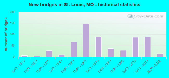
- New bridges - historical statistics
- 1Before 1900
- 11900-1909
- 61910-1919
- 31920-1929
- 281930-1939
- 91940-1949
- 671950-1959
- 1481960-1969
- 901970-1979
- 371980-1989
- 291990-1999
- 872000-2009
- 882010-2019
- 142020-2022
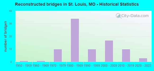
- Reconstructed bridges - Historical Statistics
- 11950-1959
- 11960-1969
- 101970-1979
- 341980-1989
- 101990-1999
- 172000-2009
- 102010-2019
- 32020-2022
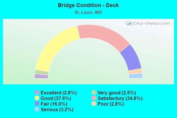
- Bridge Condition - Deck
- 2.8%Excellent
- 2.5%Very good
- 37.9%Good
- 34.8%Satisfactory
- 16.0%Fair
- 2.8%Poor
- 3.2%Serious
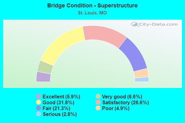
- Bridge Condition - Superstructure
- 5.9%Excellent
- 6.6%Very good
- 31.8%Good
- 26.6%Satisfactory
- 21.3%Fair
- 4.9%Poor
- 2.8%Serious
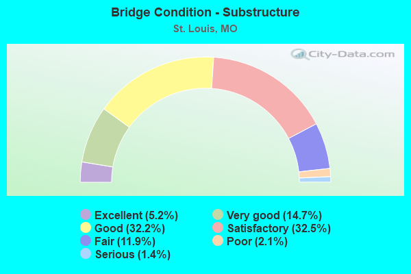
- Bridge Condition - Substructure
- 5.2%Excellent
- 14.7%Very good
- 32.2%Good
- 32.5%Satisfactory
- 11.9%Fair
- 2.1%Poor
- 1.4%Serious
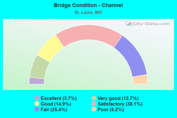
- Bridge Condition - Channel
- 3.7%Excellent
- 12.7%Very good
- 14.9%Good
- 38.1%Satisfactory
- 25.4%Fair
- 5.2%Poor
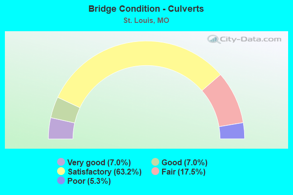
- Bridge Condition - Culverts
- 7.0%Very good
- 7.0%Good
- 63.2%Satisfactory
- 17.5%Fair
- 5.3%Poor
Find on map >> Show street view
Structure Number: 6397, Location: S 16 T 45 N R 7 E (Lat: 38.631467, Lng: -90.234828), Route carried "under" structure: Interstate 64, Year Built: 1954, Structure Length: 0. m, Average Daily Traffic: 103,894 (year 2021), Truck Traffic: 12%, Features Intersected: IS 64, Facility Carried by Structure: GRAND BLVD S
Minimum Vertical Clearance: 4.62m (15.16ft), Kilometerpoint: 60.874, Lanes on structure: 5, Lanes under structure: 3, Material/Design: Concrete, Design/Construction: Tee Beam, Length of Maximum Span: 26.8m (87.9ft)
Find on map >> Show street view
Structure Number: 6418, Location: S 16 T 45 N R 7 E (Lat: 38.631886, Lng: -90.244628), Route carried "under" structure: City street , Year Built: 1956, Structure Length: 0. m, Average Daily Traffic: 16,002 (year 2021), Truck Traffic: 5%, Features Intersected: CST VANDEVENTER AVE, Facility Carried by Structure: IS 64 E
Minimum Vertical Clearance: 5.79m (19.00ft), Kilometerpoint: 4.485, Lanes on structure: 3, Lanes under structure: 5, Material/Design: Steel continuous, Design/Construction: Stringer/Multi-beam, Length of Maximum Span: 39.0m (128.0ft)
Find on map >> Show street view
Structure Number: 6418, Location: S 16 T 45 N R 7 E (Lat: 38.631886, Lng: -90.244628), Route carried "under" structure: City street , Year Built: 1956, Structure Length: 0. m, Average Daily Traffic: 6,811 (year 2021), Truck Traffic: 10%, Features Intersected: CST CLAYTON AVE, Facility Carried by Structure: IS 64 E
Minimum Vertical Clearance: 8.15m (26.74ft), Kilometerpoint: 3.005, Lanes on structure: 3, Lanes under structure: 2, Material/Design: Steel continuous, Design/Construction: Stringer/Multi-beam, Length of Maximum Span: 39.0m (128.0ft)
Find on map >> Show street view
Structure Number: 642, Location: S 20 T 45 N R 7 E (Lat: 38.630922, Lng: -90.250831), Route carried "under" structure: Ramp State highway , Year Built: 1956, Structure Length: 0. m, Average Daily Traffic: 6,048 (year 2021), Truck Traffic: 18%, Features Intersected: RP VANDEVENTER AVE TO IS, Facility Carried by Structure: IS 64 E
Minimum Vertical Clearance: 4.70m (15.42ft), Kilometerpoint: 0.454, Lanes on structure: 3, Lanes under structure: 1, Material/Design: Steel, Design/Construction: Stringer/Multi-beam, Length of Maximum Span: 20.7m (67.9ft)
Find on map >> Show street view
Structure Number: 6531, Location: S 30 T 46 N R 7 E (Lat: 38.632889, Lng: -90.185922), Route carried "under" structure: City street , Year Built: 1958, Structure Length: 0. m, Average Daily Traffic: 5,008 (year 2021), Truck Traffic: 5%, Features Intersected: CST CARR ST, Facility Carried by Structure: IS 44 E
Minimum Vertical Clearance: 4.27m (14.01ft), Kilometerpoint: 0.072, Lanes on structure: 6, Lanes under structure: 2, Material/Design: Steel continuous, Design/Construction: Stringer/Multi-beam, Length of Maximum Span: 40.5m (132.9ft)
Find on map >> Show street view
Structure Number: 6531, Location: S 30 T 46 N R 7 E (Lat: 38.632889, Lng: -90.185922), Route carried "under" structure: City street , Year Built: 1958, Structure Length: 0. m, Average Daily Traffic: 14,232 (year 2021), Truck Traffic: 10%, Features Intersected: CST CONVENTION PL, Facility Carried by Structure: IS 44 E
Minimum Vertical Clearance: 4.37m (14.34ft), Kilometerpoint: 0.051, Lanes on structure: 6, Lanes under structure: 2, Material/Design: Steel continuous, Design/Construction: Stringer/Multi-beam, Length of Maximum Span: 40.5m (132.9ft)
Find on map >> Show street view
Structure Number: 6531, Location: S 30 T 46 N R 7 E (Lat: 38.632889, Lng: -90.185922), Route carried "under" structure: State highway 799, Year Built: 1958, Structure Length: 0. m, Average Daily Traffic: 2,935 (year 2021), Truck Traffic: 5%, Features Intersected: MO 799, Facility Carried by Structure: IS 44 E
Minimum Vertical Clearance: 4.52m (14.83ft), Kilometerpoint: 0.404, Lanes on structure: 6, Lanes under structure: 1, Material/Design: Steel continuous, Design/Construction: Stringer/Multi-beam, Length of Maximum Span: 40.5m (132.9ft)
Find on map >> Show street view
Structure Number: 6531, Location: S 30 T 46 N R 7 E (Lat: 38.632889, Lng: -90.185922), Route carried "under" structure: Ramp State highway , Year Built: 1958, Structure Length: 0. m, Average Daily Traffic: 1,174 (year 2021), Truck Traffic: 10%, Features Intersected: CO RP IS44E TO WASHINGTO, Facility Carried by Structure: IS 44 E
Minimum Vertical Clearance: 4.27m (14.01ft), Kilometerpoint: 0.031, Lanes on structure: 6, Lanes under structure: 4, Material/Design: Steel continuous, Design/Construction: Stringer/Multi-beam, Length of Maximum Span: 40.5m (132.9ft)
Find on map >> Show street view
Structure Number: 673, Location: S 18 T 44 N R 7 E (Lat: 38.551911, Lng: -90.280103), Route carried "under" structure: Interstate 55, Year Built: 1962, Structure Length: 0. m, Average Daily Traffic: 50,390 (year 2021), Truck Traffic: 12%, Features Intersected: IS 55, Facility Carried by Structure: WEBER RD E
Minimum Vertical Clearance: 5.18m (16.99ft), Kilometerpoint: 324.702, Lanes on structure: 3, Lanes under structure: 4, Material/Design: Concrete continuous, Design/Construction: Box Beam or Girders - Single/Spread, Length of Maximum Span: 23.2m (76.1ft)
Find on map >> Show street view
Structure Number: 673, Location: S 18 T 44 N R 7 E (Lat: 38.551911, Lng: -90.280103), Route carried "under" structure: Interstate 55, Year Built: 1962, Structure Length: 0. m, Average Daily Traffic: 54,917 (year 2021), Truck Traffic: 12%, Features Intersected: IS 55, Facility Carried by Structure: WEBER RD E
Minimum Vertical Clearance: 4.60m (15.09ft), Kilometerpoint: 12.955, Lanes on structure: 3, Lanes under structure: 4, Material/Design: Concrete continuous, Design/Construction: Box Beam or Girders - Single/Spread, Length of Maximum Span: 23.2m (76.1ft)
Find on map >> Show street view
Structure Number: 823, Location: S 114 T 47 N R 7 E (Lat: 38.766925, Lng: -90.182397), Route carried "under" structure: State highway H, Year Built: 1962, Structure Length: 0. m, Average Daily Traffic: 3,966 (year 2021), Truck Traffic: 19%, Features Intersected: RT H, Facility Carried by Structure: IS 270 E
Minimum Vertical Clearance: 5.13m (16.83ft), Kilometerpoint: 0.797, Lanes on structure: 2, Lanes under structure: 3, Material/Design: Steel continuous, Design/Construction: Stringer/Multi-beam, Length of Maximum Span: 19.2m (63.0ft)
Find on map >> Show street view
Structure Number: 823, Location: S 114 T 47 N R 7 E (Lat: 38.766925, Lng: -90.182397), Route carried "under" structure: State highway H, Year Built: 1962, Structure Length: 0. m, Average Daily Traffic: 4,387 (year 2021), Truck Traffic: 19%, Features Intersected: RT H, Facility Carried by Structure: IS 270 E
Minimum Vertical Clearance: 4.95m (16.24ft), Kilometerpoint: 12.081, Lanes on structure: 2, Lanes under structure: 3, Material/Design: Steel continuous, Design/Construction: Stringer/Multi-beam, Length of Maximum Span: 19.2m (63.0ft)
Find on map >> Show street view
Structure Number: 824, Location: S 114 T 47 N R 7 E (Lat: 38.767117, Lng: -90.182367), Route carried "under" structure: State highway H, Year Built: 1962, Structure Length: 0. m, Average Daily Traffic: 4,387 (year 2021), Truck Traffic: 19%, Features Intersected: RT H, Facility Carried by Structure: IS 270 W
Minimum Vertical Clearance: 4.52m (14.83ft), Kilometerpoint: 12.102, Lanes on structure: 2, Lanes under structure: 3, Material/Design: Steel continuous, Design/Construction: Stringer/Multi-beam, Length of Maximum Span: 19.2m (63.0ft)
Find on map >> Show street view
Structure Number: 824, Location: S 114 T 47 N R 7 E (Lat: 38.767117, Lng: -90.182367), Route carried "under" structure: State highway H, Year Built: 1962, Structure Length: 0. m, Average Daily Traffic: 3,966 (year 2021), Truck Traffic: 19%, Features Intersected: RT H, Facility Carried by Structure: IS 270 W
Minimum Vertical Clearance: 4.55m (14.93ft), Kilometerpoint: 0.774, Lanes on structure: 2, Lanes under structure: 3, Material/Design: Steel continuous, Design/Construction: Stringer/Multi-beam, Length of Maximum Span: 19.2m (63.0ft)
Find on map >> Show street view
Structure Number: 852, Location: S 18 T 44 N R 7 E (Lat: 38.553139, Lng: -90.270794), Route carried "under" structure: City street , Year Built: 1963, Structure Length: 0. m, Average Daily Traffic: 8,539 (year 2021), Truck Traffic: 10%, Features Intersected: CST GERMANIA AVE, Facility Carried by Structure: IS 55 S
Minimum Vertical Clearance: 5.84m (19.16ft), Kilometerpoint: 2.609, Lanes on structure: 8, Lanes under structure: 4, Material/Design: Steel, Design/Construction: Stringer/Multi-beam, Length of Maximum Span: 30.2m (99.1ft)
Find on map >> Show street view
Structure Number: 852, Location: S 18 T 44 N R 7 E (Lat: 38.553139, Lng: -90.270794), Route carried "under" structure: City street , Year Built: 1963, Structure Length: 0. m, Average Daily Traffic: 13,754 (year 2021), Truck Traffic: 10%, Features Intersected: CST CARONDELET BLVD, Facility Carried by Structure: IS 55 S
Minimum Vertical Clearance: 4.39m (14.40ft), Kilometerpoint: 1.221, Lanes on structure: 8, Lanes under structure: 4, Material/Design: Steel, Design/Construction: Stringer/Multi-beam, Length of Maximum Span: 30.2m (99.1ft)
Find on map >> Show street view
Structure Number: 866, Location: S 18 T 44 N R 7 E (Lat: 38.553547, Lng: -90.265967), Route carried "under" structure: City street , Year Built: 1963, Structure Length: 0. m, Average Daily Traffic: 700 (year 2021), Truck Traffic: 5%, Features Intersected: CST KOELN AVE, Facility Carried by Structure: IS 55 S
Minimum Vertical Clearance: 5.28m (17.32ft), Kilometerpoint: 0.600, Lanes on structure: 10, Lanes under structure: 2, Material/Design: Concrete continuous, Design/Construction: Slab, Length of Maximum Span: 20.4m (66.9ft)
Find on map >> Show street view
Structure Number: 868, Location: S 17 T 44 N R 7 E (Lat: 38.556728, Lng: -90.259272), Route carried "under" structure: Interstate 55, Year Built: 1963, Structure Length: 0. m, Average Daily Traffic: 47,083 (year 2021), Truck Traffic: 12%, Features Intersected: IS 55, Facility Carried by Structure: LOUGHBOROUGH AVE E
Minimum Vertical Clearance: 4.62m (15.16ft), Kilometerpoint: 10.981, Lanes on structure: 2, Lanes under structure: 4, Material/Design: Concrete continuous, Design/Construction: Slab, Length of Maximum Span: 20.7m (67.9ft)
Find on map >> Show street view
Structure Number: 868, Location: S 17 T 44 N R 7 E (Lat: 38.556728, Lng: -90.259272), Route carried "under" structure: Interstate 55, Year Built: 1963, Structure Length: 0. m, Average Daily Traffic: 49,342 (year 2021), Truck Traffic: 12%, Features Intersected: IS 55, Facility Carried by Structure: LOUGHBOROUGH AVE E
Minimum Vertical Clearance: 4.57m (14.99ft), Kilometerpoint: 326.680, Lanes on structure: 2, Lanes under structure: 4, Material/Design: Concrete continuous, Design/Construction: Slab, Length of Maximum Span: 20.7m (67.9ft)
Find on map >> Show street view
Structure Number: 869, Location: S 17 T 44 N R 7 E (Lat: 38.556794, Lng: -90.259228), Route carried "under" structure: Interstate 55, Year Built: 1963, Structure Length: 0. m, Average Daily Traffic: 47,083 (year 2021), Truck Traffic: 12%, Features Intersected: IS 55, Facility Carried by Structure: LOUGHBOROUGH AVE W
Minimum Vertical Clearance: 4.78m (15.68ft), Kilometerpoint: 10.981, Lanes on structure: 2, Lanes under structure: 4, Material/Design: Concrete continuous, Design/Construction: Slab, Length of Maximum Span: 20.7m (67.9ft)
Find on map >> Show street view
Structure Number: 869, Location: S 17 T 44 N R 7 E (Lat: 38.556794, Lng: -90.259228), Route carried "under" structure: Interstate 55, Year Built: 1963, Structure Length: 0. m, Average Daily Traffic: 49,342 (year 2021), Truck Traffic: 12%, Features Intersected: IS 55, Facility Carried by Structure: LOUGHBOROUGH AVE W
Minimum Vertical Clearance: 4.78m (15.68ft), Kilometerpoint: 326.680, Lanes on structure: 2, Lanes under structure: 4, Material/Design: Concrete continuous, Design/Construction: Slab, Length of Maximum Span: 20.7m (67.9ft)
Find on map >> Show street view
Structure Number: 871, Location: S 8 T 44 N R 7 E (Lat: 38.562861, Lng: -90.246458), Route carried "under" structure: City street , Year Built: 1963, Structure Length: 0. m, Average Daily Traffic: 3,712 (year 2021), Truck Traffic: 4%, Features Intersected: CST VIRGINIA AVE, Facility Carried by Structure: IS 55 S
Minimum Vertical Clearance: 4.65m (15.26ft), Kilometerpoint: 2.234, Lanes on structure: 4, Lanes under structure: 3, Material/Design: Concrete continuous, Design/Construction: Slab, Length of Maximum Span: 20.0m (65.6ft)
Find on map >> Show street view
Structure Number: 872, Location: S 8 T 44 N R 7 E (Lat: 38.562717, Lng: -90.246397), Route carried "under" structure: City street , Year Built: 1963, Structure Length: 0. m, Average Daily Traffic: 3,712 (year 2021), Truck Traffic: 4%, Features Intersected: CST VIRGINIA AVE, Facility Carried by Structure: IS 55 N
Minimum Vertical Clearance: 4.62m (15.16ft), Kilometerpoint: 2.251, Lanes on structure: 4, Lanes under structure: 3, Material/Design: Concrete continuous, Design/Construction: Slab, Length of Maximum Span: 20.0m (65.6ft)
Find on map >> Show street view
Structure Number: 873, Location: S 9 T 44 N R 7 E (Lat: 38.563461, Lng: -90.244747), Route carried "under" structure: City street , Year Built: 1963, Structure Length: 0. m, Average Daily Traffic: 7,877 (year 2021), Truck Traffic: 5%, Features Intersected: CST BATES ST, Facility Carried by Structure: IS 55 S
Minimum Vertical Clearance: 4.65m (15.26ft), Kilometerpoint: 3.080, Lanes on structure: 4, Lanes under structure: 2, Material/Design: Concrete continuous, Design/Construction: Box Beam or Girders - Single/Spread, Length of Maximum Span: 22.3m (73.2ft)
Find on map >> Show street view
Structure Number: 874, Location: S 9 T 44 N R 7 E (Lat: 38.563339, Lng: -90.244556), Route carried "under" structure: City street , Year Built: 1963, Structure Length: 0. m, Average Daily Traffic: 7,877 (year 2021), Truck Traffic: 5%, Features Intersected: CST BATES ST, Facility Carried by Structure: IS 55 N
Minimum Vertical Clearance: 4.62m (15.16ft), Kilometerpoint: 3.103, Lanes on structure: 4, Lanes under structure: 2, Material/Design: Concrete continuous, Design/Construction: Box Beam or Girders - Single/Spread, Length of Maximum Span: 22.3m (73.2ft)
Find on map >> Show street view
Structure Number: 876, Location: S 4 T 44 N R 7 E (Lat: 38.574244, Lng: -90.233836), Route carried "under" structure: City street , Year Built: 1963, Structure Length: 0. m, Average Daily Traffic: 12,054 (year 2021), Truck Traffic: 5%, Features Intersected: CST BROADWAY ST, Facility Carried by Structure: IS 55 S
Minimum Vertical Clearance: 4.64m (15.22ft), Kilometerpoint: 3.906, Lanes on structure: 4, Lanes under structure: 4, Material/Design: Concrete continuous, Design/Construction: Slab, Length of Maximum Span: 15.8m (51.8ft)
Find on map >> Show street view
Structure Number: 877, Location: S 4 T 44 N R 7 E (Lat: 38.574033, Lng: -90.233797), Route carried "under" structure: City street , Year Built: 1963, Structure Length: 0. m, Average Daily Traffic: 10,205 (year 2021), Truck Traffic: 5%, Features Intersected: CST BROADWAY ST, Facility Carried by Structure: IS 55 N
Minimum Vertical Clearance: 4.57m (14.99ft), Kilometerpoint: 3.916, Lanes on structure: 4, Lanes under structure: 4, Material/Design: Concrete continuous, Design/Construction: Slab, Length of Maximum Span: 15.8m (51.8ft)
Find on map >> Show street view
Structure Number: 878, Location: S 3 T 44 N R 7 E (Lat: 38.580469, Lng: -90.225950), Route carried "under" structure: City street , Year Built: 1965, Structure Length: 0. m, Average Daily Traffic: 2,680 (year 2020), Truck Traffic: 5%, Features Intersected: CST GASCONADE ST, Facility Carried by Structure: IS 55 S
Minimum Vertical Clearance: 4.57m (14.99ft), Kilometerpoint: 0.369, Lanes on structure: 4, Lanes under structure: 2, Material/Design: Concrete continuous, Design/Construction: Slab, Length of Maximum Span: 21.3m (69.9ft)
Find on map >> Show street view
Structure Number: 879, Location: S 3 T 44 N R 7 E (Lat: 38.580417, Lng: -90.225619), Route carried "under" structure: City street , Year Built: 1965, Structure Length: 0. m, Average Daily Traffic: 2,680 (year 2020), Truck Traffic: 5%, Features Intersected: CST GASCONADE ST, Facility Carried by Structure: IS 55 N
Minimum Vertical Clearance: 4.57m (14.99ft), Kilometerpoint: 0.396, Lanes on structure: 4, Lanes under structure: 2, Material/Design: Concrete continuous, Design/Construction: Slab, Length of Maximum Span: 21.3m (69.9ft)
Find on map >> Show street view
Structure Number: 88, Location: S 34 T 45 N R 7 E (Lat: 38.588319, Lng: -90.214500), Route carried "under" structure: City street , Year Built: 1965, Structure Length: 0. m, Average Daily Traffic: 2,843 (year 2021), Truck Traffic: 5%, Features Intersected: CST POTOMAC ST, Facility Carried by Structure: IS 55 S
Minimum Vertical Clearance: 5.92m (19.42ft), Kilometerpoint: 0.307, Lanes on structure: 4, Lanes under structure: 2, Material/Design: Concrete continuous, Design/Construction: Slab, Length of Maximum Span: 18.7m (61.4ft)
Find on map >> Show street view
Structure Number: 881, Location: S 34 T 45 N R 7 E (Lat: 38.588189, Lng: -90.214325), Route carried "under" structure: City street , Year Built: 1965, Structure Length: 0. m, Average Daily Traffic: 2,843 (year 2021), Truck Traffic: 5%, Features Intersected: CST POTOMAC ST, Facility Carried by Structure: IS 55 N
Minimum Vertical Clearance: 5.97m (19.59ft), Kilometerpoint: 0.332, Lanes on structure: 4, Lanes under structure: 2, Material/Design: Concrete continuous, Design/Construction: Slab, Length of Maximum Span: 19.9m (65.3ft)
Find on map >> Show street view
Structure Number: 882, Location: S 344 T 45 N R 7 E (Lat: 38.590211, Lng: -90.214131), Route carried "under" structure: City street , Year Built: 1965, Structure Length: 0. m, Average Daily Traffic: 300 (year 2021), Truck Traffic: 10%, Features Intersected: CST 2ND ST, Facility Carried by Structure: IS 55 S
Minimum Vertical Clearance: 6.15m (20.18ft), Kilometerpoint: 0.571, Lanes on structure: 4, Lanes under structure: 2, Material/Design: Steel continuous, Design/Construction: Stringer/Multi-beam, Length of Maximum Span: 24.0m (78.7ft)
Find on map >> Show street view
Structure Number: 883, Location: S 34 T 45 N R 7 E (Lat: 38.590278, Lng: -90.213889), Route carried "under" structure: City street , Year Built: 1965, Structure Length: 0. m, Average Daily Traffic: 300 (year 2021), Truck Traffic: 10%, Features Intersected: CST 2ND ST, Facility Carried by Structure: IS 55 N
Minimum Vertical Clearance: 6.15m (20.18ft), Kilometerpoint: 0.547, Lanes on structure: 4, Lanes under structure: 2, Material/Design: Steel continuous, Design/Construction: Stringer/Multi-beam, Length of Maximum Span: 24.8m (81.4ft)
Find on map >> Show street view
Structure Number: 884, Location: S 34 T 45 N R 7 E (Lat: 38.591650, Lng: -90.214464), Route carried "under" structure: City street , Year Built: 1965, Structure Length: 0. m, Average Daily Traffic: 5,262 (year 2021), Truck Traffic: 5%, Features Intersected: CST BROADWAY ST, Facility Carried by Structure: IS 55 S
Minimum Vertical Clearance: 4.73m (15.52ft), Kilometerpoint: 8.917, Lanes on structure: 4, Lanes under structure: 3, Material/Design: Concrete continuous, Design/Construction: Slab, Length of Maximum Span: 15.2m (49.9ft)
Find on map >> Show street view
Structure Number: 885, Location: S 34 T 45 N R 7 E (Lat: 38.591742, Lng: -90.214258), Route carried "under" structure: City street , Year Built: 1965, Structure Length: 0. m, Average Daily Traffic: 8,460 (year 2021), Truck Traffic: 5%, Features Intersected: CST BROADWAY ST, Facility Carried by Structure: IS 55 N
Minimum Vertical Clearance: 4.75m (15.58ft), Kilometerpoint: 8.940, Lanes on structure: 4, Lanes under structure: 3, Material/Design: Concrete continuous, Design/Construction: Slab, Length of Maximum Span: 15.2m (49.9ft)
Find on map >> Show street view
Structure Number: 886, Location: S 34 T 45 N R 7 E (Lat: 38.593878, Lng: -90.215628), Route carried "under" structure: Interstate 55, Year Built: 1964, Structure Length: 0. m, Average Daily Traffic: 44,651 (year 2021), Truck Traffic: 12%, Features Intersected: IS 55, Facility Carried by Structure: UTAH ST E
Minimum Vertical Clearance: 5.00m (16.40ft), Kilometerpoint: 4.917, Lanes on structure: 2, Lanes under structure: 5, Material/Design: Concrete continuous, Design/Construction: Box Beam or Girders - Single/Spread, Length of Maximum Span: 17.7m (58.1ft)
Find on map >> Show street view
Structure Number: 886, Location: S 34 T 45 N R 7 E (Lat: 38.593878, Lng: -90.215628), Route carried "under" structure: Interstate 55, Year Built: 1964, Structure Length: 0. m, Average Daily Traffic: 48,458 (year 2021), Truck Traffic: 12%, Features Intersected: IS 55, Facility Carried by Structure: UTAH ST E
Minimum Vertical Clearance: 4.42m (14.50ft), Kilometerpoint: 332.744, Lanes on structure: 2, Lanes under structure: 5, Material/Design: Concrete continuous, Design/Construction: Box Beam or Girders - Single/Spread, Length of Maximum Span: 17.7m (58.1ft)
Find on map >> Show street view
Structure Number: 887, Location: S 34 T 45 N R 7 E (Lat: 38.596594, Lng: -90.216122), Route carried "under" structure: Interstate 55, Year Built: 1964, Structure Length: 0. m, Average Daily Traffic: 52,823 (year 2021), Truck Traffic: 12%, Features Intersected: IS 55, Facility Carried by Structure: ARSENAL ST E
Minimum Vertical Clearance: 4.42m (14.50ft), Kilometerpoint: 4.604, Lanes on structure: 3, Lanes under structure: 4, Material/Design: Concrete continuous, Design/Construction: Box Beam or Girders - Single/Spread, Length of Maximum Span: 22.1m (72.5ft)
Find on map >> Show street view
Structure Number: 887, Location: S 34 T 45 N R 7 E (Lat: 38.596594, Lng: -90.216122), Route carried "under" structure: Interstate 55, Year Built: 1964, Structure Length: 0. m, Average Daily Traffic: 48,458 (year 2021), Truck Traffic: 12%, Features Intersected: IS 55, Facility Carried by Structure: ARSENAL ST E
Minimum Vertical Clearance: 4.92m (16.14ft), Kilometerpoint: 333.056, Lanes on structure: 3, Lanes under structure: 4, Material/Design: Concrete continuous, Design/Construction: Box Beam or Girders - Single/Spread, Length of Maximum Span: 22.1m (72.5ft)
Find on map >> Show street view
Structure Number: 888, Location: S 34 T 45 N R 7 E (Lat: 38.596694, Lng: -90.216125), Route carried "under" structure: Interstate 55, Year Built: 1964, Structure Length: 0. m, Average Daily Traffic: 52,823 (year 2021), Truck Traffic: 12%, Features Intersected: IS 55, Facility Carried by Structure: ARSENAL ST W
Minimum Vertical Clearance: 4.57m (14.99ft), Kilometerpoint: 4.604, Lanes on structure: 2, Lanes under structure: 4, Material/Design: Concrete continuous, Design/Construction: Box Beam or Girders - Single/Spread, Length of Maximum Span: 22.1m (72.5ft)
Find on map >> Show street view
Structure Number: 888, Location: S 34 T 45 N R 7 E (Lat: 38.596694, Lng: -90.216125), Route carried "under" structure: Interstate 55, Year Built: 1964, Structure Length: 0. m, Average Daily Traffic: 48,458 (year 2021), Truck Traffic: 12%, Features Intersected: IS 55, Facility Carried by Structure: ARSENAL ST W
Minimum Vertical Clearance: 4.90m (16.08ft), Kilometerpoint: 333.056, Lanes on structure: 2, Lanes under structure: 4, Material/Design: Concrete continuous, Design/Construction: Box Beam or Girders - Single/Spread, Length of Maximum Span: 22.1m (72.5ft)
Find on map >> Show street view
Structure Number: 889, Location: S 34 T 45 N R 7 E (Lat: 38.598719, Lng: -90.215636), Route carried "under" structure: Interstate 55, Year Built: 1964, Structure Length: 0. m, Average Daily Traffic: 52,823 (year 2021), Truck Traffic: 12%, Features Intersected: IS 55, Facility Carried by Structure: PESTALOZZI ST E
Minimum Vertical Clearance: 4.78m (15.68ft), Kilometerpoint: 4.369, Lanes on structure: 2, Lanes under structure: 5, Material/Design: Concrete continuous, Design/Construction: Box Beam or Girders - Single/Spread, Length of Maximum Span: 24.1m (79.1ft)
Find on map >> Show street view
Structure Number: 889, Location: S 34 T 45 N R 7 E (Lat: 38.598719, Lng: -90.215636), Route carried "under" structure: Interstate 55, Year Built: 1964, Structure Length: 0. m, Average Daily Traffic: 52,208 (year 2021), Truck Traffic: 12%, Features Intersected: IS 55, Facility Carried by Structure: PESTALOZZI ST E
Minimum Vertical Clearance: 4.52m (14.83ft), Kilometerpoint: 333.291, Lanes on structure: 2, Lanes under structure: 5, Material/Design: Concrete continuous, Design/Construction: Box Beam or Girders - Single/Spread, Length of Maximum Span: 24.1m (79.1ft)
Find on map >> Show street view
Structure Number: 89, Location: S 27 T 45 N R 7 E (Lat: 38.602800, Lng: -90.214603), Route carried "under" structure: Interstate 55, Year Built: 1964, Structure Length: 0. m, Average Daily Traffic: 52,823 (year 2021), Truck Traffic: 12%, Features Intersected: IS 55, Facility Carried by Structure: SIDNEY ST E
Minimum Vertical Clearance: 4.85m (15.91ft), Kilometerpoint: 3.907, Lanes on structure: 2, Lanes under structure: 4, Material/Design: Concrete continuous, Design/Construction: Box Beam or Girders - Single/Spread, Length of Maximum Span: 21.9m (71.9ft)
Find on map >> Show street view
Structure Number: 89, Location: S 27 T 45 N R 7 E (Lat: 38.602800, Lng: -90.214603), Route carried "under" structure: Interstate 55, Year Built: 1964, Structure Length: 0. m, Average Daily Traffic: 52,208 (year 2021), Truck Traffic: 12%, Features Intersected: IS 55, Facility Carried by Structure: SIDNEY ST E
Minimum Vertical Clearance: 4.55m (14.93ft), Kilometerpoint: 333.751, Lanes on structure: 2, Lanes under structure: 4, Material/Design: Concrete continuous, Design/Construction: Box Beam or Girders - Single/Spread, Length of Maximum Span: 21.9m (71.9ft)
Find on map >> Show street view
Structure Number: 891, Location: S 27 T 45 N R 7 E (Lat: 38.608397, Lng: -90.212508), Route carried "under" structure: Interstate 55, Year Built: 1965, Structure Length: 0. m, Average Daily Traffic: 52,208 (year 2021), Truck Traffic: 12%, Features Intersected: IS 55, Facility Carried by Structure: MO 30 E
Minimum Vertical Clearance: 4.47m (14.67ft), Kilometerpoint: 334.417, Lanes on structure: 6, Lanes under structure: 4, Material/Design: Concrete continuous, Design/Construction: Box Beam or Girders - Single/Spread, Length of Maximum Span: 28.4m (93.2ft)
Find on map >> Show street view
Structure Number: 891, Location: S 27 T 45 N R 7 E (Lat: 38.608397, Lng: -90.212508), Route carried "under" structure: Interstate 55, Year Built: 1965, Structure Length: 0. m, Average Daily Traffic: 52,823 (year 2021), Truck Traffic: 12%, Features Intersected: IS 55, Facility Carried by Structure: MO 30 E
Minimum Vertical Clearance: 4.55m (14.93ft), Kilometerpoint: 3.273, Lanes on structure: 6, Lanes under structure: 4, Material/Design: Concrete continuous, Design/Construction: Box Beam or Girders - Single/Spread, Length of Maximum Span: 28.4m (93.2ft)
Find on map >> Show street view
Structure Number: 892, Location: S 27 T 45 N R 7 E (Lat: 38.610297, Lng: -90.210331), Route carried "under" structure: Interstate 55, Year Built: 1965, Structure Length: 0. m, Average Daily Traffic: 52,823 (year 2021), Truck Traffic: 12%, Features Intersected: IS 55
Minimum Vertical Clearance: 4.55m (14.93ft), Kilometerpoint: 2.969, Lanes on structure: 3, Lanes under structure: 2, Material/Design: Concrete continuous, Design/Construction: Box Beam or Girders - Single/Spread, Length of Maximum Span: 25.1m (82.3ft)
Find on map >> Show street view
Structure Number: 893, Location: S 27 T 45 N R 7 E (Lat: 38.610072, Lng: -90.209878), Route carried "under" structure: Interstate 55, Year Built: 1965, Structure Length: 0. m, Average Daily Traffic: 52,208 (year 2021), Truck Traffic: 12%, Features Intersected: IS 55, Facility Carried by Structure: IS 44 E
Minimum Vertical Clearance: 5.54m (18.18ft), Kilometerpoint: 334.714, Lanes on structure: 2, Lanes under structure: 2, Material/Design: Concrete continuous, Design/Construction: Box Beam or Girders - Single/Spread, Length of Maximum Span: 28.9m (94.8ft)
Find on map >> Show street view
Structure Number: 893, Location: S 27 T 45 N R 7 E (Lat: 38.610072, Lng: -90.209878), Route carried "under" structure: Interstate 55, Year Built: 1965, Structure Length: 0. m, Average Daily Traffic: 52,823 (year 2021), Truck Traffic: 12%, Features Intersected: IS 55, Facility Carried by Structure: IS 44 E
Minimum Vertical Clearance: 5.54m (18.18ft), Kilometerpoint: 2.969, Lanes on structure: 2, Lanes under structure: 2, Material/Design: Concrete continuous, Design/Construction: Box Beam or Girders - Single/Spread, Length of Maximum Span: 28.9m (94.8ft)
Find on map >> Show street view
Structure Number: 893, Location: S 27 T 45 N R 7 E (Lat: 38.610072, Lng: -90.209878), Route carried "under" structure: City street , Year Built: 1965, Structure Length: 0. m, Average Daily Traffic: 2,397 (year 2021), Truck Traffic: 5%, Features Intersected: CST 12TH ST, Facility Carried by Structure: IS 44 E
Minimum Vertical Clearance: 4.52m (14.83ft), Kilometerpoint: 0.021, Lanes on structure: 2, Lanes under structure: 6, Material/Design: Concrete continuous, Design/Construction: Box Beam or Girders - Single/Spread, Length of Maximum Span: 28.9m (94.8ft)
Find on map >> Show street view
Structure Number: 893, Location: S 27 T 45 N R 7 E (Lat: 38.610072, Lng: -90.209878), Route carried "under" structure: Ramp State highway , Year Built: 1965, Structure Length: 0. m, Average Daily Traffic: 16,312 (year 2021), Truck Traffic: 18%, Features Intersected: RP IS55N TO IS44W, Facility Carried by Structure: IS 44 E
Minimum Vertical Clearance: 5.54m (18.18ft), Kilometerpoint: 0.208, Lanes on structure: 2, Lanes under structure: 3, Material/Design: Concrete continuous, Design/Construction: Box Beam or Girders - Single/Spread, Length of Maximum Span: 28.9m (94.8ft)
Find on map >> Show street view
Structure Number: 894, Location: S 27 T 45 N R 7 E (Lat: 38.610422, Lng: -90.208369), Route carried "under" structure: Interstate 55, Year Built: 1965, Structure Length: 0. m, Average Daily Traffic: 52,208 (year 2021), Truck Traffic: 12%, Features Intersected: IS 55, Facility Carried by Structure: TUCKER BLVD N
Minimum Vertical Clearance: 4.55m (14.93ft), Kilometerpoint: 334.807, Lanes on structure: 6, Lanes under structure: 2, Material/Design: Concrete continuous, Design/Construction: Slab, Length of Maximum Span: 20.4m (66.9ft)
Find on map >> Show street view
Structure Number: 894, Location: S 27 T 45 N R 7 E (Lat: 38.610422, Lng: -90.208369), Route carried "under" structure: Interstate 44, Year Built: 1965, Structure Length: 0. m, Average Daily Traffic: 90,371 (year 2021), Truck Traffic: 12%, Features Intersected: IS 44, Facility Carried by Structure: TUCKER BLVD N
Minimum Vertical Clearance: 4.67m (15.32ft), Kilometerpoint: 4.954, Lanes on structure: 6, Lanes under structure: 3, Material/Design: Concrete continuous, Design/Construction: Slab, Length of Maximum Span: 20.4m (66.9ft)
Find on map >> Show street view
Structure Number: 894, Location: S 27 T 45 N R 7 E (Lat: 38.610422, Lng: -90.208369), Route carried "under" structure: Interstate 55, Year Built: 1965, Structure Length: 0. m, Average Daily Traffic: 52,823 (year 2021), Truck Traffic: 12%, Features Intersected: IS 55, Facility Carried by Structure: TUCKER BLVD N
Minimum Vertical Clearance: 4.60m (15.09ft), Kilometerpoint: 2.784, Lanes on structure: 6, Lanes under structure: 2, Material/Design: Concrete continuous, Design/Construction: Slab, Length of Maximum Span: 20.4m (66.9ft)
Find on map >> Show street view
Structure Number: 895, Location: S 27 T 45 N R 7 E (Lat: 38.612244, Lng: -90.214500), Route carried "under" structure: Interstate 44, Year Built: 1970, Structure Length: 0. m, Average Daily Traffic: 44,506 (year 2021), Truck Traffic: 12%, Features Intersected: IS 44, Facility Carried by Structure: MISSISSIPPI AVE S
Minimum Vertical Clearance: 4.88m (16.01ft), Kilometerpoint: 466.152, Lanes on structure: 2, Lanes under structure: 2, Material/Design: Steel continuous, Design/Construction: Stringer/Multi-beam, Length of Maximum Span: 35.4m (116.1ft)
Find on map >> Show street view
Structure Number: 895, Location: S 27 T 45 N R 7 E (Lat: 38.612244, Lng: -90.214500), Route carried "under" structure: Interstate 44, Year Built: 1970, Structure Length: 0. m, Average Daily Traffic: 45,865 (year 2021), Truck Traffic: 12%, Features Intersected: IS 44, Facility Carried by Structure: MISSISSIPPI AVE S
Minimum Vertical Clearance: 4.95m (16.24ft), Kilometerpoint: 5.543, Lanes on structure: 2, Lanes under structure: 3, Material/Design: Steel continuous, Design/Construction: Stringer/Multi-beam, Length of Maximum Span: 35.4m (116.1ft)