Bridge Statistics for Tuscaloosa, Alabama (AL)
Condition, Traffic, Stress, Structural Evaluation, Project Costs
- National Bridge Inventory (NBI) Statistics
- 256Number of bridges
- 4,423ft / 1,348mTotal length
- $668,377,000Total costs
- 3,214,173Total average daily traffic
- 643,698Total average daily truck traffic
- National Bridge Inventory (NBI) Registered Bridges for Tuscaloosa
- No street view available for this location
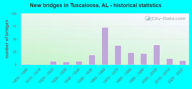
- New bridges - historical statistics
- 11900-1909
- 71920-1929
- 61930-1939
- 71940-1949
- 191950-1959
- 731960-1969
- 381970-1979
- 241980-1989
- 221990-1999
- 392000-2009
- 122010-2019
- 82020-2022
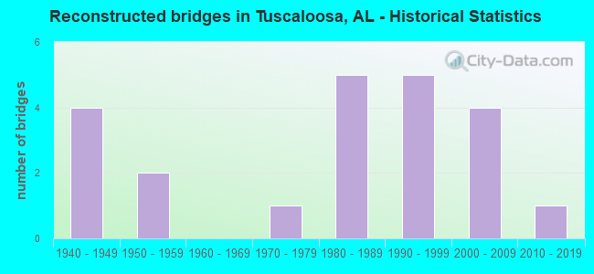
- Reconstructed bridges - Historical Statistics
- 41940-1949
- 21950-1959
- 01960-1969
- 11970-1979
- 51980-1989
- 51990-1999
- 42000-2009
- 12010-2019
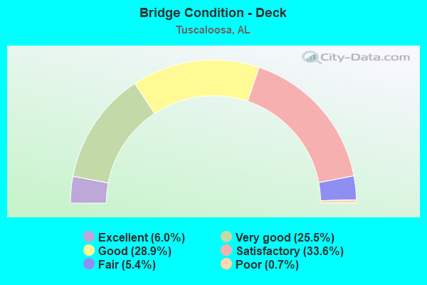
- Bridge Condition - Deck
- 6.0%Excellent
- 25.5%Very good
- 28.9%Good
- 33.6%Satisfactory
- 5.4%Fair
- 0.7%Poor
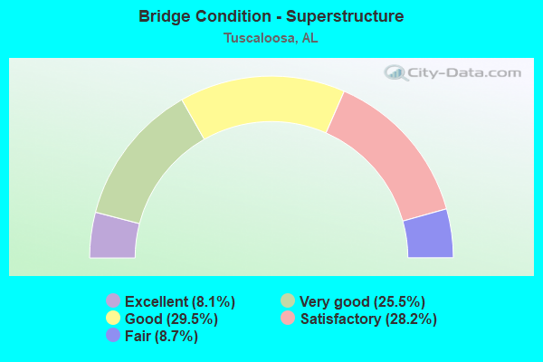
- Bridge Condition - Superstructure
- 8.1%Excellent
- 25.5%Very good
- 29.5%Good
- 28.2%Satisfactory
- 8.7%Fair
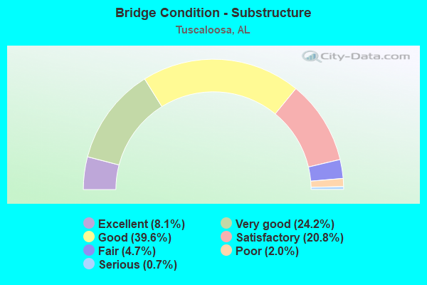
- Bridge Condition - Substructure
- 8.1%Excellent
- 24.2%Very good
- 39.6%Good
- 20.8%Satisfactory
- 4.7%Fair
- 2.0%Poor
- 0.7%Serious
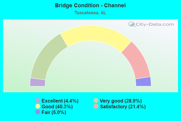
- Bridge Condition - Channel
- 4.4%Excellent
- 28.9%Very good
- 40.3%Good
- 21.4%Satisfactory
- 5.0%Fair
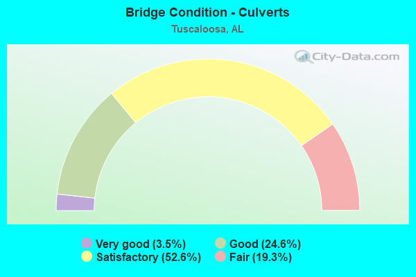
- Bridge Condition - Culverts
- 3.5%Very good
- 24.6%Good
- 52.6%Satisfactory
- 19.3%Fair
Find on map >> Show street view
Structure Number: 9892, Location: 3.0 MI N WARRIOR RIVER (Lat: 33.145467, Lng: -87.619833), Route carried "on" structure: Interstate 59, Year Built: 1969, Status: Open, Structure Length: 13.53m (44.39ft), Average Daily Traffic: 13,235 (year 2013), Truck Traffic: 35%, Average Future Daily Traffic: 16,374 (year 2033), Design Load: HS 20, Features Intersected: WARRIOR RIVER RELIEF
Minimum Vertical Clearance: 30+ m (98+ ft), Kilometerpoint: 108.011, Lanes on structure: 2, Base Highway Network: Yes, Owner: State Highway Agency, Approaching Roadway Width: 11.9m (39.0ft), Skew: 13 degrees, Material/Design: Concrete, Design/Construction: Tee Beam, Number Of Spans In Main Unit: 13, Length of Maximum Span: 10.4m (34.1ft), Curb or Sidewalk Widths: Left: 0.2m (0.7ft), Right: 0.2m (0.7ft), Curb-To-Curb Width: 12.0m (39.4ft), Out-to-Out Width: 13.1m (43.0ft)
Condition: Deck: Satisfactory, Superstructure: Satisfactory, Substructure: Satisfactory, Channel: Very good, Operating Rating: 45.0 metric tons, Method Used To Determine Operating Rating: Load Factor (LF), Inventory Rating: 26.9 metric tons, Method Used To Determine Inventory Rating: Load Factor (LF), Structural Evaluation: Equal to present minimum criteria, Deck Geometry: Equal to present minimum criteria, Waterway Adequacy: Equal to present minimum criteria, Approach Roadway Alignment: Equal to present desirable criteria, Length Of Structure Improvement: 14.34m (47.05ft), Designated Inspection Frequency: Every 24 months, Inspection Date: July 2021, Bridge Improvement Cost: $4,229,000, Roadway Improvement Cost: $423,000, Total Project Cost: $4,652,000 ( Estimate for 2022), Deck Structure Type: Concrete Cast-file-Place
Find on map >> Show street view
Structure Number: 9893, Location: 3.0 MI N OF WARRIOR RIVER (Lat: 33.145133, Lng: -87.619450), Route carried "on" structure: Interstate 59, Year Built: 1969, Status: Open, Structure Length: 13.53m (44.39ft), Average Daily Traffic: 13,235 (year 2013), Truck Traffic: 35%, Average Future Daily Traffic: 16,374 (year 2033), Design Load: HS 20, Features Intersected: WARRIOR RIVER RELIEF
Minimum Vertical Clearance: 30+ m (98+ ft), Kilometerpoint: 108.011, Lanes on structure: 2, Base Highway Network: Yes, Owner: State Highway Agency, Approaching Roadway Width: 11.9m (39.0ft), Skew: 13 degrees, Material/Design: Concrete, Design/Construction: Tee Beam, Number Of Spans In Main Unit: 13, Length of Maximum Span: 10.4m (34.1ft), Curb or Sidewalk Widths: Left: 0.2m (0.7ft), Right: 0.2m (0.7ft), Curb-To-Curb Width: 12.0m (39.4ft), Out-to-Out Width: 13.1m (43.0ft)
Condition: Deck: Satisfactory, Superstructure: Fair, Substructure: Satisfactory, Channel: Satisfactory, Operating Rating: 45.0 metric tons, Method Used To Determine Operating Rating: Load Factor (LF), Inventory Rating: 26.9 metric tons, Method Used To Determine Inventory Rating: Load Factor (LF), Structural Evaluation: Somewhat better than minimum adequacy, Deck Geometry: Equal to present minimum criteria, Waterway Adequacy: Equal to present minimum criteria, Approach Roadway Alignment: Equal to present desirable criteria, Length Of Structure Improvement: 14.34m (47.05ft), Designated Inspection Frequency: Every 24 months, Inspection Date: July 2021, Bridge Improvement Cost: $4,229,000, Roadway Improvement Cost: $423,000, Total Project Cost: $4,652,000 ( Estimate for 2022), Deck Structure Type: Concrete Cast-file-Place
Find on map >> Show street view
Structure Number: 9894, Location: 3.6 MI N WARRIOR RIVER (Lat: 33.149583, Lng: -87.610600), Route carried "on" structure: Interstate 59, Year Built: 1969, Status: Open, Structure Length: 3.11m (10.20ft), Average Daily Traffic: 13,235 (year 2013), Truck Traffic: 35%, Average Future Daily Traffic: 16,374 (year 2033), Design Load: HS 20, Features Intersected: WARRIOR RIVER RELIEF
Minimum Vertical Clearance: 30+ m (98+ ft), Kilometerpoint: 109.009, Lanes on structure: 2, Base Highway Network: Yes, Owner: State Highway Agency, Approaching Roadway Width: 12.2m (40.0ft), Skew: 10 degrees, Material/Design: Concrete, Design/Construction: Tee Beam, Number Of Spans In Main Unit: 3, Length of Maximum Span: 10.4m (34.1ft), Curb or Sidewalk Widths: Left: 0.2m (0.7ft), Right: 0.2m (0.7ft), Curb-To-Curb Width: 12.0m (39.4ft), Out-to-Out Width: 13.2m (43.3ft)
Condition: Deck: Good, Superstructure: Satisfactory, Substructure: Satisfactory, Channel: Satisfactory, Operating Rating: 45.0 metric tons, Method Used To Determine Operating Rating: Load Factor (LF), Inventory Rating: 26.9 metric tons, Method Used To Determine Inventory Rating: Load Factor (LF), Structural Evaluation: Equal to present minimum criteria, Deck Geometry: Equal to present minimum criteria, Waterway Adequacy: Equal to present minimum criteria, Approach Roadway Alignment: Better than present minimum criteria, Length Of Structure Improvement: 3.96m (12.99ft), Designated Inspection Frequency: Every 24 months, Inspection Date: July 2021, Bridge Improvement Cost: $1,168,000, Roadway Improvement Cost: $117,000, Total Project Cost: $1,285,000 ( Estimate for 2022), Deck Structure Type: Concrete Cast-file-Place
Find on map >> Show street view
Structure Number: 9895, Location: 3.6 MI N WARRIOR RIVER (Lat: 33.149033, Lng: -87.609200), Route carried "on" structure: Interstate 59, Year Built: 1969, Status: Open, Structure Length: 3.11m (10.20ft), Average Daily Traffic: 13,235 (year 2013), Truck Traffic: 35%, Average Future Daily Traffic: 16,374 (year 2033), Design Load: HS 20, Features Intersected: WARRIOR RIVER RELIEF
Minimum Vertical Clearance: 30+ m (98+ ft), Kilometerpoint: 109.009, Lanes on structure: 2, Base Highway Network: Yes, Owner: State Highway Agency, Approaching Roadway Width: 12.2m (40.0ft), Skew: 14 degrees, Material/Design: Concrete, Design/Construction: Tee Beam, Number Of Spans In Main Unit: 3, Length of Maximum Span: 10.4m (34.1ft), Curb or Sidewalk Widths: Left: 0.2m (0.7ft), Right: 0.2m (0.7ft), Curb-To-Curb Width: 12.0m (39.4ft), Out-to-Out Width: 13.2m (43.3ft)
Condition: Deck: Satisfactory, Superstructure: Satisfactory, Substructure: Satisfactory, Channel: Very good, Operating Rating: 45.0 metric tons, Method Used To Determine Operating Rating: Load Factor (LF), Inventory Rating: 26.9 metric tons, Method Used To Determine Inventory Rating: Load Factor (LF), Structural Evaluation: Equal to present minimum criteria, Deck Geometry: Equal to present minimum criteria, Waterway Adequacy: Equal to present minimum criteria, Approach Roadway Alignment: Equal to present desirable criteria, Length Of Structure Improvement: 3.96m (12.99ft), Designated Inspection Frequency: Every 24 months, Inspection Date: July 2021, Bridge Improvement Cost: $1,168,000, Roadway Improvement Cost: $117,000, Total Project Cost: $1,285,000 ( Estimate for 2022), Deck Structure Type: Concrete Cast-file-Place
Find on map >> Show street view
Structure Number: 9896, Location: 3.3 MI S JCT I-359 (Lat: 33.151767, Lng: -87.602800), Route carried "on" structure: Interstate 59, Year Built: 1969, Year Reconstructed: 1998, Status: Open, Structure Length: 7.25m (23.79ft), Average Daily Traffic: 13,235 (year 2013), Truck Traffic: 35%, Average Future Daily Traffic: 16,374 (year 2033), Design Load: HS 20, Features Intersected: WARRIOR RIVER RELIEF, Facility Carried by Structure: I-20
Minimum Vertical Clearance: 30+ m (98+ ft), Kilometerpoint: 109.699, Lanes on structure: 3, Base Highway Network: Yes, Owner: State Highway Agency, Approaching Roadway Width: 15.5m (50.9ft), Skew: 14 degrees, Material/Design: Concrete, Design/Construction: Tee Beam, Number Of Spans In Main Unit: 7, Length of Maximum Span: 10.4m (34.1ft), Curb or Sidewalk Widths: Left: 0.2m (0.7ft), Right: 0.2m (0.7ft), Curb-To-Curb Width: 15.5m (50.9ft), Out-to-Out Width: 16.5m (54.1ft)
Condition: Deck: Satisfactory, Superstructure: Satisfactory, Substructure: Satisfactory, Channel: Good, Operating Rating: 48.3 metric tons, Method Used To Determine Operating Rating: Load Factor (LF), Inventory Rating: 29.0 metric tons, Method Used To Determine Inventory Rating: Load Factor (LF), Structural Evaluation: Equal to present minimum criteria, Deck Geometry: Somewhat better than minimum adequacy, Waterway Adequacy: Equal to present minimum criteria, Approach Roadway Alignment: Equal to present desirable criteria, Length Of Structure Improvement: 8.28m (27.17ft), Designated Inspection Frequency: Every 24 months, Inspection Date: July 2021, Bridge Improvement Cost: $3,067,000, Roadway Improvement Cost: $307,000, Total Project Cost: $3,374,000 ( Estimate for 2022), Deck Structure Type: Concrete Cast-file-Place
Find on map >> Show street view
Structure Number: 9897, Location: 3.3 MI S JCT I-359 (Lat: 33.151133, Lng: -87.603167), Route carried "on" structure: Interstate 59, Year Built: 1969, Status: Open, Structure Length: 7.28m (23.88ft), Average Daily Traffic: 13,235 (year 2013), Truck Traffic: 35%, Average Future Daily Traffic: 16,374 (year 2033), Design Load: HS 20, Features Intersected: WARRIOR RIVER RELIEF, Facility Carried by Structure: I-20
Minimum Vertical Clearance: 30+ m (98+ ft), Kilometerpoint: 109.699, Lanes on structure: 2, Base Highway Network: Yes, Owner: State Highway Agency, Approaching Roadway Width: 11.9m (39.0ft), Skew: 14 degrees, Material/Design: Concrete, Design/Construction: Tee Beam, Number Of Spans In Main Unit: 7, Length of Maximum Span: 10.4m (34.1ft), Curb or Sidewalk Widths: Left: 0.2m (0.7ft), Right: 0.2m (0.7ft), Curb-To-Curb Width: 12.0m (39.4ft), Out-to-Out Width: 13.1m (43.0ft)
Condition: Deck: Good, Superstructure: Satisfactory, Substructure: Good, Channel: Good, Operating Rating: 43.1 metric tons, Method Used To Determine Operating Rating: Load Factor (LF), Inventory Rating: 25.9 metric tons, Method Used To Determine Inventory Rating: Load Factor (LF), Structural Evaluation: Equal to present minimum criteria, Deck Geometry: Equal to present minimum criteria, Waterway Adequacy: Equal to present minimum criteria, Approach Roadway Alignment: Better than present minimum criteria, Length Of Structure Improvement: 8.31m (27.26ft), Designated Inspection Frequency: Every 24 months, Inspection Date: July 2021, Bridge Improvement Cost: $2,451,000, Roadway Improvement Cost: $245,000, Total Project Cost: $2,696,000 ( Estimate for 2022), Deck Structure Type: Concrete Cast-file-Place
Find on map >> Show street view
Structure Number: 9898, Location: 2.6 MI S JCT I-359 (Lat: 33.154953, Lng: -87.591189), Route carried "on" structure: Interstate 59, Year Built: 1969, Status: Open, Structure Length: 4.18m (13.71ft), Average Daily Traffic: 15,645 (year 2013), Truck Traffic: 35%, Average Future Daily Traffic: 19,356 (year 2033), Design Load: HS 20, Features Intersected: WARRIOR RIVER RELIEF
Minimum Vertical Clearance: 30+ m (98+ ft), Kilometerpoint: 110.868, Lanes on structure: 2, Base Highway Network: Yes, Owner: State Highway Agency, Approaching Roadway Width: 11.9m (39.0ft), Skew: 10 degrees, Material/Design: Concrete, Design/Construction: Tee Beam, Number Of Spans In Main Unit: 4, Length of Maximum Span: 10.4m (34.1ft), Curb or Sidewalk Widths: Left: 0.2m (0.7ft), Right: 0.2m (0.7ft), Curb-To-Curb Width: 12.0m (39.4ft), Out-to-Out Width: 13.1m (43.0ft)
Condition: Deck: Good, Superstructure: Good, Substructure: Good, Channel: Good, Operating Rating: 45.0 metric tons, Method Used To Determine Operating Rating: Load Factor (LF), Inventory Rating: 26.9 metric tons, Method Used To Determine Inventory Rating: Load Factor (LF), Structural Evaluation: Equal to present minimum criteria, Deck Geometry: Equal to present minimum criteria, Waterway Adequacy: Equal to present minimum criteria, Approach Roadway Alignment: Equal to present desirable criteria, Length Of Structure Improvement: 5.14m (16.86ft), Designated Inspection Frequency: Every 24 months, Inspection Date: July 2021, Bridge Improvement Cost: $1,517,000, Roadway Improvement Cost: $152,000, Total Project Cost: $1,669,000 ( Estimate for 2022), Deck Structure Type: Concrete Cast-file-Place
Find on map >> Show street view
Structure Number: 9899, Location: 2.6 MI S JCT I-359 (Lat: 33.154742, Lng: -87.591069), Route carried "on" structure: Interstate 59, Year Built: 1969, Year Reconstructed: 1998, Status: Open, Structure Length: 4.15m (13.62ft), Average Daily Traffic: 15,645 (year 2013), Truck Traffic: 35%, Average Future Daily Traffic: 19,356 (year 2033), Design Load: HS 20, Features Intersected: WARRIOR RIVER RELIEF, Facility Carried by Structure: I-20
Minimum Vertical Clearance: 30+ m (98+ ft), Kilometerpoint: 110.868, Lanes on structure: 3, Base Highway Network: Yes, Owner: State Highway Agency, Approaching Roadway Width: 15.7m (51.5ft), Skew: 10 degrees, Material/Design: Concrete, Design/Construction: Tee Beam, Number Of Spans In Main Unit: 4, Length of Maximum Span: 10.4m (34.1ft), Curb or Sidewalk Widths: Left: 0.2m (0.7ft), Right: 0.2m (0.7ft), Curb-To-Curb Width: 15.7m (51.5ft), Out-to-Out Width: 16.7m (54.8ft)
Condition: Deck: Good, Superstructure: Satisfactory, Substructure: Good, Channel: Good, Operating Rating: 49.4 metric tons, Method Used To Determine Operating Rating: Load Factor (LF), Inventory Rating: 29.6 metric tons, Method Used To Determine Inventory Rating: Load Factor (LF), Structural Evaluation: Equal to present minimum criteria, Deck Geometry: Somewhat better than minimum adequacy, Waterway Adequacy: Equal to present minimum criteria, Approach Roadway Alignment: Equal to present desirable criteria, Length Of Structure Improvement: 5.11m (16.77ft), Designated Inspection Frequency: Every 24 months, Inspection Date: July 2021, Bridge Improvement Cost: $1,892,000, Roadway Improvement Cost: $189,000, Total Project Cost: $2,081,000 ( Estimate for 2022), Deck Structure Type: Concrete Cast-file-Place
Find on map >> Show street view
Structure Number: 99, Location: 1.9 MI S JCT I-359 (Lat: 33.158833, Lng: -87.578900), Route carried "on" structure: Interstate 59, Year Built: 1969, Status: Open, Structure Length: 5.21m (17.09ft), Average Daily Traffic: 15,960 (year 2015), Truck Traffic: 35%, Average Future Daily Traffic: 23,940 (year 2039), Design Load: HS 20, Features Intersected: WARRIOR RIVER RELIEF 13
Minimum Vertical Clearance: 30+ m (98+ ft), Kilometerpoint: 112.097, Lanes on structure: 2, Base Highway Network: Yes, Owner: State Highway Agency, Approaching Roadway Width: 11.9m (39.0ft), Skew: 10 degrees, Material/Design: Concrete, Design/Construction: Tee Beam, Number Of Spans In Main Unit: 5, Length of Maximum Span: 10.4m (34.1ft), Curb or Sidewalk Widths: Left: 0.2m (0.7ft), Right: 0.2m (0.7ft), Curb-To-Curb Width: 12.0m (39.4ft), Out-to-Out Width: 13.1m (43.0ft)
Condition: Deck: Satisfactory, Superstructure: Satisfactory, Substructure: Satisfactory, Channel: Fair, Operating Rating: 45.0 metric tons, Method Used To Determine Operating Rating: Load Factor (LF), Inventory Rating: 26.9 metric tons, Method Used To Determine Inventory Rating: Load Factor (LF), Structural Evaluation: Equal to present minimum criteria, Deck Geometry: Equal to present minimum criteria, Waterway Adequacy: Equal to present minimum criteria, Approach Roadway Alignment: Equal to present desirable criteria, Length Of Structure Improvement: 6.24m (20.47ft), Designated Inspection Frequency: Every 24 months, Inspection Date: June 2021, Bridge Improvement Cost: $1,796,000, Roadway Improvement Cost: $180,000, Total Project Cost: $1,976,000 ( Estimate for 2022), Deck Structure Type: Concrete Cast-file-Place
Find on map >> Show street view
Structure Number: 9903, Location: JCT I59 (Lat: 33.175681, Lng: -87.502461), Route carried "on" structure: County highway 37, Year Built: 1969, Status: Open, Structure Length: 11.70m (38.39ft), Average Daily Traffic: 10,000 (year 2009), Truck Traffic: 2%, Average Future Daily Traffic: 10,091 (year 2029), Design Load: HS 20, Features Intersected: I-59, I-20
Minimum Vertical Clearance: 30+ m (98+ ft), Kilometerpoint: 0.000, Lanes on structure: 2, Lanes under structure: 4, Owner: State Highway Agency, Approaching Roadway Width: 10.4m (34.1ft), Skew: 4 degrees, Material/Design: Concrete continuous, Design/Construction: Tee Beam, Number Of Spans In Main Unit: 4, Length of Maximum Span: 32.0m (105.0ft), Curb or Sidewalk Widths: Left: 0.4m (1.3ft), Right: 0.4m (1.3ft), Curb-To-Curb Width: 8.6m (28.2ft), Out-to-Out Width: 10.1m (33.1ft)
Condition: Deck: Satisfactory, Superstructure: Good, Substructure: Good, Operating Rating: 78.7 metric tons, Method Used To Determine Operating Rating: Load Factor (LF), Inventory Rating: 47.1 metric tons, Method Used To Determine Inventory Rating: Load Factor (LF), Structural Evaluation: Better than present minimum criteria, Deck Geometry: Meets minimum limits, Underclear: Equal to present minimum criteria, Approach Roadway Alignment: Somewhat better than minimum adequacy, Length Of Structure Improvement: 12.57m (41.24ft), Designated Inspection Frequency: Every 24 months, Inspection Date: August 2021, Bridge Improvement Cost: $2,844,000, Roadway Improvement Cost: $284,000, Total Project Cost: $3,128,000 ( Estimate for 2022), Deck Structure Type: Concrete Cast-file-Place
Find on map >> Show street view
Structure Number: 9904, Location: JCT I-59 (Lat: 33.175633, Lng: -87.489933), Route carried "on" structure: County highway , Year Built: 1969, Status: Open, Structure Length: 7.53m (24.70ft), Average Daily Traffic: 3,600 (year 2015), Truck Traffic: 1%, Average Future Daily Traffic: 5,710 (year 2035), Design Load: H 20, Features Intersected: I-59, I-20, Facility Carried by Structure: WOODLAND ROAD
Minimum Vertical Clearance: 30+ m (98+ ft), Kilometerpoint: 0.000, Lanes on structure: 2, Lanes under structure: 4, Owner: State Highway Agency, Approaching Roadway Width: 10.1m (33.1ft), Material/Design: Concrete continuous, Design/Construction: Tee Beam, Number Of Spans In Main Unit: 4, Length of Maximum Span: 20.7m (67.9ft), Curb or Sidewalk Widths: Left: 0.5m (1.6ft), Right: 0.5m (1.6ft), Curb-To-Curb Width: 8.6m (28.2ft), Out-to-Out Width: 10.2m (33.5ft)
Condition: Deck: Satisfactory, Superstructure: Fair, Substructure: Good, Operating Rating: 47.5 metric tons, Method Used To Determine Operating Rating: Load Factor (LF), Inventory Rating: 28.5 metric tons, Method Used To Determine Inventory Rating: Load Factor (LF), Structural Evaluation: Somewhat better than minimum adequacy, Deck Geometry: Meets minimum limits, Underclear: Equal to present minimum criteria, Approach Roadway Alignment: Somewhat better than minimum adequacy, Length Of Structure Improvement: 8.55m (28.05ft), Designated Inspection Frequency: Every 24 months, Inspection Date: August 2021, Bridge Improvement Cost: $1,935,000, Roadway Improvement Cost: $194,000, Total Project Cost: $2,129,000 ( Estimate for 2022), Deck Structure Type: Concrete Cast-file-Place
Find on map >> Show street view
Structure Number: 9977, Location: 0.2 MI E HARGROVE ROAD (Lat: 33.184528, Lng: -87.526278), Route carried "on" structure: US 82, Year Built: 1969, Status: Open, Structure Length: 1.34m (4.40ft), Average Daily Traffic: 46,790 (year 2016), Truck Traffic: 5%, Average Future Daily Traffic: 60,582 (year 2040), Design Load: H 15, Features Intersected: Cribbs Mill Creek
Minimum Vertical Clearance: 30+ m (98+ ft), Kilometerpoint: 84.095, Lanes on structure: 8, Base Highway Network: Yes, Owner: State Highway Agency, Approaching Roadway Width: 24.4m (80.1ft), Skew: 21 degrees, Material/Design: Concrete, Design/Construction: Culvert, Number Of Spans In Main Unit: 4, Length of Maximum Span: 3.2m (10.5ft)
Condition: Channel: Good, Culverts: Satisfactory, Operating Rating: 88.9 metric tons, Method Used To Determine Operating Rating: Load Factor (LF), Inventory Rating: 88.9 metric tons, Method Used To Determine Inventory Rating: Load Factor (LF), Structural Evaluation: Equal to present minimum criteria, Waterway Adequacy: Equal to present minimum criteria, Approach Roadway Alignment: Equal to present desirable criteria, Length Of Structure Improvement: 2.02m (6.63ft), Designated Inspection Frequency: Every 24 months, Inspection Date: March 2020, Bridge Improvement Cost: $1,933,000, Roadway Improvement Cost: $193,000, Total Project Cost: $2,126,000 ( Estimate for 2022)
Find on map >> Show street view
Structure Number: 9978, Location: 0.6 MI E HARGROVE ROAD (Lat: 33.178575, Lng: -87.525061), Route carried "on" structure: US 82, Year Built: 1969, Status: Open, Structure Length: 1.31m (4.30ft), Average Daily Traffic: 46,790 (year 2013), Truck Traffic: 5%, Average Future Daily Traffic: 60,582 (year 2040), Design Load: H 20, Features Intersected: Bowers Park Creek
Minimum Vertical Clearance: 30+ m (98+ ft), Kilometerpoint: 84.767, Lanes on structure: 7, Base Highway Network: Yes, Owner: State Highway Agency, Approaching Roadway Width: 32.6m (107.0ft), Skew: 20 degrees, Material/Design: Concrete, Design/Construction: Culvert, Number Of Spans In Main Unit: 4, Length of Maximum Span: 3.0m (9.8ft)
Condition: Channel: Satisfactory, Culverts: Satisfactory, Operating Rating: 58.6 metric tons, Method Used To Determine Operating Rating: Load Factor (LF), Inventory Rating: 35.1 metric tons, Method Used To Determine Inventory Rating: Load Factor (LF), Structural Evaluation: Equal to present minimum criteria, Waterway Adequacy: Better than present minimum criteria, Approach Roadway Alignment: Equal to present desirable criteria, Length Of Structure Improvement: 1.98m (6.50ft), Designated Inspection Frequency: Every 24 months, Inspection Date: March 2020, Bridge Improvement Cost: $1,650,000, Roadway Improvement Cost: $165,000, Total Project Cost: $1,815,000 ( Estimate for 2022)
Find on map >> Show street view
Structure Number: 9979, Location: 0.7MI E HARGROVE RD (Lat: 33.177000, Lng: -87.524900), Route carried "on" structure: US 82, Year Built: 1969, Status: Open, Structure Length: 1.49m (4.89ft), Average Daily Traffic: 46,790 (year 2016), Truck Traffic: 5%, Average Future Daily Traffic: 60,582 (year 2040), Design Load: H 20, Features Intersected: Trib. Cribbs Mill Creek
Minimum Vertical Clearance: 30+ m (98+ ft), Kilometerpoint: 84.952, Lanes on structure: 8, Base Highway Network: Yes, Owner: State Highway Agency, Approaching Roadway Width: 32.6m (107.0ft), Skew: 23 degrees, Material/Design: Concrete, Design/Construction: Culvert, Number Of Spans In Main Unit: 4, Length of Maximum Span: 3.5m (11.5ft)
Condition: Channel: Good, Culverts: Satisfactory, Operating Rating: 74.7 metric tons, Method Used To Determine Operating Rating: Load Factor (LF), Inventory Rating: 44.7 metric tons, Method Used To Determine Inventory Rating: Load Factor (LF), Structural Evaluation: Equal to present minimum criteria, Waterway Adequacy: Equal to present minimum criteria, Approach Roadway Alignment: Equal to present desirable criteria, Length Of Structure Improvement: 2.17m (7.12ft), Designated Inspection Frequency: Every 24 months, Inspection Date: March 2020, Bridge Improvement Cost: $2,221,000, Roadway Improvement Cost: $222,000, Total Project Cost: $2,443,000 ( Estimate for 2022)
Find on map >> Show street view
Structure Number: 10103, Location: 0.4 MI E OF JCT US NO 43 (Lat: 33.355447, Lng: -87.604883), Route carried "on" structure: County highway 200, Year Built: 1969, Status: Posted for load, Structure Length: 14.48m (47.51ft), Average Daily Traffic: 2,000 (year 2018), Truck Traffic: 5%, Average Future Daily Traffic: 2,400 (year 2035), Design Load: HS 20, Features Intersected: NORTH RIVER, Facility Carried by Structure: TIERCE PATTON RD.
Minimum Vertical Clearance: 30+ m (98+ ft), Kilometerpoint: 0.010, Lanes on structure: 2, Owner: County Highway Agency, Approaching Roadway Width: 9.1m (29.9ft), Material/Design: Steel continuous, Design/Construction: Stringer/Multi-beam, Number Of Spans In Main Unit: 4, Number Of Approach Spans: 1, Length of Maximum Span: 30.5m (100.1ft), Curb or Sidewalk Widths: Left: 0.5m (1.6ft), Right: 0.5m (1.6ft), Curb-To-Curb Width: 7.0m (23.0ft), Out-to-Out Width: 8.8m (28.9ft)
Condition: Deck: Satisfactory, Superstructure: Satisfactory, Substructure: Good, Channel: Very good, Operating Rating: 38.6 metric tons, Method Used To Determine Operating Rating: Load Factor (LF), Inventory Rating: 23.1 metric tons, Method Used To Determine Inventory Rating: Load Factor (LF), Structural Evaluation: Equal to present minimum criteria, Deck Geometry: High priority of corrective action, Waterway Adequacy: Equal to present desirable criteria, Approach Roadway Alignment: Superior to present desirable criteria, Bridge Posting: Required (Relationship of Operating Rating to Maximum Legal Load: 10.0 - 19.9% below), Length Of Structure Improvement: 15.26m (50.07ft), Designated Inspection Frequency: Every 24 months, Underwater Inspection Frequency: Every 48 months, Other Special Inspection Frequency: Every 12 months, Inspection Date: April 2020, Underwater Inspection Date: June 2021, Other Special Inspection Date: April 2021, Bridge Improvement Cost: $3,035,000, Roadway Improvement Cost: $304,000, Total Project Cost: $3,339,000 ( Estimate for 2022), Deck Structure Type: Concrete Cast-file-Place
Find on map >> Show street view
Structure Number: 1016, Location: 0.4 MI N HAMMS POTTERY (Lat: 33.175622, Lng: -87.398983), Route carried "on" structure: Interstate 59, Year Built: 1964, Year Reconstructed: 1970, Status: Open, Structure Length: 1.10m (3.61ft), Average Daily Traffic: 47,400 (year 2017), Truck Traffic: 32%, Average Future Daily Traffic: 71,100 (year 2041), Design Load: H 20, Features Intersected: Bee Branch
Minimum Vertical Clearance: 30+ m (98+ ft), Kilometerpoint: 129.343, Lanes on structure: 6, Base Highway Network: Yes, Owner: State Highway Agency, Approaching Roadway Width: 24.7m (81.0ft), Skew: 3 degrees, Material/Design: Concrete, Design/Construction: Culvert, Number Of Spans In Main Unit: 3, Length of Maximum Span: 3.5m (11.5ft)
Condition: Channel: Satisfactory, Culverts: Fair, Operating Rating: 88.9 metric tons, Method Used To Determine Operating Rating: Load Factor (LF), Inventory Rating: 88.9 metric tons, Method Used To Determine Inventory Rating: Load Factor (LF), Structural Evaluation: Somewhat better than minimum adequacy, Waterway Adequacy: Equal to present minimum criteria, Approach Roadway Alignment: Equal to present desirable criteria, Length Of Structure Improvement: 1.77m (5.81ft), Designated Inspection Frequency: Every 24 months, Inspection Date: June 2021, Bridge Improvement Cost: $4,557,000, Roadway Improvement Cost: $456,000, Total Project Cost: $5,013,000 ( Estimate for 2022)
Find on map >> Show street view
Structure Number: 10161, Location: 0.3 MI N JCT SKYLAND BLVD (Lat: 33.169667, Lng: -87.552833), Route carried "on" structure: Spur Interstate 359, Year Built: 1970, Status: Open, Structure Length: 9.45m (31.00ft), Average Daily Traffic: 20,365 (year 2013), Truck Traffic: 10%, Average Future Daily Traffic: 24,849 (year 2033), Design Load: HS 20, Features Intersected: I 59,I 20
Minimum Vertical Clearance: 30+ m (98+ ft), Kilometerpoint: 0.554, Lanes on structure: 3, Lanes under structure: 6, Base Highway Network: Yes, Owner: State Highway Agency, Approaching Roadway Width: 15.8m (51.8ft), Skew: 10 degrees, Material/Design: Concrete continuous, Design/Construction: Tee Beam, Number Of Spans In Main Unit: 4, Length of Maximum Span: 25.9m (85.0ft), Curb or Sidewalk Widths: Left: 0.2m (0.7ft), Right: 0.2m (0.7ft), Curb-To-Curb Width: 15.7m (51.5ft), Out-to-Out Width: 16.8m (55.1ft)
Condition: Deck: Good, Superstructure: Good, Substructure: Good, Operating Rating: 70.0 metric tons, Method Used To Determine Operating Rating: Load Factor (LF), Inventory Rating: 41.9 metric tons, Method Used To Determine Inventory Rating: Load Factor (LF), Structural Evaluation: Better than present minimum criteria, Deck Geometry: Somewhat better than minimum adequacy, Underclear: Equal to present minimum criteria, Approach Roadway Alignment: Equal to present desirable criteria, Length Of Structure Improvement: 10.40m (34.12ft), Designated Inspection Frequency: Every 24 months, Inspection Date: October 2021, Bridge Improvement Cost: $3,923,000, Roadway Improvement Cost: $392,000, Total Project Cost: $4,315,000 ( Estimate for 2022), Deck Structure Type: Concrete Cast-file-Place
Find on map >> Show street view
Structure Number: 10162, Location: 0.3 MI N JCT SKYLAND BLVD (Lat: 33.169833, Lng: -87.552500), Route carried "on" structure: Spur Interstate 359, Year Built: 1970, Status: Open, Structure Length: 9.45m (31.00ft), Average Daily Traffic: 20,365 (year 2013), Truck Traffic: 10%, Average Future Daily Traffic: 24,849 (year 2033), Design Load: HS 20, Features Intersected: I 59,I-20
Minimum Vertical Clearance: 30+ m (98+ ft), Kilometerpoint: 0.554, Lanes on structure: 3, Lanes under structure: 6, Base Highway Network: Yes, Owner: State Highway Agency, Approaching Roadway Width: 15.8m (51.8ft), Skew: 10 degrees, Material/Design: Concrete continuous, Design/Construction: Tee Beam, Number Of Spans In Main Unit: 4, Length of Maximum Span: 25.9m (85.0ft), Curb or Sidewalk Widths: Left: 0.2m (0.7ft), Right: 0.2m (0.7ft), Curb-To-Curb Width: 15.7m (51.5ft), Out-to-Out Width: 16.8m (55.1ft)
Condition: Deck: Good, Superstructure: Good, Substructure: Good, Operating Rating: 70.0 metric tons, Method Used To Determine Operating Rating: Load Factor (LF), Inventory Rating: 41.9 metric tons, Method Used To Determine Inventory Rating: Load Factor (LF), Structural Evaluation: Better than present minimum criteria, Deck Geometry: Somewhat better than minimum adequacy, Underclear: Better than present minimum criteria, Approach Roadway Alignment: Equal to present desirable criteria, Length Of Structure Improvement: 10.40m (34.12ft), Designated Inspection Frequency: Every 24 months, Inspection Date: October 2021, Bridge Improvement Cost: $3,923,000, Roadway Improvement Cost: $392,000, Total Project Cost: $4,315,000 ( Estimate for 2022), Deck Structure Type: Concrete Cast-file-Place
Find on map >> Show street view
Structure Number: 10181, Location: 2.5 MI S JCT I-359 (Lat: 33.155333, Lng: -87.588050), Route carried "on" structure: County highway , Year Built: 1970, Status: Open, Structure Length: 8.50m (27.89ft), Average Daily Traffic: 500 (year 2010), Truck Traffic: 90%, Average Future Daily Traffic: 653 (year 2030), Design Load: HS 20, Features Intersected: I-59, I-20, Facility Carried by Structure: CR (ST BUNN)
Minimum Vertical Clearance: 30+ m (98+ ft), Kilometerpoint: 0.000, Lanes on structure: 2, Lanes under structure: 4, Owner: State Highway Agency, Approaching Roadway Width: 9.1m (29.9ft), Material/Design: Steel continuous, Design/Construction: Stringer/Multi-beam, Number Of Spans In Main Unit: 4, Length of Maximum Span: 25.3m (83.0ft), Curb or Sidewalk Widths: Left: 0.2m (0.7ft), Right: 0.2m (0.7ft), Curb-To-Curb Width: 8.6m (28.2ft), Out-to-Out Width: 9.7m (31.8ft)
Condition: Deck: Fair, Superstructure: Satisfactory, Substructure: Good, Operating Rating: 62.3 metric tons, Method Used To Determine Operating Rating: Load Factor (LF), Inventory Rating: 37.3 metric tons, Method Used To Determine Inventory Rating: Load Factor (LF), Structural Evaluation: Equal to present minimum criteria, Deck Geometry: Somewhat better than minimum adequacy, Underclear: Somewhat better than minimum adequacy, Approach Roadway Alignment: Equal to present minimum criteria, Length Of Structure Improvement: 9.49m (31.14ft), Designated Inspection Frequency: Every 24 months, Inspection Date: January 2022, Bridge Improvement Cost: $2,017,000, Roadway Improvement Cost: $202,000, Total Project Cost: $2,219,000 ( Estimate for 2022), Deck Structure Type: Concrete Cast-file-Place
Find on map >> Show street view
Structure Number: 10182, Location: 0.3 MI S JCT I-359 (Lat: 33.167811, Lng: -87.558283), Route carried "on" structure: Interstate 59, Year Built: 1970, Status: Open, Structure Length: 9.30m (30.51ft), Average Daily Traffic: 15,645 (year 2013), Truck Traffic: 35%, Average Future Daily Traffic: 19,356 (year 2033), Design Load: HS 20, Features Intersected: AL-SOUTH RR* KAULOOSA, Facility Carried by Structure: I-20
Minimum Vertical Clearance: 30+ m (98+ ft), Kilometerpoint: 114.288, Lanes on structure: 3, Lanes under structure: 2, Base Highway Network: Yes, Owner: State Highway Agency, Approaching Roadway Width: 14.6m (47.9ft), Skew: 12 degrees, Material/Design: Concrete continuous, Design/Construction: Tee Beam, Number Of Spans In Main Unit: 4, Number Of Approach Spans: 1, Length of Maximum Span: 20.7m (67.9ft), Curb or Sidewalk Widths: Left: 0.2m (0.7ft), Right: 0.2m (0.7ft), Curb-To-Curb Width: 15.7m (51.5ft), Out-to-Out Width: 16.8m (55.1ft)
Condition: Deck: Satisfactory, Superstructure: Good, Substructure: Good, Operating Rating: 49.9 metric tons, Method Used To Determine Operating Rating: Load Factor (LF), Inventory Rating: 29.8 metric tons, Method Used To Determine Inventory Rating: Load Factor (LF), Structural Evaluation: Better than present minimum criteria, Deck Geometry: Somewhat better than minimum adequacy, Underclear: Meets minimum limits, Approach Roadway Alignment: Equal to present desirable criteria, Length Of Structure Improvement: 10.25m (33.63ft), Designated Inspection Frequency: Every 24 months, Inspection Date: October 2021, Bridge Improvement Cost: $3,867,000, Roadway Improvement Cost: $387,000, Total Project Cost: $4,254,000 ( Estimate for 2022), Deck Structure Type: Concrete Cast-file-Place
Find on map >> Show street view
Structure Number: 10183, Location: 0.3 MI S JCT I-359 (Lat: 33.167653, Lng: -87.558008), Route carried "on" structure: Interstate 59, Year Built: 1970, Status: Open, Structure Length: 9.30m (30.51ft), Average Daily Traffic: 15,645 (year 2013), Truck Traffic: 35%, Average Future Daily Traffic: 19,356 (year 2033), Design Load: HS 20, Features Intersected: GM*0 RR * KAULOOSA AVE, Facility Carried by Structure: I-20
Minimum Vertical Clearance: 30+ m (98+ ft), Kilometerpoint: 114.288, Lanes on structure: 2, Lanes under structure: 2, Base Highway Network: Yes, Owner: State Highway Agency, Approaching Roadway Width: 14.6m (47.9ft), Skew: 12 degrees, Material/Design: Concrete continuous, Design/Construction: Tee Beam, Number Of Spans In Main Unit: 4, Number Of Approach Spans: 1, Length of Maximum Span: 20.7m (67.9ft), Curb or Sidewalk Widths: Left: 0.2m (0.7ft), Right: 0.2m (0.7ft), Curb-To-Curb Width: 15.7m (51.5ft), Out-to-Out Width: 16.8m (55.1ft)
Condition: Deck: Good, Superstructure: Good, Substructure: Good, Operating Rating: 58.6 metric tons, Method Used To Determine Operating Rating: Load Factor (LF), Inventory Rating: 35.1 metric tons, Method Used To Determine Inventory Rating: Load Factor (LF), Structural Evaluation: Better than present minimum criteria, Deck Geometry: Superior to present desirable criteria, Underclear: High priority of corrective action, Approach Roadway Alignment: Equal to present desirable criteria, Length Of Structure Improvement: 10.25m (33.63ft), Designated Inspection Frequency: Every 24 months, Inspection Date: October 2021, Bridge Improvement Cost: $3,867,000, Roadway Improvement Cost: $387,000, Total Project Cost: $4,254,000 ( Estimate for 2019), Deck Structure Type: Concrete Cast-file-Place
Find on map >> Show street view
Structure Number: 10184, Location: SKYLAND SCHOOL (Lat: 33.170514, Lng: -87.532281), Route carried "on" structure: City street , Year Built: 1970, Status: Open, Structure Length: 8.23m (27.00ft), Average Daily Traffic: 6,500 (year 2009), Truck Traffic: 2%, Average Future Daily Traffic: 8,900 (year 2035), Design Load: HS 20, Features Intersected: I-59, I-20, Facility Carried by Structure: THIRD AVENUE
Minimum Vertical Clearance: 30+ m (98+ ft), Kilometerpoint: 0.000, Lanes on structure: 2, Lanes under structure: 6, Owner: State Highway Agency, Approaching Roadway Width: 9.7m (31.8ft), Material/Design: Steel continuous, Design/Construction: Stringer/Multi-beam, Number Of Spans In Main Unit: 4, Length of Maximum Span: 25.6m (84.0ft), Curb or Sidewalk Widths: Left: 1.5m (4.9ft), Right: 1.5m (4.9ft), Curb-To-Curb Width: 15.9m (52.2ft), Out-to-Out Width: 19.7m (64.6ft)
Condition: Deck: Satisfactory, Superstructure: Good, Substructure: Good, Operating Rating: 60.3 metric tons, Method Used To Determine Operating Rating: Load Factor (LF), Inventory Rating: 36.1 metric tons, Method Used To Determine Inventory Rating: Load Factor (LF), Structural Evaluation: Better than present minimum criteria, Deck Geometry: Superior to present desirable criteria, Underclear: Somewhat better than minimum adequacy, Approach Roadway Alignment: Better than present minimum criteria, Length Of Structure Improvement: 9.23m (30.28ft), Designated Inspection Frequency: Every 24 months, Inspection Date: October 2021, Bridge Improvement Cost: $4,050,000, Roadway Improvement Cost: $405,000, Total Project Cost: $4,455,000 ( Estimate for 2022), Deck Structure Type: Concrete Cast-file-Place
Find on map >> Show street view
Structure Number: 10278, Location: 0.2 MI E WARRIOR RIVER (Lat: 33.220100, Lng: -87.531500), Route carried "on" structure: City street , Year Built: 1970, Status: Open, Structure Length: 8.66m (28.41ft), Average Daily Traffic: 19,445 (year 2013), Truck Traffic: 1%, Average Future Daily Traffic: 14,580 (year 2030), Design Load: HS 20, Features Intersected: US 82, Facility Carried by Structure: JACK WARNER PKWY
Minimum Vertical Clearance: 30+ m (98+ ft), Kilometerpoint: 0.000, Lanes on structure: 6, Lanes under structure: 6, Owner: State Highway Agency, Approaching Roadway Width: 33.5m (109.9ft), Skew: 23 degrees, Material/Design: Steel continuous, Design/Construction: Stringer/Multi-beam, Number Of Spans In Main Unit: 4, Length of Maximum Span: 24.4m (80.1ft), Curb or Sidewalk Widths: Left: 0.2m (0.7ft), Right: 0.2m (0.7ft), Curb-To-Curb Width: 26.3m (86.3ft), Out-to-Out Width: 31.5m (103.3ft)
Condition: Deck: Satisfactory, Superstructure: Good, Substructure: Good, Operating Rating: 86.9 metric tons, Method Used To Determine Operating Rating: Load Factor (LF), Inventory Rating: 52.1 metric tons, Method Used To Determine Inventory Rating: Load Factor (LF), Structural Evaluation: Better than present minimum criteria, Deck Geometry: Equal to present minimum criteria, Underclear: Better than present minimum criteria, Approach Roadway Alignment: Equal to present desirable criteria, Length Of Structure Improvement: 9.64m (31.63ft), Designated Inspection Frequency: Every 24 months, Inspection Date: December 2020, Bridge Improvement Cost: $6,811,000, Roadway Improvement Cost: $681,000, Total Project Cost: $7,492,000 ( Estimate for 2022), Deck Structure Type: Concrete Cast-file-Place
Find on map >> Show street view
Structure Number: 10281, Location: 0.1 MI W 15TH STREET (Lat: 33.198842, Lng: -87.525633), Route carried "on" structure: US 82, Year Built: 1970, Status: Open, Structure Length: 0.94m (3.08ft), Average Daily Traffic: 45,420 (year 2016), Truck Traffic: 5%, Average Future Daily Traffic: 58,808 (year 2040), Design Load: H 15, Features Intersected: DRAINAGE DITCH
Minimum Vertical Clearance: 30+ m (98+ ft), Kilometerpoint: 82.497, Lanes on structure: 8, Base Highway Network: Yes, Owner: State Highway Agency, Approaching Roadway Width: 20.7m (67.9ft), Skew: 20 degrees, Material/Design: Concrete, Design/Construction: Culvert, Number Of Spans In Main Unit: 3, Length of Maximum Span: 3.1m (10.2ft), Curb or Sidewalk Widths: Left: 1.2m (3.9ft), Right: 1.2m (3.9ft)
Condition: Channel: Good, Culverts: Satisfactory, Operating Rating: 88.9 metric tons, Method Used To Determine Operating Rating: Load Factor (LF), Inventory Rating: 65.7 metric tons, Method Used To Determine Inventory Rating: Load Factor (LF), Structural Evaluation: Equal to present minimum criteria, Waterway Adequacy: Equal to present minimum criteria, Approach Roadway Alignment: Equal to present desirable criteria, Length Of Structure Improvement: 1.62m (5.31ft), Designated Inspection Frequency: Every 24 months, Inspection Date: March 2020, Bridge Improvement Cost: $1,355,000, Roadway Improvement Cost: $136,000, Total Project Cost: $1,491,000 ( Estimate for 2022)
Find on map >> Show street view
Structure Number: 10353, Location: 0.7 MI E RICE MINE RD (Lat: 33.266267, Lng: -87.505183), Route carried "on" structure: County highway 87, Year Built: 1970, Year Reconstructed: 2000, Status: Open, Structure Length: 2.55m (8.37ft), Average Daily Traffic: 6,984 (year 2001), Truck Traffic: 1%, Average Future Daily Traffic: 11,524 (year 2034), Design Load: HS 20, Features Intersected: LAKE TUSCALOOSA
Minimum Vertical Clearance: 30+ m (98+ ft), Kilometerpoint: 0.000, Lanes on structure: 2, Owner: City or Municipal Highway Agency, Approaching Roadway Width: 8.5m (27.9ft), Material/Design: Steel, Design/Construction: Stringer/Multi-beam, Number Of Spans In Main Unit: 1, Length of Maximum Span: 25.0m (82.0ft), Curb or Sidewalk Widths: Left: 0.9m (3.0ft), Right: 0.9m (3.0ft), Curb-To-Curb Width: 9.8m (32.2ft), Out-to-Out Width: 12.5m (41.0ft)
Condition: Deck: Satisfactory, Superstructure: Satisfactory, Substructure: Satisfactory, Channel: Very good, Operating Rating: 80.6 metric tons, Method Used To Determine Operating Rating: Load Factor (LF), Inventory Rating: 48.4 metric tons, Method Used To Determine Inventory Rating: Load Factor (LF), Structural Evaluation: Equal to present minimum criteria, Deck Geometry: Meets minimum limits, Waterway Adequacy: Equal to present desirable criteria, Approach Roadway Alignment: Meets minimum limits, Length Of Structure Improvement: 3.45m (11.32ft), Designated Inspection Frequency: Every 24 months, Inspection Date: November 2020, Bridge Improvement Cost: $969,000, Roadway Improvement Cost: $97,000, Total Project Cost: $1,066,000 ( Estimate for 2022), Deck Structure Type: Concrete Cast-file-Place
Find on map >> Show street view
Structure Number: 10379, Location: 5.7 MI N HALE CO LINE (Lat: 33.072000, Lng: -87.567367), Route carried "on" structure: State highway 69, Year Built: 1970, Year Reconstructed: 2000, Status: Open, Structure Length: 0.73m (2.40ft), Average Daily Traffic: 15,210 (year 2016), Truck Traffic: 6%, Average Future Daily Traffic: 19,771 (year 2040), Design Load: HS 20, Features Intersected: KINGS BRANCH
Minimum Vertical Clearance: 30+ m (98+ ft), Kilometerpoint: 219.320, Lanes on structure: 2, Base Highway Network: Yes, Owner: State Highway Agency, Approaching Roadway Width: 12.8m (42.0ft), Skew: 3 degrees, Material/Design: Concrete, Design/Construction: Culvert, Number Of Spans In Main Unit: 2, Length of Maximum Span: 3.5m (11.5ft)
Condition: Channel: Good, Culverts: Satisfactory, Operating Rating: 88.9 metric tons, Method Used To Determine Operating Rating: Load Factor (LF), Inventory Rating: 88.9 metric tons, Method Used To Determine Inventory Rating: Load Factor (LF), Structural Evaluation: Equal to present minimum criteria, Waterway Adequacy: Equal to present minimum criteria, Approach Roadway Alignment: Equal to present desirable criteria, Length Of Structure Improvement: 1.38m (4.53ft), Designated Inspection Frequency: Every 24 months, Inspection Date: November 2020, Bridge Improvement Cost: $2,130,000, Roadway Improvement Cost: $213,000, Total Project Cost: $2,343,000 ( Estimate for 2022)
Find on map >> Show street view
Structure Number: 1038, Location: 2.0 MI S OF ENGLEWOOD (Lat: 33.086433, Lng: -87.558900), Route carried "on" structure: State highway 69, Year Built: 1970, Year Reconstructed: 2000, Status: Open, Structure Length: 0.73m (2.40ft), Average Daily Traffic: 18,150 (year 2016), Truck Traffic: 9%, Average Future Daily Traffic: 23,593 (year 2040), Design Load: H 15, Features Intersected: WRIGHT BRANCH
Minimum Vertical Clearance: 30+ m (98+ ft), Kilometerpoint: 221.087, Lanes on structure: 2, Base Highway Network: Yes, Owner: State Highway Agency, Approaching Roadway Width: 13.0m (42.7ft), Skew: 2 degrees, Material/Design: Concrete, Design/Construction: Culvert, Number Of Spans In Main Unit: 2, Length of Maximum Span: 3.2m (10.5ft)
Condition: Channel: Fair, Culverts: Fair, Operating Rating: 88.9 metric tons, Method Used To Determine Operating Rating: Load Factor (LF), Inventory Rating: 88.9 metric tons, Method Used To Determine Inventory Rating: Load Factor (LF), Structural Evaluation: Somewhat better than minimum adequacy, Waterway Adequacy: Equal to present minimum criteria, Approach Roadway Alignment: Equal to present desirable criteria, Length Of Structure Improvement: 1.38m (4.53ft), Designated Inspection Frequency: Every 24 months, Inspection Date: November 2020, Bridge Improvement Cost: $2,774,000, Roadway Improvement Cost: $277,000, Total Project Cost: $3,051,000 ( Estimate for 2022)
Find on map >> Show street view
Structure Number: 10381, Location: 8.5 MI N OF TUSCALOOSA (Lat: 33.352983, Lng: -87.554392), Route carried "on" structure: State highway 69, Year Built: 1970, Status: Open, Structure Length: 26.37m (86.52ft), Average Daily Traffic: 2,270 (year 2013), Truck Traffic: 8%, Average Future Daily Traffic: 2,951 (year 2033), Design Load: HS 20, Features Intersected: NORTH RIVER (LAKE TUSC)
Minimum Vertical Clearance: 30+ m (98+ ft), Kilometerpoint: 252.627, Lanes on structure: 2, Base Highway Network: Yes, Owner: State Highway Agency, Approaching Roadway Width: 13.4m (44.0ft), Material/Design: Steel continuous, Design/Construction: Girder and Floorbeam System, Number Of Spans In Main Unit: 3, Number Of Approach Spans: 4, Length of Maximum Span: 54.9m (180.1ft), Curb-To-Curb Width: 13.4m (44.0ft), Out-to-Out Width: 14.6m (47.9ft)
Condition: Deck: Satisfactory, Superstructure: Good, Substructure: Good, Channel: Very good, Operating Rating: 37.6 metric tons, Method Used To Determine Operating Rating: Load Factor (LF), Inventory Rating: 23.6 metric tons, Method Used To Determine Inventory Rating: Load Factor (LF), Structural Evaluation: Equal to present minimum criteria, Deck Geometry: Better than present minimum criteria, Waterway Adequacy: Equal to present desirable criteria, Approach Roadway Alignment: Equal to present desirable criteria, Length Of Structure Improvement: 26.37m (86.52ft), Designated Inspection Frequency: Every 24 months, Critical Feature Inspection Frequency: Every 24 months, Underwater Inspection Frequency: Every 24 months, Inspection Date: August 2020, Critical Feature Inspection Date: March 2020, Underwater Inspection Date: August 2020, Bridge Improvement Cost: $8,499,000, Roadway Improvement Cost: $850,000, Total Project Cost: $9,349,000 ( Estimate for 2022), Deck Structure Type: Concrete Cast-file-Place
Find on map >> Show street view
Structure Number: 10428, Location: DCH MEDICAL CENTER (Lat: 33.206150, Lng: -87.524550), Route carried "on" structure: City street , Year Built: 1970, Status: Open, Structure Length: 5.85m (19.19ft), Average Daily Traffic: 22,310 (year 2013), Truck Traffic: 1%, Average Future Daily Traffic: 28,715 (year 2033), Design Load: HS 20, Features Intersected: US 82,SR 6,MCFARLAND BD., Facility Carried by Structure: UNIVERSITY BLVD.
Minimum Vertical Clearance: 30+ m (98+ ft), Kilometerpoint: 0.010, Lanes on structure: 6, Lanes under structure: 6, Owner: City or Municipal Highway Agency, Approaching Roadway Width: 21.9m (71.9ft), Material/Design: Concrete, Design/Construction: Tee Beam, Number Of Spans In Main Unit: 4, Length of Maximum Span: 15.8m (51.8ft), Curb or Sidewalk Widths: Left: 1.5m (4.9ft), Right: 1.5m (4.9ft), Curb-To-Curb Width: 22.0m (72.2ft), Out-to-Out Width: 26.9m (88.3ft)
Condition: Deck: Satisfactory, Superstructure: Good, Substructure: Good, Operating Rating: 46.4 metric tons, Method Used To Determine Operating Rating: Load Factor (LF), Inventory Rating: 27.9 metric tons, Method Used To Determine Inventory Rating: Load Factor (LF), Structural Evaluation: Better than present minimum criteria, Deck Geometry: High priority of corrective action, Underclear: Meets minimum limits, Approach Roadway Alignment: Equal to present desirable criteria, Length Of Structure Improvement: 6.89m (22.60ft), Designated Inspection Frequency: Every 24 months, Inspection Date: November 2020, Bridge Improvement Cost: $4,158,000, Roadway Improvement Cost: $416,000, Total Project Cost: $4,574,000 ( Estimate for 2022), Deck Structure Type: Concrete Cast-file-Place
Find on map >> Show street view
Structure Number: 10673, Location: 1.0 MI S JCT I-359 (Lat: 33.163200, Lng: -87.568200), Route carried "on" structure: Interstate 59, Year Built: 1972, Status: Open, Structure Length: 8.11m (26.61ft), Average Daily Traffic: 15,645 (year 2013), Truck Traffic: 35%, Average Future Daily Traffic: 19,356 (year 2033), Design Load: HS 20, Features Intersected: NORFOLK & SO RR Active, Facility Carried by Structure: I-20
Minimum Vertical Clearance: 30+ m (98+ ft), Kilometerpoint: 113.182, Lanes on structure: 2, Base Highway Network: Yes, Owner: State Highway Agency, Approaching Roadway Width: 11.9m (39.0ft), Skew: 13 degrees, Material/Design: Steel continuous, Design/Construction: Stringer/Multi-beam, Number Of Spans In Main Unit: 3, Length of Maximum Span: 30.5m (100.1ft), Curb or Sidewalk Widths: Left: 0.2m (0.7ft), Right: 0.2m (0.7ft), Curb-To-Curb Width: 12.0m (39.4ft), Out-to-Out Width: 13.1m (43.0ft)
Condition: Deck: Good, Superstructure: Very good, Substructure: Very good, Operating Rating: 71.8 metric tons, Method Used To Determine Operating Rating: Load Factor (LF), Inventory Rating: 43.0 metric tons, Method Used To Determine Inventory Rating: Load Factor (LF), Structural Evaluation: Equal to present desirable criteria, Deck Geometry: Equal to present minimum criteria, Underclear: Equal to present minimum criteria, Approach Roadway Alignment: Equal to present desirable criteria, Length Of Structure Improvement: 9.11m (29.89ft), Designated Inspection Frequency: Every 24 months, Inspection Date: October 2021, Bridge Improvement Cost: $2,686,000, Roadway Improvement Cost: $269,000, Total Project Cost: $2,955,000 ( Estimate for 2022), Deck Structure Type: Concrete Cast-file-Place
Find on map >> Show street view
Structure Number: 10771, Location: 0.5 MI S OF JCT SR 215 (Lat: 33.161922, Lng: -87.548869), Route carried "on" structure: State highway 69, Year Built: 1972, Status: Open, Structure Length: 6.99m (22.93ft), Average Daily Traffic: 22,395 (year 2013), Truck Traffic: 6%, Average Future Daily Traffic: 29,111 (year 2033), Design Load: HS 20, Features Intersected: NORFOLK & SO RR Active
Minimum Vertical Clearance: 30+ m (98+ ft), Kilometerpoint: 229.803, Lanes on structure: 2, Base Highway Network: Yes, Owner: State Highway Agency, Approaching Roadway Width: 13.4m (44.0ft), Skew: 14 degrees, Material/Design: Steel, Design/Construction: Stringer/Multi-beam, Number Of Spans In Main Unit: 3, Length of Maximum Span: 25.1m (82.3ft), Curb-To-Curb Width: 12.1m (39.7ft), Out-to-Out Width: 13.1m (43.0ft)
Condition: Deck: Satisfactory, Superstructure: Good, Substructure: Good, Operating Rating: 43.3 metric tons, Method Used To Determine Operating Rating: Load Factor (LF), Inventory Rating: 25.9 metric tons, Method Used To Determine Inventory Rating: Load Factor (LF), Structural Evaluation: Equal to present minimum criteria, Deck Geometry: Better than present minimum criteria, Underclear: Superior to present desirable criteria, Approach Roadway Alignment: Somewhat better than minimum adequacy, Length Of Structure Improvement: 8.02m (26.31ft), Designated Inspection Frequency: Every 24 months, Inspection Date: March 2021, Bridge Improvement Cost: $2,364,000, Roadway Improvement Cost: $236,000, Total Project Cost: $2,600,000 ( Estimate for 2022), Deck Structure Type: Concrete Cast-file-Place
Find on map >> Show street view
Structure Number: 10772, Location: 0.3 MI S JCT SR 215 (Lat: 33.164600, Lng: -87.549833), Route carried "on" structure: State highway 69, Year Built: 1972, Status: Open, Structure Length: 2.26m (7.41ft), Average Daily Traffic: 44,790 (year 2016), Truck Traffic: 6%, Average Future Daily Traffic: 58,222 (year 2040), Design Load: HS 20, Features Intersected: CYPRESS CREEK
Minimum Vertical Clearance: 30+ m (98+ ft), Kilometerpoint: 230.083, Lanes on structure: 5, Base Highway Network: Yes, Owner: State Highway Agency, Approaching Roadway Width: 12.8m (42.0ft), Skew: 20 degrees, Material/Design: Concrete, Design/Construction: Culvert, Number Of Spans In Main Unit: 5, Length of Maximum Span: 4.3m (14.1ft)
Condition: Channel: Satisfactory, Culverts: Satisfactory, Operating Rating: 88.9 metric tons, Method Used To Determine Operating Rating: Load Factor (LF), Inventory Rating: 80.5 metric tons, Method Used To Determine Inventory Rating: Load Factor (LF), Structural Evaluation: Equal to present minimum criteria, Waterway Adequacy: Better than present minimum criteria, Approach Roadway Alignment: Equal to present desirable criteria, Length Of Structure Improvement: 3.07m (10.07ft), Designated Inspection Frequency: Every 24 months, Inspection Date: December 2020, Bridge Improvement Cost: $3,549,000, Roadway Improvement Cost: $355,000, Total Project Cost: $3,904,000 ( Estimate for 2022)
Find on map >> Show street view
Structure Number: 11005, Location: 1.0 MI NW OF JCT ALA NO43 (Lat: 33.380219, Lng: -87.626167), Route carried "on" structure: County highway 158, Year Built: 1992, Status: Posted for load, Structure Length: 1.40m (4.59ft), Average Daily Traffic: 750 (year 2019), Truck Traffic: 5%, Average Future Daily Traffic: 400 (year 2039), Features Intersected: POLE BRIDGE CREEK, Facility Carried by Structure: OLD FAYETTE ROAD
Minimum Vertical Clearance: 30+ m (98+ ft), Kilometerpoint: 0.010, Lanes on structure: 2, Owner: County Highway Agency, Approaching Roadway Width: 8.5m (27.9ft), Material/Design: Wood or Timber, Design/Construction: Truss - Deck, Number Of Spans In Main Unit: 1, Number Of Approach Spans: 1, Length of Maximum Span: 4.9m (16.1ft), Curb-To-Curb Width: 7.0m (23.0ft), Out-to-Out Width: 7.3m (24.0ft)
Condition: Deck: Satisfactory, Superstructure: Satisfactory, Substructure: Good, Channel: Good, Operating Rating: 40.2 metric tons, Method Used To Determine Operating Rating: Allowable Stress (AS), Inventory Rating: 28.8 metric tons, Method Used To Determine Inventory Rating: Allowable Stress (AS), Structural Evaluation: Equal to present minimum criteria, Waterway Adequacy: Equal to present desirable criteria, Approach Roadway Alignment: Equal to present minimum criteria, Bridge Posting: Required (Relationship of Operating Rating to Maximum Legal Load: 0.1 - 9.9% below), Length Of Structure Improvement: 2.08m (6.82ft), Designated Inspection Frequency: Every 24 months, Other Special Inspection Frequency: Every 12 months, Inspection Date: Febuary 2021, Other Special Inspection Date: Febuary 2022, Bridge Improvement Cost: $342,000, Roadway Improvement Cost: $34,000, Total Project Cost: $376,000 ( Estimate for 2022), Deck Structure Type: Wood or Timber, Wearing Surface/Protective System: Wearing Surface: Bituminous
Find on map >> Show street view
Structure Number: 11405, Location: 0.1 MI E JCT US 11 (Lat: 33.166753, Lng: -87.525564), Route carried "on" structure: US 82, Year Built: 1975, Status: Open, Structure Length: 1.52m (4.99ft), Average Daily Traffic: 24,620 (year 2016), Truck Traffic: 14%, Average Future Daily Traffic: 31,877 (year 2040), Design Load: HS 20, Features Intersected: EDDINS CREEK
Minimum Vertical Clearance: 30+ m (98+ ft), Kilometerpoint: 86.084, Lanes on structure: 5, Base Highway Network: Yes, Owner: State Highway Agency, Approaching Roadway Width: 24.1m (79.1ft), Skew: 20 degrees, Material/Design: Concrete, Design/Construction: Culvert, Number Of Spans In Main Unit: 4, Length of Maximum Span: 3.7m (12.1ft)
Condition: Channel: Satisfactory, Culverts: Satisfactory, Operating Rating: 60.5 metric tons, Method Used To Determine Operating Rating: Load Factor (LF), Inventory Rating: 36.3 metric tons, Method Used To Determine Inventory Rating: Load Factor (LF), Structural Evaluation: Equal to present minimum criteria, Waterway Adequacy: Equal to present desirable criteria, Approach Roadway Alignment: Equal to present desirable criteria, Length Of Structure Improvement: 2.20m (7.22ft), Designated Inspection Frequency: Every 24 months, Inspection Date: April 2020, Bridge Improvement Cost: $1,897,000, Roadway Improvement Cost: $190,000, Total Project Cost: $2,087,000 ( Estimate for 2022)
Find on map >> Show street view
Structure Number: 11406, Location: 0.5 MI E JCT US 11 (Lat: 33.161686, Lng: -87.525303), Route carried "on" structure: City street , Year Built: 1975, Status: Open, Structure Length: 8.01m (26.28ft), Average Daily Traffic: 900 (year 2010), Truck Traffic: 1%, Average Future Daily Traffic: 1,269 (year 2030), Design Load: HS 20, Features Intersected: US 82,SR 6, Facility Carried by Structure: 51 STREET
Minimum Vertical Clearance: 30+ m (98+ ft), Kilometerpoint: 0.000, Lanes on structure: 2, Lanes under structure: 4, Owner: State Highway Agency, Approaching Roadway Width: 7.3m (24.0ft), Material/Design: Steel continuous, Design/Construction: Stringer/Multi-beam, Number Of Spans In Main Unit: 4, Length of Maximum Span: 24.4m (80.1ft), Curb or Sidewalk Widths: Left: 1.5m (4.9ft), Right: 1.5m (4.9ft), Curb-To-Curb Width: 7.3m (24.0ft), Out-to-Out Width: 11.0m (36.1ft)
Condition: Deck: Good, Superstructure: Good, Substructure: Good, Operating Rating: 71.3 metric tons, Method Used To Determine Operating Rating: Load Factor (LF), Inventory Rating: 42.7 metric tons, Method Used To Determine Inventory Rating: Load Factor (LF), Structural Evaluation: Better than present minimum criteria, Deck Geometry: Meets minimum limits, Underclear: Superior to present desirable criteria, Approach Roadway Alignment: Better than present minimum criteria, Length Of Structure Improvement: 9.02m (29.59ft), Designated Inspection Frequency: Every 24 months, Inspection Date: August 2020, Bridge Improvement Cost: $2,226,000, Roadway Improvement Cost: $223,000, Total Project Cost: $2,449,000 ( Estimate for 2022), Deck Structure Type: Concrete Cast-file-Place
Find on map >> Show street view
Structure Number: 11426, Location: 15TH STREET * LOOP ROAD (Lat: 33.195633, Lng: -87.485583), Route carried "on" structure: State highway 215, Year Built: 1975, Status: Open, Structure Length: 12.77m (41.90ft), Average Daily Traffic: 16,291 (year 2001), Truck Traffic: 2%, Average Future Daily Traffic: 19,371 (year 2034), Design Load: HS 20, Features Intersected: NORFORK & SO RR Active
Minimum Vertical Clearance: 30+ m (98+ ft), Kilometerpoint: 14.688, Lanes on structure: 5, Lanes under structure: 1, Owner: State Highway Agency, Approaching Roadway Width: 21.9m (71.9ft), Skew: 23 degrees, Material/Design: Steel, Design/Construction: Stringer/Multi-beam, Number Of Spans In Main Unit: 5, Length of Maximum Span: 26.5m (86.9ft), Curb or Sidewalk Widths: Left: 1.5m (4.9ft), Right: 1.5m (4.9ft), Curb-To-Curb Width: 23.3m (76.4ft), Out-to-Out Width: 29.0m (95.1ft)
Condition: Deck: Good, Superstructure: Very good, Substructure: Satisfactory, Operating Rating: 68.4 metric tons, Method Used To Determine Operating Rating: Load Factor (LF), Inventory Rating: 40.9 metric tons, Method Used To Determine Inventory Rating: Load Factor (LF), Structural Evaluation: Equal to present minimum criteria, Deck Geometry: Better than present minimum criteria, Underclear: Equal to present minimum criteria, Approach Roadway Alignment: Better than present minimum criteria, Length Of Structure Improvement: 13.60m (44.62ft), Designated Inspection Frequency: Every 24 months, Inspection Date: October 2020, Bridge Improvement Cost: $8,860,000, Roadway Improvement Cost: $886,000, Total Project Cost: $9,746,000 ( Estimate for 2022), Deck Structure Type: Concrete Cast-file-Place
Find on map >> Show street view
Structure Number: 11802, Location: 0.2 MI S 29TH STREET (Lat: 33.184067, Lng: -87.588556), Route carried "on" structure: City street , Year Built: 1977, Status: Open, Structure Length: 0.67m (2.20ft), Average Daily Traffic: 144 (year 2001), Truck Traffic: 1%, Average Future Daily Traffic: 222 (year 2034), Design Load: H 15, Features Intersected: 31st Street Drainage, Facility Carried by Structure: 31ST STREET
Minimum Vertical Clearance: 30+ m (98+ ft), Kilometerpoint: 0.000, Lanes on structure: 2, Owner: City or Municipal Highway Agency, Approaching Roadway Width: 7.9m (25.9ft), Material/Design: Concrete, Design/Construction: Culvert, Number Of Spans In Main Unit: 2, Length of Maximum Span: 3.0m (9.8ft)
Condition: Channel: Very good, Culverts: Very good, Operating Rating: 88.9 metric tons, Method Used To Determine Operating Rating: Load Factor (LF), Inventory Rating: 88.9 metric tons, Method Used To Determine Inventory Rating: Load Factor (LF), Structural Evaluation: Equal to present desirable criteria, Waterway Adequacy: Better than present minimum criteria, Approach Roadway Alignment: Equal to present desirable criteria, Length Of Structure Improvement: 1.30m (4.27ft), Designated Inspection Frequency: Every 24 months, Inspection Date: November 2020, Bridge Improvement Cost: $278,000, Roadway Improvement Cost: $28,000, Total Project Cost: $306,000 ( Estimate for 2022), Deck Structure Type: Concrete Precast Panels, Wearing Surface/Protective System: Wearing Surface: Bituminous
Find on map >> Show street view
Structure Number: 11805, Location: 0.8 MI W MOODY SWAMP ROAD (Lat: 33.186483, Lng: -87.588500), Route carried "on" structure: City street , Year Built: 1977, Status: Open, Structure Length: 0.67m (2.20ft), Average Daily Traffic: 4,752 (year 2001), Truck Traffic: 1%, Average Future Daily Traffic: 7,960 (year 2034), Design Load: H 15, Features Intersected: 29th Street Drainage, Facility Carried by Structure: 29TH STREET
Minimum Vertical Clearance: 30+ m (98+ ft), Kilometerpoint: 0.000, Lanes on structure: 2, Owner: City or Municipal Highway Agency, Approaching Roadway Width: 10.4m (34.1ft), Material/Design: Concrete, Design/Construction: Culvert, Number Of Spans In Main Unit: 2, Length of Maximum Span: 3.0m (9.8ft), Curb or Sidewalk Widths: Left: 0.9m (3.0ft), Right: 0.0m
Condition: Channel: Very good, Culverts: Good, Operating Rating: 62.8 metric tons, Method Used To Determine Operating Rating: Load Factor (LF), Inventory Rating: 37.6 metric tons, Method Used To Determine Inventory Rating: Load Factor (LF), Structural Evaluation: Better than present minimum criteria, Waterway Adequacy: Better than present minimum criteria, Approach Roadway Alignment: Equal to present desirable criteria, Length Of Structure Improvement: 1.30m (4.27ft), Designated Inspection Frequency: Every 24 months, Inspection Date: November 2020, Bridge Improvement Cost: $495,000, Roadway Improvement Cost: $50,000, Total Project Cost: $545,000 ( Estimate for 2022), Deck Structure Type: Concrete Precast Panels, Wearing Surface/Protective System: Wearing Surface: Bituminous
Find on map >> Show street view
Structure Number: 11972, Location: JCT MCFARLAND BLVD * 37TH (Lat: 33.175283, Lng: -87.524411), Route carried "on" structure: City street , Year Built: 1978, Status: Open, Structure Length: 1.30m (4.27ft), Average Daily Traffic: 16,128 (year 2001), Truck Traffic: 1%, Average Future Daily Traffic: 26,611 (year 2034), Design Load: H 15, Features Intersected: Trib. to Cribbs Mill Ck., Facility Carried by Structure: 37TH STREET E
Minimum Vertical Clearance: 30+ m (98+ ft), Kilometerpoint: 0.000, Lanes on structure: 4, Owner: City or Municipal Highway Agency, Approaching Roadway Width: 15.8m (51.8ft), Material/Design: Concrete, Design/Construction: Culvert, Number Of Spans In Main Unit: 4, Length of Maximum Span: 3.0m (9.8ft)
Condition: Channel: Good, Culverts: Satisfactory, Operating Rating: 57.9 metric tons, Method Used To Determine Operating Rating: Load Factor (LF), Inventory Rating: 34.7 metric tons, Method Used To Determine Inventory Rating: Load Factor (LF), Structural Evaluation: Equal to present minimum criteria, Waterway Adequacy: Better than present minimum criteria, Approach Roadway Alignment: Equal to present desirable criteria, Length Of Structure Improvement: 1.98m (6.50ft), Designated Inspection Frequency: Every 24 months, Inspection Date: November 2020, Bridge Improvement Cost: $947,000, Roadway Improvement Cost: $95,000, Total Project Cost: $1,042,000 ( Estimate for 2022)