Bridge Statistics for Tuscaloosa, Alabama (AL)
Condition, Traffic, Stress, Structural Evaluation, Project Costs
- National Bridge Inventory (NBI) Statistics
- 256Number of bridges
- 4,423ft / 1,348mTotal length
- $668,377,000Total costs
- 3,214,173Total average daily traffic
- 643,698Total average daily truck traffic
- National Bridge Inventory (NBI) Registered Bridges for Tuscaloosa
- No street view available for this location
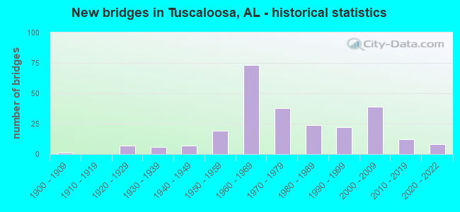
- New bridges - historical statistics
- 11900-1909
- 71920-1929
- 61930-1939
- 71940-1949
- 191950-1959
- 731960-1969
- 381970-1979
- 241980-1989
- 221990-1999
- 392000-2009
- 122010-2019
- 82020-2022
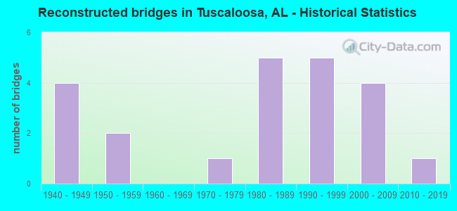
- Reconstructed bridges - Historical Statistics
- 41940-1949
- 21950-1959
- 01960-1969
- 11970-1979
- 51980-1989
- 51990-1999
- 42000-2009
- 12010-2019
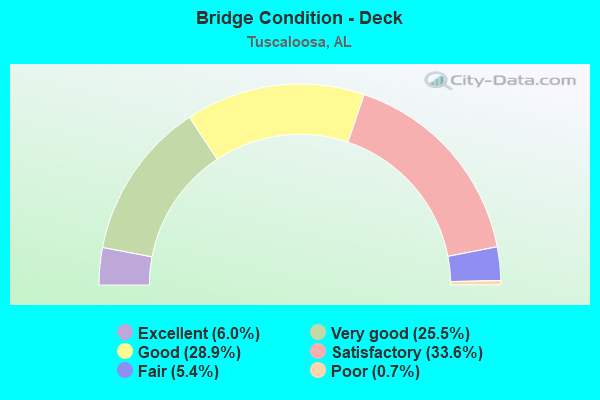
- Bridge Condition - Deck
- 6.0%Excellent
- 25.5%Very good
- 28.9%Good
- 33.6%Satisfactory
- 5.4%Fair
- 0.7%Poor
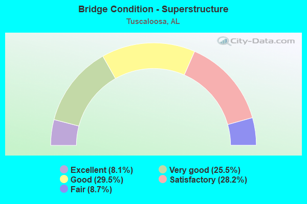
- Bridge Condition - Superstructure
- 8.1%Excellent
- 25.5%Very good
- 29.5%Good
- 28.2%Satisfactory
- 8.7%Fair
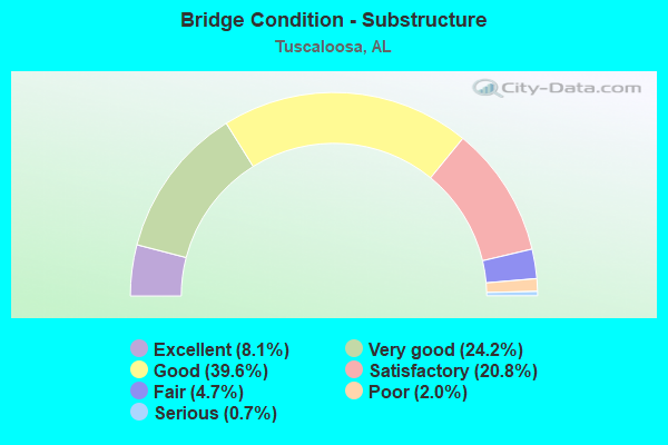
- Bridge Condition - Substructure
- 8.1%Excellent
- 24.2%Very good
- 39.6%Good
- 20.8%Satisfactory
- 4.7%Fair
- 2.0%Poor
- 0.7%Serious
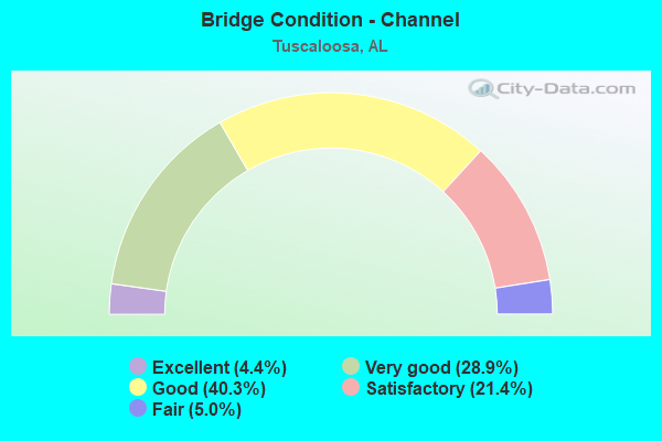
- Bridge Condition - Channel
- 4.4%Excellent
- 28.9%Very good
- 40.3%Good
- 21.4%Satisfactory
- 5.0%Fair
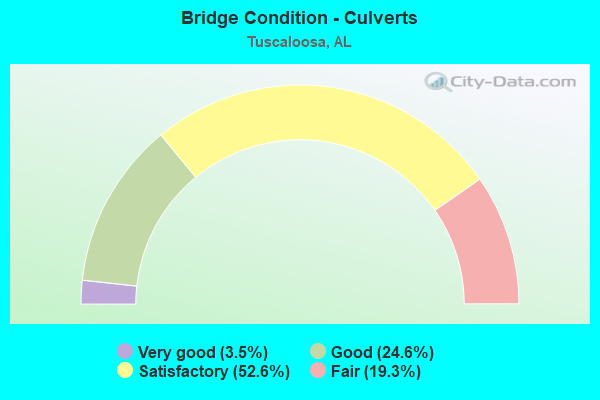
- Bridge Condition - Culverts
- 3.5%Very good
- 24.6%Good
- 52.6%Satisfactory
- 19.3%Fair
Find on map >> Show street view
Structure Number: 21284, Location: _5.1 MI NW OF US HY 43 (Lat: 33.422842, Lng: -87.643464), Route carried "on" structure: County highway 167, Year Built: 2016, Status: Open, Structure Length: 3.11m (10.20ft), Average Daily Traffic: 30 (year 2016), Truck Traffic: 3%, Average Future Daily Traffic: 50 (year 2034), Design Load: HS 20, Features Intersected: _GIN CREEK, Facility Carried by Structure: _HARLESS RD.
Minimum Vertical Clearance: 30+ m (98+ ft), Kilometerpoint: 0.010, Lanes on structure: 2, Toll: On toll road, Owner: County Highway Agency, Approaching Roadway Width: 9.1m (29.9ft), Material/Design: Concrete, Design/Construction: Channel Beam, Number Of Spans In Main Unit: 3, Length of Maximum Span: 10.4m (34.1ft), Curb-To-Curb Width: 6.1m (20.0ft), Out-to-Out Width: 9.3m (30.5ft)
Condition: Deck: Very good, Superstructure: Very good, Substructure: Good, Channel: Very good, Operating Rating: 70.7 metric tons, Method Used To Determine Operating Rating: Load Factor (LF), Inventory Rating: 42.5 metric tons, Method Used To Determine Inventory Rating: Load Factor (LF), Structural Evaluation: Better than present minimum criteria, Deck Geometry: Somewhat better than minimum adequacy, Waterway Adequacy: Equal to present desirable criteria, Approach Roadway Alignment: Somewhat better than minimum adequacy, Length Of Structure Improvement: 3.96m (12.99ft), Designated Inspection Frequency: Every 24 months, Inspection Date: June 2021, Bridge Improvement Cost: $815,000, Roadway Improvement Cost: $82,000, Total Project Cost: $897,000 ( Estimate for 2022), Deck Structure Type: Concrete Precast Panels, Wearing Surface/Protective System: Wearing Surface: Low Slump Concrete
Find on map >> Show street view
Structure Number: 21304, Location: OFF WATERMELON RD (Lat: 33.343800, Lng: -87.484300), Route carried "on" structure: County highway 928, Year Built: 2016, Status: Open, Structure Length: 1.04m (3.41ft), Average Daily Traffic: 10 (year 2016), Truck Traffic: 1%, Average Future Daily Traffic: 15 (year 2024), Design Load: HS 20, Features Intersected: _YELLOW CREEK, Facility Carried by Structure: _SPANE DR.
Minimum Vertical Clearance: 30+ m (98+ ft), Kilometerpoint: 0.010, Lanes on structure: 2, Owner: County Highway Agency, Approaching Roadway Width: 8.5m (27.9ft), Material/Design: Concrete, Design/Construction: Channel Beam, Number Of Spans In Main Unit: 1, Length of Maximum Span: 10.4m (34.1ft), Curb-To-Curb Width: 6.7m (22.0ft), Out-to-Out Width: 9.4m (30.8ft)
Condition: Deck: Very good, Superstructure: Very good, Substructure: Very good, Channel: Very good, Operating Rating: 70.7 metric tons, Method Used To Determine Operating Rating: Load Factor (LF), Inventory Rating: 42.5 metric tons, Method Used To Determine Inventory Rating: Load Factor (LF), Structural Evaluation: Equal to present desirable criteria, Deck Geometry: Somewhat better than minimum adequacy, Waterway Adequacy: Somewhat better than minimum adequacy, Approach Roadway Alignment: Meets minimum limits, Length Of Structure Improvement: 1.71m (5.61ft), Designated Inspection Frequency: Every 24 months, Inspection Date: November 2020, Bridge Improvement Cost: $363,000, Roadway Improvement Cost: $36,000, Total Project Cost: $399,000 ( Estimate for 2022), Deck Structure Type: Concrete Precast Panels
Find on map >> Show street view
Structure Number: 21349, Location: EXIT 73 (Lat: 33.171422, Lng: -87.525347), Route carried "on" structure: Interstate 59, Year Built: 2021, Status: Open, Structure Length: 7.83m (25.69ft), Average Daily Traffic: 55,431 (year 2020), Truck Traffic: 31%, Average Future Daily Traffic: 67,636 (year 2040), Design Load: HL 93, Features Intersected: SR-6 (US-82)
Minimum Vertical Clearance: 14.63m (48.00ft), Kilometerpoint: 117.421, Lanes on structure: 6, Lanes under structure: 10, Base Highway Network: Yes, Owner: State Highway Agency, Approaching Roadway Width: 38.7m (127.0ft), Skew: 32 degrees, Material/Design: Steel, Design/Construction: Arch - Thru, Number Of Spans In Main Unit: 1, Number Of Approach Spans: 2, Length of Maximum Span: 76.2m (250.0ft), Curb-To-Curb Width: 19.1m (62.7ft), Out-to-Out Width: 39.4m (129.3ft)
Condition: Deck: Very good, Superstructure: Excellent, Substructure: Excellent, Operating Rating: 43.5 metric tons, Method Used To Determine Operating Rating: No rating analysis performed, Inventory Rating: 32.7 metric tons, Method Used To Determine Inventory Rating: No rating analysis performed, Structural Evaluation: Superior to present desirable criteria, Deck Geometry: High priority of replacement, Underclear: Superior to present desirable criteria, Approach Roadway Alignment: Equal to present desirable criteria, Length Of Structure Improvement: 8.84m (29.00ft), Designated Inspection Frequency: Every 24 months, Inspection Date: May 2021, Bridge Improvement Cost: $7,820,000, Roadway Improvement Cost: $782,000, Total Project Cost: $8,602,000 ( Estimate for 2022), Deck Structure Type: Concrete Cast-file-Place
Find on map >> Show street view
Structure Number: 2135, Location: EXIT 76 (Lat: 33.174211, Lng: -87.474964), Route carried "on" structure: Interstate 59, Year Built: 2020, Status: Open, Structure Length: 10.67m (35.01ft), Average Daily Traffic: 50,190 (year 2016), Truck Traffic: 62%, Average Future Daily Traffic: 62,096 (year 2035), Design Load: HS 20, Features Intersected: US11/SR7, SKYLAND
Minimum Vertical Clearance: 30+ m (98+ ft), Kilometerpoint: 122.193, Lanes on structure: 6, Lanes under structure: 4, Base Highway Network: Yes, Owner: State Highway Agency, Approaching Roadway Width: 18.9m (62.0ft), Skew: 14 degrees, Material/Design: Prestressed concrete, Design/Construction: Stringer/Multi-beam, Number Of Spans In Main Unit: 2, Number Of Approach Spans: 2, Length of Maximum Span: 32.0m (105.0ft), Curb-To-Curb Width: 37.8m (124.0ft), Out-to-Out Width: 39.5m (129.6ft)
Condition: Deck: Very good, Superstructure: Excellent, Substructure: Excellent, Operating Rating: 83.2 metric tons, Method Used To Determine Operating Rating: Load Factor (LF), Inventory Rating: 46.9 metric tons, Method Used To Determine Inventory Rating: Load Factor (LF), Structural Evaluation: Superior to present desirable criteria, Deck Geometry: Superior to present desirable criteria, Underclear: High priority of corrective action, Approach Roadway Alignment: Equal to present desirable criteria, Length Of Structure Improvement: 11.57m (37.96ft), Designated Inspection Frequency: Every 24 months, Inspection Date: May 2021, Bridge Improvement Cost: $10,235,000, Roadway Improvement Cost: $1,024,000, Total Project Cost: $11,259,000 ( Estimate for 2022), Deck Structure Type: Concrete Cast-file-Place
Find on map >> Show street view
Structure Number: 21515, Location: 1.8 mi W of AL 69 (Lat: 33.114333, Lng: -87.580228), Route carried "on" structure: County highway 323, Year Built: 2019, Status: Open, Structure Length: 3.11m (10.20ft), Average Daily Traffic: 20 (year 2019), Average Future Daily Traffic: 50 (year 2030), Design Load: HS 20, Features Intersected: Duck Creek, Facility Carried by Structure: Maxwell Loop
Minimum Vertical Clearance: 6.10m (20.01ft), Kilometerpoint: 0.010, Lanes on structure: 2, Owner: County Highway Agency, Approaching Roadway Width: 6.1m (20.0ft), Material/Design: Concrete, Design/Construction: Channel Beam, Number Of Spans In Main Unit: 3, Length of Maximum Span: 10.4m (34.1ft), Curb-To-Curb Width: 8.5m (27.9ft), Out-to-Out Width: 9.3m (30.5ft)
Condition: Deck: Excellent, Superstructure: Excellent, Substructure: Excellent, Channel: Very good, Operating Rating: 51.8 metric tons, Method Used To Determine Operating Rating: Load Factor (LF), Inventory Rating: 28.3 metric tons, Method Used To Determine Inventory Rating: Load Factor (LF), Structural Evaluation: Better than present minimum criteria, Deck Geometry: Better than present minimum criteria, Waterway Adequacy: Equal to present desirable criteria, Approach Roadway Alignment: Better than present minimum criteria, Length Of Structure Improvement: 3.96m (12.99ft), Designated Inspection Frequency: Every 24 months, Inspection Date: December 2021, Bridge Improvement Cost: $815,000, Roadway Improvement Cost: $82,000, Total Project Cost: $897,000 ( Estimate for 2022), Deck Structure Type: Concrete Precast Panels
Find on map >> Show street view
Structure Number: 21521, Location: .1 mi. s. of Hargrove Rd. (Lat: 33.185583, Lng: -87.522567), Route carried "on" structure: City street 2, Year Built: 2019, Status: Open, Structure Length: 1.04m (3.41ft), Average Daily Traffic: 44 (year 2013), Truck Traffic: 1%, Average Future Daily Traffic: 60 (year 2036), Design Load: HS 20, Features Intersected: _CRIBBS MILL CREEK
Minimum Vertical Clearance: 30+ m (98+ ft), Kilometerpoint: 0.805, Lanes on structure: 2, Owner: City or Municipal Highway Agency, Approaching Roadway Width: 8.5m (27.9ft), Material/Design: Concrete, Design/Construction: Channel Beam, Number Of Spans In Main Unit: 1, Length of Maximum Span: 10.4m (34.1ft), Curb-To-Curb Width: 8.5m (27.9ft), Out-to-Out Width: 9.4m (30.8ft)
Condition: Deck: Excellent, Superstructure: Excellent, Substructure: Excellent, Channel: Excellent, Operating Rating: 51.8 metric tons, Method Used To Determine Operating Rating: Load Factor (LF), Inventory Rating: 31.0 metric tons, Method Used To Determine Inventory Rating: Load Factor (LF), Structural Evaluation: Better than present minimum criteria, Deck Geometry: Better than present minimum criteria, Waterway Adequacy: Equal to present desirable criteria, Approach Roadway Alignment: Equal to present desirable criteria, Length Of Structure Improvement: 1.71m (5.61ft), Designated Inspection Frequency: Every 24 months, Inspection Date: November 2020, Bridge Improvement Cost: $363,000, Roadway Improvement Cost: $36,000, Total Project Cost: $399,000 ( Estimate for 2022), Deck Structure Type: Concrete Precast Panels
Find on map >> Show street view
Structure Number: 21522, Location: .2 Mi E. of McFarland (Lat: 33.186925, Lng: -87.521800), Route carried "on" structure: City street 2, Year Built: 2019, Status: Open, Structure Length: 1.04m (3.41ft), Average Daily Traffic: 2,390 (year 2013), Average Future Daily Traffic: 4,290 (year 2036), Design Load: HL 93, Features Intersected: _CRIBBS MILL CREEK
Minimum Vertical Clearance: 30+ m (98+ ft), Kilometerpoint: 1.609, Lanes on structure: 5, Owner: City or Municipal Highway Agency, Approaching Roadway Width: 18.7m (61.4ft), Skew: 1 degrees, Material/Design: Prestressed concrete continuous, Design/Construction: Stringer/Multi-beam, Number Of Spans In Main Unit: 1, Length of Maximum Span: 9.4m (30.8ft), Curb or Sidewalk Widths: Left: 2.7m (8.9ft), Right: 1.8m (5.9ft), Curb-To-Curb Width: 18.7m (61.4ft), Out-to-Out Width: 25.0m (82.0ft)
Condition: Deck: Excellent, Superstructure: Excellent, Substructure: Excellent, Channel: Excellent, Operating Rating: 88.9 metric tons, Method Used To Determine Operating Rating: Load and Resistance Factor (LRFR), Inventory Rating: 88.9 metric tons, Method Used To Determine Inventory Rating: Load and Resistance Factor (LRFR), Structural Evaluation: Superior to present desirable criteria, Deck Geometry: High priority of corrective action, Waterway Adequacy: Equal to present desirable criteria, Approach Roadway Alignment: Equal to present desirable criteria, Length Of Structure Improvement: 1.71m (5.61ft), Designated Inspection Frequency: Every 24 months, Inspection Date: November 2020, Bridge Improvement Cost: $960,000, Roadway Improvement Cost: $96,000, Total Project Cost: $1,056,000 ( Estimate for 2022), Deck Structure Type: Concrete Cast-file-Place
Find on map >> Show street view
Structure Number: 21591, Location: _.2 Mi N. J. Harrison (Lat: 33.177361, Lng: -87.525861), Route carried "on" structure: City street 43, Year Built: 2021, Status: Open, Structure Length: 1.56m (5.12ft), Average Daily Traffic: 2,016 (year 2001), Truck Traffic: 1%, Average Future Daily Traffic: 3,350 (year 2030), Design Load: HL 93, Features Intersected: _CRIBBS MILL CREEK, Facility Carried by Structure: _ALBRIGHT RD
Minimum Vertical Clearance: 30+ m (98+ ft), Kilometerpoint: 0.000, Lanes on structure: 2, Owner: City or Municipal Highway Agency, Approaching Roadway Width: 7.3m (24.0ft), Skew: 3 degrees, Material/Design: Prestressed concrete, Design/Construction: Stringer/Multi-beam, Number Of Spans In Main Unit: 1, Length of Maximum Span: 15.0m (49.2ft), Curb-To-Curb Width: 7.9m (25.9ft), Out-to-Out Width: 8.6m (28.2ft)
Condition: Deck: Excellent, Superstructure: Excellent, Substructure: Excellent, Channel: Satisfactory, Operating Rating: 88.9 metric tons, Method Used To Determine Operating Rating: Load and Resistance Factor (LRFR), Inventory Rating: 88.9 metric tons, Method Used To Determine Inventory Rating: Load and Resistance Factor (LRFR), Structural Evaluation: Superior to present desirable criteria, Deck Geometry: High priority of corrective action, Waterway Adequacy: Equal to present minimum criteria, Approach Roadway Alignment: Better than present minimum criteria, Length Of Structure Improvement: 2.24m (7.35ft), Designated Inspection Frequency: Every 24 months, Inspection Date: March 2021, Bridge Improvement Cost: $431,000, Roadway Improvement Cost: $43,000, Total Project Cost: $474,000 ( Estimate for 2022), Deck Structure Type: Concrete Cast-file-Place
Find on map >> Show street view
Structure Number: 21592, Location: .3 Mi. N. J. Harrison (Lat: 33.178306, Lng: -87.525861), Route carried "on" structure: City street 43, Year Built: 2020, Status: Open, Structure Length: 1.04m (3.41ft), Average Daily Traffic: 2,100 (year 2020), Truck Traffic: 1%, Average Future Daily Traffic: 3,300 (year 2030), Design Load: HS 20, Features Intersected: CRIBBS MILL CREEK, Facility Carried by Structure: ALBRIGHT RD
Minimum Vertical Clearance: 30+ m (98+ ft), Kilometerpoint: 0.000, Lanes on structure: 2, Owner: City or Municipal Highway Agency, Approaching Roadway Width: 8.5m (27.9ft), Number Of Spans In Main Unit: 1, Length of Maximum Span: 9.1m (29.9ft), Curb-To-Curb Width: 8.5m (27.9ft), Out-to-Out Width: 9.3m (30.5ft)
Condition: Deck: Very good, Superstructure: Very good, Substructure: Excellent, Channel: Satisfactory, Operating Rating: 39.5 metric tons, Method Used To Determine Operating Rating: Load Factor (LF), Inventory Rating: 23.7 metric tons, Method Used To Determine Inventory Rating: Load Factor (LF), Structural Evaluation: Equal to present minimum criteria, Deck Geometry: Meets minimum limits, Waterway Adequacy: Equal to present minimum criteria, Approach Roadway Alignment: Equal to present desirable criteria, Length Of Structure Improvement: 1.71m (5.61ft), Designated Inspection Frequency: Every 24 months, Inspection Date: November 2020, Bridge Improvement Cost: $351,000, Roadway Improvement Cost: $35,000, Total Project Cost: $386,000 ( Estimate for 2022), Deck Structure Type: Concrete Precast Panels
Find on map >> Show street view
Structure Number: 21607, Location: 0.25 miles S of Bryant DR (Lat: 33.200525, Lng: -87.537372), Route carried "on" structure: City street , Year Built: 2021, Status: Open, Structure Length: 22.89m (75.10ft), Average Daily Traffic: 1,500 (year 2021), Truck Traffic: 10%, Average Future Daily Traffic: 2,500 (year 2041), Design Load: HS 20, Features Intersected: Great Southern Railroad, Facility Carried by Structure: 2nd Avenue
Minimum Vertical Clearance: 30.48m (100.00ft), Kilometerpoint: 0.435, Lanes on structure: 3, Owner: State Agenciy, Approaching Roadway Width: 10.7m (35.1ft), Skew: 10 degrees, Material/Design: Concrete, Design/Construction: Stringer/Multi-beam, Number Of Spans In Main Unit: 1, Length of Maximum Span: 38.1m (125.0ft), Curb or Sidewalk Widths: Left: 0.0m, Right: 3.7m (12.1ft), Curb-To-Curb Width: 10.7m (35.1ft), Out-to-Out Width: 17.0m (55.8ft)
Condition: Deck: Excellent, Superstructure: Excellent, Substructure: Excellent, Operating Rating: 88.9 metric tons, Method Used To Determine Operating Rating: Load Factor (LF), Inventory Rating: 44.4 metric tons, Method Used To Determine Inventory Rating: Load Factor (LF), Structural Evaluation: Superior to present desirable criteria, Deck Geometry: High priority of replacement, Underclear: Superior to present desirable criteria, Approach Roadway Alignment: Equal to present desirable criteria, Length Of Structure Improvement: 22.89m (75.10ft), Designated Inspection Frequency: Every 24 months, Inspection Date: June 2021, Bridge Improvement Cost: $8,633,000, Roadway Improvement Cost: $863,000, Total Project Cost: $9,496,000 ( Estimate for 2022), Deck Structure Type: Concrete Cast-file-Place
Find on map >> Show street view
Structure Number: 6554, Location: 0.5 MI W JCT SR 215 (Lat: 33.215367, Lng: -87.528353), Route carried "under" structure: City street , Year Built: 1959, Structure Length: 0. m, Average Daily Traffic: 10,417 (year 2008), Truck Traffic: 2%, Features Intersected: L * N RR, CAMPUS DR, Facility Carried by Structure: US 82
Minimum Vertical Clearance: 5.23m (17.16ft), Kilometerpoint: 0.000, Lanes on structure: 2, Lanes under structure: 2, Material/Design: Concrete, Design/Construction: Tee Beam, Length of Maximum Span: 15.2m (49.9ft)
Find on map >> Show street view
Structure Number: 6555, Location: 0.5 MI W JCT SR 215 (Lat: 33.215306, Lng: -87.528600), Route carried "under" structure: City street , Year Built: 1959, Structure Length: 0. m, Average Daily Traffic: 10,417 (year 2008), Truck Traffic: 2%, Features Intersected: L * N RR, CAMPUS DR, Facility Carried by Structure: US 82
Minimum Vertical Clearance: 5.49m (18.01ft), Kilometerpoint: 0.000, Lanes on structure: 2, Lanes under structure: 2, Material/Design: Concrete, Design/Construction: Tee Beam, Length of Maximum Span: 15.2m (49.9ft)
Find on map >> Show street view
Structure Number: 6932, Location: 0.34 MI W OF JACK WARNER (Lat: 33.222022, Lng: -87.531981), Route carried "under" structure: City street , Year Built: 1960, Structure Length: 0. m, Average Daily Traffic: 10,000 (year 2010), Truck Traffic: 1%, Features Intersected: WARRIOR RVR, RICE MINE R, Facility Carried by Structure: US 82
Minimum Vertical Clearance: 10.18m (33.40ft), Kilometerpoint: 0.000, Lanes on structure: 4, Lanes under structure: 3, Material/Design: Steel continuous, Design/Construction: Girder and Floorbeam System, Length of Maximum Span: 79.2m (259.8ft)
Find on map >> Show street view
Structure Number: 7691, Location: STAFFARD ELEM. SCHOOL (Lat: 33.199389, Lng: -87.555694), Route carried "under" structure: City street , Year Built: 1962, Structure Length: 0. m, Average Daily Traffic: 2,486 (year 1993), Truck Traffic: 3%, Features Intersected: GM&O - NOR SO RR Active, Facility Carried by Structure: SR 215
Minimum Vertical Clearance: 4.62m (15.16ft), Kilometerpoint: 0.750, Lanes on structure: 4, Lanes under structure: 2, Material/Design: Concrete continuous, Design/Construction: Tee Beam, Length of Maximum Span: 30.5m (100.1ft)
Find on map >> Show street view
Structure Number: 7691, Location: STAFFARD ELEM. SCHOOL (Lat: 33.199389, Lng: -87.555694), Route carried "under" structure: City street , Year Built: 1962, Structure Length: 0. m, Average Daily Traffic: 300 (year 1993), Truck Traffic: 3%, Features Intersected: GM&O - NOR SO RR Active, Facility Carried by Structure: SR 215
Minimum Vertical Clearance: 6.65m (21.82ft), Kilometerpoint: 0.200, Lanes on structure: 4, Lanes under structure: 1, Material/Design: Concrete continuous, Design/Construction: Tee Beam, Length of Maximum Span: 30.5m (100.1ft)
Find on map >> Show street view
Structure Number: 8152, Location: 2.3 MI N US 11 (Lat: 33.180992, Lng: -87.369903), Route carried "under" structure: Interstate 20, Year Built: 1964, Structure Length: 0. m, Average Daily Traffic: 47,400 (year 2015), Truck Traffic: 32%, Features Intersected: I-59, I-20, Facility Carried by Structure: CR 32 KEENES MILL
Minimum Vertical Clearance: 5.61m (18.41ft), Kilometerpoint: 132.161, Lanes on structure: 2, Lanes under structure: 4, Material/Design: Concrete continuous, Design/Construction: Tee Beam, Length of Maximum Span: 29.3m (96.1ft)
Find on map >> Show street view
Structure Number: 8155, Location: 1.6 MI S BROOKWOOD RD (Lat: 33.188200, Lng: -87.328800), Route carried "under" structure: Interstate 20, Year Built: 1964, Structure Length: 0. m, Average Daily Traffic: 47,400 (year 2015), Truck Traffic: 32%, Features Intersected: I-59, I-20, Facility Carried by Structure: ED STEPHENS RD
Minimum Vertical Clearance: 5.58m (18.31ft), Kilometerpoint: 136.120, Lanes on structure: 2, Lanes under structure: 8, Material/Design: Concrete continuous, Design/Construction: Tee Beam, Length of Maximum Span: 20.7m (67.9ft)
Find on map >> Show street view
Structure Number: 8157, Location: 2.0 MI W CEDAR COVE (Lat: 33.188803, Lng: -87.301244), Route carried "under" structure: Interstate 20, Year Built: 1964, Structure Length: 0. m, Average Daily Traffic: 47,400 (year 2015), Truck Traffic: 32%, Features Intersected: I-59, I-20, Facility Carried by Structure: CR59 BROOKWOOD EXT
Minimum Vertical Clearance: 5.58m (18.31ft), Kilometerpoint: 138.742, Lanes on structure: 2, Lanes under structure: 6, Material/Design: Concrete continuous, Design/Construction: Tee Beam, Length of Maximum Span: 25.9m (85.0ft)
Find on map >> Show street view
Structure Number: 8158, Location: 2.2 MI N BROOKWOOD RD (Lat: 33.189064, Lng: -87.264947), Route carried "under" structure: County highway , Year Built: 1964, Structure Length: 0. m, Average Daily Traffic: 827 (year 2009), Truck Traffic: 15%, Features Intersected: COUNTY ROAD, Facility Carried by Structure: I-20
Minimum Vertical Clearance: 5.27m (17.29ft), Kilometerpoint: 0.000, Lanes on structure: 2, Lanes under structure: 3, Material/Design: Concrete, Design/Construction: Tee Beam, Length of Maximum Span: 16.8m (55.1ft)
Find on map >> Show street view
Structure Number: 8159, Location: 2.2 MI N BROOKWOOD RD (Lat: 33.190258, Lng: -87.264528), Route carried "under" structure: County highway , Year Built: 1964, Structure Length: 0. m, Average Daily Traffic: 1,000 (year 2009), Truck Traffic: 15%, Features Intersected: COUNTY ROAD, Facility Carried by Structure: I-20
Minimum Vertical Clearance: 5.30m (17.39ft), Kilometerpoint: 0.000, Lanes on structure: 2, Lanes under structure: 3, Material/Design: Concrete, Design/Construction: Tee Beam, Length of Maximum Span: 16.8m (55.1ft)
Find on map >> Show street view
Structure Number: 898, Location: 1.7 MI S HAMMS POTTERY (Lat: 33.171347, Lng: -87.436558), Route carried "under" structure: Interstate 20, Year Built: 1966, Structure Length: 0. m, Average Daily Traffic: 45,680 (year 2013), Truck Traffic: 32%, Features Intersected: I-59, I-20, Facility Carried by Structure: CO RD 77
Minimum Vertical Clearance: 5.85m (19.19ft), Kilometerpoint: 125.749, Lanes on structure: 2, Lanes under structure: 4, Material/Design: Concrete continuous, Design/Construction: Tee Beam, Length of Maximum Span: 25.0m (82.0ft)
Find on map >> Show street view
Structure Number: 962, Location: SKYLAND SCHOOL (Lat: 33.167600, Lng: -87.531300), Route carried "under" structure: US 11, Year Built: 1968, Structure Length: 0. m, Average Daily Traffic: 25,070 (year 2013), Truck Traffic: 4%, Features Intersected: US 11, Facility Carried by Structure: PEDESTRIAN OVERPAS
Minimum Vertical Clearance: 5.16m (16.93ft), Kilometerpoint: 130.698, Lanes under structure: 4, Material/Design: Steel continuous, Design/Construction: Stringer/Multi-beam, Length of Maximum Span: 18.0m (59.1ft)
Find on map >> Show street view
Structure Number: 9887, Location: 2.2 MI N WARRIOR RIVER (Lat: 33.137864, Lng: -87.630683), Route carried "under" structure: Interstate 20, Year Built: 1969, Structure Length: 0. m, Average Daily Traffic: 26,470 (year 2013), Truck Traffic: 35%, Features Intersected: I-59, I-20, Facility Carried by Structure: CO RD (Gee Lane)
Minimum Vertical Clearance: 5.00m (16.40ft), Kilometerpoint: 106.690, Lanes on structure: 2, Lanes under structure: 4, Material/Design: Steel continuous, Design/Construction: Stringer/Multi-beam, Length of Maximum Span: 27.7m (90.9ft)
Find on map >> Show street view
Structure Number: 9903, Location: JCT I59 (Lat: 33.175681, Lng: -87.502461), Route carried "under" structure: Interstate 20, Year Built: 1969, Structure Length: 0. m, Average Daily Traffic: 50,190 (year 2013), Truck Traffic: 31%, Features Intersected: I-59, I-20, Facility Carried by Structure: CR37 HARGROVE RD
Minimum Vertical Clearance: 5.18m (16.99ft), Kilometerpoint: 119.573, Lanes on structure: 2, Lanes under structure: 4, Material/Design: Concrete continuous, Design/Construction: Tee Beam, Length of Maximum Span: 32.0m (105.0ft)
Find on map >> Show street view
Structure Number: 9904, Location: JCT I-59 (Lat: 33.175633, Lng: -87.489933), Route carried "under" structure: Interstate 20, Year Built: 1969, Structure Length: 0. m, Average Daily Traffic: 50,190 (year 2015), Truck Traffic: 31%, Features Intersected: I-59, I-20, Facility Carried by Structure: WOODLAND ROAD
Minimum Vertical Clearance: 5.24m (17.19ft), Kilometerpoint: 120.796, Lanes on structure: 2, Lanes under structure: 4, Material/Design: Concrete continuous, Design/Construction: Tee Beam, Length of Maximum Span: 20.7m (67.9ft)
Find on map >> Show street view
Structure Number: 10161, Location: 0.3 MI N JCT SKYLAND BLVD (Lat: 33.169667, Lng: -87.552833), Route carried "under" structure: Spur Interstate 20, Year Built: 1970, Structure Length: 0. m, Average Daily Traffic: 15,645 (year 2013), Truck Traffic: 35%, Features Intersected: I 59,I 20, Facility Carried by Structure: I-359
Minimum Vertical Clearance: 5.85m (19.19ft), Kilometerpoint: 114.815, Lanes on structure: 3, Lanes under structure: 6, Material/Design: Concrete continuous, Design/Construction: Tee Beam, Length of Maximum Span: 25.9m (85.0ft)
Find on map >> Show street view
Structure Number: 10162, Location: 0.3 MI N JCT SKYLAND BLVD (Lat: 33.169833, Lng: -87.552500), Route carried "under" structure: Spur Interstate 20, Year Built: 1970, Structure Length: 0. m, Average Daily Traffic: 15,645 (year 2013), Truck Traffic: 35%, Features Intersected: I 59,I-20, Facility Carried by Structure: I-359
Minimum Vertical Clearance: 6.10m (20.01ft), Kilometerpoint: 114.840, Lanes on structure: 3, Lanes under structure: 6, Material/Design: Concrete continuous, Design/Construction: Tee Beam, Length of Maximum Span: 25.9m (85.0ft)
Find on map >> Show street view
Structure Number: 10181, Location: 2.5 MI S JCT I-359 (Lat: 33.155333, Lng: -87.588050), Route carried "under" structure: Interstate 20, Year Built: 1970, Structure Length: 0. m, Average Daily Traffic: 31,290 (year 2013), Truck Traffic: 35%, Features Intersected: I-59, I-20, Facility Carried by Structure: CR (ST BUNN)
Minimum Vertical Clearance: 5.06m (16.60ft), Kilometerpoint: 111.157, Lanes on structure: 2, Lanes under structure: 4, Material/Design: Steel continuous, Design/Construction: Stringer/Multi-beam, Length of Maximum Span: 25.3m (83.0ft)
Find on map >> Show street view
Structure Number: 10182, Location: 0.3 MI S JCT I-359 (Lat: 33.167811, Lng: -87.558283), Route carried "under" structure: City street , Year Built: 1970, Structure Length: 0. m, Average Daily Traffic: 5,500 (year 2009), Truck Traffic: 1%, Features Intersected: AL-SOUTH RR* KAULOOSA, Facility Carried by Structure: I-20
Minimum Vertical Clearance: 6.00m (19.69ft), Kilometerpoint: 0.000, Lanes on structure: 3, Lanes under structure: 2, Material/Design: Concrete continuous, Design/Construction: Tee Beam, Length of Maximum Span: 20.7m (67.9ft)
Find on map >> Show street view
Structure Number: 10183, Location: 0.3 MI S JCT I-359 (Lat: 33.167653, Lng: -87.558008), Route carried "under" structure: City street , Year Built: 1970, Structure Length: 0. m, Average Daily Traffic: 5,066 (year 2009), Truck Traffic: 1%, Features Intersected: GM*0 RR * KAULOOSA AVE, Facility Carried by Structure: I-20
Minimum Vertical Clearance: 6.10m (20.01ft), Kilometerpoint: 0.000, Lanes on structure: 2, Lanes under structure: 2, Material/Design: Concrete continuous, Design/Construction: Tee Beam, Length of Maximum Span: 20.7m (67.9ft)
Find on map >> Show street view
Structure Number: 10184, Location: SKYLAND SCHOOL (Lat: 33.170514, Lng: -87.532281), Route carried "under" structure: Interstate 20, Year Built: 1970, Structure Length: 0. m, Average Daily Traffic: 50,980 (year 2013), Truck Traffic: 31%, Features Intersected: I-59, I-20, Facility Carried by Structure: THIRD AVENUE
Minimum Vertical Clearance: 5.55m (18.21ft), Kilometerpoint: 116.254, Lanes on structure: 2, Lanes under structure: 6, Material/Design: Steel continuous, Design/Construction: Stringer/Multi-beam, Length of Maximum Span: 25.6m (84.0ft)
Find on map >> Show street view
Structure Number: 10278, Location: 0.2 MI E WARRIOR RIVER (Lat: 33.220100, Lng: -87.531500), Route carried "under" structure: US 82, Year Built: 1970, Structure Length: 0. m, Average Daily Traffic: 44,260 (year 2013), Truck Traffic: 5%, Features Intersected: US 82, Facility Carried by Structure: JACK WARNER PKWY
Minimum Vertical Clearance: 5.64m (18.50ft), Kilometerpoint: 79.951, Lanes on structure: 6, Lanes under structure: 6, Material/Design: Steel continuous, Design/Construction: Stringer/Multi-beam, Length of Maximum Span: 24.4m (80.1ft)
Find on map >> Show street view
Structure Number: 10279, Location: 0.2 MI E JCT SR 215 (Lat: 33.201950, Lng: -87.525133), Route carried "under" structure: US 82, Year Built: 1970, Structure Length: 0. m, Average Daily Traffic: 45,130 (year 2013), Truck Traffic: 5%, Features Intersected: US 82, Facility Carried by Structure: NORFOLK SO Active
Minimum Vertical Clearance: 5.24m (17.19ft), Kilometerpoint: 82.162, Lanes under structure: 6, Material/Design: Steel, Design/Construction: Stringer/Multi-beam, Length of Maximum Span: 16.2m (53.1ft)
Find on map >> Show street view
Structure Number: 1028, Location: 0.1 MI E JCT SR 215 (Lat: 33.202217, Lng: -87.525117), Route carried "under" structure: US 82, Year Built: 1970, Structure Length: 0. m, Average Daily Traffic: 45,130 (year 2013), Truck Traffic: 5%, Features Intersected: US 82, Facility Carried by Structure: GM&O RR Active
Minimum Vertical Clearance: 5.39m (17.68ft), Kilometerpoint: 82.131, Lanes under structure: 6, Material/Design: Steel, Design/Construction: Stringer/Multi-beam, Length of Maximum Span: 16.2m (53.1ft)
Find on map >> Show street view
Structure Number: 10427, Location: 0.5 MI N JCT US 11 BYPASS (Lat: 33.170764, Lng: -87.546361), Route carried "under" structure: Interstate 20, Year Built: 1970, Structure Length: 0. m, Average Daily Traffic: 50,980 (year 2013), Truck Traffic: 31%, Features Intersected: I-59, Facility Carried by Structure: AL 215
Minimum Vertical Clearance: 5.87m (19.26ft), Kilometerpoint: 115.429, Lanes on structure: 4, Lanes under structure: 7, Material/Design: Steel continuous, Design/Construction: Stringer/Multi-beam, Length of Maximum Span: 26.2m (86.0ft)
Find on map >> Show street view
Structure Number: 10428, Location: DCH MEDICAL CENTER (Lat: 33.206150, Lng: -87.524550), Route carried "under" structure: US 82, Year Built: 1970, Structure Length: 0. m, Average Daily Traffic: 45,530 (year 2013), Truck Traffic: 5%, Features Intersected: US 82,SR 6,MCFARLAND BD., Facility Carried by Structure: UNIVERSITY BLVD.
Minimum Vertical Clearance: 5.33m (17.49ft), Kilometerpoint: 81.663, Lanes on structure: 6, Lanes under structure: 6, Material/Design: Concrete, Design/Construction: Tee Beam, Length of Maximum Span: 15.8m (51.8ft)
Find on map >> Show street view
Structure Number: 11406, Location: 0.5 MI E JCT US 11 (Lat: 33.161686, Lng: -87.525303), Route carried "under" structure: US 82, Year Built: 1975, Structure Length: 0. m, Average Daily Traffic: 16,260 (year 2013), Truck Traffic: 15%, Features Intersected: US 82,SR 6, Facility Carried by Structure: 51 STREET
Minimum Vertical Clearance: 5.33m (17.49ft), Kilometerpoint: 86.647, Lanes on structure: 2, Lanes under structure: 4, Material/Design: Steel continuous, Design/Construction: Stringer/Multi-beam, Length of Maximum Span: 24.4m (80.1ft)
Find on map >> Show street view
Structure Number: 11425, Location: ARCADIA SCHOOL (Lat: 33.195917, Lng: -87.488500), Route carried "under" structure: City street , Year Built: 1975, Structure Length: 0. m, Average Daily Traffic: 9,800 (year 1984), Truck Traffic: 1%, Features Intersected: PEDESTRIAN OVERPASS, Facility Carried by Structure: PEDESTRIAN OVERPAS
Minimum Vertical Clearance: 5.33m (17.49ft), Kilometerpoint: 0.000, Lanes under structure: 6, Material/Design: Steel continuous, Design/Construction: Stringer/Multi-beam, Length of Maximum Span: 35.1m (115.2ft)
Find on map >> Show street view
Structure Number: 11426, Location: 15TH STREET * LOOP ROAD (Lat: 33.195633, Lng: -87.485583), Route carried "under" structure: Ramp City street , Year Built: 1975, Structure Length: 0. m, Average Daily Traffic: 6,805 (year 2013), Truck Traffic: 12%, Features Intersected: NORFORK & SO RR Active, Facility Carried by Structure: SR 215
Minimum Vertical Clearance: 5.36m (17.59ft), Kilometerpoint: 0.200, Lanes on structure: 5, Lanes under structure: 1, Material/Design: Steel, Design/Construction: Stringer/Multi-beam, Length of Maximum Span: 26.5m (86.9ft)
Find on map >> Show street view
Structure Number: 12489, Location: JCT I-359 * I-59 (Lat: 33.168600, Lng: -87.553800), Route carried "under" structure: Ramp Interstate 20, Year Built: 1981, Structure Length: 0. m, Average Daily Traffic: 3,129 (year 2013), Truck Traffic: 35%, Features Intersected: I-359,I-59,I-20,US 11, Facility Carried by Structure: I-359 RAMP
Minimum Vertical Clearance: 6.00m (19.69ft), Kilometerpoint: 114.646, Lanes on structure: 2, Lanes under structure: 4, Material/Design: Steel continuous, Design/Construction: Stringer/Multi-beam, Length of Maximum Span: 32.6m (107.0ft)
Find on map >> Show street view
Structure Number: 12489, Location: JCT I-359 * I-59 (Lat: 33.168600, Lng: -87.553800), Route carried "under" structure: Ramp Interstate 359, Year Built: 1981, Structure Length: 0. m, Average Daily Traffic: 4,073 (year 2013), Truck Traffic: 10%, Features Intersected: I-359,I-59,I-20,US 11
Minimum Vertical Clearance: 5.72m (18.77ft), Kilometerpoint: 0.393, Lanes on structure: 2, Lanes under structure: 4, Material/Design: Steel continuous, Design/Construction: Stringer/Multi-beam, Length of Maximum Span: 32.6m (107.0ft)
Find on map >> Show street view
Structure Number: 12693, Location: 1.1 MI N JCT SKYLAND BLVD (Lat: 33.179000, Lng: -87.556833), Route carried "under" structure: Ramp Interstate 359, Year Built: 1982, Structure Length: 0. m, Average Daily Traffic: 5,119 (year 2013), Truck Traffic: 10%, Features Intersected: I-359,US 11,SR 69,SR 7, Facility Carried by Structure: 35TH STREET
Minimum Vertical Clearance: 5.24m (17.19ft), Kilometerpoint: 1.640, Lanes on structure: 6, Lanes under structure: 8, Material/Design: Steel continuous, Design/Construction: Stringer/Multi-beam, Length of Maximum Span: 29.0m (95.1ft)
Find on map >> Show street view
Structure Number: 12694, Location: 1.3 MI N JCT SKYLAND BLVD (Lat: 33.183167, Lng: -87.557833), Route carried "under" structure: Interstate 359, Year Built: 1982, Structure Length: 0. m, Average Daily Traffic: 51,330 (year 2013), Truck Traffic: 10%, Features Intersected: I-359,US 11,SR 69,SR 11, Facility Carried by Structure: 31ST STREET
Minimum Vertical Clearance: 5.46m (17.91ft), Kilometerpoint: 2.147, Lanes on structure: 2, Lanes under structure: 8, Material/Design: Steel continuous, Design/Construction: Stringer/Multi-beam, Length of Maximum Span: 28.0m (91.9ft)
Find on map >> Show street view
Structure Number: 12907, Location: 1.8 MI N JCT SKYLAND BLVD (Lat: 33.189667, Lng: -87.560500), Route carried "under" structure: Spur US 11, Year Built: 1983, Structure Length: 0. m, Average Daily Traffic: 22,010 (year 2013), Truck Traffic: 6%, Features Intersected: US 43,US 11, Facility Carried by Structure: I-359
Minimum Vertical Clearance: 5.85m (19.19ft), Kilometerpoint: 124.784, Lanes on structure: 6, Lanes under structure: 15, Material/Design: Steel, Design/Construction: Stringer/Multi-beam, Length of Maximum Span: 38.4m (126.0ft)
Find on map >> Show street view
Structure Number: 12956, Location: CENTRAL ELEMENTARY SCHOOL (Lat: 33.200500, Lng: -87.575867), Route carried "under" structure: US 11, Year Built: 1983, Structure Length: 0. m, Average Daily Traffic: 21,550 (year 2013), Truck Traffic: 6%, Features Intersected: US 11, Facility Carried by Structure: PEDESTRIAN OVERPAS
Minimum Vertical Clearance: 5.33m (17.49ft), Kilometerpoint: 123.903, Lanes under structure: 7, Material/Design: Steel, Design/Construction: Stringer/Multi-beam, Length of Maximum Span: 33.5m (109.9ft)
Find on map >> Show street view
Structure Number: 12957, Location: 0.1 MI W OF I-359 (Lat: 33.199800, Lng: -87.568300), Route carried "under" structure: City street , Year Built: 1983, Structure Length: 0. m, Average Daily Traffic: 500 (year 2002), Truck Traffic: 6%, Features Intersected: ICG RR * 27TH AVENUE, Facility Carried by Structure: US 11
Minimum Vertical Clearance: 8.31m (27.26ft), Kilometerpoint: 0.000, Lanes on structure: 6, Lanes under structure: 2, Material/Design: Steel, Design/Construction: Stringer/Multi-beam, Length of Maximum Span: 46.3m (151.9ft)
Find on map >> Show street view
Structure Number: 14782, Location: 1.6 MI N OF COTTONDALE (Lat: 33.172381, Lng: -87.447553), Route carried "under" structure: Interstate 20, Year Built: 1989, Structure Length: 0. m, Average Daily Traffic: 46,750 (year 2013), Truck Traffic: 32%, Features Intersected: I-59, I-20, Facility Carried by Structure: CO RD 85BUTTERMILK
Minimum Vertical Clearance: 5.55m (18.21ft), Kilometerpoint: 124.763, Lanes on structure: 3, Lanes under structure: 4, Material/Design: Prestressed concrete continuous, Design/Construction: Stringer/Multi-beam, Length of Maximum Span: 26.2m (86.0ft)
Find on map >> Show street view
Structure Number: 16585, Location: 3.0 MI N CO RD 59 (Lat: 33.193400, Lng: -87.250050), Route carried "under" structure: Interstate 20, Year Built: 1995, Structure Length: 0. m, Average Daily Traffic: 23,785 (year 2015), Truck Traffic: 32%, Features Intersected: I-59, I-20, Facility Carried by Structure: M-CLASS BLVD
Minimum Vertical Clearance: 5.49m (18.01ft), Kilometerpoint: 143.639, Lanes on structure: 2, Lanes under structure: 3, Material/Design: Prestressed concrete, Design/Construction: Stringer/Multi-beam, Length of Maximum Span: 42.1m (138.1ft)
Find on map >> Show street view
Structure Number: 16586, Location: 3.0 MI N CO RD 59 (Lat: 33.192333, Lng: -87.249683), Route carried "under" structure: Interstate 20, Year Built: 1995, Structure Length: 0. m, Average Daily Traffic: 23,785 (year 2015), Truck Traffic: 32%, Features Intersected: I-59, I-20, Facility Carried by Structure: M-CLASS BLVD
Minimum Vertical Clearance: 5.39m (17.68ft), Kilometerpoint: 143.639, Lanes on structure: 2, Lanes under structure: 3, Material/Design: Prestressed concrete, Design/Construction: Stringer/Multi-beam, Length of Maximum Span: 42.1m (138.1ft)
Find on map >> Show street view
Structure Number: 16971, Location: 4.5 MI S BIBB CO LINE (Lat: 33.173700, Lng: -87.265017), Route carried "under" structure: US 11, Year Built: 1997, Structure Length: 0. m, Average Daily Traffic: 6,450 (year 2013), Truck Traffic: 9%, Features Intersected: SR-7 (US-11), Facility Carried by Structure: NS RR
Minimum Vertical Clearance: 9.85m (32.32ft), Kilometerpoint: 158.083, Lanes under structure: 2, Material/Design: Steel, Design/Construction: Stringer/Multi-beam, Length of Maximum Span: 50.6m (166.0ft)
Find on map >> Show street view
Structure Number: 17056, Location: 3.2MI S JCT I 359 (Lat: 33.152633, Lng: -87.599233), Route carried "under" structure: Interstate 20, Year Built: 1998, Structure Length: 0. m, Average Daily Traffic: 26,470 (year 2013), Truck Traffic: 35%, Features Intersected: I-59/I-20, Facility Carried by Structure: BLACK WARRIOR PKWY
Minimum Vertical Clearance: 5.43m (17.81ft), Kilometerpoint: 110.089, Lanes on structure: 2, Lanes under structure: 3, Material/Design: Prestressed concrete, Design/Construction: Stringer/Multi-beam, Length of Maximum Span: 32.8m (107.6ft)
Find on map >> Show street view
Structure Number: 18085, Location: RICE MINE * JACK WARNER (Lat: 33.235794, Lng: -87.498214), Route carried "under" structure: City street , Year Built: 2003, Structure Length: 0. m, Features Intersected: ALAVE, HOLTRD, MNST, RVR, Facility Carried by Structure: EASTERN BYPASS
Minimum Vertical Clearance: 19.08m (62.60ft), Kilometerpoint: 0.000, Lanes on structure: 2, Lanes under structure: 6, Material/Design: Steel continuous, Design/Construction: Stringer/Multi-beam, Length of Maximum Span: 79.3m (260.2ft)
Find on map >> Show street view
Structure Number: 18085, Location: RICE MINE * JACK WARNER (Lat: 33.235794, Lng: -87.498214), Route carried "under" structure: City street , Year Built: 2003, Structure Length: 0. m, Features Intersected: ALAVE, HOLTRD, MNST, RVR, Facility Carried by Structure: EASTERN BYPASS
Minimum Vertical Clearance: 26.52m (87.01ft), Kilometerpoint: 0.000, Lanes on structure: 2, Lanes under structure: 2, Material/Design: Steel continuous, Design/Construction: Stringer/Multi-beam, Length of Maximum Span: 79.3m (260.2ft)
Find on map >> Show street view
Structure Number: 18085, Location: RICE MINE * JACK WARNER (Lat: 33.235794, Lng: -87.498214), Route carried "under" structure: City street , Year Built: 2003, Structure Length: 0. m, Features Intersected: ALAVE, HOLTRD, MNST, RVR, Facility Carried by Structure: EASTERN BYPASS
Minimum Vertical Clearance: 8.69m (28.51ft), Kilometerpoint: 0.000, Lanes on structure: 2, Lanes under structure: 2, Material/Design: Steel continuous, Design/Construction: Stringer/Multi-beam, Length of Maximum Span: 79.3m (260.2ft)
Find on map >> Show street view
Structure Number: 18472, Location: RICE MINE * JACK WARNER (Lat: 33.236000, Lng: -87.497800), Route carried "under" structure: City street , Year Built: 2003, Structure Length: 0. m, Features Intersected: ALAVE, HOLTRD, MNST,RVR, Facility Carried by Structure: EASTERN BYPASS
Minimum Vertical Clearance: 19.08m (62.60ft), Kilometerpoint: 0.000, Lanes on structure: 2, Lanes under structure: 2, Material/Design: Steel continuous, Design/Construction: Stringer/Multi-beam, Length of Maximum Span: 79.3m (260.2ft)
Find on map >> Show street view
Structure Number: 18472, Location: RICE MINE * JACK WARNER (Lat: 33.236000, Lng: -87.497800), Route carried "under" structure: City street , Year Built: 2003, Structure Length: 0. m, Features Intersected: ALAVE, HOLTRD, MNST,RVR, Facility Carried by Structure: EASTERN BYPASS
Minimum Vertical Clearance: 26.52m (87.01ft), Kilometerpoint: 0.000, Lanes on structure: 2, Lanes under structure: 2, Material/Design: Steel continuous, Design/Construction: Stringer/Multi-beam, Length of Maximum Span: 79.3m (260.2ft)
Find on map >> Show street view
Structure Number: 18472, Location: RICE MINE * JACK WARNER (Lat: 33.236000, Lng: -87.497800), Route carried "under" structure: City street , Year Built: 2003, Structure Length: 0. m, Features Intersected: ALAVE, HOLTRD, MNST,RVR, Facility Carried by Structure: EASTERN BYPASS
Minimum Vertical Clearance: 8.69m (28.51ft), Kilometerpoint: 0.000, Lanes on structure: 2, Lanes under structure: 2, Material/Design: Steel continuous, Design/Construction: Stringer/Multi-beam, Length of Maximum Span: 79.3m (260.2ft)
Find on map >> Show street view
Structure Number: 21349, Location: EXIT 73 (Lat: 33.171422, Lng: -87.525347), Route carried "under" structure: US 82, Year Built: 2021, Structure Length: 0. m, Average Daily Traffic: 43,607 (year 2020), Truck Traffic: 3%, Features Intersected: SR-6 (US-82), Facility Carried by Structure: I-59
Minimum Vertical Clearance: 5.42m (17.78ft), Kilometerpoint: 85.545, Lanes on structure: 6, Lanes under structure: 10, Material/Design: Steel, Design/Construction: Arch - Thru, Length of Maximum Span: 76.2m (250.0ft)
Find on map >> Show street view
Structure Number: 2135, Location: EXIT 76 (Lat: 33.174211, Lng: -87.474964), Route carried "under" structure: US 11, Year Built: 2020, Structure Length: 0. m, Average Daily Traffic: 9,165 (year 2015), Features Intersected: US11/SR7, SKYLAND, Facility Carried by Structure: I-59
Minimum Vertical Clearance: 5.33m (17.49ft), Kilometerpoint: 136.128, Lanes on structure: 6, Lanes under structure: 4, Material/Design: Prestressed concrete, Design/Construction: Stringer/Multi-beam, Length of Maximum Span: 32.0m (105.0ft)
Find on map >> Show street view
Structure Number: 21607, Location: 0.25 miles S of Bryant DR (Lat: 33.200525, Lng: -87.537372), Route carried "under" structure: City street 15, Year Built: 2021, Structure Length: 0. m, Features Intersected: Great Southern Railroad, Facility Carried by Structure: 2nd Avenue
Minimum Vertical Clearance: 7.16m (23.49ft), Kilometerpoint: 0.000, Lanes on structure: 3, Toll: On toll road, Material/Design: Concrete, Design/Construction: Stringer/Multi-beam, Length of Maximum Span: 38.1m (125.0ft)