Bridge Statistics for Seattle, Washington (WA)
Condition, Traffic, Stress, Structural Evaluation, Project Costs
- National Bridge Inventory (NBI) Statistics
- 413Number of bridges
- 21,407ft / 6,525mTotal length
- $5,414,432,000Total costs
- 16,995,808Total average daily traffic
- 1,082,900Total average daily truck traffic
- National Bridge Inventory (NBI) Registered Bridges for Seattle
- No street view available for this location
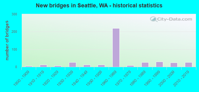
- New bridges - historical statistics
- 61900-1909
- 121910-1919
- 71920-1929
- 261930-1939
- 121940-1949
- 131950-1959
- 2191960-1969
- 91970-1979
- 271980-1989
- 291990-1999
- 252000-2009
- 272010-2019
- 12020-2022
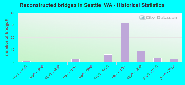
- Reconstructed bridges - Historical Statistics
- 11920-1929
- 01930-1939
- 01940-1949
- 21950-1959
- 01960-1969
- 61970-1979
- 321980-1989
- 91990-1999
- 32000-2009
- 22010-2019
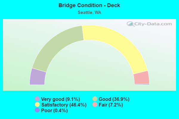
- Bridge Condition - Deck
- 9.1%Very good
- 36.9%Good
- 46.4%Satisfactory
- 7.2%Fair
- 0.4%Poor
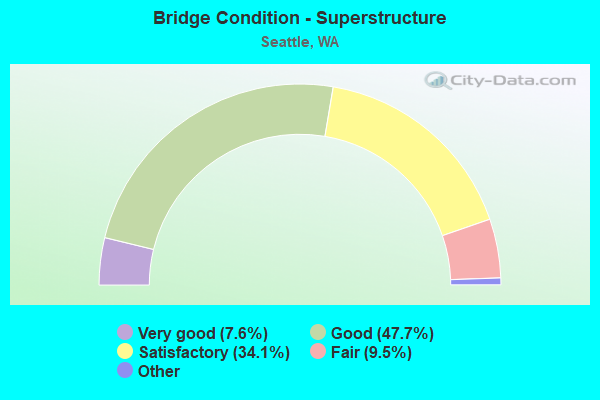
- Bridge Condition - Superstructure
- 7.6%Very good
- 47.7%Good
- 34.1%Satisfactory
- 9.5%Fair
- 1.1%Poor
- 0.4%Critical
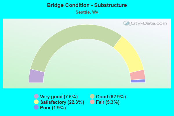
- Bridge Condition - Substructure
- 7.6%Very good
- 62.9%Good
- 22.3%Satisfactory
- 5.3%Fair
- 1.9%Poor
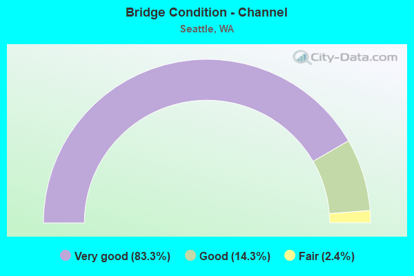
- Bridge Condition - Channel
- 83.3%Very good
- 14.3%Good
- 2.4%Fair
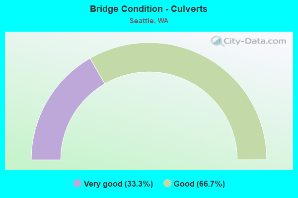
- Bridge Condition - Culverts
- 33.3%Very good
- 66.7%Good
Find on map >> Show street view
Structure Number: 88259, Location: SOUTHBOUND MP 1.68 (Lat: 47.576111, Lng: -122.297500), Route carried "under" structure: City street 1567, Year Built: 2008, Structure Length: 0. m, Average Daily Traffic: 3,800 (year 2018), Truck Traffic: 5%, Features Intersected: MLK WAY SOUTH, Facility Carried by Structure: CENTRAL LINK
Minimum Vertical Clearance: 6.88m (22.57ft), Kilometerpoint: 2.237, Lanes under structure: 5, Material/Design: Concrete continuous, Design/Construction: Box Beam or Girders - Single/Spread, Length of Maximum Span: 53.3m (174.9ft)
Find on map >> Show street view
Structure Number: 8826, Location: 9th Ave, Jefferson/Alder (Lat: 47.603333, Lng: -122.287500), Route carried "under" structure: City street 1140, Year Built: 2007, Structure Length: 0. m, Average Daily Traffic: 1,300 (year 2016), Truck Traffic: 5%, Features Intersected: 9th Ave, Facility Carried by Structure: None
Minimum Vertical Clearance: 5.49m (18.01ft), Kilometerpoint: 0.001, Lanes under structure: 2, Material/Design: Steel, Design/Construction: Girder and Floorbeam System, Length of Maximum Span: 22.9m (75.1ft)
Find on map >> Show street view
Structure Number: 883, Location: .1 MI E OF I-5 (Lat: 47.497447, Lng: -122.286617), Route carried "under" structure: City street 1140, Year Built: 2008, Structure Length: 0. m, Average Daily Traffic: 31,700 (year 2014), Truck Traffic: 5%, Features Intersected: MLK (S), Facility Carried by Structure: CENTRAL LINK
Minimum Vertical Clearance: 6.35m (20.83ft), Kilometerpoint: 9.978, Lanes under structure: 4, Material/Design: Prestressed concrete, Design/Construction: Box Beam or Girders - Single/Spread, Length of Maximum Span: 35.4m (116.1ft)
Find on map >> Show street view
Structure Number: 88302, Location: S/O 8th Ave & Pike St (Lat: 47.611819, Lng: -122.330936), Route carried "under" structure: City street 1140, Year Built: 2002, Structure Length: 0. m, Average Daily Traffic: 12,000 (year 2017), Truck Traffic: 5%, Features Intersected: PIKE ST, Facility Carried by Structure: PEDESTRIAN
Minimum Vertical Clearance: 19.81m (64.99ft), Kilometerpoint: 0.001, Lanes under structure: 2, Material/Design: Steel, Design/Construction: Truss - Deck, Length of Maximum Span: 25.9m (85.0ft)
Find on map >> Show street view
Structure Number: 8842, Location: King Cty Admn- Courthouse (Lat: 47.602881, Lng: -122.329761), Route carried "under" structure: City street 1140, Year Built: 1984, Structure Length: 0. m, Average Daily Traffic: 16,590 (year 2018), Truck Traffic: 5%, Features Intersected: 4th Ave, Facility Carried by Structure: King county ped br
Minimum Vertical Clearance: 24.38m (79.99ft), Kilometerpoint: 243.172, Lanes under structure: 4, Material/Design: Steel, Design/Construction: Girder and Floorbeam System, Length of Maximum Span: 22.9m (75.1ft)
Find on map >> Show street view
Structure Number: 88426, Location: 0.9 N JCT SR 520 (Lat: 47.658042, Lng: -122.301508), Route carried "under" structure: State highway 513, Year Built: 1958, Structure Length: 0. m, Average Daily Traffic: 43,546 (year 2019), Truck Traffic: 3%, Features Intersected: MONTLAKE BLVD (SR513), Facility Carried by Structure: PEDESTRIAN
Minimum Vertical Clearance: 5.21m (17.09ft), Kilometerpoint: 1.577, Lanes under structure: 5, Material/Design: Prestressed concrete, Design/Construction: Frame, Length of Maximum Span: 23.8m (78.1ft)
Find on map >> Show street view
Structure Number: 88427, Location: 0.8 N JCT SR 520 (Lat: 47.656144, Lng: -122.302039), Route carried "under" structure: State highway 513, Year Built: 1958, Structure Length: 0. m, Average Daily Traffic: 43,546 (year 2019), Truck Traffic: 3%, Features Intersected: MONTLAKE BLVD (SR513), Facility Carried by Structure: PEDESTRIAN
Minimum Vertical Clearance: 5.13m (16.83ft), Kilometerpoint: 1.352, Lanes under structure: 5, Material/Design: Prestressed concrete, Design/Construction: Tee Beam, Length of Maximum Span: 23.8m (78.1ft)
Find on map >> Show street view
Structure Number: 88862, Location: W Thomas St / Western Ave (Lat: 47.620711, Lng: -122.361050), Route carried "under" structure: Business City street 1140, Year Built: 2012, Structure Length: 0. m, Average Daily Traffic: 45,001 (year 2019), Truck Traffic: 5%, Features Intersected: Western Ave W, Facility Carried by Structure: Ped
Minimum Vertical Clearance: 6.12m (20.08ft), Kilometerpoint: 370.165, Lanes under structure: 6, Material/Design: Concrete, Design/Construction: Slab, Length of Maximum Span: 30.5m (100.1ft)
Find on map >> Show street view
Structure Number: 89044, Location: 1100 Eastlake Ave E (Lat: 47.628889, Lng: -122.329194), Route carried "under" structure: City street 1140, Year Built: 2014, Structure Length: 0. m, Average Daily Traffic: 6,558 (year 2016), Truck Traffic: 10%, Features Intersected: EASTLAKE, Facility Carried by Structure: PEDESTRIANS
Minimum Vertical Clearance: 7.62m (25.00ft), Kilometerpoint: 48.280, Lanes under structure: 2, Material/Design: Steel, Design/Construction: Box Beam or Girders - Multiple, Length of Maximum Span: 24.4m (80.1ft)
Find on map >> Show street view
Structure Number: 89128, Location: WESTLAKE MALL (Lat: 47.611836, Lng: -122.336850), Route carried "under" structure: City street 1140, Year Built: 1961, Structure Length: 0. m, Average Daily Traffic: 17,700 (year 2018), Truck Traffic: 5%, Features Intersected: SEATTLE CITY STREETS, Facility Carried by Structure: MONORAIL
Minimum Vertical Clearance: 6.10m (20.01ft), Kilometerpoint: 0.001, Lanes under structure: 4, Material/Design: Prestressed concrete, Design/Construction: Stringer/Multi-beam, Length of Maximum Span: 9.4m (30.8ft)