Bridge Statistics for Seattle, Washington (WA)
Condition, Traffic, Stress, Structural Evaluation, Project Costs
- National Bridge Inventory (NBI) Statistics
- 413Number of bridges
- 21,407ft / 6,525mTotal length
- $5,414,432,000Total costs
- 16,995,808Total average daily traffic
- 1,082,900Total average daily truck traffic
- National Bridge Inventory (NBI) Registered Bridges for Seattle
- No street view available for this location
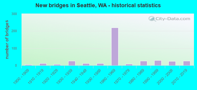
- New bridges - historical statistics
- 61900-1909
- 121910-1919
- 71920-1929
- 261930-1939
- 121940-1949
- 131950-1959
- 2191960-1969
- 91970-1979
- 271980-1989
- 291990-1999
- 252000-2009
- 272010-2019
- 12020-2022
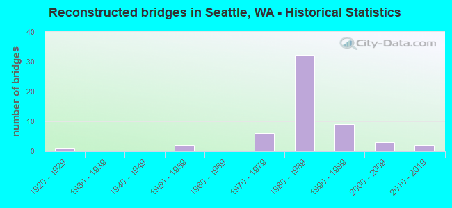
- Reconstructed bridges - Historical Statistics
- 11920-1929
- 01930-1939
- 01940-1949
- 21950-1959
- 01960-1969
- 61970-1979
- 321980-1989
- 91990-1999
- 32000-2009
- 22010-2019
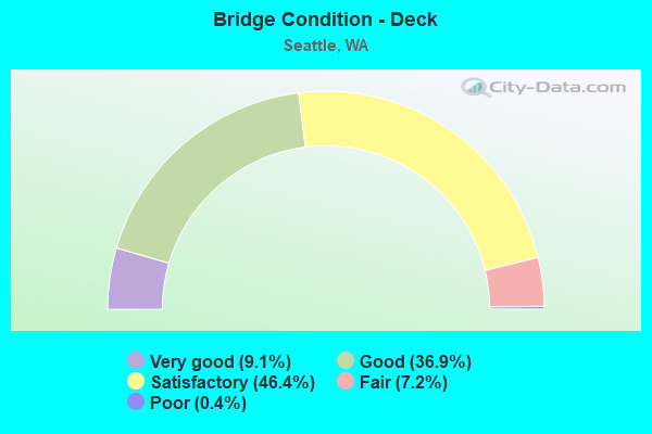
- Bridge Condition - Deck
- 9.1%Very good
- 36.9%Good
- 46.4%Satisfactory
- 7.2%Fair
- 0.4%Poor
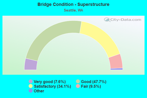
- Bridge Condition - Superstructure
- 7.6%Very good
- 47.7%Good
- 34.1%Satisfactory
- 9.5%Fair
- 1.1%Poor
- 0.4%Critical
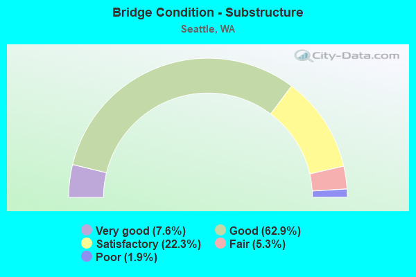
- Bridge Condition - Substructure
- 7.6%Very good
- 62.9%Good
- 22.3%Satisfactory
- 5.3%Fair
- 1.9%Poor
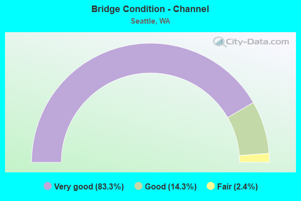
- Bridge Condition - Channel
- 83.3%Very good
- 14.3%Good
- 2.4%Fair
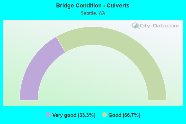
- Bridge Condition - Culverts
- 33.3%Very good
- 66.7%Good
Find on map >> Show street view
Structure Number: 85223, Location: W FORT ST & GILMAN AVE W (Lat: 47.661056, Lng: -122.392278), Route carried "on" structure: City street 1140, Year Built: 1985, Status: Open, Structure Length: 3.96m (12.99ft), Average Daily Traffic: 1,500 (year 2018), Truck Traffic: 5%, Average Future Daily Traffic: 1,830 (year 2038), Design Load: HS 20, Features Intersected: RAILROAD, Facility Carried by Structure: W FORT ST
Minimum Vertical Clearance: 30+ m (98+ ft), Kilometerpoint: 0.001, Lanes on structure: 2, Owner: City or Municipal Highway Agency, Approaching Roadway Width: 8.5m (27.9ft), Material/Design: Prestressed concrete, Design/Construction: Stringer/Multi-beam, Number Of Spans In Main Unit: 1, Length of Maximum Span: 38.1m (125.0ft), Curb or Sidewalk Widths: Left: 2.4m (7.9ft), Right: 0.0m, Curb-To-Curb Width: 8.5m (27.9ft), Out-to-Out Width: 11.6m (38.1ft)
Condition: Deck: Good, Superstructure: Good, Substructure: Good, Operating Rating: 89.8 metric tons, Method Used To Determine Operating Rating: Load Factor (LF), Inventory Rating: 20.9 metric tons, Method Used To Determine Inventory Rating: Load Factor (LF), Structural Evaluation: Somewhat better than minimum adequacy, Deck Geometry: Somewhat better than minimum adequacy, Underclear: Meets minimum limits, Approach Roadway Alignment: Equal to present desirable criteria, Length Of Structure Improvement: 4.27m (14.01ft), Designated Inspection Frequency: Every 24 months, Inspection Date: June 2021, Bridge Improvement Cost: $2,128,000, Roadway Improvement Cost: $426,000, Total Project Cost: $4,256,000 ( Estimate for 2014), Deck Structure Type: Concrete Cast-file-Place, Wearing Surface/Protective System: Wearing Surface: Monolithic Concrete, Deck Protection: Epoxy Coated Reinforcing
Find on map >> Show street view
Structure Number: 85242, Location: 3200 W Howe St (Lat: 47.635900, Lng: -122.398900), Route carried "on" structure: City street 1140, Year Built: 1946, Status: Open, Structure Length: 8.53m (27.99ft), Average Daily Traffic: 3,400 (year 2017), Truck Traffic: 5%, Average Future Daily Traffic: 6,000 (year 2038), Design Load: HS 20, Features Intersected: 32ND AVE W, RAVINE, Facility Carried by Structure: W HOWE ST
Minimum Vertical Clearance: 30+ m (98+ ft), Kilometerpoint: 0.001, Lanes on structure: 2, Lanes under structure: 2, Owner: City or Municipal Highway Agency, Approaching Roadway Width: 8.5m (27.9ft), Material/Design: Steel, Design/Construction: Stringer/Multi-beam, Number Of Spans In Main Unit: 4, Length of Maximum Span: 21.3m (69.9ft), Curb or Sidewalk Widths: Left: 0.0m, Right: 1.4m (4.6ft), Curb-To-Curb Width: 8.1m (26.6ft), Out-to-Out Width: 10.1m (33.1ft)
Condition: Deck: Good, Superstructure: Satisfactory, Substructure: Good, Operating Rating: 45.4 metric tons, Method Used To Determine Operating Rating: Load Factor (LF), Inventory Rating: 27.2 metric tons, Method Used To Determine Inventory Rating: Load Factor (LF), Structural Evaluation: Equal to present minimum criteria, Deck Geometry: High priority of corrective action, Underclear: Equal to present minimum criteria, Approach Roadway Alignment: Equal to present minimum criteria, Length Of Structure Improvement: 8.84m (29.00ft), Designated Inspection Frequency: Every 24 months, Critical Feature Inspection Frequency: Every 24 months, Inspection Date: July 2020, Critical Feature Inspection Date: July 2020, Bridge Improvement Cost: $4,408,000, Roadway Improvement Cost: $882,000, Total Project Cost: $8,816,000 ( Estimate for 2014), Deck Structure Type: Concrete Cast-file-Place, Wearing Surface/Protective System: Wearing Surface: Bituminous
Find on map >> Show street view
Structure Number: 85262, Location: S Spokane St & E Marginal (Lat: 47.571389, Lng: -122.332222), Route carried "on" structure: City street 1140, Year Built: 1941, Year Reconstructed: 2012, Status: Open, Structure Length: 103.94m (341.01ft), Average Daily Traffic: 42,350 (year 2021), Truck Traffic: 10%, Average Future Daily Traffic: 51,700 (year 2042), Design Load: HS 20, Features Intersected: E MARGINAL WY, 1ST, 4TH, Facility Carried by Structure: S SPOKANE ST
Minimum Vertical Clearance: 4.57m (14.99ft), Kilometerpoint: 144.841, Lanes on structure: 6, Lanes under structure: 12, Base Highway Network: Yes (Inventory Route: 70148200, Subroute: 80), Owner: City or Municipal Highway Agency, Approaching Roadway Width: 20.4m (66.9ft), Skew: 30 degrees, Material/Design: Concrete, Design/Construction: Stringer/Multi-beam, Number Of Spans In Main Unit: 53, Number Of Approach Spans: 16, Length of Maximum Span: 22.9m (75.1ft), Curb-To-Curb Width: 26.2m (86.0ft), Out-to-Out Width: 26.8m (87.9ft)
Condition: Deck: Good, Superstructure: Satisfactory, Substructure: Good, Operating Rating: 32.7 metric tons, Method Used To Determine Operating Rating: Load Factor (LF), Inventory Rating: 19.0 metric tons, Method Used To Determine Inventory Rating: Load Factor (LF), Structural Evaluation: Meets minimum limits, Deck Geometry: Meets minimum limits, Underclear: Equal to present minimum criteria, Approach Roadway Alignment: Equal to present minimum criteria, Length Of Structure Improvement: 103.94m (341.01ft), Designated Inspection Frequency: Every 24 months, Critical Feature Inspection Frequency: Every 24 months, Inspection Date: April 2021, Critical Feature Inspection Date: April 2021, Bridge Improvement Cost: $47,058,000, Roadway Improvement Cost: $9,412,000, Total Project Cost: $94,116,000 ( Estimate for 2014), Deck Structure Type: Concrete Cast-file-Place, Wearing Surface/Protective System: Wearing Surface: Integral Concrete
Find on map >> Show street view
Structure Number: 85273, Location: 4700 4th Ave S (Lat: 47.560278, Lng: -122.329444), Route carried "on" structure: City street 1140, Year Built: 1933, Year Reconstructed: 1985, Status: Open, Structure Length: 53.07m (174.11ft), Average Daily Traffic: 28,000 (year 2018), Truck Traffic: 10%, Average Future Daily Traffic: 32,000 (year 2038), Design Load: H 20, Features Intersected: ARGO RR YARD, Facility Carried by Structure: 4TH AVE S
Minimum Vertical Clearance: 30+ m (98+ ft), Kilometerpoint: 149.669, Lanes on structure: 4, Base Highway Network: Yes, Owner: City or Municipal Highway Agency, Approaching Roadway Width: 13.4m (44.0ft), Skew: 9 degrees, Material/Design: Steel, Design/Construction: Girder and Floorbeam System, Number Of Spans In Main Unit: 12, Number Of Approach Spans: 13, Length of Maximum Span: 29.3m (96.1ft), Curb or Sidewalk Widths: Left: 1.5m (4.9ft), Right: 0.0m, Curb-To-Curb Width: 13.4m (44.0ft), Out-to-Out Width: 15.8m (51.8ft)
Condition: Deck: Fair, Superstructure: Fair, Substructure: Poor, Operating Rating: 36.3 metric tons, Method Used To Determine Operating Rating: Load Factor (LF), Inventory Rating: 21.8 metric tons, Method Used To Determine Inventory Rating: Load Factor (LF), Structural Evaluation: Meets minimum limits, Deck Geometry: High priority of replacement, Underclear: High priority of replacement, Approach Roadway Alignment: Equal to present desirable criteria, Length Of Structure Improvement: 53.37m (175.10ft), Designated Inspection Frequency: Every 24 months, Inspection Date: July 2021, Bridge Improvement Cost: $43,425,000, Roadway Improvement Cost: $8,685,000, Total Project Cost: $86,850,000 ( Estimate for 2014), Deck Structure Type: Concrete Cast-file-Place, Wearing Surface/Protective System: Wearing Surface: Latex Concrete
Find on map >> Show street view
Structure Number: 85274, Location: 4500 1st Ave S (Lat: 47.563611, Lng: -122.334167), Route carried "on" structure: City street 1140, Year Built: 1935, Year Reconstructed: 1989, Status: Open, Structure Length: 77.54m (254.40ft), Average Daily Traffic: 19,000 (year 2019), Truck Traffic: 10%, Average Future Daily Traffic: 22,000 (year 2039), Design Load: HS 20, Features Intersected: ARGO RR YARD, Facility Carried by Structure: 1ST AVE S
Minimum Vertical Clearance: 30+ m (98+ ft), Kilometerpoint: 62.764, Lanes on structure: 4, Lanes under structure: 2, Base Highway Network: Yes, Owner: City or Municipal Highway Agency, Approaching Roadway Width: 15.2m (49.9ft), Skew: 4 degrees, Material/Design: Steel continuous, Design/Construction: Stringer/Multi-beam, Number Of Spans In Main Unit: 14, Number Of Approach Spans: 17, Length of Maximum Span: 30.8m (101.0ft), Curb or Sidewalk Widths: Left: 2.4m (7.9ft), Right: 2.4m (7.9ft), Curb-To-Curb Width: 15.2m (49.9ft), Out-to-Out Width: 20.7m (67.9ft)
Condition: Deck: Good, Superstructure: Fair, Substructure: Satisfactory, Operating Rating: 51.7 metric tons, Method Used To Determine Operating Rating: Load Testing, Inventory Rating: 30.8 metric tons, Method Used To Determine Inventory Rating: Load Testing, Structural Evaluation: Somewhat better than minimum adequacy, Deck Geometry: High priority of corrective action, Underclear: High priority of corrective action, Approach Roadway Alignment: Equal to present desirable criteria, Length Of Structure Improvement: 77.54m (254.40ft), Designated Inspection Frequency: Every 24 months, Critical Feature Inspection Frequency: Every 24 months, Inspection Date: July 2021, Critical Feature Inspection Date: July 2021, Bridge Improvement Cost: $26,458,000, Roadway Improvement Cost: $5,292,000, Total Project Cost: $52,915,000 ( Estimate for 2014), Deck Structure Type: Concrete Cast-file-Place, Wearing Surface/Protective System: Wearing Surface: Monolithic Concrete, Deck Protection: Epoxy Coated Reinforcing
Find on map >> Show street view
Structure Number: 85275, Location: 4100 Roosevelt Way NE (Lat: 47.656111, Lng: -122.317778), Route carried "on" structure: City street 1140, Year Built: 1949, Status: Open, Structure Length: 2.10m (6.89ft), Average Daily Traffic: 24,500 (year 2018), Truck Traffic: 5%, Average Future Daily Traffic: 33,300 (year 2040), Features Intersected: NE CAMPUS PARKWAY, Facility Carried by Structure: ROOSEVELT WAY NE
Minimum Vertical Clearance: 30+ m (98+ ft), Kilometerpoint: 194.731, Lanes on structure: 4, Lanes under structure: 2, Base Highway Network: Yes, Owner: City or Municipal Highway Agency, Approaching Roadway Width: 24.1m (79.1ft), Skew: 22 degrees, Material/Design: Concrete continuous, Design/Construction: Slab, Number Of Spans In Main Unit: 1, Length of Maximum Span: 21.0m (68.9ft), Curb or Sidewalk Widths: Left: 2.2m (7.2ft), Right: 2.2m (7.2ft), Curb-To-Curb Width: 24.2m (79.4ft), Out-to-Out Width: 29.0m (95.1ft)
Condition: Deck: Satisfactory, Superstructure: Satisfactory, Substructure: Good, Operating Rating: 72.6 metric tons, Method Used To Determine Operating Rating: Load Factor (LF), Inventory Rating: 43.5 metric tons, Method Used To Determine Inventory Rating: Load Factor (LF), Structural Evaluation: Equal to present minimum criteria, Deck Geometry: Superior to present desirable criteria, Underclear: Superior to present desirable criteria, Approach Roadway Alignment: Equal to present desirable criteria, Length Of Structure Improvement: 2.41m (7.91ft), Designated Inspection Frequency: Every 24 months, Inspection Date: July 2021, Bridge Improvement Cost: $1,959,000, Roadway Improvement Cost: $392,000, Total Project Cost: $3,918,000 ( Estimate for 2014), Deck Structure Type: Concrete Cast-file-Place, Wearing Surface/Protective System: Wearing Surface: Bituminous
Find on map >> Show street view
Structure Number: 85276, Location: 3800 Eastlake Ave (Lat: 47.654733, Lng: -122.318856), Route carried "on" structure: City street 1140, Year Built: 1930, Status: Open, Structure Length: 9.78m (32.09ft), Average Daily Traffic: 35,000 (year 2020), Truck Traffic: 5%, Average Future Daily Traffic: 45,000 (year 2040), Design Load: HS 20, Features Intersected: NE PACIFIC ST, Facility Carried by Structure: EASTLAKE AVE NE
Minimum Vertical Clearance: 30+ m (98+ ft), Kilometerpoint: 5.150, Lanes on structure: 4, Lanes under structure: 2, Base Highway Network: Yes, Owner: City or Municipal Highway Agency, Approaching Roadway Width: 17.7m (58.1ft), Skew: 2 degrees, Material/Design: Concrete continuous, Design/Construction: Tee Beam, Number Of Spans In Main Unit: 9, Length of Maximum Span: 15.5m (50.9ft), Curb or Sidewalk Widths: Left: 1.8m (5.9ft), Right: 1.8m (5.9ft), Curb-To-Curb Width: 17.7m (58.1ft), Out-to-Out Width: 22.9m (75.1ft)
Condition: Deck: Fair, Superstructure: Fair, Substructure: Satisfactory, Operating Rating: 42.6 metric tons, Method Used To Determine Operating Rating: Load Testing, Inventory Rating: 25.4 metric tons, Method Used To Determine Inventory Rating: Load Testing, Structural Evaluation: Somewhat better than minimum adequacy, Deck Geometry: Somewhat better than minimum adequacy, Underclear: High priority of replacement, Approach Roadway Alignment: Equal to present minimum criteria, Length Of Structure Improvement: 10.09m (33.10ft), Designated Inspection Frequency: Every 24 months, Inspection Date: May 2020, Bridge Improvement Cost: $8,209,000, Roadway Improvement Cost: $1,642,000, Total Project Cost: $16,418,000 ( Estimate for 2014), Deck Structure Type: Concrete Cast-file-Place, Wearing Surface/Protective System: Wearing Surface: Bituminous
Find on map >> Show street view
Structure Number: 85277, Location: 3800 Eastlake Ave (Lat: 47.652778, Lng: -122.320278), Route carried "on" structure: City street 1140, Year Built: 1930, Status: Open, Structure Length: 19.63m (64.40ft), Average Daily Traffic: 36,000 (year 2019), Truck Traffic: 5%, Average Future Daily Traffic: 45,000 (year 2039), Design Load: H 20, Features Intersected: NE 40TH ST, BURKE GILMAN, Facility Carried by Structure: EASTLAKE AVE NE
Minimum Vertical Clearance: 5.49m (18.01ft), Kilometerpoint: 5.311, Lanes on structure: 4, Lanes under structure: 2, Base Highway Network: Yes, Owner: City or Municipal Highway Agency, Approaching Roadway Width: 17.7m (58.1ft), Skew: 2 degrees, Material/Design: Steel continuous, Design/Construction: Truss - Deck, Number Of Spans In Main Unit: 7, Length of Maximum Span: 40.5m (132.9ft), Curb or Sidewalk Widths: Left: 1.8m (5.9ft), Right: 1.8m (5.9ft), Curb-To-Curb Width: 17.7m (58.1ft), Out-to-Out Width: 22.9m (75.1ft)
Condition: Deck: Satisfactory, Superstructure: Satisfactory, Substructure: Poor, Channel: Very good, Operating Rating: 52.6 metric tons, Method Used To Determine Operating Rating: Load Factor (LF), Inventory Rating: 31.7 metric tons, Method Used To Determine Inventory Rating: Load Factor (LF), Structural Evaluation: Meets minimum limits, Deck Geometry: Somewhat better than minimum adequacy, Underclear: High priority of replacement, Waterway Adequacy: Equal to present desirable criteria, Approach Roadway Alignment: Equal to present desirable criteria, Length Of Structure Improvement: 19.93m (65.39ft), Designated Inspection Frequency: Every 24 months, Critical Feature Inspection Frequency: Every 24 months, Underwater Inspection Frequency: Every 24 months, Inspection Date: July 2021, Critical Feature Inspection Date: August 2020, Underwater Inspection Date: November 2020, Bridge Improvement Cost: $16,219,000, Roadway Improvement Cost: $3,244,000, Total Project Cost: $32,438,000 ( Estimate for 2014), Deck Structure Type: Concrete Cast-file-Place, Wearing Surface/Protective System: Wearing Surface: Bituminous
Find on map >> Show street view
Structure Number: 85278, Location: 3200 EASTLAKE AVE (Lat: 47.652778, Lng: -122.320278), Route carried "on" structure: City street 1140, Year Built: 1915, Year Reconstructed: 1933, Status: Open, Structure Length: 8.87m (29.10ft), Average Daily Traffic: 35,000 (year 2019), Truck Traffic: 5%, Average Future Daily Traffic: 45,000 (year 2039), Design Load: H 20, Features Intersected: PORTAGE BAY, Facility Carried by Structure: EASTLAKE AVE NE
Minimum Vertical Clearance: 5.03m (16.50ft), Kilometerpoint: 0.001, Lanes on structure: 4, Base Highway Network: Yes, Owner: City or Municipal Highway Agency, Approaching Roadway Width: 17.7m (58.1ft), Navigation Control: Yes ( Vertical Clearance: 13.4m (44.0ft), Horizontal Clearance: 53.3m (174.9ft)), Material/Design: Steel, Design/Construction: Movable - Bascule, Number Of Spans In Main Unit: 1, Length of Maximum Span: 66.4m (217.8ft), Curb or Sidewalk Widths: Left: 1.2m (3.9ft), Right: 1.2m (3.9ft), Curb-To-Curb Width: 12.1m (39.7ft), Out-to-Out Width: 23.1m (75.8ft)
Condition: Deck: Good, Superstructure: Poor, Substructure: Fair, Channel: Good, Operating Rating: 44.4 metric tons, Method Used To Determine Operating Rating: Load Factor (LF), Inventory Rating: 26.3 metric tons, Method Used To Determine Inventory Rating: Load Factor (LF), Structural Evaluation: Meets minimum limits, Deck Geometry: High priority of replacement, Waterway Adequacy: Equal to present desirable criteria, Approach Roadway Alignment: Equal to present desirable criteria, Length Of Structure Improvement: 8.87m (29.10ft), Designated Inspection Frequency: Every 24 months, Critical Feature Inspection Frequency: Every 24 months, Underwater Inspection Frequency: Every 60 months, Other Special Inspection Frequency: Every 24 months, Inspection Date: August 2021, Critical Feature Inspection Date: March 2021, Underwater Inspection Date: April 2018, Other Special Inspection Date: August 2021, Bridge Improvement Cost: $3,492,000, Roadway Improvement Cost: $50,000, Total Project Cost: $25,000,000 ( Estimate for 2020), Deck Structure Type: Open Grating
Find on map >> Show street view
Structure Number: 85279, Location: 3200 Eastlake Ave (Lat: 47.652222, Lng: -122.320833), Route carried "on" structure: City street 1140, Year Built: 1930, Status: Open, Structure Length: 6.13m (20.11ft), Average Daily Traffic: 36,000 (year 2019), Truck Traffic: 5%, Average Future Daily Traffic: 45,000 (year 2039), Design Load: H 20, Features Intersected: PORTAGE BAY PL E, Facility Carried by Structure: EASTLAKE AVE NE
Minimum Vertical Clearance: 30+ m (98+ ft), Kilometerpoint: 5.472, Lanes on structure: 4, Lanes under structure: 1, Base Highway Network: Yes, Owner: City or Municipal Highway Agency, Approaching Roadway Width: 17.7m (58.1ft), Material/Design: Steel continuous, Design/Construction: Truss - Deck, Number Of Spans In Main Unit: 3, Length of Maximum Span: 30.5m (100.1ft), Curb or Sidewalk Widths: Left: 1.8m (5.9ft), Right: 1.8m (5.9ft), Curb-To-Curb Width: 17.7m (58.1ft), Out-to-Out Width: 22.9m (75.1ft)
Condition: Deck: Satisfactory, Superstructure: Fair, Substructure: Fair, Channel: Very good, Operating Rating: 52.6 metric tons, Method Used To Determine Operating Rating: Load Factor (LF), Inventory Rating: 31.7 metric tons, Method Used To Determine Inventory Rating: Load Factor (LF), Structural Evaluation: Somewhat better than minimum adequacy, Deck Geometry: Somewhat better than minimum adequacy, Underclear: High priority of corrective action, Waterway Adequacy: Equal to present desirable criteria, Approach Roadway Alignment: Equal to present desirable criteria, Length Of Structure Improvement: 6.13m (20.11ft), Designated Inspection Frequency: Every 24 months, Critical Feature Inspection Frequency: Every 24 months, Underwater Inspection Frequency: Every 60 months, Inspection Date: July 2021, Critical Feature Inspection Date: August 2020, Underwater Inspection Date: April 2018, Bridge Improvement Cost: $2,412,000, Roadway Improvement Cost: $482,000, Total Project Cost: $4,824,000 ( Estimate for 2014), Deck Structure Type: Concrete Cast-file-Place, Wearing Surface/Protective System: Wearing Surface: Bituminous
Find on map >> Show street view
Structure Number: 85283, Location: 3000 FREMONT AVE N (Lat: 47.647500, Lng: -122.349722), Route carried "on" structure: City street 1140, Year Built: 1917, Status: Open, Structure Length: 9.66m (31.69ft), Average Daily Traffic: 29,300 (year 2018), Truck Traffic: 10%, Average Future Daily Traffic: 42,800 (year 2040), Design Load: HS 25 or greater, Features Intersected: SHIP CANAL, Facility Carried by Structure: FREMONT AVE N
Minimum Vertical Clearance: 4.93m (16.17ft), Kilometerpoint: 19.634, Lanes on structure: 4, Base Highway Network: Yes, Owner: City or Municipal Highway Agency, Approaching Roadway Width: 16.5m (54.1ft), Navigation Control: Yes ( Vertical Clearance: 9.1m (29.9ft), Horizontal Clearance: 45.7m (149.9ft)), Material/Design: Steel, Design/Construction: Movable - Bascule, Number Of Spans In Main Unit: 1, Length of Maximum Span: 73.8m (242.1ft), Curb or Sidewalk Widths: Left: 3.1m (10.2ft), Right: 3.1m (10.2ft), Curb-To-Curb Width: 11.9m (39.0ft), Out-to-Out Width: 13.2m (43.3ft)
Condition: Deck: Good, Superstructure: Satisfactory, Substructure: Satisfactory, Channel: Very good, Operating Rating: 49.9 metric tons, Method Used To Determine Operating Rating: Load Factor (LF), Inventory Rating: 29.9 metric tons, Method Used To Determine Inventory Rating: Load Factor (LF), Structural Evaluation: Equal to present minimum criteria, Deck Geometry: High priority of replacement, Waterway Adequacy: Equal to present desirable criteria, Approach Roadway Alignment: Equal to present desirable criteria, Length Of Structure Improvement: 9.66m (31.69ft), Designated Inspection Frequency: Every 24 months, Critical Feature Inspection Frequency: Every 24 months, Underwater Inspection Frequency: Every 60 months, Other Special Inspection Frequency: Every 24 months, Inspection Date: September 2020, Critical Feature Inspection Date: September 2020, Underwater Inspection Date: November 2019, Other Special Inspection Date: October 2020, Bridge Improvement Cost: $3,550,000, Roadway Improvement Cost: $710,000, Total Project Cost: $7,101,000 ( Estimate for 2014), Deck Structure Type: Open Grating
Find on map >> Show street view
Structure Number: 85297, Location: 1200 SW Spokane St (Lat: 47.571539, Lng: -122.344728), Route carried "on" structure: City street 1140, Year Built: 1983, Status: Open, Structure Length: 105.00m (344.49ft), Average Daily Traffic: 10,000 (year 2020), Truck Traffic: 5%, Average Future Daily Traffic: 65,000 (year 2042), Design Load: HS 20, Features Intersected: E MARGINAL WAY S, Facility Carried by Structure: SW SPOKANE ST
Minimum Vertical Clearance: 5.23m (17.16ft), Kilometerpoint: 0.161, Lanes on structure: 1, Lanes under structure: 2, Base Highway Network: Yes, Owner: City or Municipal Highway Agency, Approaching Roadway Width: 7.9m (25.9ft), Skew: 9 degrees, Material/Design: Prestressed concrete continuous, Design/Construction: Stringer/Multi-beam, Number Of Spans In Main Unit: 31, Length of Maximum Span: 39.6m (129.9ft), Curb-To-Curb Width: 7.9m (25.9ft), Out-to-Out Width: 9.1m (29.9ft)
Condition: Deck: Satisfactory, Superstructure: Satisfactory, Substructure: Good, Operating Rating: 43.1 metric tons, Method Used To Determine Operating Rating: Load Factor (LF) rating reported by rating factor (RF) method using MS18 loading, Inventory Rating: 25.9 metric tons, Method Used To Determine Inventory Rating: Load Factor (LF) rating reported by rating factor (RF) method using MS18 loading, Structural Evaluation: Equal to present minimum criteria, Deck Geometry: High priority of corrective action, Underclear: High priority of replacement, Approach Roadway Alignment: Equal to present desirable criteria, Length Of Structure Improvement: 105.31m (345.51ft), Designated Inspection Frequency: Every 24 months, Inspection Date: March 2021, Bridge Improvement Cost: $35,932,000, Roadway Improvement Cost: $7,186,000, Total Project Cost: $71,864,000 ( Estimate for 2014), Deck Structure Type: Concrete Cast-file-Place, Wearing Surface/Protective System: Wearing Surface: Monolithic Concrete
Find on map >> Show street view
Structure Number: 85298, Location: 800 SW Spokane St (Lat: 47.571506, Lng: -122.346269), Route carried "on" structure: City street 1140, Year Built: 1975, Status: Open, Structure Length: 14.78m (48.49ft), Average Daily Traffic: 8,800 (year 2018), Truck Traffic: 35%, Average Future Daily Traffic: 13,000 (year 2040), Design Load: HS 20, Features Intersected: DUWAMISH RIVER E WATERWY, Facility Carried by Structure: SW SPOKANE ST
Minimum Vertical Clearance: 30+ m (98+ ft), Kilometerpoint: 109.435, Lanes on structure: 5, Base Highway Network: Yes (Inventory Route: 70148200, Subroute: 89), Owner: City or Municipal Highway Agency, Approaching Roadway Width: 17.4m (57.1ft), Skew: 1 degrees, Material/Design: Prestressed concrete, Design/Construction: Tee Beam, Number Of Spans In Main Unit: 6, Length of Maximum Span: 26.8m (87.9ft), Curb or Sidewalk Widths: Left: 0.0m, Right: 2.4m (7.9ft), Curb-To-Curb Width: 17.4m (57.1ft), Out-to-Out Width: 21.6m (70.9ft)
Condition: Deck: Very good, Superstructure: Satisfactory, Substructure: Good, Channel: Very good, Operating Rating: 65.3 metric tons, Method Used To Determine Operating Rating: Load Factor (LF), Inventory Rating: 39.0 metric tons, Method Used To Determine Inventory Rating: Load Factor (LF), Structural Evaluation: Equal to present minimum criteria, Deck Geometry: High priority of replacement, Waterway Adequacy: Equal to present minimum criteria, Approach Roadway Alignment: Equal to present desirable criteria, Length Of Structure Improvement: 14.78m (48.49ft), Designated Inspection Frequency: Every 24 months, Underwater Inspection Frequency: Every 60 months, Inspection Date: July 2021, Underwater Inspection Date: April 2021, Bridge Improvement Cost: $5,723,000, Roadway Improvement Cost: $1,145,000, Total Project Cost: $11,446,000 ( Estimate for 2014), Deck Structure Type: Concrete Cast-file-Place, Wearing Surface/Protective System: Wearing Surface: Monolithic Concrete, Deck Protection: Epoxy Coated Reinforcing
Find on map >> Show street view
Structure Number: 853, Location: 1200 SW Spokane St (Lat: 47.571111, Lng: -122.350000), Route carried "on" structure: Ramp City street 1140, Year Built: 1983, Status: Open, Structure Length: 46.36m (152.10ft), Average Daily Traffic: 93,180 (year 2016), Truck Traffic: 10%, Average Future Daily Traffic: 144,054 (year 2036), Design Load: HS 20, Features Intersected: DELRIDGE WAY SW, Facility Carried by Structure: SW SPOKANE ST
Minimum Vertical Clearance: 5.18m (16.99ft), Kilometerpoint: 210.985, Lanes on structure: 2, Lanes under structure: 4, Owner: City or Municipal Highway Agency, Approaching Roadway Width: 11.0m (36.1ft), Skew: 9 degrees, Material/Design: Prestressed concrete continuous, Design/Construction: Stringer/Multi-beam, Number Of Spans In Main Unit: 14, Number Of Approach Spans: 1, Length of Maximum Span: 45.1m (148.0ft), Curb-To-Curb Width: 11.0m (36.1ft), Out-to-Out Width: 12.2m (40.0ft)
Condition: Deck: Satisfactory, Superstructure: Good, Substructure: Good, Operating Rating: 49.9 metric tons, Method Used To Determine Operating Rating: Load Testing, Inventory Rating: 29.9 metric tons, Method Used To Determine Inventory Rating: Load Testing, Structural Evaluation: Better than present minimum criteria, Deck Geometry: Better than present minimum criteria, Underclear: High priority of corrective action, Approach Roadway Alignment: Equal to present desirable criteria, Length Of Structure Improvement: 46.36m (152.10ft), Designated Inspection Frequency: Every 24 months, Inspection Date: May 2021, Bridge Improvement Cost: $61,448,000, Roadway Improvement Cost: $15,362,000, Total Project Cost: $76,810,000 ( Estimate for 2041), Deck Structure Type: Concrete Cast-file-Place, Wearing Surface/Protective System: Wearing Surface: Monolithic Concrete
Find on map >> Show street view
Structure Number: 85301, Location: 1200 SW Spokane St (Lat: 47.571111, Lng: -122.350000), Route carried "on" structure: City street 1140, Year Built: 1983, Status: Open, Structure Length: 46.73m (153.31ft), Average Daily Traffic: 98,700 (year 2018), Truck Traffic: 10%, Average Future Daily Traffic: 145,000 (year 2041), Design Load: HS 20, Features Intersected: DELRIDGE WAY SW, Facility Carried by Structure: SW SPOKANE ST
Minimum Vertical Clearance: 30+ m (98+ ft), Kilometerpoint: 0.001, Lanes on structure: 6, Lanes under structure: 18, Base Highway Network: Yes (Inventory Route: 70148200, Subroute: 89), Owner: City or Municipal Highway Agency, Approaching Roadway Width: 26.2m (86.0ft), Skew: 39 degrees, Material/Design: Prestressed concrete continuous, Design/Construction: Stringer/Multi-beam, Number Of Spans In Main Unit: 11, Length of Maximum Span: 57.6m (189.0ft), Curb-To-Curb Width: 31.1m (102.0ft), Out-to-Out Width: 32.3m (106.0ft)
Condition: Deck: Satisfactory, Superstructure: Good, Substructure: Good, Operating Rating: 24.5 metric tons, Method Used To Determine Operating Rating: Load Factor (LF), Inventory Rating: 19.0 metric tons, Method Used To Determine Inventory Rating: Load Factor (LF), Structural Evaluation: Meets minimum limits, Deck Geometry: Superior to present desirable criteria, Underclear: Equal to present minimum criteria, Approach Roadway Alignment: Equal to present desirable criteria, Length Of Structure Improvement: 46.73m (153.31ft), Designated Inspection Frequency: Every 24 months, Inspection Date: May 2021, Bridge Improvement Cost: $64,999,000, Roadway Improvement Cost: $16,249,000, Total Project Cost: $81,249,000 ( Estimate for 2041), Deck Structure Type: Concrete Cast-file-Place, Wearing Surface/Protective System: Wearing Surface: Monolithic Concrete
Find on map >> Show street view
Structure Number: 85302, Location: 1200 SW Spokane St (Lat: 47.571111, Lng: -122.350000), Route carried "on" structure: City street 1140, Year Built: 1983, Status: Closed, Structure Length: 40.84m (133.99ft), Average Daily Traffic: 108,179 (year 2016), Truck Traffic: 8%, Average Future Daily Traffic: 170,000 (year 2040), Design Load: HS 20, Features Intersected: DUWAMISH RIVER W WATERWY, Facility Carried by Structure: SW SPOKANE ST
Minimum Vertical Clearance: 30+ m (98+ ft), Kilometerpoint: 0.001, Lanes on structure: 6, Base Highway Network: Yes (Inventory Route: 42000340, Subroute: 89), Owner: City or Municipal Highway Agency, Approaching Roadway Width: 32.3m (106.0ft), Skew: 39 degrees, Navigation Control: Yes ( Vertical Clearance: 42.7m (140.1ft), Horizontal Clearance: 38.1m (125.0ft)), Material/Design: Concrete continuous, Design/Construction: Box Beam or Girders - Multiple, Number Of Spans In Main Unit: 3, Length of Maximum Span: 179.8m (589.9ft), Curb-To-Curb Width: 30.5m (100.1ft), Out-to-Out Width: 32.3m (106.0ft)
Condition: Deck: Satisfactory, Superstructure: Critical, Substructure: Good, Channel: Very good, Deck Geometry: Superior to present desirable criteria, Waterway Adequacy: Equal to present desirable criteria, Approach Roadway Alignment: Equal to present desirable criteria, Bridge Posting: Required (Relationship of Operating Rating to Maximum Legal Load: > 39.9% below), Length Of Structure Improvement: 40.84m (133.99ft), Designated Inspection Frequency: Every 24 months, Underwater Inspection Frequency: Every 60 months, Other Special Inspection Frequency: Every 24 months, Inspection Date: May 2021, Underwater Inspection Date: July 2017, Other Special Inspection Date: May 2019, Bridge Improvement Cost: $28,944,000, Roadway Improvement Cost: $5,789,000, Total Project Cost: $57,888,000 ( Estimate for 2020), Deck Structure Type: Concrete Cast-file-Place, Wearing Surface/Protective System: Wearing Surface: Monolithic Concrete
Find on map >> Show street view
Structure Number: 85306, Location: 1200 SW Spokane St (Lat: 47.570933, Lng: -122.350472), Route carried "on" structure: City street 1140, Year Built: 1983, Status: Open, Structure Length: 30.05m (98.59ft), Average Daily Traffic: 10,000 (year 2020), Truck Traffic: 20%, Average Future Daily Traffic: 60,000 (year 2041), Design Load: HS 20, Features Intersected: E MARGINAL WAY S, Facility Carried by Structure: SW SPOKANE ST
Minimum Vertical Clearance: 30+ m (98+ ft), Kilometerpoint: 211.468, Lanes on structure: 5, Lanes under structure: 8, Base Highway Network: Yes, Owner: City or Municipal Highway Agency, Approaching Roadway Width: 23.2m (76.1ft), Skew: 39 degrees, Material/Design: Prestressed concrete continuous, Design/Construction: Stringer/Multi-beam, Number Of Spans In Main Unit: 18, Number Of Approach Spans: 1, Length of Maximum Span: 47.2m (154.9ft), Curb-To-Curb Width: 20.1m (65.9ft), Out-to-Out Width: 21.3m (69.9ft)
Condition: Deck: Satisfactory, Superstructure: Fair, Substructure: Satisfactory, Channel: Very good, Operating Rating: 50.5 metric tons, Method Used To Determine Operating Rating: Load Factor (LF) rating reported by rating factor (RF) method using MS18 loading, Inventory Rating: 30.5 metric tons, Method Used To Determine Inventory Rating: Load Factor (LF) rating reported by rating factor (RF) method using MS18 loading, Structural Evaluation: Somewhat better than minimum adequacy, Deck Geometry: Meets minimum limits, Underclear: High priority of replacement, Waterway Adequacy: Equal to present desirable criteria, Approach Roadway Alignment: Equal to present desirable criteria, Length Of Structure Improvement: 30.36m (99.61ft), Designated Inspection Frequency: Every 24 months, Underwater Inspection Frequency: Every 60 months, Inspection Date: March 2021, Underwater Inspection Date: July 2017, Bridge Improvement Cost: $29,482,000, Roadway Improvement Cost: $5,896,000, Total Project Cost: $58,963,000 ( Estimate for 2014), Deck Structure Type: Concrete Cast-file-Place, Wearing Surface/Protective System: Wearing Surface: Monolithic Concrete
Find on map >> Show street view
Structure Number: 8533, Location: Queen Anne Dr & 3rd Ave N (Lat: 47.642222, Lng: -122.352500), Route carried "on" structure: City street 1140, Year Built: 1935, Status: Open, Structure Length: 9.97m (32.71ft), Average Daily Traffic: 125,000 (year 2020), Truck Traffic: 5%, Average Future Daily Traffic: 15,000 (year 2039), Design Load: H 20, Features Intersected: RAVINE, Facility Carried by Structure: N QUEEN ANNE DR
Minimum Vertical Clearance: 30+ m (98+ ft), Kilometerpoint: 0.001, Lanes on structure: 2, Owner: City or Municipal Highway Agency, Approaching Roadway Width: 9.8m (32.2ft), Skew: 4 degrees, Material/Design: Steel continuous, Design/Construction: Arch - Deck, Number Of Spans In Main Unit: 1, Number Of Approach Spans: 5, Length of Maximum Span: 42.7m (140.1ft), Curb or Sidewalk Widths: Left: 1.5m (4.9ft), Right: 1.5m (4.9ft), Curb-To-Curb Width: 9.8m (32.2ft), Out-to-Out Width: 13.7m (44.9ft)
Condition: Deck: Satisfactory, Superstructure: Fair, Substructure: Good, Operating Rating: 66.2 metric tons, Method Used To Determine Operating Rating: Load Factor (LF), Inventory Rating: 39.0 metric tons, Method Used To Determine Inventory Rating: Load Factor (LF), Structural Evaluation: Somewhat better than minimum adequacy, Deck Geometry: Meets minimum limits, Approach Roadway Alignment: Equal to present desirable criteria, Length Of Structure Improvement: 9.97m (32.71ft), Designated Inspection Frequency: Every 24 months, Critical Feature Inspection Frequency: Every 24 months, Inspection Date: April 2020, Critical Feature Inspection Date: June 2020, Bridge Improvement Cost: $2,224,000, Roadway Improvement Cost: $445,000, Total Project Cost: $4,447,000 ( Estimate for 2014), Deck Structure Type: Concrete Cast-file-Place, Wearing Surface/Protective System: Wearing Surface: Monolithic Concrete
Find on map >> Show street view
Structure Number: 85335, Location: McGRAW ST & 3RD AVE N (Lat: 47.639939, Lng: -122.352742), Route carried "on" structure: City street 1140, Year Built: 1935, Status: Posted for load, Structure Length: 7.25m (23.79ft), Average Daily Traffic: 3,500 (year 2018), Truck Traffic: 5%, Average Future Daily Traffic: 5,200 (year 2038), Design Load: HS 20, Features Intersected: RAVINE, Facility Carried by Structure: MCGRAW ST
Minimum Vertical Clearance: 30+ m (98+ ft), Kilometerpoint: 0.001, Lanes on structure: 2, Owner: City or Municipal Highway Agency, Approaching Roadway Width: 9.8m (32.2ft), Material/Design: Concrete, Design/Construction: Arch - Deck, Number Of Spans In Main Unit: 1, Number Of Approach Spans: 4, Length of Maximum Span: 42.7m (140.1ft), Curb or Sidewalk Widths: Left: 1.5m (4.9ft), Right: 1.5m (4.9ft), Curb-To-Curb Width: 9.8m (32.2ft), Out-to-Out Width: 13.7m (44.9ft)
Condition: Deck: Satisfactory, Superstructure: Satisfactory, Substructure: Satisfactory, Operating Rating: 20.0 metric tons, Method Used To Determine Operating Rating: Load Factor (LF), Inventory Rating: 11.8 metric tons, Method Used To Determine Inventory Rating: Load Factor (LF), Structural Evaluation: High priority of corrective action, Deck Geometry: Meets minimum limits, Approach Roadway Alignment: Equal to present desirable criteria, Bridge Posting: Required (Relationship of Operating Rating to Maximum Legal Load: 30.0 - 39.9% below), Length Of Structure Improvement: 7.25m (23.79ft), Designated Inspection Frequency: Every 24 months, Inspection Date: May 2021, Bridge Improvement Cost: $1,618,000, Roadway Improvement Cost: $324,000, Total Project Cost: $3,237,000 ( Estimate for 2014), Deck Structure Type: Concrete Cast-file-Place, Wearing Surface/Protective System: Wearing Surface: Monolithic Concrete
Find on map >> Show street view
Structure Number: 8534, Location: 1660 E BOSTON TERRACE (Lat: 47.637222, Lng: -122.312222), Route carried "on" structure: City street 1140, Year Built: 1948, Status: Posted for load, Structure Length: 7.56m (24.80ft), Average Daily Traffic: 160 (year 2019), Truck Traffic: 2%, Average Future Daily Traffic: 230 (year 2039), Features Intersected: RAVINE, Facility Carried by Structure: E BOSTON TERRACE
Minimum Vertical Clearance: 30+ m (98+ ft), Kilometerpoint: 0.001, Lanes on structure: 2, Owner: City or Municipal Highway Agency, Approaching Roadway Width: 4.9m (16.1ft), Material/Design: Concrete continuous, Design/Construction: Slab, Number Of Spans In Main Unit: 16, Length of Maximum Span: 4.9m (16.1ft), Curb or Sidewalk Widths: Left: 0.0m, Right: 1.5m (4.9ft), Curb-To-Curb Width: 4.9m (16.1ft), Out-to-Out Width: 6.8m (22.3ft)
Condition: Deck: Good, Superstructure: Good, Substructure: Satisfactory, Operating Rating: 20.9 metric tons, Method Used To Determine Operating Rating: Load Factor (LF), Inventory Rating: 12.7 metric tons, Method Used To Determine Inventory Rating: Load Factor (LF), Structural Evaluation: Meets minimum limits, Deck Geometry: High priority of replacement, Approach Roadway Alignment: Equal to present minimum criteria, Bridge Posting: Required (Relationship of Operating Rating to Maximum Legal Load: > 39.9% below), Length Of Structure Improvement: 7.56m (24.80ft), Designated Inspection Frequency: Every 24 months, Inspection Date: July 2021, Bridge Improvement Cost: $893,000, Roadway Improvement Cost: $179,000, Total Project Cost: $1,786,000 ( Estimate for 2014), Deck Structure Type: Concrete Cast-file-Place, Wearing Surface/Protective System: Wearing Surface: Latex Concrete
Find on map >> Show street view
Structure Number: 85342, Location: S Albro Pl & Airport Way (Lat: 47.547778, Lng: -122.313611), Route carried "on" structure: City street 1140, Year Built: 1931, Status: Open, Structure Length: 17.22m (56.50ft), Average Daily Traffic: 13,000 (year 2021), Truck Traffic: 10%, Average Future Daily Traffic: 26,000 (year 2040), Features Intersected: AIRPORT WAY S, RR, Facility Carried by Structure: S ALBRO PL
Minimum Vertical Clearance: 30+ m (98+ ft), Kilometerpoint: 0.001, Lanes on structure: 4, Lanes under structure: 4, Owner: City or Municipal Highway Agency, Approaching Roadway Width: 12.2m (40.0ft), Material/Design: Concrete, Design/Construction: Tee Beam, Number Of Spans In Main Unit: 11, Length of Maximum Span: 28.7m (94.2ft), Curb or Sidewalk Widths: Left: 1.8m (5.9ft), Right: 1.8m (5.9ft), Curb-To-Curb Width: 12.2m (40.0ft), Out-to-Out Width: 16.8m (55.1ft)
Condition: Deck: Satisfactory, Superstructure: Fair, Substructure: Satisfactory, Operating Rating: 40.8 metric tons, Method Used To Determine Operating Rating: Load Factor (LF), Inventory Rating: 24.5 metric tons, Method Used To Determine Inventory Rating: Load Factor (LF), Structural Evaluation: Somewhat better than minimum adequacy, Deck Geometry: High priority of replacement, Underclear: Equal to present minimum criteria, Approach Roadway Alignment: Equal to present desirable criteria, Length Of Structure Improvement: 17.22m (56.50ft), Designated Inspection Frequency: Every 24 months, Inspection Date: Febuary 2021, Bridge Improvement Cost: $12,430,000, Roadway Improvement Cost: $3,108,000, Total Project Cost: $15,538,000 ( Estimate for 2031), Deck Structure Type: Concrete Cast-file-Place, Wearing Surface/Protective System: Wearing Surface: Bituminous
Find on map >> Show street view
Structure Number: 85352, Location: S Lucile St & Airport Way (Lat: 47.553333, Lng: -122.318889), Route carried "on" structure: City street 1140, Year Built: 1981, Status: Open, Structure Length: 15.45m (50.69ft), Average Daily Traffic: 10,511 (year 2021), Truck Traffic: 10%, Average Future Daily Traffic: 20,000 (year 2041), Design Load: HS 20, Features Intersected: RR TRACKS, Facility Carried by Structure: S LUCILE ST
Minimum Vertical Clearance: 30+ m (98+ ft), Kilometerpoint: 0.001, Lanes on structure: 2, Owner: City or Municipal Highway Agency, Approaching Roadway Width: 7.6m (24.9ft), Material/Design: Concrete, Design/Construction: Box Beam or Girders - Single/Spread, Number Of Spans In Main Unit: 6, Number Of Approach Spans: 3, Length of Maximum Span: 30.5m (100.1ft), Curb or Sidewalk Widths: Left: 0.0m, Right: 3.0m (9.8ft), Curb-To-Curb Width: 10.4m (34.1ft), Out-to-Out Width: 14.5m (47.6ft)
Condition: Deck: Good, Superstructure: Satisfactory, Substructure: Fair, Operating Rating: 70.7 metric tons, Method Used To Determine Operating Rating: Load Factor (LF), Inventory Rating: 41.7 metric tons, Method Used To Determine Inventory Rating: Load Factor (LF), Structural Evaluation: Somewhat better than minimum adequacy, Deck Geometry: Meets minimum limits, Underclear: Equal to present desirable criteria, Approach Roadway Alignment: Equal to present desirable criteria, Length Of Structure Improvement: 15.45m (50.69ft), Designated Inspection Frequency: Every 24 months, Inspection Date: Febuary 2021, Bridge Improvement Cost: $2,738,000, Roadway Improvement Cost: $548,000, Total Project Cost: $5,476,000 ( Estimate for 2014), Deck Structure Type: Concrete Cast-file-Place
Find on map >> Show street view
Structure Number: 85358, Location: 5200 Airport Way S (Lat: 47.555278, Lng: -122.322222), Route carried "on" structure: City street 1140, Year Built: 1928, Year Reconstructed: 2012, Status: Open, Structure Length: 29.14m (95.60ft), Average Daily Traffic: 17,000 (year 2018), Truck Traffic: 20%, Average Future Daily Traffic: 21,800 (year 2038), Design Load: HL 93, Features Intersected: ARGO RR Yard, Facility Carried by Structure: Airport Way S
Minimum Vertical Clearance: 6.20m (20.34ft), Kilometerpoint: 9.656, Lanes on structure: 4, Base Highway Network: Yes, Owner: City or Municipal Highway Agency, Approaching Roadway Width: 12.8m (42.0ft), Material/Design: Steel, Design/Construction: Girder and Floorbeam System, Number Of Spans In Main Unit: 13, Number Of Approach Spans: 3, Length of Maximum Span: 32.6m (107.0ft), Curb or Sidewalk Widths: Left: 1.8m (5.9ft), Right: 1.8m (5.9ft), Curb-To-Curb Width: 12.8m (42.0ft), Out-to-Out Width: 18.0m (59.1ft)
Condition: Deck: Very good, Superstructure: Satisfactory, Substructure: Good, Operating Rating: 31.8 metric tons, Method Used To Determine Operating Rating: Load and Resistance Factor Rating (LRFR) rating reported by rating factor(RF) method using HL-93 loadings, Inventory Rating: 24.3 metric tons, Method Used To Determine Inventory Rating: Load and Resistance Factor Rating (LRFR) rating reported by rating factor(RF) method using HL-93 loadings, Structural Evaluation: Equal to present minimum criteria, Deck Geometry: High priority of replacement, Underclear: Meets minimum limits, Approach Roadway Alignment: Equal to present desirable criteria, Length Of Structure Improvement: 45.63m (149.70ft), Designated Inspection Frequency: Every 24 months, Critical Feature Inspection Frequency: Every 24 months, Inspection Date: July 2021, Critical Feature Inspection Date: July 2021, Bridge Improvement Cost: $8,413,000, Roadway Improvement Cost: $1,683,000, Total Project Cost: $16,826,000 ( Estimate for 2018), Deck Structure Type: Other, Wearing Surface/Protective System: Wearing Surface: Latex Concrete
Find on map >> Show street view
Structure Number: 85379, Location: 26TH AVE E & INTERLAKEN (Lat: 47.633333, Lng: -122.300000), Route carried "on" structure: City street 1140, Year Built: 1912, Status: Posted for load, Structure Length: 1.86m (6.10ft), Average Daily Traffic: 200 (year 2019), Truck Traffic: 1%, Average Future Daily Traffic: 250 (year 2039), Features Intersected: 26TH AVE E, Facility Carried by Structure: E INTERLAKEN BLVD
Minimum Vertical Clearance: 30+ m (98+ ft), Kilometerpoint: 0.001, Lanes on structure: 1, Lanes under structure: 2, Owner: City or Municipal Highway Agency, Approaching Roadway Width: 9.1m (29.9ft), Material/Design: Concrete, Design/Construction: Arch - Deck, Number Of Spans In Main Unit: 1, Length of Maximum Span: 12.5m (41.0ft), Curb or Sidewalk Widths: Left: 2.5m (8.2ft), Right: 3.4m (11.2ft), Curb-To-Curb Width: 3.0m (9.8ft), Out-to-Out Width: 9.8m (32.2ft)
Condition: Superstructure: Satisfactory, Substructure: Satisfactory, Operating Rating: 22.7 metric tons, Method Used To Determine Operating Rating: Load Factor (LF), Inventory Rating: 12.7 metric tons, Method Used To Determine Inventory Rating: Load Factor (LF), Structural Evaluation: Meets minimum limits, Deck Geometry: High priority of replacement, Underclear: High priority of replacement, Approach Roadway Alignment: High priority of corrective action, Bridge Posting: Required (Relationship of Operating Rating to Maximum Legal Load: > 39.9% below), Length Of Structure Improvement: 1.86m (6.10ft), Designated Inspection Frequency: Every 24 months, Inspection Date: July 2021, Bridge Improvement Cost: $976,000, Roadway Improvement Cost: $976,000, Total Project Cost: $1,952,000 ( Estimate for 2016)
Find on map >> Show street view
Structure Number: 85383, Location: 1000 McGILVRA BLVD E (Lat: 47.628019, Lng: -122.281300), Route carried "on" structure: City street 1140, Year Built: 1967, Status: Open, Structure Length: 6.16m (20.21ft), Average Daily Traffic: 1,200 (year 2019), Truck Traffic: 10%, Average Future Daily Traffic: 1,500 (year 2039), Features Intersected: RAVINE, Facility Carried by Structure: MCGILVRA BLVD E
Minimum Vertical Clearance: 30+ m (98+ ft), Kilometerpoint: 0.001, Lanes on structure: 1, Owner: City or Municipal Highway Agency, Approaching Roadway Width: 7.3m (24.0ft), Material/Design: Concrete continuous, Design/Construction: Slab, Number Of Spans In Main Unit: 20, Length of Maximum Span: 3.0m (9.8ft), Curb or Sidewalk Widths: Left: 0.0m, Right: 1.7m (5.6ft), Curb-To-Curb Width: 7.3m (24.0ft), Out-to-Out Width: 3.5m (11.5ft)
Condition: Deck: Satisfactory, Superstructure: Satisfactory, Substructure: Very good, Operating Rating: 40.8 metric tons, Method Used To Determine Operating Rating: Load and Resistance Factor (LRFR), Inventory Rating: 24.5 metric tons, Method Used To Determine Inventory Rating: Load and Resistance Factor (LRFR), Structural Evaluation: Equal to present minimum criteria, Deck Geometry: Meets minimum limits, Approach Roadway Alignment: Equal to present minimum criteria, Length Of Structure Improvement: 6.10m (20.01ft), Designated Inspection Frequency: Every 24 months, Inspection Date: March 2021, Bridge Improvement Cost: $273,000, Roadway Improvement Cost: $27,000, Total Project Cost: $410,000 ( Estimate for 2025), Deck Structure Type: Concrete Cast-file-Place, Wearing Surface/Protective System: Wearing Surface: Bituminous
Find on map >> Show street view
Structure Number: 85408, Location: 1700 W Garfield St (Lat: 47.633486, Lng: -122.386086), Route carried "on" structure: City street 1140, Year Built: 1929, Status: Open, Structure Length: 91.68m (300.79ft), Average Daily Traffic: 20,000 (year 2017), Truck Traffic: 10%, Average Future Daily Traffic: 24,000 (year 2037), Features Intersected: MARINA PL, RR, RAVINE, Facility Carried by Structure: W GARFIELD ST
Minimum Vertical Clearance: 30+ m (98+ ft), Kilometerpoint: 0.001, Lanes on structure: 3, Lanes under structure: 2, Owner: City or Municipal Highway Agency, Approaching Roadway Width: 11.0m (36.1ft), Material/Design: Concrete continuous, Design/Construction: Truss - Deck, Number Of Spans In Main Unit: 15, Number Of Approach Spans: 50, Length of Maximum Span: 26.5m (86.9ft), Curb or Sidewalk Widths: Left: 0.0m, Right: 1.8m (5.9ft), Curb-To-Curb Width: 11.0m (36.1ft), Out-to-Out Width: 15.4m (50.5ft)
Condition: Deck: Fair, Superstructure: Fair, Substructure: Fair, Channel: Very good, Operating Rating: 38.1 metric tons, Method Used To Determine Operating Rating: Load and Resistance Factor (LRFR), Inventory Rating: 22.7 metric tons, Method Used To Determine Inventory Rating: Load and Resistance Factor (LRFR), Structural Evaluation: Somewhat better than minimum adequacy, Deck Geometry: High priority of replacement, Underclear: Somewhat better than minimum adequacy, Waterway Adequacy: Equal to present desirable criteria, Approach Roadway Alignment: Equal to present minimum criteria, Length Of Structure Improvement: 91.68m (300.79ft), Designated Inspection Frequency: Every 24 months, Underwater Inspection Frequency: Every 60 months, Inspection Date: July 2020, Underwater Inspection Date: November 2020, Bridge Improvement Cost: $3,000,000, Roadway Improvement Cost: $1,000,000, Total Project Cost: $5,000,000 ( Estimate for 2020), Deck Structure Type: Concrete Cast-file-Place, Wearing Surface/Protective System: Wearing Surface: Monolithic Concrete
Find on map >> Show street view
Structure Number: 85411, Location: 1600 15th Ave W (Lat: 47.633333, Lng: -122.400000), Route carried "on" structure: City street 1140, Year Built: 1957, Status: Open, Structure Length: 27.34m (89.70ft), Average Daily Traffic: 18,400 (year 2018), Truck Traffic: 10%, Average Future Daily Traffic: 22,865 (year 2040), Design Load: HS 20, Features Intersected: 15TH AVE W, Facility Carried by Structure: W GARFIELD ST
Minimum Vertical Clearance: 30+ m (98+ ft), Kilometerpoint: 0.001, Lanes on structure: 1, Lanes under structure: 7, Owner: City or Municipal Highway Agency, Approaching Roadway Width: 10.7m (35.1ft), Material/Design: Steel, Design/Construction: Girder and Floorbeam System, Number Of Spans In Main Unit: 1, Number Of Approach Spans: 19, Length of Maximum Span: 29.0m (95.1ft), Curb or Sidewalk Widths: Left: 0.8m (2.6ft), Right: 0.8m (2.6ft), Curb-To-Curb Width: 6.1m (20.0ft), Out-to-Out Width: 7.6m (24.9ft)
Condition: Deck: Satisfactory, Superstructure: Good, Substructure: Good, Operating Rating: 30.8 metric tons, Method Used To Determine Operating Rating: Load Factor (LF), Inventory Rating: 18.1 metric tons, Method Used To Determine Inventory Rating: Load Factor (LF), Structural Evaluation: Meets minimum limits, Deck Geometry: High priority of replacement, Underclear: Meets minimum limits, Approach Roadway Alignment: Equal to present desirable criteria, Length Of Structure Improvement: 33.28m (109.19ft), Designated Inspection Frequency: Every 24 months, Inspection Date: May 2021, Bridge Improvement Cost: $1,509,000, Roadway Improvement Cost: $150,000, Total Project Cost: $2,264,000 ( Estimate for 2020), Deck Structure Type: Concrete Cast-file-Place, Wearing Surface/Protective System: Wearing Surface: Monolithic Concrete
Find on map >> Show street view
Structure Number: 85425, Location: 8th Ave NW S/O NW Elford (Lat: 47.726389, Lng: -122.366389), Route carried "on" structure: City street 1140, Year Built: 1950, Status: Open, Structure Length: 5.52m (18.11ft), Average Daily Traffic: 1,250 (year 2017), Truck Traffic: 5%, Average Future Daily Traffic: 1,540 (year 2038), Features Intersected: RAVINE, Facility Carried by Structure: 8TH AVE NW
Minimum Vertical Clearance: 30+ m (98+ ft), Kilometerpoint: 0.001, Lanes on structure: 2, Owner: City or Municipal Highway Agency, Approaching Roadway Width: 9.8m (32.2ft), Material/Design: Concrete continuous, Design/Construction: Slab, Number Of Spans In Main Unit: 7, Length of Maximum Span: 11.0m (36.1ft), Curb or Sidewalk Widths: Left: 1.1m (3.6ft), Right: 1.1m (3.6ft), Curb-To-Curb Width: 7.4m (24.3ft), Out-to-Out Width: 10.1m (33.1ft)
Condition: Deck: Good, Superstructure: Good, Substructure: Good, Operating Rating: 49.0 metric tons, Method Used To Determine Operating Rating: Load Factor (LF), Inventory Rating: 29.0 metric tons, Method Used To Determine Inventory Rating: Load Factor (LF), Structural Evaluation: Better than present minimum criteria, Deck Geometry: Meets minimum limits, Approach Roadway Alignment: Equal to present desirable criteria, Length Of Structure Improvement: 5.82m (19.09ft), Designated Inspection Frequency: Every 24 months, Inspection Date: May 2021, Bridge Improvement Cost: $2,903,000, Roadway Improvement Cost: $581,000, Total Project Cost: $5,806,000 ( Estimate for 2014), Deck Structure Type: Concrete Cast-file-Place, Wearing Surface/Protective System: Wearing Surface: Monolithic Concrete
Find on map >> Show street view
Structure Number: 85456, Location: 1500 NW WOODBINE WAY (Lat: 47.708322, Lng: -122.377008), Route carried "on" structure: City street 1140, Year Built: 1928, Status: Open, Structure Length: 0.64m (2.10ft), Average Daily Traffic: 1,000 (year 2020), Truck Traffic: 5%, Average Future Daily Traffic: 1,200 (year 2040), Features Intersected: TRAIL - MARY AVE NW, Facility Carried by Structure: NW WOODBINE WAY
Minimum Vertical Clearance: 30+ m (98+ ft), Kilometerpoint: 0.001, Lanes on structure: 2, Owner: City or Municipal Highway Agency, Approaching Roadway Width: 5.5m (18.0ft), Skew: 4 degrees, Material/Design: Concrete, Design/Construction: Culvert, Number Of Spans In Main Unit: 1, Length of Maximum Span: 6.4m (21.0ft), Curb-To-Curb Width: 5.5m (18.0ft), Out-to-Out Width: 5.9m (19.4ft)
Condition: Culverts: Good, Operating Rating: 51.7 metric tons, Method Used To Determine Operating Rating: Load and Resistance Factor (LRFR), Inventory Rating: 30.8 metric tons, Method Used To Determine Inventory Rating: Load and Resistance Factor (LRFR), Structural Evaluation: Better than present minimum criteria, Deck Geometry: High priority of replacement, Approach Roadway Alignment: Equal to present desirable criteria, Length Of Structure Improvement: 0.94m (3.08ft), Designated Inspection Frequency: Every 24 months, Inspection Date: April 2020, Bridge Improvement Cost: $471,000, Roadway Improvement Cost: $94,000, Total Project Cost: $942,000 ( Estimate for 2014)
Find on map >> Show street view
Structure Number: 8548, Location: 10411 15th Ave NE (Lat: 47.705556, Lng: -122.312500), Route carried "on" structure: City street 1140, Year Built: 1949, Year Reconstructed: 2010, Status: Open, Structure Length: 15.30m (50.20ft), Average Daily Traffic: 9,189 (year 2020), Truck Traffic: 5%, Average Future Daily Traffic: 11,210 (year 2043), Design Load: HL 93, Features Intersected: THORNTON CR, RAVINE, Facility Carried by Structure: 15TH AVE NE
Minimum Vertical Clearance: 30+ m (98+ ft), Kilometerpoint: 0.001, Lanes on structure: 2, Owner: City or Municipal Highway Agency, Approaching Roadway Width: 7.3m (24.0ft), Material/Design: Prestressed concrete continuous, Design/Construction: Box Beam or Girders - Multiple, Number Of Spans In Main Unit: 6, Length of Maximum Span: 32.3m (106.0ft), Curb or Sidewalk Widths: Left: 1.1m (3.6ft), Right: 1.1m (3.6ft), Curb-To-Curb Width: 7.3m (24.0ft), Out-to-Out Width: 9.8m (32.2ft)
Condition: Deck: Good, Superstructure: Good, Substructure: Good, Channel: Very good, Operating Rating: 86.5 metric tons, Method Used To Determine Operating Rating: Load and Resistance Factor Rating (LRFR) rating reported by rating factor(RF) method using HL-93 loadings, Inventory Rating: 52.8 metric tons, Method Used To Determine Inventory Rating: Load and Resistance Factor Rating (LRFR) rating reported by rating factor(RF) method using HL-93 loadings, Structural Evaluation: Better than present minimum criteria, Deck Geometry: High priority of replacement, Waterway Adequacy: Equal to present desirable criteria, Approach Roadway Alignment: Equal to present desirable criteria, Length Of Structure Improvement: 15.30m (50.20ft), Designated Inspection Frequency: Every 24 months, Inspection Date: June 2021, Bridge Improvement Cost: $2,610,000, Roadway Improvement Cost: $522,000, Total Project Cost: $5,221,000 ( Estimate for 2014), Deck Structure Type: Concrete Cast-file-Place, Wearing Surface/Protective System: Wearing Surface: Bituminous
Find on map >> Show street view
Structure Number: 85598, Location: 45th Ave NE & NE 97th St (Lat: 47.698889, Lng: -122.280000), Route carried "on" structure: City street 1140, Year Built: 1949, Status: Open, Structure Length: 1.31m (4.30ft), Average Daily Traffic: 2,500 (year 2020), Truck Traffic: 3%, Average Future Daily Traffic: 2,700 (year 2042), Design Load: H 15, Features Intersected: THORNTON CREEK, Facility Carried by Structure: 45TH AVE NE
Minimum Vertical Clearance: 30+ m (98+ ft), Kilometerpoint: 0.001, Lanes on structure: 2, Owner: City or Municipal Highway Agency, Approaching Roadway Width: 7.3m (24.0ft), Skew: 4 degrees, Material/Design: Concrete continuous, Design/Construction: Slab, Number Of Spans In Main Unit: 3, Length of Maximum Span: 8.8m (28.9ft), Curb or Sidewalk Widths: Left: 1.1m (3.6ft), Right: 1.1m (3.6ft), Curb-To-Curb Width: 7.3m (24.0ft), Out-to-Out Width: 9.9m (32.5ft)
Condition: Deck: Good, Superstructure: Good, Substructure: Satisfactory, Channel: Good, Operating Rating: 39.0 metric tons, Method Used To Determine Operating Rating: Load Factor (LF), Inventory Rating: 22.7 metric tons, Method Used To Determine Inventory Rating: Load Factor (LF), Structural Evaluation: Equal to present minimum criteria, Deck Geometry: High priority of replacement, Waterway Adequacy: Equal to present minimum criteria, Approach Roadway Alignment: Equal to present desirable criteria, Length Of Structure Improvement: 1.62m (5.31ft), Designated Inspection Frequency: Every 24 months, Inspection Date: August 2021, Bridge Improvement Cost: $806,000, Roadway Improvement Cost: $161,000, Total Project Cost: $1,611,000 ( Estimate for 2014), Deck Structure Type: Concrete Cast-file-Place
Find on map >> Show street view
Structure Number: 85624, Location: Holman Rd NW & 8th Ave NW (Lat: 47.699722, Lng: -122.366111), Route carried "on" structure: City street 1140, Year Built: 1975, Status: Open, Structure Length: 2.04m (6.69ft), Average Daily Traffic: 30,500 (year 2018), Truck Traffic: 5%, Average Future Daily Traffic: 37,249 (year 2040), Design Load: HS 20, Features Intersected: 8TH AVE NW, Facility Carried by Structure: HOLMAN RD NW
Minimum Vertical Clearance: 30+ m (98+ ft), Kilometerpoint: 177.028, Lanes on structure: 4, Lanes under structure: 2, Base Highway Network: Yes, Owner: City or Municipal Highway Agency, Approaching Roadway Width: 13.4m (44.0ft), Skew: 3 degrees, Material/Design: Prestressed concrete, Design/Construction: Slab, Number Of Spans In Main Unit: 1, Length of Maximum Span: 19.8m (65.0ft), Curb or Sidewalk Widths: Left: 2.6m (8.5ft), Right: 2.6m (8.5ft), Curb-To-Curb Width: 13.4m (44.0ft), Out-to-Out Width: 18.6m (61.0ft)
Condition: Deck: Good, Superstructure: Good, Substructure: Good, Inventory Rating: 66.2 metric tons, Method Used To Determine Inventory Rating: Load Testing, Structural Evaluation: Better than present minimum criteria, Deck Geometry: High priority of replacement, Underclear: Better than present minimum criteria, Approach Roadway Alignment: Equal to present desirable criteria, Length Of Structure Improvement: 3.57m (11.71ft), Designated Inspection Frequency: Every 24 months, Inspection Date: June 2020, Bridge Improvement Cost: $2,141,000, Roadway Improvement Cost: $714,000, Total Project Cost: $2,855,000 ( Estimate for 2020), Deck Structure Type: Concrete Cast-file-Place, Wearing Surface/Protective System: Wearing Surface: Bituminous
Find on map >> Show street view
Structure Number: 85682, Location: SW Nevada St & 28th Ave (Lat: 47.565389, Lng: -122.367597), Route carried "on" structure: City street 1140, Year Built: 1988, Status: Open, Structure Length: 4.51m (14.80ft), Average Daily Traffic: 325 (year 2017), Truck Traffic: 5%, Average Future Daily Traffic: 400 (year 2037), Design Load: HS 20, Features Intersected: LONGFELLOW CREEK, Facility Carried by Structure: SW NEVADA ST
Minimum Vertical Clearance: 30+ m (98+ ft), Kilometerpoint: 0.001, Lanes on structure: 1, Owner: City or Municipal Highway Agency, Approaching Roadway Width: 7.6m (24.9ft), Material/Design: Prestressed concrete, Design/Construction: Stringer/Multi-beam, Number Of Spans In Main Unit: 1, Length of Maximum Span: 30.5m (100.1ft), Curb or Sidewalk Widths: Left: 1.8m (5.9ft), Right: 0.0m, Curb-To-Curb Width: 4.3m (14.1ft), Out-to-Out Width: 6.7m (22.0ft)
Condition: Deck: Very good, Superstructure: Very good, Substructure: Very good, Channel: Very good, Operating Rating: 89.8 metric tons, Method Used To Determine Operating Rating: Load Factor (LF), Inventory Rating: 84.4 metric tons, Method Used To Determine Inventory Rating: Load Factor (LF), Structural Evaluation: Equal to present desirable criteria, Deck Geometry: High priority of replacement, Waterway Adequacy: Equal to present desirable criteria, Approach Roadway Alignment: Equal to present desirable criteria, Length Of Structure Improvement: 4.82m (15.81ft), Designated Inspection Frequency: Every 24 months, Inspection Date: October 2021, Bridge Improvement Cost: $1,643,000, Roadway Improvement Cost: $329,000, Total Project Cost: $3,286,000 ( Estimate for 2014), Deck Structure Type: Concrete Cast-file-Place, Wearing Surface/Protective System: Wearing Surface: Monolithic Concrete
Find on map >> Show street view
Structure Number: 85786, Location: S Jackson St WO 5th Ave S (Lat: 47.599167, Lng: -122.328333), Route carried "on" structure: City street 1140, Year Built: 1987, Status: Open, Structure Length: 4.45m (14.60ft), Average Daily Traffic: 26,700 (year 2018), Truck Traffic: 10%, Average Future Daily Traffic: 30,000 (year 2043), Design Load: HS 20, Features Intersected: ST TUNNEL, Facility Carried by Structure: S JACKSON ST
Minimum Vertical Clearance: 30+ m (98+ ft), Kilometerpoint: 53.430, Lanes on structure: 4, Base Highway Network: Yes, Owner: City or Municipal Highway Agency, Approaching Roadway Width: 17.1m (56.1ft), Material/Design: Prestressed concrete, Design/Construction: Stringer/Multi-beam, Number Of Spans In Main Unit: 1, Number Of Approach Spans: 2, Length of Maximum Span: 31.4m (103.0ft), Curb or Sidewalk Widths: Left: 5.5m (18.0ft), Right: 4.9m (16.1ft), Curb-To-Curb Width: 17.1m (56.1ft), Out-to-Out Width: 27.4m (89.9ft)
Condition: Deck: Satisfactory, Superstructure: Good, Substructure: Good, Operating Rating: 89.8 metric tons, Method Used To Determine Operating Rating: Load Factor (LF), Inventory Rating: 65.3 metric tons, Method Used To Determine Inventory Rating: Load Factor (LF), Structural Evaluation: Better than present minimum criteria, Deck Geometry: Somewhat better than minimum adequacy, Underclear: Equal to present desirable criteria, Approach Roadway Alignment: Equal to present desirable criteria, Length Of Structure Improvement: 4.45m (14.60ft), Designated Inspection Frequency: Every 24 months, Inspection Date: July 2021, Bridge Improvement Cost: $6,570,000, Roadway Improvement Cost: $6,570,000, Total Project Cost: $13,140,000, Deck Structure Type: Concrete Cast-file-Place, Wearing Surface/Protective System: Wearing Surface: Monolithic Concrete
Find on map >> Show street view
Structure Number: 85944, Location: 1200 SW Spokane St (Lat: 47.571389, Lng: -122.353611), Route carried "on" structure: City street 1140, Year Built: 1991, Status: Open, Structure Length: 25.48m (83.60ft), Average Daily Traffic: 11,000 (year 2019), Truck Traffic: 30%, Average Future Daily Traffic: 15,000 (year 2039), Design Load: HS 20+Mod, Features Intersected: W WATERWAY OF DUWAMISH, Facility Carried by Structure: SW SPOKANE ST
Minimum Vertical Clearance: 30+ m (98+ ft), Kilometerpoint: 3.541, Lanes on structure: 2, Owner: City or Municipal Highway Agency, Approaching Roadway Width: 10.4m (34.1ft), Navigation Control: Yes ( Vertical Clearance: 16.8m (55.1ft), Horizontal Clearance: 74.1m (243.1ft)), Material/Design: Prestressed concrete, Design/Construction: Movable - Swing, Number Of Spans In Main Unit: 3, Number Of Approach Spans: 6, Length of Maximum Span: 134.1m (440.0ft), Curb or Sidewalk Widths: Left: 0.0m, Right: 3.7m (12.1ft), Curb-To-Curb Width: 10.4m (34.1ft), Out-to-Out Width: 15.5m (50.9ft)
Condition: Deck: Satisfactory, Superstructure: Fair, Substructure: Satisfactory, Channel: Very good, Operating Rating: 56.2 metric tons, Method Used To Determine Operating Rating: Load Factor (LF), Inventory Rating: 33.6 metric tons, Method Used To Determine Inventory Rating: Load Factor (LF), Structural Evaluation: Somewhat better than minimum adequacy, Deck Geometry: Meets minimum limits, Waterway Adequacy: Equal to present desirable criteria, Approach Roadway Alignment: Equal to present desirable criteria, Length Of Structure Improvement: 25.48m (83.60ft), Designated Inspection Frequency: Every 24 months, Underwater Inspection Frequency: Every 60 months, Other Special Inspection Frequency: Every 24 months, Inspection Date: April 2021, Underwater Inspection Date: July 2017, Other Special Inspection Date: April 2021, Bridge Improvement Cost: $6,019,000, Roadway Improvement Cost: $1,204,000, Total Project Cost: $12,038,000 ( Estimate for 2014), Deck Structure Type: Concrete Cast-file-Place, Wearing Surface/Protective System: Wearing Surface: Monolithic Concrete, Deck Protection: Epoxy Coated Reinforcing