Bridge Statistics for Seattle, Washington (WA)
Condition, Traffic, Stress, Structural Evaluation, Project Costs
- National Bridge Inventory (NBI) Statistics
- 413Number of bridges
- 21,407ft / 6,525mTotal length
- $5,414,432,000Total costs
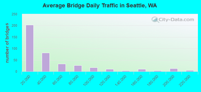
- 16,995,808Total average daily traffic
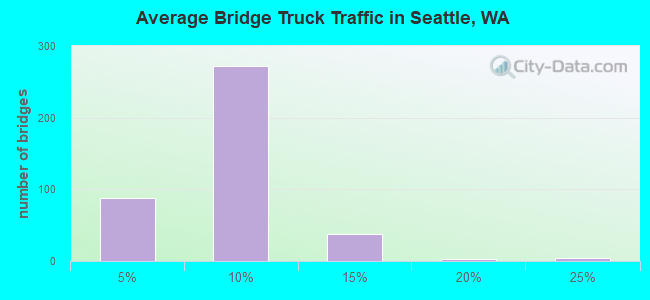
- 1,082,900Total average daily truck traffic
- National Bridge Inventory (NBI) Registered Bridges for Seattle
- No street view available for this location
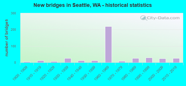
- New bridges - historical statistics
- 61900-1909
- 121910-1919
- 71920-1929
- 261930-1939
- 121940-1949
- 131950-1959
- 2191960-1969
- 91970-1979
- 271980-1989
- 291990-1999
- 252000-2009
- 272010-2019
- 12020-2022
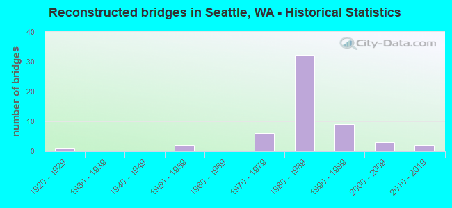
- Reconstructed bridges - Historical Statistics
- 11920-1929
- 01930-1939
- 01940-1949
- 21950-1959
- 01960-1969
- 61970-1979
- 321980-1989
- 91990-1999
- 32000-2009
- 22010-2019
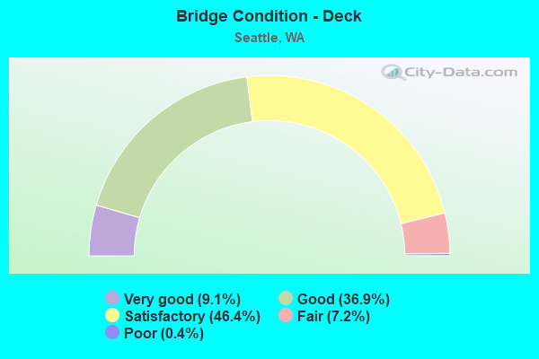
- Bridge Condition - Deck
- 9.1%Very good
- 36.9%Good
- 46.4%Satisfactory
- 7.2%Fair
- 0.4%Poor
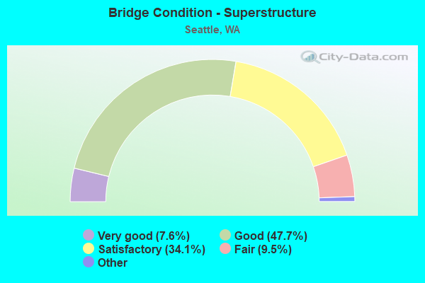
- Bridge Condition - Superstructure
- 7.6%Very good
- 47.7%Good
- 34.1%Satisfactory
- 9.5%Fair
- 1.1%Poor
- 0.4%Critical
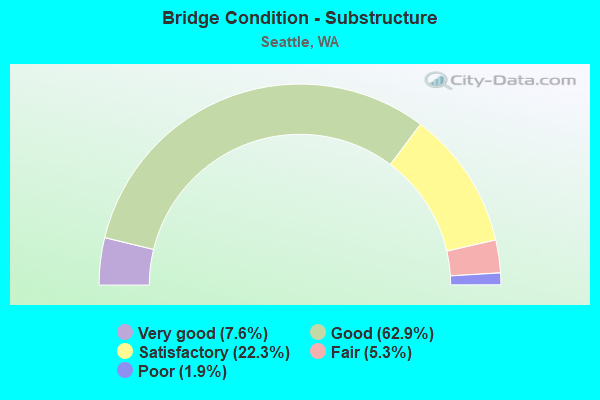
- Bridge Condition - Substructure
- 7.6%Very good
- 62.9%Good
- 22.3%Satisfactory
- 5.3%Fair
- 1.9%Poor
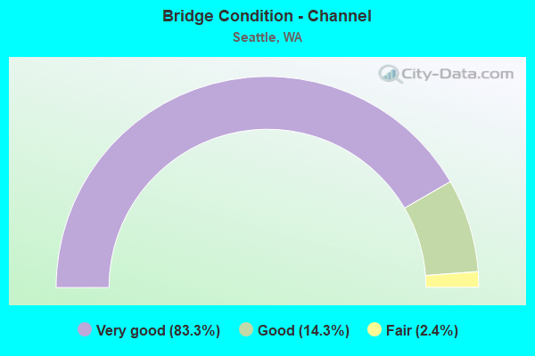
- Bridge Condition - Channel
- 83.3%Very good
- 14.3%Good
- 2.4%Fair
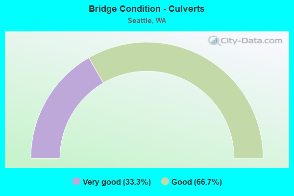
- Bridge Condition - Culverts
- 33.3%Very good
- 66.7%Good
Find on map >> Show street view
Structure Number: 7270B, Location: 3.1 N JCT SR 522 (Lat: 47.723139, Lng: -122.324833), Route carried "under" structure: Interstate 5, Year Built: 1964, Structure Length: 0. m, Average Daily Traffic: 199,698 (year 2019), Truck Traffic: 5%, Features Intersected: I-5, Facility Carried by Structure: NE 130TH ST
Minimum Vertical Clearance: 5.33m (17.49ft), Kilometerpoint: 279.752, Lanes on structure: 4, Lanes under structure: 10, Material/Design: Concrete continuous, Design/Construction: Box Beam or Girders - Multiple, Length of Maximum Span: 22.9m (75.1ft)
Find on map >> Show street view
Structure Number: 7409A, Location: 1.2 N JCT I-90 (Lat: 47.610628, Lng: -122.330894), Route carried "under" structure: Interstate 5, Year Built: 1964, Structure Length: 0. m, Average Daily Traffic: 181,101 (year 2019), Truck Traffic: 5%, Features Intersected: I-5, Facility Carried by Structure: 8TH AVE
Minimum Vertical Clearance: 4.93m (16.17ft), Kilometerpoint: 266.845, Lanes on structure: 2, Lanes under structure: 18, Material/Design: Concrete continuous, Design/Construction: Box Beam or Girders - Multiple, Length of Maximum Span: 43.9m (144.0ft)
Find on map >> Show street view
Structure Number: 7409B, Location: 1.2 N JCT I-90 (Lat: 47.609528, Lng: -122.331667), Route carried "under" structure: Interstate 5, Year Built: 1965, Structure Length: 0. m, Average Daily Traffic: 90,551 (year 2019), Truck Traffic: 5%, Features Intersected: I-5, Facility Carried by Structure: UNIV-N RAMP
Minimum Vertical Clearance: 6.91m (22.67ft), Kilometerpoint: 266.749, Lanes on structure: 1, Lanes under structure: 6, Material/Design: Concrete continuous, Design/Construction: Box Beam or Girders - Multiple, Length of Maximum Span: 47.5m (155.8ft)
Find on map >> Show street view
Structure Number: 7409C, Location: 1.6 N JCT I-90 (Lat: 47.612508, Lng: -122.331056), Route carried "under" structure: Interstate 5, Year Built: 1964, Structure Length: 0. m, Average Daily Traffic: 204,392 (year 2019), Truck Traffic: 5%, Features Intersected: I-5, Facility Carried by Structure: PIKE ST
Minimum Vertical Clearance: 6.78m (22.24ft), Kilometerpoint: 267.103, Lanes on structure: 2, Lanes under structure: 13, Material/Design: Concrete continuous, Design/Construction: Box Beam or Girders - Multiple, Length of Maximum Span: 40.8m (133.9ft)
Find on map >> Show street view
Structure Number: 7409D, Location: 1.6 N JCT I-90 (Lat: 47.614167, Lng: -122.330556), Route carried "under" structure: Interstate 5, Year Built: 1965, Structure Length: 0. m, Average Daily Traffic: 204,392 (year 2019), Truck Traffic: 5%, Features Intersected: I-5, Facility Carried by Structure: PINE ST-BOREN AVE
Minimum Vertical Clearance: 11.94m (39.17ft), Kilometerpoint: 267.248, Lanes on structure: 3, Lanes under structure: 14, Material/Design: Concrete continuous, Design/Construction: Box Beam or Girders - Multiple, Length of Maximum Span: 37.2m (122.0ft)
Find on map >> Show street view
Structure Number: 7504E, Location: 1.2 N JCT I-90 (Lat: 47.601711, Lng: -122.325864), Route carried "under" structure: Interstate 5, Year Built: 1965, Structure Length: 0. m, Average Daily Traffic: 146,552 (year 2019), Truck Traffic: 8%, Features Intersected: I-5, Facility Carried by Structure: YESLER WAY
Minimum Vertical Clearance: 7.95m (26.08ft), Kilometerpoint: 265.703, Lanes on structure: 2, Lanes under structure: 15, Material/Design: Concrete continuous, Design/Construction: Box Beam or Girders - Multiple, Length of Maximum Span: 28.3m (92.8ft)
Find on map >> Show street view
Structure Number: 7565A, Location: 6.9 N JCT SR 900 (Lat: 47.590861, Lng: -122.320806), Route carried "under" structure: Interstate 5, Year Built: 1966, Structure Length: 0. m, Average Daily Traffic: 146,552 (year 2019), Truck Traffic: 8%, Features Intersected: I-5, Facility Carried by Structure: N-W RAMP
Minimum Vertical Clearance: 12.42m (40.75ft), Kilometerpoint: 264.592, Lanes on structure: 1, Lanes under structure: 18, Material/Design: Concrete continuous, Design/Construction: Box Beam or Girders - Multiple, Length of Maximum Span: 42.7m (140.1ft)
Find on map >> Show street view
Structure Number: 7565B, Location: 6.9 N JCT SR 900 (Lat: 47.593861, Lng: -122.319861), Route carried "under" structure: Interstate 5, Year Built: 1965, Structure Length: 0. m, Average Daily Traffic: 146,552 (year 2019), Truck Traffic: 8%, Features Intersected: I-5, Facility Carried by Structure: I-90 W-S RAMP
Minimum Vertical Clearance: 5.51m (18.08ft), Kilometerpoint: 264.705, Lanes on structure: 1, Lanes under structure: 10, Material/Design: Concrete continuous, Design/Construction: Box Beam or Girders - Multiple, Length of Maximum Span: 26.2m (86.0ft)
Find on map >> Show street view
Structure Number: 7565C, Location: 6.9 N JCT SR 900 (Lat: 47.591667, Lng: -122.318333), Route carried "under" structure: Interstate 5, Year Built: 1966, Structure Length: 0. m, Average Daily Traffic: 146,552 (year 2019), Truck Traffic: 8%, Features Intersected: I-5, Facility Carried by Structure: I-90
Minimum Vertical Clearance: 5.87m (19.26ft), Kilometerpoint: 264.721, Lanes on structure: 2, Lanes under structure: 10, Material/Design: Prestressed concrete continuous, Design/Construction: Box Beam or Girders - Multiple, Length of Maximum Span: 39.6m (129.9ft)
Find on map >> Show street view
Structure Number: 7565D, Location: 6.9 N JCT SR 900 (Lat: 47.593472, Lng: -122.321944), Route carried "under" structure: Interstate 5, Year Built: 1965, Structure Length: 0. m, Average Daily Traffic: 146,552 (year 2019), Truck Traffic: 8%, Features Intersected: I-5, Facility Carried by Structure: E-N RAMP
Minimum Vertical Clearance: 7.85m (25.75ft), Kilometerpoint: 264.737, Lanes on structure: 1, Lanes under structure: 11, Material/Design: Concrete continuous, Design/Construction: Box Beam or Girders - Multiple, Length of Maximum Span: 39.6m (129.9ft)
Find on map >> Show street view
Structure Number: 7565E, Location: 6.9 N JCT SR 900 (Lat: 47.596122, Lng: -122.320775), Route carried "under" structure: Interstate 5, Year Built: 1965, Structure Length: 0. m, Average Daily Traffic: 146,552 (year 2019), Truck Traffic: 8%, Features Intersected: I-5, RAMPS, RAILROAD
Minimum Vertical Clearance: 9.25m (30.35ft), Kilometerpoint: 264.850, Lanes on structure: 2, Lanes under structure: 7, Material/Design: Concrete continuous, Design/Construction: Box Beam or Girders - Multiple, Length of Maximum Span: 42.7m (140.1ft)
Find on map >> Show street view
Structure Number: 7565F, Location: JCT I-90 (Lat: 47.595528, Lng: -122.320278), Route carried "under" structure: City street 5, Year Built: 1965, Structure Length: 0. m, Average Daily Traffic: 21,770 (year 2010), Truck Traffic: 5%, Features Intersected: DEARBORN ST
Minimum Vertical Clearance: 6.58m (21.59ft), Kilometerpoint: 0.097, Lanes on structure: 4, Lanes under structure: 6, Material/Design: Concrete continuous, Design/Construction: Box Beam or Girders - Multiple, Length of Maximum Span: 29.3m (96.1ft)
Find on map >> Show street view
Structure Number: 7565G, Location: JCT I-90 (Lat: 47.595528, Lng: -122.320528), Route carried "under" structure: City street 5, Year Built: 1965, Structure Length: 0. m, Average Daily Traffic: 21,770 (year 2010), Truck Traffic: 5%, Features Intersected: DEARBORN ST
Minimum Vertical Clearance: 6.53m (21.42ft), Kilometerpoint: 0.080, Lanes on structure: 3, Lanes under structure: 6, Material/Design: Concrete continuous, Design/Construction: Box Beam or Girders - Multiple, Length of Maximum Span: 29.3m (96.1ft)
Find on map >> Show street view
Structure Number: 7565I, Location: JCT I-90 (Lat: 47.595528, Lng: -122.319750), Route carried "under" structure: City street 5, Year Built: 1965, Structure Length: 0. m, Average Daily Traffic: 21,770 (year 2010), Truck Traffic: 5%, Features Intersected: DEARBORN ST
Minimum Vertical Clearance: 7.39m (24.25ft), Kilometerpoint: 0.145, Lanes on structure: 2, Lanes under structure: 6, Material/Design: Concrete continuous, Design/Construction: Box Beam or Girders - Multiple, Length of Maximum Span: 29.3m (96.1ft)
Find on map >> Show street view
Structure Number: 7565J, Location: JCT I-90 (Lat: 47.595528, Lng: -122.320972), Route carried "under" structure: City street 5, Year Built: 1965, Structure Length: 0. m, Average Daily Traffic: 21,770 (year 2010), Truck Traffic: 5%, Features Intersected: DEARBORN ST
Minimum Vertical Clearance: 6.78m (22.24ft), Kilometerpoint: 0.048, Lanes on structure: 4, Lanes under structure: 5, Material/Design: Concrete continuous, Design/Construction: Box Beam or Girders - Multiple, Length of Maximum Span: 29.3m (96.1ft)
Find on map >> Show street view
Structure Number: 7565K, Location: JCT I-90 (Lat: 47.593278, Lng: -122.321611), Route carried "under" structure: City street , Year Built: 1966, Structure Length: 0. m, Average Daily Traffic: 5,480 (year 2008), Truck Traffic: 5%, Features Intersected: AIRPORT WAY S, Facility Carried by Structure: S-W RAMP
Minimum Vertical Clearance: 6.91m (22.67ft), Kilometerpoint: 0.257, Lanes on structure: 2, Lanes under structure: 3, Material/Design: Concrete continuous, Design/Construction: Box Beam or Girders - Multiple, Length of Maximum Span: 28.0m (91.9ft)
Find on map >> Show street view
Structure Number: 7565L, Location: JCT I-90 (Lat: 47.594861, Lng: -122.317306), Route carried "under" structure: City street 5, Year Built: 1965, Structure Length: 0. m, Average Daily Traffic: 20,500 (year 2011), Truck Traffic: 5%, Features Intersected: DEARBORN STREET, Facility Carried by Structure: I-90 WCD RAMP
Minimum Vertical Clearance: 7.49m (24.57ft), Kilometerpoint: 0.161, Lanes on structure: 2, Lanes under structure: 6, Material/Design: Concrete continuous, Design/Construction: Box Beam or Girders - Multiple, Length of Maximum Span: 36.6m (120.1ft)
Find on map >> Show street view
Structure Number: 7565M, Location: JCT I-90 (Lat: 47.594611, Lng: -122.318833), Route carried "under" structure: Interstate 5, Year Built: 1965, Structure Length: 0. m, Average Daily Traffic: 15,180 (year 2012), Truck Traffic: 5%, Features Intersected: I-5 NBCD, Facility Carried by Structure: DEARBORN-N RAMP
Minimum Vertical Clearance: 5.31m (17.42ft), Kilometerpoint: 1.127, Lanes on structure: 1, Lanes under structure: 1, Material/Design: Concrete continuous, Design/Construction: Box Beam or Girders - Multiple, Length of Maximum Span: 40.2m (131.9ft)
Find on map >> Show street view
Structure Number: 7565P, Location: JCT I-5 (Lat: 47.592278, Lng: -122.326222), Route carried "under" structure: Interstate 90, Year Built: 1966, Structure Length: 0. m, Average Daily Traffic: 11,680 (year 2019), Truck Traffic: 4%, Features Intersected: I-5
Minimum Vertical Clearance: 4.95m (16.24ft), Kilometerpoint: 4.184, Lanes on structure: 2, Lanes under structure: 29, Material/Design: Prestressed concrete continuous, Design/Construction: Box Beam or Girders - Multiple, Length of Maximum Span: 39.6m (129.9ft)
Find on map >> Show street view
Structure Number: 7675A, Location: 3.9 N JCT SR 900 (Lat: 47.548264, Lng: -122.312333), Route carried "under" structure: Interstate 5, Year Built: 1966, Structure Length: 0. m, Average Daily Traffic: 204,857 (year 2019), Truck Traffic: 8%, Features Intersected: I-5, Facility Carried by Structure: ALBRO ST
Minimum Vertical Clearance: 6.30m (20.67ft), Kilometerpoint: 259.442, Lanes on structure: 4, Lanes under structure: 14, Material/Design: Concrete continuous, Design/Construction: Box Beam or Girders - Multiple, Length of Maximum Span: 24.7m (81.0ft)
Find on map >> Show street view
Structure Number: 7686B, Location: 6.5 N JCT SR 900 (Lat: 47.586111, Lng: -122.322222), Route carried "under" structure: Interstate 5, Year Built: 1966, Structure Length: 0. m, Average Daily Traffic: 257,207 (year 2019), Truck Traffic: 8%, Features Intersected: I-5, Facility Carried by Structure: BEACON-HOLGATE
Minimum Vertical Clearance: 9.60m (31.50ft), Kilometerpoint: 263.868, Lanes on structure: 2, Lanes under structure: 15, Material/Design: Concrete continuous, Design/Construction: Box Beam or Girders - Multiple, Length of Maximum Span: 31.7m (104.0ft)
Find on map >> Show street view
Structure Number: 7734A, Location: 3.9 N JCT SR 900 (Lat: 47.551667, Lng: -122.317083), Route carried "under" structure: Ramp Interstate 5, Year Built: 1966, Structure Length: 0. m, Average Daily Traffic: 3,978 (year 2012), Truck Traffic: 8%, Features Intersected: N-W RAMP
Minimum Vertical Clearance: 5.00m (16.40ft), Kilometerpoint: 0.595, Lanes on structure: 5, Lanes under structure: 1, Material/Design: Concrete continuous, Design/Construction: Box Beam or Girders - Multiple, Length of Maximum Span: 32.6m (107.0ft)
Find on map >> Show street view
Structure Number: 7734D, Location: 3.9 N JCT SR 900 (Lat: 47.549111, Lng: -122.313861), Route carried "under" structure: Interstate 5, Year Built: 1966, Structure Length: 0. m, Average Daily Traffic: 204,857 (year 2019), Truck Traffic: 8%, Features Intersected: I-5, Facility Carried by Structure: E-N RAMP
Minimum Vertical Clearance: 5.84m (19.16ft), Kilometerpoint: 259.603, Lanes on structure: 2, Lanes under structure: 11, Material/Design: Concrete continuous, Design/Construction: Box Beam or Girders - Multiple, Length of Maximum Span: 32.3m (106.0ft)
Find on map >> Show street view
Structure Number: 7741G, Location: 5.6 N JCT SR 900 (Lat: 47.569758, Lng: -122.319794), Route carried "under" structure: Interstate 5, Year Built: 1967, Structure Length: 0. m, Average Daily Traffic: 197,594 (year 2019), Truck Traffic: 8%, Features Intersected: W-S, I5, EB W SEA FRWY
Minimum Vertical Clearance: 9.93m (32.58ft), Kilometerpoint: 262.098, Lanes on structure: 1, Lanes under structure: 17, Material/Design: Concrete continuous, Design/Construction: Box Beam or Girders - Multiple, Length of Maximum Span: 43.0m (141.1ft)
Find on map >> Show street view
Structure Number: 7741H, Location: 5.6 N JCT SR 900 (Lat: 47.571167, Lng: -122.320744), Route carried "under" structure: Ramp Interstate 5, Year Built: 1967, Structure Length: 0. m, Average Daily Traffic: 28,260 (year 2012), Truck Traffic: 5%, Features Intersected: E-6TH RAMP EB LANES
Minimum Vertical Clearance: 6.30m (20.67ft), Kilometerpoint: 0.370, Lanes on structure: 1, Lanes under structure: 8, Material/Design: Concrete continuous, Design/Construction: Box Beam or Girders - Multiple, Length of Maximum Span: 31.7m (104.0ft)
Find on map >> Show street view
Structure Number: 7741J, Location: 5.6 N JCT SR 900 (Lat: 47.571778, Lng: -122.320306), Route carried "under" structure: Interstate 5, Year Built: 1966, Structure Length: 0. m, Average Daily Traffic: 197,594 (year 2019), Truck Traffic: 8%, Features Intersected: I-5, Facility Carried by Structure: E-N RAMP
Minimum Vertical Clearance: 5.21m (17.09ft), Kilometerpoint: 262.291, Lanes on structure: 1, Lanes under structure: 8, Material/Design: Concrete continuous, Design/Construction: Box Beam or Girders - Multiple, Length of Maximum Span: 33.8m (110.9ft)
Find on map >> Show street view
Structure Number: 7741M, Location: 5.6 N JCT SR 900 (Lat: 47.572550, Lng: -122.319656), Route carried "under" structure: Interstate 5, Year Built: 1967, Structure Length: 0. m, Average Daily Traffic: 197,594 (year 2019), Truck Traffic: 8%, Features Intersected: I-5 MAINLINE AND RAMPS, Facility Carried by Structure: W-S RAMP
Minimum Vertical Clearance: 13.54m (44.42ft), Kilometerpoint: 262.307, Lanes on structure: 1, Lanes under structure: 14, Material/Design: Concrete continuous, Design/Construction: Box Beam or Girders - Multiple, Length of Maximum Span: 31.4m (103.0ft)
Find on map >> Show street view
Structure Number: 7741N, Location: 5.5 N JCT SR 900 (Lat: 47.571161, Lng: -122.324450), Route carried "under" structure: City street , Year Built: 1967, Structure Length: 0. m, Average Daily Traffic: 2,500 (year 2020), Truck Traffic: 10%, Features Intersected: E-S RAMP BR, Facility Carried by Structure: I-5
Minimum Vertical Clearance: 6.15m (20.18ft), Kilometerpoint: 3.042, Lanes on structure: 1, Lanes under structure: 5, Material/Design: Concrete continuous, Design/Construction: Box Beam or Girders - Multiple, Length of Maximum Span: 28.0m (91.9ft)
Find on map >> Show street view
Structure Number: 7741O, Location: 5.5 N JCT SR 900 (Lat: 47.571083, Lng: -122.324000), Route carried "under" structure: City street , Year Built: 1967, Structure Length: 0. m, Average Daily Traffic: 2,500 (year 2020), Truck Traffic: 10%, Features Intersected: 6TH-S RAMP BR, Facility Carried by Structure: I-5
Minimum Vertical Clearance: 5.36m (17.59ft), Kilometerpoint: 3.026, Lanes on structure: 1, Lanes under structure: 5, Material/Design: Concrete continuous, Design/Construction: Box Beam or Girders - Multiple, Length of Maximum Span: 27.4m (89.9ft)
Find on map >> Show street view
Structure Number: 7741P, Location: 5.6 N JCT SR 900 (Lat: 47.574281, Lng: -122.320175), Route carried "under" structure: Interstate 5, Year Built: 1967, Structure Length: 0. m, Average Daily Traffic: 197,594 (year 2019), Truck Traffic: 8%, Features Intersected: S-E RAMP TO COLUMBIA WAY
Minimum Vertical Clearance: 6.40m (21.00ft), Kilometerpoint: 262.404, Lanes on structure: 1, Lanes under structure: 9, Material/Design: Concrete continuous, Design/Construction: Box Beam or Girders - Multiple, Length of Maximum Span: 40.8m (133.9ft)
Find on map >> Show street view
Structure Number: 7741R, Location: 5.6 N JCT SR 900 (Lat: 47.573222, Lng: -122.315944), Route carried "under" structure: Interstate 5, Year Built: 1967, Structure Length: 0. m, Average Daily Traffic: 197,594 (year 2019), Truck Traffic: 8%, Features Intersected: I-5, Facility Carried by Structure: SPOKANE ST WB LANE
Minimum Vertical Clearance: 12.09m (39.67ft), Kilometerpoint: 262.355, Lanes on structure: 2, Lanes under structure: 24, Material/Design: Concrete continuous, Design/Construction: Box Beam or Girders - Multiple, Length of Maximum Span: 36.6m (120.1ft)
Find on map >> Show street view
Structure Number: 7741T, Location: 5.6 N JCT SR 900 (Lat: 47.571472, Lng: -122.326167), Route carried "under" structure: Interstate 5, Year Built: 1966, Structure Length: 0. m, Average Daily Traffic: 197,594 (year 2019), Truck Traffic: 8%, Features Intersected: I-5, Facility Carried by Structure: SPOKANE ST EB LANE
Minimum Vertical Clearance: 9.55m (31.33ft), Kilometerpoint: 262.275, Lanes on structure: 2, Lanes under structure: 18, Material/Design: Concrete continuous, Design/Construction: Box Beam or Girders - Multiple, Length of Maximum Span: 35.4m (116.1ft)
Find on map >> Show street view
Structure Number: 7882A, Location: 3.8 N JCT SR 900 (Lat: 47.548425, Lng: -122.317722), Route carried "under" structure: City street 5, Year Built: 1966, Structure Length: 0. m, Average Daily Traffic: 13,467 (year 2020), Truck Traffic: 5%, Features Intersected: CITY STS, RAMP & RR
Minimum Vertical Clearance: 8.53m (27.99ft), Kilometerpoint: 5.697, Lanes on structure: 3, Lanes under structure: 4, Material/Design: Concrete continuous, Design/Construction: Box Beam or Girders - Multiple, Length of Maximum Span: 33.8m (110.9ft)
Find on map >> Show street view
Structure Number: 8155F, Location: 0.2 E JCT I-5 (Lat: 47.594433, Lng: -122.316822), Route carried "under" structure: Interstate 90, Year Built: 1968, Structure Length: 0. m, Average Daily Traffic: 11,680 (year 2019), Truck Traffic: 4%, Features Intersected: I-90, Facility Carried by Structure: 12TH AVE S
Minimum Vertical Clearance: 12.19m (39.99ft), Kilometerpoint: 4.377, Lanes on structure: 4, Lanes under structure: 5, Material/Design: Steel, Design/Construction: Stringer/Multi-beam, Length of Maximum Span: 38.4m (126.0ft)
Find on map >> Show street view
Structure Number: 8155F, Location: 0.2 E JCT I-5 (Lat: 47.594433, Lng: -122.316822), Route carried "under" structure: Interstate 90, Year Built: 1968, Structure Length: 0. m, Average Daily Traffic: 11,680 (year 2019), Truck Traffic: 4%, Features Intersected: I-90, Facility Carried by Structure: 12TH AVE S
Minimum Vertical Clearance: 6.10m (20.01ft), Kilometerpoint: 4.377, Lanes on structure: 4, Lanes under structure: 5, Material/Design: Steel, Design/Construction: Stringer/Multi-beam, Length of Maximum Span: 38.4m (126.0ft)
Find on map >> Show street view
Structure Number: 8195A, Location: 2.2 N JCT I-90 (Lat: 47.625436, Lng: -122.330056), Route carried "under" structure: Ramp Interstate 5, Year Built: 1967, Structure Length: 0. m, Average Daily Traffic: 22,473 (year 2012), Truck Traffic: 5%, Features Intersected: N-W RAMP E-N RAMP
Minimum Vertical Clearance: 5.13m (16.83ft), Kilometerpoint: 0.338, Lanes on structure: 1, Lanes under structure: 2, Material/Design: Steel, Design/Construction: Stringer/Multi-beam, Length of Maximum Span: 27.1m (88.9ft)
Find on map >> Show street view
Structure Number: 8276F, Location: 4.0 N JCT SR 518 (Lat: 47.524750, Lng: -122.334111), Route carried "under" structure: State highway 509, Year Built: 1968, Structure Length: 0. m, Average Daily Traffic: 49,601 (year 2019), Truck Traffic: 2%, Features Intersected: N-N RAMP
Minimum Vertical Clearance: 7.65m (25.10ft), Kilometerpoint: 47.476, Lanes on structure: 1, Lanes under structure: 6, Material/Design: Concrete continuous, Design/Construction: Box Beam or Girders - Multiple, Length of Maximum Span: 45.7m (149.9ft)
Find on map >> Show street view
Structure Number: 8276G, Location: 4.0 N JCT SR 518 (Lat: 47.526472, Lng: -122.334111), Route carried "under" structure: State highway 509, Year Built: 1968, Structure Length: 0. m, Average Daily Traffic: 49,601 (year 2019), Truck Traffic: 2%, Features Intersected: SR 509, Facility Carried by Structure: CLOVERDALE ST
Minimum Vertical Clearance: 6.15m (20.18ft), Kilometerpoint: 47.620, Lanes on structure: 4, Lanes under structure: 7, Material/Design: Steel, Design/Construction: Stringer/Multi-beam, Length of Maximum Span: 25.9m (85.0ft)
Find on map >> Show street view
Structure Number: 12197A, Location: 2.0 N JCT SR 522 (Lat: 47.708278, Lng: -122.329750), Route carried "under" structure: City street , Year Built: 1964, Structure Length: 0. m, Average Daily Traffic: 45,581 (year 2020), Truck Traffic: 5%, Features Intersected: NE NORTHGATE WAY, Facility Carried by Structure: I-5
Minimum Vertical Clearance: 5.23m (17.16ft), Kilometerpoint: 0.129, Lanes on structure: 5, Lanes under structure: 4, Material/Design: Prestressed concrete, Design/Construction: Stringer/Multi-beam, Length of Maximum Span: 24.4m (80.1ft)
Find on map >> Show street view
Structure Number: 12659A, Location: JCT I-5 (Lat: 47.593889, Lng: -122.320028), Route carried "under" structure: Interstate 90, Year Built: 1988, Structure Length: 0. m, Average Daily Traffic: 11,680 (year 2019), Truck Traffic: 4%, Features Intersected: I-90 WB
Minimum Vertical Clearance: 4.88m (16.01ft), Kilometerpoint: 4.442, Lanes on structure: 4, Lanes under structure: 4, Material/Design: Concrete continuous, Design/Construction: Box Beam or Girders - Multiple, Length of Maximum Span: 30.5m (100.1ft)
Find on map >> Show street view
Structure Number: 13190A, Location: 0.6 E JCT I-5 (Lat: 47.590556, Lng: -122.308028), Route carried "under" structure: City street , Year Built: 1988, Structure Length: 0. m, Average Daily Traffic: 28,381 (year 2009), Truck Traffic: 5%, Features Intersected: RAINIER AVE, Facility Carried by Structure: I-90
Minimum Vertical Clearance: 7.57m (24.84ft), Kilometerpoint: 0.257, Lanes on structure: 5, Lanes under structure: 6, Material/Design: Prestressed concrete continuous, Design/Construction: Box Beam or Girders - Multiple, Length of Maximum Span: 36.9m (121.1ft)
Find on map >> Show street view
Structure Number: 13706B, Location: 0.1 N JCT I-90 (Lat: 47.593417, Lng: -122.329750), Route carried "under" structure: State highway 519, Year Built: 1991, Structure Length: 0. m, Average Daily Traffic: 27,000 (year 2010), Truck Traffic: 11%, Features Intersected: CITY STREETS, Facility Carried by Structure: I-90
Minimum Vertical Clearance: 6.50m (21.33ft), Kilometerpoint: 0.467, Lanes on structure: 2, Lanes under structure: 7, Material/Design: Prestressed concrete continuous, Design/Construction: Box Beam or Girders - Single/Spread, Length of Maximum Span: 70.1m (230.0ft)
Find on map >> Show street view
Structure Number: 13725E, Location: 0.6 E JCT I-5 (Lat: 47.590111, Lng: -122.307056), Route carried "under" structure: City street 90, Year Built: 1992, Structure Length: 0. m, Average Daily Traffic: 28,381 (year 2009), Truck Traffic: 5%, Features Intersected: RAINIER AVE S, Facility Carried by Structure: PEDESTRIAN
Minimum Vertical Clearance: 6.91m (22.67ft), Kilometerpoint: 0.338, Lanes under structure: 6, Material/Design: Prestressed concrete continuous, Design/Construction: Box Beam or Girders - Single/Spread, Length of Maximum Span: 36.3m (119.1ft)
Find on map >> Show street view
Structure Number: 13725F, Location: 0.6 E JCT I-5 (Lat: 47.589944, Lng: -122.307556), Route carried "under" structure: City street , Year Built: 1992, Structure Length: 0. m, Average Daily Traffic: 28,381 (year 2009), Truck Traffic: 5%, Features Intersected: RAINIER AVE S, Facility Carried by Structure: I-90
Minimum Vertical Clearance: 6.91m (22.67ft), Kilometerpoint: 0.354, Lanes on structure: 5, Lanes under structure: 6, Material/Design: Prestressed concrete continuous, Design/Construction: Box Beam or Girders - Multiple, Length of Maximum Span: 36.0m (118.1ft)
Find on map >> Show street view
Structure Number: 13725G, Location: 0.7 E JCT I-5 (Lat: 47.589750, Lng: -122.305444), Route carried "under" structure: Ramp Interstate 90, Year Built: 1992, Structure Length: 0. m, Average Daily Traffic: 8,799 (year 2012), Truck Traffic: 2%, Features Intersected: SR 90 RAMP, Facility Carried by Structure: PEDESTRIAN
Minimum Vertical Clearance: 5.46m (17.91ft), Kilometerpoint: 0.129, Lanes under structure: 2, Material/Design: Concrete, Design/Construction: Box Beam or Girders - Single/Spread, Length of Maximum Span: 37.5m (123.0ft)
Find on map >> Show street view
Structure Number: 14325A, Location: 0.6 E JCT I-5 (Lat: 47.589611, Lng: -122.308778), Route carried "under" structure: Ramp Interstate 90, Year Built: 1995, Structure Length: 0. m, Average Daily Traffic: 6,034 (year 2012), Truck Traffic: 3%, Features Intersected: I-90 RAMP EB TO RAINIER, Facility Carried by Structure: BICYCLE/PEDESTR.
Minimum Vertical Clearance: 5.46m (17.91ft), Kilometerpoint: 0.435, Lanes under structure: 1, Material/Design: Concrete, Design/Construction: Box Beam or Girders - Single/Spread, Length of Maximum Span: 32.9m (107.9ft)
Find on map >> Show street view
Structure Number: 14407A, Location: W END MARION ST (Lat: 47.586667, Lng: -122.338333), Route carried "under" structure: State highway 519, Year Built: 1994, Structure Length: 0. m, Average Daily Traffic: 12,000 (year 2010), Truck Traffic: 1%, Features Intersected: SR 519, Facility Carried by Structure: PEDESTRIANS
Minimum Vertical Clearance: 4.88m (16.01ft), Kilometerpoint: 1.835, Lanes under structure: 2, Toll: Toll bridge, Material/Design: Steel, Design/Construction: Movable - Lift, Length of Maximum Span: 26.8m (87.9ft)
Find on map >> Show street view
Structure Number: 14459A, Location: 0.1 N JCT SR 509 (Lat: 47.537944, Lng: -122.335000), Route carried "under" structure: State highway 99, Year Built: 1996, Structure Length: 0. m, Average Daily Traffic: 26,351 (year 2019), Truck Traffic: 15%, Features Intersected: DUWAMISH RIVER
Minimum Vertical Clearance: 6.93m (22.74ft), Kilometerpoint: 42.519, Lanes on structure: 3, Lanes under structure: 4, Material/Design: Steel, Design/Construction: Movable - Bascule, Length of Maximum Span: 89.6m (294.0ft)
Find on map >> Show street view
Structure Number: 14539A, Location: 2.0 N JCT SR 522 (Lat: 47.708414, Lng: -122.329439), Route carried "under" structure: City street , Year Built: 1995, Structure Length: 0. m, Average Daily Traffic: 45,581 (year 2020), Truck Traffic: 5%, Features Intersected: NORTHGATE WAY, Facility Carried by Structure: I-5 RAMP
Minimum Vertical Clearance: 5.31m (17.42ft), Kilometerpoint: 0.145, Lanes on structure: 2, Lanes under structure: 4, Material/Design: Prestressed concrete, Design/Construction: Stringer/Multi-beam, Length of Maximum Span: 24.4m (80.1ft)
Find on map >> Show street view
Structure Number: 15983A, Location: 0.2 W JCT I-90 (Lat: 47.590200, Lng: -122.329444), Route carried "under" structure: City street 519, Year Built: 2002, Structure Length: 0. m, Average Daily Traffic: 12,840 (year 2016), Truck Traffic: 2%, Features Intersected: STADIUM,BNSFRR,4TH AVE
Minimum Vertical Clearance: 6.78m (22.24ft), Kilometerpoint: 0.225, Lanes on structure: 4, Lanes under structure: 4, Material/Design: Steel continuous, Design/Construction: Stringer/Multi-beam, Length of Maximum Span: 46.9m (153.9ft)
Find on map >> Show street view
Structure Number: 15983B, Location: 0.2 W JCT I-90 (Lat: 47.591111, Lng: -122.329306), Route carried "under" structure: City street 519, Year Built: 2003, Structure Length: 0. m, Average Daily Traffic: 6,420 (year 2016), Truck Traffic: 1%, Features Intersected: 4TH AVENUE, Facility Carried by Structure: S-E RAMP
Minimum Vertical Clearance: 6.63m (21.75ft), Kilometerpoint: 0.241, Lanes on structure: 2, Lanes under structure: 2, Material/Design: Concrete continuous, Design/Construction: Box Beam or Girders - Multiple, Length of Maximum Span: 27.4m (89.9ft)
Find on map >> Show street view
Structure Number: 16603A, Location: 6.9 N JCT SR 509 (Lat: 47.632361, Lng: -122.343556), Route carried "under" structure: State highway 99, Year Built: 2004, Structure Length: 0. m, Average Daily Traffic: 60,140 (year 2019), Truck Traffic: 4%, Features Intersected: SR 99/AURORA AVE N, Facility Carried by Structure: GALER ST PED
Minimum Vertical Clearance: 5.33m (17.49ft), Kilometerpoint: 53.720, Lanes under structure: 6, Material/Design: Prestressed concrete, Design/Construction: Box Beam or Girders - Single/Spread, Length of Maximum Span: 31.1m (102.0ft)
Find on map >> Show street view
Structure Number: 17597A, Location: 0.4 W JCT I-5 (Lat: 47.592111, Lng: -122.327528), Route carried "under" structure: City street 519, Year Built: 2010, Structure Length: 0. m, Average Daily Traffic: 12,840 (year 2016), Truck Traffic: 2%, Features Intersected: 4TH AVE AND SOUND TRANS, Facility Carried by Structure: I-90 W-N RAMP
Minimum Vertical Clearance: 5.28m (17.32ft), Kilometerpoint: 0.402, Lanes on structure: 2, Lanes under structure: 4, Material/Design: Prestressed concrete, Design/Construction: Box Beam or Girders - Multiple, Length of Maximum Span: 84.1m (275.9ft)
Find on map >> Show street view
Structure Number: 18290A, Location: 3.7 N JCT SR 509 (Lat: 47.591533, Lng: -122.336089), Route carried "under" structure: State highway 99, Year Built: 2013, Structure Length: 0. m, Average Daily Traffic: 31,837 (year 2019), Truck Traffic: 4%, Features Intersected: SR 99, Facility Carried by Structure: COLORADO AVE
Minimum Vertical Clearance: 6.02m (19.75ft), Kilometerpoint: 48.876, Lanes on structure: 2, Lanes under structure: 4, Material/Design: Prestressed concrete continuous, Design/Construction: Box Beam or Girders - Multiple, Length of Maximum Span: 36.9m (121.1ft)
Find on map >> Show street view
Structure Number: 18549C, Location: 5.7 N JCT SR 509 (Lat: 47.624433, Lng: -122.343769), Route carried "under" structure: City street , Year Built: 2015, Structure Length: 0. m, Average Daily Traffic: 27,602 (year 2020), Truck Traffic: 7%, Features Intersected: MERCER ST, Facility Carried by Structure: SR 99
Minimum Vertical Clearance: 5.28m (17.32ft), Kilometerpoint: 1.947, Lanes on structure: 7, Lanes under structure: 7, Toll: On toll road, Material/Design: Prestressed concrete, Design/Construction: Stringer/Multi-beam, Length of Maximum Span: 37.8m (124.0ft)
Find on map >> Show street view
Structure Number: 18625B, Location: 0.1 E JCT SR 513 (Lat: 47.644667, Lng: -122.302056), Route carried "under" structure: Ramp State highway 520, Year Built: 2017, Structure Length: 0. m, Average Daily Traffic: 6,567 (year 2019), Truck Traffic: 3%, Features Intersected: SR 520, Facility Carried by Structure: 24TH AVE E
Minimum Vertical Clearance: 4.75m (15.58ft), Kilometerpoint: 0.982, Lanes on structure: 1, Lanes under structure: 2, Material/Design: Concrete continuous, Design/Construction: Slab, Length of Maximum Span: 13.1m (43.0ft)
Find on map >> Show street view
Structure Number: 200512, Location: 0.4 N JCT SR 520 (Lat: 47.650536, Lng: -122.304247), Route carried "under" structure: State highway 513, Year Built: 2013, Structure Length: 0. m, Average Daily Traffic: 39,768 (year 2019), Truck Traffic: 3%, Features Intersected: SR 513, Facility Carried by Structure: PEDESTRIANS
Minimum Vertical Clearance: 5.94m (19.49ft), Kilometerpoint: 0.724, Lanes under structure: 5, Material/Design: Concrete continuous, Design/Construction: Box Beam or Girders - Multiple, Length of Maximum Span: 39.9m (130.9ft)
Find on map >> Show street view
Structure Number: 85132, Location: Rainier Ave & MLK JR Way (Lat: 47.575833, Lng: -122.296111), Route carried "under" structure: City street 1140, Year Built: 1976, Structure Length: 0. m, Average Daily Traffic: 35,000 (year 2019), Truck Traffic: 5%, Features Intersected: RAINIER AVE, MLK JR WAY, Facility Carried by Structure: PEDESTRIAN
Minimum Vertical Clearance: 4.78m (15.68ft), Kilometerpoint: 0.001, Lanes under structure: 8, Material/Design: Prestressed concrete, Design/Construction: Tee Beam, Length of Maximum Span: 27.4m (89.9ft)
Find on map >> Show street view
Structure Number: 85133, Location: NE 45th Pl & NE Blakeley (Lat: 47.661944, Lng: -122.291667), Route carried "under" structure: City street 1140, Year Built: 1900, Structure Length: 0. m, Average Daily Traffic: 14,500 (year 2018), Truck Traffic: 5%, Features Intersected: NE 45TH PL, Facility Carried by Structure: PEDESTRIAN
Minimum Vertical Clearance: 4.19m (13.75ft), Kilometerpoint: 0.001, Lanes under structure: 2, Material/Design: Steel, Design/Construction: Stringer/Multi-beam, Length of Maximum Span: 9.8m (32.2ft)
Find on map >> Show street view
Structure Number: 85189, Location: 4500 Delridge Way SW (Lat: 47.563056, Lng: -122.363333), Route carried "under" structure: City street 1140, Year Built: 1960, Structure Length: 0. m, Average Daily Traffic: 20,800 (year 2017), Truck Traffic: 5%, Features Intersected: DELRIDGE WAY, Facility Carried by Structure: PEDESTRIAN
Minimum Vertical Clearance: 4.90m (16.08ft), Kilometerpoint: 228.527, Lanes under structure: 4, Material/Design: Concrete continuous, Design/Construction: Slab, Length of Maximum Span: 18.0m (59.1ft)
Find on map >> Show street view
Structure Number: 85191, Location: 0.25 MI NORTH 35TH AVE SW (Lat: 47.567803, Lng: -122.373611), Route carried "under" structure: City street 1140, Year Built: 1961, Structure Length: 0. m, Average Daily Traffic: 43,000 (year 2019), Truck Traffic: 10%, Features Intersected: FAUNTLEROY SW EXPRESSWAY, Facility Carried by Structure: PEDESTRIAN
Minimum Vertical Clearance: 4.42m (14.50ft), Kilometerpoint: 236.574, Lanes under structure: 4, Material/Design: Concrete continuous, Design/Construction: Slab, Length of Maximum Span: 20.1m (65.9ft)
Find on map >> Show street view
Structure Number: 85249, Location: Pacific St WO Pacific Pl (Lat: 47.651175, Lng: -122.308808), Route carried "under" structure: City street 1140, Year Built: 1970, Structure Length: 0. m, Average Daily Traffic: 50,400 (year 2017), Truck Traffic: 5%, Features Intersected: NE PACIFIC ST, Facility Carried by Structure: PEDESTRIAN
Minimum Vertical Clearance: 5.18m (16.99ft), Kilometerpoint: 0.001, Lanes under structure: 4, Material/Design: Concrete, Design/Construction: Girder and Floorbeam System, Length of Maximum Span: 24.7m (81.0ft)
Find on map >> Show street view
Structure Number: 85255, Location: 15th Ave NO Campus Pkwy (Lat: 47.656308, Lng: -122.312053), Route carried "under" structure: City street 1140, Year Built: 1971, Structure Length: 0. m, Average Daily Traffic: 16,135 (year 2017), Truck Traffic: 5%, Features Intersected: 15TH AVE NE, Facility Carried by Structure: PEDESTRIAN
Minimum Vertical Clearance: 4.88m (16.01ft), Kilometerpoint: 247.839, Lanes under structure: 5, Material/Design: Prestressed concrete continuous, Design/Construction: Tee Beam, Length of Maximum Span: 26.8m (87.9ft)
Find on map >> Show street view
Structure Number: 85374, Location: Lake WA Blvd E & Lynn St (Lat: 47.600000, Lng: -122.329444), Route carried "under" structure: City street 1140, Year Built: 1910, Structure Length: 0. m, Average Daily Traffic: 16,000 (year 2018), Truck Traffic: 5%, Features Intersected: LAKE WASHINGTON BLVD E, Facility Carried by Structure: PEDESTRIAN
Minimum Vertical Clearance: 2.74m (8.99ft), Kilometerpoint: 0.001, Lanes under structure: 2, Material/Design: Concrete, Design/Construction: Arch - Deck, Length of Maximum Span: 9.1m (29.9ft)
Find on map >> Show street view
Structure Number: 85534, Location: Mercer St w/o 4th Ave N (Lat: 47.624722, Lng: -122.350556), Route carried "under" structure: City street 1140, Year Built: 1961, Structure Length: 0. m, Average Daily Traffic: 10,000 (year 2018), Truck Traffic: 5%, Features Intersected: MERCER ST, Facility Carried by Structure: PEDESTRIAN
Minimum Vertical Clearance: 4.80m (15.75ft), Kilometerpoint: 16.254, Lanes under structure: 4, Material/Design: Steel, Design/Construction: Box Beam or Girders - Single/Spread, Length of Maximum Span: 28.0m (91.9ft)
Find on map >> Show street view
Structure Number: 85536, Location: ELLIOTT PARKING GARAGE (Lat: 47.614439, Lng: -122.352200), Route carried "under" structure: City street 1579, Year Built: 1978, Structure Length: 0. m, Average Daily Traffic: 7,000 (year 2017), Truck Traffic: 5%, Features Intersected: ELLIOTT AVE, Facility Carried by Structure: PEDESTRIAN
Minimum Vertical Clearance: 5.03m (16.50ft), Kilometerpoint: 0.676, Lanes under structure: 2, Material/Design: Steel, Design/Construction: Box Beam or Girders - Multiple, Length of Maximum Span: 20.1m (65.9ft)
Find on map >> Show street view
Structure Number: 8554, Location: Stewart St Ped /Western (Lat: 47.609722, Lng: -122.342500), Route carried "under" structure: City street 1140, Year Built: 1930, Structure Length: 0. m, Average Daily Traffic: 10,500 (year 2018), Truck Traffic: 5%, Features Intersected: WESTERN AVE, Facility Carried by Structure: PIKE PLACE MARKET
Minimum Vertical Clearance: 5.59m (18.34ft), Kilometerpoint: 0.001, Lanes under structure: 2, Material/Design: Concrete, Design/Construction: Slab, Length of Maximum Span: 14.3m (46.9ft)
Find on map >> Show street view
Structure Number: 85542, Location: Westin Hotel Skybridge (Lat: 47.613944, Lng: -122.338872), Route carried "under" structure: City street 1140, Year Built: 1982, Structure Length: 0. m, Average Daily Traffic: 11,500 (year 2018), Truck Traffic: 5%, Features Intersected: VIRGINIA ST, Facility Carried by Structure: PEDESTRIAN
Minimum Vertical Clearance: 4.88m (16.01ft), Kilometerpoint: 0.001, Lanes under structure: 3, Material/Design: Steel, Design/Construction: Girder and Floorbeam System, Length of Maximum Span: 20.1m (65.9ft)
Find on map >> Show street view
Structure Number: 85552, Location: Marion St Ped /Western (Lat: 47.603611, Lng: -122.336111), Route carried "under" structure: City street 1140, Year Built: 1976, Structure Length: 0. m, Average Daily Traffic: 9,000 (year 2019), Truck Traffic: 5%, Features Intersected: POST AVE, WESTERN AVE, Facility Carried by Structure: PEDESTRIAN
Minimum Vertical Clearance: 5.11m (16.77ft), Kilometerpoint: 0.001, Lanes under structure: 2, Material/Design: Concrete continuous, Design/Construction: Slab, Length of Maximum Span: 21.3m (69.9ft)
Find on map >> Show street view
Structure Number: 85558, Location: Marion St Ped /Alaskan (Lat: 47.603056, Lng: -122.337500), Route carried "under" structure: City street 1140, Year Built: 1908, Structure Length: 0. m, Average Daily Traffic: 14,300 (year 2016), Truck Traffic: 5%, Features Intersected: ALASKAN WAY, Facility Carried by Structure: PEDESTRIAN
Minimum Vertical Clearance: 6.91m (22.67ft), Kilometerpoint: 0.001, Lanes under structure: 2, Material/Design: Steel continuous, Design/Construction: Girder and Floorbeam System, Length of Maximum Span: 26.5m (86.9ft)
Find on map >> Show street view
Structure Number: 85565, Location: Btwn Jail And Admin blg (Lat: 47.603258, Lng: -122.328894), Route carried "under" structure: City street 1140, Year Built: 1984, Structure Length: 0. m, Average Daily Traffic: 10,760 (year 2018), Truck Traffic: 5%, Features Intersected: 4TH & 5TH AVES, Facility Carried by Structure: PEDESTRIAN
Minimum Vertical Clearance: 24.38m (79.99ft), Kilometerpoint: 243.011, Lanes under structure: 4, Material/Design: Steel, Design/Construction: Truss - Thru, Length of Maximum Span: 49.1m (161.1ft)
Find on map >> Show street view
Structure Number: 85625, Location: 9200 Holman Rd NW (Lat: 47.696111, Lng: -122.372778), Route carried "under" structure: City street 1140, Year Built: 1964, Structure Length: 0. m, Average Daily Traffic: 30,000 (year 2016), Truck Traffic: 5%, Features Intersected: HOLMAN ROAD NW, Facility Carried by Structure: PEDESTRIAN
Minimum Vertical Clearance: 4.88m (16.01ft), Kilometerpoint: 217.261, Lanes under structure: 4, Material/Design: Prestressed concrete, Design/Construction: Tee Beam, Length of Maximum Span: 23.8m (78.1ft)
Find on map >> Show street view
Structure Number: 85779, Location: 0.6 N JCT SR 520 (Lat: 47.652739, Lng: -122.303061), Route carried "under" structure: State highway 513, Year Built: 1938, Structure Length: 0. m, Average Daily Traffic: 43,546 (year 2019), Truck Traffic: 3%, Features Intersected: MONTLAKE BLVD (SR 513), Facility Carried by Structure: PEDESTRIAN
Minimum Vertical Clearance: 4.72m (15.49ft), Kilometerpoint: 0.982, Lanes under structure: 4, Material/Design: Concrete, Design/Construction: Arch - Deck, Length of Maximum Span: 24.4m (80.1ft)
Find on map >> Show street view
Structure Number: 85795, Location: Pine St Ped /Western Ave (Lat: 47.608808, Lng: -122.341542), Route carried "under" structure: City street 1140, Year Built: 1989, Structure Length: 0. m, Average Daily Traffic: 9,500 (year 2018), Truck Traffic: 5%, Features Intersected: WESTERN AVE, Facility Carried by Structure: PEDESTRIAN
Minimum Vertical Clearance: 9.93m (32.58ft), Kilometerpoint: 0.001, Lanes under structure: 2, Material/Design: Steel, Design/Construction: Truss - Thru, Length of Maximum Span: 15.2m (49.9ft)
Find on map >> Show street view
Structure Number: 85886, Location: 11.8 N JCT SR 509 (Lat: 47.702778, Lng: -122.344722), Route carried "under" structure: State highway 99, Year Built: 1961, Structure Length: 0. m, Average Daily Traffic: 31,325 (year 2019), Truck Traffic: 3%, Features Intersected: AURORA AVE N (SR 99), Facility Carried by Structure: PEDESTRIAN
Minimum Vertical Clearance: 5.28m (17.32ft), Kilometerpoint: 61.670, Lanes under structure: 6, Material/Design: Concrete continuous, Design/Construction: Tee Beam, Length of Maximum Span: 29.3m (96.1ft)
Find on map >> Show street view
Structure Number: 85891, Location: 13.2 N JCT SR 509 (Lat: 47.723333, Lng: -122.345000), Route carried "under" structure: State highway 99, Year Built: 1966, Structure Length: 0. m, Average Daily Traffic: 32,060 (year 2018), Truck Traffic: 3%, Features Intersected: AURORA AVE N (SR 99), Facility Carried by Structure: PEDESTRIAN
Minimum Vertical Clearance: 5.13m (16.83ft), Kilometerpoint: 63.923, Lanes under structure: 6, Material/Design: Prestressed concrete, Design/Construction: Tee Beam, Length of Maximum Span: 28.0m (91.9ft)
Find on map >> Show street view
Structure Number: 8594, Location: 8.6 N JCT SR 509 (Lat: 47.656667, Lng: -122.347222), Route carried "under" structure: State highway 99, Year Built: 1935, Structure Length: 0. m, Average Daily Traffic: 47,042 (year 2019), Truck Traffic: 3%, Features Intersected: AURORA AVE N (SR 99), Facility Carried by Structure: PEDESTRIAN
Minimum Vertical Clearance: 4.95m (16.24ft), Kilometerpoint: 56.488, Lanes under structure: 6, Material/Design: Concrete, Design/Construction: Girder and Floorbeam System, Length of Maximum Span: 25.0m (82.0ft)
Find on map >> Show street view
Structure Number: 85945, Location: 9400 Sand Point Way NE (Lat: 47.696667, Lng: -122.276944), Route carried "under" structure: City street 1140, Year Built: 1927, Structure Length: 0. m, Average Daily Traffic: 12,600 (year 2018), Truck Traffic: 5%, Features Intersected: SAND POINT WAY NE, Facility Carried by Structure: PEDESTRIAN
Minimum Vertical Clearance: 5.84m (19.16ft), Kilometerpoint: 0.001, Lanes under structure: 2, Material/Design: Steel, Design/Construction: Stringer/Multi-beam, Length of Maximum Span: 6.7m (22.0ft)
Find on map >> Show street view
Structure Number: 8721, Location: 1505 Westlake Ave N (Lat: 47.632222, Lng: -122.340833), Route carried "under" structure: City street 1140, Year Built: 1995, Structure Length: 0. m, Average Daily Traffic: 4,151 (year 2017), Truck Traffic: 10%, Features Intersected: WESTLAKE AVE N, Facility Carried by Structure: PEDESTRIAN
Minimum Vertical Clearance: 6.10m (20.01ft), Kilometerpoint: 346.009, Lanes under structure: 4, Material/Design: Prestressed concrete continuous, Design/Construction: Stayed Girder, Length of Maximum Span: 26.8m (87.9ft)
Find on map >> Show street view
Structure Number: 87427, Location: Pacific St EO 15th Ave (Lat: 47.652133, Lng: -122.310825), Route carried "under" structure: Other road 1140, Year Built: 1981, Structure Length: 0. m, Average Daily Traffic: 28,000 (year 2018), Truck Traffic: 5%, Features Intersected: NE PACIFIC ST, Facility Carried by Structure: PEDESTRIAN
Minimum Vertical Clearance: 4.88m (16.01ft), Kilometerpoint: 0.001, Lanes under structure: 4, Material/Design: Prestressed concrete continuous, Design/Construction: Slab, Length of Maximum Span: 25.0m (82.0ft)
Find on map >> Show street view
Structure Number: 87448, Location: Pacific Place Skybridge (Lat: 47.612500, Lng: -122.335833), Route carried "under" structure: City street 1140, Year Built: 1998, Structure Length: 0. m, Average Daily Traffic: 15,500 (year 2018), Truck Traffic: 5%, Features Intersected: 6TH AVE, Facility Carried by Structure: PEDESTRIAN
Minimum Vertical Clearance: 16.76m (54.99ft), Kilometerpoint: 0.001, Lanes under structure: 3, Length of Maximum Span: 21.0m (68.9ft)
Find on map >> Show street view
Structure Number: 87449, Location: 2209 Alaskan Way (Lat: 47.611508, Lng: -122.348875), Route carried "under" structure: City street 1577, Year Built: 1996, Structure Length: 0. m, Average Daily Traffic: 15,300 (year 2016), Truck Traffic: 5%, Features Intersected: ALASKAN WAY, RR, Facility Carried by Structure: PEDESTRIAN
Minimum Vertical Clearance: 9.14m (29.99ft), Kilometerpoint: 1.432, Lanes under structure: 4, Material/Design: Steel, Design/Construction: Truss - Deck, Length of Maximum Span: 29.6m (97.1ft)
Find on map >> Show street view
Structure Number: 8745, Location: Macy's Skybridge (Lat: 47.611111, Lng: -122.339167), Route carried "under" structure: City street 1140, Year Built: 1960, Structure Length: 0. m, Average Daily Traffic: 85,000 (year 2018), Truck Traffic: 55%, Features Intersected: 3RD AVE, Facility Carried by Structure: PEDESTRIAN
Minimum Vertical Clearance: 21.95m (72.01ft), Kilometerpoint: 0.001, Lanes under structure: 4, Material/Design: Steel, Design/Construction: Stringer/Multi-beam, Length of Maximum Span: 32.0m (105.0ft)
Find on map >> Show street view
Structure Number: 87451, Location: Elliott Ave n/o Bay St (Lat: 47.617700, Lng: -122.357264), Route carried "under" structure: City street 1140, Year Built: 1996, Structure Length: 0. m, Average Daily Traffic: 16,000 (year 2016), Truck Traffic: 5%, Features Intersected: ELLIOTT AVE, Facility Carried by Structure: Pedestrian
Minimum Vertical Clearance: 6.10m (20.01ft), Kilometerpoint: 354.056, Lanes under structure: 4, Material/Design: Concrete, Design/Construction: Slab, Length of Maximum Span: 29.0m (95.1ft)
Find on map >> Show street view
Structure Number: 87492, Location: 16th Ave SW & SW Florida (Lat: 47.583889, Lng: -122.354444), Route carried "under" structure: City street 1140, Year Built: 2000, Structure Length: 0. m, Average Daily Traffic: 2,500 (year 2019), Truck Traffic: 40%, Features Intersected: FLORIDA ST, 16TH AVE, RR, Facility Carried by Structure: PEDESTRIAN
Minimum Vertical Clearance: 8.08m (26.51ft), Kilometerpoint: 0.001, Lanes under structure: 2, Material/Design: Concrete, Design/Construction: Tee Beam, Length of Maximum Span: 34.7m (113.8ft)
Find on map >> Show street view
Structure Number: 87499, Location: 3500 Seaview Ave NW (Lat: 47.668192, Lng: -122.402197), Route carried "under" structure: City street 1140, Year Built: 1900, Structure Length: 0. m, Average Daily Traffic: 4,971 (year 2017), Truck Traffic: 5%, Features Intersected: SEAVIEW AVE NW, Facility Carried by Structure: RR
Minimum Vertical Clearance: 5.18m (16.99ft), Kilometerpoint: 0.001, Lanes under structure: 2, Material/Design: Steel, Design/Construction: Stringer/Multi-beam, Length of Maximum Span: 22.9m (75.1ft)
Find on map >> Show street view
Structure Number: 875, Location: 3400 W COMMODORE WAY (Lat: 47.665686, Lng: -122.401942), Route carried "under" structure: City street 1140, Year Built: 1900, Structure Length: 0. m, Average Daily Traffic: 15,000 (year 2019), Truck Traffic: 5%, Features Intersected: W COMMODORE WAY, Facility Carried by Structure: RR TRACK
Minimum Vertical Clearance: 6.15m (20.18ft), Kilometerpoint: 0.001, Lanes under structure: 2, Material/Design: Steel continuous, Design/Construction: Stringer/Multi-beam, Length of Maximum Span: 11.6m (38.1ft)
Find on map >> Show street view
Structure Number: 87983, Location: 0.2 W JCT I-90 (Lat: 47.590283, Lng: -122.332700), Route carried "under" structure: State highway 519, Year Built: 2006, Structure Length: 0. m, Average Daily Traffic: 29,099 (year 2019), Truck Traffic: 6%, Features Intersected: SR 519/E MARTINEZ DR S, Facility Carried by Structure: PEDESTRIAN
Minimum Vertical Clearance: 9.35m (30.68ft), Kilometerpoint: 0.306, Lanes under structure: 5, Material/Design: Steel continuous, Design/Construction: Truss - Thru, Length of Maximum Span: 36.6m (120.1ft)
Find on map >> Show street view
Structure Number: 87984, Location: Olympic Sculpture Park (Lat: 47.617053, Lng: -122.356353), Route carried "under" structure: City street 1140, Year Built: 2007, Structure Length: 0. m, Average Daily Traffic: 14,600 (year 2019), Truck Traffic: 5%, Features Intersected: ELLIOTT AVE, Facility Carried by Structure: PEDESTRIAN
Minimum Vertical Clearance: 5.49m (18.01ft), Kilometerpoint: 420.039, Lanes under structure: 4, Material/Design: Concrete, Design/Construction: Stringer/Multi-beam, Length of Maximum Span: 15.2m (49.9ft)
Find on map >> Show street view
Structure Number: 8824, Location: W/O 8th Ave & Pike St (Lat: 47.633333, Lng: -122.383333), Route carried "under" structure: City street 1140, Year Built: 2002, Structure Length: 0. m, Average Daily Traffic: 13,000 (year 2017), Truck Traffic: 5%, Features Intersected: PIKE ST, Facility Carried by Structure: PEDESTRIAN
Minimum Vertical Clearance: 19.81m (64.99ft), Kilometerpoint: 0.001, Lanes under structure: 4, Material/Design: Steel, Design/Construction: Truss - Deck, Length of Maximum Span: 25.9m (85.0ft)
Find on map >> Show street view
Structure Number: 88241, Location: E/O 8th Ave & Pike St (Lat: 47.612375, Lng: -122.331464), Route carried "under" structure: City street 1140, Year Built: 2002, Structure Length: 0. m, Average Daily Traffic: 12,100 (year 2017), Truck Traffic: 5%, Features Intersected: PIKE ST, Facility Carried by Structure: PEDESTRIAN
Minimum Vertical Clearance: 21.34m (70.01ft), Kilometerpoint: 0.001, Lanes under structure: 4, Material/Design: Steel, Design/Construction: Truss - Deck, Length of Maximum Span: 24.4m (80.1ft)
Find on map >> Show street view
Structure Number: 88242, Location: N/O 8th Ave & Pike St (Lat: 47.612514, Lng: -122.332644), Route carried "under" structure: City street 1140, Year Built: 2008, Structure Length: 0. m, Average Daily Traffic: 10,000 (year 2017), Truck Traffic: 5%, Features Intersected: 8TH AVE, Facility Carried by Structure: PEDESTRIAN
Minimum Vertical Clearance: 7.62m (25.00ft), Kilometerpoint: 0.001, Lanes under structure: 4, Material/Design: Steel, Design/Construction: Truss - Thru, Length of Maximum Span: 21.3m (69.9ft)
Find on map >> Show street view
Structure Number: 88257, Location: NORTHBOUND MILE POST 0.02 (Lat: 47.577525, Lng: -122.324567), Route carried "under" structure: City street 1593, Year Built: 2004, Structure Length: 0. m, Average Daily Traffic: 4,250 (year 2018), Truck Traffic: 10%, Features Intersected: 6TH AVE SOUTH, Facility Carried by Structure: CENTRAL LINK
Minimum Vertical Clearance: 7.01m (23.00ft), Kilometerpoint: 0.001, Lanes under structure: 4, Material/Design: Prestressed concrete continuous, Design/Construction: Box Beam or Girders - Single/Spread, Length of Maximum Span: 33.5m (109.9ft)
Find on map >> Show street view
Structure Number: 88258, Location: SOUTHBOUND MILE POST 0.02 (Lat: 47.577464, Lng: -122.323825), Route carried "under" structure: City street 1399, Year Built: 2004, Structure Length: 0. m, Average Daily Traffic: 6,800 (year 2018), Truck Traffic: 10%, Features Intersected: AIRPORT WAY S, Facility Carried by Structure: CENTRAL LINK
Minimum Vertical Clearance: 6.40m (21.00ft), Kilometerpoint: 8.610, Lanes under structure: 4, Material/Design: Prestressed concrete continuous, Design/Construction: Box Beam or Girders - Single/Spread, Length of Maximum Span: 33.5m (109.9ft)