Bridge Statistics for Seattle, Washington (WA)
Condition, Traffic, Stress, Structural Evaluation, Project Costs
- National Bridge Inventory (NBI) Statistics
- 413Number of bridges
- 21,407ft / 6,525mTotal length
- $5,414,432,000Total costs
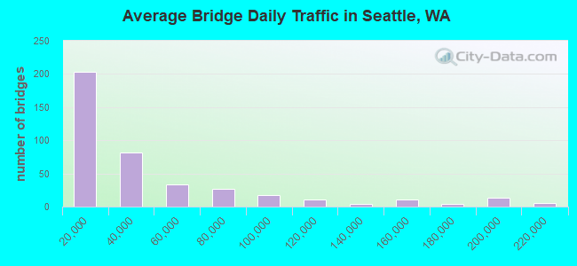
- 16,995,808Total average daily traffic
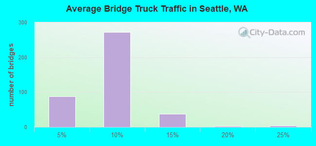
- 1,082,900Total average daily truck traffic
- National Bridge Inventory (NBI) Registered Bridges for Seattle
- No street view available for this location
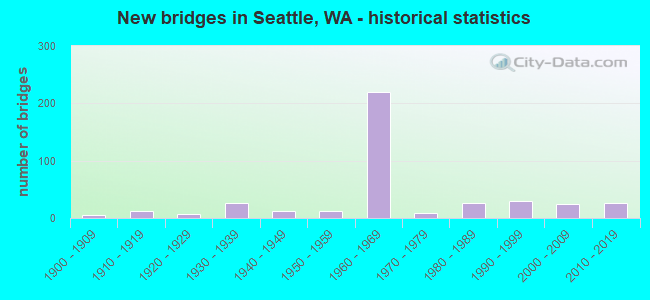
- New bridges - historical statistics
- 61900-1909
- 121910-1919
- 71920-1929
- 261930-1939
- 121940-1949
- 131950-1959
- 2191960-1969
- 91970-1979
- 271980-1989
- 291990-1999
- 252000-2009
- 272010-2019
- 12020-2022
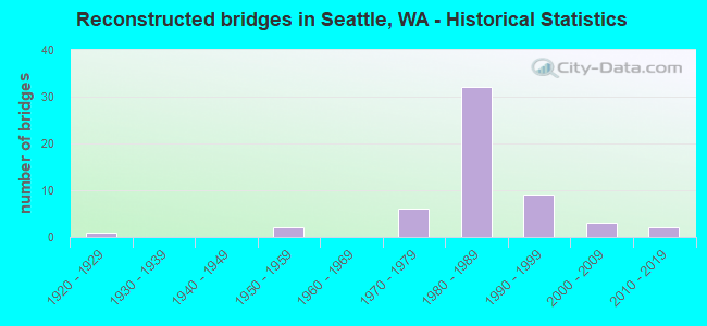
- Reconstructed bridges - Historical Statistics
- 11920-1929
- 01930-1939
- 01940-1949
- 21950-1959
- 01960-1969
- 61970-1979
- 321980-1989
- 91990-1999
- 32000-2009
- 22010-2019
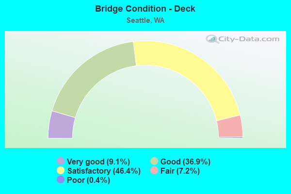
- Bridge Condition - Deck
- 9.1%Very good
- 36.9%Good
- 46.4%Satisfactory
- 7.2%Fair
- 0.4%Poor
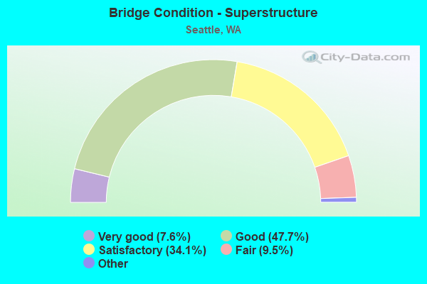
- Bridge Condition - Superstructure
- 7.6%Very good
- 47.7%Good
- 34.1%Satisfactory
- 9.5%Fair
- 1.1%Poor
- 0.4%Critical
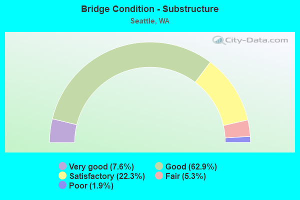
- Bridge Condition - Substructure
- 7.6%Very good
- 62.9%Good
- 22.3%Satisfactory
- 5.3%Fair
- 1.9%Poor
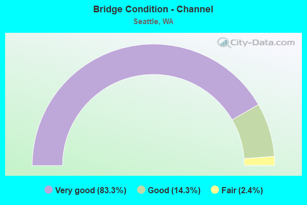
- Bridge Condition - Channel
- 83.3%Very good
- 14.3%Good
- 2.4%Fair
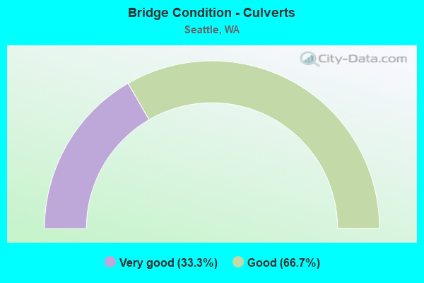
- Bridge Condition - Culverts
- 33.3%Very good
- 66.7%Good
Find on map >> Show street view
Structure Number: 18549B, Location: 5.4 N JCT SR 509 (Lat: 47.623142, Lng: -122.344444), Route carried "on" structure: Ramp State highway 99, Year Built: 2017, Status: Open, Structure Length: 1.77m (5.81ft), Average Daily Traffic: 1,000 (year 2019), Truck Traffic: 5%, Average Future Daily Traffic: 1,486 (year 2039), Design Load: HL 93, Features Intersected: DETENTION VAULT
Minimum Vertical Clearance: 30+ m (98+ ft), Kilometerpoint: 0.016, Lanes on structure: 1, Toll: On toll road, Owner: State Highway Agency, Approaching Roadway Width: 9.4m (30.8ft), Material/Design: Concrete, Design/Construction: Culvert, Number Of Spans In Main Unit: 1, Length of Maximum Span: 16.5m (54.1ft)
Condition: Culverts: Very good, Operating Rating: 59.0 metric tons, Method Used To Determine Operating Rating: Load and Resistance Factor Rating (LRFR) rating reported by rating factor(RF) method using HL-93 loadings, Inventory Rating: 45.4 metric tons, Method Used To Determine Inventory Rating: Load and Resistance Factor Rating (LRFR) rating reported by rating factor(RF) method using HL-93 loadings, Structural Evaluation: Equal to present desirable criteria, Approach Roadway Alignment: Equal to present desirable criteria, Length Of Structure Improvement: 1.77m (5.81ft), Designated Inspection Frequency: Every 24 months, Inspection Date: September 2020, Bridge Improvement Cost: $383,000, Roadway Improvement Cost: $77,000, Total Project Cost: $766,000 ( Estimate for 2014)
Find on map >> Show street view
Structure Number: 18549C, Location: 5.7 N JCT SR 509 (Lat: 47.624433, Lng: -122.343769), Route carried "on" structure: State highway 99, Year Built: 2015, Status: Open, Structure Length: 3.93m (12.89ft), Average Daily Traffic: 31,837 (year 2019), Truck Traffic: 4%, Average Future Daily Traffic: 44,953 (year 2039), Design Load: HL 93, Features Intersected: MERCER ST
Minimum Vertical Clearance: 30+ m (98+ ft), Kilometerpoint: 52.593, Lanes on structure: 7, Lanes under structure: 7, Base Highway Network: Yes, Toll: On toll road, Owner: State Highway Agency, Approaching Roadway Width: 31.4m (103.0ft), Skew: 30 degrees, Material/Design: Prestressed concrete, Design/Construction: Stringer/Multi-beam, Number Of Spans In Main Unit: 1, Length of Maximum Span: 37.8m (124.0ft), Curb or Sidewalk Widths: Left: 3.1m (10.2ft), Right: 3.2m (10.5ft), Curb-To-Curb Width: 31.1m (102.0ft), Out-to-Out Width: 35.8m (117.5ft)
Condition: Deck: Very good, Superstructure: Very good, Substructure: Very good, Operating Rating: 68.0 metric tons, Method Used To Determine Operating Rating: Load and Resistance Factor Rating (LRFR) rating reported by rating factor(RF) method using HL-93 loadings, Inventory Rating: 45.0 metric tons, Method Used To Determine Inventory Rating: Load and Resistance Factor Rating (LRFR) rating reported by rating factor(RF) method using HL-93 loadings, Structural Evaluation: Equal to present desirable criteria, Deck Geometry: Equal to present minimum criteria, Underclear: Equal to present minimum criteria, Approach Roadway Alignment: Equal to present desirable criteria, Length Of Structure Improvement: 3.93m (12.89ft), Designated Inspection Frequency: Every 24 months, Inspection Date: August 2021, Bridge Improvement Cost: $2,709,000, Roadway Improvement Cost: $542,000, Total Project Cost: $5,418,000 ( Estimate for 2014), Deck Structure Type: Concrete Cast-file-Place, Wearing Surface/Protective System: Wearing Surface: Monolithic Concrete, Deck Protection: Epoxy Coated Reinforcing
Find on map >> Show street view
Structure Number: 18625A, Location: 0.7 E JCT SR 513 (Lat: 47.645181, Lng: -122.299294), Route carried "on" structure: State highway 520, Year Built: 2017, Status: Open, Structure Length: 181.90m (596.78ft), Average Daily Traffic: 24,928 (year 2019), Truck Traffic: 3%, Average Future Daily Traffic: 35,198 (year 2039), Design Load: HL 93, Features Intersected: LAKE WASHINGTON
Minimum Vertical Clearance: 30+ m (98+ ft), Kilometerpoint: 1.899, Lanes on structure: 4, Base Highway Network: Yes, Owner: State Highway Agency, Approaching Roadway Width: 15.8m (51.8ft), Skew: 30 degrees, Navigation Control: Yes ( Vertical Clearance: 14.3m (46.9ft), Horizontal Clearance: 43.9m (144.0ft)), Material/Design: Concrete continuous, Design/Construction: Stringer/Multi-beam, Number Of Spans In Main Unit: 41, Number Of Approach Spans: 1, Length of Maximum Span: 48.8m (160.1ft), Curb or Sidewalk Widths: Left: 4.5m (14.8ft), Right: 0.0m, Curb-To-Curb Width: 14.6m (47.9ft), Out-to-Out Width: 23.9m (78.4ft)
Condition: Deck: Good, Superstructure: Very good, Substructure: Very good, Channel: Very good, Operating Rating: 42.8 metric tons, Method Used To Determine Operating Rating: Load and Resistance Factor Rating (LRFR) rating reported by rating factor(RF) method using HL-93 loadings, Inventory Rating: 32.7 metric tons, Method Used To Determine Inventory Rating: Load and Resistance Factor Rating (LRFR) rating reported by rating factor(RF) method using HL-93 loadings, Structural Evaluation: Equal to present desirable criteria, Deck Geometry: High priority of replacement, Waterway Adequacy: Equal to present desirable criteria, Approach Roadway Alignment: Equal to present desirable criteria, Length Of Structure Improvement: 182.21m (597.80ft), Designated Inspection Frequency: Every 24 months, Underwater Inspection Frequency: Every 60 months, Inspection Date: August 2021, Underwater Inspection Date: September 2017, Bridge Improvement Cost: $148,254,000, Roadway Improvement Cost: $29,651,000, Total Project Cost: $296,509,000 ( Estimate for 2014), Deck Structure Type: Concrete Cast-file-Place, Wearing Surface/Protective System: Wearing Surface: Monolithic Concrete, Deck Protection: Epoxy Coated Reinforcing
Find on map >> Show street view
Structure Number: 18625B, Location: 0.1 E JCT SR 513 (Lat: 47.644667, Lng: -122.302056), Route carried "on" structure: City street 520, Year Built: 2017, Status: Open, Structure Length: 2.74m (8.99ft), Average Daily Traffic: 4,752 (year 2009), Truck Traffic: 3%, Average Future Daily Traffic: 6,035 (year 2036), Design Load: HL 93, Features Intersected: SR 520, Facility Carried by Structure: 24TH AVE E
Minimum Vertical Clearance: 30+ m (98+ ft), Kilometerpoint: 0.129, Lanes on structure: 1, Lanes under structure: 4, Owner: State Highway Agency, Approaching Roadway Width: 7.0m (23.0ft), Skew: 1 degrees, Material/Design: Concrete continuous, Design/Construction: Slab, Number Of Spans In Main Unit: 2, Length of Maximum Span: 13.1m (43.0ft), Curb or Sidewalk Widths: Left: 4.9m (16.1ft), Right: 0.0m, Curb-To-Curb Width: 7.0m (23.0ft), Out-to-Out Width: 13.4m (44.0ft)
Condition: Deck: Very good, Superstructure: Very good, Substructure: Very good, Operating Rating: 76.8 metric tons, Method Used To Determine Operating Rating: Load and Resistance Factor Rating (LRFR) rating reported by rating factor(RF) method using HL-93 loadings, Inventory Rating: 59.3 metric tons, Method Used To Determine Inventory Rating: Load and Resistance Factor Rating (LRFR) rating reported by rating factor(RF) method using HL-93 loadings, Structural Evaluation: Equal to present desirable criteria, Deck Geometry: High priority of replacement, Underclear: Meets minimum limits, Approach Roadway Alignment: Equal to present desirable criteria, Length Of Structure Improvement: 2.74m (8.99ft), Designated Inspection Frequency: Every 24 months, Inspection Date: August 2019, Bridge Improvement Cost: $450,000, Roadway Improvement Cost: $90,000, Total Project Cost: $900,000 ( Estimate for 2014), Deck Structure Type: Concrete Cast-file-Place, Wearing Surface/Protective System: Wearing Surface: Monolithic Concrete, Deck Protection: Epoxy Coated Reinforcing
Find on map >> Show street view
Structure Number: 18921A, Location: 4.3 N JCT SR 509 (Lat: 47.593194, Lng: -122.335500), Route carried "on" structure: Ramp State highway 99, Year Built: 2019, Status: Open, Structure Length: 12.19m (39.99ft), Average Daily Traffic: 13,058 (year 2019), Truck Traffic: 5%, Average Future Daily Traffic: 20,000 (year 2040), Design Load: HL 93, Features Intersected: RAMP AND TERRAIN
Minimum Vertical Clearance: 30+ m (98+ ft), Kilometerpoint: 0.322, Lanes on structure: 2, Lanes under structure: 2, Owner: State Highway Agency, Approaching Roadway Width: 9.1m (29.9ft), Material/Design: Concrete continuous, Design/Construction: Channel Beam, Number Of Spans In Main Unit: 3, Length of Maximum Span: 54.9m (180.1ft), Curb-To-Curb Width: 9.3m (30.5ft), Out-to-Out Width: 10.4m (34.1ft)
Condition: Deck: Very good, Superstructure: Very good, Substructure: Very good, Operating Rating: 55.7 metric tons, Method Used To Determine Operating Rating: Load and Resistance Factor Rating (LRFR) rating reported by rating factor(RF) method using HL-93 loadings, Inventory Rating: 35.3 metric tons, Method Used To Determine Inventory Rating: Load and Resistance Factor Rating (LRFR) rating reported by rating factor(RF) method using HL-93 loadings, Structural Evaluation: Equal to present desirable criteria, Deck Geometry: Somewhat better than minimum adequacy, Underclear: High priority of corrective action, Approach Roadway Alignment: Equal to present desirable criteria, Length Of Structure Improvement: 12.19m (39.99ft), Designated Inspection Frequency: Every 24 months, Inspection Date: May 2021, Bridge Improvement Cost: $2,560,000, Roadway Improvement Cost: $512,000, Total Project Cost: $5,120,000 ( Estimate for 2014), Deck Structure Type: Concrete Cast-file-Place, Wearing Surface/Protective System: Deck Protection: Epoxy Coated Reinforcing
Find on map >> Show street view
Structure Number: 19074A, Location: W END YESLER WAY (Lat: 47.602889, Lng: -122.339417), Route carried "on" structure: State highway 519, Year Built: 2019, Status: Open, Structure Length: 19.35m (63.48ft), Average Daily Traffic: 10,212 (year 2010), Truck Traffic: 1%, Average Future Daily Traffic: 12,254 (year 2034), Design Load: HL 93, Features Intersected: PUGET SOUND @ SEATTLE, Facility Carried by Structure: FERRY TRAFFIC
Minimum Vertical Clearance: 4.88m (16.01ft), Kilometerpoint: 0.080, Lanes on structure: 2, Base Highway Network: Yes, Toll: Toll bridge, Owner: State Highway Agency, Approaching Roadway Width: 8.8m (28.9ft), Material/Design: Concrete, Design/Construction: Slab, Number Of Spans In Main Unit: 24, Length of Maximum Span: 10.7m (35.1ft), Curb or Sidewalk Widths: Left: 0.0m, Right: 1.8m (5.9ft), Curb-To-Curb Width: 8.8m (28.9ft), Out-to-Out Width: 11.0m (36.1ft)
Condition: Deck: Very good, Superstructure: Very good, Substructure: Satisfactory, Channel: Very good, Operating Rating: 50.9 metric tons, Method Used To Determine Operating Rating: Load and Resistance Factor Rating (LRFR) rating reported by rating factor(RF) method using HL-93 loadings, Inventory Rating: 39.2 metric tons, Method Used To Determine Inventory Rating: Load and Resistance Factor Rating (LRFR) rating reported by rating factor(RF) method using HL-93 loadings, Structural Evaluation: Equal to present minimum criteria, Deck Geometry: Meets minimum limits, Waterway Adequacy: Equal to present desirable criteria, Approach Roadway Alignment: Equal to present desirable criteria, Length Of Structure Improvement: 19.35m (63.48ft), Designated Inspection Frequency: Every 24 months, Inspection Date: June 2020, Bridge Improvement Cost: $3,937,000, Roadway Improvement Cost: $787,000, Total Project Cost: $7,874,000 ( Estimate for 2014), Deck Structure Type: Concrete Precast Panels, Wearing Surface/Protective System: Wearing Surface: Bituminous, Deck Protection: Epoxy Coated Reinforcing
Find on map >> Show street view
Structure Number: 19074B, Location: W END MARION STREET (Lat: 47.602889, Lng: -122.339417), Route carried "on" structure: State highway 519, Year Built: 2019, Status: Open, Structure Length: 6.31m (20.70ft), Average Daily Traffic: 12,000 (year 2010), Truck Traffic: 1%, Average Future Daily Traffic: 12,254 (year 2034), Design Load: HL 93, Features Intersected: PUGET SOUND @ SEATTLE, Facility Carried by Structure: FERRY TRAFIC
Minimum Vertical Clearance: 4.88m (16.01ft), Kilometerpoint: 0.080, Lanes on structure: 2, Base Highway Network: Yes, Toll: Toll bridge, Owner: State Highway Agency, Approaching Roadway Width: 7.6m (24.9ft), Material/Design: Concrete, Design/Construction: Slab, Number Of Spans In Main Unit: 24, Length of Maximum Span: 7.6m (24.9ft), Curb-To-Curb Width: 6.1m (20.0ft), Out-to-Out Width: 7.3m (24.0ft)
Condition: Deck: Very good, Superstructure: Very good, Substructure: Satisfactory, Channel: Very good, Operating Rating: 43.1 metric tons, Method Used To Determine Operating Rating: Load and Resistance Factor Rating (LRFR) rating reported by rating factor(RF) method using HL-93 loadings, Inventory Rating: 36.0 metric tons, Method Used To Determine Inventory Rating: Load and Resistance Factor Rating (LRFR) rating reported by rating factor(RF) method using HL-93 loadings, Structural Evaluation: Equal to present minimum criteria, Deck Geometry: High priority of replacement, Waterway Adequacy: Equal to present desirable criteria, Approach Roadway Alignment: Equal to present desirable criteria, Length Of Structure Improvement: 6.31m (20.70ft), Designated Inspection Frequency: Every 24 months, Inspection Date: June 2020, Bridge Improvement Cost: $1,118,000, Roadway Improvement Cost: $224,000, Total Project Cost: $2,236,000 ( Estimate for 2014), Deck Structure Type: Concrete Precast Panels, Wearing Surface/Protective System: Wearing Surface: Bituminous, Deck Protection: Epoxy Coated Reinforcing
Find on map >> Show street view
Structure Number: 200411, Location: 2.3 N JCT SR 520 (Lat: 47.678278, Lng: -122.321056), Route carried "on" structure: Interstate 5, Year Built: 1963, Status: Open, Structure Length: 1.74m (5.71ft), Average Daily Traffic: 78,308 (year 2019), Truck Traffic: 5%, Average Future Daily Traffic: 110,570 (year 2039), Features Intersected: FALLOUT SHELTER
Minimum Vertical Clearance: 30+ m (98+ ft), Kilometerpoint: 274.506, Lanes on structure: 4, Base Highway Network: Yes, Owner: State Highway Agency, Approaching Roadway Width: 18.9m (62.0ft), Material/Design: Concrete, Design/Construction: Culvert, Number Of Spans In Main Unit: 1, Length of Maximum Span: 17.4m (57.1ft), Curb-To-Curb Width: 18.9m (62.0ft), Out-to-Out Width: 18.9m (62.0ft)
Condition: Culverts: Good, Operating Rating: 54.4 metric tons, Method Used To Determine Operating Rating: Field evaluation and documented engineering judgment, Inventory Rating: 32.7 metric tons, Method Used To Determine Inventory Rating: Field evaluation and documented engineering judgment, Structural Evaluation: Better than present minimum criteria, Deck Geometry: Meets minimum limits, Approach Roadway Alignment: Equal to present desirable criteria, Length Of Structure Improvement: 1.74m (5.71ft), Designated Inspection Frequency: Every 48 months, Inspection Date: September 2018, Bridge Improvement Cost: $730,000, Roadway Improvement Cost: $146,000, Total Project Cost: $1,459,000 ( Estimate for 2014)
Find on map >> Show street view
Structure Number: 85041, Location: Seattle Blvd EO 4th Ave S (Lat: 47.596111, Lng: -122.328333), Route carried "on" structure: City street 1140, Year Built: 1910, Year Reconstructed: 1981, Status: Open, Structure Length: 8.75m (28.71ft), Average Daily Traffic: 22,000 (year 2019), Truck Traffic: 5%, Average Future Daily Traffic: 28,000 (year 2039), Design Load: HS 25 or greater, Features Intersected: SOUND TRANSIT TUNNEL, Facility Carried by Structure: SEATTLE BLVD
Minimum Vertical Clearance: 30+ m (98+ ft), Kilometerpoint: 0.001, Lanes on structure: 6, Base Highway Network: Yes, Owner: City or Municipal Highway Agency, Approaching Roadway Width: 20.7m (67.9ft), Skew: 33 degrees, Material/Design: Steel, Design/Construction: Girder and Floorbeam System, Number Of Spans In Main Unit: 3, Number Of Approach Spans: 4, Length of Maximum Span: 22.9m (75.1ft), Curb or Sidewalk Widths: Left: 4.9m (16.1ft), Right: 4.9m (16.1ft), Curb-To-Curb Width: 20.7m (67.9ft), Out-to-Out Width: 30.8m (101.0ft)
Condition: Deck: Satisfactory, Superstructure: Satisfactory, Substructure: Satisfactory, Operating Rating: 42.6 metric tons, Method Used To Determine Operating Rating: Load Factor (LF), Inventory Rating: 25.4 metric tons, Method Used To Determine Inventory Rating: Load Factor (LF), Structural Evaluation: Equal to present minimum criteria, Deck Geometry: High priority of replacement, Underclear: High priority of replacement, Approach Roadway Alignment: Equal to present desirable criteria, Length Of Structure Improvement: 8.75m (28.71ft), Designated Inspection Frequency: Every 24 months, Inspection Date: August 2021, Bridge Improvement Cost: $1,269,000, Roadway Improvement Cost: $1,000, Total Project Cost: $1,898,000, Deck Structure Type: Concrete Cast-file-Place, Wearing Surface/Protective System: Wearing Surface: Bituminous
Find on map >> Show street view
Structure Number: 85042, Location: 12th Ave S & Dearborn St (Lat: 47.595833, Lng: -122.317222), Route carried "on" structure: City street 1140, Year Built: 1917, Status: Open, Structure Length: 15.09m (49.51ft), Average Daily Traffic: 22,000 (year 2020), Truck Traffic: 5%, Average Future Daily Traffic: 24,000 (year 2040), Features Intersected: DEARBORN ST, Facility Carried by Structure: 12 AVE S
Minimum Vertical Clearance: 30+ m (98+ ft), Kilometerpoint: 0.001, Lanes on structure: 4, Lanes under structure: 5, Owner: City or Municipal Highway Agency, Approaching Roadway Width: 12.8m (42.0ft), Material/Design: Steel continuous, Design/Construction: Truss - Deck, Number Of Spans In Main Unit: 3, Number Of Approach Spans: 3, Length of Maximum Span: 52.1m (170.9ft), Curb or Sidewalk Widths: Left: 3.2m (10.5ft), Right: 3.2m (10.5ft), Curb-To-Curb Width: 12.8m (42.0ft), Out-to-Out Width: 19.8m (65.0ft)
Condition: Deck: Fair, Superstructure: Satisfactory, Substructure: Satisfactory, Operating Rating: 43.5 metric tons, Method Used To Determine Operating Rating: Load Factor (LF), Inventory Rating: 25.4 metric tons, Method Used To Determine Inventory Rating: Load Factor (LF), Structural Evaluation: Equal to present minimum criteria, Deck Geometry: High priority of replacement, Underclear: Superior to present desirable criteria, Approach Roadway Alignment: Equal to present minimum criteria, Length Of Structure Improvement: 13.90m (45.60ft), Designated Inspection Frequency: Every 24 months, Inspection Date: June 2021, Bridge Improvement Cost: $14,820,000, Roadway Improvement Cost: $14,820,000, Total Project Cost: $29,640,000 ( Estimate for 2019), Deck Structure Type: Concrete Cast-file-Place, Wearing Surface/Protective System: Wearing Surface: Monolithic Concrete
Find on map >> Show street view
Structure Number: 85047, Location: 4th Ave S & Yesler Way (Lat: 47.601667, Lng: -122.328889), Route carried "on" structure: City street 1140, Year Built: 1909, Year Reconstructed: 2017, Status: Open, Structure Length: 2.50m (8.20ft), Average Daily Traffic: 8,000 (year 2018), Truck Traffic: 5%, Average Future Daily Traffic: 9,000 (year 2038), Design Load: HL 93, Features Intersected: 4TH AVE S, Facility Carried by Structure: YESLER WAY
Minimum Vertical Clearance: 30+ m (98+ ft), Kilometerpoint: 0.001, Lanes on structure: 3, Lanes under structure: 4, Owner: City or Municipal Highway Agency, Approaching Roadway Width: 12.8m (42.0ft), Skew: 9 degrees, Material/Design: Steel, Design/Construction: Girder and Floorbeam System, Number Of Spans In Main Unit: 1, Length of Maximum Span: 25.0m (82.0ft), Curb or Sidewalk Widths: Left: 6.9m (22.6ft), Right: 3.7m (12.1ft), Curb-To-Curb Width: 12.8m (42.0ft), Out-to-Out Width: 23.3m (76.4ft)
Condition: Deck: Very good, Superstructure: Very good, Substructure: Very good, Operating Rating: 42.8 metric tons, Method Used To Determine Operating Rating: Load and Resistance Factor Rating (LRFR) rating reported by rating factor(RF) method using HL-93 loadings, Inventory Rating: 33.0 metric tons, Method Used To Determine Inventory Rating: Load and Resistance Factor Rating (LRFR) rating reported by rating factor(RF) method using HL-93 loadings, Structural Evaluation: Equal to present desirable criteria, Deck Geometry: Meets minimum limits, Underclear: High priority of corrective action, Approach Roadway Alignment: Equal to present desirable criteria, Length Of Structure Improvement: 2.50m (8.20ft), Designated Inspection Frequency: Every 24 months, Inspection Date: June 2021, Bridge Improvement Cost: $722,000, Roadway Improvement Cost: $144,000, Total Project Cost: $1,443,000 ( Estimate for 2014), Deck Structure Type: Concrete Cast-file-Place, Wearing Surface/Protective System: Deck Protection: Epoxy Coated Reinforcing
Find on map >> Show street view
Structure Number: 85048, Location: S Jackson St EO 4th Ave S (Lat: 47.599197, Lng: -122.328608), Route carried "on" structure: City street 1140, Year Built: 1910, Status: Open, Structure Length: 4.36m (14.30ft), Average Daily Traffic: 15,000 (year 2020), Truck Traffic: 5%, Average Future Daily Traffic: 20,000 (year 2043), Design Load: HS 25 or greater, Features Intersected: Parking garage, Facility Carried by Structure: S JACKSON ST
Minimum Vertical Clearance: 30+ m (98+ ft), Kilometerpoint: 0.001, Lanes on structure: 4, Owner: City or Municipal Highway Agency, Approaching Roadway Width: 16.8m (55.1ft), Material/Design: Concrete continuous, Design/Construction: Stringer/Multi-beam, Number Of Spans In Main Unit: 7, Length of Maximum Span: 7.0m (23.0ft), Curb or Sidewalk Widths: Left: 4.9m (16.1ft), Right: 5.5m (18.0ft), Curb-To-Curb Width: 16.9m (55.4ft), Out-to-Out Width: 27.4m (89.9ft)
Condition: Deck: Fair, Superstructure: Fair, Substructure: Satisfactory, Operating Rating: 50.8 metric tons, Method Used To Determine Operating Rating: Load Factor (LF), Inventory Rating: 29.9 metric tons, Method Used To Determine Inventory Rating: Load Factor (LF), Structural Evaluation: Somewhat better than minimum adequacy, Deck Geometry: Somewhat better than minimum adequacy, Approach Roadway Alignment: Equal to present desirable criteria, Length Of Structure Improvement: 4.36m (14.30ft), Designated Inspection Frequency: Every 24 months, Inspection Date: August 2021, Bridge Improvement Cost: $1,630,000, Roadway Improvement Cost: $326,000, Total Project Cost: $3,260,000 ( Estimate for 2014), Deck Structure Type: Concrete Cast-file-Place, Wearing Surface/Protective System: Wearing Surface: Epoxy Overlay
Find on map >> Show street view
Structure Number: 85049, Location: 5th Ave S & Yesler Way (Lat: 47.601667, Lng: -122.327778), Route carried "on" structure: City street 1140, Year Built: 1912, Year Reconstructed: 1977, Status: Open, Structure Length: 2.10m (6.89ft), Average Daily Traffic: 7,215 (year 2021), Truck Traffic: 5%, Average Future Daily Traffic: 8,802 (year 2040), Design Load: HS 20, Features Intersected: 5TH AVE S, Facility Carried by Structure: YESLER WAY
Minimum Vertical Clearance: 30+ m (98+ ft), Kilometerpoint: 0.001, Lanes on structure: 2, Lanes under structure: 3, Owner: City or Municipal Highway Agency, Approaching Roadway Width: 12.8m (42.0ft), Material/Design: Steel, Design/Construction: Girder and Floorbeam System, Number Of Spans In Main Unit: 1, Length of Maximum Span: 21.0m (68.9ft), Curb or Sidewalk Widths: Left: 3.6m (11.8ft), Right: 3.6m (11.8ft), Curb-To-Curb Width: 12.8m (42.0ft), Out-to-Out Width: 20.1m (65.9ft)
Condition: Deck: Satisfactory, Superstructure: Satisfactory, Substructure: Satisfactory, Operating Rating: 74.4 metric tons, Method Used To Determine Operating Rating: Load Factor (LF), Inventory Rating: 44.4 metric tons, Method Used To Determine Inventory Rating: Load Factor (LF), Structural Evaluation: Equal to present minimum criteria, Deck Geometry: Somewhat better than minimum adequacy, Underclear: Somewhat better than minimum adequacy, Approach Roadway Alignment: Equal to present desirable criteria, Length Of Structure Improvement: 2.41m (7.91ft), Designated Inspection Frequency: Every 24 months, Inspection Date: June 2021, Bridge Improvement Cost: $1,201,000, Roadway Improvement Cost: $240,000, Total Project Cost: $2,402,000 ( Estimate for 2014), Deck Structure Type: Concrete Cast-file-Place
Find on map >> Show street view
Structure Number: 8505, Location: 4th Ave S & Jackson St (Lat: 47.597500, Lng: -122.329167), Route carried "on" structure: City street 1140, Year Built: 1910, Year Reconstructed: 1981, Status: Open, Structure Length: 35.91m (117.81ft), Average Daily Traffic: 13,500 (year 2019), Truck Traffic: 5%, Average Future Daily Traffic: 16,470 (year 2039), Design Load: H 20, Features Intersected: RAILROAD STATION, Facility Carried by Structure: 4TH AVE S
Minimum Vertical Clearance: 30+ m (98+ ft), Kilometerpoint: 0.001, Lanes on structure: 3, Base Highway Network: Yes, Owner: City or Municipal Highway Agency, Approaching Roadway Width: 8.5m (27.9ft), Material/Design: Concrete continuous, Design/Construction: Slab, Number Of Spans In Main Unit: 67, Length of Maximum Span: 9.4m (30.8ft), Curb or Sidewalk Widths: Left: 4.7m (15.4ft), Right: 0.0m, Curb-To-Curb Width: 8.8m (28.9ft), Out-to-Out Width: 13.7m (44.9ft)
Condition: Deck: Fair, Superstructure: Satisfactory, Substructure: Satisfactory, Operating Rating: 43.5 metric tons, Method Used To Determine Operating Rating: Load Testing, Inventory Rating: 26.3 metric tons, Method Used To Determine Inventory Rating: Load Testing, Structural Evaluation: Equal to present minimum criteria, Deck Geometry: High priority of replacement, Approach Roadway Alignment: Equal to present desirable criteria, Length Of Structure Improvement: 35.91m (117.81ft), Designated Inspection Frequency: Every 24 months, Inspection Date: August 2021, Bridge Improvement Cost: $7,068,000, Roadway Improvement Cost: $1,414,000, Total Project Cost: $14,136,000 ( Estimate for 2014), Deck Structure Type: Concrete Cast-file-Place, Wearing Surface/Protective System: Wearing Surface: Latex Concrete
Find on map >> Show street view
Structure Number: 85051, Location: 2nd Ave S & Jackson (Lat: 47.599167, Lng: -122.329444), Route carried "on" structure: City street 1140, Year Built: 1928, Status: Open, Structure Length: 6.34m (20.80ft), Average Daily Traffic: 13,700 (year 2019), Truck Traffic: 5%, Average Future Daily Traffic: 16,714 (year 2039), Design Load: HS 20, Features Intersected: RAILROAD, Facility Carried by Structure: 2 AVE EXTEN S
Minimum Vertical Clearance: 30+ m (98+ ft), Kilometerpoint: 0.001, Lanes on structure: 4, Base Highway Network: Yes, Owner: City or Municipal Highway Agency, Approaching Roadway Width: 15.2m (49.9ft), Skew: 3 degrees, Material/Design: Concrete continuous, Design/Construction: Slab, Number Of Spans In Main Unit: 7, Length of Maximum Span: 10.4m (34.1ft), Curb or Sidewalk Widths: Left: 2.4m (7.9ft), Right: 2.7m (8.9ft), Curb-To-Curb Width: 15.2m (49.9ft), Out-to-Out Width: 24.1m (79.1ft)
Condition: Deck: Poor, Superstructure: Poor, Substructure: Fair, Operating Rating: 89.8 metric tons, Method Used To Determine Operating Rating: Field evaluation and documented engineering judgment, Inventory Rating: 89.8 metric tons, Method Used To Determine Inventory Rating: Field evaluation and documented engineering judgment, Structural Evaluation: Meets minimum limits, Deck Geometry: High priority of corrective action, Underclear: High priority of corrective action, Approach Roadway Alignment: Equal to present minimum criteria, Length Of Structure Improvement: 6.34m (20.80ft), Designated Inspection Frequency: Every 24 months, Critical Feature Inspection Frequency: Every 24 months, Inspection Date: August 2021, Critical Feature Inspection Date: August 2021, Bridge Improvement Cost: $705,000, Roadway Improvement Cost: $1,000, Total Project Cost: $932,000, Deck Structure Type: Concrete Cast-file-Place, Wearing Surface/Protective System: Wearing Surface: Monolithic Concrete
Find on map >> Show street view
Structure Number: 85053, Location: 5th Ave S SO S Jackson St (Lat: 47.597778, Lng: -122.327778), Route carried "on" structure: City street 1140, Year Built: 1910, Year Reconstructed: 1987, Status: Open, Structure Length: 28.65m (94.00ft), Average Daily Traffic: 8,000 (year 2020), Truck Traffic: 5%, Average Future Daily Traffic: 9,000 (year 2043), Features Intersected: ST TUNNEL, Facility Carried by Structure: 5TH AVE S
Minimum Vertical Clearance: 30+ m (98+ ft), Kilometerpoint: 0.001, Lanes on structure: 2, Owner: Local Agency, Approaching Roadway Width: 12.2m (40.0ft), Material/Design: Concrete, Design/Construction: Slab, Number Of Spans In Main Unit: 38, Length of Maximum Span: 9.1m (29.9ft), Curb or Sidewalk Widths: Left: 4.0m (13.1ft), Right: 0.0m, Curb-To-Curb Width: 12.2m (40.0ft), Out-to-Out Width: 4.9m (16.1ft)
Condition: Deck: Satisfactory, Superstructure: Satisfactory, Substructure: Satisfactory, Operating Rating: 48.1 metric tons, Method Used To Determine Operating Rating: Load and Resistance Factor (LRFR), Inventory Rating: 29.0 metric tons, Method Used To Determine Inventory Rating: Load and Resistance Factor (LRFR), Structural Evaluation: Equal to present minimum criteria, Deck Geometry: Somewhat better than minimum adequacy, Approach Roadway Alignment: Equal to present desirable criteria, Length Of Structure Improvement: 28.65m (94.00ft), Designated Inspection Frequency: Every 24 months, Inspection Date: July 2021, Bridge Improvement Cost: $7,896,000, Roadway Improvement Cost: $1,579,000, Total Project Cost: $15,792,000 ( Estimate for 2014), Deck Structure Type: Concrete Cast-file-Place, Wearing Surface/Protective System: Wearing Surface: Bituminous
Find on map >> Show street view
Structure Number: 85056, Location: S Main St, 3rd - 4th Ave (Lat: 47.600000, Lng: -122.329444), Route carried "on" structure: City street 1140, Year Built: 1982, Status: Open, Structure Length: 3.96m (12.99ft), Average Daily Traffic: 2,300 (year 2017), Truck Traffic: 10%, Average Future Daily Traffic: 3,500 (year 2043), Design Load: HS 20, Features Intersected: RR, Facility Carried by Structure: S MAIN ST
Minimum Vertical Clearance: 30+ m (98+ ft), Kilometerpoint: 0.001, Lanes on structure: 4, Owner: City or Municipal Highway Agency, Approaching Roadway Width: 12.8m (42.0ft), Skew: 9 degrees, Material/Design: Prestressed concrete, Design/Construction: Stringer/Multi-beam, Number Of Spans In Main Unit: 2, Number Of Approach Spans: 2, Length of Maximum Span: 23.2m (76.1ft), Curb or Sidewalk Widths: Left: 2.4m (7.9ft), Right: 2.4m (7.9ft), Curb-To-Curb Width: 12.8m (42.0ft), Out-to-Out Width: 20.1m (65.9ft)
Condition: Deck: Satisfactory, Superstructure: Good, Substructure: Good, Operating Rating: 51.7 metric tons, Method Used To Determine Operating Rating: Load Factor (LF), Inventory Rating: 6.3 metric tons, Method Used To Determine Inventory Rating: Load Factor (LF), Structural Evaluation: High priority of corrective action, Deck Geometry: High priority of replacement, Underclear: Meets minimum limits, Approach Roadway Alignment: Equal to present desirable criteria, Length Of Structure Improvement: 3.96m (12.99ft), Designated Inspection Frequency: Every 24 months, Inspection Date: August 2021, Bridge Improvement Cost: $1,144,000, Roadway Improvement Cost: $229,000, Total Project Cost: $2,288,000 ( Estimate for 2014), Deck Structure Type: Concrete Cast-file-Place, Wearing Surface/Protective System: Deck Protection: Epoxy Coated Reinforcing
Find on map >> Show street view
Structure Number: 85085, Location: 5700 Phinney Ave N (Lat: 47.670556, Lng: -122.354444), Route carried "on" structure: City street 1140, Year Built: 1900, Status: Open, Structure Length: 1.83m (6.00ft), Average Daily Traffic: 12,400 (year 2019), Truck Traffic: 5%, Average Future Daily Traffic: 14,500 (year 2043), Design Load: HS 15, Features Intersected: N 57TH ST, Facility Carried by Structure: PHINNEY AVE
Minimum Vertical Clearance: 30+ m (98+ ft), Kilometerpoint: 38.624, Lanes on structure: 4, Lanes under structure: 2, Owner: City or Municipal Highway Agency, Approaching Roadway Width: 16.5m (54.1ft), Material/Design: Concrete, Design/Construction: Tee Beam, Number Of Spans In Main Unit: 1, Length of Maximum Span: 18.3m (60.0ft), Curb or Sidewalk Widths: Left: 3.9m (12.8ft), Right: 3.9m (12.8ft), Curb-To-Curb Width: 16.5m (54.1ft), Out-to-Out Width: 26.2m (86.0ft)
Condition: Deck: Good, Superstructure: Satisfactory, Substructure: Good, Operating Rating: 48.1 metric tons, Method Used To Determine Operating Rating: Load and Resistance Factor (LRFR), Inventory Rating: 37.2 metric tons, Method Used To Determine Inventory Rating: Load and Resistance Factor (LRFR), Structural Evaluation: Equal to present minimum criteria, Deck Geometry: Meets minimum limits, Underclear: High priority of corrective action, Approach Roadway Alignment: Equal to present desirable criteria, Length Of Structure Improvement: 1.83m (6.00ft), Designated Inspection Frequency: Every 24 months, Inspection Date: June 2021, Bridge Improvement Cost: $2,064,000, Roadway Improvement Cost: $516,000, Total Project Cost: $2,580,000 ( Estimate for 2031), Deck Structure Type: Concrete Cast-file-Place, Wearing Surface/Protective System: Wearing Surface: Bituminous
Find on map >> Show street view
Structure Number: 85117, Location: 15th Ave NE & NE 62nd St (Lat: 47.673333, Lng: -122.311944), Route carried "on" structure: City street 1140, Year Built: 1936, Status: Posted for load, Structure Length: 10.91m (35.79ft), Average Daily Traffic: 12,100 (year 2018), Truck Traffic: 5%, Average Future Daily Traffic: 16,000 (year 2038), Design Load: H 20, Features Intersected: COWEN PARK, RAVINE, Facility Carried by Structure: 15th Ave NE
Minimum Vertical Clearance: 30+ m (98+ ft), Kilometerpoint: 0.001, Lanes on structure: 2, Owner: City or Municipal Highway Agency, Approaching Roadway Width: 12.8m (42.0ft), Material/Design: Concrete continuous, Design/Construction: Arch - Deck, Number Of Spans In Main Unit: 1, Number Of Approach Spans: 6, Length of Maximum Span: 48.8m (160.1ft), Curb or Sidewalk Widths: Left: 1.6m (5.2ft), Right: 1.6m (5.2ft), Curb-To-Curb Width: 12.8m (42.0ft), Out-to-Out Width: 16.9m (55.4ft)
Condition: Deck: Fair, Superstructure: Fair, Substructure: Satisfactory, Channel: Very good, Operating Rating: 32.7 metric tons, Method Used To Determine Operating Rating: Load Testing, Inventory Rating: 32.7 metric tons, Method Used To Determine Inventory Rating: Load Testing, Structural Evaluation: Somewhat better than minimum adequacy, Deck Geometry: Somewhat better than minimum adequacy, Waterway Adequacy: Equal to present desirable criteria, Approach Roadway Alignment: Equal to present desirable criteria, Bridge Posting: Required (Relationship of Operating Rating to Maximum Legal Load: 0.1 - 9.9% below), Length Of Structure Improvement: 10.91m (35.79ft), Designated Inspection Frequency: Every 24 months, Inspection Date: April 2020, Bridge Improvement Cost: $3,150,000, Roadway Improvement Cost: $630,000, Total Project Cost: $6,301,000 ( Estimate for 2014), Deck Structure Type: Concrete Cast-file-Place, Wearing Surface/Protective System: Wearing Surface: Bituminous, Membrane: Built-up
Find on map >> Show street view
Structure Number: 8513, Location: NE 45th St & 25th Ave NE (Lat: 47.661111, Lng: -122.301111), Route carried "on" structure: City street 1140, Year Built: 1938, Year Reconstructed: 1956, Status: Open, Structure Length: 22.25m (73.00ft), Average Daily Traffic: 18,000 (year 2018), Truck Traffic: 5%, Average Future Daily Traffic: 31,600 (year 2038), Design Load: H 15, Features Intersected: 25TH AVE NE, Facility Carried by Structure: NE 45TH ST
Minimum Vertical Clearance: 30+ m (98+ ft), Kilometerpoint: 151.600, Lanes on structure: 3, Lanes under structure: 4, Base Highway Network: Yes, Owner: City or Municipal Highway Agency, Approaching Roadway Width: 11.0m (36.1ft), Skew: 9 degrees, Material/Design: Concrete continuous, Design/Construction: Box Beam or Girders - Multiple, Number Of Spans In Main Unit: 9, Number Of Approach Spans: 2, Length of Maximum Span: 30.5m (100.1ft), Curb or Sidewalk Widths: Left: 0.0m, Right: 1.5m (4.9ft), Curb-To-Curb Width: 11.0m (36.1ft), Out-to-Out Width: 13.6m (44.6ft)
Condition: Deck: Satisfactory, Superstructure: Satisfactory, Substructure: Satisfactory, Operating Rating: 70.7 metric tons, Method Used To Determine Operating Rating: Load Factor (LF), Inventory Rating: 42.6 metric tons, Method Used To Determine Inventory Rating: Load Factor (LF), Structural Evaluation: Equal to present minimum criteria, Deck Geometry: High priority of replacement, Underclear: Equal to present minimum criteria, Approach Roadway Alignment: Equal to present minimum criteria, Length Of Structure Improvement: 22.25m (73.00ft), Designated Inspection Frequency: Every 24 months, Inspection Date: March 2020, Bridge Improvement Cost: $16,425,000, Roadway Improvement Cost: $16,425,000, Total Project Cost: $32,850,000 ( Estimate for 2020), Deck Structure Type: Concrete Cast-file-Place, Wearing Surface/Protective System: Wearing Surface: Monolithic Concrete
Find on map >> Show street view
Structure Number: 85131, Location: NE 45th St & 25th Ave NE (Lat: 47.661242, Lng: -122.299431), Route carried "on" structure: City street 1140, Year Built: 1976, Status: Open, Structure Length: 8.60m (28.22ft), Average Daily Traffic: 25,001 (year 2018), Truck Traffic: 5%, Average Future Daily Traffic: 31,600 (year 2038), Design Load: HS 20, Features Intersected: 25TH AVE NE, Facility Carried by Structure: NE 45TH ST
Minimum Vertical Clearance: 30+ m (98+ ft), Kilometerpoint: 151.439, Lanes on structure: 3, Base Highway Network: Yes, Owner: City or Municipal Highway Agency, Approaching Roadway Width: 11.0m (36.1ft), Skew: 20 degrees, Material/Design: Concrete continuous, Design/Construction: Box Beam or Girders - Multiple, Number Of Spans In Main Unit: 7, Length of Maximum Span: 13.7m (44.9ft), Curb or Sidewalk Widths: Left: 0.0m, Right: 1.5m (4.9ft), Curb-To-Curb Width: 11.0m (36.1ft), Out-to-Out Width: 13.7m (44.9ft)
Condition: Deck: Good, Superstructure: Good, Substructure: Good, Operating Rating: 38.1 metric tons, Method Used To Determine Operating Rating: Load and Resistance Factor (LRFR), Inventory Rating: 22.7 metric tons, Method Used To Determine Inventory Rating: Load and Resistance Factor (LRFR), Structural Evaluation: Somewhat better than minimum adequacy, Deck Geometry: High priority of replacement, Approach Roadway Alignment: Equal to present minimum criteria, Length Of Structure Improvement: 8.60m (28.22ft), Designated Inspection Frequency: Every 24 months, Inspection Date: March 2020, Bridge Improvement Cost: $740,000, Roadway Improvement Cost: $670,000, Total Project Cost: $1,410,000 ( Estimate for 2020), Deck Structure Type: Concrete Cast-file-Place, Wearing Surface/Protective System: Wearing Surface: Monolithic Concrete
Find on map >> Show street view
Structure Number: 85143, Location: 5500 SW Admiral Way (Lat: 47.577222, Lng: -122.403333), Route carried "on" structure: City street 1140, Year Built: 1935, Status: Open, Structure Length: 5.33m (17.49ft), Average Daily Traffic: 12,500 (year 2021), Truck Traffic: 3%, Average Future Daily Traffic: 15,000 (year 2040), Features Intersected: SCHMITZ BLVD, RAVINE, Facility Carried by Structure: SW ADMIRAL WAY
Minimum Vertical Clearance: 30+ m (98+ ft), Kilometerpoint: 0.001, Lanes on structure: 2, Owner: City or Municipal Highway Agency, Approaching Roadway Width: 16.5m (54.1ft), Material/Design: Concrete, Design/Construction: Box Beam or Girders - Multiple, Number Of Spans In Main Unit: 1, Length of Maximum Span: 53.3m (174.9ft), Curb or Sidewalk Widths: Left: 1.8m (5.9ft), Right: 1.8m (5.9ft), Curb-To-Curb Width: 16.5m (54.1ft), Out-to-Out Width: 21.2m (69.6ft)
Condition: Deck: Fair, Superstructure: Satisfactory, Substructure: Satisfactory, Channel: Good, Operating Rating: 69.8 metric tons, Method Used To Determine Operating Rating: Load Factor (LF), Inventory Rating: 41.7 metric tons, Method Used To Determine Inventory Rating: Load Factor (LF), Structural Evaluation: Equal to present minimum criteria, Deck Geometry: Superior to present desirable criteria, Waterway Adequacy: Equal to present desirable criteria, Approach Roadway Alignment: Equal to present desirable criteria, Length Of Structure Improvement: 5.64m (18.50ft), Designated Inspection Frequency: Every 24 months, Inspection Date: August 2021, Bridge Improvement Cost: $2,812,000, Roadway Improvement Cost: $562,000, Total Project Cost: $5,624,000 ( Estimate for 2014), Deck Structure Type: Concrete Cast-file-Place, Wearing Surface/Protective System: Wearing Surface: Monolithic Concrete
Find on map >> Show street view
Structure Number: 85148, Location: NW 57th Pl & NW 57th St (Lat: 47.670556, Lng: -122.403611), Route carried "on" structure: City street 1140, Year Built: 1986, Status: Open, Structure Length: 3.51m (11.52ft), Average Daily Traffic: 730 (year 2019), Truck Traffic: 5%, Average Future Daily Traffic: 830 (year 2039), Design Load: HS 20, Features Intersected: RR TRACK, Facility Carried by Structure: NW 57TH ST
Minimum Vertical Clearance: 30+ m (98+ ft), Kilometerpoint: 0.001, Lanes on structure: 2, Owner: City or Municipal Highway Agency, Approaching Roadway Width: 7.6m (24.9ft), Skew: 3 degrees, Material/Design: Prestressed concrete, Design/Construction: Box Beam or Girders - Multiple, Number Of Spans In Main Unit: 3, Length of Maximum Span: 16.5m (54.1ft), Curb or Sidewalk Widths: Left: 0.0m, Right: 2.4m (7.9ft), Curb-To-Curb Width: 8.5m (27.9ft), Out-to-Out Width: 11.7m (38.4ft)
Condition: Deck: Good, Superstructure: Good, Substructure: Good, Operating Rating: 39.0 metric tons, Method Used To Determine Operating Rating: Load Factor (LF), Inventory Rating: 20.9 metric tons, Method Used To Determine Inventory Rating: Load Factor (LF), Structural Evaluation: Somewhat better than minimum adequacy, Deck Geometry: Somewhat better than minimum adequacy, Underclear: Better than present minimum criteria, Approach Roadway Alignment: Equal to present minimum criteria, Length Of Structure Improvement: 3.81m (12.50ft), Designated Inspection Frequency: Every 24 months, Inspection Date: June 2021, Bridge Improvement Cost: $1,900,000, Roadway Improvement Cost: $380,000, Total Project Cost: $3,800,000 ( Estimate for 2014), Deck Structure Type: Concrete Cast-file-Place
Find on map >> Show street view
Structure Number: 85166, Location: Fairmount Ave SW (Lat: 47.581111, Lng: -122.382222), Route carried "on" structure: City street 1140, Year Built: 1949, Status: Open, Structure Length: 9.08m (29.79ft), Average Daily Traffic: 32,000 (year 2020), Truck Traffic: 5%, Average Future Daily Traffic: 48,000 (year 2040), Design Load: H 20, Features Intersected: RAVINE, FAIRMOUNT AVE, Facility Carried by Structure: SW ADMIRAL WAY
Minimum Vertical Clearance: 30+ m (98+ ft), Kilometerpoint: 27.681, Lanes on structure: 2, Lanes under structure: 2, Base Highway Network: Yes, Owner: City or Municipal Highway Agency, Approaching Roadway Width: 8.5m (27.9ft), Material/Design: Steel, Design/Construction: Stringer/Multi-beam, Number Of Spans In Main Unit: 5, Length of Maximum Span: 25.6m (84.0ft), Curb or Sidewalk Widths: Left: 0.0m, Right: 1.5m (4.9ft), Curb-To-Curb Width: 8.5m (27.9ft), Out-to-Out Width: 10.4m (34.1ft)
Condition: Deck: Good, Superstructure: Good, Substructure: Good, Operating Rating: 49.0 metric tons, Method Used To Determine Operating Rating: Load Testing, Inventory Rating: 38.1 metric tons, Method Used To Determine Inventory Rating: Load Testing, Structural Evaluation: Better than present minimum criteria, Deck Geometry: High priority of corrective action, Underclear: Superior to present desirable criteria, Approach Roadway Alignment: Equal to present desirable criteria, Length Of Structure Improvement: 9.08m (29.79ft), Designated Inspection Frequency: Every 24 months, Inspection Date: April 2020, Bridge Improvement Cost: $429,000, Roadway Improvement Cost: $42,000, Total Project Cost: $644,000 ( Estimate for 2018), Deck Structure Type: Concrete Cast-file-Place, Wearing Surface/Protective System: Wearing Surface: Bituminous
Find on map >> Show street view
Structure Number: 85167, Location: 4001 SW ADMIRAL WAY (Lat: 47.581197, Lng: -122.382258), Route carried "on" structure: City street 1140, Year Built: 1927, Status: Open, Structure Length: 8.84m (29.00ft), Average Daily Traffic: 31,000 (year 2020), Truck Traffic: 5%, Average Future Daily Traffic: 45,000 (year 2040), Design Load: HS 20, Features Intersected: RAVINE, FAIRMOUNT AVE, Facility Carried by Structure: SW ADMIRAL WAY
Minimum Vertical Clearance: 30+ m (98+ ft), Kilometerpoint: 27.520, Lanes on structure: 2, Lanes under structure: 2, Base Highway Network: Yes, Owner: City or Municipal Highway Agency, Approaching Roadway Width: 7.9m (25.9ft), Material/Design: Concrete continuous, Design/Construction: Truss - Deck, Number Of Spans In Main Unit: 1, Number Of Approach Spans: 6, Length of Maximum Span: 24.4m (80.1ft), Curb or Sidewalk Widths: Left: 1.7m (5.6ft), Right: 0.0m, Curb-To-Curb Width: 7.2m (23.6ft), Out-to-Out Width: 9.8m (32.2ft)
Condition: Deck: Satisfactory, Superstructure: Fair, Substructure: Satisfactory, Operating Rating: 34.5 metric tons, Method Used To Determine Operating Rating: Load Testing, Inventory Rating: 26.3 metric tons, Method Used To Determine Inventory Rating: Load Testing, Structural Evaluation: Somewhat better than minimum adequacy, Deck Geometry: High priority of replacement, Underclear: Superior to present desirable criteria, Approach Roadway Alignment: Equal to present desirable criteria, Length Of Structure Improvement: 8.84m (29.00ft), Designated Inspection Frequency: Every 24 months, Inspection Date: April 2020, Bridge Improvement Cost: $1,624,000, Roadway Improvement Cost: $325,000, Total Project Cost: $3,248,000 ( Estimate for 2014), Deck Structure Type: Concrete Cast-file-Place, Wearing Surface/Protective System: Wearing Surface: Bituminous
Find on map >> Show street view
Structure Number: 85175, Location: 15th Ave NW & NW Leary Wy (Lat: 47.663667, Lng: -122.376250), Route carried "on" structure: City street 1140, Year Built: 1957, Status: Open, Structure Length: 10.64m (34.91ft), Average Daily Traffic: 60,000 (year 2020), Truck Traffic: 5%, Average Future Daily Traffic: 110,000 (year 2040), Design Load: HS 20, Features Intersected: NW LEARY WAY, Facility Carried by Structure: 15TH AVE NW
Minimum Vertical Clearance: 30+ m (98+ ft), Kilometerpoint: 230.136, Lanes on structure: 4, Lanes under structure: 4, Base Highway Network: Yes, Owner: City or Municipal Highway Agency, Approaching Roadway Width: 12.8m (42.0ft), Material/Design: Prestressed concrete, Design/Construction: Stringer/Multi-beam, Number Of Spans In Main Unit: 5, Length of Maximum Span: 21.3m (69.9ft), Curb-To-Curb Width: 12.8m (42.0ft), Out-to-Out Width: 14.9m (48.9ft)
Condition: Deck: Fair, Superstructure: Good, Substructure: Good, Operating Rating: 45.4 metric tons, Method Used To Determine Operating Rating: Load Factor (LF), Inventory Rating: 27.2 metric tons, Method Used To Determine Inventory Rating: Load Factor (LF), Structural Evaluation: Equal to present minimum criteria, Deck Geometry: High priority of replacement, Underclear: High priority of corrective action, Approach Roadway Alignment: Equal to present desirable criteria, Length Of Structure Improvement: 10.64m (34.91ft), Designated Inspection Frequency: Every 24 months, Inspection Date: June 2021, Bridge Improvement Cost: $6,840,000, Roadway Improvement Cost: $1,710,000, Total Project Cost: $8,550,000 ( Estimate for 2041), Deck Structure Type: Concrete Cast-file-Place
Find on map >> Show street view
Structure Number: 85177, Location: 4300 15th Ave W (Lat: 47.659833, Lng: -122.376122), Route carried "on" structure: City street 1140, Year Built: 1940, Status: Open, Structure Length: 17.95m (58.89ft), Average Daily Traffic: 49,500 (year 2018), Truck Traffic: 10%, Average Future Daily Traffic: 75,000 (year 2040), Design Load: H 20, Features Intersected: SHILSHOLE AVE NW,, Facility Carried by Structure: 15TH AVE W
Minimum Vertical Clearance: 30+ m (98+ ft), Kilometerpoint: 32.348, Lanes on structure: 4, Lanes under structure: 5, Base Highway Network: Yes, Owner: City or Municipal Highway Agency, Approaching Roadway Width: 12.8m (42.0ft), Material/Design: Concrete continuous, Design/Construction: Tee Beam, Number Of Spans In Main Unit: 9, Number Of Approach Spans: 1, Length of Maximum Span: 21.9m (71.9ft), Curb or Sidewalk Widths: Left: 1.2m (3.9ft), Right: 1.2m (3.9ft), Curb-To-Curb Width: 12.8m (42.0ft), Out-to-Out Width: 16.1m (52.8ft)
Condition: Deck: Satisfactory, Superstructure: Fair, Substructure: Satisfactory, Operating Rating: 41.7 metric tons, Method Used To Determine Operating Rating: Load Factor (LF), Inventory Rating: 24.5 metric tons, Method Used To Determine Inventory Rating: Load Factor (LF), Structural Evaluation: Somewhat better than minimum adequacy, Deck Geometry: High priority of replacement, Underclear: Meets minimum limits, Approach Roadway Alignment: Equal to present desirable criteria, Length Of Structure Improvement: 17.95m (58.89ft), Designated Inspection Frequency: Every 24 months, Inspection Date: April 2021, Bridge Improvement Cost: $5,183,000, Roadway Improvement Cost: $1,037,000, Total Project Cost: $10,366,000 ( Estimate for 2014), Deck Structure Type: Concrete Cast-file-Place, Wearing Surface/Protective System: Wearing Surface: Bituminous
Find on map >> Show street view
Structure Number: 85178, Location: 4300 15th Ave W (Lat: 47.659833, Lng: -122.376122), Route carried "on" structure: City street 1140, Year Built: 1940, Status: Open, Structure Length: 60.90m (199.80ft), Average Daily Traffic: 49,500 (year 2018), Truck Traffic: 10%, Average Future Daily Traffic: 83,600 (year 2040), Design Load: H 20, Features Intersected: SHIP CANAL, RR, Facility Carried by Structure: 15TH AVE W
Minimum Vertical Clearance: 30+ m (98+ ft), Kilometerpoint: 32.509, Lanes on structure: 4, Base Highway Network: Yes, Owner: City or Municipal Highway Agency, Approaching Roadway Width: 12.8m (42.0ft), Material/Design: Steel continuous, Design/Construction: Girder and Floorbeam System, Number Of Spans In Main Unit: 18, Number Of Approach Spans: 1, Length of Maximum Span: 33.5m (109.9ft), Curb or Sidewalk Widths: Left: 1.2m (3.9ft), Right: 1.2m (3.9ft), Curb-To-Curb Width: 12.8m (42.0ft), Out-to-Out Width: 16.1m (52.8ft)
Condition: Deck: Satisfactory, Superstructure: Satisfactory, Substructure: Good, Channel: Very good, Operating Rating: 63.5 metric tons, Method Used To Determine Operating Rating: Load Factor (LF), Inventory Rating: 29.0 metric tons, Method Used To Determine Inventory Rating: Load Factor (LF), Structural Evaluation: Equal to present minimum criteria, Deck Geometry: High priority of replacement, Underclear: Equal to present minimum criteria, Waterway Adequacy: Equal to present desirable criteria, Approach Roadway Alignment: Equal to present minimum criteria, Length Of Structure Improvement: 60.90m (199.80ft), Designated Inspection Frequency: Every 24 months, Critical Feature Inspection Frequency: Every 24 months, Underwater Inspection Frequency: Every 60 months, Inspection Date: April 2021, Critical Feature Inspection Date: September 2020, Underwater Inspection Date: April 2021, Bridge Improvement Cost: $17,582,000, Roadway Improvement Cost: $3,516,000, Total Project Cost: $35,165,000 ( Estimate for 2014), Deck Structure Type: Concrete Cast-file-Place, Wearing Surface/Protective System: Wearing Surface: Bituminous
Find on map >> Show street view
Structure Number: 85179, Location: 4300 15th Ave W (Lat: 47.659833, Lng: -122.376122), Route carried "on" structure: City street 1140, Year Built: 1917, Status: Open, Structure Length: 8.99m (29.49ft), Average Daily Traffic: 60,000 (year 2020), Truck Traffic: 10%, Average Future Daily Traffic: 80,000 (year 2040), Design Load: H 20, Features Intersected: SHIP CANAL, Facility Carried by Structure: 15TH AVE W
Minimum Vertical Clearance: 30+ m (98+ ft), Kilometerpoint: 32.670, Lanes on structure: 4, Base Highway Network: Yes, Owner: City or Municipal Highway Agency, Approaching Roadway Width: 12.8m (42.0ft), Navigation Control: Yes ( Vertical Clearance: 14.0m (45.9ft), Horizontal Clearance: 45.7m (149.9ft)), Material/Design: Steel, Design/Construction: Movable - Bascule, Number Of Spans In Main Unit: 1, Length of Maximum Span: 66.4m (217.8ft), Curb or Sidewalk Widths: Left: 1.2m (3.9ft), Right: 1.2m (3.9ft), Curb-To-Curb Width: 12.3m (40.4ft), Out-to-Out Width: 16.0m (52.5ft)
Condition: Deck: Satisfactory, Superstructure: Fair, Substructure: Fair, Channel: Very good, Operating Rating: 26.2 metric tons, Method Used To Determine Operating Rating: Load and Resistance Factor Rating (LRFR) rating reported by rating factor(RF) method using HL-93 loadings, Inventory Rating: 20.4 metric tons, Method Used To Determine Inventory Rating: Load and Resistance Factor Rating (LRFR) rating reported by rating factor(RF) method using HL-93 loadings, Structural Evaluation: Somewhat better than minimum adequacy, Deck Geometry: High priority of replacement, Waterway Adequacy: Equal to present desirable criteria, Approach Roadway Alignment: Equal to present desirable criteria, Length Of Structure Improvement: 9.30m (30.51ft), Designated Inspection Frequency: Every 24 months, Critical Feature Inspection Frequency: Every 24 months, Underwater Inspection Frequency: Every 60 months, Other Special Inspection Frequency: Every 24 months, Inspection Date: April 2020, Critical Feature Inspection Date: July 2020, Underwater Inspection Date: April 2021, Other Special Inspection Date: May 2020, Bridge Improvement Cost: $7,564,000, Roadway Improvement Cost: $1,513,000, Total Project Cost: $15,128,000 ( Estimate for 2014), Deck Structure Type: Open Grating
Find on map >> Show street view
Structure Number: 85192, Location: FAUNTLEROY WAY & 35TH AVE (Lat: 47.570936, Lng: -122.372014), Route carried "on" structure: City street 1140, Year Built: 1963, Status: Open, Structure Length: 95.19m (312.30ft), Average Daily Traffic: 54,000 (year 2019), Truck Traffic: 10%, Average Future Daily Traffic: 65,000 (year 2039), Design Load: HS 20, Features Intersected: ADMIRAL WAY, AVALON WAY, Facility Carried by Structure: FAUNTLEROY WAY
Minimum Vertical Clearance: 30+ m (98+ ft), Kilometerpoint: 0.001, Lanes on structure: 4, Lanes under structure: 6, Base Highway Network: Yes, Owner: City or Municipal Highway Agency, Approaching Roadway Width: 17.1m (56.1ft), Skew: 35 degrees, Material/Design: Prestressed concrete, Design/Construction: Stringer/Multi-beam, Number Of Spans In Main Unit: 38, Length of Maximum Span: 39.0m (128.0ft), Curb-To-Curb Width: 17.1m (56.1ft), Out-to-Out Width: 18.5m (60.7ft)
Condition: Deck: Satisfactory, Superstructure: Satisfactory, Substructure: Satisfactory, Operating Rating: 30.8 metric tons, Method Used To Determine Operating Rating: Load Factor (LF), Inventory Rating: 18.1 metric tons, Method Used To Determine Inventory Rating: Load Factor (LF), Structural Evaluation: Meets minimum limits, Deck Geometry: Meets minimum limits, Underclear: High priority of corrective action, Approach Roadway Alignment: Equal to present desirable criteria, Length Of Structure Improvement: 95.19m (312.30ft), Designated Inspection Frequency: Every 24 months, Inspection Date: March 2021, Bridge Improvement Cost: $36,227,000, Roadway Improvement Cost: $7,245,000, Total Project Cost: $72,454,000 ( Estimate for 2014), Deck Structure Type: Concrete Cast-file-Place, Wearing Surface/Protective System: Wearing Surface: Monolithic Concrete
Find on map >> Show street view
Structure Number: 85193, Location: 1500 W Emerson St (Lat: 47.653889, Lng: -122.377500), Route carried "on" structure: City street 1140, Year Built: 1949, Status: Open, Structure Length: 20.36m (66.80ft), Average Daily Traffic: 19,800 (year 2018), Truck Traffic: 5%, Average Future Daily Traffic: 25,000 (year 2038), Design Load: HS 20, Features Intersected: RR TRACKS, ALLEY, Facility Carried by Structure: W EMERSON ST
Minimum Vertical Clearance: 30+ m (98+ ft), Kilometerpoint: 0.001, Lanes on structure: 4, Lanes under structure: 2, Owner: City or Municipal Highway Agency, Approaching Roadway Width: 13.4m (44.0ft), Material/Design: Steel, Design/Construction: Stringer/Multi-beam, Number Of Spans In Main Unit: 11, Number Of Approach Spans: 1, Length of Maximum Span: 19.2m (63.0ft), Curb or Sidewalk Widths: Left: 0.0m, Right: 1.5m (4.9ft), Curb-To-Curb Width: 13.4m (44.0ft), Out-to-Out Width: 15.2m (49.9ft)
Condition: Deck: Fair, Superstructure: Satisfactory, Substructure: Satisfactory, Operating Rating: 77.1 metric tons, Method Used To Determine Operating Rating: Load Testing, Inventory Rating: 46.3 metric tons, Method Used To Determine Inventory Rating: Load Testing, Structural Evaluation: Equal to present minimum criteria, Deck Geometry: High priority of replacement, Underclear: Equal to present minimum criteria, Approach Roadway Alignment: Equal to present desirable criteria, Length Of Structure Improvement: 20.36m (66.80ft), Designated Inspection Frequency: Every 24 months, Inspection Date: June 2021, Bridge Improvement Cost: $1,200,000, Roadway Improvement Cost: $233,000, Total Project Cost: $1,433,000 ( Estimate for 2030), Deck Structure Type: Concrete Cast-file-Place, Wearing Surface/Protective System: Wearing Surface: Monolithic Concrete
Find on map >> Show street view
Structure Number: 85197, Location: W Emerson St /15th Ave W (Lat: 47.653056, Lng: -122.376389), Route carried "on" structure: City street 1140, Year Built: 1959, Status: Open, Structure Length: 21.09m (69.19ft), Average Daily Traffic: 17,000 (year 2020), Truck Traffic: 5%, Average Future Daily Traffic: 21,000 (year 2040), Design Load: H 20, Features Intersected: 15TH AVE W, Facility Carried by Structure: W EMERSON ST
Minimum Vertical Clearance: 30+ m (98+ ft), Kilometerpoint: 0.001, Lanes on structure: 2, Lanes under structure: 6, Owner: City or Municipal Highway Agency, Approaching Roadway Width: 9.1m (29.9ft), Material/Design: Prestressed concrete, Design/Construction: Stringer/Multi-beam, Number Of Spans In Main Unit: 1, Number Of Approach Spans: 12, Length of Maximum Span: 28.7m (94.2ft), Curb or Sidewalk Widths: Left: 0.0m, Right: 1.8m (5.9ft), Curb-To-Curb Width: 9.1m (29.9ft), Out-to-Out Width: 12.2m (40.0ft)
Condition: Deck: Satisfactory, Superstructure: Satisfactory, Substructure: Good, Operating Rating: 29.9 metric tons, Method Used To Determine Operating Rating: Load Factor (LF), Inventory Rating: 18.1 metric tons, Method Used To Determine Inventory Rating: Load Factor (LF), Structural Evaluation: Meets minimum limits, Deck Geometry: Meets minimum limits, Underclear: Somewhat better than minimum adequacy, Approach Roadway Alignment: High priority of corrective action, Length Of Structure Improvement: 21.09m (69.19ft), Designated Inspection Frequency: Every 24 months, Inspection Date: April 2020, Bridge Improvement Cost: $11,072,000, Roadway Improvement Cost: $2,768,000, Total Project Cost: $13,840,000 ( Estimate for 2041), Deck Structure Type: Concrete Cast-file-Place, Wearing Surface/Protective System: Wearing Surface: Monolithic Concrete
Find on map >> Show street view
Structure Number: 85198, Location: W Dravus St & 15th Ave W (Lat: 47.648611, Lng: -122.376389), Route carried "on" structure: City street 1140, Year Built: 1959, Status: Open, Structure Length: 3.54m (11.61ft), Average Daily Traffic: 21,000 (year 2020), Truck Traffic: 5%, Average Future Daily Traffic: 26,000 (year 2040), Design Load: HS 20, Features Intersected: 15TH AVE W, Facility Carried by Structure: W DRAVUS ST
Minimum Vertical Clearance: 30+ m (98+ ft), Kilometerpoint: 0.001, Lanes on structure: 4, Lanes under structure: 6, Owner: City or Municipal Highway Agency, Approaching Roadway Width: 15.8m (51.8ft), Material/Design: Concrete continuous, Design/Construction: Tee Beam, Number Of Spans In Main Unit: 2, Length of Maximum Span: 17.4m (57.1ft), Curb or Sidewalk Widths: Left: 2.0m (6.6ft), Right: 2.0m (6.6ft), Curb-To-Curb Width: 12.8m (42.0ft), Out-to-Out Width: 18.3m (60.0ft)
Condition: Deck: Fair, Superstructure: Satisfactory, Substructure: Satisfactory, Operating Rating: 25.4 metric tons, Method Used To Determine Operating Rating: Load Factor (LF), Inventory Rating: 14.5 metric tons, Method Used To Determine Inventory Rating: Load Factor (LF), Structural Evaluation: High priority of replacement, Deck Geometry: High priority of replacement, Underclear: Meets minimum limits, Approach Roadway Alignment: Equal to present desirable criteria, Length Of Structure Improvement: 3.84m (12.60ft), Designated Inspection Frequency: Every 24 months, Inspection Date: May 2020, Bridge Improvement Cost: $3,125,000, Roadway Improvement Cost: $625,000, Total Project Cost: $6,250,000 ( Estimate for 2014), Deck Structure Type: Concrete Cast-file-Place, Wearing Surface/Protective System: Wearing Surface: Monolithic Concrete
Find on map >> Show street view
Structure Number: 85218, Location: W EMERSON PL & GILMAN AVE (Lat: 47.656111, Lng: -122.385833), Route carried "on" structure: City street 1140, Year Built: 1986, Status: Open, Structure Length: 3.81m (12.50ft), Average Daily Traffic: 21,000 (year 2019), Truck Traffic: 5%, Average Future Daily Traffic: 26,000 (year 2039), Design Load: HS 20, Features Intersected: RAILROAD, Facility Carried by Structure: W EMERSON PL
Minimum Vertical Clearance: 30+ m (98+ ft), Kilometerpoint: 0.001, Lanes on structure: 2, Owner: City or Municipal Highway Agency, Approaching Roadway Width: 12.2m (40.0ft), Skew: 2 degrees, Material/Design: Prestressed concrete, Design/Construction: Stringer/Multi-beam, Number Of Spans In Main Unit: 1, Length of Maximum Span: 36.9m (121.1ft), Curb or Sidewalk Widths: Left: 3.1m (10.2ft), Right: 0.0m, Curb-To-Curb Width: 8.3m (27.2ft), Out-to-Out Width: 15.3m (50.2ft)
Condition: Deck: Satisfactory, Superstructure: Good, Substructure: Good, Operating Rating: 88.0 metric tons, Method Used To Determine Operating Rating: Load Factor (LF), Inventory Rating: 17.2 metric tons, Method Used To Determine Inventory Rating: Load Factor (LF), Structural Evaluation: Meets minimum limits, Deck Geometry: High priority of replacement, Underclear: Better than present minimum criteria, Approach Roadway Alignment: Equal to present minimum criteria, Length Of Structure Improvement: 3.81m (12.50ft), Designated Inspection Frequency: Every 24 months, Inspection Date: June 2021, Bridge Improvement Cost: $1,050,000, Roadway Improvement Cost: $210,000, Total Project Cost: $2,100,000 ( Estimate for 2014), Deck Structure Type: Concrete Cast-file-Place, Wearing Surface/Protective System: Wearing Surface: Monolithic Concrete, Deck Protection: Epoxy Coated Reinforcing
Find on map >> Show street view
Structure Number: 85222, Location: 1800 W DRAVUS ST (Lat: 47.648611, Lng: -122.380833), Route carried "on" structure: City street 1140, Year Built: 1935, Status: Open, Structure Length: 12.68m (41.60ft), Average Daily Traffic: 26,000 (year 2020), Truck Traffic: 5%, Average Future Daily Traffic: 28,000 (year 2040), Design Load: H 20, Features Intersected: RAILROAD YARDS, Facility Carried by Structure: W DRAVUS ST
Minimum Vertical Clearance: 30+ m (98+ ft), Kilometerpoint: 0.001, Lanes on structure: 4, Owner: Railroad, Maintenance Responsibility: City or Municipal Highway Agency, Approaching Roadway Width: 13.4m (44.0ft), Material/Design: Steel, Design/Construction: Stringer/Multi-beam, Number Of Spans In Main Unit: 6, Number Of Approach Spans: 1, Length of Maximum Span: 24.1m (79.1ft), Curb or Sidewalk Widths: Left: 1.5m (4.9ft), Right: 1.5m (4.9ft), Curb-To-Curb Width: 13.4m (44.0ft), Out-to-Out Width: 16.8m (55.1ft)
Condition: Deck: Fair, Superstructure: Fair, Substructure: Fair, Operating Rating: 30.8 metric tons, Method Used To Determine Operating Rating: Load Factor (LF), Inventory Rating: 19.0 metric tons, Method Used To Determine Inventory Rating: Load Factor (LF), Structural Evaluation: Meets minimum limits, Deck Geometry: High priority of replacement, Underclear: Meets minimum limits, Approach Roadway Alignment: Equal to present desirable criteria, Length Of Structure Improvement: 12.68m (41.60ft), Designated Inspection Frequency: Every 24 months, Inspection Date: April 2021, Bridge Improvement Cost: $1,008,000, Roadway Improvement Cost: $100,000, Total Project Cost: $1,512,000 ( Estimate for 2019), Deck Structure Type: Concrete Cast-file-Place, Wearing Surface/Protective System: Wearing Surface: Monolithic Concrete