Bridge Statistics for Seattle, Washington (WA)
Condition, Traffic, Stress, Structural Evaluation, Project Costs
- National Bridge Inventory (NBI) Statistics
- 413Number of bridges
- 21,407ft / 6,525mTotal length
- $5,414,432,000Total costs
- 16,995,808Total average daily traffic
- 1,082,900Total average daily truck traffic
- National Bridge Inventory (NBI) Registered Bridges for Seattle
- No street view available for this location
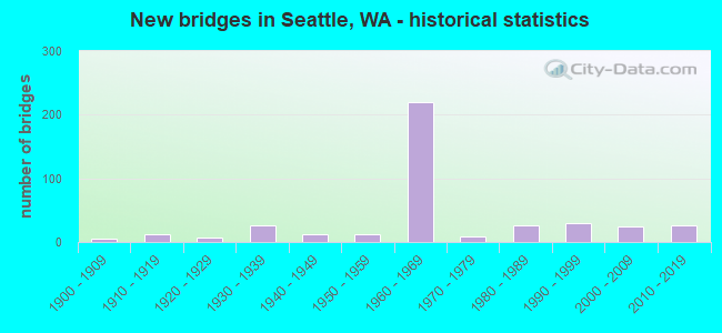
- New bridges - historical statistics
- 61900-1909
- 121910-1919
- 71920-1929
- 261930-1939
- 121940-1949
- 131950-1959
- 2191960-1969
- 91970-1979
- 271980-1989
- 291990-1999
- 252000-2009
- 272010-2019
- 12020-2022
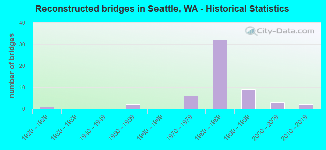
- Reconstructed bridges - Historical Statistics
- 11920-1929
- 01930-1939
- 01940-1949
- 21950-1959
- 01960-1969
- 61970-1979
- 321980-1989
- 91990-1999
- 32000-2009
- 22010-2019
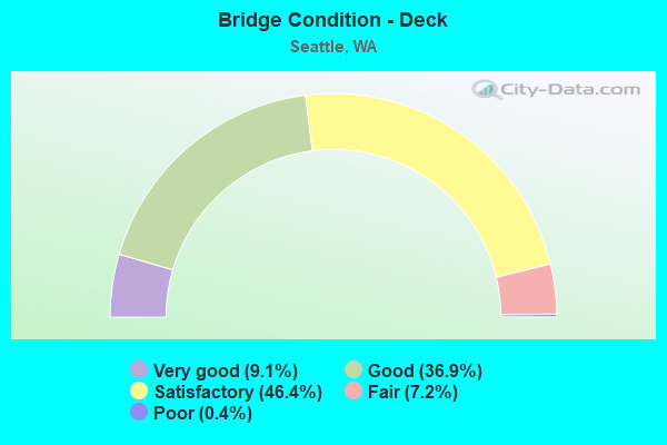
- Bridge Condition - Deck
- 9.1%Very good
- 36.9%Good
- 46.4%Satisfactory
- 7.2%Fair
- 0.4%Poor
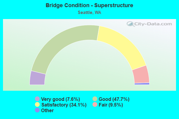
- Bridge Condition - Superstructure
- 7.6%Very good
- 47.7%Good
- 34.1%Satisfactory
- 9.5%Fair
- 1.1%Poor
- 0.4%Critical
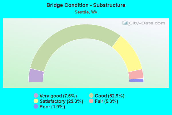
- Bridge Condition - Substructure
- 7.6%Very good
- 62.9%Good
- 22.3%Satisfactory
- 5.3%Fair
- 1.9%Poor
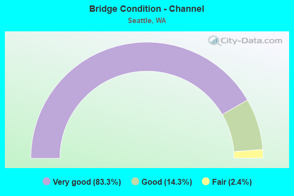
- Bridge Condition - Channel
- 83.3%Very good
- 14.3%Good
- 2.4%Fair
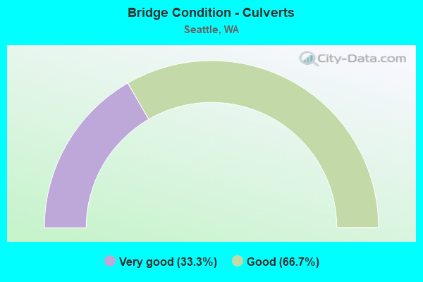
- Bridge Condition - Culverts
- 33.3%Very good
- 66.7%Good
Find on map >> Show street view
Structure Number: 6653A, Location: 2.1 N JCT I-90 (Lat: 47.622917, Lng: -122.328667), Route carried "on" structure: Ramp Interstate 5, Year Built: 1962, Status: Open, Structure Length: 6.49m (21.29ft), Average Daily Traffic: 10,636 (year 2012), Truck Traffic: 5%, Average Future Daily Traffic: 17,783 (year 2036), Design Load: HS 20, Features Intersected: TERRAIN
Minimum Vertical Clearance: 30+ m (98+ ft), Kilometerpoint: 0.001, Lanes on structure: 1, Owner: State Highway Agency, Approaching Roadway Width: 7.0m (23.0ft), Material/Design: Concrete continuous, Design/Construction: Box Beam or Girders - Multiple, Number Of Spans In Main Unit: 3, Length of Maximum Span: 25.3m (83.0ft), Curb or Sidewalk Widths: Left: 0.5m (1.6ft), Right: 0.5m (1.6ft), Curb-To-Curb Width: 6.4m (21.0ft), Out-to-Out Width: 7.8m (25.6ft)
Condition: Deck: Satisfactory, Superstructure: Good, Substructure: Good, Operating Rating: 75.3 metric tons, Method Used To Determine Operating Rating: Load Factor (LF), Inventory Rating: 44.4 metric tons, Method Used To Determine Inventory Rating: Load Factor (LF), Structural Evaluation: Better than present minimum criteria, Deck Geometry: Somewhat better than minimum adequacy, Approach Roadway Alignment: Equal to present desirable criteria, Length Of Structure Improvement: 6.49m (21.29ft), Designated Inspection Frequency: Every 24 months, Inspection Date: April 2021, Bridge Improvement Cost: $1,065,000, Roadway Improvement Cost: $213,000, Total Project Cost: $2,130,000 ( Estimate for 2014), Deck Structure Type: Concrete Cast-file-Place, Wearing Surface/Protective System: Wearing Surface: Latex Concrete
Find on map >> Show street view
Structure Number: 6800A, Location: 2.9 N JCT I-90 (Lat: 47.618556, Lng: -122.328664), Route carried "on" structure: Interstate 5, Year Built: 1962, Status: Open, Structure Length: 215.71m (707.71ft), Average Daily Traffic: 95,249 (year 2019), Truck Traffic: 5%, Average Future Daily Traffic: 134,491 (year 2039), Design Load: HS 20, Features Intersected: DENNY WAY-LAKEVIEW V
Minimum Vertical Clearance: 30+ m (98+ ft), Kilometerpoint: 267.730, Lanes on structure: 5, Lanes under structure: 7, Base Highway Network: Yes, Owner: State Highway Agency, Approaching Roadway Width: 18.3m (60.0ft), Skew: 4 degrees, Material/Design: Concrete continuous, Design/Construction: Box Beam or Girders - Multiple, Number Of Spans In Main Unit: 53, Number Of Approach Spans: 32, Length of Maximum Span: 31.7m (104.0ft), Curb or Sidewalk Widths: Left: 0.5m (1.6ft), Right: 0.5m (1.6ft), Curb-To-Curb Width: 18.3m (60.0ft), Out-to-Out Width: 19.7m (64.6ft)
Condition: Deck: Satisfactory, Superstructure: Satisfactory, Substructure: Satisfactory, Operating Rating: 65.3 metric tons, Method Used To Determine Operating Rating: Load Factor (LF), Inventory Rating: 39.9 metric tons, Method Used To Determine Inventory Rating: Load Factor (LF), Structural Evaluation: Equal to present minimum criteria, Deck Geometry: High priority of replacement, Underclear: High priority of corrective action, Approach Roadway Alignment: Equal to present desirable criteria, Length Of Structure Improvement: 215.71m (707.71ft), Designated Inspection Frequency: Every 24 months, Inspection Date: July 2021, Bridge Improvement Cost: $87,755,000, Roadway Improvement Cost: $17,551,000, Total Project Cost: $175,510,000 ( Estimate for 2014), Deck Structure Type: Concrete Cast-file-Place, Wearing Surface/Protective System: Wearing Surface: Latex Concrete
Find on map >> Show street view
Structure Number: 6800B, Location: 2.4 N JCT I-90 (Lat: 47.626417, Lng: -122.328167), Route carried "on" structure: Interstate 5, Year Built: 1963, Status: Posted for load, Structure Length: 11.61m (38.09ft), Average Daily Traffic: 94,343 (year 2019), Truck Traffic: 5%, Average Future Daily Traffic: 133,212 (year 2039), Design Load: HS 20, Features Intersected: TERRAIN
Minimum Vertical Clearance: 30+ m (98+ ft), Kilometerpoint: 268.616, Lanes on structure: 4, Base Highway Network: Yes, Owner: State Highway Agency, Approaching Roadway Width: 20.1m (65.9ft), Material/Design: Concrete continuous, Design/Construction: Tee Beam, Number Of Spans In Main Unit: 11, Length of Maximum Span: 11.6m (38.1ft), Curb or Sidewalk Widths: Left: 0.5m (1.6ft), Right: 0.0m, Curb-To-Curb Width: 20.1m (65.9ft), Out-to-Out Width: 10.1m (33.1ft)
Condition: Deck: Satisfactory, Superstructure: Good, Substructure: Satisfactory, Operating Rating: 30.5 metric tons, Method Used To Determine Operating Rating: Load and Resistance Factor Rating (LRFR) rating reported by rating factor(RF) method using HL-93 loadings, Inventory Rating: 23.3 metric tons, Method Used To Determine Inventory Rating: Load and Resistance Factor Rating (LRFR) rating reported by rating factor(RF) method using HL-93 loadings, Structural Evaluation: Somewhat better than minimum adequacy, Deck Geometry: Equal to present minimum criteria, Approach Roadway Alignment: Equal to present desirable criteria, Bridge Posting: Required (Relationship of Operating Rating to Maximum Legal Load: 10.0 - 19.9% below), Length Of Structure Improvement: 11.61m (38.09ft), Designated Inspection Frequency: Every 24 months, Inspection Date: July 2021, Bridge Improvement Cost: $5,182,000, Roadway Improvement Cost: $1,036,000, Total Project Cost: $10,363,000 ( Estimate for 2014), Deck Structure Type: Concrete Cast-file-Place, Wearing Surface/Protective System: Wearing Surface: Monolithic Concrete
Find on map >> Show street view
Structure Number: 6800C, Location: 2.5 N JCT I-90 (Lat: 47.625242, Lng: -122.329028), Route carried "on" structure: City street , Year Built: 1963, Status: Open, Structure Length: 37.03m (121.49ft), Average Daily Traffic: 7,000 (year 2002), Truck Traffic: 5%, Average Future Daily Traffic: 12,236 (year 2036), Design Load: HS 20, Features Intersected: I-5, Facility Carried by Structure: LAKEVIEW BLVD
Minimum Vertical Clearance: 30+ m (98+ ft), Kilometerpoint: 1.947, Lanes on structure: 2, Lanes under structure: 16, Owner: State Highway Agency, Approaching Roadway Width: 19.2m (63.0ft), Skew: 9 degrees, Material/Design: Concrete continuous, Design/Construction: Box Beam or Girders - Multiple, Number Of Spans In Main Unit: 15, Length of Maximum Span: 32.6m (107.0ft), Curb or Sidewalk Widths: Left: 1.5m (4.9ft), Right: 1.5m (4.9ft), Curb-To-Curb Width: 8.5m (27.9ft), Out-to-Out Width: 12.1m (39.7ft)
Condition: Deck: Good, Superstructure: Good, Substructure: Good, Operating Rating: 54.4 metric tons, Method Used To Determine Operating Rating: Load Factor (LF), Inventory Rating: 32.7 metric tons, Method Used To Determine Inventory Rating: Load Factor (LF), Structural Evaluation: Better than present minimum criteria, Deck Geometry: Meets minimum limits, Underclear: High priority of corrective action, Approach Roadway Alignment: Equal to present desirable criteria, Length Of Structure Improvement: 37.03m (121.49ft), Designated Inspection Frequency: Every 24 months, Inspection Date: April 2021, Bridge Improvement Cost: $15,795,000, Roadway Improvement Cost: $3,159,000, Total Project Cost: $31,590,000 ( Estimate for 2014), Deck Structure Type: Concrete Cast-file-Place, Wearing Surface/Protective System: Wearing Surface: Monolithic Concrete
Find on map >> Show street view
Structure Number: 6800F, Location: 2.5 N JCT I-90 (Lat: 47.629472, Lng: -122.327778), Route carried "on" structure: Ramp Interstate 5, Year Built: 1962, Status: Open, Structure Length: 22.31m (73.20ft), Average Daily Traffic: 13,125 (year 2012), Truck Traffic: 5%, Average Future Daily Traffic: 21,945 (year 2036), Design Load: HS 20, Features Intersected: TERRAIN
Minimum Vertical Clearance: 30+ m (98+ ft), Kilometerpoint: 0.145, Lanes on structure: 1, Owner: State Highway Agency, Approaching Roadway Width: 6.7m (22.0ft), Material/Design: Concrete continuous, Design/Construction: Box Beam or Girders - Multiple, Number Of Spans In Main Unit: 8, Length of Maximum Span: 31.7m (104.0ft), Curb or Sidewalk Widths: Left: 0.5m (1.6ft), Right: 0.5m (1.6ft), Curb-To-Curb Width: 6.4m (21.0ft), Out-to-Out Width: 7.8m (25.6ft)
Condition: Deck: Satisfactory, Superstructure: Good, Substructure: Good, Operating Rating: 46.0 metric tons, Method Used To Determine Operating Rating: Load and Resistance Factor Rating (LRFR) rating reported by rating factor(RF) method using HL-93 loadings, Inventory Rating: 35.6 metric tons, Method Used To Determine Inventory Rating: Load and Resistance Factor Rating (LRFR) rating reported by rating factor(RF) method using HL-93 loadings, Structural Evaluation: Better than present minimum criteria, Deck Geometry: Somewhat better than minimum adequacy, Approach Roadway Alignment: Equal to present desirable criteria, Length Of Structure Improvement: 22.31m (73.20ft), Designated Inspection Frequency: Every 24 months, Inspection Date: August 2021, Bridge Improvement Cost: $3,514,000, Roadway Improvement Cost: $703,000, Total Project Cost: $7,027,000 ( Estimate for 2014), Deck Structure Type: Concrete Cast-file-Place, Wearing Surface/Protective System: Wearing Surface: Latex Concrete
Find on map >> Show street view
Structure Number: 6800G, Location: 2.4 N JCT I-90 (Lat: 47.625856, Lng: -122.329244), Route carried "on" structure: City street , Year Built: 1963, Status: Open, Structure Length: 3.81m (12.50ft), Average Daily Traffic: 14,621 (year 2002), Truck Traffic: 5%, Average Future Daily Traffic: 27,049 (year 2036), Design Load: HS 20, Features Intersected: I-5 RAMPS, Facility Carried by Structure: EASTLAKE AVE
Minimum Vertical Clearance: 30+ m (98+ ft), Kilometerpoint: 0.740, Lanes on structure: 2, Lanes under structure: 4, Base Highway Network: Yes, Owner: State Highway Agency, Approaching Roadway Width: 18.3m (60.0ft), Skew: 4 degrees, Material/Design: Concrete continuous, Design/Construction: Box Beam or Girders - Multiple, Number Of Spans In Main Unit: 2, Length of Maximum Span: 22.6m (74.1ft), Curb or Sidewalk Widths: Left: 2.4m (7.9ft), Right: 1.8m (5.9ft), Curb-To-Curb Width: 14.0m (45.9ft), Out-to-Out Width: 18.8m (61.7ft)
Condition: Deck: Good, Superstructure: Good, Substructure: Good, Operating Rating: 96.9 metric tons, Method Used To Determine Operating Rating: Load and Resistance Factor Rating (LRFR) rating reported by rating factor(RF) method using HL-93 loadings, Inventory Rating: 79.7 metric tons, Method Used To Determine Inventory Rating: Load and Resistance Factor Rating (LRFR) rating reported by rating factor(RF) method using HL-93 loadings, Structural Evaluation: Better than present minimum criteria, Deck Geometry: Superior to present desirable criteria, Underclear: High priority of corrective action, Approach Roadway Alignment: Equal to present desirable criteria, Length Of Structure Improvement: 3.81m (12.50ft), Designated Inspection Frequency: Every 48 months, Inspection Date: April 2019, Bridge Improvement Cost: $1,550,000, Roadway Improvement Cost: $310,000, Total Project Cost: $3,100,000 ( Estimate for 2014), Deck Structure Type: Concrete Cast-file-Place, Wearing Surface/Protective System: Wearing Surface: Monolithic Concrete
Find on map >> Show street view
Structure Number: 6800H, Location: 2.1 N JCT I-90 (Lat: 47.629525, Lng: -122.327503), Route carried "on" structure: Ramp Interstate 5, Year Built: 1964, Status: Open, Structure Length: 22.65m (74.31ft), Average Daily Traffic: 3,999 (year 2012), Truck Traffic: 1%, Average Future Daily Traffic: 6,686 (year 2036), Design Load: HS 20, Features Intersected: TERRAIN
Minimum Vertical Clearance: 30+ m (98+ ft), Kilometerpoint: 0.113, Lanes on structure: 1, Owner: State Highway Agency, Approaching Roadway Width: 7.6m (24.9ft), Material/Design: Concrete continuous, Design/Construction: Slab, Number Of Spans In Main Unit: 21, Length of Maximum Span: 11.6m (38.1ft), Curb or Sidewalk Widths: Left: 0.5m (1.6ft), Right: 0.5m (1.6ft), Curb-To-Curb Width: 6.4m (21.0ft), Out-to-Out Width: 7.8m (25.6ft)
Condition: Deck: Satisfactory, Superstructure: Good, Substructure: Good, Operating Rating: 75.3 metric tons, Method Used To Determine Operating Rating: Load Factor (LF), Inventory Rating: 44.4 metric tons, Method Used To Determine Inventory Rating: Load Factor (LF), Structural Evaluation: Better than present minimum criteria, Deck Geometry: Somewhat better than minimum adequacy, Approach Roadway Alignment: Equal to present desirable criteria, Length Of Structure Improvement: 22.65m (74.31ft), Designated Inspection Frequency: Every 24 months, Inspection Date: April 2021, Bridge Improvement Cost: $4,012,000, Roadway Improvement Cost: $802,000, Total Project Cost: $8,024,000 ( Estimate for 2014), Deck Structure Type: Concrete Cast-file-Place, Wearing Surface/Protective System: Wearing Surface: Monolithic Concrete
Find on map >> Show street view
Structure Number: 6819A, Location: 0.3 E JCT I-5 (Lat: 47.642750, Lng: -122.317667), Route carried "on" structure: State highway 520, Year Built: 1963, Status: Open, Structure Length: 86.56m (283.99ft), Average Daily Traffic: 51,673 (year 2019), Truck Traffic: 3%, Average Future Daily Traffic: 72,962 (year 2039), Design Load: HS 20, Features Intersected: PORTAGE BAY
Minimum Vertical Clearance: 30+ m (98+ ft), Kilometerpoint: 0.467, Lanes on structure: 4, Lanes under structure: 2, Base Highway Network: Yes, Owner: State Highway Agency, Approaching Roadway Width: 18.3m (60.0ft), Skew: 30 degrees, Material/Design: Prestressed concrete, Design/Construction: Stringer/Multi-beam, Number Of Spans In Main Unit: 29, Length of Maximum Span: 30.5m (100.1ft), Curb or Sidewalk Widths: Left: 0.5m (1.6ft), Right: 0.5m (1.6ft), Curb-To-Curb Width: 17.1m (56.1ft), Out-to-Out Width: 19.9m (65.3ft)
Condition: Deck: Satisfactory, Superstructure: Good, Substructure: Fair, Channel: Very good, Operating Rating: 16.5 metric tons, Method Used To Determine Operating Rating: Load and Resistance Factor Rating (LRFR) rating reported by rating factor(RF) method using HL-93 loadings, Inventory Rating: 12.6 metric tons, Method Used To Determine Inventory Rating: Load and Resistance Factor Rating (LRFR) rating reported by rating factor(RF) method using HL-93 loadings, Structural Evaluation: High priority of corrective action, Deck Geometry: Meets minimum limits, Underclear: Meets minimum limits, Waterway Adequacy: Equal to present desirable criteria, Approach Roadway Alignment: Equal to present desirable criteria, Length Of Structure Improvement: 86.56m (283.99ft), Designated Inspection Frequency: Every 24 months, Underwater Inspection Frequency: Every 60 months, Inspection Date: March 2018, Underwater Inspection Date: May 2018, Bridge Improvement Cost: $35,216,000, Roadway Improvement Cost: $7,043,000, Total Project Cost: $70,432,000 ( Estimate for 2014), Deck Structure Type: Concrete Cast-file-Place, Wearing Surface/Protective System: Wearing Surface: Monolithic Concrete
Find on map >> Show street view
Structure Number: 6819B, Location: 0.8 E JCT I-5 (Lat: 47.643558, Lng: -122.304664), Route carried "on" structure: Ramp State highway 520, Year Built: 1963, Status: Open, Structure Length: 11.43m (37.50ft), Average Daily Traffic: 16,652 (year 2019), Truck Traffic: 5%, Average Future Daily Traffic: 23,512 (year 2039), Design Load: HS 20, Features Intersected: PORTAGE BAY
Minimum Vertical Clearance: 30+ m (98+ ft), Kilometerpoint: 0.097, Lanes on structure: 1, Owner: State Highway Agency, Approaching Roadway Width: 5.5m (18.0ft), Material/Design: Prestressed concrete, Design/Construction: Stringer/Multi-beam, Number Of Spans In Main Unit: 5, Length of Maximum Span: 22.9m (75.1ft), Curb or Sidewalk Widths: Left: 0.5m (1.6ft), Right: 0.5m (1.6ft), Curb-To-Curb Width: 5.5m (18.0ft), Out-to-Out Width: 6.9m (22.6ft)
Condition: Deck: Satisfactory, Superstructure: Good, Substructure: Good, Channel: Very good, Operating Rating: 43.4 metric tons, Method Used To Determine Operating Rating: Load and Resistance Factor Rating (LRFR) rating reported by rating factor(RF) method using HL-93 loadings, Inventory Rating: 33.4 metric tons, Method Used To Determine Inventory Rating: Load and Resistance Factor Rating (LRFR) rating reported by rating factor(RF) method using HL-93 loadings, Structural Evaluation: Better than present minimum criteria, Deck Geometry: Meets minimum limits, Waterway Adequacy: Equal to present desirable criteria, Approach Roadway Alignment: Equal to present desirable criteria, Length Of Structure Improvement: 11.43m (37.50ft), Designated Inspection Frequency: Every 48 months, Underwater Inspection Frequency: Every 60 months, Inspection Date: April 2018, Underwater Inspection Date: May 2018, Bridge Improvement Cost: $1,500,000, Roadway Improvement Cost: $300,000, Total Project Cost: $3,000,000 ( Estimate for 2014), Deck Structure Type: Concrete Cast-file-Place, Wearing Surface/Protective System: Wearing Surface: Monolithic Concrete
Find on map >> Show street view
Structure Number: 6861A, Location: 0.1 E JCT I-5 (Lat: 47.642583, Lng: -122.317972), Route carried "on" structure: City street , Year Built: 1963, Status: Open, Structure Length: 4.69m (15.39ft), Average Daily Traffic: 5,000 (year 2012), Truck Traffic: 3%, Average Future Daily Traffic: 7,640 (year 2036), Design Load: HS 20, Features Intersected: SR 520, Facility Carried by Structure: DELMAR DRIVE
Minimum Vertical Clearance: 30+ m (98+ ft), Kilometerpoint: 0.370, Lanes on structure: 2, Lanes under structure: 5, Owner: State Highway Agency, Approaching Roadway Width: 14.6m (47.9ft), Skew: 3 degrees, Material/Design: Concrete continuous, Design/Construction: Box Beam or Girders - Multiple, Number Of Spans In Main Unit: 2, Length of Maximum Span: 33.2m (108.9ft), Curb or Sidewalk Widths: Left: 1.8m (5.9ft), Right: 1.8m (5.9ft), Curb-To-Curb Width: 11.0m (36.1ft), Out-to-Out Width: 15.1m (49.5ft)
Condition: Deck: Good, Superstructure: Good, Substructure: Good, Operating Rating: 55.3 metric tons, Method Used To Determine Operating Rating: Load Factor (LF), Inventory Rating: 32.7 metric tons, Method Used To Determine Inventory Rating: Load Factor (LF), Structural Evaluation: Better than present minimum criteria, Deck Geometry: Somewhat better than minimum adequacy, Underclear: High priority of corrective action, Approach Roadway Alignment: Equal to present desirable criteria, Length Of Structure Improvement: 4.69m (15.39ft), Designated Inspection Frequency: Every 48 months, Inspection Date: June 2018, Bridge Improvement Cost: $1,540,000, Roadway Improvement Cost: $308,000, Total Project Cost: $3,080,000 ( Estimate for 2014), Deck Structure Type: Concrete Cast-file-Place, Wearing Surface/Protective System: Wearing Surface: Monolithic Concrete
Find on map >> Show street view
Structure Number: 6861B, Location: 0.1 E JCT I-5 (Lat: 47.642086, Lng: -122.320053), Route carried "on" structure: City street , Year Built: 1962, Status: Open, Structure Length: 8.69m (28.51ft), Average Daily Traffic: 13,800 (year 2012), Truck Traffic: 3%, Average Future Daily Traffic: 21,086 (year 2036), Design Load: HS 20, Features Intersected: SR 520, Facility Carried by Structure: 10TH AVE
Minimum Vertical Clearance: 30+ m (98+ ft), Kilometerpoint: 0.032, Lanes on structure: 3, Lanes under structure: 7, Owner: State Highway Agency, Approaching Roadway Width: 13.4m (44.0ft), Material/Design: Concrete continuous, Design/Construction: Box Beam or Girders - Multiple, Number Of Spans In Main Unit: 3, Length of Maximum Span: 35.7m (117.1ft), Curb or Sidewalk Widths: Left: 2.4m (7.9ft), Right: 2.4m (7.9ft), Curb-To-Curb Width: 13.4m (44.0ft), Out-to-Out Width: 18.8m (61.7ft)
Condition: Deck: Good, Superstructure: Good, Substructure: Good, Operating Rating: 32.7 metric tons, Method Used To Determine Operating Rating: Load and Resistance Factor Rating (LRFR) rating reported by rating factor(RF) method using HL-93 loadings, Inventory Rating: 25.3 metric tons, Method Used To Determine Inventory Rating: Load and Resistance Factor Rating (LRFR) rating reported by rating factor(RF) method using HL-93 loadings, Structural Evaluation: Equal to present minimum criteria, Deck Geometry: Somewhat better than minimum adequacy, Underclear: High priority of corrective action, Approach Roadway Alignment: Equal to present desirable criteria, Length Of Structure Improvement: 8.69m (28.51ft), Designated Inspection Frequency: Every 24 months, Inspection Date: August 2021, Bridge Improvement Cost: $2,622,000, Roadway Improvement Cost: $524,000, Total Project Cost: $5,244,000 ( Estimate for 2014), Deck Structure Type: Concrete Cast-file-Place, Wearing Surface/Protective System: Wearing Surface: Epoxy Overlay
Find on map >> Show street view
Structure Number: 6872B, Location: 0.4 E JCT SR 513 (Lat: 47.641897, Lng: -122.297186), Route carried "on" structure: Ramp State highway 520, Year Built: 1963, Status: Open, Structure Length: 11.73m (38.48ft), Average Daily Traffic: 3,985 (year 2019), Truck Traffic: 5%, Average Future Daily Traffic: 5,626 (year 2039), Design Load: HS 20+Mod, Features Intersected: ARBORETUM
Minimum Vertical Clearance: 30+ m (98+ ft), Kilometerpoint: 0.048, Lanes on structure: 1, Owner: State Highway Agency, Approaching Roadway Width: 14.3m (46.9ft), Skew: 4 degrees, Material/Design: Prestressed concrete, Design/Construction: Stringer/Multi-beam, Number Of Spans In Main Unit: 5, Length of Maximum Span: 30.5m (100.1ft), Curb or Sidewalk Widths: Left: 0.5m (1.6ft), Right: 0.5m (1.6ft), Curb-To-Curb Width: 18.0m (59.1ft), Out-to-Out Width: 19.5m (64.0ft)
Condition: Deck: Good, Superstructure: Good, Substructure: Good, Operating Rating: 20.4 metric tons, Method Used To Determine Operating Rating: Load and Resistance Factor Rating (LRFR) rating reported by rating factor(RF) method using HL-93 loadings, Inventory Rating: 15.9 metric tons, Method Used To Determine Inventory Rating: Load and Resistance Factor Rating (LRFR) rating reported by rating factor(RF) method using HL-93 loadings, Structural Evaluation: High priority of corrective action, Deck Geometry: Superior to present desirable criteria, Approach Roadway Alignment: Equal to present desirable criteria, Length Of Structure Improvement: 11.73m (38.48ft), Designated Inspection Frequency: Every 48 months, Inspection Date: April 2018, Bridge Improvement Cost: $3,773,000, Roadway Improvement Cost: $755,000, Total Project Cost: $7,546,000 ( Estimate for 2014), Deck Structure Type: Concrete Cast-file-Place, Wearing Surface/Protective System: Wearing Surface: Monolithic Concrete
Find on map >> Show street view
Structure Number: 6911A, Location: 2.6 N JCT SR 520 (Lat: 47.679806, Lng: -122.321333), Route carried "on" structure: City street , Year Built: 1962, Status: Open, Structure Length: 10.06m (33.01ft), Average Daily Traffic: 8,682 (year 2021), Truck Traffic: 5%, Average Future Daily Traffic: 12,404 (year 2041), Design Load: HS 20, Features Intersected: I-5, Facility Carried by Structure: NE 70TH-NE 71ST ST
Minimum Vertical Clearance: 30+ m (98+ ft), Kilometerpoint: 0.048, Lanes on structure: 2, Lanes under structure: 12, Owner: State Highway Agency, Approaching Roadway Width: 16.5m (54.1ft), Skew: 4 degrees, Material/Design: Concrete continuous, Design/Construction: Box Beam or Girders - Multiple, Number Of Spans In Main Unit: 5, Length of Maximum Span: 24.1m (79.1ft), Curb or Sidewalk Widths: Left: 0.6m (2.0ft), Right: 2.4m (7.9ft), Curb-To-Curb Width: 13.4m (44.0ft), Out-to-Out Width: 17.1m (56.1ft)
Condition: Deck: Satisfactory, Superstructure: Good, Substructure: Good, Operating Rating: 78.0 metric tons, Method Used To Determine Operating Rating: Load Factor (LF), Inventory Rating: 46.3 metric tons, Method Used To Determine Inventory Rating: Load Factor (LF), Structural Evaluation: Better than present minimum criteria, Deck Geometry: Equal to present minimum criteria, Underclear: High priority of corrective action, Approach Roadway Alignment: Equal to present desirable criteria, Length Of Structure Improvement: 10.06m (33.01ft), Designated Inspection Frequency: Every 24 months, Inspection Date: May 2021, Bridge Improvement Cost: $3,696,000, Roadway Improvement Cost: $739,000, Total Project Cost: $7,392,000 ( Estimate for 2014), Deck Structure Type: Concrete Cast-file-Place, Wearing Surface/Protective System: Wearing Surface: Monolithic Concrete
Find on map >> Show street view
Structure Number: 6911B, Location: 2.2 N JCT SR 520 (Lat: 47.679611, Lng: -122.320083), Route carried "on" structure: Ramp Interstate 5, Year Built: 1963, Status: Open, Structure Length: 5.55m (18.21ft), Average Daily Traffic: 5,454 (year 2019), Truck Traffic: 5%, Average Future Daily Traffic: 7,701 (year 2039), Design Load: HS 20, Features Intersected: I-5 N RAMP TO SR 522 E
Minimum Vertical Clearance: 30+ m (98+ ft), Kilometerpoint: 0.001, Lanes on structure: 1, Lanes under structure: 1, Owner: State Highway Agency, Approaching Roadway Width: 7.0m (23.0ft), Material/Design: Concrete continuous, Design/Construction: Box Beam or Girders - Multiple, Number Of Spans In Main Unit: 3, Length of Maximum Span: 25.6m (84.0ft), Curb or Sidewalk Widths: Left: 0.5m (1.6ft), Right: 0.5m (1.6ft), Curb-To-Curb Width: 6.4m (21.0ft), Out-to-Out Width: 8.0m (26.2ft)
Condition: Deck: Satisfactory, Superstructure: Good, Substructure: Good, Operating Rating: 59.0 metric tons, Method Used To Determine Operating Rating: Load Factor (LF), Inventory Rating: 34.5 metric tons, Method Used To Determine Inventory Rating: Load Factor (LF), Structural Evaluation: Better than present minimum criteria, Deck Geometry: Somewhat better than minimum adequacy, Underclear: Meets minimum limits, Approach Roadway Alignment: Equal to present desirable criteria, Length Of Structure Improvement: 5.55m (18.21ft), Designated Inspection Frequency: Every 24 months, Inspection Date: May 2021, Bridge Improvement Cost: $910,000, Roadway Improvement Cost: $182,000, Total Project Cost: $1,820,000 ( Estimate for 2014), Deck Structure Type: Concrete Cast-file-Place, Wearing Surface/Protective System: Wearing Surface: Monolithic Concrete
Find on map >> Show street view
Structure Number: 6911C, Location: 6.2 N JCT I-90 (Lat: 47.680528, Lng: -122.320944), Route carried "on" structure: Ramp Interstate 5, Year Built: 1962, Status: Open, Structure Length: 12.92m (42.39ft), Average Daily Traffic: 6,878 (year 2019), Truck Traffic: 4%, Average Future Daily Traffic: 9,711 (year 2039), Design Load: HS 20, Features Intersected: I-5 NB,I-5 EXPRESS,RAMP
Minimum Vertical Clearance: 30+ m (98+ ft), Kilometerpoint: 0.418, Lanes on structure: 1, Lanes under structure: 7, Owner: State Highway Agency, Approaching Roadway Width: 7.6m (24.9ft), Material/Design: Concrete continuous, Design/Construction: Box Beam or Girders - Multiple, Number Of Spans In Main Unit: 4, Length of Maximum Span: 36.6m (120.1ft), Curb or Sidewalk Widths: Left: 0.5m (1.6ft), Right: 0.5m (1.6ft), Curb-To-Curb Width: 6.7m (22.0ft), Out-to-Out Width: 8.1m (26.6ft)
Condition: Deck: Good, Superstructure: Good, Substructure: Good, Operating Rating: 59.0 metric tons, Method Used To Determine Operating Rating: Load Factor (LF), Inventory Rating: 34.5 metric tons, Method Used To Determine Inventory Rating: Load Factor (LF), Structural Evaluation: Better than present minimum criteria, Deck Geometry: Equal to present minimum criteria, Underclear: High priority of corrective action, Approach Roadway Alignment: Equal to present desirable criteria, Length Of Structure Improvement: 12.92m (42.39ft), Designated Inspection Frequency: Every 24 months, Inspection Date: May 2021, Bridge Improvement Cost: $2,290,000, Roadway Improvement Cost: $458,000, Total Project Cost: $4,579,000 ( Estimate for 2014), Deck Structure Type: Concrete Cast-file-Place, Wearing Surface/Protective System: Wearing Surface: Monolithic Concrete
Find on map >> Show street view
Structure Number: 6911D, Location: 0.1 E JCT I-5 (Lat: 47.682056, Lng: -122.320417), Route carried "on" structure: Ramp State highway 522, Year Built: 1962, Status: Open, Structure Length: 10.91m (35.79ft), Average Daily Traffic: 15,936 (year 2019), Truck Traffic: 6%, Average Future Daily Traffic: 22,501 (year 2039), Design Load: HS 20, Features Intersected: W-S RAMP I-5
Minimum Vertical Clearance: 30+ m (98+ ft), Kilometerpoint: 0.193, Lanes on structure: 1, Lanes under structure: 10, Owner: State Highway Agency, Approaching Roadway Width: 7.3m (24.0ft), Skew: 9 degrees, Material/Design: Concrete continuous, Design/Construction: Box Beam or Girders - Multiple, Number Of Spans In Main Unit: 5, Length of Maximum Span: 28.3m (92.8ft), Curb-To-Curb Width: 7.3m (24.0ft), Out-to-Out Width: 8.1m (26.6ft)
Condition: Deck: Satisfactory, Superstructure: Satisfactory, Substructure: Good, Operating Rating: 76.2 metric tons, Method Used To Determine Operating Rating: Load Factor (LF), Inventory Rating: 44.4 metric tons, Method Used To Determine Inventory Rating: Load Factor (LF), Structural Evaluation: Equal to present minimum criteria, Deck Geometry: Better than present minimum criteria, Underclear: High priority of corrective action, Approach Roadway Alignment: Equal to present minimum criteria, Length Of Structure Improvement: 10.91m (35.79ft), Designated Inspection Frequency: Every 24 months, Inspection Date: April 2021, Bridge Improvement Cost: $1,862,000, Roadway Improvement Cost: $372,000, Total Project Cost: $3,723,000 ( Estimate for 2014), Deck Structure Type: Concrete Cast-file-Place, Wearing Surface/Protective System: Wearing Surface: Monolithic Concrete
Find on map >> Show street view
Structure Number: 7110A, Location: 1.2 N JCT I-90 (Lat: 47.604194, Lng: -122.327250), Route carried "on" structure: Interstate 5, Year Built: 1964, Status: Open, Structure Length: 143.68m (471.39ft), Average Daily Traffic: 61,394 (year 2019), Truck Traffic: 5%, Average Future Daily Traffic: 86,688 (year 2039), Design Load: HS 20, Features Intersected: JAMES, CHERRY, REVERS
Minimum Vertical Clearance: 30+ m (98+ ft), Kilometerpoint: 266.057, Lanes on structure: 4, Lanes under structure: 4, Base Highway Network: Yes, Owner: State Highway Agency, Approaching Roadway Width: 15.8m (51.8ft), Material/Design: Concrete continuous, Design/Construction: Box Beam or Girders - Multiple, Number Of Spans In Main Unit: 26, Number Of Approach Spans: 34, Length of Maximum Span: 25.9m (85.0ft), Curb-To-Curb Width: 13.4m (44.0ft), Out-to-Out Width: 15.8m (51.8ft)
Condition: Deck: Satisfactory, Superstructure: Satisfactory, Substructure: Good, Operating Rating: 29.8 metric tons, Method Used To Determine Operating Rating: Load and Resistance Factor Rating (LRFR) rating reported by rating factor(RF) method using HL-93 loadings, Inventory Rating: 23.0 metric tons, Method Used To Determine Inventory Rating: Load and Resistance Factor Rating (LRFR) rating reported by rating factor(RF) method using HL-93 loadings, Structural Evaluation: Somewhat better than minimum adequacy, Deck Geometry: High priority of replacement, Underclear: High priority of corrective action, Approach Roadway Alignment: Equal to present desirable criteria, Length Of Structure Improvement: 143.68m (471.39ft), Designated Inspection Frequency: Every 24 months, Inspection Date: July 2021, Bridge Improvement Cost: $50,911,000, Roadway Improvement Cost: $10,182,000, Total Project Cost: $101,822,000 ( Estimate for 2014), Deck Structure Type: Concrete Cast-file-Place, Wearing Surface/Protective System: Wearing Surface: Monolithic Concrete
Find on map >> Show street view
Structure Number: 7110B, Location: 1.2 N JCT I-90 (Lat: 47.603778, Lng: -122.327250), Route carried "on" structure: Interstate 5, Year Built: 1964, Year Reconstructed: 1991, Status: Open, Structure Length: 24.60m (80.71ft), Average Daily Traffic: 73,276 (year 2019), Truck Traffic: 8%, Average Future Daily Traffic: 103,465 (year 2039), Design Load: HS 20, Features Intersected: SB VIADUCT STA 2195
Minimum Vertical Clearance: 30+ m (98+ ft), Kilometerpoint: 265.992, Lanes on structure: 3, Lanes under structure: 7, Base Highway Network: Yes, Owner: State Highway Agency, Approaching Roadway Width: 14.6m (47.9ft), Material/Design: Concrete continuous, Design/Construction: Box Beam or Girders - Multiple, Number Of Spans In Main Unit: 11, Length of Maximum Span: 24.4m (80.1ft), Curb-To-Curb Width: 11.9m (39.0ft), Out-to-Out Width: 12.8m (42.0ft)
Condition: Deck: Satisfactory, Superstructure: Satisfactory, Substructure: Satisfactory, Operating Rating: 58.0 metric tons, Method Used To Determine Operating Rating: Load Factor (LF), Inventory Rating: 34.5 metric tons, Method Used To Determine Inventory Rating: Load Factor (LF), Structural Evaluation: Equal to present minimum criteria, Deck Geometry: High priority of replacement, Underclear: Meets minimum limits, Approach Roadway Alignment: Equal to present desirable criteria, Length Of Structure Improvement: 24.60m (80.71ft), Designated Inspection Frequency: Every 24 months, Inspection Date: August 2021, Bridge Improvement Cost: $8,070,000, Roadway Improvement Cost: $1,614,000, Total Project Cost: $16,140,000 ( Estimate for 2014), Deck Structure Type: Concrete Cast-file-Place, Wearing Surface/Protective System: Wearing Surface: Latex Concrete
Find on map >> Show street view
Structure Number: 7110C, Location: 1.1 N JCT I-90 (Lat: 47.607056, Lng: -122.330639), Route carried "on" structure: City street , Year Built: 1964, Status: Open, Structure Length: 8.53m (27.99ft), Average Daily Traffic: 30,000 (year 2018), Truck Traffic: 5%, Average Future Daily Traffic: 40,000 (year 2039), Design Load: HS 20, Features Intersected: I-5, Facility Carried by Structure: MADISON ST
Minimum Vertical Clearance: 30+ m (98+ ft), Kilometerpoint: 0.692, Lanes on structure: 5, Lanes under structure: 14, Base Highway Network: Yes, Owner: State Highway Agency, Approaching Roadway Width: 14.6m (47.9ft), Skew: 9 degrees, Material/Design: Concrete continuous, Design/Construction: Box Beam or Girders - Multiple, Number Of Spans In Main Unit: 3, Length of Maximum Span: 31.7m (104.0ft), Curb or Sidewalk Widths: Left: 3.7m (12.1ft), Right: 3.7m (12.1ft), Curb-To-Curb Width: 15.2m (49.9ft), Out-to-Out Width: 23.1m (75.8ft)
Condition: Deck: Satisfactory, Superstructure: Good, Substructure: Good, Operating Rating: 17.8 metric tons, Method Used To Determine Operating Rating: Load and Resistance Factor Rating (LRFR) rating reported by rating factor(RF) method using HL-93 loadings, Inventory Rating: 13.9 metric tons, Method Used To Determine Inventory Rating: Load and Resistance Factor Rating (LRFR) rating reported by rating factor(RF) method using HL-93 loadings, Structural Evaluation: High priority of corrective action, Deck Geometry: High priority of replacement, Underclear: Meets minimum limits, Approach Roadway Alignment: Equal to present desirable criteria, Length Of Structure Improvement: 8.53m (27.99ft), Designated Inspection Frequency: Every 24 months, Inspection Date: August 2021, Bridge Improvement Cost: $2,800,000, Roadway Improvement Cost: $560,000, Total Project Cost: $5,600,000 ( Estimate for 2014), Deck Structure Type: Concrete Cast-file-Place, Wearing Surface/Protective System: Wearing Surface: Monolithic Concrete
Find on map >> Show street view
Structure Number: 7110D, Location: 1.1 N JCT I-90 (Lat: 47.607806, Lng: -122.331250), Route carried "on" structure: City street , Year Built: 1964, Status: Open, Structure Length: 8.50m (27.89ft), Average Daily Traffic: 10,000 (year 2018), Truck Traffic: 5%, Average Future Daily Traffic: 15,000 (year 2039), Design Load: HS 20, Features Intersected: I-5, Facility Carried by Structure: SPRING ST
Minimum Vertical Clearance: 30+ m (98+ ft), Kilometerpoint: 0.708, Lanes on structure: 2, Lanes under structure: 12, Owner: State Highway Agency, Approaching Roadway Width: 17.1m (56.1ft), Skew: 9 degrees, Material/Design: Concrete continuous, Design/Construction: Box Beam or Girders - Multiple, Number Of Spans In Main Unit: 3, Length of Maximum Span: 35.4m (116.1ft), Curb or Sidewalk Widths: Left: 3.0m (9.8ft), Right: 3.0m (9.8ft), Curb-To-Curb Width: 11.0m (36.1ft), Out-to-Out Width: 17.6m (57.7ft)
Condition: Deck: Satisfactory, Superstructure: Good, Substructure: Good, Operating Rating: 38.1 metric tons, Method Used To Determine Operating Rating: Load Factor (LF), Inventory Rating: 22.7 metric tons, Method Used To Determine Inventory Rating: Load Factor (LF), Structural Evaluation: Somewhat better than minimum adequacy, Deck Geometry: Meets minimum limits, Underclear: High priority of corrective action, Approach Roadway Alignment: Equal to present desirable criteria, Length Of Structure Improvement: 8.50m (27.89ft), Designated Inspection Frequency: Every 24 months, Inspection Date: April 2021, Bridge Improvement Cost: $3,236,000, Roadway Improvement Cost: $647,000, Total Project Cost: $6,473,000 ( Estimate for 2014), Deck Structure Type: Concrete Cast-file-Place, Wearing Surface/Protective System: Wearing Surface: Monolithic Concrete
Find on map >> Show street view
Structure Number: 7110E, Location: 1.2 N JCT I-90 (Lat: 47.608722, Lng: -122.331361), Route carried "on" structure: City street , Year Built: 1964, Status: Open, Structure Length: 7.62m (25.00ft), Average Daily Traffic: 10,000 (year 2017), Truck Traffic: 5%, Average Future Daily Traffic: 15,000 (year 2038), Design Load: HS 20, Features Intersected: I-5, Facility Carried by Structure: SENECA ST
Minimum Vertical Clearance: 30+ m (98+ ft), Kilometerpoint: 0.547, Lanes on structure: 3, Lanes under structure: 12, Owner: State Highway Agency, Approaching Roadway Width: 14.6m (47.9ft), Skew: 9 degrees, Material/Design: Concrete continuous, Design/Construction: Box Beam or Girders - Multiple, Number Of Spans In Main Unit: 3, Length of Maximum Span: 29.3m (96.1ft), Curb or Sidewalk Widths: Left: 3.0m (9.8ft), Right: 3.0m (9.8ft), Curb-To-Curb Width: 11.0m (36.1ft), Out-to-Out Width: 18.8m (61.7ft)
Condition: Deck: Satisfactory, Superstructure: Good, Substructure: Good, Operating Rating: 82.5 metric tons, Method Used To Determine Operating Rating: Load Factor (LF), Inventory Rating: 49.0 metric tons, Method Used To Determine Inventory Rating: Load Factor (LF), Structural Evaluation: Better than present minimum criteria, Deck Geometry: High priority of replacement, Underclear: High priority of corrective action, Approach Roadway Alignment: Equal to present desirable criteria, Length Of Structure Improvement: 7.62m (25.00ft), Designated Inspection Frequency: Every 24 months, Inspection Date: August 2021, Bridge Improvement Cost: $2,500,000, Roadway Improvement Cost: $500,000, Total Project Cost: $5,000,000 ( Estimate for 2014), Deck Structure Type: Concrete Cast-file-Place, Wearing Surface/Protective System: Wearing Surface: Monolithic Concrete
Find on map >> Show street view
Structure Number: 7110F, Location: 0.8 N JCT I-90 (Lat: 47.604264, Lng: -122.327078), Route carried "on" structure: Ramp Interstate 5, Year Built: 1964, Status: Open, Structure Length: 21.40m (70.21ft), Average Daily Traffic: 30,675 (year 2012), Truck Traffic: 5%, Average Future Daily Traffic: 51,289 (year 2036), Design Load: HS 20, Features Intersected: NBCD VIADUCT STA 2195
Minimum Vertical Clearance: 30+ m (98+ ft), Kilometerpoint: 2.334, Lanes on structure: 2, Lanes under structure: 7, Owner: State Highway Agency, Approaching Roadway Width: 10.4m (34.1ft), Material/Design: Concrete continuous, Design/Construction: Box Beam or Girders - Multiple, Number Of Spans In Main Unit: 10, Length of Maximum Span: 24.4m (80.1ft), Curb or Sidewalk Widths: Left: 0.5m (1.6ft), Right: 0.5m (1.6ft), Curb-To-Curb Width: 9.8m (32.2ft), Out-to-Out Width: 11.2m (36.7ft)
Condition: Deck: Satisfactory, Superstructure: Good, Substructure: Good, Operating Rating: 17.8 metric tons, Method Used To Determine Operating Rating: Load and Resistance Factor Rating (LRFR) rating reported by rating factor(RF) method using HL-93 loadings, Inventory Rating: 13.9 metric tons, Method Used To Determine Inventory Rating: Load and Resistance Factor Rating (LRFR) rating reported by rating factor(RF) method using HL-93 loadings, Structural Evaluation: High priority of corrective action, Deck Geometry: Equal to present minimum criteria, Underclear: Somewhat better than minimum adequacy, Approach Roadway Alignment: Equal to present desirable criteria, Length Of Structure Improvement: 21.40m (70.21ft), Designated Inspection Frequency: Every 24 months, Inspection Date: August 2021, Bridge Improvement Cost: $5,054,000, Roadway Improvement Cost: $1,011,000, Total Project Cost: $10,109,000 ( Estimate for 2014), Deck Structure Type: Concrete Cast-file-Place, Wearing Surface/Protective System: Wearing Surface: Monolithic Concrete
Find on map >> Show street view
Structure Number: 7110G, Location: 0.8 N JCT I-90 (Lat: 47.603708, Lng: -122.327408), Route carried "on" structure: Ramp Interstate 5, Year Built: 1964, Year Reconstructed: 1991, Status: Open, Structure Length: 24.57m (80.61ft), Average Daily Traffic: 49,417 (year 2012), Truck Traffic: 10%, Average Future Daily Traffic: 82,625 (year 2036), Design Load: HS 20, Features Intersected: SBCD VIADUCT STA 2195
Minimum Vertical Clearance: 30+ m (98+ ft), Kilometerpoint: 0.290, Lanes on structure: 3, Lanes under structure: 7, Owner: State Highway Agency, Approaching Roadway Width: 15.2m (49.9ft), Material/Design: Concrete continuous, Design/Construction: Box Beam or Girders - Multiple, Number Of Spans In Main Unit: 11, Length of Maximum Span: 24.4m (80.1ft), Curb-To-Curb Width: 13.7m (44.9ft), Out-to-Out Width: 14.6m (47.9ft)
Condition: Deck: Satisfactory, Superstructure: Satisfactory, Substructure: Good, Operating Rating: 81.6 metric tons, Method Used To Determine Operating Rating: Load Factor (LF), Inventory Rating: 49.0 metric tons, Method Used To Determine Inventory Rating: Load Factor (LF), Structural Evaluation: Equal to present minimum criteria, Deck Geometry: Equal to present minimum criteria, Underclear: High priority of corrective action, Approach Roadway Alignment: Equal to present desirable criteria, Length Of Structure Improvement: 24.57m (80.61ft), Designated Inspection Frequency: Every 24 months, Inspection Date: August 2021, Bridge Improvement Cost: $8,382,000, Roadway Improvement Cost: $1,676,000, Total Project Cost: $16,765,000 ( Estimate for 2014), Deck Structure Type: Concrete Cast-file-Place, Wearing Surface/Protective System: Wearing Surface: Monolithic Concrete
Find on map >> Show street view
Structure Number: 7110H, Location: 1.0 N JCT I-90 (Lat: 47.606417, Lng: -122.329306), Route carried "on" structure: Ramp Interstate 5, Year Built: 1964, Status: Open, Structure Length: 29.63m (97.21ft), Average Daily Traffic: 9,991 (year 2012), Truck Traffic: 5%, Average Future Daily Traffic: 16,705 (year 2036), Design Load: HS 20, Features Intersected: I-5 SB & CITY STREETS, Facility Carried by Structure: N-SENECA RAMP
Minimum Vertical Clearance: 30+ m (98+ ft), Kilometerpoint: 0.032, Lanes on structure: 1, Lanes under structure: 7, Owner: State Highway Agency, Approaching Roadway Width: 7.0m (23.0ft), Material/Design: Concrete continuous, Design/Construction: Box Beam or Girders - Multiple, Number Of Spans In Main Unit: 12, Length of Maximum Span: 29.0m (95.1ft), Curb or Sidewalk Widths: Left: 0.5m (1.6ft), Right: 0.5m (1.6ft), Curb-To-Curb Width: 6.4m (21.0ft), Out-to-Out Width: 7.8m (25.6ft)
Condition: Deck: Satisfactory, Superstructure: Good, Substructure: Good, Operating Rating: 24.3 metric tons, Method Used To Determine Operating Rating: Load and Resistance Factor Rating (LRFR) rating reported by rating factor(RF) method using HL-93 loadings, Inventory Rating: 18.8 metric tons, Method Used To Determine Inventory Rating: Load and Resistance Factor Rating (LRFR) rating reported by rating factor(RF) method using HL-93 loadings, Structural Evaluation: Meets minimum limits, Deck Geometry: Somewhat better than minimum adequacy, Underclear: High priority of corrective action, Approach Roadway Alignment: Equal to present desirable criteria, Length Of Structure Improvement: 29.63m (97.21ft), Designated Inspection Frequency: Every 24 months, Inspection Date: July 2021, Bridge Improvement Cost: $4,860,000, Roadway Improvement Cost: $972,000, Total Project Cost: $9,720,000 ( Estimate for 2014), Deck Structure Type: Concrete Cast-file-Place, Wearing Surface/Protective System: Wearing Surface: Monolithic Concrete
Find on map >> Show street view
Structure Number: 7110I, Location: 0.8 N JCT I-90 (Lat: 47.604308, Lng: -122.326942), Route carried "on" structure: Ramp Interstate 5, Year Built: 1964, Status: Open, Structure Length: 20.48m (67.19ft), Average Daily Traffic: 13,703 (year 2012), Truck Traffic: 5%, Average Future Daily Traffic: 22,911 (year 2036), Design Load: HS 20, Features Intersected: CITY STREETS
Minimum Vertical Clearance: 30+ m (98+ ft), Kilometerpoint: 0.113, Lanes on structure: 1, Lanes under structure: 7, Owner: State Highway Agency, Approaching Roadway Width: 7.0m (23.0ft), Material/Design: Concrete continuous, Design/Construction: Box Beam or Girders - Multiple, Number Of Spans In Main Unit: 9, Length of Maximum Span: 24.4m (80.1ft), Curb or Sidewalk Widths: Left: 0.5m (1.6ft), Right: 0.5m (1.6ft), Curb-To-Curb Width: 6.4m (21.0ft), Out-to-Out Width: 7.8m (25.6ft)
Condition: Deck: Satisfactory, Superstructure: Good, Substructure: Good, Operating Rating: 63.5 metric tons, Method Used To Determine Operating Rating: Load Factor (LF), Inventory Rating: 37.2 metric tons, Method Used To Determine Inventory Rating: Load Factor (LF), Structural Evaluation: Better than present minimum criteria, Deck Geometry: Somewhat better than minimum adequacy, Underclear: High priority of corrective action, Approach Roadway Alignment: Equal to present desirable criteria, Length Of Structure Improvement: 20.48m (67.19ft), Designated Inspection Frequency: Every 24 months, Inspection Date: August 2021, Bridge Improvement Cost: $3,360,000, Roadway Improvement Cost: $672,000, Total Project Cost: $6,720,000 ( Estimate for 2014), Deck Structure Type: Concrete Cast-file-Place, Wearing Surface/Protective System: Wearing Surface: Monolithic Concrete
Find on map >> Show street view
Structure Number: 7110J, Location: 1.1 N JCT I-90 (Lat: 47.607667, Lng: -122.331194), Route carried "on" structure: Ramp Interstate 5, Year Built: 1964, Status: Open, Structure Length: 5.39m (17.68ft), Average Daily Traffic: 14,032 (year 2012), Truck Traffic: 5%, Average Future Daily Traffic: 23,462 (year 2036), Design Load: HS 20, Features Intersected: I-5 SB COL, Facility Carried by Structure: SPRING ST RAMP
Minimum Vertical Clearance: 30+ m (98+ ft), Kilometerpoint: 0.001, Lanes on structure: 1, Lanes under structure: 2, Owner: State Highway Agency, Approaching Roadway Width: 8.5m (27.9ft), Material/Design: Concrete continuous, Design/Construction: Slab, Number Of Spans In Main Unit: 3, Length of Maximum Span: 20.4m (66.9ft), Curb or Sidewalk Widths: Left: 0.4m (1.3ft), Right: 0.4m (1.3ft), Curb-To-Curb Width: 7.3m (24.0ft), Out-to-Out Width: 8.7m (28.5ft)
Condition: Deck: Good, Superstructure: Good, Substructure: Satisfactory, Operating Rating: 58.0 metric tons, Method Used To Determine Operating Rating: Load Factor (LF), Inventory Rating: 35.4 metric tons, Method Used To Determine Inventory Rating: Load Factor (LF), Structural Evaluation: Equal to present minimum criteria, Deck Geometry: Better than present minimum criteria, Underclear: Meets minimum limits, Approach Roadway Alignment: Equal to present minimum criteria, Length Of Structure Improvement: 5.39m (17.68ft), Designated Inspection Frequency: Every 24 months, Inspection Date: November 2021, Bridge Improvement Cost: $1,062,000, Roadway Improvement Cost: $212,000, Total Project Cost: $2,124,000 ( Estimate for 2014), Deck Structure Type: Concrete Cast-file-Place, Wearing Surface/Protective System: Wearing Surface: Latex Concrete
Find on map >> Show street view
Structure Number: 7110K, Location: 0.8 N JCT I-90 (Lat: 47.604139, Lng: -122.327389), Route carried "on" structure: Ramp Interstate 5, Year Built: 1964, Year Reconstructed: 1991, Status: Open, Structure Length: 20.48m (67.19ft), Average Daily Traffic: 22,968 (year 2019), Truck Traffic: 6%, Average Future Daily Traffic: 32,430 (year 2039), Design Load: HS 20, Features Intersected: JAMES & CHERRY STREETS
Minimum Vertical Clearance: 30+ m (98+ ft), Kilometerpoint: 266.057, Lanes on structure: 1, Lanes under structure: 7, Owner: State Highway Agency, Approaching Roadway Width: 7.9m (25.9ft), Material/Design: Concrete continuous, Design/Construction: Box Beam or Girders - Multiple, Number Of Spans In Main Unit: 9, Length of Maximum Span: 24.4m (80.1ft), Curb-To-Curb Width: 6.4m (21.0ft), Out-to-Out Width: 7.3m (24.0ft)
Condition: Deck: Satisfactory, Superstructure: Satisfactory, Substructure: Good, Operating Rating: 39.2 metric tons, Method Used To Determine Operating Rating: Load and Resistance Factor Rating (LRFR) rating reported by rating factor(RF) method using HL-93 loadings, Inventory Rating: 30.5 metric tons, Method Used To Determine Inventory Rating: Load and Resistance Factor Rating (LRFR) rating reported by rating factor(RF) method using HL-93 loadings, Structural Evaluation: Equal to present minimum criteria, Deck Geometry: Somewhat better than minimum adequacy, Underclear: Meets minimum limits, Approach Roadway Alignment: Equal to present desirable criteria, Length Of Structure Improvement: 20.48m (67.19ft), Designated Inspection Frequency: Every 24 months, Inspection Date: July 2021, Bridge Improvement Cost: $3,763,000, Roadway Improvement Cost: $753,000, Total Project Cost: $7,526,000 ( Estimate for 2014), Deck Structure Type: Concrete Cast-file-Place, Wearing Surface/Protective System: Wearing Surface: Latex Concrete
Find on map >> Show street view
Structure Number: 7156A, Location: 0.2 N JCT SR 522 (Lat: 47.683667, Lng: -122.322917), Route carried "on" structure: City street , Year Built: 1964, Status: Open, Structure Length: 9.94m (32.61ft), Average Daily Traffic: 11,036 (year 2021), Truck Traffic: 5%, Average Future Daily Traffic: 16,953 (year 2041), Design Load: HS 20, Features Intersected: I-5, I-5 EXPRESS LANES, Facility Carried by Structure: 5TH AVE NE
Minimum Vertical Clearance: 30+ m (98+ ft), Kilometerpoint: 8.884, Lanes on structure: 2, Lanes under structure: 11, Owner: State Highway Agency, Approaching Roadway Width: 21.3m (69.9ft), Skew: 4 degrees, Material/Design: Concrete continuous, Design/Construction: Box Beam or Girders - Multiple, Number Of Spans In Main Unit: 3, Length of Maximum Span: 37.5m (123.0ft), Curb or Sidewalk Widths: Left: 2.4m (7.9ft), Right: 2.4m (7.9ft), Curb-To-Curb Width: 12.8m (42.0ft), Out-to-Out Width: 18.3m (60.0ft)
Condition: Deck: Satisfactory, Superstructure: Good, Substructure: Good, Operating Rating: 70.7 metric tons, Method Used To Determine Operating Rating: Load Factor (LF), Inventory Rating: 41.7 metric tons, Method Used To Determine Inventory Rating: Load Factor (LF), Structural Evaluation: Better than present minimum criteria, Deck Geometry: Somewhat better than minimum adequacy, Underclear: High priority of corrective action, Approach Roadway Alignment: Equal to present desirable criteria, Length Of Structure Improvement: 9.94m (32.61ft), Designated Inspection Frequency: Every 24 months, Inspection Date: May 2021, Bridge Improvement Cost: $4,694,000, Roadway Improvement Cost: $939,000, Total Project Cost: $9,389,000 ( Estimate for 2014), Deck Structure Type: Concrete Cast-file-Place, Wearing Surface/Protective System: Wearing Surface: Monolithic Concrete
Find on map >> Show street view
Structure Number: 7156B, Location: 0.4 N JCT SR 522 (Lat: 47.686817, Lng: -122.326861), Route carried "on" structure: City street , Year Built: 1964, Status: Open, Structure Length: 9.20m (30.18ft), Average Daily Traffic: 31,375 (year 2021), Truck Traffic: 6%, Average Future Daily Traffic: 51,411 (year 2041), Design Load: HS 20, Features Intersected: I-5, I-5 EXP LNS, RAMPS, Facility Carried by Structure: NE 80TH ST
Minimum Vertical Clearance: 30+ m (98+ ft), Kilometerpoint: 0.064, Lanes on structure: 2, Lanes under structure: 11, Base Highway Network: Yes, Owner: State Highway Agency, Approaching Roadway Width: 8.5m (27.9ft), Skew: 4 degrees, Material/Design: Concrete continuous, Design/Construction: Box Beam or Girders - Multiple, Number Of Spans In Main Unit: 4, Length of Maximum Span: 29.6m (97.1ft), Curb or Sidewalk Widths: Left: 0.6m (2.0ft), Right: 2.4m (7.9ft), Curb-To-Curb Width: 8.5m (27.9ft), Out-to-Out Width: 12.3m (40.4ft)
Condition: Deck: Good, Superstructure: Good, Substructure: Satisfactory, Operating Rating: 78.9 metric tons, Method Used To Determine Operating Rating: Load Factor (LF), Inventory Rating: 46.3 metric tons, Method Used To Determine Inventory Rating: Load Factor (LF), Structural Evaluation: Equal to present minimum criteria, Deck Geometry: High priority of corrective action, Underclear: High priority of corrective action, Approach Roadway Alignment: Equal to present desirable criteria, Length Of Structure Improvement: 9.20m (30.18ft), Designated Inspection Frequency: Every 24 months, Inspection Date: May 2021, Bridge Improvement Cost: $1,812,000, Roadway Improvement Cost: $362,000, Total Project Cost: $3,624,000 ( Estimate for 2014), Deck Structure Type: Concrete Cast-file-Place, Wearing Surface/Protective System: Wearing Surface: Monolithic Concrete
Find on map >> Show street view
Structure Number: 7156C, Location: 1.1 N JCT SR 522 (Lat: 47.695944, Lng: -122.329972), Route carried "on" structure: City street , Year Built: 1964, Status: Open, Structure Length: 10.00m (32.81ft), Average Daily Traffic: 5,000 (year 2002), Truck Traffic: 1%, Average Future Daily Traffic: 8,740 (year 2036), Design Load: HS 20, Features Intersected: I-5, Facility Carried by Structure: NE 92ND ST
Minimum Vertical Clearance: 30+ m (98+ ft), Kilometerpoint: 0.370, Lanes on structure: 2, Lanes under structure: 11, Owner: State Highway Agency, Approaching Roadway Width: 9.8m (32.2ft), Material/Design: Concrete continuous, Design/Construction: Box Beam or Girders - Multiple, Number Of Spans In Main Unit: 5, Length of Maximum Span: 22.9m (75.1ft), Curb or Sidewalk Widths: Left: 1.8m (5.9ft), Right: 1.8m (5.9ft), Curb-To-Curb Width: 9.8m (32.2ft), Out-to-Out Width: 13.9m (45.6ft)
Condition: Deck: Satisfactory, Superstructure: Satisfactory, Substructure: Good, Operating Rating: 79.7 metric tons, Method Used To Determine Operating Rating: Load and Resistance Factor Rating (LRFR) rating reported by rating factor(RF) method using HL-93 loadings, Inventory Rating: 61.6 metric tons, Method Used To Determine Inventory Rating: Load and Resistance Factor Rating (LRFR) rating reported by rating factor(RF) method using HL-93 loadings, Structural Evaluation: Equal to present minimum criteria, Deck Geometry: Meets minimum limits, Underclear: High priority of corrective action, Approach Roadway Alignment: Equal to present desirable criteria, Length Of Structure Improvement: 10.00m (32.81ft), Designated Inspection Frequency: Every 24 months, Inspection Date: May 2021, Bridge Improvement Cost: $2,230,000, Roadway Improvement Cost: $446,000, Total Project Cost: $4,461,000 ( Estimate for 2014), Deck Structure Type: Concrete Cast-file-Place, Wearing Surface/Protective System: Wearing Surface: Monolithic Concrete
Find on map >> Show street view
Structure Number: 7156D, Location: 0.7 N JCT SR 522 (Lat: 47.689917, Lng: -122.328528), Route carried "on" structure: Ramp Interstate 5, Year Built: 1964, Status: Open, Structure Length: 12.68m (41.60ft), Average Daily Traffic: 13,701 (year 2012), Truck Traffic: 5%, Average Future Daily Traffic: 21,922 (year 2036), Design Load: HS 20, Features Intersected: I-5
Minimum Vertical Clearance: 30+ m (98+ ft), Kilometerpoint: 0.241, Lanes on structure: 2, Lanes under structure: 10, Owner: State Highway Agency, Approaching Roadway Width: 12.2m (40.0ft), Material/Design: Concrete continuous, Design/Construction: Box Beam or Girders - Multiple, Number Of Spans In Main Unit: 4, Length of Maximum Span: 39.0m (128.0ft), Curb-To-Curb Width: 9.7m (31.8ft), Out-to-Out Width: 10.6m (34.8ft)
Condition: Deck: Satisfactory, Superstructure: Good, Substructure: Good, Operating Rating: 57.1 metric tons, Method Used To Determine Operating Rating: Load Factor (LF), Inventory Rating: 33.6 metric tons, Method Used To Determine Inventory Rating: Load Factor (LF), Structural Evaluation: Better than present minimum criteria, Deck Geometry: Somewhat better than minimum adequacy, Underclear: High priority of corrective action, Approach Roadway Alignment: Equal to present desirable criteria, Length Of Structure Improvement: 12.68m (41.60ft), Designated Inspection Frequency: Every 24 months, Inspection Date: May 2021, Bridge Improvement Cost: $3,494,000, Roadway Improvement Cost: $699,000, Total Project Cost: $6,989,000 ( Estimate for 2014), Deck Structure Type: Concrete Cast-file-Place, Wearing Surface/Protective System: Wearing Surface: Monolithic Concrete
Find on map >> Show street view
Structure Number: 7156E, Location: 0.7 N JCT SR 522 (Lat: 47.690194, Lng: -122.329778), Route carried "on" structure: Ramp Interstate 5, Year Built: 1964, Status: Open, Structure Length: 1.83m (6.00ft), Average Daily Traffic: 7,551 (year 2019), Truck Traffic: 5%, Average Future Daily Traffic: 10,662 (year 2039), Design Load: HS 20, Features Intersected: I-5 SB RAMP TO NE 80TH
Minimum Vertical Clearance: 30+ m (98+ ft), Kilometerpoint: 0.080, Lanes on structure: 1, Lanes under structure: 1, Owner: State Highway Agency, Approaching Roadway Width: 8.8m (28.9ft), Skew: 9 degrees, Material/Design: Concrete continuous, Design/Construction: Tee Beam, Number Of Spans In Main Unit: 1, Length of Maximum Span: 18.3m (60.0ft), Curb-To-Curb Width: 8.5m (27.9ft), Out-to-Out Width: 9.6m (31.5ft)
Condition: Deck: Very good, Superstructure: Good, Substructure: Good, Operating Rating: 59.9 metric tons, Method Used To Determine Operating Rating: Load Factor (LF), Inventory Rating: 35.4 metric tons, Method Used To Determine Inventory Rating: Load Factor (LF), Structural Evaluation: Better than present minimum criteria, Deck Geometry: Superior to present desirable criteria, Underclear: Equal to present minimum criteria, Approach Roadway Alignment: Equal to present desirable criteria, Length Of Structure Improvement: 1.83m (6.00ft), Designated Inspection Frequency: Every 48 months, Inspection Date: October 2020, Bridge Improvement Cost: $372,000, Roadway Improvement Cost: $74,000, Total Project Cost: $744,000 ( Estimate for 2014), Deck Structure Type: Concrete Cast-file-Place, Wearing Surface/Protective System: Wearing Surface: Monolithic Concrete
Find on map >> Show street view
Structure Number: 7156F, Location: 1.5 N JCT SR 522 (Lat: 47.701808, Lng: -122.329303), Route carried "on" structure: Interstate 5, Year Built: 1964, Status: Open, Structure Length: 4.30m (14.11ft), Average Daily Traffic: 89,524 (year 2019), Truck Traffic: 5%, Average Future Daily Traffic: 126,407 (year 2039), Design Load: HS 20, Features Intersected: N-103RD EXP RAMP
Minimum Vertical Clearance: 30+ m (98+ ft), Kilometerpoint: 277.322, Lanes on structure: 4, Lanes under structure: 2, Base Highway Network: Yes, Owner: State Highway Agency, Approaching Roadway Width: 20.7m (67.9ft), Skew: 7 degrees, Material/Design: Prestressed concrete, Design/Construction: Stringer/Multi-beam, Number Of Spans In Main Unit: 1, Length of Maximum Span: 37.2m (122.0ft), Curb-To-Curb Width: 20.7m (67.9ft), Out-to-Out Width: 21.3m (69.9ft)
Condition: Deck: Good, Superstructure: Good, Substructure: Good, Operating Rating: 55.3 metric tons, Method Used To Determine Operating Rating: Load Factor (LF), Inventory Rating: 32.7 metric tons, Method Used To Determine Inventory Rating: Load Factor (LF), Structural Evaluation: Better than present minimum criteria, Deck Geometry: Equal to present minimum criteria, Underclear: High priority of corrective action, Approach Roadway Alignment: Equal to present desirable criteria, Length Of Structure Improvement: 4.30m (14.11ft), Designated Inspection Frequency: Every 48 months, Inspection Date: June 2018, Bridge Improvement Cost: $1,974,000, Roadway Improvement Cost: $395,000, Total Project Cost: $3,948,000 ( Estimate for 2014), Deck Structure Type: Concrete Cast-file-Place, Wearing Surface/Protective System: Wearing Surface: Monolithic Concrete
Find on map >> Show street view
Structure Number: 7156I, Location: 2.0 N JCT SR 522 (Lat: 47.708417, Lng: -122.330389), Route carried "on" structure: Ramp Interstate 5, Year Built: 1964, Status: Open, Structure Length: 5.06m (16.60ft), Average Daily Traffic: 5,707 (year 2019), Truck Traffic: 5%, Average Future Daily Traffic: 8,058 (year 2039), Design Load: HS 20, Features Intersected: SBCD NE110TH ST
Minimum Vertical Clearance: 30+ m (98+ ft), Kilometerpoint: 0.483, Lanes on structure: 1, Lanes under structure: 4, Owner: State Highway Agency, Approaching Roadway Width: 9.1m (29.9ft), Material/Design: Prestressed concrete, Design/Construction: Stringer/Multi-beam, Number Of Spans In Main Unit: 3, Length of Maximum Span: 24.4m (80.1ft), Curb or Sidewalk Widths: Left: 0.5m (1.6ft), Right: 0.5m (1.6ft), Curb-To-Curb Width: 6.4m (21.0ft), Out-to-Out Width: 7.8m (25.6ft)
Condition: Deck: Good, Superstructure: Satisfactory, Substructure: Good, Operating Rating: 75.3 metric tons, Method Used To Determine Operating Rating: Load Factor (LF), Inventory Rating: 44.4 metric tons, Method Used To Determine Inventory Rating: Load Factor (LF), Structural Evaluation: Equal to present minimum criteria, Deck Geometry: Somewhat better than minimum adequacy, Underclear: Somewhat better than minimum adequacy, Approach Roadway Alignment: Equal to present desirable criteria, Length Of Structure Improvement: 5.06m (16.60ft), Designated Inspection Frequency: Every 24 months, Inspection Date: June 2021, Bridge Improvement Cost: $1,062,000, Roadway Improvement Cost: $212,000, Total Project Cost: $2,125,000 ( Estimate for 2014), Deck Structure Type: Concrete Cast-file-Place, Wearing Surface/Protective System: Wearing Surface: Monolithic Concrete
Find on map >> Show street view
Structure Number: 7270A, Location: 2.4 N JCT SR 522 (Lat: 47.713944, Lng: -122.327583), Route carried "on" structure: City street , Year Built: 1964, Status: Open, Structure Length: 9.51m (31.20ft), Average Daily Traffic: 20,000 (year 2009), Truck Traffic: 5%, Average Future Daily Traffic: 31,880 (year 2036), Design Load: HS 20, Features Intersected: I-5, Facility Carried by Structure: NE117TH ST
Minimum Vertical Clearance: 30+ m (98+ ft), Kilometerpoint: 1.947, Lanes on structure: 2, Lanes under structure: 11, Owner: State Highway Agency, Approaching Roadway Width: 12.2m (40.0ft), Material/Design: Concrete continuous, Design/Construction: Box Beam or Girders - Multiple, Number Of Spans In Main Unit: 4, Length of Maximum Span: 32.0m (105.0ft), Curb or Sidewalk Widths: Left: 2.4m (7.9ft), Right: 0.5m (1.6ft), Curb-To-Curb Width: 9.1m (29.9ft), Out-to-Out Width: 12.5m (41.0ft)
Condition: Deck: Good, Superstructure: Good, Substructure: Good, Operating Rating: 66.2 metric tons, Method Used To Determine Operating Rating: Load Factor (LF), Inventory Rating: 39.0 metric tons, Method Used To Determine Inventory Rating: Load Factor (LF), Structural Evaluation: Better than present minimum criteria, Deck Geometry: Meets minimum limits, Underclear: High priority of corrective action, Approach Roadway Alignment: Equal to present desirable criteria, Length Of Structure Improvement: 9.51m (31.20ft), Designated Inspection Frequency: Every 24 months, Inspection Date: June 2021, Bridge Improvement Cost: $2,621,000, Roadway Improvement Cost: $524,000, Total Project Cost: $5,242,000 ( Estimate for 2014), Deck Structure Type: Concrete Cast-file-Place, Wearing Surface/Protective System: Wearing Surface: Bituminous, Membrane: Preformed Fabric
Find on map >> Show street view
Structure Number: 7270B, Location: 3.1 N JCT SR 522 (Lat: 47.723139, Lng: -122.324833), Route carried "on" structure: City street , Year Built: 1964, Status: Open, Structure Length: 7.32m (24.02ft), Average Daily Traffic: 20,062 (year 2012), Truck Traffic: 5%, Average Future Daily Traffic: 32,099 (year 2036), Design Load: HS 20, Features Intersected: I-5, Facility Carried by Structure: NE 130TH ST
Minimum Vertical Clearance: 30+ m (98+ ft), Kilometerpoint: 0.064, Lanes on structure: 4, Lanes under structure: 10, Base Highway Network: Yes, Owner: State Highway Agency, Approaching Roadway Width: 15.8m (51.8ft), Material/Design: Concrete continuous, Design/Construction: Box Beam or Girders - Multiple, Number Of Spans In Main Unit: 4, Length of Maximum Span: 22.9m (75.1ft), Curb or Sidewalk Widths: Left: 1.8m (5.9ft), Right: 1.8m (5.9ft), Curb-To-Curb Width: 15.2m (49.9ft), Out-to-Out Width: 19.4m (63.6ft)
Condition: Deck: Satisfactory, Superstructure: Satisfactory, Substructure: Satisfactory, Operating Rating: 84.4 metric tons, Method Used To Determine Operating Rating: Load Factor (LF), Inventory Rating: 49.9 metric tons, Method Used To Determine Inventory Rating: Load Factor (LF), Structural Evaluation: Equal to present minimum criteria, Deck Geometry: High priority of corrective action, Underclear: High priority of corrective action, Approach Roadway Alignment: Equal to present desirable criteria, Length Of Structure Improvement: 7.32m (24.02ft), Designated Inspection Frequency: Every 48 months, Inspection Date: October 2018, Bridge Improvement Cost: $2,592,000, Roadway Improvement Cost: $518,000, Total Project Cost: $5,184,000 ( Estimate for 2014), Deck Structure Type: Concrete Cast-file-Place, Wearing Surface/Protective System: Wearing Surface: Monolithic Concrete