Bridge Statistics for Wichita, Kansas (KS)
Condition, Traffic, Stress, Structural Evaluation, Project Costs
- National Bridge Inventory (NBI) Statistics
- 786Number of bridges
- 16,591ft / 5,057mTotal length
- $13,844,000Total costs
- 9,470,559Total average daily traffic
- 625,083Total average daily truck traffic
- National Bridge Inventory (NBI) Registered Bridges for Wichita
- No street view available for this location
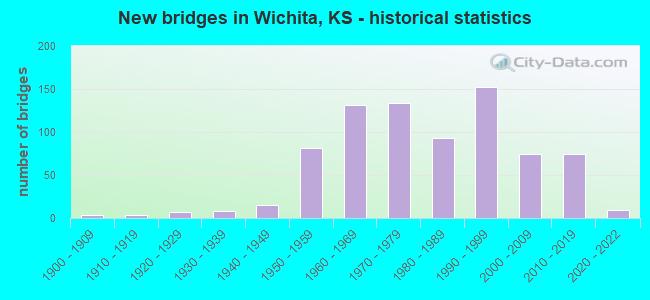
- New bridges - historical statistics
- 41900-1909
- 41910-1919
- 71920-1929
- 81930-1939
- 151940-1949
- 811950-1959
- 1311960-1969
- 1341970-1979
- 931980-1989
- 1521990-1999
- 742000-2009
- 742010-2019
- 92020-2022
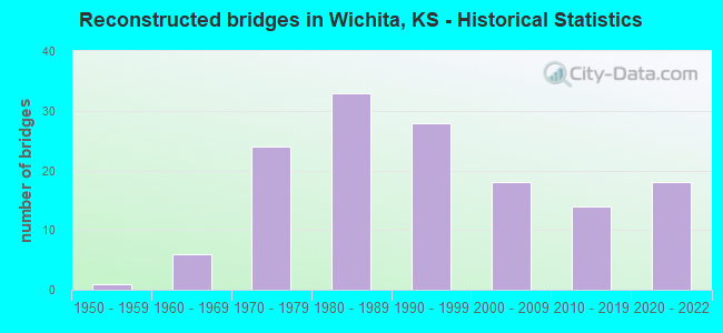
- Reconstructed bridges - Historical Statistics
- 11950-1959
- 61960-1969
- 241970-1979
- 331980-1989
- 281990-1999
- 182000-2009
- 142010-2019
- 182020-2022
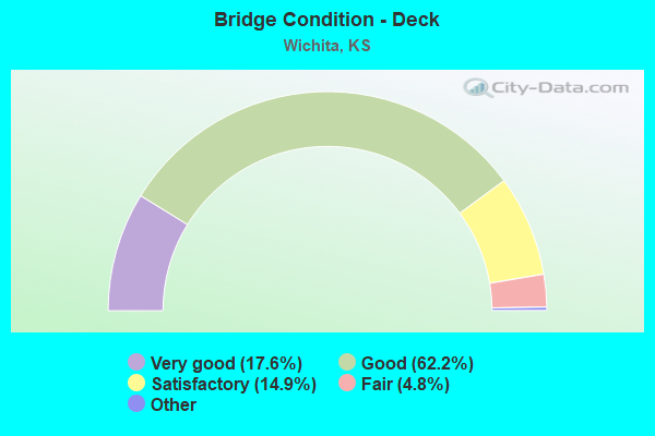
- Bridge Condition - Deck
- 17.6%Very good
- 62.2%Good
- 14.9%Satisfactory
- 4.8%Fair
- 0.5%Poor
- 0.2%Serious
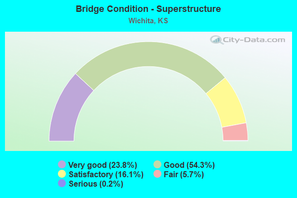
- Bridge Condition - Superstructure
- 23.8%Very good
- 54.3%Good
- 16.1%Satisfactory
- 5.7%Fair
- 0.2%Serious
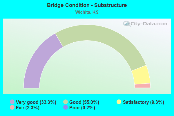
- Bridge Condition - Substructure
- 33.3%Very good
- 55.0%Good
- 9.3%Satisfactory
- 2.3%Fair
- 0.2%Poor
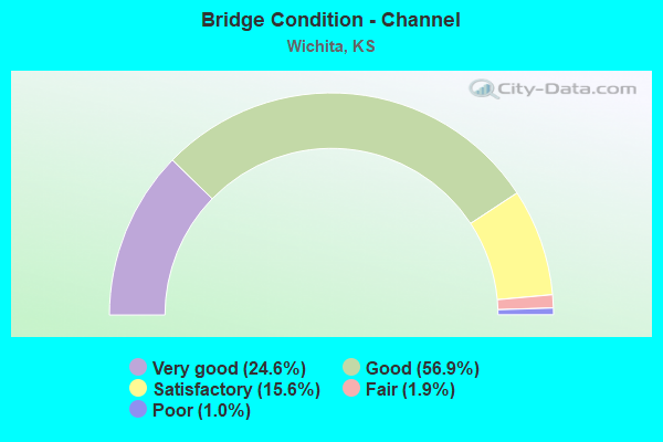
- Bridge Condition - Channel
- 24.6%Very good
- 56.9%Good
- 15.6%Satisfactory
- 1.9%Fair
- 1.0%Poor
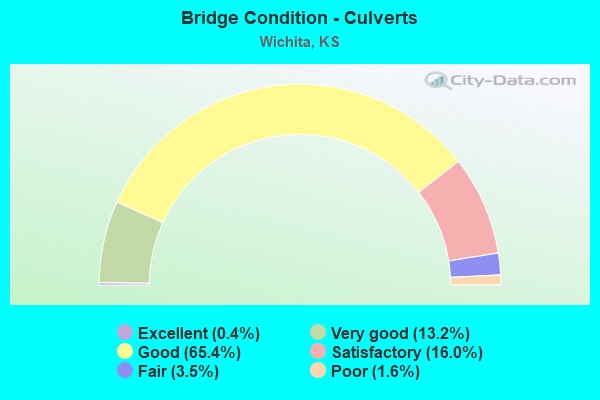
- Bridge Condition - Culverts
- 0.4%Excellent
- 13.2%Very good
- 65.4%Good
- 16.0%Satisfactory
- 3.5%Fair
- 1.6%Poor
Find on map >> Show street view
Structure Number: 999903500872443, Location: 0.66 MI NE K-15 (Lat: 37.635000, Lng: -97.286111), Route carried "on" structure: City street 6100, Year Built: 1956, Year Reconstructed: 1994, Status: Open, Structure Length: 5.44m (17.85ft), Average Daily Traffic: 7,322 (year 2020), Truck Traffic: 5%, Average Future Daily Traffic: 8,759 (year 2041), Design Load: HS 20, Features Intersected: I-35 HWY (KTA), Facility Carried by Structure: THIRTY FIRST ST
Minimum Vertical Clearance: 30.47m (99.97ft), Kilometerpoint: 1.502, Lanes on structure: 4, Lanes under structure: 4, Owner: State Toll Authority, Approaching Roadway Width: 14.6m (47.9ft), Skew: 2 degrees, Material/Design: Steel continuous, Design/Construction: Stringer/Multi-beam, Number Of Spans In Main Unit: 4, Length of Maximum Span: 15.5m (50.9ft), Curb or Sidewalk Widths: Left: 1.8m (5.9ft), Right: 1.8m (5.9ft), Curb-To-Curb Width: 14.6m (47.9ft), Out-to-Out Width: 18.7m (61.4ft)
Condition: Deck: Fair, Superstructure: Good, Substructure: Good, Operating Rating: 40.8 metric tons, Method Used To Determine Operating Rating: Load Factor (LF), Inventory Rating: 24.5 metric tons, Method Used To Determine Inventory Rating: Load Factor (LF), Structural Evaluation: Equal to present minimum criteria, Deck Geometry: High priority of replacement, Underclear: Meets minimum limits, Approach Roadway Alignment: Somewhat better than minimum adequacy, Length Of Structure Improvement: 17.85m (58.56ft), Designated Inspection Frequency: Every 24 months, Inspection Date: July 2021, Wearing Surface/Protective System: Wearing Surface: Latex Concrete
Find on map >> Show street view
Structure Number: 999903500872453, Location: 1.26 MI NE K-15 (Lat: 37.640278, Lng: -97.283056), Route carried "on" structure: ServiceCity street 2267, Year Built: 1956, Status: Open, Structure Length: 4.89m (16.04ft), Average Daily Traffic: 638 (year 2020), Truck Traffic: 1%, Average Future Daily Traffic: 11,628 (year 2041), Features Intersected: I-35 HWY (KTA), Facility Carried by Structure: FEES ST.
Minimum Vertical Clearance: 30.47m (99.97ft), Kilometerpoint: 0.269, Lanes on structure: 2, Lanes under structure: 4, Owner: State Toll Authority, Approaching Roadway Width: 7.3m (24.0ft), Material/Design: Steel continuous, Design/Construction: Girder and Floorbeam System, Number Of Spans In Main Unit: 4, Length of Maximum Span: 14.3m (46.9ft), Curb or Sidewalk Widths: Left: 0.0m, Right: 1.2m (3.9ft), Curb-To-Curb Width: 6.7m (22.0ft), Out-to-Out Width: 8.8m (28.9ft)
Condition: Deck: Very good, Superstructure: Satisfactory, Substructure: Good, Operating Rating: 42.3 metric tons, Method Used To Determine Operating Rating: Load Factor (LF), Inventory Rating: 33.8 metric tons, Method Used To Determine Inventory Rating: Load Factor (LF), Structural Evaluation: Equal to present minimum criteria, Deck Geometry: Meets minimum limits, Underclear: High priority of corrective action, Approach Roadway Alignment: Somewhat better than minimum adequacy, Length Of Structure Improvement: 16.05m (52.66ft), Designated Inspection Frequency: Every 24 months, Critical Feature Inspection Frequency: Every 24 months, Inspection Date: July 2021, Critical Feature Inspection Date: September 2020, Deck Structure Type: Concrete Cast-file-Place, Wearing Surface/Protective System: Wearing Surface: Monolithic Concrete
Find on map >> Show street view
Structure Number: 999903500872463, Location: 1.54 MI NE K-15 (Lat: 37.643056, Lng: -97.280278), Route carried "on" structure: Interstate 35, Year Built: 1956, Year Reconstructed: 1981, Status: Open, Structure Length: 8.95m (29.36ft), Average Daily Traffic: 7,112 (year 2020), Truck Traffic: 23%, Average Future Daily Traffic: 9,963 (year 2041), Design Load: HS 20+Mod, Features Intersected: OLIVER ST
Minimum Vertical Clearance: 30.47m (99.97ft), Kilometerpoint: 20.390, Lanes on structure: 2, Lanes under structure: 6, Base Highway Network: Yes, Toll: On Interstate toll segment, Owner: State Toll Authority, Approaching Roadway Width: 11.0m (36.1ft), Skew: 4 degrees, Material/Design: Steel continuous, Design/Construction: Stringer/Multi-beam, Number Of Spans In Main Unit: 3, Length of Maximum Span: 44.2m (145.0ft), Curb-To-Curb Width: 9.8m (32.2ft), Out-to-Out Width: 10.5m (34.4ft)
Condition: Deck: Good, Superstructure: Good, Substructure: Satisfactory, Operating Rating: 47.8 metric tons, Method Used To Determine Operating Rating: Load Factor (LF), Inventory Rating: 28.7 metric tons, Method Used To Determine Inventory Rating: Load Factor (LF), Structural Evaluation: Equal to present minimum criteria, Deck Geometry: Meets minimum limits, Underclear: Meets minimum limits, Approach Roadway Alignment: Equal to present minimum criteria, Length Of Structure Improvement: 29.35m (96.29ft), Designated Inspection Frequency: Every 24 months, Inspection Date: July 2021, Deck Structure Type: Concrete Cast-file-Place, Wearing Surface/Protective System: Wearing Surface: Monolithic Concrete, Deck Protection: Epoxy Coated Reinforcing
Find on map >> Show street view
Structure Number: 999903500872473, Location: 1.53 MI NE K-15 (Lat: 37.643056, Lng: -97.280278), Route carried "on" structure: Interstate 35, Year Built: 1956, Year Reconstructed: 1981, Status: Open, Structure Length: 8.95m (29.36ft), Average Daily Traffic: 7,112 (year 2020), Truck Traffic: 23%, Average Future Daily Traffic: 9,963 (year 2041), Design Load: HS 20+Mod, Features Intersected: URB6525,6810,OLIVER ST
Minimum Vertical Clearance: 30.47m (99.97ft), Kilometerpoint: 20.371, Lanes on structure: 2, Lanes under structure: 6, Base Highway Network: Yes, Toll: On Interstate toll segment, Owner: State Toll Authority, Approaching Roadway Width: 11.0m (36.1ft), Skew: 4 degrees, Material/Design: Steel continuous, Design/Construction: Stringer/Multi-beam, Number Of Spans In Main Unit: 3, Length of Maximum Span: 44.2m (145.0ft), Curb-To-Curb Width: 9.8m (32.2ft), Out-to-Out Width: 10.5m (34.4ft)
Condition: Deck: Good, Superstructure: Good, Substructure: Good, Operating Rating: 47.8 metric tons, Method Used To Determine Operating Rating: Load Factor (LF), Inventory Rating: 28.7 metric tons, Method Used To Determine Inventory Rating: Load Factor (LF), Structural Evaluation: Better than present minimum criteria, Deck Geometry: Meets minimum limits, Underclear: Meets minimum limits, Approach Roadway Alignment: Equal to present minimum criteria, Length Of Structure Improvement: 29.35m (96.29ft), Designated Inspection Frequency: Every 24 months, Inspection Date: July 2021, Deck Structure Type: Concrete Cast-file-Place, Wearing Surface/Protective System: Wearing Surface: Monolithic Concrete, Deck Protection: Epoxy Coated Reinforcing
Find on map >> Show street view
Structure Number: 999903500872483, Location: 2.20 MI NE K-15 (Lat: 37.650000, Lng: -97.271667), Route carried "on" structure: Interstate 35, Year Built: 1956, Year Reconstructed: 1983, Status: Open, Structure Length: 6.48m (21.26ft), Average Daily Traffic: 7,112 (year 2020), Truck Traffic: 23%, Average Future Daily Traffic: 9,963 (year 2041), Design Load: HS 20+Mod, Features Intersected: URB6250, PAWNEE AVE
Minimum Vertical Clearance: 30.47m (99.97ft), Kilometerpoint: 21.448, Lanes on structure: 2, Lanes under structure: 4, Base Highway Network: Yes, Toll: On Interstate toll segment, Owner: State Toll Authority, Approaching Roadway Width: 11.0m (36.1ft), Skew: 3 degrees, Material/Design: Steel continuous, Design/Construction: Stringer/Multi-beam, Number Of Spans In Main Unit: 3, Length of Maximum Span: 28.7m (94.2ft), Curb-To-Curb Width: 9.8m (32.2ft), Out-to-Out Width: 10.5m (34.4ft)
Condition: Deck: Good, Superstructure: Good, Substructure: Good, Operating Rating: 55.3 metric tons, Method Used To Determine Operating Rating: Load Factor (LF), Inventory Rating: 33.2 metric tons, Method Used To Determine Inventory Rating: Load Factor (LF), Structural Evaluation: Better than present minimum criteria, Deck Geometry: Meets minimum limits, Underclear: High priority of corrective action, Approach Roadway Alignment: Equal to present minimum criteria, Length Of Structure Improvement: 21.25m (69.72ft), Designated Inspection Frequency: Every 24 months, Inspection Date: July 2021, Deck Structure Type: Concrete Cast-file-Place, Wearing Surface/Protective System: Wearing Surface: Epoxy Overlay, Deck Protection: Epoxy Coated Reinforcing
Find on map >> Show street view
Structure Number: 999903500872493, Location: 2.21 MI NE K-15 (Lat: 37.650000, Lng: -97.271667), Route carried "on" structure: Interstate 35, Year Built: 1956, Year Reconstructed: 1983, Status: Open, Structure Length: 6.48m (21.26ft), Average Daily Traffic: 7,112 (year 2020), Truck Traffic: 23%, Average Future Daily Traffic: 9,963 (year 2041), Design Load: HS 20+Mod, Features Intersected: PAWNEE AVE
Minimum Vertical Clearance: 30.47m (99.97ft), Kilometerpoint: 21.451, Lanes on structure: 2, Lanes under structure: 4, Base Highway Network: Yes, Toll: On Interstate toll segment, Owner: State Toll Authority, Approaching Roadway Width: 11.0m (36.1ft), Skew: 3 degrees, Material/Design: Steel continuous, Design/Construction: Stringer/Multi-beam, Number Of Spans In Main Unit: 3, Length of Maximum Span: 28.7m (94.2ft), Curb-To-Curb Width: 9.8m (32.2ft), Out-to-Out Width: 10.5m (34.4ft)
Condition: Deck: Good, Superstructure: Good, Substructure: Good, Operating Rating: 55.3 metric tons, Method Used To Determine Operating Rating: Load Factor (LF), Inventory Rating: 33.2 metric tons, Method Used To Determine Inventory Rating: Load Factor (LF), Structural Evaluation: Better than present minimum criteria, Deck Geometry: Meets minimum limits, Underclear: High priority of corrective action, Approach Roadway Alignment: Equal to present minimum criteria, Length Of Structure Improvement: 21.25m (69.72ft), Designated Inspection Frequency: Every 24 months, Inspection Date: July 2021, Deck Structure Type: Concrete Cast-file-Place, Wearing Surface/Protective System: Wearing Surface: Epoxy Overlay, Deck Protection: Epoxy Coated Reinforcing
Find on map >> Show street view
Structure Number: 999903500872503, Location: 2.87 MI NE K-15 (Lat: 37.655833, Lng: -97.261944), Route carried "on" structure: Interstate 35, Year Built: 1956, Year Reconstructed: 1983, Status: Open, Structure Length: 4.80m (15.75ft), Average Daily Traffic: 7,112 (year 2020), Truck Traffic: 23%, Average Future Daily Traffic: 9,963 (year 2041), Design Load: HS 20+Mod, Features Intersected: WOODLAWN BOULEVARD
Minimum Vertical Clearance: 30.47m (99.97ft), Kilometerpoint: 22.534, Lanes on structure: 2, Lanes under structure: 4, Base Highway Network: Yes, Toll: On Interstate toll segment, Owner: State Toll Authority, Approaching Roadway Width: 11.0m (36.1ft), Skew: 3 degrees, Material/Design: Steel continuous, Design/Construction: Stringer/Multi-beam, Number Of Spans In Main Unit: 3, Length of Maximum Span: 21.0m (68.9ft), Curb-To-Curb Width: 9.8m (32.2ft), Out-to-Out Width: 10.5m (34.4ft)
Condition: Deck: Good, Superstructure: Good, Substructure: Good, Operating Rating: 59.3 metric tons, Method Used To Determine Operating Rating: Load Factor (LF), Inventory Rating: 35.6 metric tons, Method Used To Determine Inventory Rating: Load Factor (LF), Structural Evaluation: Better than present minimum criteria, Deck Geometry: High priority of replacement, Underclear: High priority of corrective action, Approach Roadway Alignment: Equal to present minimum criteria, Length Of Structure Improvement: 15.75m (51.67ft), Designated Inspection Frequency: Every 24 months, Inspection Date: July 2021, Deck Structure Type: Concrete Cast-file-Place, Wearing Surface/Protective System: Wearing Surface: Epoxy Overlay, Deck Protection: Epoxy Coated Reinforcing
Find on map >> Show street view
Structure Number: 999903500872513, Location: 2.88 MI NE K-15 (Lat: 37.655833, Lng: -97.261944), Route carried "on" structure: Interstate 35, Year Built: 1956, Year Reconstructed: 1983, Status: Open, Structure Length: 4.80m (15.75ft), Average Daily Traffic: 7,112 (year 2020), Truck Traffic: 23%, Average Future Daily Traffic: 9,963 (year 2041), Design Load: HS 20+Mod, Features Intersected: WOODLAWN BOULEVARD
Minimum Vertical Clearance: 30.47m (99.97ft), Kilometerpoint: 22.512, Lanes on structure: 2, Lanes under structure: 4, Base Highway Network: Yes, Toll: On Interstate toll segment, Owner: State Toll Authority, Approaching Roadway Width: 11.0m (36.1ft), Skew: 3 degrees, Material/Design: Steel continuous, Design/Construction: Stringer/Multi-beam, Number Of Spans In Main Unit: 3, Length of Maximum Span: 21.0m (68.9ft), Curb-To-Curb Width: 9.8m (32.2ft), Out-to-Out Width: 10.5m (34.4ft)
Condition: Deck: Good, Superstructure: Good, Substructure: Good, Operating Rating: 59.3 metric tons, Method Used To Determine Operating Rating: Load Factor (LF), Inventory Rating: 35.6 metric tons, Method Used To Determine Inventory Rating: Load Factor (LF), Structural Evaluation: Better than present minimum criteria, Deck Geometry: High priority of replacement, Underclear: High priority of corrective action, Approach Roadway Alignment: Equal to present minimum criteria, Length Of Structure Improvement: 15.75m (51.67ft), Designated Inspection Frequency: Every 24 months, Inspection Date: July 2021, Deck Structure Type: Concrete Cast-file-Place, Wearing Surface/Protective System: Wearing Surface: Epoxy Overlay, Deck Protection: Epoxy Coated Reinforcing
Find on map >> Show street view
Structure Number: 999903500872523, Location: 3.76 MI NE K-15 (Lat: 37.664444, Lng: -97.250278), Route carried "on" structure: Interstate 35, Year Built: 1956, Year Reconstructed: 1981, Status: Open, Structure Length: 5.14m (16.86ft), Average Daily Traffic: 7,112 (year 2020), Truck Traffic: 23%, Average Future Daily Traffic: 9,963 (year 2041), Design Load: HS 20+Mod, Features Intersected: HARRY STREET
Minimum Vertical Clearance: 30.47m (99.97ft), Kilometerpoint: 23.958, Lanes on structure: 2, Lanes under structure: 4, Base Highway Network: Yes, Toll: On Interstate toll segment, Owner: State Toll Authority, Approaching Roadway Width: 11.0m (36.1ft), Skew: 5 degrees, Material/Design: Steel continuous, Design/Construction: Stringer/Multi-beam, Number Of Spans In Main Unit: 3, Length of Maximum Span: 22.6m (74.1ft), Curb-To-Curb Width: 9.8m (32.2ft), Out-to-Out Width: 10.5m (34.4ft)
Condition: Deck: Good, Superstructure: Good, Substructure: Good, Operating Rating: 56.6 metric tons, Method Used To Determine Operating Rating: Load Factor (LF), Inventory Rating: 33.9 metric tons, Method Used To Determine Inventory Rating: Load Factor (LF), Structural Evaluation: Better than present minimum criteria, Deck Geometry: High priority of replacement, Underclear: High priority of corrective action, Approach Roadway Alignment: Equal to present minimum criteria, Length Of Structure Improvement: 16.85m (55.28ft), Designated Inspection Frequency: Every 24 months, Inspection Date: July 2021, Deck Structure Type: Concrete Cast-file-Place, Wearing Surface/Protective System: Wearing Surface: Epoxy Overlay, Deck Protection: Epoxy Coated Reinforcing
Find on map >> Show street view
Structure Number: 999903500872533, Location: 3.77 MI NE K-15 (Lat: 37.664444, Lng: -97.250278), Route carried "on" structure: Interstate 35, Year Built: 1956, Year Reconstructed: 1981, Status: Open, Structure Length: 5.14m (16.86ft), Average Daily Traffic: 7,112 (year 2020), Truck Traffic: 23%, Average Future Daily Traffic: 9,963 (year 2041), Design Load: HS 20+Mod, Features Intersected: HARRY STREET
Minimum Vertical Clearance: 30.47m (99.97ft), Kilometerpoint: 23.955, Lanes on structure: 2, Lanes under structure: 4, Base Highway Network: Yes, Toll: On Interstate toll segment, Owner: State Toll Authority, Approaching Roadway Width: 11.0m (36.1ft), Skew: 5 degrees, Material/Design: Steel continuous, Design/Construction: Stringer/Multi-beam, Number Of Spans In Main Unit: 3, Length of Maximum Span: 22.6m (74.1ft), Curb-To-Curb Width: 9.8m (32.2ft), Out-to-Out Width: 10.5m (34.4ft)
Condition: Deck: Good, Superstructure: Good, Substructure: Good, Operating Rating: 56.6 metric tons, Method Used To Determine Operating Rating: Load Factor (LF), Inventory Rating: 33.9 metric tons, Method Used To Determine Inventory Rating: Load Factor (LF), Structural Evaluation: Better than present minimum criteria, Deck Geometry: High priority of replacement, Underclear: High priority of corrective action, Approach Roadway Alignment: Equal to present minimum criteria, Length Of Structure Improvement: 16.85m (55.28ft), Designated Inspection Frequency: Every 24 months, Inspection Date: July 2021, Deck Structure Type: Concrete Cast-file-Place, Wearing Surface/Protective System: Wearing Surface: Epoxy Overlay, Deck Protection: Epoxy Coated Reinforcing
Find on map >> Show street view
Structure Number: 999903500872543, Location: 4.23 MI NE K-15 (Lat: 37.669167, Lng: -97.244167), Route carried "on" structure: Interstate 35, Year Built: 1956, Year Reconstructed: 1981, Status: Open, Structure Length: 4.53m (14.86ft), Average Daily Traffic: 7,112 (year 2020), Truck Traffic: 23%, Average Future Daily Traffic: 9,963 (year 2041), Design Load: HS 20+Mod, Features Intersected: ROCK ROAD
Minimum Vertical Clearance: 30.47m (99.97ft), Kilometerpoint: 24.711, Lanes on structure: 2, Lanes under structure: 4, Base Highway Network: Yes, Toll: On Interstate toll segment, Owner: State Toll Authority, Approaching Roadway Width: 11.0m (36.1ft), Skew: 3 degrees, Material/Design: Steel continuous, Design/Construction: Stringer/Multi-beam, Number Of Spans In Main Unit: 3, Length of Maximum Span: 19.8m (65.0ft), Curb-To-Curb Width: 9.8m (32.2ft), Out-to-Out Width: 10.5m (34.4ft)
Condition: Deck: Good, Superstructure: Good, Substructure: Good, Operating Rating: 60.9 metric tons, Method Used To Determine Operating Rating: Load Factor (LF), Inventory Rating: 36.6 metric tons, Method Used To Determine Inventory Rating: Load Factor (LF), Structural Evaluation: Better than present minimum criteria, Deck Geometry: High priority of replacement, Underclear: High priority of corrective action, Approach Roadway Alignment: Equal to present minimum criteria, Length Of Structure Improvement: 14.85m (48.72ft), Designated Inspection Frequency: Every 24 months, Inspection Date: July 2021, Deck Structure Type: Concrete Cast-file-Place, Wearing Surface/Protective System: Wearing Surface: Epoxy Overlay, Deck Protection: Epoxy Coated Reinforcing
Find on map >> Show street view
Structure Number: 999903500872553, Location: 4.22 MI NE K-15 (Lat: 37.669167, Lng: -97.244167), Route carried "on" structure: Interstate 35, Year Built: 1956, Year Reconstructed: 1981, Status: Open, Structure Length: 4.53m (14.86ft), Average Daily Traffic: 7,112 (year 2020), Truck Traffic: 23%, Average Future Daily Traffic: 9,963 (year 2041), Design Load: HS 20+Mod, Features Intersected: ROCK ROAD
Minimum Vertical Clearance: 30.47m (99.97ft), Kilometerpoint: 24.691, Lanes on structure: 2, Lanes under structure: 4, Base Highway Network: Yes, Toll: On Interstate toll segment, Owner: State Toll Authority, Approaching Roadway Width: 11.0m (36.1ft), Skew: 3 degrees, Material/Design: Steel continuous, Design/Construction: Stringer/Multi-beam, Number Of Spans In Main Unit: 3, Length of Maximum Span: 19.8m (65.0ft), Curb-To-Curb Width: 9.8m (32.2ft), Out-to-Out Width: 10.5m (34.4ft)
Condition: Deck: Good, Superstructure: Good, Substructure: Good, Operating Rating: 60.9 metric tons, Method Used To Determine Operating Rating: Load Factor (LF), Inventory Rating: 36.6 metric tons, Method Used To Determine Inventory Rating: Load Factor (LF), Structural Evaluation: Better than present minimum criteria, Deck Geometry: High priority of replacement, Underclear: High priority of corrective action, Approach Roadway Alignment: Equal to present minimum criteria, Length Of Structure Improvement: 14.85m (48.72ft), Designated Inspection Frequency: Every 24 months, Inspection Date: July 2021, Deck Structure Type: Concrete Cast-file-Place, Wearing Surface/Protective System: Wearing Surface: Epoxy Overlay, Deck Protection: Epoxy Coated Reinforcing
Find on map >> Show street view
Structure Number: 999903500872563, Location: US-54 / I-35 INTERCHANGE (Lat: 37.675000, Lng: -97.230000), Route carried "on" structure: Ramp State highway 4, Year Built: 1956, Status: Open, Structure Length: 5.29m (17.36ft), Average Daily Traffic: 4,810 (year 2020), Truck Traffic: 5%, Average Future Daily Traffic: 13,099 (year 2041), Features Intersected: I-35 HWY (KTA)
Minimum Vertical Clearance: 30.47m (99.97ft), Kilometerpoint: 0.179, Lanes on structure: 2, Lanes under structure: 4, Owner: State Toll Authority, Approaching Roadway Width: 14.6m (47.9ft), Skew: 20 degrees, Material/Design: Steel continuous, Design/Construction: Stringer/Multi-beam, Number Of Spans In Main Unit: 4, Length of Maximum Span: 18.0m (59.1ft), Curb-To-Curb Width: 10.9m (35.8ft), Out-to-Out Width: 12.6m (41.3ft)
Condition: Deck: Good, Superstructure: Good, Substructure: Good, Operating Rating: 71.2 metric tons, Method Used To Determine Operating Rating: Load Factor (LF), Inventory Rating: 38.6 metric tons, Method Used To Determine Inventory Rating: Load Factor (LF), Structural Evaluation: Better than present minimum criteria, Deck Geometry: Better than present minimum criteria, Underclear: High priority of corrective action, Approach Roadway Alignment: Somewhat better than minimum adequacy, Length Of Structure Improvement: 17.35m (56.92ft), Designated Inspection Frequency: Every 24 months, Inspection Date: June 2021, Deck Structure Type: Concrete Cast-file-Place, Wearing Surface/Protective System: Wearing Surface: Monolithic Concrete
Find on map >> Show street view
Structure Number: 999903500872573, Location: 2.04 MI SW US-54 (Lat: 37.675000, Lng: -97.226111), Route carried "on" structure: City street 6675, Year Built: 1956, Status: Open, Structure Length: 4.92m (16.14ft), Average Daily Traffic: 10,563 (year 2020), Truck Traffic: 15%, Average Future Daily Traffic: 15,696 (year 2041), Design Load: HS 20, Features Intersected: I-35 HWY (KTA)
Minimum Vertical Clearance: 30.47m (99.97ft), Kilometerpoint: 4.403, Lanes on structure: 4, Lanes under structure: 4, Owner: State Toll Authority, Approaching Roadway Width: 14.6m (47.9ft), Material/Design: Steel continuous, Design/Construction: Stringer/Multi-beam, Number Of Spans In Main Unit: 4, Length of Maximum Span: 14.0m (45.9ft), Curb or Sidewalk Widths: Left: 1.8m (5.9ft), Right: 1.8m (5.9ft), Curb-To-Curb Width: 14.6m (47.9ft), Out-to-Out Width: 16.2m (53.1ft)
Condition: Deck: Good, Superstructure: Good, Substructure: Good, Operating Rating: 80.5 metric tons, Method Used To Determine Operating Rating: Load Factor (LF), Inventory Rating: 41.6 metric tons, Method Used To Determine Inventory Rating: Load Factor (LF), Structural Evaluation: Better than present minimum criteria, Deck Geometry: High priority of replacement, Underclear: Meets minimum limits, Approach Roadway Alignment: Somewhat better than minimum adequacy, Length Of Structure Improvement: 16.15m (52.99ft), Designated Inspection Frequency: Every 24 months, Inspection Date: June 2021, Deck Structure Type: Concrete Cast-file-Place, Wearing Surface/Protective System: Wearing Surface: Monolithic Concrete
Find on map >> Show street view
Structure Number: 999903500872583, Location: 1.04 MI SW US-54 (Lat: 37.675000, Lng: -97.207778), Route carried "on" structure: Interstate 35, Year Built: 1956, Year Reconstructed: 1980, Status: Open, Structure Length: 3.86m (12.66ft), Average Daily Traffic: 7,876 (year 2020), Truck Traffic: 24%, Average Future Daily Traffic: 11,034 (year 2041), Design Load: HS 20+Mod, Features Intersected: URB6725, GREENWICH RD
Minimum Vertical Clearance: 30.47m (99.97ft), Kilometerpoint: 28.102, Lanes on structure: 2, Lanes under structure: 2, Base Highway Network: Yes, Toll: On Interstate toll segment, Owner: State Toll Authority, Approaching Roadway Width: 11.0m (36.1ft), Material/Design: Steel continuous, Design/Construction: Stringer/Multi-beam, Number Of Spans In Main Unit: 3, Length of Maximum Span: 16.8m (55.1ft), Curb-To-Curb Width: 9.8m (32.2ft), Out-to-Out Width: 10.5m (34.4ft)
Condition: Deck: Good, Superstructure: Satisfactory, Substructure: Good, Operating Rating: 55.9 metric tons, Method Used To Determine Operating Rating: Load Factor (LF), Inventory Rating: 33.6 metric tons, Method Used To Determine Inventory Rating: Load Factor (LF), Structural Evaluation: Equal to present minimum criteria, Deck Geometry: High priority of replacement, Underclear: Equal to present minimum criteria, Approach Roadway Alignment: Equal to present minimum criteria, Length Of Structure Improvement: 12.65m (41.50ft), Designated Inspection Frequency: Every 24 months, Inspection Date: June 2021, Deck Structure Type: Concrete Cast-file-Place, Wearing Surface/Protective System: Wearing Surface: Epoxy Overlay, Deck Protection: Epoxy Coated Reinforcing
Find on map >> Show street view
Structure Number: 999903500872593, Location: 1.05 MI SW US-54 (Lat: 37.675000, Lng: -97.207778), Route carried "on" structure: Interstate 35, Year Built: 1956, Year Reconstructed: 1980, Status: Open, Structure Length: 3.86m (12.66ft), Average Daily Traffic: 7,876 (year 2020), Truck Traffic: 24%, Average Future Daily Traffic: 11,034 (year 2041), Design Load: HS 20+Mod, Features Intersected: GREENWICH RD
Minimum Vertical Clearance: 30.47m (99.97ft), Kilometerpoint: 28.081, Lanes on structure: 2, Lanes under structure: 4, Base Highway Network: Yes, Toll: On Interstate toll segment, Owner: State Toll Authority, Approaching Roadway Width: 11.0m (36.1ft), Material/Design: Steel continuous, Design/Construction: Stringer/Multi-beam, Number Of Spans In Main Unit: 3, Length of Maximum Span: 16.8m (55.1ft), Curb-To-Curb Width: 9.8m (32.2ft), Out-to-Out Width: 10.5m (34.4ft)
Condition: Deck: Good, Superstructure: Satisfactory, Substructure: Good, Operating Rating: 55.9 metric tons, Method Used To Determine Operating Rating: Load Factor (LF), Inventory Rating: 33.6 metric tons, Method Used To Determine Inventory Rating: Load Factor (LF), Structural Evaluation: Equal to present minimum criteria, Deck Geometry: High priority of replacement, Underclear: Equal to present minimum criteria, Approach Roadway Alignment: Equal to present minimum criteria, Length Of Structure Improvement: 12.65m (41.50ft), Designated Inspection Frequency: Every 24 months, Inspection Date: June 2021, Deck Structure Type: Concrete Cast-file-Place, Wearing Surface/Protective System: Wearing Surface: Epoxy Overlay, Deck Protection: Epoxy Coated Reinforcing
Find on map >> Show street view
Structure Number: 999903500873573, Location: 0.75 MI NE US-54 (Lat: 37.686667, Lng: -97.180556), Route carried "on" structure: Ramp State highway 5, Year Built: 1994, Status: Open, Structure Length: 6.39m (20.96ft), Average Daily Traffic: 1,570 (year 2020), Truck Traffic: 5%, Average Future Daily Traffic: 10,517 (year 2041), Design Load: HS 25 or greater, Features Intersected: I-35 HWY (KTA), Facility Carried by Structure: KTA ACCESS ROAD
Minimum Vertical Clearance: 30.47m (99.97ft), Kilometerpoint: 0.502, Lanes on structure: 2, Lanes under structure: 4, Owner: State Toll Authority, Approaching Roadway Width: 11.7m (38.4ft), Skew: 20 degrees, Material/Design: Prestressed concrete continuous, Design/Construction: Stringer/Multi-beam, Number Of Spans In Main Unit: 2, Length of Maximum Span: 31.5m (103.3ft), Curb-To-Curb Width: 11.7m (38.4ft), Out-to-Out Width: 12.6m (41.3ft)
Condition: Deck: Good, Superstructure: Good, Substructure: Good, Operating Rating: 59.6 metric tons, Method Used To Determine Operating Rating: Load Factor (LF), Inventory Rating: 20.3 metric tons, Method Used To Determine Inventory Rating: Load Factor (LF), Structural Evaluation: Somewhat better than minimum adequacy, Deck Geometry: Superior to present desirable criteria, Underclear: High priority of corrective action, Approach Roadway Alignment: Somewhat better than minimum adequacy, Length Of Structure Improvement: 20.95m (68.73ft), Designated Inspection Frequency: Every 24 months, Inspection Date: July 2021, Wearing Surface/Protective System: Wearing Surface: Monolithic Concrete
Find on map >> Show street view
Structure Number: 999903500873703, Location: 4.10 MI N K15 (Lat: 37.668056, Lng: -97.246667), Route carried "on" structure: Interstate 35, Year Built: 1955, Status: Open, Structure Length: 0.94m (3.08ft), Average Daily Traffic: 7,112 (year 2020), Truck Traffic: 23%, Average Future Daily Traffic: 9,963 (year 2041), Design Load: H 20, Features Intersected: GYPSUM CREEK
Minimum Vertical Clearance: 30.47m (99.97ft), Kilometerpoint: 24.460, Lanes on structure: 4, Base Highway Network: Yes, Toll: On Interstate toll segment, Owner: State Toll Authority, Approaching Roadway Width: 27.4m (89.9ft), Skew: 30 degrees, Material/Design: Concrete, Design/Construction: Culvert, Number Of Spans In Main Unit: 3, Length of Maximum Span: 3.0m (9.8ft), Curb-To-Curb Width: 27.4m (89.9ft), Out-to-Out Width: 56.1m (184.1ft)
Condition: Channel: Satisfactory, Culverts: Satisfactory, Operating Rating: 89.8 metric tons, Method Used To Determine Operating Rating: Load Factor (LF), Inventory Rating: 89.8 metric tons, Method Used To Determine Inventory Rating: Load Factor (LF), Structural Evaluation: Equal to present minimum criteria, Deck Geometry: Superior to present desirable criteria, Waterway Adequacy: Equal to present minimum criteria, Approach Roadway Alignment: Equal to present desirable criteria, Length Of Structure Improvement: 3.10m (10.17ft), Designated Inspection Frequency: Every 24 months, Inspection Date: July 2021, Deck Structure Type: Concrete Cast-file-Place, Wearing Surface/Protective System: Wearing Surface: Bituminous
Find on map >> Show street view
Structure Number: 999903500873713, Location: 0.60 MI NE US54 (Lat: 37.684167, Lng: -97.184722), Route carried "on" structure: Interstate 35, Year Built: 1955, Year Reconstructed: 1993, Status: Open, Structure Length: 0.63m (2.07ft), Average Daily Traffic: 7,254 (year 2020), Truck Traffic: 26%, Average Future Daily Traffic: 9,028 (year 2041), Design Load: H 20, Features Intersected: DRAINAGE CHANNEL
Minimum Vertical Clearance: 30.47m (99.97ft), Kilometerpoint: 30.531, Lanes on structure: 4, Base Highway Network: Yes, Toll: On Interstate toll segment, Owner: State Toll Authority, Approaching Roadway Width: 28.7m (94.2ft), Skew: 20 degrees, Material/Design: Concrete, Design/Construction: Culvert, Number Of Spans In Main Unit: 2, Length of Maximum Span: 3.0m (9.8ft), Curb-To-Curb Width: 28.7m (94.2ft), Out-to-Out Width: 42.8m (140.4ft)
Condition: Channel: Good, Culverts: Good, Operating Rating: 65.3 metric tons, Method Used To Determine Operating Rating: Load Factor (LF), Inventory Rating: 39.0 metric tons, Method Used To Determine Inventory Rating: Load Factor (LF), Structural Evaluation: Better than present minimum criteria, Deck Geometry: Superior to present desirable criteria, Waterway Adequacy: Equal to present desirable criteria, Approach Roadway Alignment: Equal to present desirable criteria, Length Of Structure Improvement: 2.06m (6.76ft), Designated Inspection Frequency: Every 24 months, Inspection Date: June 2021, Deck Structure Type: Concrete Cast-file-Place, Wearing Surface/Protective System: Wearing Surface: Bituminous
Find on map >> Show street view
Structure Number: 999903500873723, Location: 1.50 MI NE US54 (Lat: 37.693333, Lng: -97.169167), Route carried "on" structure: Interstate 35, Year Built: 1955, Status: Open, Structure Length: 1.41m (4.63ft), Average Daily Traffic: 7,254 (year 2020), Truck Traffic: 26%, Average Future Daily Traffic: 9,028 (year 2041), Design Load: H 20, Features Intersected: FOUR MILE CREEK
Minimum Vertical Clearance: 30.47m (99.97ft), Kilometerpoint: 32.222, Lanes on structure: 8, Base Highway Network: Yes, Toll: On Interstate toll segment, Owner: State Toll Authority, Approaching Roadway Width: 27.4m (89.9ft), Skew: 32 degrees, Material/Design: Concrete, Design/Construction: Culvert, Number Of Spans In Main Unit: 3, Length of Maximum Span: 4.3m (14.1ft), Curb or Sidewalk Widths: Left: 1.2m (3.9ft), Right: 0.0m, Curb-To-Curb Width: 27.4m (89.9ft), Out-to-Out Width: 76.2m (250.0ft)
Condition: Channel: Good, Culverts: Fair, Operating Rating: 89.8 metric tons, Method Used To Determine Operating Rating: Load Factor (LF), Inventory Rating: 89.8 metric tons, Method Used To Determine Inventory Rating: Load Factor (LF), Structural Evaluation: Somewhat better than minimum adequacy, Deck Geometry: High priority of replacement, Waterway Adequacy: Equal to present desirable criteria, Approach Roadway Alignment: Equal to present desirable criteria, Length Of Structure Improvement: 4.64m (15.22ft), Designated Inspection Frequency: Every 24 months, Inspection Date: July 2021, Deck Structure Type: Concrete Cast-file-Place, Wearing Surface/Protective System: Wearing Surface: Bituminous
Find on map >> Show street view
Structure Number: 999903500873733, Location: 2.20 MI NE US54 (Lat: 37.699167, Lng: -97.158333), Route carried "on" structure: Interstate 35, Year Built: 1955, Status: Open, Structure Length: 0.63m (2.07ft), Average Daily Traffic: 7,254 (year 2020), Truck Traffic: 26%, Average Future Daily Traffic: 9,028 (year 2041), Design Load: H 20, Features Intersected: SPRING CREEK TRIBUTARY
Minimum Vertical Clearance: 30.47m (99.97ft), Kilometerpoint: 33.383, Lanes on structure: 4, Base Highway Network: Yes, Toll: On Interstate toll segment, Owner: State Toll Authority, Approaching Roadway Width: 27.4m (89.9ft), Skew: 30 degrees, Material/Design: Concrete, Design/Construction: Culvert, Number Of Spans In Main Unit: 2, Length of Maximum Span: 3.0m (9.8ft), Curb-To-Curb Width: 27.4m (89.9ft), Out-to-Out Width: 36.6m (120.1ft)
Condition: Channel: Satisfactory, Culverts: Good, Operating Rating: 35.4 metric tons, Method Used To Determine Operating Rating: Load Factor (LF), Inventory Rating: 22.7 metric tons, Method Used To Determine Inventory Rating: Load Factor (LF), Structural Evaluation: Somewhat better than minimum adequacy, Deck Geometry: Superior to present desirable criteria, Waterway Adequacy: Equal to present minimum criteria, Approach Roadway Alignment: Equal to present desirable criteria, Length Of Structure Improvement: 2.06m (6.76ft), Designated Inspection Frequency: Every 24 months, Inspection Date: July 2021, Deck Structure Type: Concrete Cast-file-Place, Wearing Surface/Protective System: Wearing Surface: Bituminous
Find on map >> Show street view
Structure Number: 999903500877843, Location: 1.61 MI NE US-54 (Lat: 37.693889, Lng: -97.168333), Route carried "on" structure: Interstate 35, Year Built: 2002, Status: Open, Structure Length: 7.68m (25.20ft), Average Daily Traffic: 7,254 (year 2020), Truck Traffic: 26%, Average Future Daily Traffic: 9,028 (year 2041), Design Load: HS 20, Features Intersected: CENTRAL AVE
Minimum Vertical Clearance: 30.47m (99.97ft), Kilometerpoint: 32.320, Lanes on structure: 2, Lanes under structure: 5, Base Highway Network: Yes, Toll: On Interstate toll segment, Owner: State Toll Authority, Approaching Roadway Width: 12.2m (40.0ft), Skew: 5 degrees, Material/Design: Steel continuous, Design/Construction: Stringer/Multi-beam, Number Of Spans In Main Unit: 3, Length of Maximum Span: 34.1m (111.9ft), Curb-To-Curb Width: 12.1m (39.7ft), Out-to-Out Width: 12.9m (42.3ft)
Condition: Deck: Good, Superstructure: Good, Substructure: Very good, Operating Rating: 85.3 metric tons, Method Used To Determine Operating Rating: Load Factor (LF), Inventory Rating: 51.1 metric tons, Method Used To Determine Inventory Rating: Load Factor (LF), Structural Evaluation: Better than present minimum criteria, Deck Geometry: Equal to present minimum criteria, Underclear: Better than present minimum criteria, Approach Roadway Alignment: Equal to present desirable criteria, Length Of Structure Improvement: 25.19m (82.64ft), Designated Inspection Frequency: Every 24 months, Inspection Date: July 2021, Wearing Surface/Protective System: Wearing Surface: Epoxy Overlay, Deck Protection: Epoxy Coated Reinforcing
Find on map >> Show street view
Structure Number: 999903500877853, Location: 1.60 MI NE US-54 (Lat: 37.693889, Lng: -97.168333), Route carried "on" structure: Interstate 35, Year Built: 2002, Status: Open, Structure Length: 7.68m (25.20ft), Average Daily Traffic: 7,254 (year 2020), Truck Traffic: 26%, Average Future Daily Traffic: 9,028 (year 2041), Design Load: HS 20, Features Intersected: CENTRAL AVE
Minimum Vertical Clearance: 30.47m (99.97ft), Kilometerpoint: 32.312, Lanes on structure: 2, Lanes under structure: 4, Base Highway Network: Yes, Toll: On Interstate toll segment, Owner: State Toll Authority, Approaching Roadway Width: 12.2m (40.0ft), Skew: 5 degrees, Material/Design: Steel continuous, Design/Construction: Stringer/Multi-beam, Number Of Spans In Main Unit: 3, Length of Maximum Span: 34.1m (111.9ft), Curb-To-Curb Width: 12.1m (39.7ft), Out-to-Out Width: 12.9m (42.3ft)
Condition: Deck: Good, Superstructure: Good, Substructure: Very good, Operating Rating: 85.3 metric tons, Method Used To Determine Operating Rating: Load Factor (LF), Inventory Rating: 51.1 metric tons, Method Used To Determine Inventory Rating: Load Factor (LF), Structural Evaluation: Better than present minimum criteria, Deck Geometry: Equal to present minimum criteria, Underclear: Better than present minimum criteria, Approach Roadway Alignment: Equal to present desirable criteria, Length Of Structure Improvement: 25.19m (82.64ft), Designated Inspection Frequency: Every 24 months, Inspection Date: July 2021, Wearing Surface/Protective System: Wearing Surface: Epoxy Overlay, Deck Protection: Epoxy Coated Reinforcing
Find on map >> Show street view
Structure Number: 999903500877973, Location: 143ST OV KTA BTN U54&CENT (Lat: 37.691944, Lng: -97.171111), Route carried "on" structure: County highway 6745, Year Built: 2011, Status: Open, Structure Length: 9.05m (29.69ft), Average Daily Traffic: 4,283 (year 2020), Truck Traffic: 5%, Average Future Daily Traffic: 6,364 (year 2041), Design Load: HL 93, Features Intersected: KS TURNPIKE SB/NB, Facility Carried by Structure: 143 ST OVR KTA S/N
Minimum Vertical Clearance: 30.47m (99.97ft), Kilometerpoint: 6.264, Lanes on structure: 5, Lanes under structure: 4, Owner: State Toll Authority, Approaching Roadway Width: 18.3m (60.0ft), Skew: 3 degrees, Material/Design: Steel continuous, Design/Construction: Stringer/Multi-beam, Number Of Spans In Main Unit: 4, Length of Maximum Span: 27.9m (91.5ft), Curb or Sidewalk Widths: Left: 0.0m, Right: 1.5m (4.9ft), Curb-To-Curb Width: 18.3m (60.0ft), Out-to-Out Width: 20.9m (68.6ft)
Condition: Deck: Good, Superstructure: Very good, Substructure: Very good, Operating Rating: 62.4 metric tons, Method Used To Determine Operating Rating: Load Factor (LF), Inventory Rating: 37.2 metric tons, Method Used To Determine Inventory Rating: Load Factor (LF), Structural Evaluation: Equal to present desirable criteria, Deck Geometry: High priority of replacement, Underclear: Meets minimum limits, Approach Roadway Alignment: Somewhat better than minimum adequacy, Length Of Structure Improvement: 29.69m (97.41ft), Designated Inspection Frequency: Every 24 months, Inspection Date: July 2021, Wearing Surface/Protective System: Wearing Surface: Low Slump Concrete, Deck Protection: Epoxy Coated Reinforcing
Find on map >> Show street view
Structure Number: 999903500878233, Location: 7.82 MI N SUMNER CO LINE (Lat: 37.589722, Lng: -97.323889), Route carried "on" structure: Interstate 35, Year Built: 2012, Status: Open, Structure Length: 1.69m (5.54ft), Average Daily Traffic: 12,293 (year 2020), Truck Traffic: 23%, Average Future Daily Traffic: 18,267 (year 2041), Design Load: HS 25 or greater, Features Intersected: WICHITA VALEY CTR FLWY
Minimum Vertical Clearance: 30.47m (99.97ft), Kilometerpoint: 12.590, Lanes on structure: 4, Base Highway Network: Yes, Toll: On Interstate toll segment, Owner: State Toll Authority, Approaching Roadway Width: 24.4m (80.1ft), Skew: 32 degrees, Material/Design: Concrete, Design/Construction: Culvert, Number Of Spans In Main Unit: 3, Length of Maximum Span: 4.9m (16.1ft), Curb-To-Curb Width: 24.4m (80.1ft), Out-to-Out Width: 38.7m (127.0ft)
Condition: Channel: Very good, Culverts: Very good, Operating Rating: 59.0 metric tons, Method Used To Determine Operating Rating: Load Factor (LF), Inventory Rating: 35.4 metric tons, Method Used To Determine Inventory Rating: Load Factor (LF), Structural Evaluation: Equal to present desirable criteria, Deck Geometry: Superior to present desirable criteria, Waterway Adequacy: Equal to present minimum criteria, Approach Roadway Alignment: Equal to present desirable criteria, Length Of Structure Improvement: 5.55m (18.21ft), Designated Inspection Frequency: Every 24 months, Inspection Date: July 2021, Deck Structure Type: Concrete Cast-file-Place, Wearing Surface/Protective System: Wearing Surface: Bituminous
Find on map >> Show street view
Structure Number: 999904200871691, Location: 10.72 MI NE K49 (Lat: 37.599722, Lng: -97.507222), Route carried "on" structure: State highway 42, Year Built: 1941, Year Reconstructed: 1996, Status: Open, Structure Length: 1.17m (3.84ft), Average Daily Traffic: 5,305 (year 2020), Truck Traffic: 12%, Average Future Daily Traffic: 7,145 (year 2041), Design Load: H 15, Features Intersected: DRY CREEK
Minimum Vertical Clearance: 30.47m (99.97ft), Kilometerpoint: 20.423, Lanes on structure: 2, Base Highway Network: Yes, Owner: State Highway Agency, Approaching Roadway Width: 13.4m (44.0ft), Material/Design: Concrete, Design/Construction: Culvert, Number Of Spans In Main Unit: 3, Length of Maximum Span: 3.7m (12.1ft), Curb-To-Curb Width: 13.4m (44.0ft), Out-to-Out Width: 17.8m (58.4ft)
Condition: Channel: Good, Culverts: Good, Operating Rating: 74.4 metric tons, Method Used To Determine Operating Rating: Load Factor (LF), Inventory Rating: 44.5 metric tons, Method Used To Determine Inventory Rating: Load Factor (LF), Structural Evaluation: Better than present minimum criteria, Deck Geometry: Equal to present minimum criteria, Waterway Adequacy: Equal to present minimum criteria, Approach Roadway Alignment: Equal to present desirable criteria, Length Of Structure Improvement: 3.85m (12.63ft), Designated Inspection Frequency: Every 24 months, Inspection Date: September 2020, Deck Structure Type: Concrete Cast-file-Place, Wearing Surface/Protective System: Wearing Surface: Bituminous
Find on map >> Show street view
Structure Number: 999904200871701, Location: 12.92 MI NE K49 (Lat: 37.618333, Lng: -97.474444), Route carried "on" structure: State highway 42, Year Built: 1940, Year Reconstructed: 1998, Status: Open, Structure Length: 0.96m (3.15ft), Average Daily Traffic: 8,213 (year 2020), Truck Traffic: 10%, Average Future Daily Traffic: 11,062 (year 2041), Design Load: H 15, Features Intersected: DRY CREEK DRAINAGE
Minimum Vertical Clearance: 30.47m (99.97ft), Kilometerpoint: 23.978, Lanes on structure: 3, Base Highway Network: Yes, Owner: State Highway Agency, Approaching Roadway Width: 14.6m (47.9ft), Material/Design: Concrete, Design/Construction: Culvert, Number Of Spans In Main Unit: 3, Length of Maximum Span: 3.0m (9.8ft), Curb-To-Curb Width: 24.8m (81.4ft), Out-to-Out Width: 25.3m (83.0ft)
Condition: Channel: Good, Culverts: Good, Operating Rating: 30.3 metric tons, Method Used To Determine Operating Rating: Load Factor (LF), Inventory Rating: 18.1 metric tons, Method Used To Determine Inventory Rating: Load Factor (LF), Structural Evaluation: Meets minimum limits, Deck Geometry: Superior to present desirable criteria, Waterway Adequacy: Equal to present desirable criteria, Approach Roadway Alignment: Meets minimum limits, Length Of Structure Improvement: 3.16m (10.37ft), Designated Inspection Frequency: Every 24 months, Inspection Date: September 2020, Deck Structure Type: Concrete Cast-file-Place, Wearing Surface/Protective System: Wearing Surface: Bituminous
Find on map >> Show street view
Structure Number: 999904200873581, Location: 2.27 MI SW I235 (Lat: 37.633333, Lng: -97.435833), Route carried "on" structure: State highway 42, Year Built: 1991, Status: Open, Structure Length: 8.52m (27.95ft), Average Daily Traffic: 8,685 (year 2020), Truck Traffic: 5%, Average Future Daily Traffic: 11,697 (year 2041), Design Load: HS 20, Features Intersected: COWSKIN CREEK
Minimum Vertical Clearance: 30.47m (99.97ft), Kilometerpoint: 27.803, Lanes on structure: 2, Owner: State Highway Agency, Approaching Roadway Width: 13.4m (44.0ft), Material/Design: Prestressed concrete continuous, Design/Construction: Stringer/Multi-beam, Number Of Spans In Main Unit: 3, Length of Maximum Span: 28.3m (92.8ft), Curb-To-Curb Width: 13.4m (44.0ft), Out-to-Out Width: 14.0m (45.9ft)
Condition: Deck: Good, Superstructure: Very good, Substructure: Good, Channel: Very good, Operating Rating: 54.1 metric tons, Method Used To Determine Operating Rating: Load Factor (LF), Inventory Rating: 28.1 metric tons, Method Used To Determine Inventory Rating: Load Factor (LF), Structural Evaluation: Better than present minimum criteria, Deck Geometry: Superior to present desirable criteria, Waterway Adequacy: Equal to present desirable criteria, Approach Roadway Alignment: Equal to present desirable criteria, Length Of Structure Improvement: 27.95m (91.70ft), Designated Inspection Frequency: Every 24 months, Inspection Date: September 2020, Wearing Surface/Protective System: Wearing Surface: Low Slump Concrete, Deck Protection: Epoxy Coated Reinforcing
Find on map >> Show street view
Structure Number: 999904200874421, Location: 2.28 MI SW I-235 (Lat: 37.633056, Lng: -97.435833), Route carried "on" structure: State highway 42, Year Built: 1998, Status: Open, Structure Length: 8.52m (27.95ft), Average Daily Traffic: 8,685 (year 2020), Truck Traffic: 5%, Average Future Daily Traffic: 11,697 (year 2041), Design Load: HS 25 or greater, Features Intersected: COWSKIN CREEK
Minimum Vertical Clearance: 30.47m (99.97ft), Kilometerpoint: 27.797, Lanes on structure: 2, Owner: State Highway Agency, Approaching Roadway Width: 12.2m (40.0ft), Material/Design: Prestressed concrete continuous, Design/Construction: Stringer/Multi-beam, Number Of Spans In Main Unit: 3, Length of Maximum Span: 28.3m (92.8ft), Curb-To-Curb Width: 12.2m (40.0ft), Out-to-Out Width: 12.8m (42.0ft)
Condition: Deck: Good, Superstructure: Very good, Substructure: Very good, Channel: Good, Operating Rating: 86.8 metric tons, Method Used To Determine Operating Rating: Load Factor (LF), Inventory Rating: 49.5 metric tons, Method Used To Determine Inventory Rating: Load Factor (LF), Structural Evaluation: Equal to present desirable criteria, Deck Geometry: Better than present minimum criteria, Waterway Adequacy: Equal to present desirable criteria, Approach Roadway Alignment: Equal to present desirable criteria, Length Of Structure Improvement: 27.96m (91.73ft), Designated Inspection Frequency: Every 24 months, Inspection Date: September 2020, Wearing Surface/Protective System: Wearing Surface: Low Slump Concrete, Deck Protection: Epoxy Coated Reinforcing
Find on map >> Show street view
Structure Number: 999904200874601, Location: 0.31 MI SW I235 (Lat: 37.644167, Lng: -97.403333), Route carried "on" structure: State highway 42, Year Built: 1998, Status: Open, Structure Length: 19.67m (64.53ft), Average Daily Traffic: 8,685 (year 2020), Truck Traffic: 5%, Average Future Daily Traffic: 11,697 (year 2041), Design Load: HS 20, Features Intersected: WICHITA FL CONTR CANAL
Minimum Vertical Clearance: 30.47m (99.97ft), Kilometerpoint: 30.946, Lanes on structure: 2, Owner: State Highway Agency, Approaching Roadway Width: 12.2m (40.0ft), Skew: 3 degrees, Material/Design: Prestressed concrete continuous, Design/Construction: Stringer/Multi-beam, Number Of Spans In Main Unit: 9, Length of Maximum Span: 22.0m (72.2ft), Curb-To-Curb Width: 12.2m (40.0ft), Out-to-Out Width: 12.8m (42.0ft)
Condition: Deck: Satisfactory, Superstructure: Very good, Substructure: Good, Channel: Very good, Operating Rating: 79.4 metric tons, Method Used To Determine Operating Rating: Load Factor (LF), Inventory Rating: 45.2 metric tons, Method Used To Determine Inventory Rating: Load Factor (LF), Structural Evaluation: Better than present minimum criteria, Deck Geometry: Better than present minimum criteria, Waterway Adequacy: Equal to present desirable criteria, Approach Roadway Alignment: Equal to present desirable criteria, Length Of Structure Improvement: 64.52m (211.68ft), Designated Inspection Frequency: Every 24 months, Inspection Date: September 2020, Deck Structure Type: Concrete Precast Panels, Wearing Surface/Protective System: Wearing Surface: Low Slump Concrete, Deck Protection: Epoxy Coated Reinforcing
Find on map >> Show street view
Structure Number: 999904200874611, Location: 0.32 MI SW I235, EB (Lat: 37.643889, Lng: -97.403333), Route carried "on" structure: State highway 42, Year Built: 1998, Status: Open, Structure Length: 19.67m (64.53ft), Average Daily Traffic: 8,685 (year 2020), Truck Traffic: 5%, Average Future Daily Traffic: 11,697 (year 2041), Design Load: HS 20, Features Intersected: WICHITA FL CONTR CANAL
Minimum Vertical Clearance: 30.47m (99.97ft), Kilometerpoint: 30.933, Lanes on structure: 2, Owner: State Highway Agency, Approaching Roadway Width: 12.2m (40.0ft), Skew: 3 degrees, Material/Design: Prestressed concrete continuous, Design/Construction: Stringer/Multi-beam, Number Of Spans In Main Unit: 9, Length of Maximum Span: 22.0m (72.2ft), Curb-To-Curb Width: 12.2m (40.0ft), Out-to-Out Width: 12.8m (42.0ft)
Condition: Deck: Good, Superstructure: Very good, Substructure: Good, Channel: Very good, Operating Rating: 79.4 metric tons, Method Used To Determine Operating Rating: Load Factor (LF), Inventory Rating: 45.2 metric tons, Method Used To Determine Inventory Rating: Load Factor (LF), Structural Evaluation: Better than present minimum criteria, Deck Geometry: Better than present minimum criteria, Waterway Adequacy: Equal to present desirable criteria, Approach Roadway Alignment: Equal to present desirable criteria, Length Of Structure Improvement: 64.52m (211.68ft), Designated Inspection Frequency: Every 24 months, Inspection Date: September 2020, Deck Structure Type: Concrete Precast Panels, Wearing Surface/Protective System: Wearing Surface: Low Slump Concrete, Deck Protection: Epoxy Coated Reinforcing
Find on map >> Show street view
Structure Number: 999905400871321, Location: 0.20 MI E HOOVER RD (Lat: 37.673056, Lng: -97.403611), Route carried "on" structure: US 54, Year Built: 1971, Year Reconstructed: 2018, Status: Open, Structure Length: 14.16m (46.46ft), Average Daily Traffic: 38,966 (year 2020), Truck Traffic: 3%, Average Future Daily Traffic: 57,901 (year 2041), Design Load: HS 20, Features Intersected: WICHITA FL CONTR CANAL
Minimum Vertical Clearance: 30.47m (99.97ft), Kilometerpoint: 35.969, Lanes on structure: 6, Base Highway Network: Yes, Owner: State Highway Agency, Approaching Roadway Width: 25.0m (82.0ft), Skew: 30 degrees, Material/Design: Steel continuous, Design/Construction: Stringer/Multi-beam, Number Of Spans In Main Unit: 5, Length of Maximum Span: 30.5m (100.1ft), Curb-To-Curb Width: 26.8m (87.9ft), Out-to-Out Width: 27.5m (90.2ft)
Condition: Deck: Fair, Superstructure: Good, Substructure: Good, Channel: Very good, Operating Rating: 54.4 metric tons, Method Used To Determine Operating Rating: Load Factor (LF), Inventory Rating: 32.7 metric tons, Method Used To Determine Inventory Rating: Load Factor (LF), Structural Evaluation: Better than present minimum criteria, Deck Geometry: Somewhat better than minimum adequacy, Waterway Adequacy: Equal to present desirable criteria, Approach Roadway Alignment: Better than present minimum criteria, Length Of Structure Improvement: 46.47m (152.46ft), Designated Inspection Frequency: Every 24 months, Inspection Date: September 2020, Deck Structure Type: Concrete Cast-file-Place, Wearing Surface/Protective System: Wearing Surface: Epoxy Overlay, Membrane: Preformed Fabric
Find on map >> Show street view
Structure Number: 999905400871434, Location: 0.25 MI E TOPEKA ST (Lat: 37.678889, Lng: -97.329722), Route carried "on" structure: US 54, Year Built: 1953, Year Reconstructed: 1993, Status: Open, Structure Length: 58.37m (191.50ft), Average Daily Traffic: 51,172 (year 2020), Truck Traffic: 4%, Average Future Daily Traffic: 68,921 (year 2041), Design Load: HS 20, Features Intersected: BNSF RAILROAD
Minimum Vertical Clearance: 30.47m (99.97ft), Kilometerpoint: 42.593, Lanes on structure: 4, Lanes under structure: 10, Base Highway Network: Yes, Owner: State Highway Agency, Approaching Roadway Width: 18.3m (60.0ft), Material/Design: Steel continuous, Design/Construction: Stringer/Multi-beam, Number Of Spans In Main Unit: 24, Length of Maximum Span: 28.3m (92.8ft), Curb-To-Curb Width: 18.3m (60.0ft), Out-to-Out Width: 19.1m (62.7ft)
Condition: Deck: Good, Superstructure: Good, Substructure: Satisfactory, Operating Rating: 60.8 metric tons, Method Used To Determine Operating Rating: Load Factor (LF), Inventory Rating: 36.3 metric tons, Method Used To Determine Inventory Rating: Load Factor (LF), Structural Evaluation: Equal to present minimum criteria, Deck Geometry: Meets minimum limits, Underclear: Equal to present minimum criteria, Approach Roadway Alignment: Better than present minimum criteria, Length Of Structure Improvement: 191.49m (628.25ft), Designated Inspection Frequency: Every 24 months, Inspection Date: September 2020, Deck Structure Type: Concrete Cast-file-Place, Wearing Surface/Protective System: Wearing Surface: Low Slump Concrete
Find on map >> Show street view
Structure Number: 999905400871461, Location: 0.65 MI E WOODLAWN AVE (Lat: 37.677500, Lng: -97.249444), Route carried "on" structure: ServiceCity street 4099, Year Built: 1966, Year Reconstructed: 2006, Status: Open, Structure Length: 0.69m (2.26ft), Average Daily Traffic: 638 (year 2020), Truck Traffic: 1%, Average Future Daily Traffic: 32,081 (year 2041), Design Load: H 20, Features Intersected: GYPSUM CREEK DRAINAGE, Facility Carried by Structure: US54 HWY
Minimum Vertical Clearance: 30.47m (99.97ft), Kilometerpoint: 0.016, Lanes on structure: 7, Owner: State Highway Agency, Approaching Roadway Width: 25.6m (84.0ft), Skew: 20 degrees, Material/Design: Concrete, Design/Construction: Culvert, Number Of Spans In Main Unit: 3, Length of Maximum Span: 2.1m (6.9ft), Curb or Sidewalk Widths: Left: 0.0m, Right: 0.9m (3.0ft), Curb-To-Curb Width: 39.0m (128.0ft), Out-to-Out Width: 184.5m (605.3ft)
Condition: Channel: Good, Culverts: Good, Operating Rating: 54.0 metric tons, Method Used To Determine Operating Rating: Load Factor (LF), Inventory Rating: 32.3 metric tons, Method Used To Determine Inventory Rating: Load Factor (LF), Structural Evaluation: Better than present minimum criteria, Deck Geometry: Superior to present desirable criteria, Waterway Adequacy: Equal to present desirable criteria, Approach Roadway Alignment: Equal to present desirable criteria, Length Of Structure Improvement: 2.26m (7.41ft), Designated Inspection Frequency: Every 24 months, Inspection Date: September 2020, Deck Structure Type: Concrete Cast-file-Place, Wearing Surface/Protective System: Wearing Surface: Monolithic Concrete
Find on map >> Show street view
Structure Number: 999905400872921, Location: JCT US54/I135 (Lat: 37.678889, Lng: -97.312500), Route carried "on" structure: US 54, Year Built: 1976, Status: Open, Structure Length: 31.68m (103.94ft), Average Daily Traffic: 47,886 (year 2020), Truck Traffic: 3%, Average Future Daily Traffic: 64,495 (year 2041), Design Load: HS 20, Features Intersected: I135 HWY EL-WL & Canal
Minimum Vertical Clearance: 30.47m (99.97ft), Kilometerpoint: 43.988, Lanes on structure: 3, Lanes under structure: 6, Base Highway Network: Yes, Owner: State Highway Agency, Approaching Roadway Width: 15.8m (51.8ft), Material/Design: Concrete continuous, Design/Construction: Box Beam or Girders - Multiple, Number Of Spans In Main Unit: 13, Length of Maximum Span: 36.6m (120.1ft), Curb-To-Curb Width: 15.8m (51.8ft), Out-to-Out Width: 16.6m (54.5ft)
Condition: Deck: Good, Superstructure: Good, Substructure: Good, Channel: Very good, Operating Rating: 75.3 metric tons, Method Used To Determine Operating Rating: Load Factor (LF), Inventory Rating: 45.4 metric tons, Method Used To Determine Inventory Rating: Load Factor (LF), Structural Evaluation: Better than present minimum criteria, Deck Geometry: Somewhat better than minimum adequacy, Underclear: Equal to present minimum criteria, Waterway Adequacy: Equal to present desirable criteria, Approach Roadway Alignment: Better than present minimum criteria, Length Of Structure Improvement: 103.95m (341.04ft), Designated Inspection Frequency: Every 24 months, Inspection Date: September 2020, Deck Structure Type: Concrete Cast-file-Place, Wearing Surface/Protective System: Wearing Surface: Epoxy Overlay
Find on map >> Show street view
Structure Number: 999905400872931, Location: JCT US54/I135 (Lat: 37.678889, Lng: -97.312500), Route carried "on" structure: US 54, Year Built: 1976, Status: Open, Structure Length: 31.68m (103.94ft), Average Daily Traffic: 47,886 (year 2020), Truck Traffic: 3%, Average Future Daily Traffic: 67,085 (year 2041), Design Load: HS 20, Features Intersected: I135 E&W LANES & Canal
Minimum Vertical Clearance: 30.47m (99.97ft), Kilometerpoint: 43.987, Lanes on structure: 3, Lanes under structure: 8, Base Highway Network: Yes, Owner: State Highway Agency, Approaching Roadway Width: 15.8m (51.8ft), Material/Design: Concrete continuous, Design/Construction: Box Beam or Girders - Multiple, Number Of Spans In Main Unit: 13, Length of Maximum Span: 36.6m (120.1ft), Curb-To-Curb Width: 15.8m (51.8ft), Out-to-Out Width: 16.6m (54.5ft)
Condition: Deck: Good, Superstructure: Good, Substructure: Very good, Channel: Very good, Operating Rating: 75.3 metric tons, Method Used To Determine Operating Rating: Load Factor (LF), Inventory Rating: 45.4 metric tons, Method Used To Determine Inventory Rating: Load Factor (LF), Structural Evaluation: Better than present minimum criteria, Deck Geometry: Somewhat better than minimum adequacy, Underclear: Somewhat better than minimum adequacy, Waterway Adequacy: Equal to present desirable criteria, Approach Roadway Alignment: Equal to present desirable criteria, Length Of Structure Improvement: 103.95m (341.04ft), Designated Inspection Frequency: Every 24 months, Inspection Date: September 2020, Deck Structure Type: Concrete Cast-file-Place, Wearing Surface/Protective System: Wearing Surface: Epoxy Overlay
Find on map >> Show street view
Structure Number: 999905400872971, Location: KELLOGG & HYDRAULIC AVE (Lat: 37.678889, Lng: -97.316944), Route carried "on" structure: US 54, Year Built: 1976, Status: Open, Structure Length: 4.86m (15.94ft), Average Daily Traffic: 47,886 (year 2020), Truck Traffic: 3%, Average Future Daily Traffic: 67,085 (year 2041), Design Load: HS 20, Features Intersected: HYDRAULIC AVE
Minimum Vertical Clearance: 30.47m (99.97ft), Kilometerpoint: 43.660, Lanes on structure: 3, Lanes under structure: 4, Base Highway Network: Yes, Owner: State Highway Agency, Approaching Roadway Width: 15.8m (51.8ft), Material/Design: Concrete continuous, Design/Construction: Box Beam or Girders - Multiple, Number Of Spans In Main Unit: 3, Length of Maximum Span: 21.9m (71.9ft), Curb-To-Curb Width: 15.8m (51.8ft), Out-to-Out Width: 16.6m (54.5ft)
Condition: Deck: Good, Superstructure: Good, Substructure: Very good, Operating Rating: 80.6 metric tons, Method Used To Determine Operating Rating: Load Factor (LF), Inventory Rating: 48.3 metric tons, Method Used To Determine Inventory Rating: Load Factor (LF), Structural Evaluation: Better than present minimum criteria, Deck Geometry: Somewhat better than minimum adequacy, Underclear: Somewhat better than minimum adequacy, Approach Roadway Alignment: Equal to present desirable criteria, Length Of Structure Improvement: 15.95m (52.33ft), Designated Inspection Frequency: Every 24 months, Inspection Date: September 2020, Deck Structure Type: Concrete Cast-file-Place, Wearing Surface/Protective System: Wearing Surface: Epoxy Overlay
Find on map >> Show street view
Structure Number: 999905400873001, Location: US54 & GROVE ST (Lat: 37.678889, Lng: -97.308056), Route carried "on" structure: US 54, Year Built: 1976, Status: Open, Structure Length: 5.14m (16.86ft), Average Daily Traffic: 47,886 (year 2020), Truck Traffic: 3%, Average Future Daily Traffic: 67,085 (year 2041), Design Load: HS 20, Features Intersected: GROVE ST
Minimum Vertical Clearance: 30.47m (99.97ft), Kilometerpoint: 44.452, Lanes on structure: 3, Lanes under structure: 4, Base Highway Network: Yes, Owner: State Highway Agency, Approaching Roadway Width: 15.8m (51.8ft), Material/Design: Concrete continuous, Design/Construction: Slab, Number Of Spans In Main Unit: 4, Length of Maximum Span: 14.3m (46.9ft), Curb-To-Curb Width: 15.8m (51.8ft), Out-to-Out Width: 16.5m (54.1ft)
Condition: Deck: Good, Superstructure: Good, Substructure: Very good, Operating Rating: 67.1 metric tons, Method Used To Determine Operating Rating: Load Factor (LF), Inventory Rating: 39.9 metric tons, Method Used To Determine Inventory Rating: Load Factor (LF), Structural Evaluation: Better than present minimum criteria, Deck Geometry: Somewhat better than minimum adequacy, Underclear: Somewhat better than minimum adequacy, Approach Roadway Alignment: Better than present minimum criteria, Length Of Structure Improvement: 16.85m (55.28ft), Designated Inspection Frequency: Every 24 months, Inspection Date: September 2020, Deck Structure Type: Concrete Cast-file-Place, Wearing Surface/Protective System: Wearing Surface: Epoxy Overlay
Find on map >> Show street view
Structure Number: 999905400873011, Location: KELLOGG & GROVE (Lat: 37.679167, Lng: -97.308056), Route carried "on" structure: US 54, Year Built: 1976, Year Reconstructed: 2009, Status: Open, Structure Length: 5.14m (16.86ft), Average Daily Traffic: 47,886 (year 2020), Truck Traffic: 3%, Average Future Daily Traffic: 67,085 (year 2041), Design Load: HS 20, Features Intersected: GROVE ST
Minimum Vertical Clearance: 30.47m (99.97ft), Kilometerpoint: 44.458, Lanes on structure: 5, Lanes under structure: 4, Base Highway Network: Yes, Owner: State Highway Agency, Approaching Roadway Width: 19.5m (64.0ft), Material/Design: Concrete continuous, Design/Construction: Slab, Number Of Spans In Main Unit: 4, Length of Maximum Span: 14.3m (46.9ft), Curb-To-Curb Width: 22.1m (72.5ft), Out-to-Out Width: 22.7m (74.5ft)
Condition: Deck: Good, Superstructure: Good, Substructure: Good, Operating Rating: 67.1 metric tons, Method Used To Determine Operating Rating: Load Factor (LF), Inventory Rating: 39.9 metric tons, Method Used To Determine Inventory Rating: Load Factor (LF), Structural Evaluation: Better than present minimum criteria, Deck Geometry: Meets minimum limits, Underclear: Somewhat better than minimum adequacy, Approach Roadway Alignment: Better than present minimum criteria, Length Of Structure Improvement: 16.85m (55.28ft), Designated Inspection Frequency: Every 24 months, Inspection Date: September 2020, Deck Structure Type: Concrete Cast-file-Place, Wearing Surface/Protective System: Wearing Surface: Epoxy Overlay