Bridge Statistics for Wichita, Kansas (KS)
Condition, Traffic, Stress, Structural Evaluation, Project Costs
- National Bridge Inventory (NBI) Statistics
- 786Number of bridges
- 16,591ft / 5,057mTotal length
- $13,844,000Total costs
- 9,470,559Total average daily traffic
- 625,083Total average daily truck traffic
- National Bridge Inventory (NBI) Registered Bridges for Wichita
- No street view available for this location
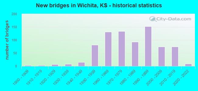
- New bridges - historical statistics
- 41900-1909
- 41910-1919
- 71920-1929
- 81930-1939
- 151940-1949
- 811950-1959
- 1311960-1969
- 1341970-1979
- 931980-1989
- 1521990-1999
- 742000-2009
- 742010-2019
- 92020-2022
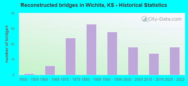
- Reconstructed bridges - Historical Statistics
- 11950-1959
- 61960-1969
- 241970-1979
- 331980-1989
- 281990-1999
- 182000-2009
- 142010-2019
- 182020-2022
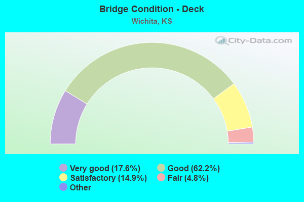
- Bridge Condition - Deck
- 17.6%Very good
- 62.2%Good
- 14.9%Satisfactory
- 4.8%Fair
- 0.5%Poor
- 0.2%Serious
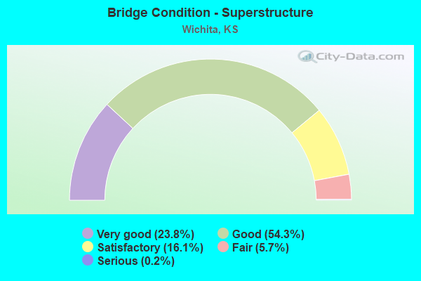
- Bridge Condition - Superstructure
- 23.8%Very good
- 54.3%Good
- 16.1%Satisfactory
- 5.7%Fair
- 0.2%Serious
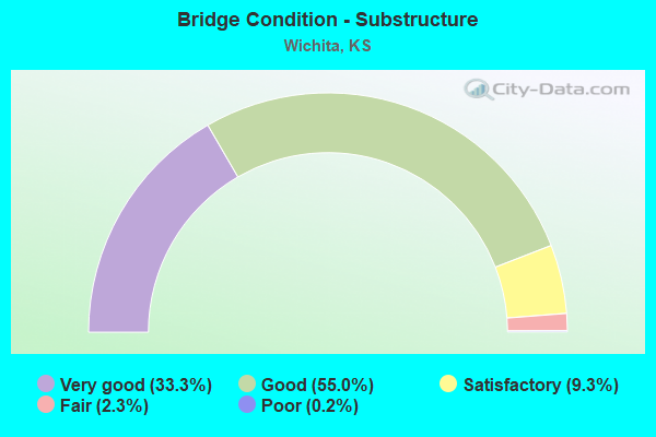
- Bridge Condition - Substructure
- 33.3%Very good
- 55.0%Good
- 9.3%Satisfactory
- 2.3%Fair
- 0.2%Poor
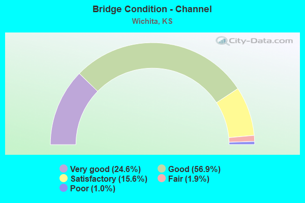
- Bridge Condition - Channel
- 24.6%Very good
- 56.9%Good
- 15.6%Satisfactory
- 1.9%Fair
- 1.0%Poor
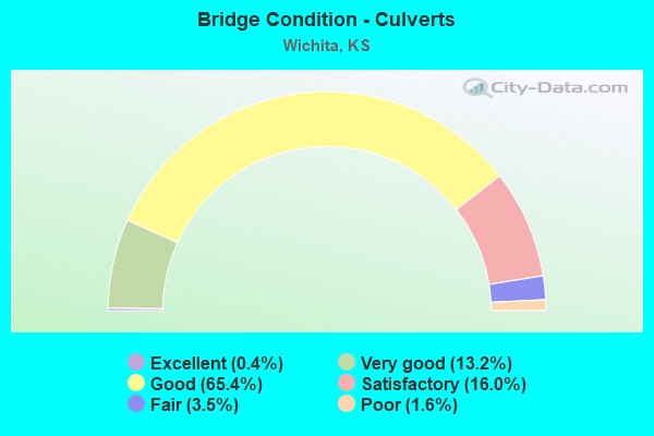
- Bridge Condition - Culverts
- 0.4%Excellent
- 13.2%Very good
- 65.4%Good
- 16.0%Satisfactory
- 3.5%Fair
- 1.6%Poor
Find on map >> Show street view
Structure Number: 999913500873081, Location: 0.25 MI N-MT VERNON AVE (Lat: 37.660833, Lng: -97.312222), Route carried "under" structure: Interstate 135, Year Built: 1976, Structure Length: 0. m, Average Daily Traffic: 32,565 (year 2020), Truck Traffic: 8%, Features Intersected: I135 E&W LANES & CNL, Facility Carried by Structure: PEDESTRIAN OV-PASS
Minimum Vertical Clearance: 5.20m (17.06ft), Kilometerpoint: 8.362, Lanes under structure: 8, Material/Design: Concrete continuous, Design/Construction: Slab, Length of Maximum Span: 32.0m (105.0ft)
Find on map >> Show street view
Structure Number: 999913500873091, Location: 0.71 MI N-MT.VERNON AVE (Lat: 37.667500, Lng: -97.312500), Route carried "under" structure: Interstate 135, Year Built: 1976, Structure Length: 0. m, Average Daily Traffic: 34,878 (year 2020), Truck Traffic: 8%, Features Intersected: I135 E&W LANES & CNL, Facility Carried by Structure: PEDESTRIAN OV-PASS
Minimum Vertical Clearance: 5.22m (17.13ft), Kilometerpoint: 9.096, Lanes under structure: 8, Material/Design: Concrete continuous, Design/Construction: Slab, Length of Maximum Span: 32.0m (105.0ft)
Find on map >> Show street view
Structure Number: 999913500873101, Location: JCT. LINCOLN AVE & I35 (Lat: 37.671667, Lng: -97.312500), Route carried "under" structure: Interstate 135, Year Built: 1976, Structure Length: 0. m, Average Daily Traffic: 36,057 (year 2020), Truck Traffic: 8%, Features Intersected: I135 HWY EL&WL -CANAL, Facility Carried by Structure: LINCOLN ST.
Minimum Vertical Clearance: 4.93m (16.17ft), Kilometerpoint: 9.543, Lanes on structure: 8, Lanes under structure: 8, Material/Design: Concrete continuous, Design/Construction: Box Beam or Girders - Multiple, Length of Maximum Span: 29.9m (98.1ft)
Find on map >> Show street view
Structure Number: 999923500870321, Location: JCT I235/I135 (Lat: 37.759722, Lng: -97.322500), Route carried "under" structure: Interstate 135, Year Built: 1964, Structure Length: 0. m, Average Daily Traffic: 20,863 (year 2020), Truck Traffic: 13%, Features Intersected: I135 HWY SB, Facility Carried by Structure: I235 HWY, NB
Minimum Vertical Clearance: 4.64m (15.22ft), Kilometerpoint: 19.296, Lanes on structure: 1, Lanes under structure: 2, Material/Design: Concrete continuous, Design/Construction: Box Beam or Girders - Multiple, Length of Maximum Span: 20.7m (67.9ft)
Find on map >> Show street view
Structure Number: 999923500870341, Location: 0.06 MI N I235, SB (Lat: 37.761389, Lng: -97.323056), Route carried "under" structure: Interstate 135, Year Built: 1964, Structure Length: 0. m, Average Daily Traffic: 20,863 (year 2020), Truck Traffic: 13%, Features Intersected: I-135 HWY SB, Facility Carried by Structure: I235 HWY, SB
Minimum Vertical Clearance: 4.62m (15.16ft), Kilometerpoint: 19.515, Lanes on structure: 1, Lanes under structure: 2, Material/Design: Concrete continuous, Design/Construction: Slab, Length of Maximum Span: 15.5m (50.9ft)
Find on map >> Show street view
Structure Number: 999923500870621, Location: 0.34 MI W I135, SB (Lat: 37.616111, Lng: -97.330833), Route carried "under" structure: Interstate 235, Year Built: 1965, Structure Length: 0. m, Average Daily Traffic: 18,414 (year 2020), Truck Traffic: 8%, Features Intersected: I235 HWY, NB
Minimum Vertical Clearance: 5.11m (16.77ft), Kilometerpoint: 0.562, Lanes on structure: 1, Lanes under structure: 2, Material/Design: Steel continuous, Design/Construction: Stringer/Multi-beam, Length of Maximum Span: 25.3m (83.0ft)
Find on map >> Show street view
Structure Number: 999923500870811, Location: JCT K42/I235 SB (Lat: 37.646389, Lng: -97.398889), Route carried "under" structure: State highway 42, Year Built: 1961, Structure Length: 0. m, Average Daily Traffic: 8,685 (year 2020), Truck Traffic: 5%, Features Intersected: K-42 HWY, Facility Carried by Structure: I235 HWY, SB
Minimum Vertical Clearance: 7.48m (24.54ft), Kilometerpoint: 31.429, Lanes under structure: 4, Material/Design: Steel continuous, Design/Construction: Stringer/Multi-beam, Length of Maximum Span: 20.4m (66.9ft)
Find on map >> Show street view
Structure Number: 999923500870821, Location: JCT K42/I235 NB (Lat: 37.646667, Lng: -97.398611), Route carried "under" structure: State highway 42, Year Built: 1961, Structure Length: 0. m, Average Daily Traffic: 8,685 (year 2020), Truck Traffic: 5%, Features Intersected: K-42 HWY, Facility Carried by Structure: I235 HWY, NB
Minimum Vertical Clearance: 7.56m (24.80ft), Kilometerpoint: 31.456, Lanes under structure: 4, Material/Design: Steel continuous, Design/Construction: Stringer/Multi-beam, Length of Maximum Span: 20.3m (66.6ft)
Find on map >> Show street view
Structure Number: 999923500870871, Location: JCT US54/I235 (Lat: 37.673056, Lng: -97.401389), Route carried "under" structure: US 54, Year Built: 1961, Structure Length: 0. m, Average Daily Traffic: 38,966 (year 2020), Truck Traffic: 3%, Features Intersected: US54 HWY, Facility Carried by Structure: I235 HWY, SB
Minimum Vertical Clearance: 4.78m (15.68ft), Kilometerpoint: 36.167, Lanes on structure: 3, Lanes under structure: 4, Material/Design: Concrete continuous, Design/Construction: Slab, Length of Maximum Span: 19.2m (63.0ft)
Find on map >> Show street view
Structure Number: 999923500870881, Location: JCT US54/I235, NB (Lat: 37.673056, Lng: -97.401111), Route carried "under" structure: US 54, Year Built: 1961, Structure Length: 0. m, Average Daily Traffic: 38,731 (year 2020), Truck Traffic: 5%, Features Intersected: US54 HWY, Facility Carried by Structure: I235 HWY, NB
Minimum Vertical Clearance: 5.18m (16.99ft), Kilometerpoint: 36.191, Lanes on structure: 7, Lanes under structure: 7, Material/Design: Concrete continuous, Design/Construction: Slab, Length of Maximum Span: 19.2m (63.0ft)
Find on map >> Show street view
Structure Number: 999923500873211, Location: 0.89 MI E WEST ST (Lat: 37.754722, Lng: -97.373889), Route carried "under" structure: Ramp State highway 76, Year Built: 1980, Structure Length: 0. m, Average Daily Traffic: 15,511 (year 2020), Truck Traffic: 14%, Features Intersected: I235 HWY, Facility Carried by Structure: 96 HWY EB EXIT RP
Minimum Vertical Clearance: 5.05m (16.57ft), Kilometerpoint: 21.679, Lanes on structure: 1, Lanes under structure: 4, Material/Design: Steel continuous, Design/Construction: Stringer/Multi-beam, Length of Maximum Span: 31.4m (103.0ft)
Find on map >> Show street view
Structure Number: 999923500873251, Location: 3.16 MI NE ZOO BLVD (Lat: 37.756944, Lng: -97.370556), Route carried "under" structure: Interstate 235, Year Built: 1980, Structure Length: 0. m, Average Daily Traffic: 15,511 (year 2020), Truck Traffic: 13%, Features Intersected: I235 HWY, Facility Carried by Structure: MERIDIAN, NB
Minimum Vertical Clearance: 5.02m (16.47ft), Kilometerpoint: 22.095, Lanes on structure: 2, Lanes under structure: 4, Material/Design: Prestressed concrete continuous, Design/Construction: Stringer/Multi-beam, Length of Maximum Span: 26.8m (87.9ft)
Find on map >> Show street view
Structure Number: 999923500873261, Location: 3.15 MI NE ZOO B (Lat: 37.756944, Lng: -97.370833), Route carried "under" structure: Interstate 235, Year Built: 1980, Structure Length: 0. m, Average Daily Traffic: 15,511 (year 2020), Truck Traffic: 13%, Features Intersected: I235 HWY, Facility Carried by Structure: MERIDIAN, SB
Minimum Vertical Clearance: 5.03m (16.50ft), Kilometerpoint: 22.079, Lanes on structure: 2, Lanes under structure: 4, Material/Design: Prestressed concrete continuous, Design/Construction: Stringer/Multi-beam, Length of Maximum Span: 26.8m (87.9ft)
Find on map >> Show street view
Structure Number: 999923500877991, Location: RAMP NB235-WB13 (Lat: 37.708333, Lng: -97.408889), Route carried "under" structure: County highway 6380, Year Built: 2014, Structure Length: 0. m, Average Daily Traffic: 19,140 (year 2020), Truck Traffic: 11%, Features Intersected: RMP LEVRD WICHFLDWY I235, Facility Carried by Structure: RAMP NB235-WB13
Minimum Vertical Clearance: 6.75m (22.15ft), Kilometerpoint: 15.240, Lanes on structure: 2, Lanes under structure: 2, Material/Design: Steel continuous, Design/Construction: Stringer/Multi-beam, Length of Maximum Span: 68.6m (225.1ft)
Find on map >> Show street view
Structure Number: 999923500877991, Location: RAMP NB235-WB13 (Lat: 37.708333, Lng: -97.408889), Route carried "under" structure: County highway 6380, Year Built: 2014, Structure Length: 0. m, Average Daily Traffic: 19,140 (year 2020), Truck Traffic: 11%, Features Intersected: RMP LEVRD WICHFLDWY I235, Facility Carried by Structure: RAMP NB235-WB13
Minimum Vertical Clearance: 5.15m (16.90ft), Kilometerpoint: 15.240, Lanes on structure: 2, Lanes under structure: 4, Material/Design: Steel continuous, Design/Construction: Stringer/Multi-beam, Length of Maximum Span: 68.6m (225.1ft)
Find on map >> Show street view
Structure Number: 999923500877991, Location: RAMP NB235-WB13 (Lat: 37.708333, Lng: -97.408889), Route carried "under" structure: County highway 6380, Year Built: 2014, Structure Length: 0. m, Average Daily Traffic: 19,140 (year 2020), Truck Traffic: 11%, Features Intersected: RMP LEVRD WICHFLDWY I235, Facility Carried by Structure: RAMP NB235-WB13
Minimum Vertical Clearance: 6.82m (22.38ft), Kilometerpoint: 15.240, Lanes on structure: 2, Lanes under structure: 1, Material/Design: Steel continuous, Design/Construction: Stringer/Multi-beam, Length of Maximum Span: 68.6m (225.1ft)
Find on map >> Show street view
Structure Number: 999923500878201, Location: NB I-235 TO WB US 54/400 (Lat: 37.672778, Lng: -97.401389), Route carried "under" structure: US 54, Year Built: 2019, Structure Length: 0. m, Average Daily Traffic: 38,966 (year 2020), Truck Traffic: 5%, Features Intersected: I235, WICHITA VLY FLDWY
Minimum Vertical Clearance: 5.81m (19.06ft), Kilometerpoint: 36.144, Lanes on structure: 1, Lanes under structure: 5, Material/Design: Steel continuous, Design/Construction: Stringer/Multi-beam, Length of Maximum Span: 64.3m (211.0ft)
Find on map >> Show street view
Structure Number: 999923500878221, Location: SB I-235 TO EB US-54/400 (Lat: 37.673056, Lng: -97.401389), Route carried "under" structure: ServiceState highway 56, Year Built: 2018, Structure Length: 0. m, Average Daily Traffic: 38,731 (year 2020), Truck Traffic: 6%, Features Intersected: I-235 HWY, Facility Carried by Structure: SB I235 TO EB US54
Minimum Vertical Clearance: 5.51m (18.08ft), Kilometerpoint: 36.193, Lanes under structure: 6, Material/Design: Steel continuous, Design/Construction: Stringer/Multi-beam, Length of Maximum Span: 65.4m (214.6ft)
Find on map >> Show street view
Structure Number: 999923500878371, Location: JCT 25TH ST/I235 (Lat: 37.731389, Lng: -97.380278), Route carried "under" structure: Interstate 235, Year Built: 2017, Structure Length: 0. m, Average Daily Traffic: 15,511 (year 2020), Truck Traffic: 13%, Features Intersected: I235 NB & SB, Facility Carried by Structure: 25TH STREET
Minimum Vertical Clearance: 5.30m (17.39ft), Kilometerpoint: 18.902, Lanes on structure: 4, Lanes under structure: 4, Material/Design: Prestressed concrete continuous, Design/Construction: Stringer/Multi-beam, Length of Maximum Span: 33.5m (109.9ft)
Find on map >> Show street view
Structure Number: 999925400870331, Location: JCT I235/I135, EB (Lat: 37.761111, Lng: -97.320556), Route carried "under" structure: Interstate 135, Year Built: 1964, Structure Length: 0. m, Average Daily Traffic: 20,863 (year 2020), Truck Traffic: 13%, Features Intersected: I135 HWY NB, Facility Carried by Structure: K 254 HWY EB
Minimum Vertical Clearance: 4.63m (15.19ft), Kilometerpoint: 19.721, Lanes on structure: 1, Lanes under structure: 2, Material/Design: Concrete continuous, Design/Construction: Slab, Length of Maximum Span: 17.7m (58.1ft)
Find on map >> Show street view
Structure Number: 999925400870351, Location: 0.09 MI N I235, WB (Lat: 37.762500, Lng: -97.320833), Route carried "under" structure: State highway 96, Year Built: 1964, Structure Length: 0. m, Average Daily Traffic: 20,863 (year 2020), Truck Traffic: 13%, Features Intersected: 135NB,RAMP A,RAMP E E, Facility Carried by Structure: K 254 HWY WB
Minimum Vertical Clearance: 4.84m (15.88ft), Kilometerpoint: 39.725, Lanes on structure: 2, Lanes under structure: 2, Material/Design: Concrete continuous, Design/Construction: Slab, Length of Maximum Span: 17.1m (56.1ft)
Find on map >> Show street view
Structure Number: 999925400870351, Location: 0.09 MI N I235, WB (Lat: 37.762500, Lng: -97.320833), Route carried "under" structure: State highway 96, Year Built: 1964, Structure Length: 0. m, Average Daily Traffic: 20,863 (year 2020), Truck Traffic: 13%, Features Intersected: 135NB,RAMP A,RAMP E E, Facility Carried by Structure: K 254 HWY WB
Minimum Vertical Clearance: 5.28m (17.32ft), Kilometerpoint: 39.725, Lanes on structure: 2, Lanes under structure: 1, Material/Design: Concrete continuous, Design/Construction: Slab, Length of Maximum Span: 17.1m (56.1ft)
Find on map >> Show street view
Structure Number: 999925400870351, Location: 0.09 MI N I235, WB (Lat: 37.762500, Lng: -97.320833), Route carried "under" structure: State highway 96, Year Built: 1964, Structure Length: 0. m, Average Daily Traffic: 20,863 (year 2020), Truck Traffic: 13%, Features Intersected: 135NB,RAMP A,RAMP E E, Facility Carried by Structure: K 254 HWY WB
Minimum Vertical Clearance: 4.61m (15.12ft), Kilometerpoint: 39.725, Lanes on structure: 2, Lanes under structure: 1, Material/Design: Concrete continuous, Design/Construction: Slab, Length of Maximum Span: 17.1m (56.1ft)
Find on map >> Show street view
Structure Number: 999925400873301, Location: 0.65 MI N 37TH STREET (Lat: 37.762778, Lng: -97.320833), Route carried "under" structure: State highway 96, Year Built: 1987, Structure Length: 0. m, Average Daily Traffic: 20,863 (year 2020), Truck Traffic: 13%, Features Intersected: K254 & I135, Facility Carried by Structure: I135 SB-254 EB RP
Minimum Vertical Clearance: 4.96m (16.27ft), Kilometerpoint: 39.323, Lanes on structure: 2, Lanes under structure: 2, Material/Design: Steel continuous, Design/Construction: Stringer/Multi-beam, Length of Maximum Span: 36.0m (118.1ft)
Find on map >> Show street view
Structure Number: 999925400873301, Location: 0.65 MI N 37TH STREET (Lat: 37.762778, Lng: -97.320833), Route carried "under" structure: State highway 96, Year Built: 1987, Structure Length: 0. m, Average Daily Traffic: 20,863 (year 2020), Truck Traffic: 13%, Features Intersected: K254 & I135, Facility Carried by Structure: I135 SB-254 EB RP
Minimum Vertical Clearance: 7.62m (25.00ft), Kilometerpoint: 39.323, Lanes on structure: 1, Lanes under structure: 1, Material/Design: Steel continuous, Design/Construction: Stringer/Multi-beam, Length of Maximum Span: 36.0m (118.1ft)