Bridge Statistics for Wichita, Kansas (KS)
Condition, Traffic, Stress, Structural Evaluation, Project Costs
- National Bridge Inventory (NBI) Statistics
- 786Number of bridges
- 16,591ft / 5,057mTotal length
- $13,844,000Total costs
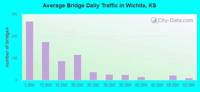
- 9,470,559Total average daily traffic
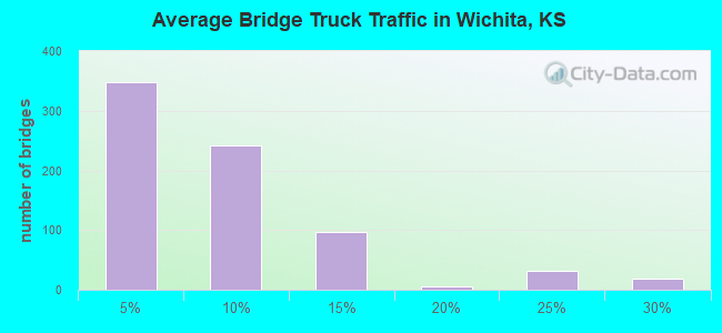
- 625,083Total average daily truck traffic
- National Bridge Inventory (NBI) Registered Bridges for Wichita
- No street view available for this location
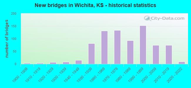
- New bridges - historical statistics
- 41900-1909
- 41910-1919
- 71920-1929
- 81930-1939
- 151940-1949
- 811950-1959
- 1311960-1969
- 1341970-1979
- 931980-1989
- 1521990-1999
- 742000-2009
- 742010-2019
- 92020-2022
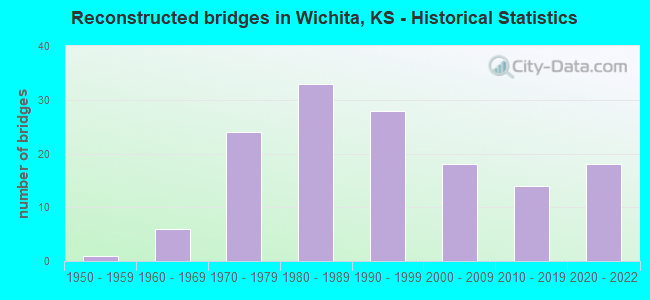
- Reconstructed bridges - Historical Statistics
- 11950-1959
- 61960-1969
- 241970-1979
- 331980-1989
- 281990-1999
- 182000-2009
- 142010-2019
- 182020-2022
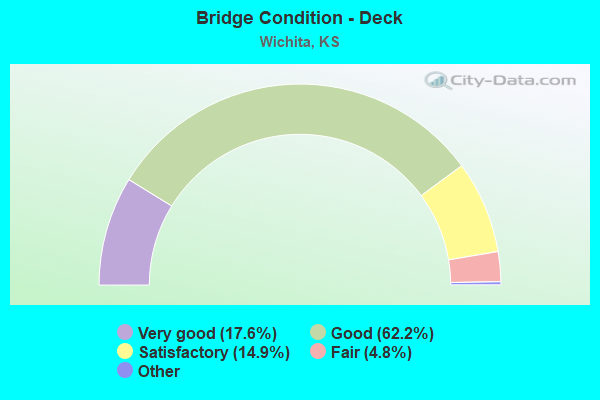
- Bridge Condition - Deck
- 17.6%Very good
- 62.2%Good
- 14.9%Satisfactory
- 4.8%Fair
- 0.5%Poor
- 0.2%Serious
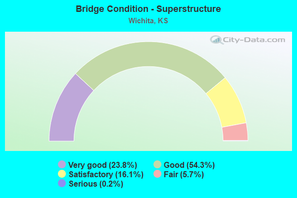
- Bridge Condition - Superstructure
- 23.8%Very good
- 54.3%Good
- 16.1%Satisfactory
- 5.7%Fair
- 0.2%Serious
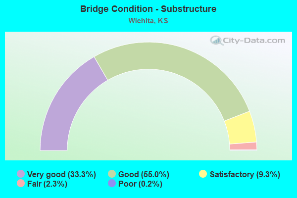
- Bridge Condition - Substructure
- 33.3%Very good
- 55.0%Good
- 9.3%Satisfactory
- 2.3%Fair
- 0.2%Poor
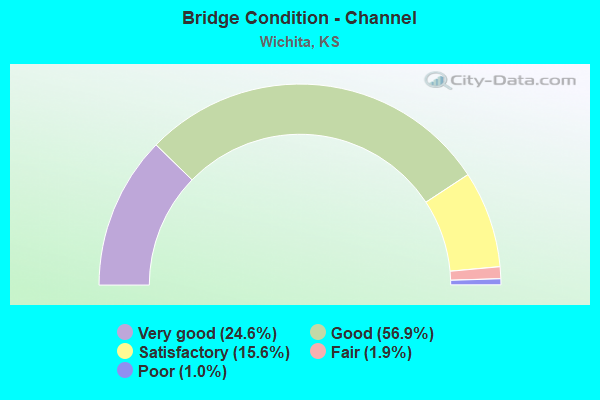
- Bridge Condition - Channel
- 24.6%Very good
- 56.9%Good
- 15.6%Satisfactory
- 1.9%Fair
- 1.0%Poor
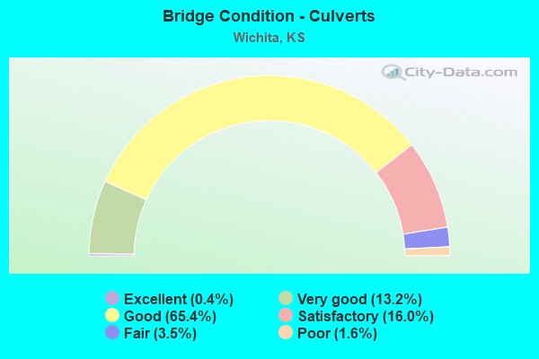
- Bridge Condition - Culverts
- 0.4%Excellent
- 13.2%Very good
- 65.4%Good
- 16.0%Satisfactory
- 3.5%Fair
- 1.6%Poor
Find on map >> Show street view
Structure Number: 530400870CCWR8, Location: 17TH AT AMARADO (Lat: 37.715636, Lng: -97.453814), Route carried "on" structure: City street , Year Built: 1981, Status: Open, Structure Length: 1.07m (3.51ft), Average Daily Traffic: 525 (year 2006), Truck Traffic: 1%, Average Future Daily Traffic: 790 (year 2039), Design Load: H 20, Features Intersected: WESTLINK TRIB COWSKIN CR, Facility Carried by Structure: 17TH STREET NORTH
Minimum Vertical Clearance: 30.47m (99.97ft), Kilometerpoint: 0.000, Lanes on structure: 2, Owner: City or Municipal Highway Agency, Approaching Roadway Width: 10.9m (35.8ft), Material/Design: Concrete, Design/Construction: Culvert, Number Of Spans In Main Unit: 4, Length of Maximum Span: 2.4m (7.9ft), Curb or Sidewalk Widths: Left: 1.2m (3.9ft), Right: 1.2m (3.9ft)
Condition: Channel: Good, Culverts: Satisfactory, Operating Rating: 54.4 metric tons, Method Used To Determine Operating Rating: Load Factor (LF), Inventory Rating: 32.7 metric tons, Method Used To Determine Inventory Rating: Load Factor (LF), Structural Evaluation: Equal to present minimum criteria, Waterway Adequacy: Better than present minimum criteria, Approach Roadway Alignment: Equal to present desirable criteria, Designated Inspection Frequency: Every 24 months, Inspection Date: August 2021, Wearing Surface/Protective System: Wearing Surface: Bituminous
Find on map >> Show street view
Structure Number: 530400870CSCR1, Location: 13TH W. OF 119TH ST. W (Lat: 37.708333, Lng: -97.485000), Route carried "on" structure: City street , Year Built: 2005, Status: Open, Structure Length: 8.11m (26.61ft), Average Daily Traffic: 4,000 (year 2006), Truck Traffic: 2%, Average Future Daily Traffic: 6,000 (year 2039), Design Load: HS 20, Features Intersected: COWSKIN CREEK, Facility Carried by Structure: 13TH ST. N
Minimum Vertical Clearance: 30.47m (99.97ft), Kilometerpoint: 0.000, Lanes on structure: 4, Owner: City or Municipal Highway Agency, Approaching Roadway Width: 14.6m (47.9ft), Skew: 1 degrees, Material/Design: Concrete continuous, Design/Construction: Slab, Number Of Spans In Main Unit: 5, Length of Maximum Span: 18.0m (59.1ft), Curb or Sidewalk Widths: Left: 1.8m (5.9ft), Right: 1.8m (5.9ft), Curb-To-Curb Width: 14.6m (47.9ft), Out-to-Out Width: 19.5m (64.0ft)
Condition: Deck: Good, Superstructure: Good, Substructure: Good, Channel: Good, Operating Rating: 84.2 metric tons, Method Used To Determine Operating Rating: Load Factor (LF), Inventory Rating: 50.4 metric tons, Method Used To Determine Inventory Rating: Load Factor (LF), Structural Evaluation: Better than present minimum criteria, Deck Geometry: High priority of replacement, Waterway Adequacy: Equal to present desirable criteria, Approach Roadway Alignment: Equal to present desirable criteria, Designated Inspection Frequency: Every 24 months, Inspection Date: September 2021, Deck Structure Type: Concrete Cast-file-Place, Wearing Surface/Protective System: Wearing Surface: Latex Concrete, Deck Protection: Epoxy Coated Reinforcing
Find on map >> Show street view
Structure Number: 530400870DTHD1, Location: UNIVERSITY AT TAFT (Lat: 37.677592, Lng: -97.429264), Route carried "on" structure: City street , Year Built: 1988, Status: Open, Structure Length: 0.86m (2.82ft), Average Daily Traffic: 2,435 (year 2006), Truck Traffic: 1%, Average Future Daily Traffic: 3,675 (year 2039), Design Load: HS 20, Features Intersected: HOOVER ST. DR. DUGAN TRI, Facility Carried by Structure: UNIVERSITY
Minimum Vertical Clearance: 30.47m (99.97ft), Kilometerpoint: 0.000, Lanes on structure: 2, Owner: City or Municipal Highway Agency, Approaching Roadway Width: 12.1m (39.7ft), Material/Design: Concrete, Design/Construction: Culvert, Number Of Spans In Main Unit: 3, Length of Maximum Span: 2.7m (8.9ft)
Condition: Channel: Good, Culverts: Good, Operating Rating: 55.3 metric tons, Method Used To Determine Operating Rating: Load Factor (LF), Inventory Rating: 33.6 metric tons, Method Used To Determine Inventory Rating: Load Factor (LF), Structural Evaluation: Better than present minimum criteria, Waterway Adequacy: Equal to present desirable criteria, Approach Roadway Alignment: Equal to present desirable criteria, Designated Inspection Frequency: Every 24 months, Inspection Date: September 2021, Wearing Surface/Protective System: Wearing Surface: Bituminous
Find on map >> Show street view
Structure Number: 530400870EBGC1, Location: 19TH E OF WEBB (Lat: 37.718975, Lng: -97.223714), Route carried "on" structure: City street , Year Built: 1988, Status: Open, Structure Length: 1.45m (4.76ft), Average Daily Traffic: 400 (year 2006), Truck Traffic: 2%, Average Future Daily Traffic: 600 (year 2039), Features Intersected: TRIB TO BEECH LAKE, Facility Carried by Structure: 19TH STREET N
Minimum Vertical Clearance: 30.47m (99.97ft), Kilometerpoint: 0.000, Lanes on structure: 2, Owner: City or Municipal Highway Agency, Approaching Roadway Width: 10.3m (33.8ft), Material/Design: Concrete, Design/Construction: Culvert, Number Of Spans In Main Unit: 4, Length of Maximum Span: 3.5m (11.5ft)
Condition: Channel: Good, Culverts: Good, Operating Rating: 28.1 metric tons, Method Used To Determine Operating Rating: Load Factor (LF), Inventory Rating: 18.1 metric tons, Method Used To Determine Inventory Rating: Load Factor (LF), Structural Evaluation: Somewhat better than minimum adequacy, Waterway Adequacy: Equal to present minimum criteria, Approach Roadway Alignment: Equal to present desirable criteria, Designated Inspection Frequency: Every 24 months, Inspection Date: September 2021, Wearing Surface/Protective System: Wearing Surface: Bituminous
Find on map >> Show street view
Structure Number: 530400870EBGC2, Location: 13TH E OF WEBB (Lat: 37.708333, Lng: -97.225000), Route carried "on" structure: City street , Year Built: 2000, Status: Open, Structure Length: 0.82m (2.69ft), Average Daily Traffic: 12,000 (year 2006), Truck Traffic: 2%, Average Future Daily Traffic: 16,000 (year 2039), Design Load: HS 20, Features Intersected: BEECH LAKE, Facility Carried by Structure: 13TH STREET N
Minimum Vertical Clearance: 30.47m (99.97ft), Kilometerpoint: 0.000, Lanes on structure: 4, Owner: City or Municipal Highway Agency, Approaching Roadway Width: 14.9m (48.9ft), Material/Design: Concrete, Design/Construction: Slab, Number Of Spans In Main Unit: 1, Length of Maximum Span: 8.2m (26.9ft), Curb or Sidewalk Widths: Left: 2.0m (6.6ft), Right: 2.0m (6.6ft), Curb-To-Curb Width: 18.3m (60.0ft), Out-to-Out Width: 23.2m (76.1ft)
Condition: Deck: Good, Superstructure: Good, Substructure: Good, Channel: Good, Operating Rating: 49.0 metric tons, Method Used To Determine Operating Rating: Load Factor (LF), Inventory Rating: 29.9 metric tons, Method Used To Determine Inventory Rating: Load Factor (LF), Structural Evaluation: Better than present minimum criteria, Deck Geometry: Somewhat better than minimum adequacy, Waterway Adequacy: Equal to present minimum criteria, Approach Roadway Alignment: Better than present minimum criteria, Designated Inspection Frequency: Every 24 months, Inspection Date: September 2021, Wearing Surface/Protective System: Wearing Surface: Monolithic Concrete
Find on map >> Show street view
Structure Number: 530400870EFCC1, Location: JASMINE AND JASMINE CT (Lat: 37.757222, Lng: -97.246944), Route carried "on" structure: City street , Year Built: 1995, Status: Open, Structure Length: 0.66m (2.17ft), Average Daily Traffic: 200 (year 2006), Truck Traffic: 2%, Average Future Daily Traffic: 300 (year 2039), Design Load: HS 20, Features Intersected: TRIB E FORK CHISH CR, Facility Carried by Structure: JASMINE ST
Minimum Vertical Clearance: 30.47m (99.97ft), Kilometerpoint: 0.000, Lanes on structure: 2, Owner: City or Municipal Highway Agency, Approaching Roadway Width: 10.2m (33.5ft), Skew: 3 degrees, Material/Design: Concrete, Design/Construction: Culvert, Number Of Spans In Main Unit: 2, Length of Maximum Span: 3.1m (10.2ft)
Condition: Channel: Very good, Culverts: Good, Operating Rating: 30.8 metric tons, Method Used To Determine Operating Rating: Load Factor (LF), Inventory Rating: 19.1 metric tons, Method Used To Determine Inventory Rating: Load Factor (LF), Structural Evaluation: Somewhat better than minimum adequacy, Waterway Adequacy: Better than present minimum criteria, Approach Roadway Alignment: Equal to present desirable criteria, Designated Inspection Frequency: Every 24 months, Inspection Date: September 2021, Wearing Surface/Protective System: Wearing Surface: Bituminous
Find on map >> Show street view
Structure Number: 530400870GC102, Location: EASTERN AT ORME (Lat: 37.678319, Lng: -97.236572), Route carried "on" structure: City street , Year Built: 1999, Status: Open, Structure Length: 3.90m (12.80ft), Average Daily Traffic: 300 (year 2006), Truck Traffic: 2%, Average Future Daily Traffic: 400 (year 2039), Design Load: HS 20, Features Intersected: GYPSUM CREEK, Facility Carried by Structure: EASTERN
Minimum Vertical Clearance: 30.47m (99.97ft), Kilometerpoint: 0.000, Lanes on structure: 2, Owner: City or Municipal Highway Agency, Approaching Roadway Width: 9.8m (32.2ft), Skew: 3 degrees, Material/Design: Concrete continuous, Design/Construction: Slab, Number Of Spans In Main Unit: 3, Length of Maximum Span: 15.9m (52.2ft), Curb or Sidewalk Widths: Left: 1.8m (5.9ft), Right: 1.8m (5.9ft), Curb-To-Curb Width: 10.0m (32.8ft), Out-to-Out Width: 14.6m (47.9ft)
Condition: Deck: Good, Superstructure: Good, Substructure: Good, Channel: Good, Operating Rating: 68.1 metric tons, Method Used To Determine Operating Rating: Load Factor (LF), Inventory Rating: 40.8 metric tons, Method Used To Determine Inventory Rating: Load Factor (LF), Structural Evaluation: Better than present minimum criteria, Deck Geometry: Better than present minimum criteria, Waterway Adequacy: Better than present minimum criteria, Approach Roadway Alignment: Equal to present desirable criteria, Designated Inspection Frequency: Every 24 months, Inspection Date: September 2021, Deck Structure Type: Concrete Cast-file-Place, Wearing Surface/Protective System: Wearing Surface: Latex Concrete, Deck Protection: Epoxy Coated Reinforcing
Find on map >> Show street view
Structure Number: 530400870GCA91, Location: ORME AND ARMOUR (Lat: 37.677753, Lng: -97.249689), Route carried "on" structure: City street , Year Built: 1974, Status: Open, Structure Length: 0.70m (2.30ft), Average Daily Traffic: 150 (year 2006), Truck Traffic: 2%, Average Future Daily Traffic: 200 (year 2039), Design Load: HS 20, Features Intersected: TRIB TO GYPSUM CREEK, Facility Carried by Structure: ORME
Minimum Vertical Clearance: 30.47m (99.97ft), Kilometerpoint: 0.000, Lanes on structure: 2, Owner: City or Municipal Highway Agency, Approaching Roadway Width: 9.1m (29.9ft), Material/Design: Concrete, Design/Construction: Culvert, Number Of Spans In Main Unit: 3, Length of Maximum Span: 2.1m (6.9ft), Curb or Sidewalk Widths: Left: 2.4m (7.9ft), Right: 2.4m (7.9ft)
Condition: Channel: Very good, Culverts: Good, Operating Rating: 39.0 metric tons, Method Used To Determine Operating Rating: Load Factor (LF), Inventory Rating: 22.7 metric tons, Method Used To Determine Inventory Rating: Load Factor (LF), Structural Evaluation: Equal to present minimum criteria, Waterway Adequacy: Equal to present desirable criteria, Approach Roadway Alignment: Equal to present desirable criteria, Designated Inspection Frequency: Every 24 months, Inspection Date: September 2021, Wearing Surface/Protective System: Wearing Surface: Monolithic Concrete
Find on map >> Show street view
Structure Number: 530400870GCA92, Location: ARMOUR AT KELLOGG (Lat: 37.680808, Lng: -97.250500), Route carried "on" structure: City street , Year Built: 2006, Status: Open, Structure Length: 0.69m (2.26ft), Average Daily Traffic: 6,945 (year 2009), Truck Traffic: 4%, Average Future Daily Traffic: 12,947 (year 2039), Design Load: H 20, Features Intersected: ARMOUR BRANCH GYPSUM CR, Facility Carried by Structure: ARMOUR ROAD
Minimum Vertical Clearance: 30.47m (99.97ft), Kilometerpoint: 0.000, Lanes on structure: 3, Owner: City or Municipal Highway Agency, Approaching Roadway Width: 11.2m (36.7ft), Material/Design: Concrete, Design/Construction: Culvert, Number Of Spans In Main Unit: 3, Length of Maximum Span: 2.1m (6.9ft)
Condition: Channel: Very good, Culverts: Good, Operating Rating: 49.9 metric tons, Method Used To Determine Operating Rating: Load Factor (LF), Inventory Rating: 29.9 metric tons, Method Used To Determine Inventory Rating: Load Factor (LF), Structural Evaluation: Better than present minimum criteria, Waterway Adequacy: Equal to present desirable criteria, Approach Roadway Alignment: Equal to present desirable criteria, Designated Inspection Frequency: Every 24 months, Inspection Date: September 2021, Wearing Surface/Protective System: Wearing Surface: Bituminous
Find on map >> Show street view
Structure Number: 530400870GCA93, Location: WHITTIER AT ARMOUR (Lat: 37.685611, Lng: -97.252528), Route carried "on" structure: City street , Year Built: 1974, Status: Open, Structure Length: 0.69m (2.26ft), Average Daily Traffic: 300 (year 2006), Truck Traffic: 2%, Average Future Daily Traffic: 400 (year 2039), Design Load: H 20, Features Intersected: ARMOUR BRANCH GYPSUM CR, Facility Carried by Structure: WHITTIER
Minimum Vertical Clearance: 30.47m (99.97ft), Kilometerpoint: 0.000, Lanes on structure: 2, Owner: City or Municipal Highway Agency, Approaching Roadway Width: 12.1m (39.7ft), Material/Design: Concrete, Design/Construction: Culvert, Number Of Spans In Main Unit: 3, Length of Maximum Span: 2.1m (6.9ft), Curb or Sidewalk Widths: Left: 2.4m (7.9ft), Right: 0.0m
Condition: Channel: Good, Culverts: Good, Operating Rating: 52.6 metric tons, Method Used To Determine Operating Rating: Load Factor (LF), Inventory Rating: 31.8 metric tons, Method Used To Determine Inventory Rating: Load Factor (LF), Structural Evaluation: Better than present minimum criteria, Waterway Adequacy: Better than present minimum criteria, Approach Roadway Alignment: Better than present minimum criteria, Designated Inspection Frequency: Every 24 months, Inspection Date: September 2021, Wearing Surface/Protective System: Wearing Surface: Bituminous
Find on map >> Show street view
Structure Number: 530400870GCA94, Location: WILLOWBROOK AT ARMOUR (Lat: 37.684678, Lng: -97.252050), Route carried "on" structure: City street , Year Built: 1975, Status: Open, Structure Length: 0.69m (2.26ft), Average Daily Traffic: 3,200 (year 2006), Truck Traffic: 4%, Average Future Daily Traffic: 4,500 (year 2039), Design Load: H 20, Features Intersected: ARMOUR BRANCH GYPSUM CR, Facility Carried by Structure: SWNB drive
Minimum Vertical Clearance: 30.47m (99.97ft), Kilometerpoint: 0.000, Lanes on structure: 2, Owner: City or Municipal Highway Agency, Approaching Roadway Width: 10.3m (33.8ft), Skew: 20 degrees, Material/Design: Concrete, Design/Construction: Culvert, Number Of Spans In Main Unit: 3, Length of Maximum Span: 2.1m (6.9ft), Curb or Sidewalk Widths: Left: 1.5m (4.9ft), Right: 1.5m (4.9ft), Curb-To-Curb Width: 9.1m (29.9ft), Out-to-Out Width: 14.3m (46.9ft)
Condition: Channel: Good, Culverts: Satisfactory, Operating Rating: 51.1 metric tons, Method Used To Determine Operating Rating: Load Factor (LF), Inventory Rating: 30.6 metric tons, Method Used To Determine Inventory Rating: Load Factor (LF), Structural Evaluation: Equal to present minimum criteria, Deck Geometry: Meets minimum limits, Waterway Adequacy: Better than present minimum criteria, Approach Roadway Alignment: Equal to present desirable criteria, Designated Inspection Frequency: Every 24 months, Inspection Date: September 2021, Wearing Surface/Protective System: Wearing Surface: Integral Concrete
Find on map >> Show street view
Structure Number: 530400870GCA945, Location: TARGET ENTRANCE AT ARMOUR (Lat: 37.682778, Lng: -97.250556), Route carried "on" structure: City street , Year Built: 1974, Status: Open, Structure Length: 0.69m (2.26ft), Average Daily Traffic: 4,000 (year 2006), Truck Traffic: 2%, Average Future Daily Traffic: 6,000 (year 2039), Design Load: HS 20, Features Intersected: ARMOUR BRANCH GYPSUM CR, Facility Carried by Structure: TARGET ENTRANCE
Minimum Vertical Clearance: 30.47m (99.97ft), Kilometerpoint: 0.000, Lanes on structure: 2, Owner: City or Municipal Highway Agency, Approaching Roadway Width: 12.1m (39.7ft), Skew: 20 degrees, Material/Design: Concrete, Design/Construction: Culvert, Number Of Spans In Main Unit: 3, Length of Maximum Span: 2.1m (6.9ft), Curb or Sidewalk Widths: Left: 1.2m (3.9ft), Right: 1.5m (4.9ft), Curb-To-Curb Width: 12.2m (40.0ft), Out-to-Out Width: 17.1m (56.1ft)
Condition: Channel: Good, Culverts: Good, Operating Rating: 39.0 metric tons, Method Used To Determine Operating Rating: Load Factor (LF), Inventory Rating: 22.7 metric tons, Method Used To Determine Inventory Rating: Load Factor (LF), Structural Evaluation: Equal to present minimum criteria, Deck Geometry: Equal to present minimum criteria, Waterway Adequacy: Better than present minimum criteria, Approach Roadway Alignment: Equal to present desirable criteria, Designated Inspection Frequency: Every 24 months, Inspection Date: September 2021, Wearing Surface/Protective System: Wearing Surface: Bituminous
Find on map >> Show street view
Structure Number: 530400870GCCH1, Location: BLUESTEM AT WHITE OAK (Lat: 37.658908, Lng: -97.243056), Route carried "on" structure: City street , Year Built: 1976, Status: Open, Structure Length: 0.63m (2.07ft), Average Daily Traffic: 300 (year 2006), Truck Traffic: 1%, Average Future Daily Traffic: 400 (year 2039), Design Load: H 20, Features Intersected: ROCK RD SO TRIB GYPSUM C, Facility Carried by Structure: BLUESTEM
Minimum Vertical Clearance: 30.47m (99.97ft), Kilometerpoint: 0.000, Lanes on structure: 2, Owner: City or Municipal Highway Agency, Approaching Roadway Width: 10.0m (32.8ft), Material/Design: Concrete, Design/Construction: Culvert, Number Of Spans In Main Unit: 2, Length of Maximum Span: 3.0m (9.8ft)
Condition: Channel: Good, Culverts: Fair, Operating Rating: 39.9 metric tons, Method Used To Determine Operating Rating: Load Factor (LF), Inventory Rating: 23.6 metric tons, Method Used To Determine Inventory Rating: Load Factor (LF), Structural Evaluation: Somewhat better than minimum adequacy, Waterway Adequacy: Equal to present minimum criteria, Approach Roadway Alignment: Equal to present desirable criteria, Designated Inspection Frequency: Every 24 months, Inspection Date: August 2021, Wearing Surface/Protective System: Wearing Surface: Bituminous
Find on map >> Show street view
Structure Number: 530400870GCCH2, Location: LONGFORD AT LOCkMOOR (Lat: 37.663744, Lng: -97.236719), Route carried "on" structure: City street , Year Built: 1974, Status: Posted for load, Structure Length: 0.63m (2.07ft), Average Daily Traffic: 300 (year 2006), Truck Traffic: 1%, Average Future Daily Traffic: 400 (year 2039), Design Load: H 20, Features Intersected: ROCK RD SO TRIB GYPSUM C, Facility Carried by Structure: LONGFORD
Minimum Vertical Clearance: 30.47m (99.97ft), Kilometerpoint: 0.000, Lanes on structure: 2, Owner: City or Municipal Highway Agency, Approaching Roadway Width: 10.9m (35.8ft), Material/Design: Concrete, Design/Construction: Culvert, Number Of Spans In Main Unit: 2, Length of Maximum Span: 3.0m (9.8ft)
Condition: Channel: Good, Culverts: Good, Operating Rating: 28.1 metric tons, Method Used To Determine Operating Rating: Field evaluation and documented engineering judgment, Inventory Rating: 28.1 metric tons, Method Used To Determine Inventory Rating: Field evaluation and documented engineering judgment, Structural Evaluation: Better than present minimum criteria, Waterway Adequacy: Better than present minimum criteria, Approach Roadway Alignment: Equal to present desirable criteria, Bridge Posting: Required (Relationship of Operating Rating to Maximum Legal Load: > 39.9% below), Length Of Structure Improvement: 3.05m (10.01ft), Designated Inspection Frequency: Every 24 months, Inspection Date: September 2021, Bridge Improvement Cost: $200,000, Roadway Improvement Cost: $50,000, Total Project Cost: $300,000, Wearing Surface/Protective System: Wearing Surface: Bituminous
Find on map >> Show street view
Structure Number: 530400870GCCH3, Location: CHERRY CR AND CYPRESS (Lat: 37.656161, Lng: -97.233325), Route carried "on" structure: City street , Year Built: 1980, Status: Open, Structure Length: 0.63m (2.07ft), Average Daily Traffic: 200 (year 2006), Truck Traffic: 2%, Average Future Daily Traffic: 350 (year 2039), Design Load: HS 20, Features Intersected: DRAINAGE, Facility Carried by Structure: CHERRY CREEK
Minimum Vertical Clearance: 30.47m (99.97ft), Kilometerpoint: 0.000, Lanes on structure: 2, Owner: City or Municipal Highway Agency, Approaching Roadway Width: 12.1m (39.7ft), Material/Design: Concrete, Design/Construction: Culvert, Number Of Spans In Main Unit: 2, Length of Maximum Span: 3.0m (9.8ft)
Condition: Channel: Good, Culverts: Satisfactory, Operating Rating: 30.8 metric tons, Method Used To Determine Operating Rating: Load Factor (LF), Inventory Rating: 19.1 metric tons, Method Used To Determine Inventory Rating: Load Factor (LF), Structural Evaluation: Somewhat better than minimum adequacy, Waterway Adequacy: Better than present minimum criteria, Approach Roadway Alignment: Equal to present desirable criteria, Designated Inspection Frequency: Every 24 months, Inspection Date: September 2021, Wearing Surface/Protective System: Wearing Surface: Bituminous
Find on map >> Show street view
Structure Number: 530400870LAR1, Location: 25TH ST AT COOLIDGE (Lat: 37.730000, Lng: -97.360000), Route carried "on" structure: City street , Year Built: 1967, Year Reconstructed: 2009, Status: Open, Structure Length: 6.37m (20.90ft), Average Daily Traffic: 6,000 (year 2006), Truck Traffic: 2%, Average Future Daily Traffic: 9,000 (year 2039), Design Load: HS 20, Features Intersected: LITTLE ARKANSAS RIVER, Facility Carried by Structure: 25TH STREET NORTH
Minimum Vertical Clearance: 30.47m (99.97ft), Kilometerpoint: 0.000, Lanes on structure: 4, Owner: City or Municipal Highway Agency, Approaching Roadway Width: 14.6m (47.9ft), Skew: 21 degrees, Material/Design: Concrete continuous, Design/Construction: Slab, Number Of Spans In Main Unit: 5, Length of Maximum Span: 13.7m (44.9ft), Curb or Sidewalk Widths: Left: 1.8m (5.9ft), Right: 1.8m (5.9ft), Curb-To-Curb Width: 16.5m (54.1ft), Out-to-Out Width: 22.6m (74.1ft)
Condition: Deck: Good, Superstructure: Good, Substructure: Good, Channel: Good, Operating Rating: 59.0 metric tons, Method Used To Determine Operating Rating: Load Factor (LF), Inventory Rating: 35.4 metric tons, Method Used To Determine Inventory Rating: Load Factor (LF), Structural Evaluation: Better than present minimum criteria, Deck Geometry: Meets minimum limits, Waterway Adequacy: Better than present minimum criteria, Approach Roadway Alignment: Better than present minimum criteria, Designated Inspection Frequency: Every 24 months, Inspection Date: September 2021, Deck Structure Type: Concrete Cast-file-Place, Wearing Surface/Protective System: Wearing Surface: Monolithic Concrete
Find on map >> Show street view
Structure Number: 530400870LAR11, Location: 29TH ST AT CROMWELL (Lat: 37.737553, Lng: -97.357031), Route carried "on" structure: City street , Year Built: 1948, Year Reconstructed: 1991, Status: Open, Structure Length: 10.00m (32.81ft), Average Daily Traffic: 7,000 (year 2006), Truck Traffic: 4%, Average Future Daily Traffic: 8,500 (year 2039), Design Load: HS 20, Features Intersected: LITTLE ARKANSAS RIVER, Facility Carried by Structure: 29TH STREET NORTH
Minimum Vertical Clearance: 30.47m (99.97ft), Kilometerpoint: 0.000, Lanes on structure: 2, Owner: City or Municipal Highway Agency, Approaching Roadway Width: 10.9m (35.8ft), Skew: 3 degrees, Material/Design: Prestressed concrete continuous, Design/Construction: Tee Beam, Number Of Spans In Main Unit: 5, Length of Maximum Span: 22.9m (75.1ft), Curb or Sidewalk Widths: Left: 1.8m (5.9ft), Right: 1.8m (5.9ft), Curb-To-Curb Width: 15.0m (49.2ft), Out-to-Out Width: 23.5m (77.1ft)
Condition: Deck: Good, Superstructure: Good, Substructure: Good, Channel: Good, Operating Rating: 58.1 metric tons, Method Used To Determine Operating Rating: Load Factor (LF), Inventory Rating: 54.4 metric tons, Method Used To Determine Inventory Rating: Load Factor (LF), Structural Evaluation: Better than present minimum criteria, Deck Geometry: Superior to present desirable criteria, Waterway Adequacy: Better than present minimum criteria, Approach Roadway Alignment: Equal to present desirable criteria, Designated Inspection Frequency: Every 24 months, Inspection Date: September 2021, Deck Structure Type: Concrete Cast-file-Place, Wearing Surface/Protective System: Wearing Surface: Latex Concrete, Deck Protection: Epoxy Coated Reinforcing
Find on map >> Show street view
Structure Number: 530400870MFCC1, Location: 45TH ST. N W OF HILLSIDE (Lat: 37.766667, Lng: -97.306667), Route carried "on" structure: City street , Year Built: 2006, Status: Open, Structure Length: 4.96m (16.27ft), Average Daily Traffic: 1,500 (year 2010), Truck Traffic: 6%, Average Future Daily Traffic: 3,000 (year 2039), Design Load: HS 20, Features Intersected: MIDDLE FORK CHISHOLM CR, Facility Carried by Structure: 45TH ST. NORTH
Minimum Vertical Clearance: 30.47m (99.97ft), Kilometerpoint: 0.000, Lanes on structure: 3, Owner: City or Municipal Highway Agency, Approaching Roadway Width: 12.1m (39.7ft), Skew: 3 degrees, Material/Design: Concrete continuous, Design/Construction: Slab, Number Of Spans In Main Unit: 3, Length of Maximum Span: 21.3m (69.9ft), Curb or Sidewalk Widths: Left: 3.0m (9.8ft), Right: 0.0m, Curb-To-Curb Width: 12.2m (40.0ft), Out-to-Out Width: 16.2m (53.1ft)
Condition: Deck: Good, Superstructure: Good, Substructure: Good, Channel: Good, Operating Rating: 95.1 metric tons, Method Used To Determine Operating Rating: Load Factor (LF), Inventory Rating: 56.9 metric tons, Method Used To Determine Inventory Rating: Load Factor (LF), Structural Evaluation: Better than present minimum criteria, Deck Geometry: Meets minimum limits, Waterway Adequacy: Better than present minimum criteria, Approach Roadway Alignment: Equal to present desirable criteria, Designated Inspection Frequency: Every 24 months, Inspection Date: September 2021, Deck Structure Type: Concrete Cast-file-Place, Wearing Surface/Protective System: Wearing Surface: Monolithic Concrete
Find on map >> Show street view
Structure Number: 530400870MFCC2, Location: HILLSIDE N OF 45TH ST. N (Lat: 37.773611, Lng: -97.299167), Route carried "on" structure: City street , Year Built: 1982, Status: Open, Structure Length: 4.05m (13.29ft), Average Daily Traffic: 3,500 (year 2006), Truck Traffic: 2%, Average Future Daily Traffic: 6,000 (year 2039), Design Load: HS 20, Features Intersected: MIDDLE FORK CHISHOLM CR, Facility Carried by Structure: HILLSIDE
Minimum Vertical Clearance: 30.47m (99.97ft), Kilometerpoint: 0.000, Lanes on structure: 2, Owner: City or Municipal Highway Agency, Approaching Roadway Width: 7.9m (25.9ft), Skew: 4 degrees, Material/Design: Concrete continuous, Design/Construction: Slab, Number Of Spans In Main Unit: 5, Length of Maximum Span: 9.1m (29.9ft), Curb-To-Curb Width: 15.8m (51.8ft), Out-to-Out Width: 16.5m (54.1ft)
Condition: Deck: Satisfactory, Superstructure: Satisfactory, Substructure: Good, Channel: Satisfactory, Operating Rating: 64.0 metric tons, Method Used To Determine Operating Rating: Load Factor (LF), Inventory Rating: 38.3 metric tons, Method Used To Determine Inventory Rating: Load Factor (LF), Structural Evaluation: Equal to present minimum criteria, Deck Geometry: Superior to present desirable criteria, Waterway Adequacy: Better than present minimum criteria, Approach Roadway Alignment: Equal to present desirable criteria, Designated Inspection Frequency: Every 24 months, Inspection Date: September 2021, Deck Structure Type: Concrete Cast-file-Place, Wearing Surface/Protective System: Wearing Surface: Bituminous
Find on map >> Show street view
Structure Number: 530400870RIOP11, Location: S. Broadway @ RIRR (Lat: 37.630692, Lng: -97.334264), Route carried "on" structure: City street 6377, Year Built: 2013, Status: Open, Structure Length: 14.60m (47.90ft), Average Daily Traffic: 10,826 (year 2012), Truck Traffic: 3%, Average Future Daily Traffic: 10,850 (year 2039), Design Load: HL 93, Features Intersected: ROCK ISLAND RAILROAD, Facility Carried by Structure: SOUTH BROADWAY
Minimum Vertical Clearance: 30.47m (99.97ft), Kilometerpoint: 0.000, Lanes on structure: 4, Owner: City or Municipal Highway Agency, Approaching Roadway Width: 16.4m (53.8ft), Material/Design: Steel continuous, Design/Construction: Stringer/Multi-beam, Number Of Spans In Main Unit: 3, Length of Maximum Span: 84.1m (275.9ft), Curb or Sidewalk Widths: Left: 1.8m (5.9ft), Right: 1.8m (5.9ft), Curb-To-Curb Width: 15.8m (51.8ft), Out-to-Out Width: 20.9m (68.6ft)
Condition: Deck: Good, Superstructure: Good, Substructure: Good, Operating Rating: 54.4 metric tons, Method Used To Determine Operating Rating: Load and Resistance Factor Rating (LRFR) rating reported by rating factor(RF) method using HL-93 loadings, Inventory Rating: 41.8 metric tons, Method Used To Determine Inventory Rating: Load and Resistance Factor Rating (LRFR) rating reported by rating factor(RF) method using HL-93 loadings, Structural Evaluation: Better than present minimum criteria, Deck Geometry: Meets minimum limits, Underclear: Superior to present desirable criteria, Approach Roadway Alignment: Equal to present minimum criteria, Designated Inspection Frequency: Every 24 months, Inspection Date: November 2021, Deck Structure Type: Concrete Cast-file-Place, Wearing Surface/Protective System: Wearing Surface: Monolithic Concrete, Deck Protection: Epoxy Coated Reinforcing
Find on map >> Show street view
Structure Number: 530400870WBFM1, Location: ROCKY CRK. ENT. N. 13TH (Lat: 37.709064, Lng: -97.185886), Route carried "on" structure: City street , Year Built: 1997, Status: Open, Structure Length: 4.60m (15.09ft), Average Daily Traffic: 200 (year 2006), Truck Traffic: 3%, Average Future Daily Traffic: 300 (year 2039), Design Load: HS 20, Features Intersected: WEST FORK FOUR MILE CR., Facility Carried by Structure: ROCKY CREEK PRKWY
Minimum Vertical Clearance: 30.47m (99.97ft), Kilometerpoint: 0.000, Lanes on structure: 2, Owner: City or Municipal Highway Agency, Approaching Roadway Width: 8.5m (27.9ft), Material/Design: Concrete continuous, Design/Construction: Slab, Number Of Spans In Main Unit: 4, Length of Maximum Span: 12.8m (42.0ft), Curb-To-Curb Width: 9.0m (29.5ft), Out-to-Out Width: 9.1m (29.9ft)
Condition: Deck: Good, Superstructure: Good, Substructure: Good, Channel: Good, Operating Rating: 60.3 metric tons, Method Used To Determine Operating Rating: Load Factor (LF), Inventory Rating: 36.1 metric tons, Method Used To Determine Inventory Rating: Load Factor (LF), Structural Evaluation: Better than present minimum criteria, Deck Geometry: Equal to present minimum criteria, Waterway Adequacy: Better than present minimum criteria, Approach Roadway Alignment: Equal to present minimum criteria, Designated Inspection Frequency: Every 24 months, Inspection Date: September 2021, Deck Structure Type: Concrete Cast-file-Place, Wearing Surface/Protective System: Wearing Surface: Monolithic Concrete
Find on map >> Show street view
Structure Number: 530400870WBFM2, Location: 127TH ST E. N OF EDGEWOOD (Lat: 37.712319, Lng: -97.189611), Route carried "on" structure: City street , Year Built: 1989, Status: Open, Structure Length: 3.14m (10.30ft), Average Daily Traffic: 550 (year 2006), Truck Traffic: 7%, Average Future Daily Traffic: 700 (year 2039), Design Load: HS 20, Features Intersected: WEST FORK FOUR MILE CR., Facility Carried by Structure: 127TH STREET EAST
Minimum Vertical Clearance: 30.47m (99.97ft), Kilometerpoint: 0.000, Lanes on structure: 2, Owner: City or Municipal Highway Agency, Approaching Roadway Width: 11.5m (37.7ft), Skew: 23 degrees, Material/Design: Concrete continuous, Design/Construction: Slab, Number Of Spans In Main Unit: 3, Length of Maximum Span: 12.2m (40.0ft), Curb-To-Curb Width: 14.7m (48.2ft), Out-to-Out Width: 17.4m (57.1ft)
Condition: Deck: Good, Superstructure: Good, Substructure: Good, Channel: Very good, Operating Rating: 67.1 metric tons, Method Used To Determine Operating Rating: Load Factor (LF), Inventory Rating: 40.2 metric tons, Method Used To Determine Inventory Rating: Load Factor (LF), Structural Evaluation: Better than present minimum criteria, Deck Geometry: Superior to present desirable criteria, Waterway Adequacy: Better than present minimum criteria, Approach Roadway Alignment: Equal to present desirable criteria, Designated Inspection Frequency: Every 24 months, Inspection Date: September 2021, Deck Structure Type: Concrete Cast-file-Place, Wearing Surface/Protective System: Wearing Surface: Epoxy Overlay
Find on map >> Show street view
Structure Number: 530400870WBFM3, Location: .25M SOUTH OF 21ST ST. N (Lat: 37.718597, Lng: -97.207917), Route carried "on" structure: City street , Year Built: 2005, Status: Open, Structure Length: 1.54m (5.05ft), Average Daily Traffic: 8,000 (year 2006), Truck Traffic: 2%, Average Future Daily Traffic: 12,000 (year 2039), Design Load: HS 20, Features Intersected: WEST FORK FOUR MILE CR, Facility Carried by Structure: GREENWICH ROAD
Minimum Vertical Clearance: 30.47m (99.97ft), Kilometerpoint: 0.000, Lanes on structure: 6, Owner: City or Municipal Highway Agency, Approaching Roadway Width: 22.5m (73.8ft), Skew: 20 degrees, Material/Design: Concrete, Design/Construction: Culvert, Number Of Spans In Main Unit: 5, Length of Maximum Span: 2.7m (8.9ft), Curb or Sidewalk Widths: Left: 1.5m (4.9ft), Right: 1.5m (4.9ft)
Condition: Channel: Good, Culverts: Good, Operating Rating: 38.1 metric tons, Method Used To Determine Operating Rating: Load Factor (LF), Inventory Rating: 22.7 metric tons, Method Used To Determine Inventory Rating: Load Factor (LF), Structural Evaluation: Somewhat better than minimum adequacy, Waterway Adequacy: Equal to present desirable criteria, Approach Roadway Alignment: Equal to present desirable criteria, Designated Inspection Frequency: Every 24 months, Inspection Date: September 2021, Wearing Surface/Protective System: Wearing Surface: Bituminous
Find on map >> Show street view
Structure Number: 530400870WBFM4, Location: GLENWOOD S 21ST ST N (Lat: 37.722792, Lng: -97.183567), Route carried "on" structure: City street , Year Built: 2004, Status: Open, Structure Length: 1.00m (3.28ft), Average Daily Traffic: 250 (year 2006), Truck Traffic: 2%, Average Future Daily Traffic: 350 (year 2039), Design Load: HS 20, Features Intersected: TRIB TO FOUR MILE CR, Facility Carried by Structure: GLEN WOOD
Minimum Vertical Clearance: 30.47m (99.97ft), Kilometerpoint: 0.000, Lanes on structure: 2, Owner: City or Municipal Highway Agency, Approaching Roadway Width: 9.1m (29.9ft), Skew: 20 degrees, Material/Design: Concrete, Design/Construction: Culvert, Number Of Spans In Main Unit: 3, Length of Maximum Span: 3.0m (9.8ft), Curb or Sidewalk Widths: Left: 2.4m (7.9ft), Right: 2.4m (7.9ft)
Condition: Channel: Good, Culverts: Good, Operating Rating: 47.2 metric tons, Method Used To Determine Operating Rating: Load Factor (LF), Inventory Rating: 29.0 metric tons, Method Used To Determine Inventory Rating: Load Factor (LF), Structural Evaluation: Better than present minimum criteria, Waterway Adequacy: Equal to present desirable criteria, Approach Roadway Alignment: Better than present minimum criteria, Designated Inspection Frequency: Every 24 months, Inspection Date: September 2021, Wearing Surface/Protective System: Wearing Surface: Bituminous
Find on map >> Show street view
Structure Number: 530400870WBFM5, Location: WILLIAMSGATE,ROSEMONT CIR (Lat: 37.724167, Lng: -97.182778), Route carried "on" structure: City street , Year Built: 2005, Status: Open, Structure Length: 0.78m (2.56ft), Average Daily Traffic: 200 (year 2006), Truck Traffic: 2%, Average Future Daily Traffic: 350 (year 2039), Design Load: HS 20, Features Intersected: Trib to Fourmile Creek, Facility Carried by Structure: WILLIAMSGATE
Minimum Vertical Clearance: 30.47m (99.97ft), Kilometerpoint: 0.000, Lanes on structure: 2, Owner: City or Municipal Highway Agency, Approaching Roadway Width: 10.6m (34.8ft), Material/Design: Concrete, Design/Construction: Culvert, Number Of Spans In Main Unit: 3, Length of Maximum Span: 2.4m (7.9ft), Curb or Sidewalk Widths: Left: 1.8m (5.9ft), Right: 0.0m
Condition: Channel: Good, Culverts: Good, Operating Rating: 39.9 metric tons, Method Used To Determine Operating Rating: Load Factor (LF), Inventory Rating: 25.4 metric tons, Method Used To Determine Inventory Rating: Load Factor (LF), Structural Evaluation: Equal to present minimum criteria, Waterway Adequacy: Equal to present desirable criteria, Approach Roadway Alignment: Better than present minimum criteria, Designated Inspection Frequency: Every 24 months, Inspection Date: September 2021, Wearing Surface/Protective System: Wearing Surface: Bituminous
Find on map >> Show street view
Structure Number: 530400870WBFM51, Location: CAMDEN CHASE,WILLIAMSGATE (Lat: 37.727917, Lng: -97.181500), Route carried "on" structure: City street , Year Built: 2006, Status: Open, Structure Length: 0.78m (2.56ft), Average Daily Traffic: 200 (year 2006), Truck Traffic: 2%, Average Future Daily Traffic: 350 (year 2039), Design Load: HS 20, Features Intersected: Trib to Fourmile Creek, Facility Carried by Structure: CAMDEN CHASE
Minimum Vertical Clearance: 30.47m (99.97ft), Kilometerpoint: 0.000, Lanes on structure: 2, Owner: City or Municipal Highway Agency, Approaching Roadway Width: 10.3m (33.8ft), Material/Design: Concrete, Design/Construction: Culvert, Number Of Spans In Main Unit: 3, Length of Maximum Span: 2.4m (7.9ft), Curb or Sidewalk Widths: Left: 0.0m, Right: 1.5m (4.9ft)
Condition: Channel: Very good, Culverts: Good, Operating Rating: 39.9 metric tons, Method Used To Determine Operating Rating: Load Factor (LF), Inventory Rating: 25.4 metric tons, Method Used To Determine Inventory Rating: Load Factor (LF), Structural Evaluation: Equal to present minimum criteria, Waterway Adequacy: Equal to present desirable criteria, Approach Roadway Alignment: Better than present minimum criteria, Designated Inspection Frequency: Every 24 months, Inspection Date: September 2021, Wearing Surface/Protective System: Wearing Surface: Bituminous
Find on map >> Show street view
Structure Number: 530400870WBFM52, Location: MAINSGATE AT WILLIAMSGATE (Lat: 37.730000, Lng: -97.181214), Route carried "on" structure: City street , Year Built: 2007, Status: Open, Structure Length: 0.97m (3.18ft), Average Daily Traffic: 200 (year 2006), Truck Traffic: 2%, Average Future Daily Traffic: 350 (year 2039), Design Load: HS 20, Features Intersected: Trib to Fourmile Creek, Facility Carried by Structure: MAINSGATE
Minimum Vertical Clearance: 30.47m (99.97ft), Kilometerpoint: 0.000, Lanes on structure: 2, Owner: City or Municipal Highway Agency, Approaching Roadway Width: 10.3m (33.8ft), Material/Design: Concrete, Design/Construction: Culvert, Number Of Spans In Main Unit: 3, Length of Maximum Span: 3.0m (9.8ft), Curb or Sidewalk Widths: Left: 0.0m, Right: 1.8m (5.9ft)
Condition: Channel: Good, Culverts: Good, Operating Rating: 32.7 metric tons, Method Used To Determine Operating Rating: Load Factor (LF), Inventory Rating: 20.0 metric tons, Method Used To Determine Inventory Rating: Load Factor (LF), Structural Evaluation: Somewhat better than minimum adequacy, Waterway Adequacy: Equal to present desirable criteria, Approach Roadway Alignment: Equal to present desirable criteria, Designated Inspection Frequency: Every 24 months, Inspection Date: September 2021, Wearing Surface/Protective System: Wearing Surface: Bituminous
Find on map >> Show street view
Structure Number: 530400870WBGC1, Location: 13TH ST. E. OF ROCK RD. (Lat: 37.708400, Lng: -97.238972), Route carried "on" structure: City street , Year Built: 1979, Status: Open, Structure Length: 1.01m (3.31ft), Average Daily Traffic: 13,800 (year 2006), Truck Traffic: 10%, Average Future Daily Traffic: 17,000 (year 2039), Features Intersected: MIDDLE BRANCH GYPSUM CR, Facility Carried by Structure: 13TH STREET NORTH
Minimum Vertical Clearance: 30.47m (99.97ft), Kilometerpoint: 0.000, Lanes on structure: 4, Owner: City or Municipal Highway Agency, Approaching Roadway Width: 14.6m (47.9ft), Skew: 3 degrees, Material/Design: Concrete, Design/Construction: Culvert, Number Of Spans In Main Unit: 3, Length of Maximum Span: 3.4m (11.2ft), Curb or Sidewalk Widths: Left: 0.0m, Right: 1.5m (4.9ft)
Condition: Channel: Good, Culverts: Good, Operating Rating: 89.8 metric tons, Method Used To Determine Operating Rating: Load Factor (LF), Inventory Rating: 77.1 metric tons, Method Used To Determine Inventory Rating: Load Factor (LF), Structural Evaluation: Better than present minimum criteria, Waterway Adequacy: Somewhat better than minimum adequacy, Approach Roadway Alignment: Equal to present desirable criteria, Designated Inspection Frequency: Every 24 months, Inspection Date: September 2021, Wearing Surface/Protective System: Wearing Surface: Bituminous
Find on map >> Show street view
Structure Number: 530400870WDC11, Location: 9TH ST AT I-135 (Lat: 37.700531, Lng: -97.317642), Route carried "on" structure: City street , Year Built: 1971, Status: Open, Structure Length: 3.75m (12.30ft), Average Daily Traffic: 8,500 (year 2006), Truck Traffic: 2%, Average Future Daily Traffic: 11,000 (year 2039), Design Load: HS 20, Features Intersected: WICHITA DRAINAGE CANAL, Facility Carried by Structure: NINTH STREET
Minimum Vertical Clearance: 4.63m (15.19ft), Kilometerpoint: 0.000, Lanes on structure: 4, Owner: City or Municipal Highway Agency, Approaching Roadway Width: 14.6m (47.9ft), Skew: 20 degrees, Material/Design: Concrete continuous, Design/Construction: Slab, Number Of Spans In Main Unit: 3, Length of Maximum Span: 14.6m (47.9ft), Curb or Sidewalk Widths: Left: 1.5m (4.9ft), Right: 1.5m (4.9ft), Curb-To-Curb Width: 18.3m (60.0ft), Out-to-Out Width: 20.3m (66.6ft)
Condition: Deck: Satisfactory, Superstructure: Satisfactory, Substructure: Good, Channel: Very good, Operating Rating: 88.0 metric tons, Method Used To Determine Operating Rating: Load Factor (LF), Inventory Rating: 52.6 metric tons, Method Used To Determine Inventory Rating: Load Factor (LF), Structural Evaluation: Equal to present minimum criteria, Deck Geometry: Somewhat better than minimum adequacy, Waterway Adequacy: Equal to present desirable criteria, Approach Roadway Alignment: Better than present minimum criteria, Designated Inspection Frequency: Every 24 months, Inspection Date: November 2021, Deck Structure Type: Concrete Cast-file-Place, Wearing Surface/Protective System: Wearing Surface: Monolithic Concrete
Find on map >> Show street view
Structure Number: 530400870WDC12, Location: MURDOCK AT I-135 (Lat: 37.697642, Lng: -97.316706), Route carried "on" structure: City street , Year Built: 1925, Year Reconstructed: 1999, Status: Open, Structure Length: 4.50m (14.76ft), Average Daily Traffic: 1,500 (year 2006), Truck Traffic: 2%, Average Future Daily Traffic: 2,000 (year 2039), Design Load: HS 20, Features Intersected: WICHITA DRAINAGE CANAL, Facility Carried by Structure: MURDOCK
Minimum Vertical Clearance: 6.40m (21.00ft), Kilometerpoint: 0.000, Lanes on structure: 2, Owner: City or Municipal Highway Agency, Approaching Roadway Width: 9.7m (31.8ft), Skew: 1 degrees, Material/Design: Concrete continuous, Design/Construction: Slab, Number Of Spans In Main Unit: 3, Length of Maximum Span: 18.0m (59.1ft), Curb or Sidewalk Widths: Left: 1.8m (5.9ft), Right: 1.8m (5.9ft), Curb-To-Curb Width: 9.8m (32.2ft), Out-to-Out Width: 9.8m (32.2ft)
Condition: Deck: Good, Superstructure: Good, Substructure: Good, Channel: Very good, Operating Rating: 65.1 metric tons, Method Used To Determine Operating Rating: Load Factor (LF), Inventory Rating: 39.0 metric tons, Method Used To Determine Inventory Rating: Load Factor (LF), Structural Evaluation: Better than present minimum criteria, Deck Geometry: Somewhat better than minimum adequacy, Waterway Adequacy: Equal to present desirable criteria, Approach Roadway Alignment: Equal to present desirable criteria, Designated Inspection Frequency: Every 24 months, Inspection Date: November 2021, Deck Structure Type: Concrete Cast-file-Place, Wearing Surface/Protective System: Wearing Surface: Monolithic Concrete
Find on map >> Show street view
Structure Number: 530400870WDC15, Location: 11th at I-135 (Lat: 37.704456, Lng: -97.318833), Route carried "on" structure: City street , Year Built: 1925, Year Reconstructed: 2007, Status: Open, Structure Length: 4.55m (14.93ft), Average Daily Traffic: 400 (year 2006), Truck Traffic: 2%, Average Future Daily Traffic: 500 (year 2039), Design Load: H 20, Features Intersected: Wichita Drainage Canal, Facility Carried by Structure: 11th Street North
Minimum Vertical Clearance: 5.09m (16.70ft), Kilometerpoint: 0.000, Lanes on structure: 2, Owner: City or Municipal Highway Agency, Approaching Roadway Width: 9.8m (32.2ft), Skew: 1 degrees, Material/Design: Concrete continuous, Design/Construction: Slab, Number Of Spans In Main Unit: 3, Length of Maximum Span: 18.0m (59.1ft), Curb or Sidewalk Widths: Left: 1.8m (5.9ft), Right: 1.8m (5.9ft), Curb-To-Curb Width: 9.8m (32.2ft), Out-to-Out Width: 14.7m (48.2ft)
Condition: Deck: Good, Superstructure: Good, Substructure: Good, Channel: Very good, Operating Rating: 74.4 metric tons, Method Used To Determine Operating Rating: Load Factor (LF), Inventory Rating: 31.8 metric tons, Method Used To Determine Inventory Rating: Load Factor (LF), Structural Evaluation: Better than present minimum criteria, Deck Geometry: Better than present minimum criteria, Waterway Adequacy: Equal to present desirable criteria, Approach Roadway Alignment: Equal to present desirable criteria, Designated Inspection Frequency: Every 24 months, Inspection Date: November 2021, Deck Structure Type: Concrete Cast-file-Place, Wearing Surface/Protective System: Wearing Surface: Monolithic Concrete
Find on map >> Show street view
Structure Number: 530400870WDC154, Location: 13TH ST N AT I-135 (Lat: 37.708189, Lng: -97.320061), Route carried "on" structure: City street , Year Built: 1971, Status: Open, Structure Length: 3.75m (12.30ft), Average Daily Traffic: 8,250 (year 2006), Truck Traffic: 2%, Average Future Daily Traffic: 10,000 (year 2039), Design Load: HS 20, Features Intersected: WICHITA DRAINAGE CANAL, Facility Carried by Structure: 13TH ST(WB)
Minimum Vertical Clearance: 4.69m (15.39ft), Kilometerpoint: 0.000, Lanes on structure: 4, Owner: City or Municipal Highway Agency, Approaching Roadway Width: 15.6m (51.2ft), Skew: 21 degrees, Material/Design: Concrete continuous, Design/Construction: Slab, Number Of Spans In Main Unit: 3, Length of Maximum Span: 14.6m (47.9ft), Curb or Sidewalk Widths: Left: 1.8m (5.9ft), Right: 0.0m, Curb-To-Curb Width: 15.6m (51.2ft), Out-to-Out Width: 20.8m (68.2ft)
Condition: Deck: Good, Superstructure: Good, Substructure: Good, Channel: Very good, Operating Rating: 88.0 metric tons, Method Used To Determine Operating Rating: Load Factor (LF), Inventory Rating: 50.8 metric tons, Method Used To Determine Inventory Rating: Load Factor (LF), Structural Evaluation: Better than present minimum criteria, Deck Geometry: Meets minimum limits, Waterway Adequacy: Equal to present desirable criteria, Approach Roadway Alignment: Equal to present desirable criteria, Designated Inspection Frequency: Every 24 months, Inspection Date: November 2021, Deck Structure Type: Concrete Cast-file-Place, Wearing Surface/Protective System: Wearing Surface: Monolithic Concrete, Deck Protection: Epoxy Coated Reinforcing
Find on map >> Show street view
Structure Number: 530400870WDC155, Location: 13TH ST AT I-135 (Lat: 37.707978, Lng: -97.320014), Route carried "on" structure: City street , Year Built: 1975, Status: Open, Structure Length: 3.75m (12.30ft), Average Daily Traffic: 8,250 (year 2006), Truck Traffic: 4%, Average Future Daily Traffic: 10,000 (year 2039), Design Load: HS 20, Features Intersected: WICHITA DRAINAGE CANAL, Facility Carried by Structure: 13TH STREET (EB)
Minimum Vertical Clearance: 4.69m (15.39ft), Kilometerpoint: 0.000, Lanes on structure: 4, Owner: City or Municipal Highway Agency, Approaching Roadway Width: 15.6m (51.2ft), Skew: 21 degrees, Material/Design: Concrete continuous, Design/Construction: Slab, Number Of Spans In Main Unit: 3, Length of Maximum Span: 14.6m (47.9ft), Curb or Sidewalk Widths: Left: 0.0m, Right: 1.8m (5.9ft), Curb-To-Curb Width: 15.6m (51.2ft), Out-to-Out Width: 20.8m (68.2ft)
Condition: Deck: Good, Superstructure: Good, Substructure: Good, Channel: Very good, Operating Rating: 88.0 metric tons, Method Used To Determine Operating Rating: Load Factor (LF), Inventory Rating: 50.8 metric tons, Method Used To Determine Inventory Rating: Load Factor (LF), Structural Evaluation: Better than present minimum criteria, Deck Geometry: Meets minimum limits, Waterway Adequacy: Equal to present desirable criteria, Approach Roadway Alignment: Equal to present desirable criteria, Designated Inspection Frequency: Every 24 months, Inspection Date: November 2021, Deck Structure Type: Concrete Cast-file-Place, Wearing Surface/Protective System: Wearing Surface: Monolithic Concrete
Find on map >> Show street view
Structure Number: 530400870WDC16, Location: 15th at I-135 (Lat: 37.711689, Lng: -97.321169), Route carried "on" structure: City street , Year Built: 1925, Status: Open, Structure Length: 2.91m (9.55ft), Average Daily Traffic: 450 (year 2006), Truck Traffic: 2%, Average Future Daily Traffic: 550 (year 2039), Design Load: H 20, Features Intersected: Wichita Drainage Canal, Facility Carried by Structure: 15th Street North
Minimum Vertical Clearance: 5.18m (16.99ft), Kilometerpoint: 0.000, Lanes on structure: 2, Owner: City or Municipal Highway Agency, Approaching Roadway Width: 7.0m (23.0ft), Skew: 1 degrees, Material/Design: Concrete continuous, Design/Construction: Tee Beam, Number Of Spans In Main Unit: 3, Length of Maximum Span: 10.0m (32.8ft), Curb or Sidewalk Widths: Left: 2.1m (6.9ft), Right: 2.1m (6.9ft), Curb-To-Curb Width: 9.0m (29.5ft), Out-to-Out Width: 15.2m (49.9ft)
Condition: Deck: Serious, Superstructure: Serious, Substructure: Fair, Channel: Satisfactory, Operating Rating: 39.0 metric tons, Method Used To Determine Operating Rating: Load Factor (LF), Inventory Rating: 23.6 metric tons, Method Used To Determine Inventory Rating: Load Factor (LF), Structural Evaluation: High priority of corrective action, Deck Geometry: Somewhat better than minimum adequacy, Waterway Adequacy: Equal to present desirable criteria, Approach Roadway Alignment: Equal to present desirable criteria, Length Of Structure Improvement: 37.50m (123.03ft), Designated Inspection Frequency: Every 12 months, Inspection Date: November 2021, Bridge Improvement Cost: $860,000, Roadway Improvement Cost: $100,000, Total Project Cost: $110,000, Deck Structure Type: Concrete Cast-file-Place, Wearing Surface/Protective System: Wearing Surface: Bituminous
Find on map >> Show street view
Structure Number: 530400870WDC17, Location: 17TH ST AT I-135 (Lat: 37.715344, Lng: -97.322258), Route carried "on" structure: City street , Year Built: 1925, Year Reconstructed: 1994, Status: Open, Structure Length: 3.72m (12.20ft), Average Daily Traffic: 4,000 (year 2006), Truck Traffic: 2%, Average Future Daily Traffic: 5,000 (year 2039), Design Load: HS 20, Features Intersected: WICHITA DRAINAGE CANAL, Facility Carried by Structure: 17TH STREET NORTH
Minimum Vertical Clearance: 4.51m (14.80ft), Kilometerpoint: 0.000, Lanes on structure: 2, Owner: City or Municipal Highway Agency, Approaching Roadway Width: 12.8m (42.0ft), Skew: 1 degrees, Material/Design: Concrete continuous, Design/Construction: Slab, Number Of Spans In Main Unit: 3, Length of Maximum Span: 14.6m (47.9ft), Curb or Sidewalk Widths: Left: 2.0m (6.6ft), Right: 2.0m (6.6ft), Curb-To-Curb Width: 14.6m (47.9ft), Out-to-Out Width: 19.6m (64.3ft)
Condition: Deck: Satisfactory, Superstructure: Good, Substructure: Good, Channel: Very good, Operating Rating: 77.9 metric tons, Method Used To Determine Operating Rating: Load Factor (LF), Inventory Rating: 46.6 metric tons, Method Used To Determine Inventory Rating: Load Factor (LF), Structural Evaluation: Better than present minimum criteria, Deck Geometry: Equal to present minimum criteria, Waterway Adequacy: Equal to present desirable criteria, Approach Roadway Alignment: Equal to present desirable criteria, Designated Inspection Frequency: Every 24 months, Inspection Date: November 2021, Deck Structure Type: Concrete Cast-file-Place, Wearing Surface/Protective System: Wearing Surface: Monolithic Concrete, Deck Protection: Epoxy Coated Reinforcing
Find on map >> Show street view
Structure Number: 530400870WDC31, Location: VASSAR AT EDGEMONT (Lat: 37.695125, Lng: -97.295358), Route carried "on" structure: City street , Year Built: 1977, Status: Open, Structure Length: 2.78m (9.12ft), Average Daily Traffic: 3,800 (year 2006), Truck Traffic: 2%, Average Future Daily Traffic: 4,500 (year 2039), Design Load: HS 20, Features Intersected: THIRD STREET DRAIN, Facility Carried by Structure: VASSAR STREET
Minimum Vertical Clearance: 30.47m (99.97ft), Kilometerpoint: 0.000, Lanes on structure: 4, Owner: City or Municipal Highway Agency, Approaching Roadway Width: 13.4m (44.0ft), Material/Design: Concrete continuous, Design/Construction: Slab, Number Of Spans In Main Unit: 3, Length of Maximum Span: 9.2m (30.2ft), Curb or Sidewalk Widths: Left: 1.4m (4.6ft), Right: 1.4m (4.6ft), Curb-To-Curb Width: 13.4m (44.0ft), Out-to-Out Width: 17.1m (56.1ft)
Condition: Deck: Good, Superstructure: Good, Substructure: Good, Channel: Good, Operating Rating: 47.5 metric tons, Method Used To Determine Operating Rating: Load Factor (LF), Inventory Rating: 28.5 metric tons, Method Used To Determine Inventory Rating: Load Factor (LF), Structural Evaluation: Better than present minimum criteria, Deck Geometry: High priority of replacement, Waterway Adequacy: Better than present minimum criteria, Approach Roadway Alignment: Equal to present desirable criteria, Designated Inspection Frequency: Every 24 months, Inspection Date: November 2021, Deck Structure Type: Concrete Cast-file-Place, Wearing Surface/Protective System: Wearing Surface: Monolithic Concrete
Find on map >> Show street view
Structure Number: 530400870WDC325, Location: MURDOCK AT SLEEPY HOLLOW (Lat: 37.697125, Lng: -97.291450), Route carried "on" structure: City street , Year Built: 1954, Status: Open, Structure Length: 1.10m (3.61ft), Average Daily Traffic: 260 (year 2006), Truck Traffic: 1%, Average Future Daily Traffic: 290 (year 2039), Design Load: H 15, Features Intersected: THIRD STREET DRAIN, Facility Carried by Structure: MURDOCK
Minimum Vertical Clearance: 30.47m (99.97ft), Kilometerpoint: 0.000, Lanes on structure: 2, Owner: City or Municipal Highway Agency, Approaching Roadway Width: 9.1m (29.9ft), Skew: 4 degrees, Material/Design: Concrete, Design/Construction: Culvert, Number Of Spans In Main Unit: 3, Length of Maximum Span: 2.4m (7.9ft), Curb-To-Curb Width: 9.1m (29.9ft), Out-to-Out Width: 14.6m (47.9ft)
Condition: Channel: Satisfactory, Culverts: Good, Operating Rating: 32.7 metric tons, Method Used To Determine Operating Rating: Field evaluation and documented engineering judgment, Inventory Rating: 32.7 metric tons, Method Used To Determine Inventory Rating: Field evaluation and documented engineering judgment, Structural Evaluation: Better than present minimum criteria, Deck Geometry: Equal to present minimum criteria, Waterway Adequacy: Somewhat better than minimum adequacy, Approach Roadway Alignment: Equal to present desirable criteria, Designated Inspection Frequency: Every 24 months, Inspection Date: November 2021, Wearing Surface/Protective System: Wearing Surface: Low Slump Concrete
Find on map >> Show street view
Structure Number: 530400870WDC33, Location: ROOSEVELT AT SLEEPYHOLLOW (Lat: 37.696619, Lng: -97.291717), Route carried "on" structure: City street , Year Built: 1946, Status: Open, Structure Length: 0.64m (2.10ft), Average Daily Traffic: 260 (year 2006), Truck Traffic: 1%, Average Future Daily Traffic: 285 (year 2039), Design Load: H 15, Features Intersected: THIRD STREET DRAIN, Facility Carried by Structure: ROOSEVELT STREET
Minimum Vertical Clearance: 30.47m (99.97ft), Kilometerpoint: 0.000, Lanes on structure: 2, Owner: City or Municipal Highway Agency, Approaching Roadway Width: 8.5m (27.9ft), Skew: 2 degrees, Material/Design: Concrete, Design/Construction: Culvert, Number Of Spans In Main Unit: 2, Length of Maximum Span: 3.0m (9.8ft), Curb or Sidewalk Widths: Left: 1.2m (3.9ft), Right: 0.0m
Condition: Channel: Satisfactory, Culverts: Good, Operating Rating: 32.7 metric tons, Method Used To Determine Operating Rating: Field evaluation and documented engineering judgment, Inventory Rating: 32.7 metric tons, Method Used To Determine Inventory Rating: Field evaluation and documented engineering judgment, Structural Evaluation: Better than present minimum criteria, Waterway Adequacy: Better than present minimum criteria, Approach Roadway Alignment: Better than present minimum criteria, Designated Inspection Frequency: Every 24 months, Inspection Date: November 2021, Wearing Surface/Protective System: Wearing Surface: Bituminous
Find on map >> Show street view
Structure Number: 530400870WDC34, Location: YALE AT SLEEPY HOLLOW (Lat: 37.695694, Lng: -97.293511), Route carried "on" structure: City street , Year Built: 1953, Status: Posted for load, Structure Length: 0.61m (2.00ft), Average Daily Traffic: 185 (year 2006), Truck Traffic: 1%, Average Future Daily Traffic: 235 (year 2039), Design Load: H 15, Features Intersected: THIRD STREET DRAIN, Facility Carried by Structure: YALE AVENUE
Minimum Vertical Clearance: 30.47m (99.97ft), Kilometerpoint: 0.000, Lanes on structure: 2, Owner: City or Municipal Highway Agency, Approaching Roadway Width: 8.9m (29.2ft), Material/Design: Concrete, Design/Construction: Culvert, Number Of Spans In Main Unit: 2, Length of Maximum Span: 3.0m (9.8ft), Curb or Sidewalk Widths: Left: 1.5m (4.9ft), Right: 1.5m (4.9ft)
Condition: Channel: Satisfactory, Culverts: Fair, Operating Rating: 26.3 metric tons, Method Used To Determine Operating Rating: Field evaluation and documented engineering judgment, Inventory Rating: 26.3 metric tons, Method Used To Determine Inventory Rating: Field evaluation and documented engineering judgment, Structural Evaluation: Somewhat better than minimum adequacy, Waterway Adequacy: Better than present minimum criteria, Approach Roadway Alignment: Equal to present desirable criteria, Bridge Posting: Required (Relationship of Operating Rating to Maximum Legal Load: > 39.9% below), Length Of Structure Improvement: 6.10m (20.01ft), Designated Inspection Frequency: Every 24 months, Inspection Date: November 2021, Bridge Improvement Cost: $70,000, Roadway Improvement Cost: $25,000, Total Project Cost: $125,000, Wearing Surface/Protective System: Wearing Surface: Low Slump Concrete
Find on map >> Show street view
Structure Number: 530400870WDC35, Location: RUTAN AT EDGEMONT (Lat: 37.694944, Lng: -97.296694), Route carried "on" structure: City street , Year Built: 1913, Year Reconstructed: 1976, Status: Open, Structure Length: 0.91m (2.99ft), Average Daily Traffic: 630 (year 2006), Truck Traffic: 2%, Average Future Daily Traffic: 785 (year 2039), Design Load: H 20, Features Intersected: THIRD STREET DRAIN, Facility Carried by Structure: RUTAN
Minimum Vertical Clearance: 30.47m (99.97ft), Kilometerpoint: 0.000, Lanes on structure: 2, Owner: City or Municipal Highway Agency, Approaching Roadway Width: 8.9m (29.2ft), Skew: 3 degrees, Material/Design: Concrete, Design/Construction: Culvert, Number Of Spans In Main Unit: 3, Length of Maximum Span: 2.7m (8.9ft), Curb or Sidewalk Widths: Left: 1.5m (4.9ft), Right: 0.0m
Condition: Channel: Good, Culverts: Good, Operating Rating: 33.6 metric tons, Method Used To Determine Operating Rating: Load Factor (LF), Inventory Rating: 20.0 metric tons, Method Used To Determine Inventory Rating: Load Factor (LF), Structural Evaluation: Somewhat better than minimum adequacy, Waterway Adequacy: Better than present minimum criteria, Approach Roadway Alignment: Equal to present desirable criteria, Designated Inspection Frequency: Every 24 months, Inspection Date: November 2021, Wearing Surface/Protective System: Wearing Surface: Bituminous
Find on map >> Show street view
Structure Number: 530400870WDCF1, Location: PIATT AT MURDOCK (Lat: 37.696203, Lng: -97.312731), Route carried "on" structure: City street , Year Built: 1965, Status: Open, Structure Length: 0.63m (2.07ft), Average Daily Traffic: 300 (year 2006), Truck Traffic: 1%, Average Future Daily Traffic: 400 (year 2039), Design Load: H 20, Features Intersected: FRISCO DITCH, Facility Carried by Structure: PIATT STREET
Minimum Vertical Clearance: 30.47m (99.97ft), Kilometerpoint: 0.000, Lanes on structure: 2, Owner: City or Municipal Highway Agency, Approaching Roadway Width: 9.1m (29.9ft), Material/Design: Concrete, Design/Construction: Culvert, Number Of Spans In Main Unit: 2, Length of Maximum Span: 3.0m (9.8ft), Curb or Sidewalk Widths: Left: 1.2m (3.9ft), Right: 1.2m (3.9ft), Curb-To-Curb Width: 9.1m (29.9ft), Out-to-Out Width: 15.2m (49.9ft)
Condition: Channel: Very good, Culverts: Good, Operating Rating: 27.2 metric tons, Method Used To Determine Operating Rating: Load Factor (LF), Inventory Rating: 16.3 metric tons, Method Used To Determine Inventory Rating: Load Factor (LF), Structural Evaluation: Somewhat better than minimum adequacy, Deck Geometry: Equal to present minimum criteria, Waterway Adequacy: Better than present minimum criteria, Approach Roadway Alignment: Equal to present minimum criteria, Designated Inspection Frequency: Every 24 months, Inspection Date: November 2021, Wearing Surface/Protective System: Wearing Surface: Low Slump Concrete
Find on map >> Show street view
Structure Number: 530400870WDCF2, Location: GROVE AT ORCHARD (Lat: 37.696900, Lng: -97.308144), Route carried "on" structure: City street , Year Built: 1963, Status: Posted for load, Structure Length: 0.63m (2.07ft), Average Daily Traffic: 5,100 (year 2006), Truck Traffic: 1%, Average Future Daily Traffic: 6,000 (year 2039), Design Load: H 20, Features Intersected: FRISCO DITCH, Facility Carried by Structure: GROVE STREET
Minimum Vertical Clearance: 30.47m (99.97ft), Kilometerpoint: 0.000, Lanes on structure: 2, Owner: City or Municipal Highway Agency, Approaching Roadway Width: 9.1m (29.9ft), Skew: 1 degrees, Material/Design: Concrete, Design/Construction: Culvert, Number Of Spans In Main Unit: 2, Length of Maximum Span: 3.0m (9.8ft), Curb or Sidewalk Widths: Left: 1.2m (3.9ft), Right: 1.2m (3.9ft), Curb-To-Curb Width: 9.1m (29.9ft), Out-to-Out Width: 21.5m (70.5ft)
Condition: Channel: Very good, Culverts: Good, Operating Rating: 25.1 metric tons, Method Used To Determine Operating Rating: Load Factor (LF), Inventory Rating: 15.0 metric tons, Method Used To Determine Inventory Rating: Load Factor (LF), Structural Evaluation: High priority of corrective action, Deck Geometry: High priority of corrective action, Waterway Adequacy: Better than present minimum criteria, Approach Roadway Alignment: Equal to present minimum criteria, Bridge Posting: Required (Relationship of Operating Rating to Maximum Legal Load: 30.0 - 39.9% below), Designated Inspection Frequency: Every 24 months, Inspection Date: November 2021, Wearing Surface/Protective System: Wearing Surface: Low Slump Concrete