Bridge Statistics for Wichita, Kansas (KS)
Condition, Traffic, Stress, Structural Evaluation, Project Costs
- National Bridge Inventory (NBI) Statistics
- 786Number of bridges
- 16,591ft / 5,057mTotal length
- $13,844,000Total costs
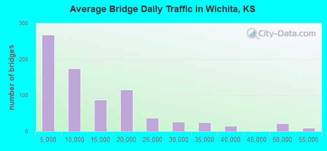
- 9,470,559Total average daily traffic
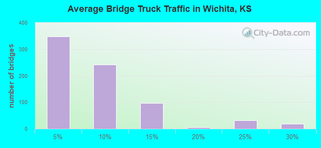
- 625,083Total average daily truck traffic
- National Bridge Inventory (NBI) Registered Bridges for Wichita
- No street view available for this location
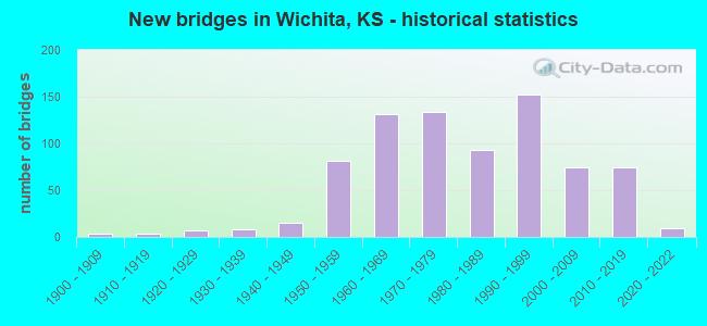
- New bridges - historical statistics
- 41900-1909
- 41910-1919
- 71920-1929
- 81930-1939
- 151940-1949
- 811950-1959
- 1311960-1969
- 1341970-1979
- 931980-1989
- 1521990-1999
- 742000-2009
- 742010-2019
- 92020-2022
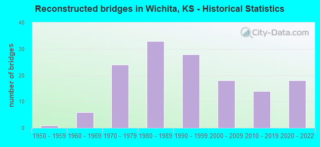
- Reconstructed bridges - Historical Statistics
- 11950-1959
- 61960-1969
- 241970-1979
- 331980-1989
- 281990-1999
- 182000-2009
- 142010-2019
- 182020-2022
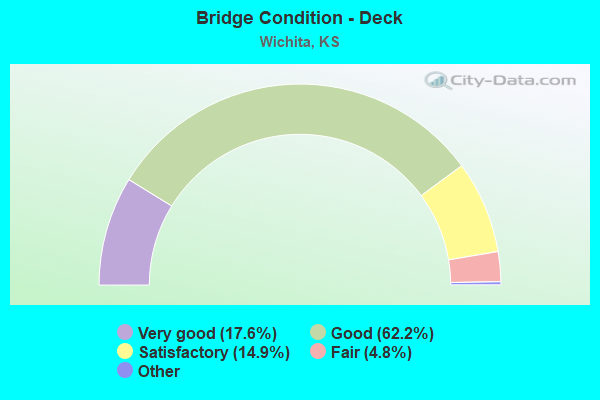
- Bridge Condition - Deck
- 17.6%Very good
- 62.2%Good
- 14.9%Satisfactory
- 4.8%Fair
- 0.5%Poor
- 0.2%Serious
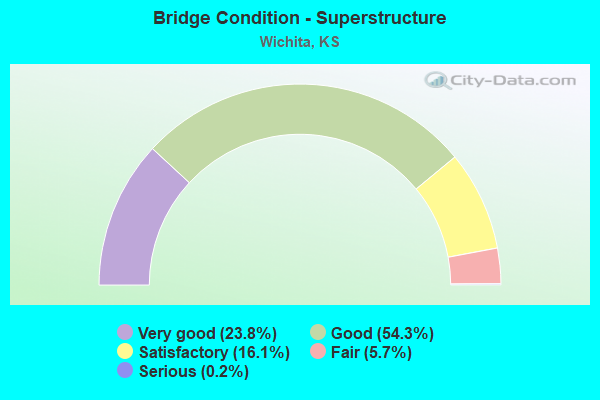
- Bridge Condition - Superstructure
- 23.8%Very good
- 54.3%Good
- 16.1%Satisfactory
- 5.7%Fair
- 0.2%Serious
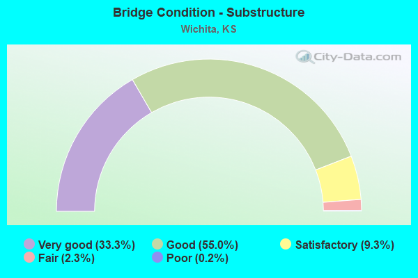
- Bridge Condition - Substructure
- 33.3%Very good
- 55.0%Good
- 9.3%Satisfactory
- 2.3%Fair
- 0.2%Poor
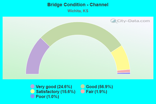
- Bridge Condition - Channel
- 24.6%Very good
- 56.9%Good
- 15.6%Satisfactory
- 1.9%Fair
- 1.0%Poor
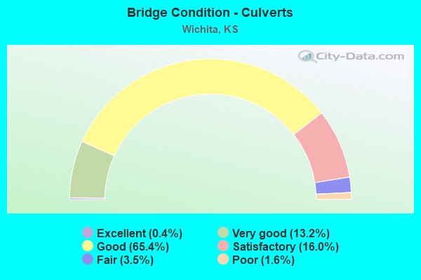
- Bridge Condition - Culverts
- 0.4%Excellent
- 13.2%Very good
- 65.4%Good
- 16.0%Satisfactory
- 3.5%Fair
- 1.6%Poor
Find on map >> Show street view
Structure Number: 8707754064, Location: 87thS, 0.4 E of 359thW (Lat: 37.532697, Lng: -97.763297), Route carried "on" structure: County highway , Year Built: 2004, Status: Open, Structure Length: 0.96m (3.15ft), Average Daily Traffic: 40 (year 2018), Average Future Daily Traffic: 60 (year 2038), Design Load: HS 20, Features Intersected: JOCELYN CREEK, Facility Carried by Structure: 87th St S LOC RD.
Minimum Vertical Clearance: 30.47m (99.97ft), Kilometerpoint: 0.000, Lanes on structure: 2, Owner: County Highway Agency, Approaching Roadway Width: 8.5m (27.9ft), Material/Design: Concrete, Design/Construction: Culvert, Number Of Spans In Main Unit: 3, Length of Maximum Span: 3.0m (9.8ft), Curb-To-Curb Width: 8.5m (27.9ft), Out-to-Out Width: 9.0m (29.5ft)
Condition: Channel: Satisfactory, Culverts: Very good, Operating Rating: 72.8 metric tons, Method Used To Determine Operating Rating: Load Factor (LF), Inventory Rating: 43.6 metric tons, Method Used To Determine Inventory Rating: Load Factor (LF), Structural Evaluation: Equal to present desirable criteria, Deck Geometry: Better than present minimum criteria, Waterway Adequacy: Somewhat better than minimum adequacy, Approach Roadway Alignment: Equal to present desirable criteria, Designated Inspection Frequency: Every 24 months, Inspection Date: March 2020, Other Special Inspection Date: Febuary 2021, Deck Structure Type: Concrete Cast-file-Place, Wearing Surface/Protective System: Wearing Surface: Gravel
Find on map >> Show street view
Structure Number: 870777006383, Location: 343rdW, 0.7 N of 87thS (Lat: 37.543356, Lng: -97.734875), Route carried "on" structure: County highway , Year Built: 1992, Year Reconstructed: 1996, Status: Open, Structure Length: 2.90m (9.51ft), Average Daily Traffic: 20 (year 2018), Average Future Daily Traffic: 35 (year 2038), Design Load: HS 20, Features Intersected: JOCELYN CREEK, Facility Carried by Structure: 343rd St N LOC RD.
Minimum Vertical Clearance: 30.47m (99.97ft), Kilometerpoint: 0.000, Lanes on structure: 2, Owner: County Highway Agency, Approaching Roadway Width: 8.2m (26.9ft), Material/Design: Wood or Timber, Design/Construction: Slab, Number Of Spans In Main Unit: 5, Length of Maximum Span: 5.8m (19.0ft), Curb-To-Curb Width: 8.3m (27.2ft), Out-to-Out Width: 8.6m (28.2ft)
Condition: Deck: Good, Superstructure: Good, Substructure: Good, Channel: Good, Operating Rating: 90.5 metric tons, Method Used To Determine Operating Rating: Allowable Stress (AS), Inventory Rating: 70.0 metric tons, Method Used To Determine Inventory Rating: Allowable Stress (AS), Structural Evaluation: Better than present minimum criteria, Deck Geometry: Equal to present minimum criteria, Waterway Adequacy: Better than present minimum criteria, Approach Roadway Alignment: Equal to present minimum criteria, Designated Inspection Frequency: Every 24 months, Inspection Date: March 2020, Deck Structure Type: Wood or Timber, Wearing Surface/Protective System: Wearing Surface: Gravel
Find on map >> Show street view
Structure Number: 870777006429, Location: 343rdW, 0.1 N of 103rdS (Lat: 37.504892, Lng: -97.734300), Route carried "on" structure: County highway , Year Built: 1986, Status: Open, Structure Length: 6.92m (22.70ft), Average Daily Traffic: 20 (year 2018), Average Future Daily Traffic: 35 (year 2038), Design Load: HS 20, Features Intersected: SAND CREEK, Facility Carried by Structure: 343st W LOCAL RD.
Minimum Vertical Clearance: 30.47m (99.97ft), Kilometerpoint: 0.000, Lanes on structure: 2, Owner: County Highway Agency, Approaching Roadway Width: 8.5m (27.9ft), Skew: 3 degrees, Material/Design: Prestressed concrete continuous, Design/Construction: Tee Beam, Number Of Spans In Main Unit: 5, Length of Maximum Span: 13.7m (44.9ft), Curb-To-Curb Width: 8.5m (27.9ft), Out-to-Out Width: 9.1m (29.9ft)
Condition: Deck: Good, Superstructure: Very good, Substructure: Very good, Channel: Good, Operating Rating: 40.5 metric tons, Method Used To Determine Operating Rating: Load Factor (LF), Inventory Rating: 32.4 metric tons, Method Used To Determine Inventory Rating: Load Factor (LF), Structural Evaluation: Equal to present desirable criteria, Deck Geometry: Better than present minimum criteria, Waterway Adequacy: Equal to present minimum criteria, Approach Roadway Alignment: Equal to present desirable criteria, Designated Inspection Frequency: Every 24 months, Inspection Date: April 2020, Deck Structure Type: Concrete Cast-file-Place, Wearing Surface/Protective System: Wearing Surface: Monolithic Concrete
Find on map >> Show street view
Structure Number: 87077730638, Location: 79thS, 0.3 E of 343rdW (Lat: 37.547139, Lng: -97.746022), Route carried "on" structure: County highway , Year Built: 1990, Status: Open, Structure Length: 3.60m (11.81ft), Average Daily Traffic: 40 (year 2018), Average Future Daily Traffic: 60 (year 2038), Design Load: HS 20, Features Intersected: JOCELYN CREEK, Facility Carried by Structure: 79th S LOCAL RD.
Minimum Vertical Clearance: 30.47m (99.97ft), Kilometerpoint: 0.000, Lanes on structure: 2, Owner: County Highway Agency, Approaching Roadway Width: 8.5m (27.9ft), Material/Design: Concrete continuous, Design/Construction: Slab, Number Of Spans In Main Unit: 3, Length of Maximum Span: 13.7m (44.9ft), Curb-To-Curb Width: 8.5m (27.9ft), Out-to-Out Width: 9.1m (29.9ft)
Condition: Deck: Good, Superstructure: Very good, Substructure: Good, Channel: Good, Operating Rating: 68.4 metric tons, Method Used To Determine Operating Rating: Load Factor (LF), Inventory Rating: 40.9 metric tons, Method Used To Determine Inventory Rating: Load Factor (LF), Structural Evaluation: Better than present minimum criteria, Deck Geometry: Better than present minimum criteria, Waterway Adequacy: Equal to present desirable criteria, Approach Roadway Alignment: Equal to present desirable criteria, Designated Inspection Frequency: Every 24 months, Inspection Date: April 2020, Other Special Inspection Date: Febuary 2021, Deck Structure Type: Concrete Cast-file-Place, Wearing Surface/Protective System: Wearing Surface: Monolithic Concrete, Deck Protection: Epoxy Coated Reinforcing
Find on map >> Show street view
Structure Number: 87077730648, Location: 119thS, 0.3 E of 343rdW (Lat: 37.474417, Lng: -97.728861), Route carried "on" structure: County highway , Year Built: 1994, Status: Open, Structure Length: 0.85m (2.79ft), Average Daily Traffic: 30 (year 2018), Average Future Daily Traffic: 50 (year 2038), Design Load: HS 20, Features Intersected: SMALL STREAM, Facility Carried by Structure: LOCAL RD.
Minimum Vertical Clearance: 30.47m (99.97ft), Kilometerpoint: 0.000, Lanes on structure: 2, Owner: County Highway Agency, Approaching Roadway Width: 7.0m (23.0ft), Material/Design: Concrete, Design/Construction: Culvert, Number Of Spans In Main Unit: 5, Length of Maximum Span: 1.2m (3.9ft), Curb-To-Curb Width: 6.1m (20.0ft), Out-to-Out Width: 8.7m (28.5ft)
Condition: Channel: Good, Culverts: Very good, Operating Rating: 40.5 metric tons, Method Used To Determine Operating Rating: Load Factor (LF), Inventory Rating: 32.4 metric tons, Method Used To Determine Inventory Rating: Load Factor (LF), Structural Evaluation: Equal to present desirable criteria, Deck Geometry: Somewhat better than minimum adequacy, Waterway Adequacy: Equal to present desirable criteria, Approach Roadway Alignment: Equal to present desirable criteria, Designated Inspection Frequency: Every 24 months, Inspection Date: April 2020, Deck Structure Type: Other, Wearing Surface/Protective System: Wearing Surface: Gravel
Find on map >> Show street view
Structure Number: 8707779064, Location: 87thS, 0.9 E of 343rdW (Lat: 37.532736, Lng: -97.716869), Route carried "on" structure: County highway , Year Built: 1999, Status: Open, Structure Length: 0.96m (3.15ft), Average Daily Traffic: 50 (year 2018), Average Future Daily Traffic: 80 (year 2038), Design Load: HS 20, Features Intersected: TRIB. TO SAND CREEK, Facility Carried by Structure: 87th St S LOC RD.
Minimum Vertical Clearance: 30.47m (99.97ft), Kilometerpoint: 0.000, Lanes on structure: 2, Owner: County Highway Agency, Approaching Roadway Width: 8.5m (27.9ft), Material/Design: Concrete, Design/Construction: Culvert, Number Of Spans In Main Unit: 3, Length of Maximum Span: 3.0m (9.8ft), Curb-To-Curb Width: 8.5m (27.9ft), Out-to-Out Width: 9.0m (29.5ft)
Condition: Channel: Good, Culverts: Very good, Operating Rating: 69.0 metric tons, Method Used To Determine Operating Rating: Load Factor (LF), Inventory Rating: 41.3 metric tons, Method Used To Determine Inventory Rating: Load Factor (LF), Structural Evaluation: Equal to present desirable criteria, Deck Geometry: Better than present minimum criteria, Waterway Adequacy: Equal to present desirable criteria, Approach Roadway Alignment: Equal to present desirable criteria, Designated Inspection Frequency: Every 24 months, Inspection Date: March 2020, Other Special Inspection Date: Febuary 2021, Deck Structure Type: Concrete Cast-file-Place, Wearing Surface/Protective System: Wearing Surface: Monolithic Concrete
Find on map >> Show street view
Structure Number: 870779006365, Location: 327thW, 0.5 N of 79thS (Lat: 37.554461, Lng: -97.733289), Route carried "on" structure: County highway , Year Built: 1970, Status: Open, Structure Length: 1.31m (4.30ft), Average Daily Traffic: 26 (year 2018), Average Future Daily Traffic: 40 (year 2038), Design Load: H 20, Features Intersected: JOCELYN CREEK, Facility Carried by Structure: 327 St W LOCAL RD.
Minimum Vertical Clearance: 30.47m (99.97ft), Kilometerpoint: 0.000, Lanes on structure: 2, Owner: County Highway Agency, Approaching Roadway Width: 9.1m (29.9ft), Material/Design: Concrete, Design/Construction: Culvert, Number Of Spans In Main Unit: 4, Length of Maximum Span: 3.4m (11.2ft), Curb-To-Curb Width: 9.7m (31.8ft), Out-to-Out Width: 10.3m (33.8ft)
Condition: Channel: Good, Culverts: Good, Operating Rating: 22.5 metric tons, Method Used To Determine Operating Rating: Load Factor (LF), Inventory Rating: 17.1 metric tons, Method Used To Determine Inventory Rating: Load Factor (LF), Structural Evaluation: Somewhat better than minimum adequacy, Deck Geometry: Better than present minimum criteria, Waterway Adequacy: Better than present minimum criteria, Approach Roadway Alignment: Better than present minimum criteria, Designated Inspection Frequency: Every 24 months, Inspection Date: March 2020, Deck Structure Type: Concrete Cast-file-Place, Wearing Surface/Protective System: Wearing Surface: Gravel
Find on map >> Show street view
Structure Number: 870779006389, Location: 327thW, 0.1 N of 87thS (Lat: 37.536361, Lng: -97.733217), Route carried "on" structure: County highway , Year Built: 1970, Status: Open, Structure Length: 0.67m (2.20ft), Average Daily Traffic: 17 (year 2018), Average Future Daily Traffic: 25 (year 2038), Design Load: H 20, Features Intersected: TRIB. TO NINNESCAH RIVER, Facility Carried by Structure: 327 St W LOCAL RD.
Minimum Vertical Clearance: 30.47m (99.97ft), Kilometerpoint: 0.000, Lanes on structure: 2, Owner: County Highway Agency, Approaching Roadway Width: 9.8m (32.2ft), Material/Design: Concrete, Design/Construction: Culvert, Number Of Spans In Main Unit: 2, Length of Maximum Span: 3.0m (9.8ft), Curb-To-Curb Width: 9.8m (32.2ft), Out-to-Out Width: 10.4m (34.1ft)
Condition: Channel: Good, Culverts: Good, Operating Rating: 22.5 metric tons, Method Used To Determine Operating Rating: Load Factor (LF), Inventory Rating: 17.1 metric tons, Method Used To Determine Inventory Rating: Load Factor (LF), Structural Evaluation: Somewhat better than minimum adequacy, Deck Geometry: Equal to present desirable criteria, Waterway Adequacy: Better than present minimum criteria, Approach Roadway Alignment: Equal to present desirable criteria, Designated Inspection Frequency: Every 24 months, Inspection Date: March 2020, Deck Structure Type: Concrete Cast-file-Place, Wearing Surface/Protective System: Wearing Surface: Gravel
Find on map >> Show street view
Structure Number: 870779006402, Location: 327thW, 0.8 N of 95thS (Lat: 37.529883, Lng: -97.733089), Route carried "on" structure: County highway , Year Built: 1989, Status: Open, Structure Length: 7.19m (23.59ft), Average Daily Traffic: 12 (year 2018), Average Future Daily Traffic: 25 (year 2038), Design Load: HS 20, Features Intersected: SAND CREEK, Facility Carried by Structure: 327st W LOCAL RD.
Minimum Vertical Clearance: 30.47m (99.97ft), Kilometerpoint: 0.000, Lanes on structure: 2, Owner: County Highway Agency, Approaching Roadway Width: 8.5m (27.9ft), Skew: 3 degrees, Material/Design: Prestressed concrete continuous, Design/Construction: Tee Beam, Number Of Spans In Main Unit: 6, Length of Maximum Span: 11.9m (39.0ft), Curb-To-Curb Width: 8.5m (27.9ft), Out-to-Out Width: 9.1m (29.9ft)
Condition: Deck: Good, Superstructure: Good, Substructure: Very good, Channel: Good, Operating Rating: 40.5 metric tons, Method Used To Determine Operating Rating: Load Factor (LF), Inventory Rating: 32.4 metric tons, Method Used To Determine Inventory Rating: Load Factor (LF), Structural Evaluation: Better than present minimum criteria, Deck Geometry: Better than present minimum criteria, Waterway Adequacy: Better than present minimum criteria, Approach Roadway Alignment: Equal to present desirable criteria, Designated Inspection Frequency: Every 24 months, Inspection Date: March 2020, Deck Structure Type: Concrete Cast-file-Place, Wearing Surface/Protective System: Wearing Surface: Monolithic Concrete, Deck Protection: Epoxy Coated Reinforcing
Find on map >> Show street view
Structure Number: 870779006465, Location: 327thW, 0.5 N of 119thS (Lat: 37.481028, Lng: -97.716000), Route carried "on" structure: County highway , Year Built: 1986, Status: Open, Structure Length: 0.82m (2.69ft), Average Daily Traffic: 12 (year 2018), Average Future Daily Traffic: 20 (year 2038), Design Load: H 20, Features Intersected: TRIB. TO NINNESCAH RIVER, Facility Carried by Structure: 327st W LOCAL RD.
Minimum Vertical Clearance: 30.47m (99.97ft), Kilometerpoint: 0.000, Lanes on structure: 2, Owner: County Highway Agency, Approaching Roadway Width: 6.7m (22.0ft), Material/Design: Wood or Timber, Design/Construction: Slab, Number Of Spans In Main Unit: 1, Length of Maximum Span: 7.9m (25.9ft), Curb-To-Curb Width: 6.7m (22.0ft), Out-to-Out Width: 6.7m (22.0ft)
Condition: Deck: Very good, Superstructure: Very good, Substructure: Very good, Channel: Satisfactory, Operating Rating: 69.3 metric tons, Method Used To Determine Operating Rating: Allowable Stress (AS), Inventory Rating: 50.3 metric tons, Method Used To Determine Inventory Rating: Allowable Stress (AS), Structural Evaluation: Equal to present desirable criteria, Deck Geometry: Somewhat better than minimum adequacy, Waterway Adequacy: Equal to present minimum criteria, Approach Roadway Alignment: Equal to present minimum criteria, Designated Inspection Frequency: Every 24 months, Inspection Date: April 2020, Deck Structure Type: Wood or Timber, Wearing Surface/Protective System: Wearing Surface: Gravel
Find on map >> Show street view
Structure Number: 87077930642, Location: 95thS, 0.3 E of 327thW (Lat: 37.518239, Lng: -97.725133), Route carried "on" structure: County highway , Year Built: 1993, Status: Open, Structure Length: 0.85m (2.79ft), Average Daily Traffic: 10 (year 2018), Average Future Daily Traffic: 20 (year 2038), Design Load: HS 20, Features Intersected: TRIB. TO NINNESCAH RIVER, Facility Carried by Structure: 95th S LOCAL RD.
Minimum Vertical Clearance: 30.47m (99.97ft), Kilometerpoint: 0.000, Lanes on structure: 2, Owner: County Highway Agency, Approaching Roadway Width: 8.5m (27.9ft), Material/Design: Concrete, Design/Construction: Culvert, Number Of Spans In Main Unit: 3, Length of Maximum Span: 2.7m (8.9ft), Curb-To-Curb Width: 8.5m (27.9ft), Out-to-Out Width: 9.0m (29.5ft)
Condition: Channel: Good, Culverts: Good, Operating Rating: 70.4 metric tons, Method Used To Determine Operating Rating: Load Factor (LF), Inventory Rating: 42.2 metric tons, Method Used To Determine Inventory Rating: Load Factor (LF), Structural Evaluation: Better than present minimum criteria, Deck Geometry: Better than present minimum criteria, Waterway Adequacy: Equal to present desirable criteria, Approach Roadway Alignment: Equal to present desirable criteria, Designated Inspection Frequency: Every 24 months, Inspection Date: April 2020, Other Special Inspection Date: Febuary 2021, Deck Structure Type: Concrete Cast-file-Place, Wearing Surface/Protective System: Wearing Surface: Gravel
Find on map >> Show street view
Structure Number: 87077970646, Location: 111thS, 0.7 E of 327thW (Lat: 37.489072, Lng: -97.703367), Route carried "on" structure: County highway 8702, Year Built: 1963, Status: Open, Structure Length: 0.79m (2.59ft), Average Daily Traffic: 21 (year 2018), Truck Traffic: 24%, Average Future Daily Traffic: 50 (year 2038), Design Load: H 20, Features Intersected: TRIB. TO NINNESCAH RIVER, Facility Carried by Structure: 111st S MINOR COL
Minimum Vertical Clearance: 30.47m (99.97ft), Kilometerpoint: 0.000, Lanes on structure: 2, Owner: County Highway Agency, Approaching Roadway Width: 11.6m (38.1ft), Material/Design: Concrete, Design/Construction: Culvert, Number Of Spans In Main Unit: 3, Length of Maximum Span: 2.7m (8.9ft), Curb-To-Curb Width: 9.2m (30.2ft), Out-to-Out Width: 10.1m (33.1ft)
Condition: Channel: Satisfactory, Culverts: Fair, Operating Rating: 27.9 metric tons, Method Used To Determine Operating Rating: Load Factor (LF), Inventory Rating: 22.5 metric tons, Method Used To Determine Inventory Rating: Load Factor (LF), Structural Evaluation: Somewhat better than minimum adequacy, Deck Geometry: Better than present minimum criteria, Waterway Adequacy: Better than present minimum criteria, Approach Roadway Alignment: Better than present minimum criteria, Designated Inspection Frequency: Every 24 months, Inspection Date: April 2020, Deck Structure Type: Concrete Cast-file-Place, Wearing Surface/Protective System: Wearing Surface: Monolithic Concrete
Find on map >> Show street view
Structure Number: 87077990638, Location: 79thS, 0.9 E of 327thW (Lat: 37.547269, Lng: -97.701150), Route carried "on" structure: County highway , Year Built: 1991, Status: Open, Structure Length: 9.42m (30.91ft), Average Daily Traffic: 30 (year 2018), Average Future Daily Traffic: 50 (year 2038), Design Load: HS 20, Features Intersected: JOCELYN CREEK, Facility Carried by Structure: 79 St S LOCAL RD.
Minimum Vertical Clearance: 30.47m (99.97ft), Kilometerpoint: 0.000, Lanes on structure: 2, Owner: County Highway Agency, Approaching Roadway Width: 8.5m (27.9ft), Skew: 4 degrees, Material/Design: Concrete continuous, Design/Construction: Slab, Number Of Spans In Main Unit: 6, Length of Maximum Span: 16.8m (55.1ft), Curb-To-Curb Width: 8.5m (27.9ft), Out-to-Out Width: 9.1m (29.9ft)
Condition: Deck: Good, Superstructure: Good, Substructure: Good, Channel: Good, Operating Rating: 70.5 metric tons, Method Used To Determine Operating Rating: Load Factor (LF), Inventory Rating: 42.2 metric tons, Method Used To Determine Inventory Rating: Load Factor (LF), Structural Evaluation: Better than present minimum criteria, Deck Geometry: Better than present minimum criteria, Waterway Adequacy: Equal to present minimum criteria, Approach Roadway Alignment: Better than present minimum criteria, Designated Inspection Frequency: Every 24 months, Inspection Date: April 2020, Other Special Inspection Date: Febuary 2021, Deck Structure Type: Concrete Cast-file-Place, Wearing Surface/Protective System: Wearing Surface: Monolithic Concrete
Find on map >> Show street view
Structure Number: 870781006369, Location: 311thW, 0.1 N of 79thS (Lat: 37.548944, Lng: -97.698250), Route carried "on" structure: County highway , Year Built: 1991, Status: Open, Structure Length: 6.37m (20.90ft), Average Daily Traffic: 50 (year 2018), Average Future Daily Traffic: 80 (year 2038), Design Load: HS 20, Features Intersected: JOCELYN CREEK, Facility Carried by Structure: LOCAL RD.
Minimum Vertical Clearance: 30.47m (99.97ft), Kilometerpoint: 0.000, Lanes on structure: 2, Owner: County Highway Agency, Approaching Roadway Width: 8.5m (27.9ft), Skew: 3 degrees, Material/Design: Prestressed concrete continuous, Design/Construction: Slab, Number Of Spans In Main Unit: 3, Length of Maximum Span: 24.7m (81.0ft), Curb-To-Curb Width: 8.5m (27.9ft), Out-to-Out Width: 9.1m (29.9ft)
Condition: Deck: Good, Superstructure: Good, Substructure: Very good, Channel: Good, Operating Rating: 40.5 metric tons, Method Used To Determine Operating Rating: Load Factor (LF), Inventory Rating: 32.4 metric tons, Method Used To Determine Inventory Rating: Load Factor (LF), Structural Evaluation: Better than present minimum criteria, Deck Geometry: Better than present minimum criteria, Waterway Adequacy: Better than present minimum criteria, Approach Roadway Alignment: Equal to present desirable criteria, Designated Inspection Frequency: Every 24 months, Inspection Date: April 2020, Deck Structure Type: Concrete Cast-file-Place, Wearing Surface/Protective System: Wearing Surface: Monolithic Concrete
Find on map >> Show street view
Structure Number: 870781006424, Location: 311thW, 0.7N OF 103rdS (Lat: 37.512561, Lng: -97.697969), Route carried "on" structure: County highway 3035, Year Built: 2017, Status: Open, Structure Length: 0.79m (2.59ft), Average Daily Traffic: 20 (year 2018), Average Future Daily Traffic: 30 (year 2038), Design Load: HS 20, Features Intersected: TRIB. TO NINNESCAH RIVER, Facility Carried by Structure: 311thW LOCAL RD
Minimum Vertical Clearance: 30.47m (99.97ft), Kilometerpoint: 0.000, Lanes on structure: 2, Owner: County Highway Agency, Approaching Roadway Width: 6.7m (22.0ft), Material/Design: Concrete, Design/Construction: Culvert, Number Of Spans In Main Unit: 3, Length of Maximum Span: 2.4m (7.9ft), Curb-To-Curb Width: 8.6m (28.2ft), Out-to-Out Width: 9.2m (30.2ft)
Condition: Channel: Very good, Culverts: Very good, Operating Rating: 43.5 metric tons, Method Used To Determine Operating Rating: Load Factor (LF), Inventory Rating: 32.7 metric tons, Method Used To Determine Inventory Rating: Load Factor (LF), Structural Evaluation: Equal to present desirable criteria, Deck Geometry: Better than present minimum criteria, Waterway Adequacy: Equal to present desirable criteria, Approach Roadway Alignment: Equal to present desirable criteria, Designated Inspection Frequency: Every 24 months, Inspection Date: April 2020, Deck Structure Type: Concrete Cast-file-Place, Wearing Surface/Protective System: Wearing Surface: Gravel
Find on map >> Show street view
Structure Number: 870781006447, Location: 311thW, 0.3 N of 111thS (Lat: 37.493267, Lng: -97.714522), Route carried "on" structure: County highway , Year Built: 1900, Status: Open, Structure Length: 0.79m (2.59ft), Average Daily Traffic: 12 (year 2018), Average Future Daily Traffic: 20 (year 2038), Features Intersected: TRIB. TO NINNESCAH RIVER, Facility Carried by Structure: 311st W LOCAL RD.
Minimum Vertical Clearance: 30.47m (99.97ft), Kilometerpoint: 0.000, Lanes on structure: 2, Owner: County Highway Agency, Approaching Roadway Width: 8.2m (26.9ft), Material/Design: Concrete, Design/Construction: Culvert, Number Of Spans In Main Unit: 3, Length of Maximum Span: 2.7m (8.9ft), Curb-To-Curb Width: 9.1m (29.9ft), Out-to-Out Width: 9.8m (32.2ft)
Condition: Channel: Good, Culverts: Fair, Operating Rating: 22.5 metric tons, Method Used To Determine Operating Rating: Load Factor (LF), Inventory Rating: 17.1 metric tons, Method Used To Determine Inventory Rating: Load Factor (LF), Structural Evaluation: Somewhat better than minimum adequacy, Deck Geometry: Better than present minimum criteria, Waterway Adequacy: Equal to present minimum criteria, Approach Roadway Alignment: Better than present minimum criteria, Designated Inspection Frequency: Every 24 months, Inspection Date: April 2020, Deck Structure Type: Concrete Cast-file-Place, Wearing Surface/Protective System: Wearing Surface: Monolithic Concrete
Find on map >> Show street view
Structure Number: 87078110644, Location: 103rd S, 0.2 E of 311th W (Lat: 37.503611, Lng: -97.694219), Route carried "on" structure: County highway 3037, Year Built: 2016, Status: Open, Structure Length: 2.25m (7.38ft), Average Daily Traffic: 15 (year 2018), Average Future Daily Traffic: 30 (year 2038), Design Load: HL 93, Features Intersected: TRIB. TO NINNESCAH RIVER, Facility Carried by Structure: LOCAL RD 103rd S
Minimum Vertical Clearance: 30.47m (99.97ft), Kilometerpoint: 0.000, Lanes on structure: 2, Owner: County Highway Agency, Approaching Roadway Width: 5.9m (19.4ft), Skew: 4 degrees, Material/Design: Concrete, Design/Construction: Culvert, Number Of Spans In Main Unit: 5, Length of Maximum Span: 4.4m (14.4ft), Curb-To-Curb Width: 11.2m (36.7ft), Out-to-Out Width: 11.5m (37.7ft)
Condition: Channel: Good, Culverts: Very good, Operating Rating: 43.5 metric tons, Method Used To Determine Operating Rating: Load and Resistance Factor (LRFR), Inventory Rating: 32.7 metric tons, Method Used To Determine Inventory Rating: Load and Resistance Factor (LRFR), Structural Evaluation: Equal to present desirable criteria, Deck Geometry: Superior to present desirable criteria, Waterway Adequacy: Equal to present minimum criteria, Approach Roadway Alignment: Equal to present desirable criteria, Designated Inspection Frequency: Every 24 months, Inspection Date: April 2020, Deck Structure Type: Concrete Cast-file-Place, Wearing Surface/Protective System: Wearing Surface: Gravel, Deck Protection: Epoxy Coated Reinforcing
Find on map >> Show street view
Structure Number: 87078150642, Location: 95thS, 0.4 E of 311thW (Lat: 37.518281, Lng: -97.690461), Route carried "on" structure: County highway , Year Built: 1993, Status: Open, Structure Length: 4.36m (14.30ft), Average Daily Traffic: 30 (year 2018), Average Future Daily Traffic: 50 (year 2038), Design Load: HS 20, Features Intersected: TRIB. TO NINNESCAH RIVER, Facility Carried by Structure: 95th S
Minimum Vertical Clearance: 30.47m (99.97ft), Kilometerpoint: 0.000, Lanes on structure: 2, Owner: County Highway Agency, Approaching Roadway Width: 8.5m (27.9ft), Material/Design: Concrete continuous, Design/Construction: Slab, Number Of Spans In Main Unit: 3, Length of Maximum Span: 16.8m (55.1ft), Curb-To-Curb Width: 8.5m (27.9ft), Out-to-Out Width: 9.1m (29.9ft)
Condition: Deck: Good, Superstructure: Very good, Substructure: Very good, Channel: Very good, Operating Rating: 68.6 metric tons, Method Used To Determine Operating Rating: Load Factor (LF), Inventory Rating: 41.0 metric tons, Method Used To Determine Inventory Rating: Load Factor (LF), Structural Evaluation: Equal to present desirable criteria, Deck Geometry: Better than present minimum criteria, Waterway Adequacy: Better than present minimum criteria, Approach Roadway Alignment: Equal to present desirable criteria, Designated Inspection Frequency: Every 24 months, Inspection Date: April 2020, Other Special Inspection Date: Febuary 2021, Deck Structure Type: Concrete Cast-file-Place, Wearing Surface/Protective System: Wearing Surface: Monolithic Concrete
Find on map >> Show street view
Structure Number: 8707817064, Location: 87thS, 0.6 E of 311thW (Lat: 37.532917, Lng: -97.685889), Route carried "on" structure: Other road 3031, Year Built: 2015, Status: Open, Structure Length: 0.95m (3.12ft), Average Daily Traffic: 40 (year 2018), Average Future Daily Traffic: 60 (year 2038), Design Load: HS 20, Features Intersected: TRIB TO NINNESCAH, Facility Carried by Structure: 87th S LOCAL RD.
Minimum Vertical Clearance: 30.47m (99.97ft), Kilometerpoint: 0.000, Lanes on structure: 2, Owner: County Highway Agency, Approaching Roadway Width: 5.7m (18.7ft), Material/Design: Concrete, Design/Construction: Culvert, Number Of Spans In Main Unit: 3, Length of Maximum Span: 3.0m (9.8ft), Curb-To-Curb Width: 13.4m (44.0ft), Out-to-Out Width: 13.8m (45.3ft)
Condition: Channel: Very good, Culverts: Very good, Operating Rating: 43.5 metric tons, Method Used To Determine Operating Rating: Load Factor (LF), Inventory Rating: 32.7 metric tons, Method Used To Determine Inventory Rating: Load Factor (LF), Structural Evaluation: Equal to present desirable criteria, Deck Geometry: Superior to present desirable criteria, Waterway Adequacy: Somewhat better than minimum adequacy, Approach Roadway Alignment: Equal to present desirable criteria, Designated Inspection Frequency: Every 24 months, Inspection Date: April 2020, Deck Structure Type: Concrete Cast-file-Place, Wearing Surface/Protective System: Wearing Surface: Gravel, Deck Protection: Epoxy Coated Reinforcing
Find on map >> Show street view
Structure Number: 87079920612, Location: 29thN, 0.1 E of 167thW (Lat: 37.736119, Lng: -97.532514), Route carried "on" structure: County highway , Year Built: 1970, Status: Posted for load, Structure Length: 0.70m (2.30ft), Average Daily Traffic: 1,690 (year 2018), Truck Traffic: 3%, Average Future Daily Traffic: 2,062 (year 2038), Design Load: H 20, Features Intersected: TRIB. TO COWSKIN CREEK, Facility Carried by Structure: W 29th LOCAL RD.
Minimum Vertical Clearance: 30.47m (99.97ft), Kilometerpoint: 0.000, Lanes on structure: 2, Owner: County Highway Agency, Approaching Roadway Width: 7.3m (24.0ft), Material/Design: Steel, Design/Construction: Culvert, Number Of Spans In Main Unit: 3, Length of Maximum Span: 1.8m (5.9ft), Curb-To-Curb Width: 7.3m (24.0ft), Out-to-Out Width: 7.3m (24.0ft)
Condition: Channel: Satisfactory, Culverts: Poor, Operating Rating: 16.3 metric tons, Method Used To Determine Operating Rating: Load Factor (LF), Inventory Rating: 9.8 metric tons, Method Used To Determine Inventory Rating: Load Factor (LF), Structural Evaluation: High priority of replacement, Deck Geometry: Meets minimum limits, Waterway Adequacy: Somewhat better than minimum adequacy, Approach Roadway Alignment: Better than present minimum criteria, Bridge Posting: Required (Relationship of Operating Rating to Maximum Legal Load: > 39.9% below), Length Of Structure Improvement: 2.13m (6.99ft), Designated Inspection Frequency: Every 24 months, Inspection Date: July 2021, Bridge Improvement Cost: $80,000, Roadway Improvement Cost: $20,000, Total Project Cost: $100,000 ( Estimate for 2018), Deck Structure Type: Other, Wearing Surface/Protective System: Wearing Surface: Bituminous
Find on map >> Show street view
Structure Number: 8707995063, Location: 47thS, 0.5 E of 167thW (Lat: 37.606222, Lng: -97.524386), Route carried "on" structure: County highway , Year Built: 1987, Status: Open, Structure Length: 1.98m (6.50ft), Average Daily Traffic: 40 (year 2018), Average Future Daily Traffic: 60 (year 2038), Design Load: H 20, Features Intersected: DRY CREEK, Facility Carried by Structure: 47th LOCAL RD.
Minimum Vertical Clearance: 30.47m (99.97ft), Kilometerpoint: 0.000, Lanes on structure: 2, Owner: County Highway Agency, Approaching Roadway Width: 8.5m (27.9ft), Material/Design: Concrete, Design/Construction: Culvert, Number Of Spans In Main Unit: 5, Length of Maximum Span: 3.7m (12.1ft), Curb-To-Curb Width: 8.5m (27.9ft), Out-to-Out Width: 9.1m (29.9ft)
Condition: Channel: Good, Culverts: Good, Operating Rating: 45.1 metric tons, Method Used To Determine Operating Rating: Load Factor (LF), Inventory Rating: 27.0 metric tons, Method Used To Determine Inventory Rating: Load Factor (LF), Structural Evaluation: Equal to present minimum criteria, Deck Geometry: Better than present minimum criteria, Waterway Adequacy: Equal to present desirable criteria, Approach Roadway Alignment: Better than present minimum criteria, Designated Inspection Frequency: Every 24 months, Inspection Date: July 2020, Other Special Inspection Date: Febuary 2021, Deck Structure Type: Concrete Cast-file-Place, Wearing Surface/Protective System: Wearing Surface: Gravel
Find on map >> Show street view
Structure Number: 87079960616, Location: 13thN, 0.6 E of 167thW (Lat: 37.707300, Lng: -97.524292), Route carried "on" structure: County highway , Year Built: 2002, Status: Open, Structure Length: 5.09m (16.70ft), Average Daily Traffic: 65 (year 2018), Average Future Daily Traffic: 100 (year 2038), Design Load: HS 20, Features Intersected: DRY CREEK, Facility Carried by Structure: 13th LOCAL RD.
Minimum Vertical Clearance: 30.47m (99.97ft), Kilometerpoint: 0.000, Lanes on structure: 2, Owner: County Highway Agency, Approaching Roadway Width: 8.6m (28.2ft), Material/Design: Prestressed concrete continuous, Design/Construction: Slab, Number Of Spans In Main Unit: 3, Length of Maximum Span: 20.0m (65.6ft), Curb-To-Curb Width: 8.6m (28.2ft), Out-to-Out Width: 9.2m (30.2ft)
Condition: Deck: Very good, Superstructure: Very good, Substructure: Very good, Channel: Satisfactory, Operating Rating: 40.8 metric tons, Method Used To Determine Operating Rating: Load Factor (LF), Inventory Rating: 28.8 metric tons, Method Used To Determine Inventory Rating: Load Factor (LF), Structural Evaluation: Better than present minimum criteria, Deck Geometry: Better than present minimum criteria, Waterway Adequacy: Equal to present desirable criteria, Approach Roadway Alignment: Better than present minimum criteria, Designated Inspection Frequency: Every 24 months, Inspection Date: July 2021, Deck Structure Type: Concrete Cast-file-Place, Wearing Surface/Protective System: Wearing Surface: Monolithic Concrete
Find on map >> Show street view
Structure Number: 870801006081, Location: 151stW, 0.9 N of 37thN (Lat: 37.763300, Lng: -97.517489), Route carried "on" structure: County highway , Year Built: 1980, Status: Open, Structure Length: 0.67m (2.20ft), Average Daily Traffic: 45 (year 2018), Average Future Daily Traffic: 70 (year 2038), Design Load: H 20, Features Intersected: TRIB. TO COWSKIN CREEK, Facility Carried by Structure: 167th LOCAL RD.
Minimum Vertical Clearance: 30.47m (99.97ft), Kilometerpoint: 0.000, Lanes on structure: 2, Owner: County Highway Agency, Approaching Roadway Width: 9.8m (32.2ft), Material/Design: Concrete, Design/Construction: Culvert, Number Of Spans In Main Unit: 2, Length of Maximum Span: 3.0m (9.8ft), Curb-To-Curb Width: 9.8m (32.2ft), Out-to-Out Width: 10.2m (33.5ft)
Condition: Channel: Satisfactory, Culverts: Good, Operating Rating: 27.9 metric tons, Method Used To Determine Operating Rating: Load Factor (LF), Inventory Rating: 22.5 metric tons, Method Used To Determine Inventory Rating: Load Factor (LF), Structural Evaluation: Equal to present minimum criteria, Deck Geometry: Equal to present desirable criteria, Waterway Adequacy: Equal to present minimum criteria, Approach Roadway Alignment: Better than present minimum criteria, Designated Inspection Frequency: Every 24 months, Inspection Date: July 2021, Deck Structure Type: Concrete Cast-file-Place, Wearing Surface/Protective System: Wearing Surface: Monolithic Concrete
Find on map >> Show street view
Structure Number: 870801006129, Location: 151stW, 0.2 N of 21stN (Lat: 37.723861, Lng: -97.517111), Route carried "on" structure: County highway C6785, Year Built: 2010, Status: Open, Structure Length: 1.00m (3.28ft), Average Daily Traffic: 519 (year 2018), Truck Traffic: 3%, Average Future Daily Traffic: 633 (year 2038), Design Load: HS 20, Features Intersected: TRIB TO DRY CREEK
Minimum Vertical Clearance: 30.47m (99.97ft), Kilometerpoint: 0.000, Lanes on structure: 2, Owner: County Highway Agency, Approaching Roadway Width: 8.1m (26.6ft), Material/Design: Concrete, Design/Construction: Culvert, Number Of Spans In Main Unit: 3, Length of Maximum Span: 3.0m (9.8ft), Curb-To-Curb Width: 11.8m (38.7ft), Out-to-Out Width: 12.2m (40.0ft)
Condition: Channel: Very good, Culverts: Very good, Operating Rating: 43.5 metric tons, Method Used To Determine Operating Rating: Load Factor (LF), Inventory Rating: 32.7 metric tons, Method Used To Determine Inventory Rating: Load Factor (LF), Structural Evaluation: Equal to present desirable criteria, Deck Geometry: Better than present minimum criteria, Waterway Adequacy: Equal to present desirable criteria, Approach Roadway Alignment: Equal to present desirable criteria, Designated Inspection Frequency: Every 24 months, Inspection Date: August 2021, Deck Structure Type: Concrete Cast-file-Place, Wearing Surface/Protective System: Wearing Surface: Bituminous
Find on map >> Show street view
Structure Number: 87080100616, Location: 13thN, 0.03 E of 151stW (Lat: 37.707408, Lng: -97.517083), Route carried "on" structure: County highway , Year Built: 2003, Status: Open, Structure Length: 5.09m (16.70ft), Average Daily Traffic: 80 (year 2018), Average Future Daily Traffic: 120 (year 2038), Design Load: HS 20, Features Intersected: DRY CREEK, Facility Carried by Structure: 13th LOCAL RD.
Minimum Vertical Clearance: 30.47m (99.97ft), Kilometerpoint: 0.000, Lanes on structure: 2, Owner: County Highway Agency, Approaching Roadway Width: 8.6m (28.2ft), Material/Design: Prestressed concrete continuous, Design/Construction: Slab, Number Of Spans In Main Unit: 3, Length of Maximum Span: 20.0m (65.6ft), Curb-To-Curb Width: 8.6m (28.2ft), Out-to-Out Width: 9.2m (30.2ft)
Condition: Deck: Very good, Superstructure: Very good, Substructure: Very good, Channel: Satisfactory, Operating Rating: 40.8 metric tons, Method Used To Determine Operating Rating: Load Factor (LF), Inventory Rating: 28.8 metric tons, Method Used To Determine Inventory Rating: Load Factor (LF), Structural Evaluation: Better than present minimum criteria, Deck Geometry: Better than present minimum criteria, Waterway Adequacy: Equal to present desirable criteria, Approach Roadway Alignment: Better than present minimum criteria, Designated Inspection Frequency: Every 24 months, Inspection Date: August 2021, Deck Structure Type: Concrete Cast-file-Place, Wearing Surface/Protective System: Wearing Surface: Monolithic Concrete
Find on map >> Show street view
Structure Number: 870801006269, Location: 3.0E 1.9S OF GODDARD (Lat: 37.622450, Lng: -97.516919), Route carried "on" structure: County highway , Year Built: 1986, Status: Open, Structure Length: 0.73m (2.40ft), Average Daily Traffic: 40 (year 2018), Average Future Daily Traffic: 60 (year 2038), Design Load: H 20, Features Intersected: TRIB. TO DRY CREEK, Facility Carried by Structure: 151st St
Minimum Vertical Clearance: 30.47m (99.97ft), Kilometerpoint: 0.000, Lanes on structure: 2, Owner: County Highway Agency, Approaching Roadway Width: 7.3m (24.0ft), Material/Design: Wood or Timber, Design/Construction: Slab, Number Of Spans In Main Unit: 1, Length of Maximum Span: 7.0m (23.0ft), Curb-To-Curb Width: 7.3m (24.0ft), Out-to-Out Width: 7.3m (24.0ft)
Condition: Deck: Satisfactory, Superstructure: Satisfactory, Substructure: Good, Channel: Satisfactory, Operating Rating: 36.5 metric tons, Method Used To Determine Operating Rating: Allowable Stress (AS), Inventory Rating: 26.9 metric tons, Method Used To Determine Inventory Rating: Allowable Stress (AS), Structural Evaluation: Equal to present minimum criteria, Deck Geometry: Equal to present minimum criteria, Waterway Adequacy: Better than present minimum criteria, Approach Roadway Alignment: Equal to present minimum criteria, Designated Inspection Frequency: Every 24 months, Inspection Date: July 2020, Deck Structure Type: Wood or Timber, Wearing Surface/Protective System: Wearing Surface: Gravel
Find on map >> Show street view
Structure Number: 870801406129, Location: 0.1N of 21st, E OF 151stW (Lat: 37.723139, Lng: -97.510219), Route carried "on" structure: County highway 67740, Year Built: 2009, Status: Open, Structure Length: 5.55m (18.21ft), Average Daily Traffic: 200 (year 2018), Truck Traffic: 2%, Average Future Daily Traffic: 300 (year 2038), Design Load: HS 20, Features Intersected: DRY CRK N OF COWSKIN CRK, Facility Carried by Structure: ST TERESA LOCAL RD
Minimum Vertical Clearance: 30.47m (99.97ft), Kilometerpoint: 0.000, Lanes on structure: 2, Owner: County Highway Agency, Approaching Roadway Width: 12.2m (40.0ft), Skew: 3 degrees, Material/Design: Concrete continuous, Design/Construction: Slab, Number Of Spans In Main Unit: 3, Length of Maximum Span: 15.8m (51.8ft), Curb or Sidewalk Widths: Left: 2.4m (7.9ft), Right: 2.4m (7.9ft), Curb-To-Curb Width: 12.3m (40.4ft), Out-to-Out Width: 18.1m (59.4ft)
Condition: Deck: Satisfactory, Superstructure: Satisfactory, Substructure: Good, Channel: Satisfactory, Operating Rating: 43.5 metric tons, Method Used To Determine Operating Rating: Load Factor (LF), Inventory Rating: 32.7 metric tons, Method Used To Determine Inventory Rating: Load Factor (LF), Structural Evaluation: Equal to present minimum criteria, Deck Geometry: Superior to present desirable criteria, Waterway Adequacy: Equal to present desirable criteria, Approach Roadway Alignment: Equal to present desirable criteria, Designated Inspection Frequency: Every 24 months, Inspection Date: August 2021, Deck Structure Type: Concrete Cast-file-Place, Wearing Surface/Protective System: Wearing Surface: Monolithic Concrete
Find on map >> Show street view
Structure Number: 87080140624, Location: 1.8W WICHITA CITY LIMITS (Lat: 37.649800, Lng: -97.525758), Route carried "on" structure: County highway , Year Built: 1989, Status: Open, Structure Length: 0.76m (2.49ft), Average Daily Traffic: 1,901 (year 2018), Truck Traffic: 3%, Average Future Daily Traffic: 2,319 (year 2038), Design Load: HS 20, Features Intersected: TRIB. TO CALFSKIN CREEK, Facility Carried by Structure: LOCAL RD.
Minimum Vertical Clearance: 30.47m (99.97ft), Kilometerpoint: 0.000, Lanes on structure: 2, Owner: County Highway Agency, Approaching Roadway Width: 8.5m (27.9ft), Material/Design: Concrete, Design/Construction: Culvert, Number Of Spans In Main Unit: 3, Length of Maximum Span: 2.4m (7.9ft), Curb-To-Curb Width: 8.5m (27.9ft), Out-to-Out Width: 9.0m (29.5ft)
Condition: Channel: Very good, Culverts: Very good, Operating Rating: 80.3 metric tons, Method Used To Determine Operating Rating: Load Factor (LF), Inventory Rating: 48.1 metric tons, Method Used To Determine Inventory Rating: Load Factor (LF), Structural Evaluation: Equal to present desirable criteria, Deck Geometry: Somewhat better than minimum adequacy, Waterway Adequacy: Better than present minimum criteria, Approach Roadway Alignment: Better than present minimum criteria, Designated Inspection Frequency: Every 24 months, Inspection Date: July 2020, Other Special Inspection Date: Febuary 2021, Deck Structure Type: Concrete Cast-file-Place, Wearing Surface/Protective System: Wearing Surface: Bituminous
Find on map >> Show street view
Structure Number: 87080160612, Location: 29thN, 0.6 E of 151stW (Lat: 37.736486, Lng: -97.504883), Route carried "on" structure: County highway , Year Built: 2009, Status: Open, Structure Length: 0.90m (2.95ft), Average Daily Traffic: 2,038 (year 2018), Truck Traffic: 3%, Average Future Daily Traffic: 2,487 (year 2038), Design Load: HS 20, Features Intersected: TRIB. TO DRY CREEK, Facility Carried by Structure: W 29th LOCAL RD.
Minimum Vertical Clearance: 30.47m (99.97ft), Kilometerpoint: 0.000, Lanes on structure: 2, Owner: County Highway Agency, Approaching Roadway Width: 7.6m (24.9ft), Material/Design: Concrete, Design/Construction: Culvert, Number Of Spans In Main Unit: 3, Length of Maximum Span: 3.0m (9.8ft), Curb-To-Curb Width: 11.5m (37.7ft), Out-to-Out Width: 11.5m (37.7ft)
Condition: Channel: Very good, Culverts: Very good, Operating Rating: 22.5 metric tons, Method Used To Determine Operating Rating: Load Factor (LF), Inventory Rating: 17.1 metric tons, Method Used To Determine Inventory Rating: Load Factor (LF), Structural Evaluation: Meets minimum limits, Deck Geometry: Somewhat better than minimum adequacy, Waterway Adequacy: Equal to present minimum criteria, Approach Roadway Alignment: Equal to present minimum criteria, Designated Inspection Frequency: Every 24 months, Inspection Date: July 2021, Deck Structure Type: Other, Wearing Surface/Protective System: Wearing Surface: Bituminous
Find on map >> Show street view
Structure Number: 87080190624, Location: 2.1W WICHITA CITY LIMITS (Lat: 37.649836, Lng: -97.500294), Route carried "on" structure: County highway , Year Built: 1993, Status: Open, Structure Length: 3.14m (10.30ft), Average Daily Traffic: 1,901 (year 2018), Truck Traffic: 3%, Average Future Daily Traffic: 2,319 (year 2038), Design Load: HS 20, Features Intersected: TRIB. TO CALFSKIN CREEK, Facility Carried by Structure: 23rd LOCAL RD.
Minimum Vertical Clearance: 30.47m (99.97ft), Kilometerpoint: 0.000, Lanes on structure: 2, Owner: County Highway Agency, Approaching Roadway Width: 8.5m (27.9ft), Skew: 3 degrees, Material/Design: Concrete continuous, Design/Construction: Slab, Number Of Spans In Main Unit: 3, Length of Maximum Span: 12.2m (40.0ft), Curb-To-Curb Width: 8.5m (27.9ft), Out-to-Out Width: 9.1m (29.9ft)
Condition: Deck: Fair, Superstructure: Satisfactory, Substructure: Good, Channel: Satisfactory, Operating Rating: 66.8 metric tons, Method Used To Determine Operating Rating: Load Factor (LF), Inventory Rating: 40.0 metric tons, Method Used To Determine Inventory Rating: Load Factor (LF), Structural Evaluation: Equal to present minimum criteria, Deck Geometry: Somewhat better than minimum adequacy, Waterway Adequacy: Better than present minimum criteria, Approach Roadway Alignment: Better than present minimum criteria, Length Of Structure Improvement: 3.14m (10.30ft), Designated Inspection Frequency: Every 24 months, Inspection Date: July 2020, Other Special Inspection Date: Febuary 2021, Bridge Improvement Cost: $300,000, Total Project Cost: $300,000 ( Estimate for 2018), Deck Structure Type: Concrete Cast-file-Place, Wearing Surface/Protective System: Wearing Surface: Monolithic Concrete
Find on map >> Show street view
Structure Number: 870803006086, Location: 135thW, 0.4 N of 37thN (Lat: 37.757003, Lng: -97.515906), Route carried "on" structure: County highway , Year Built: 1984, Status: Open, Structure Length: 3.08m (10.10ft), Average Daily Traffic: 1,455 (year 2018), Truck Traffic: 6%, Average Future Daily Traffic: 1,775 (year 2038), Design Load: HS 20, Features Intersected: COWSKIN CREEK, Facility Carried by Structure: 135th LOCAL RD.
Minimum Vertical Clearance: 30.47m (99.97ft), Kilometerpoint: 0.000, Lanes on structure: 2, Owner: County Highway Agency, Approaching Roadway Width: 7.3m (24.0ft), Material/Design: Steel continuous, Design/Construction: Stringer/Multi-beam, Number Of Spans In Main Unit: 3, Length of Maximum Span: 10.4m (34.1ft), Curb-To-Curb Width: 8.5m (27.9ft), Out-to-Out Width: 9.1m (29.9ft)
Condition: Deck: Fair, Superstructure: Fair, Substructure: Satisfactory, Channel: Satisfactory, Operating Rating: 35.6 metric tons, Method Used To Determine Operating Rating: Load Factor (LF), Inventory Rating: 21.3 metric tons, Method Used To Determine Inventory Rating: Load Factor (LF), Structural Evaluation: Somewhat better than minimum adequacy, Deck Geometry: Somewhat better than minimum adequacy, Waterway Adequacy: Equal to present minimum criteria, Approach Roadway Alignment: Better than present minimum criteria, Bridge Posting: Required (Relationship of Operating Rating to Maximum Legal Load: 10.0 - 19.9% below), Designated Inspection Frequency: Every 24 months, Other Special Inspection Frequency: Every 48 months, Inspection Date: July 2021, Other Special Inspection Date: June 2020, Deck Structure Type: Concrete Precast Panels, Wearing Surface/Protective System: Wearing Surface: Monolithic Concrete
Find on map >> Show street view
Structure Number: 870803006122, Location: 135thW, 0.7 N of 21stN (Lat: 37.732219, Lng: -97.499061), Route carried "on" structure: County highway 6787, Year Built: 2016, Status: Open, Structure Length: 5.55m (18.21ft), Average Daily Traffic: 3,222 (year 2018), Truck Traffic: 2%, Average Future Daily Traffic: 3,931 (year 2038), Design Load: HL 93, Features Intersected: DRY CREEK, Facility Carried by Structure: 135th Urb Maj Coll
Minimum Vertical Clearance: 30.47m (99.97ft), Kilometerpoint: 0.000, Lanes on structure: 2, Owner: County Highway Agency, Approaching Roadway Width: 7.9m (25.9ft), Skew: 3 degrees, Material/Design: Concrete continuous, Design/Construction: Slab, Number Of Spans In Main Unit: 3, Length of Maximum Span: 21.9m (71.9ft), Curb-To-Curb Width: 12.2m (40.0ft), Out-to-Out Width: 12.8m (42.0ft)
Condition: Deck: Good, Superstructure: Good, Substructure: Very good, Channel: Very good, Operating Rating: 66.6 metric tons, Method Used To Determine Operating Rating: Load and Resistance Factor (LRFR), Inventory Rating: 51.3 metric tons, Method Used To Determine Inventory Rating: Load and Resistance Factor (LRFR), Structural Evaluation: Better than present minimum criteria, Deck Geometry: Equal to present minimum criteria, Waterway Adequacy: Equal to present desirable criteria, Approach Roadway Alignment: Equal to present desirable criteria, Designated Inspection Frequency: Every 24 months, Inspection Date: August 2021, Deck Structure Type: Concrete Cast-file-Place, Wearing Surface/Protective System: Wearing Surface: Monolithic Concrete, Deck Protection: Epoxy Coated Reinforcing
Find on map >> Show street view
Structure Number: 870803006242, Location: 135thW, 0.8 N of 31stS (Lat: 37.647522, Lng: -97.515222), Route carried "on" structure: County highway , Year Built: 2010, Status: Open, Structure Length: 1.73m (5.68ft), Average Daily Traffic: 2,132 (year 2018), Truck Traffic: 2%, Average Future Daily Traffic: 2,601 (year 2038), Design Load: HS 20, Features Intersected: SMALL STREAM, Facility Carried by Structure: LOCAL RD.
Minimum Vertical Clearance: 30.47m (99.97ft), Kilometerpoint: 0.000, Lanes on structure: 2, Owner: County Highway Agency, Approaching Roadway Width: 12.1m (39.7ft), Skew: 3 degrees, Material/Design: Concrete, Design/Construction: Culvert, Number Of Spans In Main Unit: 3, Length of Maximum Span: 5.6m (18.4ft), Curb-To-Curb Width: 12.2m (40.0ft), Out-to-Out Width: 15.4m (50.5ft)
Condition: Channel: Good, Culverts: Very good, Operating Rating: 45.4 metric tons, Method Used To Determine Operating Rating: Load Factor (LF), Inventory Rating: 27.2 metric tons, Method Used To Determine Inventory Rating: Load Factor (LF), Structural Evaluation: Equal to present minimum criteria, Deck Geometry: Equal to present minimum criteria, Waterway Adequacy: Equal to present desirable criteria, Approach Roadway Alignment: Equal to present desirable criteria, Designated Inspection Frequency: Every 24 months, Inspection Date: July 2020, Deck Structure Type: Concrete Cast-file-Place, Wearing Surface/Protective System: Wearing Surface: Bituminous
Find on map >> Show street view
Structure Number: 870803006287, Location: 135thW, 0.3 N of 47thS (Lat: 37.610936, Lng: -97.515117), Route carried "on" structure: County highway , Year Built: 1977, Year Reconstructed: 2010, Status: Open, Structure Length: 1.34m (4.40ft), Average Daily Traffic: 1,369 (year 2018), Truck Traffic: 5%, Average Future Daily Traffic: 1,670 (year 2038), Design Load: HS 20, Features Intersected: TRIB. TO DRY CREEK, Facility Carried by Structure: 135th LOCAL RD.
Minimum Vertical Clearance: 30.47m (99.97ft), Kilometerpoint: 0.000, Lanes on structure: 2, Owner: County Highway Agency, Approaching Roadway Width: 12.8m (42.0ft), Skew: 4 degrees, Material/Design: Concrete, Design/Construction: Culvert, Number Of Spans In Main Unit: 3, Length of Maximum Span: 4.6m (15.1ft), Curb-To-Curb Width: 25.8m (84.6ft), Out-to-Out Width: 26.2m (86.0ft)
Condition: Channel: Very good, Culverts: Good, Operating Rating: 38.1 metric tons, Method Used To Determine Operating Rating: Load Factor (LF), Inventory Rating: 29.0 metric tons, Method Used To Determine Inventory Rating: Load Factor (LF), Structural Evaluation: Better than present minimum criteria, Deck Geometry: Superior to present desirable criteria, Waterway Adequacy: Equal to present desirable criteria, Approach Roadway Alignment: Equal to present desirable criteria, Designated Inspection Frequency: Every 24 months, Inspection Date: July 2020, Deck Structure Type: Concrete Cast-file-Place, Wearing Surface/Protective System: Wearing Surface: Bituminous
Find on map >> Show street view
Structure Number: 8708033061, Location: 37thN, 0.3 E of 135thW (Lat: 37.751178, Lng: -97.511158), Route carried "on" structure: County highway , Year Built: 1988, Status: Open, Structure Length: 2.74m (8.99ft), Average Daily Traffic: 50 (year 2018), Average Future Daily Traffic: 80 (year 2038), Design Load: HS 20, Features Intersected: COWSKIN CREEK, Facility Carried by Structure: 37th LOCAL RD.
Minimum Vertical Clearance: 30.47m (99.97ft), Kilometerpoint: 0.000, Lanes on structure: 2, Owner: County Highway Agency, Approaching Roadway Width: 8.5m (27.9ft), Skew: 3 degrees, Material/Design: Steel continuous, Design/Construction: Stringer/Multi-beam, Number Of Spans In Main Unit: 3, Length of Maximum Span: 10.4m (34.1ft), Curb-To-Curb Width: 8.5m (27.9ft), Out-to-Out Width: 8.5m (27.9ft)
Condition: Deck: Good, Superstructure: Satisfactory, Substructure: Satisfactory, Channel: Fair, Operating Rating: 90.5 metric tons, Method Used To Determine Operating Rating: Load Factor (LF), Inventory Rating: 65.8 metric tons, Method Used To Determine Inventory Rating: Load Factor (LF), Structural Evaluation: Equal to present minimum criteria, Deck Geometry: Better than present minimum criteria, Waterway Adequacy: Somewhat better than minimum adequacy, Approach Roadway Alignment: Better than present minimum criteria, Designated Inspection Frequency: Every 24 months, Inspection Date: August 2021, Deck Structure Type: Corrugated Steel, Wearing Surface/Protective System: Wearing Surface: Monolithic Concrete
Find on map >> Show street view
Structure Number: 87080340612, Location: 29thN, 0.4 E of 135thW (Lat: 37.736700, Lng: -97.508561), Route carried "on" structure: County highway , Year Built: 1998, Status: Open, Structure Length: 1.01m (3.31ft), Average Daily Traffic: 3,697 (year 2018), Truck Traffic: 3%, Average Future Daily Traffic: 4,511 (year 2038), Design Load: HS 20, Features Intersected: TRIB. TO COWSKIN CREEK, Facility Carried by Structure: W 29 th LOCAL RD.
Minimum Vertical Clearance: 30.47m (99.97ft), Kilometerpoint: 0.000, Lanes on structure: 2, Owner: County Highway Agency, Approaching Roadway Width: 8.5m (27.9ft), Material/Design: Concrete, Design/Construction: Slab, Number Of Spans In Main Unit: 1, Length of Maximum Span: 9.1m (29.9ft), Curb-To-Curb Width: 8.5m (27.9ft), Out-to-Out Width: 9.1m (29.9ft)
Condition: Deck: Very good, Superstructure: Very good, Substructure: Satisfactory, Channel: Fair, Operating Rating: 68.8 metric tons, Method Used To Determine Operating Rating: Load Factor (LF), Inventory Rating: 41.1 metric tons, Method Used To Determine Inventory Rating: Load Factor (LF), Structural Evaluation: Equal to present minimum criteria, Deck Geometry: Meets minimum limits, Waterway Adequacy: Equal to present minimum criteria, Approach Roadway Alignment: Better than present minimum criteria, Designated Inspection Frequency: Every 24 months, Inspection Date: August 2021, Deck Structure Type: Concrete Cast-file-Place, Wearing Surface/Protective System: Wearing Surface: Bituminous
Find on map >> Show street view
Structure Number: 870805006281, Location: 119thW, 0.9 N of 47thS (Lat: 37.620528, Lng: -97.480306), Route carried "on" structure: County highway 8787, Year Built: 2020, Status: Open, Structure Length: 1.68m (5.51ft), Average Daily Traffic: 1,143 (year 2018), Truck Traffic: 3%, Average Future Daily Traffic: 1,394 (year 2040), Design Load: HL 93, Features Intersected: TRIB. TO DRY CREEK, Facility Carried by Structure: 119th LOCAL RD.
Minimum Vertical Clearance: 30.47m (99.97ft), Kilometerpoint: 0.000, Lanes on structure: 2, Owner: County Highway Agency, Approaching Roadway Width: 7.3m (24.0ft), Material/Design: Concrete, Design/Construction: Culvert, Number Of Spans In Main Unit: 5, Length of Maximum Span: 3.0m (9.8ft), Curb-To-Curb Width: 10.5m (34.4ft), Out-to-Out Width: 11.2m (36.7ft)
Condition: Channel: Very good, Culverts: Very good, Operating Rating: 44.7 metric tons, Method Used To Determine Operating Rating: Load Factor (LF), Inventory Rating: 34.6 metric tons, Method Used To Determine Inventory Rating: Load Factor (LF), Structural Evaluation: Equal to present desirable criteria, Deck Geometry: Equal to present minimum criteria, Waterway Adequacy: Equal to present desirable criteria, Approach Roadway Alignment: Equal to present desirable criteria, Designated Inspection Frequency: Every 24 months, Inspection Date: March 2020, Deck Structure Type: Concrete Cast-file-Place, Wearing Surface/Protective System: Wearing Surface: Bituminous
Find on map >> Show street view
Structure Number: 870805006304, Location: 119thW, 0.6 N of 55thS (Lat: 37.600758, Lng: -97.496783), Route carried "on" structure: County highway , Year Built: 1988, Status: Open, Structure Length: 3.60m (11.81ft), Average Daily Traffic: 40 (year 2018), Average Future Daily Traffic: 60 (year 2038), Design Load: HS 20, Features Intersected: DRY CREEK, Facility Carried by Structure: 119th LOCAL RD.
Minimum Vertical Clearance: 30.47m (99.97ft), Kilometerpoint: 0.000, Lanes on structure: 2, Owner: County Highway Agency, Approaching Roadway Width: 8.5m (27.9ft), Skew: 3 degrees, Material/Design: Concrete continuous, Design/Construction: Slab, Number Of Spans In Main Unit: 3, Length of Maximum Span: 13.7m (44.9ft), Curb-To-Curb Width: 8.5m (27.9ft), Out-to-Out Width: 9.1m (29.9ft)
Condition: Deck: Satisfactory, Superstructure: Good, Substructure: Good, Channel: Satisfactory, Operating Rating: 68.4 metric tons, Method Used To Determine Operating Rating: Load Factor (LF), Inventory Rating: 40.9 metric tons, Method Used To Determine Inventory Rating: Load Factor (LF), Structural Evaluation: Better than present minimum criteria, Deck Geometry: Better than present minimum criteria, Waterway Adequacy: Equal to present desirable criteria, Approach Roadway Alignment: Better than present minimum criteria, Designated Inspection Frequency: Every 24 months, Inspection Date: July 2020, Other Special Inspection Date: Febuary 2021, Deck Structure Type: Concrete Cast-file-Place, Wearing Surface/Protective System: Wearing Surface: Monolithic Concrete
Find on map >> Show street view
Structure Number: 8708051063, Location: 47thS, 0.09 E of 119thW (Lat: 37.606650, Lng: -97.495314), Route carried "on" structure: County highway , Year Built: 1989, Status: Open, Structure Length: 3.14m (10.30ft), Average Daily Traffic: 40 (year 2018), Average Future Daily Traffic: 60 (year 2038), Design Load: HS 20, Features Intersected: DRY CREEK, Facility Carried by Structure: 47th
Minimum Vertical Clearance: 30.47m (99.97ft), Kilometerpoint: 0.000, Lanes on structure: 2, Owner: County Highway Agency, Approaching Roadway Width: 8.5m (27.9ft), Material/Design: Concrete continuous, Design/Construction: Slab, Number Of Spans In Main Unit: 3, Length of Maximum Span: 12.2m (40.0ft), Curb-To-Curb Width: 8.5m (27.9ft), Out-to-Out Width: 9.1m (29.9ft)
Condition: Deck: Good, Superstructure: Very good, Substructure: Very good, Channel: Good, Operating Rating: 66.8 metric tons, Method Used To Determine Operating Rating: Load Factor (LF), Inventory Rating: 40.0 metric tons, Method Used To Determine Inventory Rating: Load Factor (LF), Structural Evaluation: Equal to present desirable criteria, Deck Geometry: Better than present minimum criteria, Waterway Adequacy: Equal to present minimum criteria, Approach Roadway Alignment: Better than present minimum criteria, Designated Inspection Frequency: Every 24 months, Inspection Date: July 2020, Other Special Inspection Date: Febuary 2021, Deck Structure Type: Concrete Cast-file-Place, Wearing Surface/Protective System: Wearing Surface: Monolithic Concrete
Find on map >> Show street view
Structure Number: 8708078063, Location: 47thS, 0.8 E of 103rdW (Lat: 37.607525, Lng: -97.464692), Route carried "on" structure: County highway , Year Built: 1993, Status: Open, Structure Length: 1.37m (4.49ft), Average Daily Traffic: 50 (year 2018), Average Future Daily Traffic: 80 (year 2038), Design Load: HS 20, Features Intersected: TRIB. TO COWSKIN CREEK, Facility Carried by Structure: 47th
Minimum Vertical Clearance: 30.47m (99.97ft), Kilometerpoint: 0.000, Lanes on structure: 2, Owner: County Highway Agency, Approaching Roadway Width: 8.5m (27.9ft), Skew: 4 degrees, Material/Design: Concrete, Design/Construction: Culvert, Number Of Spans In Main Unit: 3, Length of Maximum Span: 4.6m (15.1ft), Curb-To-Curb Width: 8.5m (27.9ft), Out-to-Out Width: 9.1m (29.9ft)
Condition: Channel: Satisfactory, Culverts: Good, Operating Rating: 40.5 metric tons, Method Used To Determine Operating Rating: Load Factor (LF), Inventory Rating: 32.4 metric tons, Method Used To Determine Inventory Rating: Load Factor (LF), Structural Evaluation: Better than present minimum criteria, Deck Geometry: Better than present minimum criteria, Waterway Adequacy: Better than present minimum criteria, Approach Roadway Alignment: Equal to present desirable criteria, Designated Inspection Frequency: Every 24 months, Inspection Date: August 2020, Deck Structure Type: Concrete Cast-file-Place, Wearing Surface/Protective System: Wearing Surface: Gravel
Find on map >> Show street view
Structure Number: 870809006288, Location: 5.0W 3.2N OF HAYSVILLE (Lat: 37.610553, Lng: -97.460622), Route carried "on" structure: County highway , Year Built: 1996, Status: Open, Structure Length: 3.60m (11.81ft), Average Daily Traffic: 371 (year 2018), Truck Traffic: 7%, Average Future Daily Traffic: 600 (year 2038), Design Load: HS 20, Features Intersected: DRY CREEK, Facility Carried by Structure: 87th/Tyler
Minimum Vertical Clearance: 30.47m (99.97ft), Kilometerpoint: 0.000, Lanes on structure: 2, Owner: County Highway Agency, Approaching Roadway Width: 9.1m (29.9ft), Material/Design: Concrete continuous, Design/Construction: Slab, Number Of Spans In Main Unit: 3, Length of Maximum Span: 13.7m (44.9ft), Curb-To-Curb Width: 9.1m (29.9ft), Out-to-Out Width: 9.8m (32.2ft)
Condition: Deck: Good, Superstructure: Very good, Substructure: Very good, Channel: Good, Operating Rating: 71.2 metric tons, Method Used To Determine Operating Rating: Load Factor (LF), Inventory Rating: 42.6 metric tons, Method Used To Determine Inventory Rating: Load Factor (LF), Structural Evaluation: Equal to present desirable criteria, Deck Geometry: Equal to present minimum criteria, Waterway Adequacy: Equal to present desirable criteria, Approach Roadway Alignment: Equal to present desirable criteria, Designated Inspection Frequency: Every 24 months, Inspection Date: August 2020, Other Special Inspection Date: Febuary 2021, Deck Structure Type: Concrete Cast-file-Place, Wearing Surface/Protective System: Wearing Surface: Monolithic Concrete