Bridge Statistics for Wichita, Kansas (KS)
Condition, Traffic, Stress, Structural Evaluation, Project Costs
- National Bridge Inventory (NBI) Statistics
- 786Number of bridges
- 16,591ft / 5,057mTotal length
- $13,844,000Total costs
- 9,470,559Total average daily traffic
- 625,083Total average daily truck traffic
- National Bridge Inventory (NBI) Registered Bridges for Wichita
- No street view available for this location
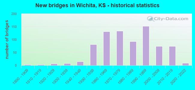
- New bridges - historical statistics
- 41900-1909
- 41910-1919
- 71920-1929
- 81930-1939
- 151940-1949
- 811950-1959
- 1311960-1969
- 1341970-1979
- 931980-1989
- 1521990-1999
- 742000-2009
- 742010-2019
- 92020-2022
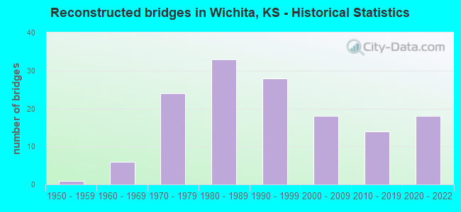
- Reconstructed bridges - Historical Statistics
- 11950-1959
- 61960-1969
- 241970-1979
- 331980-1989
- 281990-1999
- 182000-2009
- 142010-2019
- 182020-2022
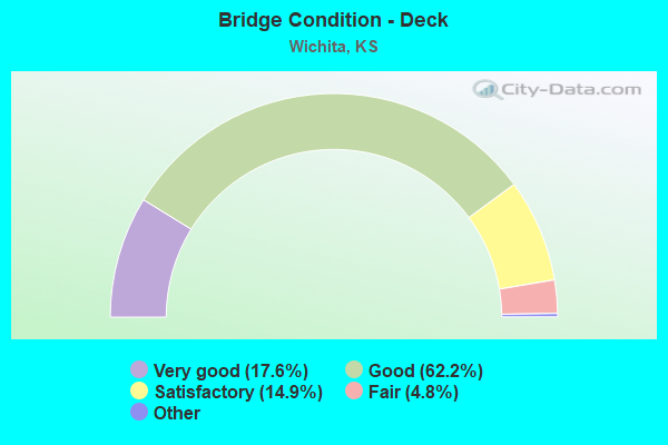
- Bridge Condition - Deck
- 17.6%Very good
- 62.2%Good
- 14.9%Satisfactory
- 4.8%Fair
- 0.5%Poor
- 0.2%Serious
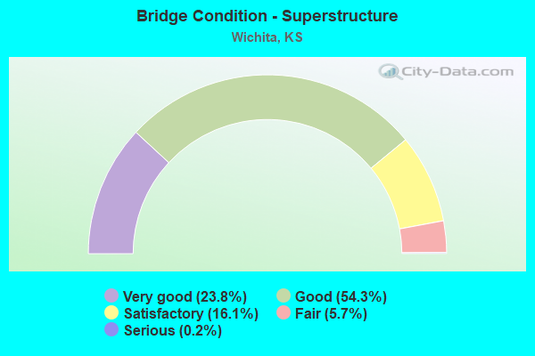
- Bridge Condition - Superstructure
- 23.8%Very good
- 54.3%Good
- 16.1%Satisfactory
- 5.7%Fair
- 0.2%Serious
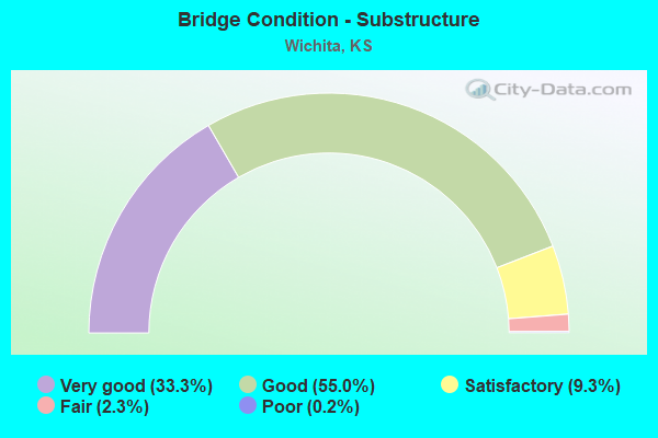
- Bridge Condition - Substructure
- 33.3%Very good
- 55.0%Good
- 9.3%Satisfactory
- 2.3%Fair
- 0.2%Poor
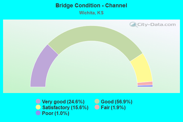
- Bridge Condition - Channel
- 24.6%Very good
- 56.9%Good
- 15.6%Satisfactory
- 1.9%Fair
- 1.0%Poor
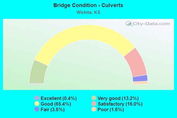
- Bridge Condition - Culverts
- 0.4%Excellent
- 13.2%Very good
- 65.4%Good
- 16.0%Satisfactory
- 3.5%Fair
- 1.6%Poor
Find on map >> Show street view
Structure Number: 999913500872991, Location: JCT I35W-US54 KELLOGG AVE (Lat: 37.678611, Lng: -97.311389), Route carried "on" structure: Ramp State highway 38, Year Built: 1977, Status: Open, Structure Length: 50.59m (165.98ft), Average Daily Traffic: 18,375 (year 2020), Truck Traffic: 5%, Average Future Daily Traffic: 71,448 (year 2041), Design Load: HS 20, Features Intersected: US 54-I135, 3 RAMPS, Facility Carried by Structure: RP I135 NB/U54 WB
Minimum Vertical Clearance: 30.47m (99.97ft), Kilometerpoint: 0.457, Lanes on structure: 1, Lanes under structure: 16, Owner: State Highway Agency, Approaching Roadway Width: 7.3m (24.0ft), Material/Design: Steel continuous, Design/Construction: Stringer/Multi-beam, Number Of Spans In Main Unit: 20, Length of Maximum Span: 37.6m (123.4ft), Curb-To-Curb Width: 7.3m (24.0ft), Out-to-Out Width: 8.2m (26.9ft)
Condition: Deck: Satisfactory, Superstructure: Good, Substructure: Very good, Channel: Very good, Operating Rating: 53.9 metric tons, Method Used To Determine Operating Rating: Load Factor (LF), Inventory Rating: 32.3 metric tons, Method Used To Determine Inventory Rating: Load Factor (LF), Structural Evaluation: Better than present minimum criteria, Deck Geometry: Better than present minimum criteria, Underclear: High priority of corrective action, Waterway Adequacy: Equal to present desirable criteria, Approach Roadway Alignment: Somewhat better than minimum adequacy, Length Of Structure Improvement: 165.98m (544.55ft), Designated Inspection Frequency: Every 24 months, Inspection Date: September 2020, Deck Structure Type: Concrete Cast-file-Place, Wearing Surface/Protective System: Wearing Surface: Epoxy Overlay
Find on map >> Show street view
Structure Number: 999913500873041, Location: JCT I35-US54 (Lat: 37.676111, Lng: -97.312500), Route carried "on" structure: Ramp State highway 38, Year Built: 1976, Status: Open, Structure Length: 13.55m (44.46ft), Average Daily Traffic: 15,025 (year 2020), Truck Traffic: 5%, Average Future Daily Traffic: 43,920 (year 2041), Design Load: HS 20, Features Intersected: I135 E&W LANES, Facility Carried by Structure: RP U54 EB/I135 NB
Minimum Vertical Clearance: 30.47m (99.97ft), Kilometerpoint: 0.224, Lanes on structure: 1, Lanes under structure: 6, Owner: State Highway Agency, Approaching Roadway Width: 9.1m (29.9ft), Material/Design: Concrete continuous, Design/Construction: Box Beam or Girders - Multiple, Number Of Spans In Main Unit: 7, Length of Maximum Span: 29.9m (98.1ft), Curb-To-Curb Width: 9.1m (29.9ft), Out-to-Out Width: 9.9m (32.5ft)
Condition: Deck: Satisfactory, Superstructure: Good, Substructure: Very good, Channel: Very good, Operating Rating: 61.1 metric tons, Method Used To Determine Operating Rating: Load Factor (LF), Inventory Rating: 36.6 metric tons, Method Used To Determine Inventory Rating: Load Factor (LF), Structural Evaluation: Better than present minimum criteria, Deck Geometry: Superior to present desirable criteria, Underclear: Somewhat better than minimum adequacy, Waterway Adequacy: Equal to present desirable criteria, Approach Roadway Alignment: Somewhat better than minimum adequacy, Length Of Structure Improvement: 44.45m (145.83ft), Designated Inspection Frequency: Every 24 months, Inspection Date: September 2020, Deck Structure Type: Concrete Cast-file-Place, Wearing Surface/Protective System: Wearing Surface: Epoxy Overlay
Find on map >> Show street view
Structure Number: 999913500873051, Location: JCT I35W-US54 (Lat: 37.677500, Lng: -97.312500), Route carried "on" structure: Ramp State highway 38, Year Built: 1976, Status: Open, Structure Length: 28.85m (94.65ft), Average Daily Traffic: 9,540 (year 2020), Truck Traffic: 5%, Average Future Daily Traffic: 43,920 (year 2041), Design Load: HS 20, Features Intersected: I135 NB/SB LANES & CANAL, Facility Carried by Structure: RP I135 SB/U54 EB
Minimum Vertical Clearance: 30.47m (99.97ft), Kilometerpoint: 0.859, Lanes on structure: 1, Lanes under structure: 6, Owner: State Highway Agency, Approaching Roadway Width: 9.1m (29.9ft), Material/Design: Concrete continuous, Design/Construction: Box Beam or Girders - Multiple, Number Of Spans In Main Unit: 13, Length of Maximum Span: 37.2m (122.0ft), Curb-To-Curb Width: 9.1m (29.9ft), Out-to-Out Width: 9.9m (32.5ft)
Condition: Deck: Satisfactory, Superstructure: Satisfactory, Substructure: Good, Channel: Very good, Operating Rating: 56.2 metric tons, Method Used To Determine Operating Rating: Load Factor (LF), Inventory Rating: 34.5 metric tons, Method Used To Determine Inventory Rating: Load Factor (LF), Structural Evaluation: Equal to present minimum criteria, Deck Geometry: Superior to present desirable criteria, Underclear: Equal to present minimum criteria, Waterway Adequacy: Equal to present desirable criteria, Approach Roadway Alignment: Better than present minimum criteria, Length Of Structure Improvement: 94.65m (310.53ft), Designated Inspection Frequency: Every 24 months, Inspection Date: September 2020, Deck Structure Type: Concrete Cast-file-Place, Wearing Surface/Protective System: Wearing Surface: Epoxy Overlay
Find on map >> Show street view
Structure Number: 999913500873061, Location: 0.02MI. N US 54 (Lat: 37.680000, Lng: -97.312500), Route carried "on" structure: Ramp State highway 38, Year Built: 1976, Status: Open, Structure Length: 14.10m (46.26ft), Average Daily Traffic: 7,430 (year 2020), Truck Traffic: 5%, Average Future Daily Traffic: 48,503 (year 2041), Design Load: HS 20, Features Intersected: I135 HWY EL&WL -CANAL, Facility Carried by Structure: RP U54 WB/I135 SB
Minimum Vertical Clearance: 30.47m (99.97ft), Kilometerpoint: 0.208, Lanes on structure: 1, Lanes under structure: 6, Owner: State Highway Agency, Approaching Roadway Width: 9.1m (29.9ft), Material/Design: Concrete continuous, Design/Construction: Box Beam or Girders - Multiple, Number Of Spans In Main Unit: 7, Length of Maximum Span: 32.6m (107.0ft), Curb-To-Curb Width: 9.1m (29.9ft), Out-to-Out Width: 9.9m (32.5ft)
Condition: Deck: Satisfactory, Superstructure: Good, Substructure: Very good, Channel: Very good, Operating Rating: 61.1 metric tons, Method Used To Determine Operating Rating: Load Factor (LF), Inventory Rating: 36.7 metric tons, Method Used To Determine Inventory Rating: Load Factor (LF), Structural Evaluation: Better than present minimum criteria, Deck Geometry: Superior to present desirable criteria, Underclear: Somewhat better than minimum adequacy, Waterway Adequacy: Equal to present desirable criteria, Approach Roadway Alignment: Somewhat better than minimum adequacy, Length Of Structure Improvement: 46.25m (151.74ft), Designated Inspection Frequency: Every 24 months, Inspection Date: September 2020, Deck Structure Type: Concrete Cast-file-Place, Wearing Surface/Protective System: Wearing Surface: Epoxy Overlay
Find on map >> Show street view
Structure Number: 999913500873071, Location: JCT MT VERNON & I35 (Lat: 37.656944, Lng: -97.312222), Route carried "on" structure: City street 6140, Year Built: 1976, Status: Open, Structure Length: 11.64m (38.19ft), Average Daily Traffic: 4,619 (year 2020), Truck Traffic: 5%, Average Future Daily Traffic: 3,778 (year 2041), Design Load: HS 20, Features Intersected: I135 HWY NB/SB -CANAL, Facility Carried by Structure: MT VERNON ST
Minimum Vertical Clearance: 30.47m (99.97ft), Kilometerpoint: 2.726, Lanes on structure: 4, Lanes under structure: 6, Owner: State Highway Agency, Approaching Roadway Width: 15.8m (51.8ft), Material/Design: Concrete continuous, Design/Construction: Box Beam or Girders - Multiple, Number Of Spans In Main Unit: 5, Length of Maximum Span: 32.5m (106.6ft), Curb or Sidewalk Widths: Left: 1.8m (5.9ft), Right: 1.8m (5.9ft), Curb-To-Curb Width: 15.8m (51.8ft), Out-to-Out Width: 19.6m (64.3ft)
Condition: Deck: Good, Superstructure: Good, Substructure: Good, Channel: Very good, Operating Rating: 74.1 metric tons, Method Used To Determine Operating Rating: Load Factor (LF), Inventory Rating: 44.4 metric tons, Method Used To Determine Inventory Rating: Load Factor (LF), Structural Evaluation: Better than present minimum criteria, Deck Geometry: Meets minimum limits, Underclear: Somewhat better than minimum adequacy, Waterway Adequacy: Equal to present desirable criteria, Approach Roadway Alignment: Meets minimum limits, Length Of Structure Improvement: 38.20m (125.33ft), Designated Inspection Frequency: Every 24 months, Inspection Date: September 2020, Deck Structure Type: Concrete Cast-file-Place, Wearing Surface/Protective System: Wearing Surface: Low Slump Concrete
Find on map >> Show street view
Structure Number: 999913500873101, Location: JCT. LINCOLN AVE & I35 (Lat: 37.671667, Lng: -97.312500), Route carried "on" structure: City street 6160, Year Built: 1976, Status: Open, Structure Length: 11.60m (38.06ft), Average Daily Traffic: 4,576 (year 2020), Truck Traffic: 5%, Average Future Daily Traffic: 3,743 (year 2041), Design Load: HS 20, Features Intersected: I135 HWY EL&WL -CANAL, Facility Carried by Structure: LINCOLN ST.
Minimum Vertical Clearance: 30.47m (99.97ft), Kilometerpoint: 6.915, Lanes on structure: 8, Lanes under structure: 8, Owner: State Highway Agency, Approaching Roadway Width: 23.8m (78.1ft), Skew: 20 degrees, Material/Design: Concrete continuous, Design/Construction: Box Beam or Girders - Multiple, Number Of Spans In Main Unit: 5, Length of Maximum Span: 29.9m (98.1ft), Curb or Sidewalk Widths: Left: 1.5m (4.9ft), Right: 0.0m, Curb-To-Curb Width: 23.8m (78.1ft), Out-to-Out Width: 28.0m (91.9ft)
Condition: Deck: Good, Superstructure: Good, Substructure: Good, Channel: Very good, Operating Rating: 66.8 metric tons, Method Used To Determine Operating Rating: Load Factor (LF), Inventory Rating: 40.0 metric tons, Method Used To Determine Inventory Rating: Load Factor (LF), Structural Evaluation: Better than present minimum criteria, Deck Geometry: High priority of replacement, Underclear: Somewhat better than minimum adequacy, Waterway Adequacy: Equal to present desirable criteria, Approach Roadway Alignment: Better than present minimum criteria, Length Of Structure Improvement: 38.05m (124.84ft), Designated Inspection Frequency: Every 24 months, Inspection Date: September 2020, Deck Structure Type: Concrete Cast-file-Place, Wearing Surface/Protective System: Wearing Surface: Low Slump Concrete
Find on map >> Show street view
Structure Number: 999913500873371, Location: 0.70 MI N OF K15 (Lat: 37.648889, Lng: -97.309444), Route carried "on" structure: Ramp State highway 35, Year Built: 1967, Status: Open, Structure Length: 9.83m (32.25ft), Average Daily Traffic: 3,340 (year 2020), Truck Traffic: 5%, Average Future Daily Traffic: 36,683 (year 2041), Design Load: HS 20, Features Intersected: HWY R/W ONLY
Minimum Vertical Clearance: 30.47m (99.97ft), Kilometerpoint: 0.332, Lanes on structure: 1, Owner: State Highway Agency, Approaching Roadway Width: 6.7m (22.0ft), Skew: 1 degrees, Material/Design: Concrete continuous, Design/Construction: Box Beam or Girders - Multiple, Number Of Spans In Main Unit: 4, Length of Maximum Span: 27.4m (89.9ft), Curb-To-Curb Width: 6.7m (22.0ft), Out-to-Out Width: 7.3m (24.0ft)
Condition: Deck: Good, Superstructure: Good, Substructure: Good, Operating Rating: 48.0 metric tons, Method Used To Determine Operating Rating: Load Factor (LF), Inventory Rating: 28.8 metric tons, Method Used To Determine Inventory Rating: Load Factor (LF), Structural Evaluation: Better than present minimum criteria, Deck Geometry: Equal to present minimum criteria, Approach Roadway Alignment: High priority of replacement, Length Of Structure Improvement: 32.25m (105.81ft), Designated Inspection Frequency: Every 24 months, Inspection Date: September 2020, Deck Structure Type: Concrete Cast-file-Place, Wearing Surface/Protective System: Wearing Surface: Epoxy Overlay
Find on map >> Show street view
Structure Number: 999913500873381, Location: 0.57 MI N US54 (Lat: 37.686944, Lng: -97.312778), Route carried "on" structure: Ramp State highway 39, Year Built: 1976, Year Reconstructed: 2020, Status: Open, Structure Length: 6.39m (20.96ft), Average Daily Traffic: 5,450 (year 2020), Truck Traffic: 5%, Average Future Daily Traffic: 58,386 (year 2041), Design Load: HS 20, Features Intersected: HWY R/W ONLY, Facility Carried by Structure: I135NB RMP-1ST ST
Minimum Vertical Clearance: 30.47m (99.97ft), Kilometerpoint: 0.111, Lanes on structure: 1, Owner: State Highway Agency, Approaching Roadway Width: 6.7m (22.0ft), Material/Design: Concrete continuous, Design/Construction: Box Beam or Girders - Multiple, Number Of Spans In Main Unit: 3, Length of Maximum Span: 24.4m (80.1ft), Curb-To-Curb Width: 6.7m (22.0ft), Out-to-Out Width: 7.3m (24.0ft)
Condition: Deck: Good, Superstructure: Good, Substructure: Very good, Operating Rating: 85.3 metric tons, Method Used To Determine Operating Rating: Load Factor (LF), Inventory Rating: 56.2 metric tons, Method Used To Determine Inventory Rating: Load Factor (LF), Structural Evaluation: Better than present minimum criteria, Deck Geometry: Equal to present minimum criteria, Approach Roadway Alignment: Somewhat better than minimum adequacy, Length Of Structure Improvement: 20.95m (68.73ft), Designated Inspection Frequency: Every 24 months, Inspection Date: September 2020, Deck Structure Type: Concrete Cast-file-Place, Wearing Surface/Protective System: Wearing Surface: Epoxy Overlay
Find on map >> Show street view
Structure Number: 999913500873391, Location: 0.58 MI N US54 (Lat: 37.686667, Lng: -97.313611), Route carried "on" structure: Ramp State highway 39, Year Built: 1976, Year Reconstructed: 2020, Status: Open, Structure Length: 6.39m (20.96ft), Average Daily Traffic: 5,110 (year 2020), Truck Traffic: 5%, Average Future Daily Traffic: 57,227 (year 2041), Design Load: HS 20, Features Intersected: HWY R/W ONLY, Facility Carried by Structure: 1ST RMP TO SB I135
Minimum Vertical Clearance: 30.47m (99.97ft), Kilometerpoint: 0.146, Lanes on structure: 1, Owner: State Highway Agency, Approaching Roadway Width: 6.7m (22.0ft), Material/Design: Concrete continuous, Design/Construction: Box Beam or Girders - Multiple, Number Of Spans In Main Unit: 3, Length of Maximum Span: 24.4m (80.1ft), Curb-To-Curb Width: 6.7m (22.0ft), Out-to-Out Width: 7.3m (24.0ft)
Condition: Deck: Good, Superstructure: Good, Substructure: Very good, Operating Rating: 89.8 metric tons, Method Used To Determine Operating Rating: Load Factor (LF), Inventory Rating: 60.8 metric tons, Method Used To Determine Inventory Rating: Load Factor (LF), Structural Evaluation: Better than present minimum criteria, Deck Geometry: Equal to present minimum criteria, Approach Roadway Alignment: Somewhat better than minimum adequacy, Length Of Structure Improvement: 20.95m (68.73ft), Designated Inspection Frequency: Every 24 months, Inspection Date: September 2020, Deck Structure Type: Concrete Cast-file-Place, Wearing Surface/Protective System: Wearing Surface: Epoxy Overlay
Find on map >> Show street view
Structure Number: 999913500873401, Location: 0.88 MI N OF US54 (Lat: 37.691111, Lng: -97.313889), Route carried "on" structure: Ramp State highway 39, Year Built: 1976, Year Reconstructed: 2020, Status: Open, Structure Length: 6.39m (20.96ft), Average Daily Traffic: 5,185 (year 2020), Truck Traffic: 5%, Average Future Daily Traffic: 57,227 (year 2041), Design Load: HS 20, Features Intersected: HWY R/W ONLY, Facility Carried by Structure: 2NDST RMP-NBNDI135
Minimum Vertical Clearance: 30.47m (99.97ft), Kilometerpoint: 0.142, Lanes on structure: 1, Owner: State Highway Agency, Approaching Roadway Width: 6.7m (22.0ft), Material/Design: Concrete continuous, Design/Construction: Box Beam or Girders - Multiple, Number Of Spans In Main Unit: 3, Length of Maximum Span: 24.4m (80.1ft), Curb-To-Curb Width: 6.7m (22.0ft), Out-to-Out Width: 7.3m (24.0ft)
Condition: Deck: Good, Superstructure: Good, Substructure: Very good, Operating Rating: 85.3 metric tons, Method Used To Determine Operating Rating: Load Factor (LF), Inventory Rating: 56.2 metric tons, Method Used To Determine Inventory Rating: Load Factor (LF), Structural Evaluation: Better than present minimum criteria, Deck Geometry: Equal to present minimum criteria, Approach Roadway Alignment: Somewhat better than minimum adequacy, Length Of Structure Improvement: 20.95m (68.73ft), Designated Inspection Frequency: Every 24 months, Inspection Date: September 2020, Deck Structure Type: Concrete Cast-file-Place, Wearing Surface/Protective System: Wearing Surface: Epoxy Overlay
Find on map >> Show street view
Structure Number: 999913500873411, Location: 0.89 N OF US54 HWY (Lat: 37.691111, Lng: -97.315000), Route carried "on" structure: Ramp State highway 39, Year Built: 1976, Year Reconstructed: 2020, Status: Open, Structure Length: 6.39m (20.96ft), Average Daily Traffic: 5,185 (year 2020), Truck Traffic: 5%, Average Future Daily Traffic: 57,227 (year 2041), Design Load: HS 20, Features Intersected: HWY R/W ONLY, Facility Carried by Structure: SBN I135 TO 2ND ST
Minimum Vertical Clearance: 30.47m (99.97ft), Kilometerpoint: 0.058, Lanes on structure: 1, Owner: State Highway Agency, Approaching Roadway Width: 6.7m (22.0ft), Material/Design: Concrete continuous, Design/Construction: Box Beam or Girders - Multiple, Number Of Spans In Main Unit: 3, Length of Maximum Span: 24.4m (80.1ft), Curb-To-Curb Width: 6.7m (22.0ft), Out-to-Out Width: 7.3m (24.0ft)
Condition: Deck: Very good, Superstructure: Good, Substructure: Very good, Operating Rating: 89.8 metric tons, Method Used To Determine Operating Rating: Load Factor (LF), Inventory Rating: 59.9 metric tons, Method Used To Determine Inventory Rating: Load Factor (LF), Structural Evaluation: Better than present minimum criteria, Deck Geometry: Equal to present minimum criteria, Approach Roadway Alignment: Somewhat better than minimum adequacy, Length Of Structure Improvement: 20.95m (68.73ft), Designated Inspection Frequency: Every 24 months, Inspection Date: September 2020, Deck Structure Type: Concrete Cast-file-Place, Wearing Surface/Protective System: Wearing Surface: Epoxy Overlay
Find on map >> Show street view
Structure Number: 999913500873421, Location: 1.15 MI N OF US54 (Lat: 37.695000, Lng: -97.315278), Route carried "on" structure: Ramp State highway 40, Year Built: 1976, Year Reconstructed: 2020, Status: Open, Structure Length: 11.26m (36.94ft), Average Daily Traffic: 4,460 (year 2020), Truck Traffic: 5%, Average Future Daily Traffic: 57,227 (year 2041), Design Load: HS 20, Features Intersected: HWY R/W ONLY, Facility Carried by Structure: CNTRL RP TONBI135
Minimum Vertical Clearance: 30.47m (99.97ft), Kilometerpoint: 0.203, Lanes on structure: 2, Owner: State Highway Agency, Approaching Roadway Width: 8.5m (27.9ft), Material/Design: Concrete continuous, Design/Construction: Box Beam or Girders - Multiple, Number Of Spans In Main Unit: 5, Length of Maximum Span: 24.4m (80.1ft), Curb-To-Curb Width: 7.5m (24.6ft), Out-to-Out Width: 8.3m (27.2ft)
Condition: Deck: Good, Superstructure: Good, Substructure: Very good, Operating Rating: 77.1 metric tons, Method Used To Determine Operating Rating: Load Factor (LF), Inventory Rating: 46.3 metric tons, Method Used To Determine Inventory Rating: Load Factor (LF), Structural Evaluation: Better than present minimum criteria, Deck Geometry: High priority of replacement, Approach Roadway Alignment: Somewhat better than minimum adequacy, Length Of Structure Improvement: 36.95m (121.23ft), Designated Inspection Frequency: Every 24 months, Inspection Date: September 2020, Deck Structure Type: Concrete Cast-file-Place, Wearing Surface/Protective System: Wearing Surface: Epoxy Overlay
Find on map >> Show street view
Structure Number: 999913500873431, Location: 1.17 MI N OF US54 (Lat: 37.694722, Lng: -97.316389), Route carried "on" structure: Ramp State highway 40, Year Built: 1976, Year Reconstructed: 2020, Status: Open, Structure Length: 8.82m (28.94ft), Average Daily Traffic: 4,525 (year 2020), Truck Traffic: 5%, Average Future Daily Traffic: 57,227 (year 2041), Design Load: HS 20, Features Intersected: HWY R/W ONLY, Facility Carried by Structure: SB RMP-135-CNTRL
Minimum Vertical Clearance: 30.47m (99.97ft), Kilometerpoint: 0.158, Lanes on structure: 1, Owner: State Highway Agency, Approaching Roadway Width: 6.7m (22.0ft), Material/Design: Concrete continuous, Design/Construction: Box Beam or Girders - Multiple, Number Of Spans In Main Unit: 4, Length of Maximum Span: 24.4m (80.1ft), Curb-To-Curb Width: 6.7m (22.0ft), Out-to-Out Width: 7.3m (24.0ft)
Condition: Deck: Good, Superstructure: Satisfactory, Substructure: Very good, Operating Rating: 89.8 metric tons, Method Used To Determine Operating Rating: Load Factor (LF), Inventory Rating: 52.6 metric tons, Method Used To Determine Inventory Rating: Load Factor (LF), Structural Evaluation: Equal to present minimum criteria, Deck Geometry: Equal to present minimum criteria, Approach Roadway Alignment: Somewhat better than minimum adequacy, Length Of Structure Improvement: 28.95m (94.98ft), Designated Inspection Frequency: Every 24 months, Inspection Date: September 2020, Deck Structure Type: Concrete Cast-file-Place, Wearing Surface/Protective System: Wearing Surface: Epoxy Overlay
Find on map >> Show street view
Structure Number: 999913500873441, Location: 1.38 MI N OF US54 (Lat: 37.698056, Lng: -97.316111), Route carried "on" structure: Ramp State highway 74, Year Built: 1976, Year Reconstructed: 2020, Status: Open, Structure Length: 6.39m (20.96ft), Average Daily Traffic: 5,780 (year 2020), Truck Traffic: 5%, Average Future Daily Traffic: 56,739 (year 2041), Design Load: HS 20, Features Intersected: HWY R/W ONLY, Facility Carried by Structure: NB I135 RMP-9TH ST
Minimum Vertical Clearance: 30.47m (99.97ft), Kilometerpoint: 0.069, Lanes on structure: 1, Owner: State Highway Agency, Approaching Roadway Width: 6.7m (22.0ft), Material/Design: Concrete continuous, Design/Construction: Box Beam or Girders - Multiple, Number Of Spans In Main Unit: 3, Length of Maximum Span: 24.4m (80.1ft), Curb-To-Curb Width: 6.7m (22.0ft), Out-to-Out Width: 7.3m (24.0ft)
Condition: Deck: Good, Superstructure: Good, Substructure: Good, Operating Rating: 85.3 metric tons, Method Used To Determine Operating Rating: Load Factor (LF), Inventory Rating: 59.0 metric tons, Method Used To Determine Inventory Rating: Load Factor (LF), Structural Evaluation: Better than present minimum criteria, Deck Geometry: Equal to present minimum criteria, Approach Roadway Alignment: Somewhat better than minimum adequacy, Length Of Structure Improvement: 20.95m (68.73ft), Designated Inspection Frequency: Every 24 months, Inspection Date: September 2020, Deck Structure Type: Concrete Cast-file-Place, Wearing Surface/Protective System: Wearing Surface: Epoxy Overlay
Find on map >> Show street view
Structure Number: 999913500873451, Location: 1.42 MI.N OF US54 (Lat: 37.698333, Lng: -97.317500), Route carried "on" structure: Ramp State highway 74, Year Built: 1976, Year Reconstructed: 2020, Status: Open, Structure Length: 6.39m (20.96ft), Average Daily Traffic: 5,365 (year 2020), Truck Traffic: 5%, Average Future Daily Traffic: 56,739 (year 2041), Design Load: HS 20, Features Intersected: HWY R/W ONLY, Facility Carried by Structure: 8TH RMP TO SBI135
Minimum Vertical Clearance: 30.47m (99.97ft), Kilometerpoint: 0.185, Lanes on structure: 1, Owner: State Highway Agency, Approaching Roadway Width: 8.5m (27.9ft), Material/Design: Concrete continuous, Design/Construction: Box Beam or Girders - Multiple, Number Of Spans In Main Unit: 3, Length of Maximum Span: 24.4m (80.1ft), Curb-To-Curb Width: 6.7m (22.0ft), Out-to-Out Width: 7.3m (24.0ft)
Condition: Deck: Good, Superstructure: Satisfactory, Substructure: Very good, Operating Rating: 89.8 metric tons, Method Used To Determine Operating Rating: Load Factor (LF), Inventory Rating: 66.2 metric tons, Method Used To Determine Inventory Rating: Load Factor (LF), Structural Evaluation: Equal to present minimum criteria, Deck Geometry: Equal to present minimum criteria, Approach Roadway Alignment: Somewhat better than minimum adequacy, Length Of Structure Improvement: 20.95m (68.73ft), Designated Inspection Frequency: Every 24 months, Inspection Date: September 2020, Deck Structure Type: Concrete Cast-file-Place, Wearing Surface/Protective System: Wearing Surface: Epoxy Overlay
Find on map >> Show street view
Structure Number: 999913500873461, Location: 1.65 MI N OF US54 (Lat: 37.701944, Lng: -97.317500), Route carried "on" structure: Ramp State highway 74, Year Built: 1976, Year Reconstructed: 2020, Status: Open, Structure Length: 6.39m (20.96ft), Average Daily Traffic: 3,245 (year 2020), Truck Traffic: 5%, Average Future Daily Traffic: 56,739 (year 2041), Design Load: HS 20, Features Intersected: HWY R/W ONLY, Facility Carried by Structure: 9THST RMP-NB I135
Minimum Vertical Clearance: 30.47m (99.97ft), Kilometerpoint: 0.203, Lanes on structure: 1, Owner: State Highway Agency, Approaching Roadway Width: 7.9m (25.9ft), Material/Design: Concrete continuous, Design/Construction: Box Beam or Girders - Multiple, Number Of Spans In Main Unit: 3, Length of Maximum Span: 24.4m (80.1ft), Curb-To-Curb Width: 6.7m (22.0ft), Out-to-Out Width: 7.3m (24.0ft)
Condition: Deck: Good, Superstructure: Good, Substructure: Very good, Operating Rating: 85.3 metric tons, Method Used To Determine Operating Rating: Load Factor (LF), Inventory Rating: 53.5 metric tons, Method Used To Determine Inventory Rating: Load Factor (LF), Structural Evaluation: Better than present minimum criteria, Deck Geometry: Equal to present minimum criteria, Approach Roadway Alignment: Somewhat better than minimum adequacy, Length Of Structure Improvement: 20.95m (68.73ft), Designated Inspection Frequency: Every 24 months, Inspection Date: September 2020, Deck Structure Type: Concrete Cast-file-Place, Wearing Surface/Protective System: Wearing Surface: Epoxy Overlay
Find on map >> Show street view
Structure Number: 999913500873471, Location: 2.20 MI N OF US54 (Lat: 37.701944, Lng: -97.318611), Route carried "on" structure: Ramp State highway 74, Year Built: 1976, Year Reconstructed: 2020, Status: Open, Structure Length: 6.39m (20.96ft), Average Daily Traffic: 3,350 (year 2020), Truck Traffic: 5%, Average Future Daily Traffic: 56,739 (year 2041), Design Load: HS 20, Features Intersected: HWY R/W ONLY, Facility Carried by Structure: SB I135 RMP-9TH ST
Minimum Vertical Clearance: 30.47m (99.97ft), Kilometerpoint: 0.140, Lanes on structure: 1, Owner: State Highway Agency, Approaching Roadway Width: 6.7m (22.0ft), Material/Design: Concrete continuous, Design/Construction: Box Beam or Girders - Multiple, Number Of Spans In Main Unit: 3, Length of Maximum Span: 24.4m (80.1ft), Curb-To-Curb Width: 6.7m (22.0ft), Out-to-Out Width: 7.3m (24.0ft)
Condition: Deck: Good, Superstructure: Good, Substructure: Very good, Operating Rating: 89.8 metric tons, Method Used To Determine Operating Rating: Load Factor (LF), Inventory Rating: 56.3 metric tons, Method Used To Determine Inventory Rating: Load Factor (LF), Structural Evaluation: Better than present minimum criteria, Deck Geometry: Equal to present minimum criteria, Approach Roadway Alignment: Somewhat better than minimum adequacy, Length Of Structure Improvement: 20.95m (68.73ft), Designated Inspection Frequency: Every 24 months, Inspection Date: September 2020, Deck Structure Type: Concrete Cast-file-Place, Wearing Surface/Protective System: Wearing Surface: Epoxy Overlay
Find on map >> Show street view
Structure Number: 999913500873481, Location: 1.98 MI N OF US54 (Lat: 37.706389, Lng: -97.318889), Route carried "on" structure: Ramp State highway 41, Year Built: 1976, Year Reconstructed: 2020, Status: Open, Structure Length: 6.39m (20.96ft), Average Daily Traffic: 8,525 (year 2020), Truck Traffic: 5%, Average Future Daily Traffic: 52,346 (year 2041), Design Load: HS 20, Features Intersected: HWY R/W ONLY, Facility Carried by Structure: NB I135 RMP-13TH
Minimum Vertical Clearance: 30.47m (99.97ft), Kilometerpoint: 0.174, Lanes on structure: 1, Owner: State Highway Agency, Approaching Roadway Width: 6.7m (22.0ft), Material/Design: Concrete continuous, Design/Construction: Box Beam or Girders - Multiple, Number Of Spans In Main Unit: 3, Length of Maximum Span: 24.4m (80.1ft), Curb-To-Curb Width: 6.7m (22.0ft), Out-to-Out Width: 7.3m (24.0ft)
Condition: Deck: Good, Superstructure: Good, Substructure: Very good, Operating Rating: 89.8 metric tons, Method Used To Determine Operating Rating: Load Factor (LF), Inventory Rating: 54.4 metric tons, Method Used To Determine Inventory Rating: Load Factor (LF), Structural Evaluation: Better than present minimum criteria, Deck Geometry: Equal to present minimum criteria, Approach Roadway Alignment: Somewhat better than minimum adequacy, Length Of Structure Improvement: 20.95m (68.73ft), Designated Inspection Frequency: Every 24 months, Inspection Date: September 2020, Deck Structure Type: Concrete Cast-file-Place, Wearing Surface/Protective System: Wearing Surface: Epoxy Overlay
Find on map >> Show street view
Structure Number: 999913500873491, Location: 1.99 MI N OF US54 (Lat: 37.706389, Lng: -97.320000), Route carried "on" structure: Ramp State highway 41, Year Built: 1976, Year Reconstructed: 2020, Status: Open, Structure Length: 6.39m (20.96ft), Average Daily Traffic: 8,530 (year 2020), Truck Traffic: 5%, Average Future Daily Traffic: 52,346 (year 2041), Design Load: HS 20, Features Intersected: HWY R/W ONLY, Facility Carried by Structure: 13TH RMP-SB I135
Minimum Vertical Clearance: 30.47m (99.97ft), Kilometerpoint: 0.158, Lanes on structure: 1, Owner: State Highway Agency, Approaching Roadway Width: 8.5m (27.9ft), Material/Design: Concrete continuous, Design/Construction: Box Beam or Girders - Multiple, Number Of Spans In Main Unit: 3, Length of Maximum Span: 24.4m (80.1ft), Curb-To-Curb Width: 7.5m (24.6ft), Out-to-Out Width: 8.3m (27.2ft)
Condition: Deck: Good, Superstructure: Good, Substructure: Very good, Operating Rating: 71.7 metric tons, Method Used To Determine Operating Rating: Load Factor (LF), Inventory Rating: 42.6 metric tons, Method Used To Determine Inventory Rating: Load Factor (LF), Structural Evaluation: Better than present minimum criteria, Deck Geometry: Better than present minimum criteria, Approach Roadway Alignment: Somewhat better than minimum adequacy, Length Of Structure Improvement: 20.95m (68.73ft), Designated Inspection Frequency: Every 24 months, Inspection Date: September 2020, Deck Structure Type: Concrete Cast-file-Place, Wearing Surface/Protective System: Wearing Surface: Epoxy Overlay
Find on map >> Show street view
Structure Number: 999913500873501, Location: 2.18 MI N OF US54 (Lat: 37.709167, Lng: -97.319722), Route carried "on" structure: Ramp State highway 41, Year Built: 1976, Year Reconstructed: 2020, Status: Open, Structure Length: 6.39m (20.96ft), Average Daily Traffic: 4,080 (year 2020), Truck Traffic: 5%, Average Future Daily Traffic: 52,346 (year 2041), Design Load: HS 20, Features Intersected: HWY R/W ONLY, Facility Carried by Structure: 13ST RMP-NBND I135
Minimum Vertical Clearance: 30.47m (99.97ft), Kilometerpoint: 0.146, Lanes on structure: 1, Owner: State Highway Agency, Approaching Roadway Width: 9.1m (29.9ft), Material/Design: Concrete continuous, Design/Construction: Box Beam or Girders - Multiple, Number Of Spans In Main Unit: 3, Length of Maximum Span: 24.4m (80.1ft), Curb-To-Curb Width: 9.1m (29.9ft), Out-to-Out Width: 9.8m (32.2ft)
Condition: Deck: Good, Superstructure: Good, Substructure: Good, Operating Rating: 77.7 metric tons, Method Used To Determine Operating Rating: Load Factor (LF), Inventory Rating: 46.4 metric tons, Method Used To Determine Inventory Rating: Load Factor (LF), Structural Evaluation: Better than present minimum criteria, Deck Geometry: Superior to present desirable criteria, Approach Roadway Alignment: Somewhat better than minimum adequacy, Length Of Structure Improvement: 20.95m (68.73ft), Designated Inspection Frequency: Every 24 months, Inspection Date: September 2020, Deck Structure Type: Concrete Cast-file-Place, Wearing Surface/Protective System: Wearing Surface: Epoxy Overlay
Find on map >> Show street view
Structure Number: 999913500873511, Location: 1.66 MI N OF US54 (Lat: 37.709444, Lng: -97.320833), Route carried "on" structure: Ramp State highway 41, Year Built: 1976, Year Reconstructed: 2020, Status: Open, Structure Length: 6.39m (20.96ft), Average Daily Traffic: 4,170 (year 2020), Truck Traffic: 5%, Average Future Daily Traffic: 52,346 (year 2041), Design Load: HS 20, Features Intersected: HWY R/W ONLY, Facility Carried by Structure: I135 SBND RMP-13TH
Minimum Vertical Clearance: 30.47m (99.97ft), Kilometerpoint: 0.248, Lanes on structure: 1, Owner: State Highway Agency, Approaching Roadway Width: 6.7m (22.0ft), Material/Design: Concrete continuous, Design/Construction: Box Beam or Girders - Multiple, Number Of Spans In Main Unit: 3, Length of Maximum Span: 24.4m (80.1ft), Curb-To-Curb Width: 6.7m (22.0ft), Out-to-Out Width: 7.3m (24.0ft)
Condition: Deck: Good, Superstructure: Good, Substructure: Very good, Operating Rating: 89.8 metric tons, Method Used To Determine Operating Rating: Load Factor (LF), Inventory Rating: 60.8 metric tons, Method Used To Determine Inventory Rating: Load Factor (LF), Structural Evaluation: Better than present minimum criteria, Deck Geometry: Equal to present minimum criteria, Approach Roadway Alignment: Somewhat better than minimum adequacy, Length Of Structure Improvement: 20.95m (68.73ft), Designated Inspection Frequency: Every 24 months, Inspection Date: September 2020, Deck Structure Type: Concrete Cast-file-Place, Wearing Surface/Protective System: Wearing Surface: Epoxy Overlay
Find on map >> Show street view
Structure Number: 999913500874671, Location: .08 MI N 21ST STREET (Lat: 37.722500, Lng: -97.318056), Route carried "on" structure: Interstate 135, Year Built: 2002, Status: Open, Structure Length: 5.58m (18.31ft), Average Daily Traffic: 34,764 (year 2020), Truck Traffic: 9%, Average Future Daily Traffic: 42,419 (year 2041), Design Load: HS 25 or greater, Features Intersected: 21ST ST
Minimum Vertical Clearance: 30.47m (99.97ft), Kilometerpoint: 15.092, Lanes on structure: 3, Lanes under structure: 5, Base Highway Network: Yes, Owner: State Highway Agency, Approaching Roadway Width: 17.1m (56.1ft), Material/Design: Concrete continuous, Design/Construction: Slab, Number Of Spans In Main Unit: 3, Length of Maximum Span: 22.0m (72.2ft), Curb-To-Curb Width: 17.1m (56.1ft), Out-to-Out Width: 17.9m (58.7ft)
Condition: Deck: Good, Superstructure: Good, Substructure: Very good, Operating Rating: 90.6 metric tons, Method Used To Determine Operating Rating: Load Factor (LF), Inventory Rating: 54.4 metric tons, Method Used To Determine Inventory Rating: Load Factor (LF), Structural Evaluation: Better than present minimum criteria, Deck Geometry: Equal to present minimum criteria, Underclear: High priority of corrective action, Approach Roadway Alignment: Equal to present desirable criteria, Length Of Structure Improvement: 18.30m (60.04ft), Designated Inspection Frequency: Every 24 months, Inspection Date: September 2020, Wearing Surface/Protective System: Wearing Surface: Monolithic Concrete, Deck Protection: Epoxy Coated Reinforcing
Find on map >> Show street view
Structure Number: 999913500874681, Location: .09 MI N 21ST STREET (Lat: 37.722500, Lng: -97.317778), Route carried "on" structure: Interstate 135, Year Built: 2002, Status: Open, Structure Length: 5.58m (18.31ft), Average Daily Traffic: 34,764 (year 2020), Truck Traffic: 9%, Average Future Daily Traffic: 42,419 (year 2041), Design Load: HS 25 or greater, Features Intersected: 21st Street
Minimum Vertical Clearance: 30.47m (99.97ft), Kilometerpoint: 15.377, Lanes on structure: 3, Lanes under structure: 5, Base Highway Network: Yes, Owner: State Highway Agency, Approaching Roadway Width: 17.1m (56.1ft), Material/Design: Concrete continuous, Design/Construction: Slab, Number Of Spans In Main Unit: 3, Length of Maximum Span: 22.0m (72.2ft), Curb-To-Curb Width: 17.1m (56.1ft), Out-to-Out Width: 17.9m (58.7ft)
Condition: Deck: Good, Superstructure: Good, Substructure: Very good, Operating Rating: 90.6 metric tons, Method Used To Determine Operating Rating: Load Factor (LF), Inventory Rating: 54.4 metric tons, Method Used To Determine Inventory Rating: Load Factor (LF), Structural Evaluation: Better than present minimum criteria, Deck Geometry: Equal to present minimum criteria, Underclear: High priority of corrective action, Approach Roadway Alignment: Equal to present desirable criteria, Length Of Structure Improvement: 18.30m (60.04ft), Designated Inspection Frequency: Every 24 months, Inspection Date: September 2020, Wearing Surface/Protective System: Wearing Surface: Monolithic Concrete, Deck Protection: Epoxy Coated Reinforcing
Find on map >> Show street view
Structure Number: 999923200270551, Location: 1.25 MI S I70 (Lat: 38.830556, Lng: -98.467500), Route carried "on" structure: State highway 232, Year Built: 1962, Status: Open, Structure Length: 1.14m (3.74ft), Average Daily Traffic: 800 (year 2020), Truck Traffic: 13%, Average Future Daily Traffic: 938 (year 2041), Design Load: H 20, Features Intersected: WILSON CREEK
Minimum Vertical Clearance: 30.47m (99.97ft), Kilometerpoint: 0.811, Lanes on structure: 2, Owner: State Highway Agency, Approaching Roadway Width: 7.3m (24.0ft), Material/Design: Concrete, Design/Construction: Culvert, Number Of Spans In Main Unit: 3, Length of Maximum Span: 3.7m (12.1ft), Curb-To-Curb Width: 13.4m (44.0ft), Out-to-Out Width: 13.9m (45.6ft)
Condition: Channel: Very good, Culverts: Poor, Operating Rating: 35.4 metric tons, Method Used To Determine Operating Rating: Load Factor (LF), Inventory Rating: 20.9 metric tons, Method Used To Determine Inventory Rating: Load Factor (LF), Structural Evaluation: Meets minimum limits, Deck Geometry: Superior to present desirable criteria, Waterway Adequacy: Better than present minimum criteria, Approach Roadway Alignment: Somewhat better than minimum adequacy, Length Of Structure Improvement: 3.75m (12.30ft), Designated Inspection Frequency: Every 12 months, Inspection Date: October 2021, Deck Structure Type: Concrete Cast-file-Place, Wearing Surface/Protective System: Wearing Surface: Bituminous
Find on map >> Show street view
Structure Number: 999923500870321, Location: JCT I235/I135 (Lat: 37.759722, Lng: -97.322500), Route carried "on" structure: Interstate 235, Year Built: 1964, Year Reconstructed: 2021, Status: Open, Structure Length: 4.52m (14.83ft), Average Daily Traffic: 2,550 (year 2020), Truck Traffic: 10%, Average Future Daily Traffic: 4,261 (year 2041), Design Load: HS 20+Mod, Features Intersected: I135 HWY SB
Minimum Vertical Clearance: 30.47m (99.97ft), Kilometerpoint: 26.330, Lanes on structure: 1, Lanes under structure: 2, Base Highway Network: Yes, Owner: State Highway Agency, Approaching Roadway Width: 9.1m (29.9ft), Skew: 2 degrees, Material/Design: Concrete continuous, Design/Construction: Box Beam or Girders - Multiple, Number Of Spans In Main Unit: 3, Length of Maximum Span: 20.7m (67.9ft), Curb-To-Curb Width: 9.2m (30.2ft), Out-to-Out Width: 9.9m (32.5ft)
Condition: Deck: Satisfactory, Superstructure: Good, Substructure: Very good, Operating Rating: 86.5 metric tons, Method Used To Determine Operating Rating: Load Factor (LF), Inventory Rating: 51.8 metric tons, Method Used To Determine Inventory Rating: Load Factor (LF), Structural Evaluation: Better than present minimum criteria, Deck Geometry: Meets minimum limits, Underclear: Meets minimum limits, Approach Roadway Alignment: Somewhat better than minimum adequacy, Length Of Structure Improvement: 14.83m (48.65ft), Designated Inspection Frequency: Every 24 months, Inspection Date: December 2021, Deck Structure Type: Concrete Cast-file-Place, Wearing Surface/Protective System: Wearing Surface: Bituminous
Find on map >> Show street view
Structure Number: 999923500870341, Location: 0.06 MI N I235, SB (Lat: 37.761389, Lng: -97.323056), Route carried "on" structure: State highway 96, Year Built: 1964, Year Reconstructed: 2021, Status: Open, Structure Length: 3.71m (12.17ft), Average Daily Traffic: 23,040 (year 2020), Truck Traffic: 11%, Average Future Daily Traffic: 38,497 (year 2041), Design Load: HS 20+Mod, Features Intersected: I-135 HWY SB, Facility Carried by Structure: I235 HWY, SB
Minimum Vertical Clearance: 30.47m (99.97ft), Kilometerpoint: 39.073, Lanes on structure: 1, Lanes under structure: 2, Base Highway Network: Yes, Owner: State Highway Agency, Approaching Roadway Width: 9.1m (29.9ft), Skew: 1 degrees, Material/Design: Concrete continuous, Design/Construction: Slab, Number Of Spans In Main Unit: 3, Length of Maximum Span: 15.5m (50.9ft), Curb-To-Curb Width: 11.0m (36.1ft), Out-to-Out Width: 11.0m (36.1ft)
Condition: Deck: Satisfactory, Superstructure: Satisfactory, Substructure: Good, Operating Rating: 55.3 metric tons, Method Used To Determine Operating Rating: Load Factor (LF), Inventory Rating: 33.6 metric tons, Method Used To Determine Inventory Rating: Load Factor (LF), Structural Evaluation: Equal to present minimum criteria, Deck Geometry: Meets minimum limits, Underclear: High priority of corrective action, Approach Roadway Alignment: Better than present minimum criteria, Length Of Structure Improvement: 12.17m (39.93ft), Designated Inspection Frequency: Every 24 months, Inspection Date: September 2020, Deck Structure Type: Concrete Cast-file-Place, Wearing Surface/Protective System: Wearing Surface: Bituminous
Find on map >> Show street view
Structure Number: 999923500870621, Location: 0.34 MI W I135, SB (Lat: 37.616111, Lng: -97.330833), Route carried "on" structure: Ramp State highway 32, Year Built: 1965, Status: Open, Structure Length: 6.53m (21.42ft), Average Daily Traffic: 9,810 (year 2020), Truck Traffic: 5%, Average Future Daily Traffic: 30,165 (year 2041), Design Load: HS 20+Mod, Features Intersected: I235 HWY, NB, Facility Carried by Structure: I235 SB TO I135 NB
Minimum Vertical Clearance: 30.47m (99.97ft), Kilometerpoint: 0.172, Lanes on structure: 1, Lanes under structure: 2, Owner: State Highway Agency, Approaching Roadway Width: 9.1m (29.9ft), Skew: 5 degrees, Material/Design: Steel continuous, Design/Construction: Stringer/Multi-beam, Number Of Spans In Main Unit: 3, Length of Maximum Span: 25.3m (83.0ft), Curb-To-Curb Width: 9.1m (29.9ft), Out-to-Out Width: 9.8m (32.2ft)
Condition: Deck: Good, Superstructure: Good, Substructure: Satisfactory, Operating Rating: 44.5 metric tons, Method Used To Determine Operating Rating: Load Factor (LF), Inventory Rating: 26.3 metric tons, Method Used To Determine Inventory Rating: Load Factor (LF), Structural Evaluation: Equal to present minimum criteria, Deck Geometry: Superior to present desirable criteria, Underclear: Equal to present minimum criteria, Approach Roadway Alignment: Somewhat better than minimum adequacy, Length Of Structure Improvement: 21.41m (70.24ft), Designated Inspection Frequency: Every 24 months, Inspection Date: September 2020, Deck Structure Type: Concrete Cast-file-Place, Wearing Surface/Protective System: Wearing Surface: Epoxy Overlay
Find on map >> Show street view
Structure Number: 999923500870631, Location: JCT BROADWAY/I235, SB (Lat: 37.616667, Lng: -97.333889), Route carried "on" structure: Interstate 235, Year Built: 1961, Status: Open, Structure Length: 4.82m (15.81ft), Average Daily Traffic: 19,094 (year 2020), Truck Traffic: 8%, Average Future Daily Traffic: 28,373 (year 2041), Design Load: HS 20+Mod, Features Intersected: BROADWAY ST
Minimum Vertical Clearance: 30.47m (99.97ft), Kilometerpoint: 0.827, Lanes on structure: 2, Lanes under structure: 4, Base Highway Network: Yes, Owner: State Highway Agency, Approaching Roadway Width: 12.2m (40.0ft), Skew: 2 degrees, Material/Design: Steel continuous, Design/Construction: Stringer/Multi-beam, Number Of Spans In Main Unit: 3, Length of Maximum Span: 21.9m (71.9ft), Curb-To-Curb Width: 12.2m (40.0ft), Out-to-Out Width: 12.8m (42.0ft)
Condition: Deck: Good, Superstructure: Good, Substructure: Good, Operating Rating: 59.0 metric tons, Method Used To Determine Operating Rating: Load Factor (LF), Inventory Rating: 35.4 metric tons, Method Used To Determine Inventory Rating: Load Factor (LF), Structural Evaluation: Better than present minimum criteria, Deck Geometry: Better than present minimum criteria, Underclear: Somewhat better than minimum adequacy, Approach Roadway Alignment: Equal to present desirable criteria, Length Of Structure Improvement: 15.81m (51.87ft), Designated Inspection Frequency: Every 24 months, Inspection Date: September 2020, Deck Structure Type: Concrete Cast-file-Place, Wearing Surface/Protective System: Wearing Surface: Low Slump Concrete
Find on map >> Show street view
Structure Number: 999923500870641, Location: JCT BROADWAY/I235, NB (Lat: 37.617222, Lng: -97.333889), Route carried "on" structure: Interstate 235, Year Built: 1961, Status: Open, Structure Length: 4.82m (15.81ft), Average Daily Traffic: 19,094 (year 2020), Truck Traffic: 8%, Average Future Daily Traffic: 28,373 (year 2041), Design Load: HS 20+Mod, Features Intersected: BROADWAY ST
Minimum Vertical Clearance: 30.47m (99.97ft), Kilometerpoint: 0.851, Lanes on structure: 2, Lanes under structure: 4, Base Highway Network: Yes, Owner: State Highway Agency, Approaching Roadway Width: 12.2m (40.0ft), Skew: 2 degrees, Material/Design: Steel continuous, Design/Construction: Stringer/Multi-beam, Number Of Spans In Main Unit: 3, Length of Maximum Span: 21.9m (71.9ft), Curb-To-Curb Width: 13.2m (43.3ft), Out-to-Out Width: 14.0m (45.9ft)
Condition: Deck: Satisfactory, Superstructure: Good, Substructure: Good, Operating Rating: 59.0 metric tons, Method Used To Determine Operating Rating: Load Factor (LF), Inventory Rating: 35.4 metric tons, Method Used To Determine Inventory Rating: Load Factor (LF), Structural Evaluation: Better than present minimum criteria, Deck Geometry: Superior to present desirable criteria, Underclear: Somewhat better than minimum adequacy, Approach Roadway Alignment: Better than present minimum criteria, Length Of Structure Improvement: 15.81m (51.87ft), Designated Inspection Frequency: Every 24 months, Inspection Date: September 2020, Deck Structure Type: Concrete Cast-file-Place, Wearing Surface/Protective System: Wearing Surface: Low Slump Concrete
Find on map >> Show street view
Structure Number: 999923500870651, Location: 0.24 MI W BROADWAY ST, SB (Lat: 37.618611, Lng: -97.337222), Route carried "on" structure: Interstate 235, Year Built: 1961, Status: Open, Structure Length: 5.93m (19.46ft), Average Daily Traffic: 19,094 (year 2020), Truck Traffic: 8%, Average Future Daily Traffic: 28,373 (year 2041), Design Load: HS 20+Mod, Features Intersected: UP RAILROAD
Minimum Vertical Clearance: 30.47m (99.97ft), Kilometerpoint: 1.175, Lanes on structure: 2, Base Highway Network: Yes, Owner: State Highway Agency, Approaching Roadway Width: 12.2m (40.0ft), Skew: 4 degrees, Material/Design: Steel continuous, Design/Construction: Stringer/Multi-beam, Number Of Spans In Main Unit: 3, Length of Maximum Span: 23.5m (77.1ft), Curb-To-Curb Width: 9.1m (29.9ft), Out-to-Out Width: 10.7m (35.1ft)
Condition: Deck: Good, Superstructure: Fair, Substructure: Good, Operating Rating: 32.7 metric tons, Method Used To Determine Operating Rating: Load Factor (LF), Inventory Rating: 20.0 metric tons, Method Used To Determine Inventory Rating: Load Factor (LF), Structural Evaluation: Somewhat better than minimum adequacy, Deck Geometry: High priority of replacement, Underclear: Better than present minimum criteria, Approach Roadway Alignment: Somewhat better than minimum adequacy, Length Of Structure Improvement: 22.39m (73.46ft), Designated Inspection Frequency: Every 24 months, Inspection Date: April 2021, Deck Structure Type: Concrete Cast-file-Place, Wearing Surface/Protective System: Wearing Surface: Low Slump Concrete, Membrane: Preformed Fabric
Find on map >> Show street view
Structure Number: 999923500870661, Location: 0.23 MI W BROADWAY ST, NB (Lat: 37.618889, Lng: -97.336944), Route carried "on" structure: Interstate 235, Year Built: 1961, Year Reconstructed: 2021, Status: Open, Structure Length: 5.87m (19.26ft), Average Daily Traffic: 19,094 (year 2020), Truck Traffic: 8%, Average Future Daily Traffic: 28,373 (year 2041), Design Load: HS 20, Features Intersected: UP RAILROAD
Minimum Vertical Clearance: 30.47m (99.97ft), Kilometerpoint: 1.188, Lanes on structure: 2, Base Highway Network: Yes, Owner: State Highway Agency, Approaching Roadway Width: 12.2m (40.0ft), Skew: 3 degrees, Material/Design: Steel continuous, Design/Construction: Stringer/Multi-beam, Number Of Spans In Main Unit: 3, Length of Maximum Span: 23.2m (76.1ft), Curb-To-Curb Width: 9.1m (29.9ft), Out-to-Out Width: 10.7m (35.1ft)
Condition: Deck: Satisfactory, Superstructure: Good, Substructure: Good, Operating Rating: 34.7 metric tons, Method Used To Determine Operating Rating: Load Factor (LF), Inventory Rating: 20.9 metric tons, Method Used To Determine Inventory Rating: Load Factor (LF), Structural Evaluation: Somewhat better than minimum adequacy, Deck Geometry: High priority of replacement, Underclear: Better than present minimum criteria, Approach Roadway Alignment: Somewhat better than minimum adequacy, Length Of Structure Improvement: 19.26m (63.19ft), Designated Inspection Frequency: Every 24 months, Inspection Date: December 2021, Deck Structure Type: Concrete Cast-file-Place, Wearing Surface/Protective System: Wearing Surface: Low Slump Concrete, Membrane: Preformed Fabric
Find on map >> Show street view
Structure Number: 999923500870671, Location: JCT MACARTHUR RD/I235, SB (Lat: 37.622500, Lng: -97.339167), Route carried "on" structure: Interstate 235, Year Built: 1961, Status: Open, Structure Length: 4.71m (15.45ft), Average Daily Traffic: 19,094 (year 2020), Truck Traffic: 8%, Average Future Daily Traffic: 28,373 (year 2041), Design Load: HS 20+Mod, Features Intersected: MACARTHUR RD
Minimum Vertical Clearance: 30.47m (99.97ft), Kilometerpoint: 1.653, Lanes on structure: 2, Lanes under structure: 4, Base Highway Network: Yes, Owner: State Highway Agency, Approaching Roadway Width: 12.2m (40.0ft), Skew: 1 degrees, Material/Design: Concrete continuous, Design/Construction: Slab, Number Of Spans In Main Unit: 4, Length of Maximum Span: 13.4m (44.0ft), Curb-To-Curb Width: 12.2m (40.0ft), Out-to-Out Width: 13.0m (42.7ft)
Condition: Deck: Good, Superstructure: Good, Substructure: Good, Operating Rating: 53.5 metric tons, Method Used To Determine Operating Rating: Load Factor (LF), Inventory Rating: 32.7 metric tons, Method Used To Determine Inventory Rating: Load Factor (LF), Structural Evaluation: Better than present minimum criteria, Deck Geometry: Better than present minimum criteria, Underclear: Meets minimum limits, Approach Roadway Alignment: Somewhat better than minimum adequacy, Length Of Structure Improvement: 15.46m (50.72ft), Designated Inspection Frequency: Every 24 months, Inspection Date: September 2020, Deck Structure Type: Concrete Cast-file-Place, Wearing Surface/Protective System: Wearing Surface: Low Slump Concrete
Find on map >> Show street view
Structure Number: 999923500870681, Location: JCT MACARTHUR RD/I235, NB (Lat: 37.622500, Lng: -97.338889), Route carried "on" structure: Interstate 235, Year Built: 1961, Status: Open, Structure Length: 4.71m (15.45ft), Average Daily Traffic: 19,094 (year 2020), Truck Traffic: 8%, Average Future Daily Traffic: 28,373 (year 2041), Design Load: HS 20+Mod, Features Intersected: MACARTHUR RD
Minimum Vertical Clearance: 30.47m (99.97ft), Kilometerpoint: 1.608, Lanes on structure: 2, Lanes under structure: 4, Base Highway Network: Yes, Owner: State Highway Agency, Approaching Roadway Width: 12.2m (40.0ft), Skew: 1 degrees, Material/Design: Concrete continuous, Design/Construction: Slab, Number Of Spans In Main Unit: 4, Length of Maximum Span: 13.4m (44.0ft), Curb-To-Curb Width: 12.2m (40.0ft), Out-to-Out Width: 13.0m (42.7ft)
Condition: Deck: Good, Superstructure: Good, Substructure: Good, Operating Rating: 53.5 metric tons, Method Used To Determine Operating Rating: Load Factor (LF), Inventory Rating: 32.7 metric tons, Method Used To Determine Inventory Rating: Load Factor (LF), Structural Evaluation: Better than present minimum criteria, Deck Geometry: Better than present minimum criteria, Underclear: Meets minimum limits, Approach Roadway Alignment: Equal to present desirable criteria, Length Of Structure Improvement: 15.46m (50.72ft), Designated Inspection Frequency: Every 24 months, Inspection Date: September 2020, Deck Structure Type: Concrete Cast-file-Place, Wearing Surface/Protective System: Wearing Surface: Low Slump Concrete
Find on map >> Show street view
Structure Number: 999923500870691, Location: 0.39 MI NW MACARTH RD, SB (Lat: 37.626667, Lng: -97.343333), Route carried "on" structure: Interstate 235, Year Built: 1961, Status: Open, Structure Length: 7.00m (22.97ft), Average Daily Traffic: 19,094 (year 2020), Truck Traffic: 8%, Average Future Daily Traffic: 28,373 (year 2041), Design Load: HS 20+Mod, Features Intersected: GOLD ST
Minimum Vertical Clearance: 30.47m (99.97ft), Kilometerpoint: 2.240, Lanes on structure: 2, Lanes under structure: 2, Base Highway Network: Yes, Owner: State Highway Agency, Approaching Roadway Width: 12.2m (40.0ft), Skew: 2 degrees, Material/Design: Concrete continuous, Design/Construction: Box Beam or Girders - Multiple, Number Of Spans In Main Unit: 4, Length of Maximum Span: 22.7m (74.5ft), Curb-To-Curb Width: 9.1m (29.9ft), Out-to-Out Width: 9.5m (31.2ft)
Condition: Deck: Good, Superstructure: Satisfactory, Substructure: Good, Operating Rating: 72.3 metric tons, Method Used To Determine Operating Rating: Load Factor (LF), Inventory Rating: 43.3 metric tons, Method Used To Determine Inventory Rating: Load Factor (LF), Structural Evaluation: Equal to present minimum criteria, Deck Geometry: Meets minimum limits, Underclear: Meets minimum limits, Approach Roadway Alignment: Equal to present minimum criteria, Length Of Structure Improvement: 22.96m (75.33ft), Designated Inspection Frequency: Every 24 months, Inspection Date: September 2020, Deck Structure Type: Concrete Cast-file-Place, Wearing Surface/Protective System: Wearing Surface: Low Slump Concrete
Find on map >> Show street view
Structure Number: 999923500870701, Location: 0.38 MI NW MACARTH RD, NB (Lat: 37.626944, Lng: -97.343333), Route carried "on" structure: Interstate 235, Year Built: 1961, Status: Open, Structure Length: 6.92m (22.70ft), Average Daily Traffic: 19,094 (year 2020), Truck Traffic: 8%, Average Future Daily Traffic: 28,373 (year 2041), Design Load: HS 20+Mod, Features Intersected: GOLD ST.
Minimum Vertical Clearance: 30.47m (99.97ft), Kilometerpoint: 2.240, Lanes on structure: 2, Lanes under structure: 2, Base Highway Network: Yes, Owner: State Highway Agency, Approaching Roadway Width: 12.2m (40.0ft), Skew: 2 degrees, Material/Design: Concrete continuous, Design/Construction: Box Beam or Girders - Multiple, Number Of Spans In Main Unit: 4, Length of Maximum Span: 22.4m (73.5ft), Curb-To-Curb Width: 9.1m (29.9ft), Out-to-Out Width: 9.5m (31.2ft)
Condition: Deck: Good, Superstructure: Good, Substructure: Good, Operating Rating: 72.0 metric tons, Method Used To Determine Operating Rating: Load Factor (LF), Inventory Rating: 43.1 metric tons, Method Used To Determine Inventory Rating: Load Factor (LF), Structural Evaluation: Better than present minimum criteria, Deck Geometry: Meets minimum limits, Underclear: Meets minimum limits, Approach Roadway Alignment: Equal to present minimum criteria, Length Of Structure Improvement: 22.70m (74.48ft), Designated Inspection Frequency: Every 24 months, Inspection Date: September 2020, Deck Structure Type: Concrete Cast-file-Place, Wearing Surface/Protective System: Wearing Surface: Epoxy Overlay
Find on map >> Show street view
Structure Number: 999923500870711, Location: JCT SENECA ST / I235 (Lat: 37.627778, Lng: -97.352500), Route carried "on" structure: Interstate 235, Year Built: 1961, Status: Open, Structure Length: 4.40m (14.44ft), Average Daily Traffic: 18,550 (year 2020), Truck Traffic: 8%, Average Future Daily Traffic: 27,564 (year 2041), Design Load: HS 20+Mod, Features Intersected: SENECA ST
Minimum Vertical Clearance: 30.47m (99.97ft), Kilometerpoint: 3.071, Lanes on structure: 2, Lanes under structure: 4, Base Highway Network: Yes, Owner: State Highway Agency, Approaching Roadway Width: 12.2m (40.0ft), Material/Design: Concrete continuous, Design/Construction: Slab, Number Of Spans In Main Unit: 4, Length of Maximum Span: 12.5m (41.0ft), Curb-To-Curb Width: 12.2m (40.0ft), Out-to-Out Width: 13.0m (42.7ft)
Condition: Deck: Good, Superstructure: Good, Substructure: Very good, Operating Rating: 54.4 metric tons, Method Used To Determine Operating Rating: Load Factor (LF), Inventory Rating: 32.7 metric tons, Method Used To Determine Inventory Rating: Load Factor (LF), Structural Evaluation: Better than present minimum criteria, Deck Geometry: Better than present minimum criteria, Underclear: High priority of corrective action, Approach Roadway Alignment: Equal to present desirable criteria, Length Of Structure Improvement: 14.45m (47.41ft), Designated Inspection Frequency: Every 24 months, Inspection Date: September 2020, Deck Structure Type: Concrete Cast-file-Place, Wearing Surface/Protective System: Wearing Surface: Low Slump Concrete
Find on map >> Show street view
Structure Number: 999923500870721, Location: JCT SENECA ST/I235, NB (Lat: 37.628056, Lng: -97.352500), Route carried "on" structure: Interstate 235, Year Built: 1961, Status: Open, Structure Length: 4.40m (14.44ft), Average Daily Traffic: 18,550 (year 2020), Truck Traffic: 8%, Average Future Daily Traffic: 27,564 (year 2041), Design Load: HS 20+Mod, Features Intersected: SENECA ST
Minimum Vertical Clearance: 30.47m (99.97ft), Kilometerpoint: 3.069, Lanes on structure: 2, Lanes under structure: 4, Base Highway Network: Yes, Owner: State Highway Agency, Approaching Roadway Width: 12.2m (40.0ft), Material/Design: Concrete continuous, Design/Construction: Slab, Number Of Spans In Main Unit: 4, Length of Maximum Span: 12.5m (41.0ft), Curb-To-Curb Width: 12.2m (40.0ft), Out-to-Out Width: 13.0m (42.7ft)
Condition: Deck: Good, Superstructure: Good, Substructure: Very good, Operating Rating: 54.4 metric tons, Method Used To Determine Operating Rating: Load Factor (LF), Inventory Rating: 32.7 metric tons, Method Used To Determine Inventory Rating: Load Factor (LF), Structural Evaluation: Better than present minimum criteria, Deck Geometry: Better than present minimum criteria, Underclear: Meets minimum limits, Approach Roadway Alignment: Equal to present desirable criteria, Length Of Structure Improvement: 14.45m (47.41ft), Designated Inspection Frequency: Every 24 months, Inspection Date: September 2020, Deck Structure Type: Concrete Cast-file-Place, Wearing Surface/Protective System: Wearing Surface: Low Slump Concrete
Find on map >> Show street view
Structure Number: 999923500870741, Location: JCT MERIDIAN ST/I235 (Lat: 37.628333, Lng: -97.370556), Route carried "on" structure: Interstate 235, Year Built: 1961, Status: Open, Structure Length: 4.40m (14.44ft), Average Daily Traffic: 18,187 (year 2020), Truck Traffic: 9%, Average Future Daily Traffic: 27,025 (year 2041), Design Load: HS 20+Mod, Features Intersected: MERIDIAN AVE
Minimum Vertical Clearance: 30.47m (99.97ft), Kilometerpoint: 4.678, Lanes on structure: 2, Lanes under structure: 4, Base Highway Network: Yes, Owner: State Highway Agency, Approaching Roadway Width: 12.2m (40.0ft), Material/Design: Concrete continuous, Design/Construction: Slab, Number Of Spans In Main Unit: 4, Length of Maximum Span: 12.5m (41.0ft), Curb-To-Curb Width: 12.2m (40.0ft), Out-to-Out Width: 13.0m (42.7ft)
Condition: Deck: Good, Superstructure: Good, Substructure: Good, Operating Rating: 54.4 metric tons, Method Used To Determine Operating Rating: Load Factor (LF), Inventory Rating: 32.7 metric tons, Method Used To Determine Inventory Rating: Load Factor (LF), Structural Evaluation: Better than present minimum criteria, Deck Geometry: Better than present minimum criteria, Underclear: Meets minimum limits, Approach Roadway Alignment: Equal to present desirable criteria, Length Of Structure Improvement: 14.45m (47.41ft), Designated Inspection Frequency: Every 24 months, Inspection Date: September 2020, Deck Structure Type: Concrete Cast-file-Place, Wearing Surface/Protective System: Wearing Surface: Low Slump Concrete
Find on map >> Show street view
Structure Number: 999923500870751, Location: JCT MERIDIAN ST/I235, NB (Lat: 37.628611, Lng: -97.370556), Route carried "on" structure: Interstate 235, Year Built: 1961, Status: Open, Structure Length: 4.40m (14.44ft), Average Daily Traffic: 18,187 (year 2020), Truck Traffic: 9%, Average Future Daily Traffic: 27,025 (year 2041), Design Load: HS 20+Mod, Features Intersected: MERIDIAN AVE
Minimum Vertical Clearance: 30.47m (99.97ft), Kilometerpoint: 4.677, Lanes on structure: 2, Lanes under structure: 4, Base Highway Network: Yes, Owner: State Highway Agency, Approaching Roadway Width: 12.2m (40.0ft), Material/Design: Concrete continuous, Design/Construction: Slab, Number Of Spans In Main Unit: 4, Length of Maximum Span: 12.5m (41.0ft), Curb-To-Curb Width: 12.2m (40.0ft), Out-to-Out Width: 12.2m (40.0ft)
Condition: Deck: Good, Superstructure: Good, Substructure: Very good, Operating Rating: 54.4 metric tons, Method Used To Determine Operating Rating: Load Factor (LF), Inventory Rating: 32.7 metric tons, Method Used To Determine Inventory Rating: Load Factor (LF), Structural Evaluation: Better than present minimum criteria, Deck Geometry: Better than present minimum criteria, Underclear: Meets minimum limits, Approach Roadway Alignment: Equal to present desirable criteria, Length Of Structure Improvement: 14.45m (47.41ft), Designated Inspection Frequency: Every 24 months, Inspection Date: September 2020, Deck Structure Type: Concrete Cast-file-Place, Wearing Surface/Protective System: Wearing Surface: Low Slump Concrete
Find on map >> Show street view
Structure Number: 999923500870771, Location: JCT WEST ST/I235 (Lat: 37.631111, Lng: -97.389167), Route carried "on" structure: Interstate 235, Year Built: 1961, Year Reconstructed: 1990, Status: Open, Structure Length: 5.76m (18.90ft), Average Daily Traffic: 17,144 (year 2020), Truck Traffic: 9%, Average Future Daily Traffic: 25,475 (year 2041), Design Load: HS 20+Mod, Features Intersected: WEST ST
Minimum Vertical Clearance: 30.47m (99.97ft), Kilometerpoint: 6.378, Lanes on structure: 2, Lanes under structure: 4, Base Highway Network: Yes, Owner: State Highway Agency, Approaching Roadway Width: 12.2m (40.0ft), Skew: 3 degrees, Material/Design: Concrete continuous, Design/Construction: Slab, Number Of Spans In Main Unit: 4, Length of Maximum Span: 16.2m (53.1ft), Curb-To-Curb Width: 12.2m (40.0ft), Out-to-Out Width: 13.0m (42.7ft)
Condition: Deck: Good, Superstructure: Good, Substructure: Very good, Operating Rating: 54.4 metric tons, Method Used To Determine Operating Rating: Load Factor (LF), Inventory Rating: 32.7 metric tons, Method Used To Determine Inventory Rating: Load Factor (LF), Structural Evaluation: Better than present minimum criteria, Deck Geometry: Better than present minimum criteria, Underclear: Meets minimum limits, Approach Roadway Alignment: Equal to present desirable criteria, Length Of Structure Improvement: 18.91m (62.04ft), Designated Inspection Frequency: Every 24 months, Inspection Date: September 2020, Deck Structure Type: Concrete Cast-file-Place, Wearing Surface/Protective System: Wearing Surface: Low Slump Concrete