Bridge Statistics for Wichita, Kansas (KS)
Condition, Traffic, Stress, Structural Evaluation, Project Costs
- National Bridge Inventory (NBI) Statistics
- 786Number of bridges
- 16,591ft / 5,057mTotal length
- $13,844,000Total costs
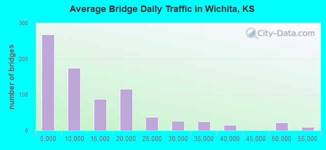
- 9,470,559Total average daily traffic
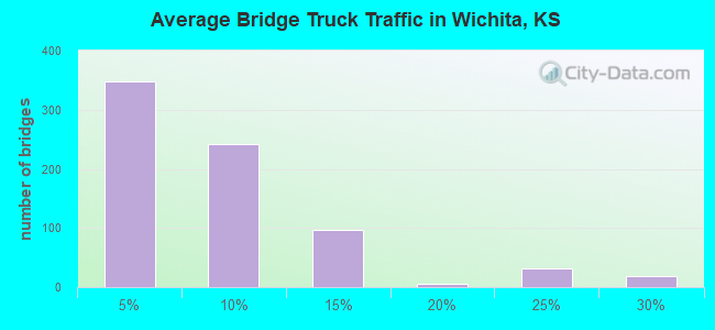
- 625,083Total average daily truck traffic
- National Bridge Inventory (NBI) Registered Bridges for Wichita
- No street view available for this location
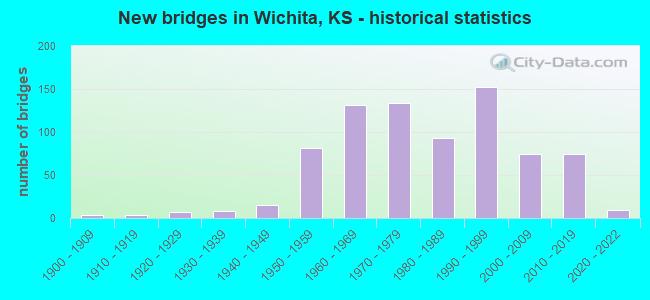
- New bridges - historical statistics
- 41900-1909
- 41910-1919
- 71920-1929
- 81930-1939
- 151940-1949
- 811950-1959
- 1311960-1969
- 1341970-1979
- 931980-1989
- 1521990-1999
- 742000-2009
- 742010-2019
- 92020-2022
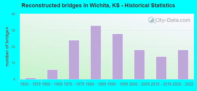
- Reconstructed bridges - Historical Statistics
- 11950-1959
- 61960-1969
- 241970-1979
- 331980-1989
- 281990-1999
- 182000-2009
- 142010-2019
- 182020-2022
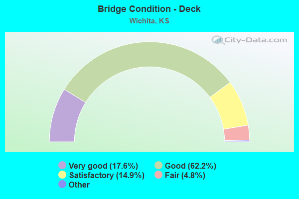
- Bridge Condition - Deck
- 17.6%Very good
- 62.2%Good
- 14.9%Satisfactory
- 4.8%Fair
- 0.5%Poor
- 0.2%Serious
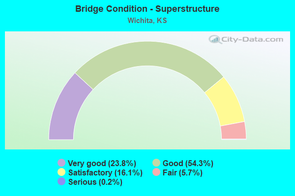
- Bridge Condition - Superstructure
- 23.8%Very good
- 54.3%Good
- 16.1%Satisfactory
- 5.7%Fair
- 0.2%Serious
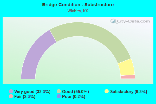
- Bridge Condition - Substructure
- 33.3%Very good
- 55.0%Good
- 9.3%Satisfactory
- 2.3%Fair
- 0.2%Poor
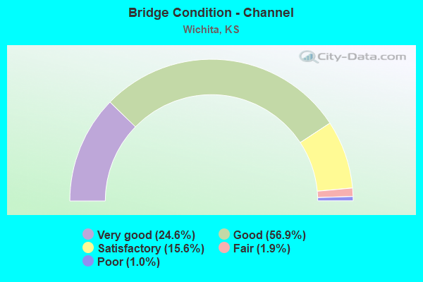
- Bridge Condition - Channel
- 24.6%Very good
- 56.9%Good
- 15.6%Satisfactory
- 1.9%Fair
- 1.0%Poor
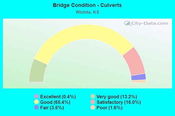
- Bridge Condition - Culverts
- 0.4%Excellent
- 13.2%Very good
- 65.4%Good
- 16.0%Satisfactory
- 3.5%Fair
- 1.6%Poor
Find on map >> Show street view
Structure Number: 870809006289, Location: 5.0W 3.1N OF HAYSVILLE (Lat: 37.609250, Lng: -97.460639), Route carried "on" structure: County highway , Year Built: 2004, Status: Open, Structure Length: 0.96m (3.15ft), Average Daily Traffic: 371 (year 2018), Truck Traffic: 7%, Average Future Daily Traffic: 600 (year 2038), Design Load: HS 20, Features Intersected: SOUTH FORK DRY CREEK, Facility Carried by Structure: 87th
Minimum Vertical Clearance: 30.47m (99.97ft), Kilometerpoint: 0.000, Lanes on structure: 2, Owner: County Highway Agency, Approaching Roadway Width: 9.1m (29.9ft), Material/Design: Concrete, Design/Construction: Culvert, Number Of Spans In Main Unit: 3, Length of Maximum Span: 3.0m (9.8ft), Curb-To-Curb Width: 9.1m (29.9ft), Out-to-Out Width: 9.8m (32.2ft)
Condition: Channel: Satisfactory, Culverts: Very good, Operating Rating: 67.2 metric tons, Method Used To Determine Operating Rating: Load Factor (LF), Inventory Rating: 40.3 metric tons, Method Used To Determine Inventory Rating: Load Factor (LF), Structural Evaluation: Equal to present desirable criteria, Deck Geometry: Equal to present minimum criteria, Waterway Adequacy: Equal to present desirable criteria, Approach Roadway Alignment: Better than present minimum criteria, Designated Inspection Frequency: Every 24 months, Inspection Date: August 2020, Other Special Inspection Date: Febuary 2021, Deck Structure Type: Concrete Cast-file-Place, Wearing Surface/Protective System: Wearing Surface: Monolithic Concrete
Find on map >> Show street view
Structure Number: 87080970634, Location: 1.0N 4.3W OF HAYSVILLE (Lat: 37.578406, Lng: -97.446608), Route carried "on" structure: County highway , Year Built: 1988, Status: Open, Structure Length: 0.82m (2.69ft), Average Daily Traffic: 21 (year 2018), Average Future Daily Traffic: 60 (year 2038), Design Load: HS 20, Features Intersected: SMALL STREAM, Facility Carried by Structure: 63rd
Minimum Vertical Clearance: 30.47m (99.97ft), Kilometerpoint: 0.000, Lanes on structure: 2, Owner: County Highway Agency, Approaching Roadway Width: 8.5m (27.9ft), Material/Design: Concrete, Design/Construction: Culvert, Number Of Spans In Main Unit: 3, Length of Maximum Span: 2.7m (8.9ft), Curb-To-Curb Width: 8.5m (27.9ft), Out-to-Out Width: 9.0m (29.5ft)
Condition: Channel: Good, Culverts: Good, Operating Rating: 40.5 metric tons, Method Used To Determine Operating Rating: Load Factor (LF), Inventory Rating: 32.4 metric tons, Method Used To Determine Inventory Rating: Load Factor (LF), Structural Evaluation: Better than present minimum criteria, Deck Geometry: Better than present minimum criteria, Waterway Adequacy: Better than present minimum criteria, Approach Roadway Alignment: Better than present minimum criteria, Designated Inspection Frequency: Every 24 months, Inspection Date: August 2020, Deck Structure Type: Concrete Cast-file-Place, Wearing Surface/Protective System: Wearing Surface: Gravel
Find on map >> Show street view
Structure Number: 8708118063, Location: 47thS, 0.8 E of 71stW (Lat: 37.607747, Lng: -97.410556), Route carried "on" structure: County highway , Year Built: 1998, Status: Open, Structure Length: 8.93m (29.30ft), Average Daily Traffic: 166 (year 2018), Truck Traffic: 3%, Average Future Daily Traffic: 203 (year 2038), Design Load: HS 20, Features Intersected: COWSKIN CREEK, Facility Carried by Structure: 47th
Minimum Vertical Clearance: 30.47m (99.97ft), Kilometerpoint: 0.000, Lanes on structure: 2, Owner: County Highway Agency, Approaching Roadway Width: 8.5m (27.9ft), Material/Design: Prestressed concrete continuous, Design/Construction: Tee Beam, Number Of Spans In Main Unit: 5, Length of Maximum Span: 18.3m (60.0ft), Curb-To-Curb Width: 8.5m (27.9ft), Out-to-Out Width: 9.1m (29.9ft)
Condition: Deck: Satisfactory, Superstructure: Very good, Substructure: Good, Channel: Fair, Operating Rating: 40.5 metric tons, Method Used To Determine Operating Rating: Load Factor (LF), Inventory Rating: 32.4 metric tons, Method Used To Determine Inventory Rating: Load Factor (LF), Structural Evaluation: Better than present minimum criteria, Deck Geometry: Equal to present minimum criteria, Waterway Adequacy: Equal to present desirable criteria, Approach Roadway Alignment: Better than present minimum criteria, Designated Inspection Frequency: Every 24 months, Inspection Date: August 2020, Deck Structure Type: Concrete Cast-file-Place, Wearing Surface/Protective System: Wearing Surface: Monolithic Concrete
Find on map >> Show street view
Structure Number: 870813006305, Location: 2.0W 1.5N OF HAYSVILLE (Lat: 37.600333, Lng: -97.407139), Route carried "on" structure: County highway 8713, Year Built: 1988, Status: Open, Structure Length: 9.39m (30.81ft), Average Daily Traffic: 3,032 (year 2018), Truck Traffic: 5%, Average Future Daily Traffic: 3,700 (year 2038), Design Load: HS 20, Features Intersected: COWSKIN CREEK, Facility Carried by Structure: 55th
Minimum Vertical Clearance: 30.47m (99.97ft), Kilometerpoint: 0.000, Lanes on structure: 2, Owner: County Highway Agency, Approaching Roadway Width: 8.5m (27.9ft), Skew: 3 degrees, Material/Design: Concrete continuous, Design/Construction: Slab, Number Of Spans In Main Unit: 6, Length of Maximum Span: 16.8m (55.1ft), Curb-To-Curb Width: 8.5m (27.9ft), Out-to-Out Width: 9.1m (29.9ft)
Condition: Deck: Satisfactory, Superstructure: Good, Substructure: Fair, Channel: Poor, Operating Rating: 70.5 metric tons, Method Used To Determine Operating Rating: Load Factor (LF), Inventory Rating: 42.2 metric tons, Method Used To Determine Inventory Rating: Load Factor (LF), Structural Evaluation: Somewhat better than minimum adequacy, Deck Geometry: Meets minimum limits, Waterway Adequacy: Equal to present desirable criteria, Approach Roadway Alignment: Better than present minimum criteria, Length Of Structure Improvement: 9.39m (30.81ft), Designated Inspection Frequency: Every 24 months, Inspection Date: August 2020, Other Special Inspection Date: Febuary 2021, Bridge Improvement Cost: $300,000, Total Project Cost: $300,000 ( Estimate for 2018), Deck Structure Type: Concrete Cast-file-Place, Wearing Surface/Protective System: Wearing Surface: Monolithic Concrete
Find on map >> Show street view
Structure Number: 870815006444, Location: 39thW, 0.6N of 111thS (Lat: 37.616806, Lng: -97.387667), Route carried "on" structure: County highway , Year Built: 1984, Status: Posted for load, Structure Length: 0.62m (2.03ft), Average Daily Traffic: 40 (year 2018), Average Future Daily Traffic: 40 (year 2038), Design Load: HS 20, Features Intersected: TRIB TO SPRING CREEK, Facility Carried by Structure: Local Rd. 39thW
Minimum Vertical Clearance: 30.47m (99.97ft), Kilometerpoint: 0.000, Lanes on structure: 2, Owner: County Highway Agency, Approaching Roadway Width: 7.3m (24.0ft), Material/Design: Steel, Design/Construction: Culvert, Number Of Spans In Main Unit: 4, Length of Maximum Span: 1.2m (3.9ft), Curb-To-Curb Width: 7.3m (24.0ft), Out-to-Out Width: 12.2m (40.0ft)
Condition: Channel: Good, Culverts: Satisfactory, Operating Rating: 15.6 metric tons, Method Used To Determine Operating Rating: Load Factor (LF), Inventory Rating: 9.4 metric tons, Method Used To Determine Inventory Rating: Load Factor (LF), Structural Evaluation: High priority of corrective action, Deck Geometry: Equal to present minimum criteria, Waterway Adequacy: Equal to present minimum criteria, Approach Roadway Alignment: Equal to present desirable criteria, Bridge Posting: Required (Relationship of Operating Rating to Maximum Legal Load: > 39.9% below), Designated Inspection Frequency: Every 24 months, Inspection Date: July 2020, Deck Structure Type: Other, Wearing Surface/Protective System: Wearing Surface: Gravel
Find on map >> Show street view
Structure Number: 87081790634, Location: 63rdS, 0.9 E of Meridian (Lat: 37.578892, Lng: -97.354006), Route carried "on" structure: County highway , Year Built: 1988, Status: Open, Structure Length: 0.79m (2.59ft), Average Daily Traffic: 2,761 (year 2018), Truck Traffic: 3%, Average Future Daily Traffic: 3,368 (year 2038), Design Load: H 20, Features Intersected: GUNZELMAN CHANNEL, Facility Carried by Structure: W 63rd
Minimum Vertical Clearance: 30.47m (99.97ft), Kilometerpoint: 0.000, Lanes on structure: 2, Owner: County Highway Agency, Approaching Roadway Width: 7.8m (25.6ft), Skew: 2 degrees, Material/Design: Concrete, Design/Construction: Culvert, Number Of Spans In Main Unit: 2, Length of Maximum Span: 4.0m (13.1ft), Curb-To-Curb Width: 24.4m (80.1ft), Out-to-Out Width: 24.8m (81.4ft)
Condition: Channel: Very good, Culverts: Very good, Operating Rating: 27.9 metric tons, Method Used To Determine Operating Rating: Load Factor (LF), Inventory Rating: 22.5 metric tons, Method Used To Determine Inventory Rating: Load Factor (LF), Structural Evaluation: Equal to present minimum criteria, Deck Geometry: Superior to present desirable criteria, Waterway Adequacy: Equal to present desirable criteria, Approach Roadway Alignment: Equal to present desirable criteria, Designated Inspection Frequency: Every 24 months, Inspection Date: August 2020, Deck Structure Type: Other, Wearing Surface/Protective System: Wearing Surface: Bituminous
Find on map >> Show street view
Structure Number: 87081950604, Location: 61stN, 0.5 E of Seneca (Lat: 37.795917, Lng: -97.362319), Route carried "on" structure: County highway , Year Built: 2007, Status: Open, Structure Length: 5.91m (19.39ft), Average Daily Traffic: 2,276 (year 2018), Truck Traffic: 5%, Average Future Daily Traffic: 2,777 (year 2038), Design Load: HS 20, Features Intersected: CHISHOLM CREEK, Facility Carried by Structure: W 61st St N
Minimum Vertical Clearance: 30.47m (99.97ft), Kilometerpoint: 0.000, Lanes on structure: 2, Owner: County Highway Agency, Approaching Roadway Width: 8.1m (26.6ft), Material/Design: Concrete continuous, Design/Construction: Slab, Number Of Spans In Main Unit: 4, Length of Maximum Span: 18.3m (60.0ft), Curb or Sidewalk Widths: Left: 3.0m (9.8ft), Right: 0.0m, Curb-To-Curb Width: 12.3m (40.4ft), Out-to-Out Width: 16.2m (53.1ft)
Condition: Deck: Good, Superstructure: Good, Substructure: Very good, Channel: Good, Operating Rating: 86.5 metric tons, Method Used To Determine Operating Rating: Load Factor (LF), Inventory Rating: 51.7 metric tons, Method Used To Determine Inventory Rating: Load Factor (LF), Structural Evaluation: Better than present minimum criteria, Deck Geometry: Equal to present minimum criteria, Waterway Adequacy: Equal to present desirable criteria, Approach Roadway Alignment: Equal to present desirable criteria, Designated Inspection Frequency: Every 24 months, Inspection Date: September 2021, Deck Structure Type: Concrete Cast-file-Place, Wearing Surface/Protective System: Wearing Surface: Monolithic Concrete
Find on map >> Show street view
Structure Number: 87082390628, Location: MacArther 0.9 E Hydraulic (Lat: 37.621525, Lng: -97.298611), Route carried "on" structure: County highway , Year Built: 1975, Year Reconstructed: 2016, Status: Open, Structure Length: 12.25m (40.19ft), Average Daily Traffic: 10,103 (year 2018), Truck Traffic: 8%, Average Future Daily Traffic: 11,100 (year 2038), Design Load: HS 20, Features Intersected: BIG ARKANSAS RIVER, Facility Carried by Structure: LOCAL RD.
Minimum Vertical Clearance: 30.47m (99.97ft), Kilometerpoint: 0.000, Lanes on structure: 4, Owner: County Highway Agency, Approaching Roadway Width: 22.3m (73.2ft), Material/Design: Prestressed concrete continuous, Design/Construction: Stringer/Multi-beam, Number Of Spans In Main Unit: 6, Length of Maximum Span: 20.7m (67.9ft), Curb or Sidewalk Widths: Left: 1.9m (6.2ft), Right: 1.9m (6.2ft), Curb-To-Curb Width: 17.1m (56.1ft), Out-to-Out Width: 18.3m (60.0ft)
Condition: Deck: Good, Superstructure: Good, Substructure: Satisfactory, Channel: Satisfactory, Operating Rating: 75.7 metric tons, Method Used To Determine Operating Rating: Load Factor (LF), Inventory Rating: 37.9 metric tons, Method Used To Determine Inventory Rating: Load Factor (LF), Structural Evaluation: Equal to present minimum criteria, Deck Geometry: Somewhat better than minimum adequacy, Waterway Adequacy: Better than present minimum criteria, Approach Roadway Alignment: Equal to present minimum criteria, Designated Inspection Frequency: Every 24 months, Inspection Date: August 2020, Deck Structure Type: Concrete Cast-file-Place, Wearing Surface/Protective System: Wearing Surface: Epoxy Overlay
Find on map >> Show street view
Structure Number: 870825005941, Location: 1.0W 4.9N OF KECHI (Lat: 37.867219, Lng: -97.315906), Route carried "on" structure: County highway , Year Built: 1954, Status: Open, Structure Length: 1.34m (4.40ft), Average Daily Traffic: 50 (year 2018), Average Future Daily Traffic: 80 (year 2038), Features Intersected: WEST FORK CHISHOLM CREEK, Facility Carried by Structure: LOCAL RD. HILLSIDE
Minimum Vertical Clearance: 30.47m (99.97ft), Kilometerpoint: 0.000, Lanes on structure: 2, Owner: County Highway Agency, Approaching Roadway Width: 8.5m (27.9ft), Material/Design: Concrete, Design/Construction: Culvert, Number Of Spans In Main Unit: 4, Length of Maximum Span: 3.0m (9.8ft), Curb-To-Curb Width: 7.9m (25.9ft), Out-to-Out Width: 8.5m (27.9ft)
Condition: Channel: Fair, Culverts: Good, Operating Rating: 22.5 metric tons, Method Used To Determine Operating Rating: Load Factor (LF), Inventory Rating: 17.1 metric tons, Method Used To Determine Inventory Rating: Load Factor (LF), Structural Evaluation: Somewhat better than minimum adequacy, Deck Geometry: Equal to present minimum criteria, Waterway Adequacy: Equal to present minimum criteria, Approach Roadway Alignment: Equal to present minimum criteria, Designated Inspection Frequency: Every 24 months, Inspection Date: August 2021, Deck Structure Type: Concrete Cast-file-Place, Wearing Surface/Protective System: Wearing Surface: Monolithic Concrete
Find on map >> Show street view
Structure Number: 87082530606, Location: 0.8W 1.0S OF KECHI (Lat: 37.781272, Lng: -97.310725), Route carried "on" structure: County highway , Year Built: 1968, Status: Posted for load, Structure Length: 3.78m (12.40ft), Average Daily Traffic: 2,026 (year 2018), Truck Traffic: 3%, Average Future Daily Traffic: 2,472 (year 2038), Design Load: H 20, Features Intersected: MIDDLE FORK CHISHOLM CK., Facility Carried by Structure: 53RD.
Minimum Vertical Clearance: 30.47m (99.97ft), Kilometerpoint: 0.000, Lanes on structure: 2, Owner: County Highway Agency, Approaching Roadway Width: 7.8m (25.6ft), Skew: 3 degrees, Material/Design: Steel continuous, Design/Construction: Stringer/Multi-beam, Number Of Spans In Main Unit: 4, Length of Maximum Span: 9.1m (29.9ft), Curb-To-Curb Width: 7.9m (25.9ft), Out-to-Out Width: 8.7m (28.5ft)
Condition: Deck: Poor, Superstructure: Satisfactory, Substructure: Fair, Channel: Poor, Operating Rating: 48.8 metric tons, Method Used To Determine Operating Rating: Load Factor (LF), Inventory Rating: 29.2 metric tons, Method Used To Determine Inventory Rating: Load Factor (LF), Structural Evaluation: Somewhat better than minimum adequacy, Deck Geometry: High priority of corrective action, Waterway Adequacy: Somewhat better than minimum adequacy, Approach Roadway Alignment: Equal to present minimum criteria, Length Of Structure Improvement: 10.97m (35.99ft), Designated Inspection Frequency: Every 24 months, Inspection Date: October 2021, Bridge Improvement Cost: $600,000, Roadway Improvement Cost: $150,000, Total Project Cost: $750,000 ( Estimate for 2021), Deck Structure Type: Concrete Cast-file-Place, Wearing Surface/Protective System: Wearing Surface: Bituminous
Find on map >> Show street view
Structure Number: 87082530632, Location: 1.6W 2.0N OF DERBY (Lat: 37.591469, Lng: -97.290625), Route carried "on" structure: County highway , Year Built: 1983, Status: Open, Structure Length: 1.04m (3.41ft), Average Daily Traffic: 522 (year 2018), Truck Traffic: 2%, Average Future Daily Traffic: 637 (year 2038), Design Load: H 20, Features Intersected: DRAINAGE DITCH, Facility Carried by Structure: LOCAL RD.
Minimum Vertical Clearance: 30.47m (99.97ft), Kilometerpoint: 0.000, Lanes on structure: 2, Owner: County Highway Agency, Approaching Roadway Width: 8.5m (27.9ft), Material/Design: Concrete, Design/Construction: Culvert, Number Of Spans In Main Unit: 4, Length of Maximum Span: 2.4m (7.9ft), Curb-To-Curb Width: 12.2m (40.0ft), Out-to-Out Width: 12.2m (40.0ft)
Condition: Channel: Good, Culverts: Satisfactory, Operating Rating: 33.2 metric tons, Method Used To Determine Operating Rating: Load Factor (LF), Inventory Rating: 19.9 metric tons, Method Used To Determine Inventory Rating: Load Factor (LF), Structural Evaluation: Somewhat better than minimum adequacy, Deck Geometry: Equal to present desirable criteria, Waterway Adequacy: Better than present minimum criteria, Approach Roadway Alignment: Equal to present desirable criteria, Designated Inspection Frequency: Every 24 months, Inspection Date: August 2020, Other Special Inspection Date: Febuary 2021, Deck Structure Type: Concrete Cast-file-Place, Wearing Surface/Protective System: Wearing Surface: Bituminous
Find on map >> Show street view
Structure Number: 870825306322, Location: Clifton, 0.7 N of 63rdS (Lat: 37.587719, Lng: -97.294000), Route carried "on" structure: County highway 6061, Year Built: 2016, Status: Open, Structure Length: 0.95m (3.12ft), Average Daily Traffic: 1,966 (year 2018), Truck Traffic: 2%, Average Future Daily Traffic: 2,399 (year 2038), Design Load: HL 93, Features Intersected: TRIB. TO ARKANSAS RIVER, Facility Carried by Structure: CLIFTON AVE
Minimum Vertical Clearance: 30.47m (99.97ft), Kilometerpoint: 0.000, Lanes on structure: 2, Owner: County Highway Agency, Approaching Roadway Width: 7.3m (24.0ft), Material/Design: Concrete, Design/Construction: Culvert, Number Of Spans In Main Unit: 3, Length of Maximum Span: 3.0m (9.8ft), Curb-To-Curb Width: 18.5m (60.7ft), Out-to-Out Width: 18.9m (62.0ft)
Condition: Channel: Very good, Culverts: Very good, Operating Rating: 43.5 metric tons, Method Used To Determine Operating Rating: Load and Resistance Factor (LRFR), Inventory Rating: 32.7 metric tons, Method Used To Determine Inventory Rating: Load and Resistance Factor (LRFR), Structural Evaluation: Equal to present desirable criteria, Deck Geometry: Superior to present desirable criteria, Waterway Adequacy: Better than present minimum criteria, Approach Roadway Alignment: Equal to present desirable criteria, Designated Inspection Frequency: Every 24 months, Inspection Date: August 2020, Deck Structure Type: Concrete Cast-file-Place, Wearing Surface/Protective System: Wearing Surface: Bituminous, Membrane: Preformed Fabric, Deck Protection: Epoxy Coated Reinforcing
Find on map >> Show street view
Structure Number: 87082540632, Location: 55thS, 0.1 E of Clifton (Lat: 37.591472, Lng: -97.293528), Route carried "on" structure: City street 2589, Year Built: 2013, Status: Open, Structure Length: 0.77m (2.53ft), Average Daily Traffic: 522 (year 2018), Truck Traffic: 2%, Average Future Daily Traffic: 637 (year 2038), Design Load: HS 20, Features Intersected: DRAINAGE DITCH, Facility Carried by Structure: 55thS Urbn Lcl Rd
Minimum Vertical Clearance: 30.47m (99.97ft), Kilometerpoint: 0.000, Lanes on structure: 2, Owner: County Highway Agency, Approaching Roadway Width: 7.6m (24.9ft), Material/Design: Concrete, Design/Construction: Culvert, Number Of Spans In Main Unit: 3, Length of Maximum Span: 2.4m (7.9ft), Curb-To-Curb Width: 12.2m (40.0ft), Out-to-Out Width: 12.7m (41.7ft)
Condition: Channel: Very good, Culverts: Very good, Operating Rating: 63.5 metric tons, Method Used To Determine Operating Rating: Load Factor (LF), Inventory Rating: 38.0 metric tons, Method Used To Determine Inventory Rating: Load Factor (LF), Structural Evaluation: Equal to present desirable criteria, Deck Geometry: Equal to present desirable criteria, Waterway Adequacy: Better than present minimum criteria, Approach Roadway Alignment: Equal to present desirable criteria, Designated Inspection Frequency: Every 24 months, Inspection Date: August 2020, Other Special Inspection Date: Febuary 2021, Deck Structure Type: Concrete Cast-file-Place, Wearing Surface/Protective System: Wearing Surface: Bituminous, Deck Protection: Epoxy Coated Reinforcing
Find on map >> Show street view
Structure Number: 87082560632, Location: 1.4W 2.0N OF DERBY (Lat: 37.591489, Lng: -97.286647), Route carried "on" structure: County highway , Year Built: 2005, Status: Open, Structure Length: 5.09m (16.70ft), Average Daily Traffic: 522 (year 2018), Truck Traffic: 2%, Average Future Daily Traffic: 637 (year 2038), Design Load: HS 20, Features Intersected: TRIB. BIG ARKANSAS RIVER, Facility Carried by Structure: LOCAL RD.
Minimum Vertical Clearance: 30.47m (99.97ft), Kilometerpoint: 0.000, Lanes on structure: 2, Owner: County Highway Agency, Approaching Roadway Width: 8.5m (27.9ft), Material/Design: Prestressed concrete continuous, Design/Construction: Slab, Number Of Spans In Main Unit: 3, Length of Maximum Span: 20.0m (65.6ft), Curb-To-Curb Width: 8.6m (28.2ft), Out-to-Out Width: 9.2m (30.2ft)
Condition: Deck: Very good, Superstructure: Very good, Substructure: Very good, Channel: Good, Inventory Rating: 15.3 metric tons, Method Used To Determine Inventory Rating: Load Factor (LF), Structural Evaluation: Meets minimum limits, Deck Geometry: Somewhat better than minimum adequacy, Waterway Adequacy: Equal to present desirable criteria, Approach Roadway Alignment: Equal to present minimum criteria, Designated Inspection Frequency: Every 24 months, Inspection Date: August 2020, Other Special Inspection Date: Febuary 2021, Deck Structure Type: Concrete Cast-file-Place, Wearing Surface/Protective System: Wearing Surface: Monolithic Concrete
Find on map >> Show street view
Structure Number: 87083350628, Location: MacArthur,.4EofWebb/95thE (Lat: 37.621000, Lng: -97.218000), Route carried "on" structure: County highway 21079, Year Built: 2016, Status: Open, Structure Length: 1.18m (3.87ft), Average Daily Traffic: 600 (year 2018), Truck Traffic: 6%, Average Future Daily Traffic: 720 (year 2038), Design Load: HL 93, Features Intersected: TRIB. TO SPRING CREEK, Facility Carried by Structure: LOCAL ROAD 39th
Minimum Vertical Clearance: 30.47m (99.97ft), Kilometerpoint: 0.000, Lanes on structure: 2, Owner: County Highway Agency, Approaching Roadway Width: 5.1m (16.7ft), Material/Design: Concrete, Design/Construction: Culvert, Number Of Spans In Main Unit: 3, Length of Maximum Span: 3.7m (12.1ft), Curb-To-Curb Width: 8.6m (28.2ft), Out-to-Out Width: 9.3m (30.5ft)
Condition: Channel: Good, Culverts: Very good, Operating Rating: 43.5 metric tons, Method Used To Determine Operating Rating: Load and Resistance Factor (LRFR), Inventory Rating: 32.7 metric tons, Method Used To Determine Inventory Rating: Load and Resistance Factor (LRFR), Structural Evaluation: Equal to present desirable criteria, Deck Geometry: Somewhat better than minimum adequacy, Waterway Adequacy: Somewhat better than minimum adequacy, Approach Roadway Alignment: Better than present minimum criteria, Designated Inspection Frequency: Every 24 months, Inspection Date: September 2020, Deck Structure Type: Concrete Cast-file-Place, Wearing Surface/Protective System: Wearing Surface: Gravel
Find on map >> Show street view
Structure Number: 87083360628, Location: 2.6E 4.0N OF DERBY (Lat: 37.620997, Lng: -97.231656), Route carried "on" structure: County highway , Year Built: 1979, Status: Open, Structure Length: 0.98m (3.22ft), Average Daily Traffic: 600 (year 2018), Truck Traffic: 6%, Average Future Daily Traffic: 800 (year 2038), Design Load: H 20, Features Intersected: SPRING CREEK, Facility Carried by Structure: 39th
Minimum Vertical Clearance: 30.47m (99.97ft), Kilometerpoint: 0.000, Lanes on structure: 2, Owner: County Highway Agency, Approaching Roadway Width: 8.5m (27.9ft), Material/Design: Concrete, Design/Construction: Culvert, Number Of Spans In Main Unit: 3, Length of Maximum Span: 3.4m (11.2ft), Curb-To-Curb Width: 11.0m (36.1ft), Out-to-Out Width: 11.4m (37.4ft)
Condition: Channel: Satisfactory, Culverts: Good, Operating Rating: 27.9 metric tons, Method Used To Determine Operating Rating: Load Factor (LF), Inventory Rating: 22.5 metric tons, Method Used To Determine Inventory Rating: Load Factor (LF), Structural Evaluation: Equal to present minimum criteria, Deck Geometry: Better than present minimum criteria, Waterway Adequacy: Somewhat better than minimum adequacy, Approach Roadway Alignment: Better than present minimum criteria, Designated Inspection Frequency: Every 24 months, Inspection Date: September 2020, Deck Structure Type: Concrete Cast-file-Place, Wearing Surface/Protective System: Wearing Surface: Gravel
Find on map >> Show street view
Structure Number: 8708339061, Location: 0.9E WICHITA CITY LIMITS (Lat: 37.752269, Lng: -97.226247), Route carried "on" structure: County highway 8710, Year Built: 1985, Status: Open, Structure Length: 0.85m (2.79ft), Average Daily Traffic: 334 (year 2018), Truck Traffic: 9%, Average Future Daily Traffic: 408 (year 2038), Design Load: H 20, Features Intersected: INDIANOLA CREEK, Facility Carried by Structure: MINOR COL
Minimum Vertical Clearance: 30.47m (99.97ft), Kilometerpoint: 0.000, Lanes on structure: 2, Owner: County Highway Agency, Approaching Roadway Width: 7.3m (24.0ft), Material/Design: Wood or Timber, Design/Construction: Slab, Number Of Spans In Main Unit: 1, Length of Maximum Span: 8.2m (26.9ft), Curb-To-Curb Width: 7.2m (23.6ft), Out-to-Out Width: 7.2m (23.6ft)
Condition: Deck: Good, Superstructure: Good, Substructure: Satisfactory, Channel: Satisfactory, Operating Rating: 40.6 metric tons, Method Used To Determine Operating Rating: Allowable Stress (AS), Inventory Rating: 28.8 metric tons, Method Used To Determine Inventory Rating: Allowable Stress (AS), Structural Evaluation: Equal to present minimum criteria, Deck Geometry: Meets minimum limits, Waterway Adequacy: Better than present minimum criteria, Approach Roadway Alignment: Somewhat better than minimum adequacy, Designated Inspection Frequency: Every 24 months, Inspection Date: October 2021, Deck Structure Type: Wood or Timber, Wearing Surface/Protective System: Wearing Surface: Bituminous
Find on map >> Show street view
Structure Number: 870837006102, Location: 127thE, 0.8 N of 29thN (Lat: 37.749878, Lng: -97.189658), Route carried "on" structure: County highway , Year Built: 1980, Status: Open, Structure Length: 1.34m (4.40ft), Average Daily Traffic: 299 (year 2018), Truck Traffic: 3%, Average Future Daily Traffic: 365 (year 2038), Design Load: H 20, Features Intersected: DRY CREEK, Facility Carried by Structure: LOCAL RD.
Minimum Vertical Clearance: 30.47m (99.97ft), Kilometerpoint: 0.000, Lanes on structure: 2, Owner: County Highway Agency, Approaching Roadway Width: 7.4m (24.3ft), Material/Design: Concrete, Design/Construction: Culvert, Number Of Spans In Main Unit: 4, Length of Maximum Span: 3.4m (11.2ft), Curb-To-Curb Width: 9.7m (31.8ft), Out-to-Out Width: 10.2m (33.5ft)
Condition: Channel: Fair, Culverts: Good, Operating Rating: 27.9 metric tons, Method Used To Determine Operating Rating: Load Factor (LF), Inventory Rating: 22.5 metric tons, Method Used To Determine Inventory Rating: Load Factor (LF), Structural Evaluation: Equal to present minimum criteria, Deck Geometry: Equal to present minimum criteria, Waterway Adequacy: Better than present minimum criteria, Approach Roadway Alignment: Equal to present minimum criteria, Designated Inspection Frequency: Every 24 months, Inspection Date: October 2021, Deck Structure Type: Concrete Cast-file-Place, Wearing Surface/Protective System: Wearing Surface: Bituminous
Find on map >> Show street view
Structure Number: 870837006246, Location: 127thE, 0.4 N of 31stS (Lat: 37.641903, Lng: -97.189606), Route carried "on" structure: County highway , Year Built: 1992, Status: Open, Structure Length: 0.76m (2.49ft), Average Daily Traffic: 565 (year 2018), Truck Traffic: 5%, Average Future Daily Traffic: 689 (year 2038), Design Load: HS 20, Features Intersected: TRIB. TO FOUR MILE CREEK, Facility Carried by Structure: 127th
Minimum Vertical Clearance: 30.47m (99.97ft), Kilometerpoint: 0.000, Lanes on structure: 2, Owner: County Highway Agency, Approaching Roadway Width: 8.5m (27.9ft), Material/Design: Concrete, Design/Construction: Culvert, Number Of Spans In Main Unit: 3, Length of Maximum Span: 2.7m (8.9ft), Curb-To-Curb Width: 8.5m (27.9ft), Out-to-Out Width: 9.0m (29.5ft)
Condition: Channel: Good, Culverts: Good, Operating Rating: 40.5 metric tons, Method Used To Determine Operating Rating: Load Factor (LF), Inventory Rating: 32.4 metric tons, Method Used To Determine Inventory Rating: Load Factor (LF), Structural Evaluation: Better than present minimum criteria, Deck Geometry: Somewhat better than minimum adequacy, Waterway Adequacy: Equal to present desirable criteria, Approach Roadway Alignment: Equal to present minimum criteria, Designated Inspection Frequency: Every 24 months, Inspection Date: September 2020, Deck Structure Type: Concrete Cast-file-Place, Wearing Surface/Protective System: Wearing Surface: Bituminous
Find on map >> Show street view
Structure Number: 8708372061, Location: 37thN, 0.2 E of 127thE (Lat: 37.752339, Lng: -97.185564), Route carried "on" structure: County highway , Year Built: 1994, Status: Open, Structure Length: 0.94m (3.08ft), Average Daily Traffic: 200 (year 2018), Truck Traffic: 4%, Average Future Daily Traffic: 244 (year 2038), Design Load: HS 20, Features Intersected: TRIB. TO DRY CREEK, Facility Carried by Structure: 37th N
Minimum Vertical Clearance: 30.47m (99.97ft), Kilometerpoint: 0.000, Lanes on structure: 2, Owner: County Highway Agency, Approaching Roadway Width: 7.4m (24.3ft), Material/Design: Concrete, Design/Construction: Culvert, Number Of Spans In Main Unit: 3, Length of Maximum Span: 3.4m (11.2ft), Curb-To-Curb Width: 8.5m (27.9ft), Out-to-Out Width: 9.1m (29.9ft)
Condition: Channel: Good, Culverts: Good, Operating Rating: 40.5 metric tons, Method Used To Determine Operating Rating: Load Factor (LF), Inventory Rating: 32.4 metric tons, Method Used To Determine Inventory Rating: Load Factor (LF), Structural Evaluation: Better than present minimum criteria, Deck Geometry: Equal to present minimum criteria, Waterway Adequacy: Equal to present desirable criteria, Approach Roadway Alignment: Equal to present minimum criteria, Designated Inspection Frequency: Every 24 months, Inspection Date: October 2021, Deck Structure Type: Concrete Cast-file-Place, Wearing Surface/Protective System: Wearing Surface: Monolithic Concrete
Find on map >> Show street view
Structure Number: 87083790626, Location: 31stS, 0.9 E of 127thE (Lat: 37.635767, Lng: -97.171614), Route carried "on" structure: County highway , Year Built: 1945, Year Reconstructed: 1960, Status: Open, Structure Length: 0.82m (2.69ft), Average Daily Traffic: 657 (year 2018), Truck Traffic: 2%, Average Future Daily Traffic: 802 (year 2038), Features Intersected: TRIB. TO FOUR MILE CREEK, Facility Carried by Structure: 31st
Minimum Vertical Clearance: 30.47m (99.97ft), Kilometerpoint: 0.000, Lanes on structure: 2, Owner: County Highway Agency, Approaching Roadway Width: 9.1m (29.9ft), Material/Design: Concrete, Design/Construction: Culvert, Number Of Spans In Main Unit: 3, Length of Maximum Span: 2.7m (8.9ft), Curb-To-Curb Width: 9.1m (29.9ft), Out-to-Out Width: 12.8m (42.0ft)
Condition: Channel: Satisfactory, Culverts: Fair, Operating Rating: 22.5 metric tons, Method Used To Determine Operating Rating: Load Factor (LF), Inventory Rating: 17.1 metric tons, Method Used To Determine Inventory Rating: Load Factor (LF), Structural Evaluation: Meets minimum limits, Deck Geometry: Equal to present minimum criteria, Waterway Adequacy: Equal to present minimum criteria, Approach Roadway Alignment: Better than present minimum criteria, Length Of Structure Improvement: 7.62m (25.00ft), Designated Inspection Frequency: Every 24 months, Inspection Date: September 2020, Bridge Improvement Cost: $120,000, Roadway Improvement Cost: $800,000, Total Project Cost: $200,000 ( Estimate for 2018), Deck Structure Type: Other, Wearing Surface/Protective System: Wearing Surface: Bituminous
Find on map >> Show street view
Structure Number: 870839006107, Location: 143rdE, 0.4 N of 29thN (Lat: 37.743056, Lng: -97.170894), Route carried "on" structure: County highway , Year Built: 2006, Status: Open, Structure Length: 3.12m (10.24ft), Average Daily Traffic: 40 (year 2018), Average Future Daily Traffic: 60 (year 2038), Design Load: HS 20, Features Intersected: DRY CREEK, Facility Carried by Structure: 143rd
Minimum Vertical Clearance: 30.47m (99.97ft), Kilometerpoint: 0.000, Lanes on structure: 2, Owner: County Highway Agency, Approaching Roadway Width: 7.5m (24.6ft), Material/Design: Concrete continuous, Design/Construction: Slab, Number Of Spans In Main Unit: 3, Length of Maximum Span: 12.2m (40.0ft), Curb-To-Curb Width: 8.5m (27.9ft), Out-to-Out Width: 9.1m (29.9ft)
Condition: Deck: Very good, Superstructure: Very good, Substructure: Very good, Channel: Very good, Operating Rating: 83.2 metric tons, Method Used To Determine Operating Rating: Load Factor (LF), Inventory Rating: 49.8 metric tons, Method Used To Determine Inventory Rating: Load Factor (LF), Structural Evaluation: Equal to present desirable criteria, Deck Geometry: Better than present minimum criteria, Waterway Adequacy: Equal to present desirable criteria, Approach Roadway Alignment: Equal to present minimum criteria, Designated Inspection Frequency: Every 24 months, Inspection Date: October 2021, Deck Structure Type: Concrete Cast-file-Place, Wearing Surface/Protective System: Wearing Surface: Monolithic Concrete
Find on map >> Show street view
Structure Number: 870839006227, Location: 3.0E WICHITA CITY LIMITS (Lat: 37.652925, Lng: -97.171233), Route carried "on" structure: County highway 6745, Year Built: 2020, Status: Open, Structure Length: 1.35m (4.43ft), Average Daily Traffic: 3,263 (year 2016), Truck Traffic: 10%, Average Future Daily Traffic: 3,950 (year 2040), Design Load: HL 93, Features Intersected: SPRING BR. FOUR MILE CK., Facility Carried by Structure: 143rd
Minimum Vertical Clearance: 30.47m (99.97ft), Kilometerpoint: 0.000, Lanes on structure: 2, Owner: County Highway Agency, Approaching Roadway Width: 12.1m (39.7ft), Material/Design: Concrete, Design/Construction: Culvert, Number Of Spans In Main Unit: 4, Length of Maximum Span: 3.0m (9.8ft), Curb or Sidewalk Widths: Left: 4.3m (14.1ft), Right: 0.0m, Curb-To-Curb Width: 12.2m (40.0ft), Out-to-Out Width: 17.6m (57.7ft)
Condition: Channel: Very good, Culverts: Very good, Operating Rating: 66.3 metric tons, Method Used To Determine Operating Rating: Load Factor (LF), Inventory Rating: 39.7 metric tons, Method Used To Determine Inventory Rating: Load Factor (LF), Structural Evaluation: Equal to present desirable criteria, Deck Geometry: Equal to present minimum criteria, Waterway Adequacy: Equal to present desirable criteria, Approach Roadway Alignment: Equal to present desirable criteria, Designated Inspection Frequency: Every 24 months, Inspection Date: October 2020, Deck Structure Type: Concrete Cast-file-Place, Wearing Surface/Protective System: Wearing Surface: Bituminous, Deck Protection: Epoxy Coated Reinforcing
Find on map >> Show street view
Structure Number: 870839006241, Location: 143rdE, 0.9 N of 31stS (Lat: 37.649792, Lng: -97.171231), Route carried "on" structure: County highway , Year Built: 1963, Status: Open, Structure Length: 1.10m (3.61ft), Average Daily Traffic: 500 (year 2018), Truck Traffic: 6%, Average Future Daily Traffic: 610 (year 2038), Features Intersected: TRIB. TO FOUR MILE CREEK, Facility Carried by Structure: 143rd
Minimum Vertical Clearance: 30.47m (99.97ft), Kilometerpoint: 0.000, Lanes on structure: 2, Owner: County Highway Agency, Approaching Roadway Width: 8.5m (27.9ft), Material/Design: Steel, Design/Construction: Stringer/Multi-beam, Number Of Spans In Main Unit: 1, Length of Maximum Span: 10.1m (33.1ft), Curb-To-Curb Width: 8.0m (26.2ft), Out-to-Out Width: 8.9m (29.2ft)
Condition: Deck: Fair, Superstructure: Fair, Substructure: Poor, Channel: Poor, Operating Rating: 71.6 metric tons, Method Used To Determine Operating Rating: Load Factor (LF), Inventory Rating: 42.8 metric tons, Method Used To Determine Inventory Rating: Load Factor (LF), Structural Evaluation: Meets minimum limits, Deck Geometry: Somewhat better than minimum adequacy, Waterway Adequacy: Equal to present minimum criteria, Approach Roadway Alignment: Equal to present minimum criteria, Length Of Structure Improvement: 7.62m (25.00ft), Designated Inspection Frequency: Every 24 months, Inspection Date: September 2020, Bridge Improvement Cost: $550,000, Roadway Improvement Cost: $200,000, Total Project Cost: $750,000 ( Estimate for 2018), Deck Structure Type: Concrete Cast-file-Place, Wearing Surface/Protective System: Wearing Surface: Gravel
Find on map >> Show street view
Structure Number: 870839006246, Location: 143rdE, 0.4 N of 31stS (Lat: 37.640892, Lng: -97.171311), Route carried "on" structure: County highway , Year Built: 1982, Status: Open, Structure Length: 0.76m (2.49ft), Average Daily Traffic: 500 (year 2018), Truck Traffic: 6%, Average Future Daily Traffic: 610 (year 2038), Design Load: H 20, Features Intersected: TRIB. TO FOUR MILE CREEK, Facility Carried by Structure: 143rd
Minimum Vertical Clearance: 30.47m (99.97ft), Kilometerpoint: 0.000, Lanes on structure: 2, Owner: County Highway Agency, Approaching Roadway Width: 8.1m (26.6ft), Skew: 3 degrees, Material/Design: Concrete, Design/Construction: Culvert, Number Of Spans In Main Unit: 2, Length of Maximum Span: 3.7m (12.1ft), Curb-To-Curb Width: 9.9m (32.5ft), Out-to-Out Width: 10.4m (34.1ft)
Condition: Channel: Satisfactory, Culverts: Satisfactory, Operating Rating: 27.9 metric tons, Method Used To Determine Operating Rating: Load Factor (LF), Inventory Rating: 22.5 metric tons, Method Used To Determine Inventory Rating: Load Factor (LF), Structural Evaluation: Equal to present minimum criteria, Deck Geometry: Equal to present minimum criteria, Waterway Adequacy: Equal to present minimum criteria, Approach Roadway Alignment: Better than present minimum criteria, Designated Inspection Frequency: Every 24 months, Inspection Date: September 2020, Deck Structure Type: Concrete Cast-file-Place, Wearing Surface/Protective System: Wearing Surface: Gravel
Find on map >> Show street view
Structure Number: 870839006249, Location: 143rdE, 0.1 N of 31stS (Lat: 37.638142, Lng: -97.171333), Route carried "on" structure: County highway , Year Built: 1981, Status: Open, Structure Length: 0.76m (2.49ft), Average Daily Traffic: 500 (year 2018), Truck Traffic: 6%, Average Future Daily Traffic: 610 (year 2038), Design Load: H 20, Features Intersected: TRIB. TO FOUR MILE CREEK, Facility Carried by Structure: 143rd
Minimum Vertical Clearance: 30.47m (99.97ft), Kilometerpoint: 0.000, Lanes on structure: 2, Owner: County Highway Agency, Approaching Roadway Width: 8.1m (26.6ft), Skew: 3 degrees, Material/Design: Concrete, Design/Construction: Culvert, Number Of Spans In Main Unit: 2, Length of Maximum Span: 3.7m (12.1ft), Curb-To-Curb Width: 9.8m (32.2ft), Out-to-Out Width: 10.3m (33.8ft)
Condition: Channel: Satisfactory, Culverts: Good, Operating Rating: 27.9 metric tons, Method Used To Determine Operating Rating: Load Factor (LF), Inventory Rating: 22.5 metric tons, Method Used To Determine Inventory Rating: Load Factor (LF), Structural Evaluation: Equal to present minimum criteria, Deck Geometry: Equal to present minimum criteria, Waterway Adequacy: Equal to present minimum criteria, Approach Roadway Alignment: Better than present minimum criteria, Designated Inspection Frequency: Every 24 months, Inspection Date: September 2020, Deck Structure Type: Concrete Cast-file-Place, Wearing Surface/Protective System: Wearing Surface: Gravel
Find on map >> Show street view
Structure Number: 8708391061, Location: 37thN, 0.1 E of 143rdE (Lat: 37.752394, Lng: -97.170367), Route carried "on" structure: County highway , Year Built: 1997, Status: Open, Structure Length: 0.98m (3.22ft), Average Daily Traffic: 50 (year 2018), Average Future Daily Traffic: 80 (year 2038), Design Load: HS 20, Features Intersected: TRIB. TO DRY CREEK, Facility Carried by Structure: LOCAL RD.
Minimum Vertical Clearance: 30.47m (99.97ft), Kilometerpoint: 0.000, Lanes on structure: 2, Owner: County Highway Agency, Approaching Roadway Width: 7.4m (24.3ft), Material/Design: Concrete, Design/Construction: Culvert, Number Of Spans In Main Unit: 3, Length of Maximum Span: 3.4m (11.2ft), Curb-To-Curb Width: 8.5m (27.9ft), Out-to-Out Width: 9.0m (29.5ft)
Condition: Channel: Very good, Culverts: Very good, Operating Rating: 40.5 metric tons, Method Used To Determine Operating Rating: Load Factor (LF), Inventory Rating: 32.4 metric tons, Method Used To Determine Inventory Rating: Load Factor (LF), Structural Evaluation: Equal to present desirable criteria, Deck Geometry: Better than present minimum criteria, Waterway Adequacy: Equal to present desirable criteria, Approach Roadway Alignment: Better than present minimum criteria, Designated Inspection Frequency: Every 24 months, Inspection Date: October 2021, Deck Structure Type: Concrete Cast-file-Place, Wearing Surface/Protective System: Wearing Surface: Gravel
Find on map >> Show street view
Structure Number: 960779006504, Location: 1.6N 3.0E OF MILTON (Lat: 37.453953, Lng: -97.715561), Route carried "on" structure: County highway , Year Built: 1920, Status: Open, Structure Length: 1.80m (5.91ft), Average Daily Traffic: 20 (year 2013), Average Future Daily Traffic: 20 (year 2041), Features Intersected: NORTH BRANCH SLATE CREEK, Facility Carried by Structure: LOCAL 11-2-4
Minimum Vertical Clearance: 30.47m (99.97ft), Kilometerpoint: 0.000, Lanes on structure: 2, Owner: County Highway Agency, Approaching Roadway Width: 6.1m (20.0ft), Material/Design: Concrete, Design/Construction: Slab, Number Of Spans In Main Unit: 3, Length of Maximum Span: 5.5m (18.0ft), Curb-To-Curb Width: 6.1m (20.0ft), Out-to-Out Width: 6.4m (21.0ft)
Condition: Deck: Fair, Superstructure: Fair, Substructure: Satisfactory, Channel: Satisfactory, Operating Rating: 38.7 metric tons, Method Used To Determine Operating Rating: Load Factor (LF), Inventory Rating: 23.4 metric tons, Method Used To Determine Inventory Rating: Load Factor (LF), Structural Evaluation: Somewhat better than minimum adequacy, Deck Geometry: Somewhat better than minimum adequacy, Waterway Adequacy: High priority of corrective action, Approach Roadway Alignment: Equal to present minimum criteria, Designated Inspection Frequency: Every 24 months, Inspection Date: June 2021, Deck Structure Type: Concrete Cast-file-Place
Find on map >> Show street view
Structure Number: 960781006502, Location: 4.9N 3.0W CONWAY SPRINGS (Lat: 37.458136, Lng: -97.697428), Route carried "on" structure: County highway , Year Built: 1970, Status: Posted for load, Structure Length: 2.96m (9.71ft), Average Daily Traffic: 10 (year 2012), Truck Traffic: 1%, Average Future Daily Traffic: 10 (year 2041), Features Intersected: SLATE CREEK, Facility Carried by Structure: LOCAL 13-2-2
Minimum Vertical Clearance: 30.47m (99.97ft), Kilometerpoint: 0.000, Lanes on structure: 2, Owner: County Highway Agency, Approaching Roadway Width: 7.3m (24.0ft), Material/Design: Wood or Timber, Design/Construction: Stringer/Multi-beam, Number Of Spans In Main Unit: 5, Length of Maximum Span: 5.8m (19.0ft), Curb-To-Curb Width: 7.9m (25.9ft), Out-to-Out Width: 8.0m (26.2ft)
Condition: Deck: Satisfactory, Superstructure: Satisfactory, Substructure: Satisfactory, Channel: Satisfactory, Operating Rating: 11.3 metric tons, Method Used To Determine Operating Rating: Load Factor (LF), Inventory Rating: 7.7 metric tons, Method Used To Determine Inventory Rating: Load Factor (LF), Structural Evaluation: High priority of corrective action, Deck Geometry: Equal to present minimum criteria, Waterway Adequacy: Equal to present minimum criteria, Approach Roadway Alignment: Equal to present desirable criteria, Bridge Posting: Required (Relationship of Operating Rating to Maximum Legal Load: > 39.9% below), Designated Inspection Frequency: Every 24 months, Inspection Date: June 2021, Deck Structure Type: Concrete Cast-file-Place
Find on map >> Show street view
Structure Number: 430400870000205, Location: at Glenmoor Ct (Lat: 37.669472, Lng: -97.192778), Route carried "on" structure: City street , Year Built: 2005, Status: Open, Structure Length: 1.00m (3.28ft), Average Daily Traffic: 450 (year 2006), Truck Traffic: 1%, Average Future Daily Traffic: 450 (year 2039), Design Load: HS 20, Features Intersected: Spring Creek Trib., Facility Carried by Structure: Glenmoor Street
Minimum Vertical Clearance: 30.47m (99.97ft), Kilometerpoint: 0.000, Lanes on structure: 2, Owner: City or Municipal Highway Agency, Approaching Roadway Width: 10.0m (32.8ft), Material/Design: Concrete, Design/Construction: Culvert, Number Of Spans In Main Unit: 3, Length of Maximum Span: 3.0m (9.8ft), Curb or Sidewalk Widths: Left: 1.5m (4.9ft), Right: 0.0m
Condition: Channel: Good, Culverts: Good, Operating Rating: 62.6 metric tons, Method Used To Determine Operating Rating: Load Factor (LF), Inventory Rating: 37.2 metric tons, Method Used To Determine Inventory Rating: Load Factor (LF), Structural Evaluation: Better than present minimum criteria, Waterway Adequacy: Equal to present desirable criteria, Approach Roadway Alignment: Better than present minimum criteria, Designated Inspection Frequency: Every 24 months, Inspection Date: September 2021, Wearing Surface/Protective System: Wearing Surface: Bituminous
Find on map >> Show street view
Structure Number: 430400870000206, Location: at Glenmoor St (Lat: 37.669939, Lng: -97.192169), Route carried "on" structure: City street , Year Built: 2005, Status: Open, Structure Length: 0.67m (2.20ft), Average Daily Traffic: 150 (year 2006), Truck Traffic: 1%, Average Future Daily Traffic: 200 (year 2039), Design Load: HS 20, Features Intersected: Spring Creek Trib, Facility Carried by Structure: Glenmoor Court
Minimum Vertical Clearance: 30.47m (99.97ft), Kilometerpoint: 0.000, Lanes on structure: 2, Owner: City or Municipal Highway Agency, Approaching Roadway Width: 8.5m (27.9ft), Material/Design: Concrete, Design/Construction: Culvert, Number Of Spans In Main Unit: 2, Length of Maximum Span: 3.0m (9.8ft)
Condition: Channel: Good, Culverts: Good, Operating Rating: 60.8 metric tons, Method Used To Determine Operating Rating: Load Factor (LF), Inventory Rating: 37.2 metric tons, Method Used To Determine Inventory Rating: Load Factor (LF), Structural Evaluation: Better than present minimum criteria, Waterway Adequacy: Equal to present desirable criteria, Approach Roadway Alignment: Better than present minimum criteria, Designated Inspection Frequency: Every 24 months, Inspection Date: September 2021, Wearing Surface/Protective System: Wearing Surface: Bituminous
Find on map >> Show street view
Structure Number: 430400870000269, Location: East of 127th East (Lat: 37.727144, Lng: -97.185633), Route carried "on" structure: City street , Year Built: 2005, Status: Open, Structure Length: 0.78m (2.56ft), Average Daily Traffic: 450 (year 2006), Truck Traffic: 1%, Average Future Daily Traffic: 500 (year 2039), Design Load: HS 20, Features Intersected: Trib to Fourmile Creek, Facility Carried by Structure: Camden Chase
Minimum Vertical Clearance: 30.47m (99.97ft), Kilometerpoint: 0.000, Lanes on structure: 2, Owner: City or Municipal Highway Agency, Approaching Roadway Width: 10.3m (33.8ft), Material/Design: Concrete, Design/Construction: Culvert, Number Of Spans In Main Unit: 2, Length of Maximum Span: 3.7m (12.1ft), Curb or Sidewalk Widths: Left: 1.8m (5.9ft), Right: 0.0m
Condition: Channel: Good, Culverts: Good, Operating Rating: 60.8 metric tons, Method Used To Determine Operating Rating: Load Factor (LF), Inventory Rating: 36.3 metric tons, Method Used To Determine Inventory Rating: Load Factor (LF), Structural Evaluation: Better than present minimum criteria, Waterway Adequacy: Equal to present desirable criteria, Approach Roadway Alignment: Better than present minimum criteria, Designated Inspection Frequency: Every 24 months, Inspection Date: September 2021, Wearing Surface/Protective System: Wearing Surface: Bituminous
Find on map >> Show street view
Structure Number: 430400870000271, Location: 0.25 mi. E. of N. Oliver (Lat: 37.737778, Lng: -97.273889), Route carried "on" structure: City street , Year Built: 2010, Status: Open, Structure Length: 1.04m (3.41ft), Average Daily Traffic: 20 (year 2010), Average Future Daily Traffic: 20 (year 2039), Design Load: HS 20, Features Intersected: East Fork Chisholm Creek, Facility Carried by Structure: Driveway
Minimum Vertical Clearance: 30.47m (99.97ft), Kilometerpoint: 0.000, Lanes on structure: 2, Owner: City or Municipal Highway Agency, Approaching Roadway Width: 7.3m (24.0ft), Material/Design: Concrete, Design/Construction: Culvert, Number Of Spans In Main Unit: 2, Length of Maximum Span: 4.9m (16.1ft), Curb-To-Curb Width: 13.4m (44.0ft), Out-to-Out Width: 14.3m (46.9ft)
Condition: Channel: Good, Culverts: Good, Operating Rating: 57.2 metric tons, Method Used To Determine Operating Rating: Load Factor (LF), Inventory Rating: 34.3 metric tons, Method Used To Determine Inventory Rating: Load Factor (LF), Structural Evaluation: Better than present minimum criteria, Deck Geometry: Superior to present desirable criteria, Waterway Adequacy: Equal to present desirable criteria, Approach Roadway Alignment: Equal to present minimum criteria, Designated Inspection Frequency: Every 24 months, Inspection Date: October 2021, Deck Structure Type: Concrete Cast-file-Place, Wearing Surface/Protective System: Wearing Surface: Monolithic Concrete
Find on map >> Show street view
Structure Number: 430400870000273, Location: Greenwich, N of Bayley (Lat: 37.671011, Lng: -97.207842), Route carried "on" structure: City street 6675, Year Built: 2010, Status: Open, Structure Length: 2.32m (7.61ft), Average Daily Traffic: 12,000 (year 2007), Truck Traffic: 7%, Average Future Daily Traffic: 15,000 (year 2039), Design Load: HS 20, Features Intersected: Spring Branch, Facility Carried by Structure: Greenwich Road
Minimum Vertical Clearance: 30.47m (99.97ft), Kilometerpoint: 0.000, Lanes on structure: 5, Owner: City or Municipal Highway Agency, Approaching Roadway Width: 19.3m (63.3ft), Skew: 4 degrees, Material/Design: Concrete, Design/Construction: Culvert, Number Of Spans In Main Unit: 5, Length of Maximum Span: 4.3m (14.1ft), Curb or Sidewalk Widths: Left: 3.1m (10.2ft), Right: 1.5m (4.9ft)
Condition: Channel: Good, Culverts: Good, Operating Rating: 69.0 metric tons, Method Used To Determine Operating Rating: Load Factor (LF), Inventory Rating: 41.4 metric tons, Method Used To Determine Inventory Rating: Load Factor (LF), Structural Evaluation: Better than present minimum criteria, Waterway Adequacy: Equal to present desirable criteria, Approach Roadway Alignment: Equal to present desirable criteria, Designated Inspection Frequency: Every 24 months, Inspection Date: September 2021, Wearing Surface/Protective System: Wearing Surface: Bituminous
Find on map >> Show street view
Structure Number: 430400870000274, Location: Greenwich, S of Bayley (Lat: 37.668100, Lng: -97.207869), Route carried "on" structure: City street 6675, Year Built: 2011, Status: Open, Structure Length: 1.19m (3.90ft), Average Daily Traffic: 12,000 (year 2007), Truck Traffic: 7%, Average Future Daily Traffic: 15,000 (year 2039), Design Load: HS 20, Features Intersected: Spring Branch, Facility Carried by Structure: Greenwich Road
Minimum Vertical Clearance: 30.47m (99.97ft), Kilometerpoint: 0.000, Lanes on structure: 5, Owner: City or Municipal Highway Agency, Approaching Roadway Width: 19.3m (63.3ft), Skew: 20 degrees, Material/Design: Concrete, Design/Construction: Culvert, Number Of Spans In Main Unit: 3, Length of Maximum Span: 3.7m (12.1ft), Curb or Sidewalk Widths: Left: 3.1m (10.2ft), Right: 1.5m (4.9ft)
Condition: Channel: Good, Culverts: Good, Operating Rating: 62.8 metric tons, Method Used To Determine Operating Rating: Load Factor (LF), Inventory Rating: 37.7 metric tons, Method Used To Determine Inventory Rating: Load Factor (LF), Structural Evaluation: Better than present minimum criteria, Waterway Adequacy: Equal to present desirable criteria, Approach Roadway Alignment: Equal to present desirable criteria, Designated Inspection Frequency: Every 24 months, Inspection Date: September 2021, Wearing Surface/Protective System: Wearing Surface: Bituminous
Find on map >> Show street view
Structure Number: 430400870000278, Location: Woodlawn, South of K-96 (Lat: 37.744850, Lng: -97.262428), Route carried "on" structure: City street 6575, Year Built: 1990, Status: Open, Structure Length: 0.65m (2.13ft), Average Daily Traffic: 25,000 (year 2007), Truck Traffic: 10%, Average Future Daily Traffic: 30,000 (year 2039), Design Load: HS 20, Features Intersected: Trib. to Chisholm Cr, Facility Carried by Structure: Woodlawn
Minimum Vertical Clearance: 30.47m (99.97ft), Kilometerpoint: 0.000, Lanes on structure: 5, Owner: City or Municipal Highway Agency, Approaching Roadway Width: 18.8m (61.7ft), Skew: 20 degrees, Material/Design: Concrete, Design/Construction: Culvert, Number Of Spans In Main Unit: 2, Length of Maximum Span: 3.0m (9.8ft), Curb or Sidewalk Widths: Left: 1.2m (3.9ft), Right: 1.2m (3.9ft)
Condition: Channel: Good, Culverts: Good, Operating Rating: 62.8 metric tons, Method Used To Determine Operating Rating: Load Factor (LF), Inventory Rating: 37.7 metric tons, Method Used To Determine Inventory Rating: Load Factor (LF), Structural Evaluation: Better than present minimum criteria, Waterway Adequacy: Equal to present desirable criteria, Approach Roadway Alignment: Equal to present desirable criteria, Designated Inspection Frequency: Every 24 months, Inspection Date: October 2021, Wearing Surface/Protective System: Wearing Surface: Monolithic Concrete
Find on map >> Show street view
Structure Number: 430400870000279, Location: 21st N, E of Castle Rock (Lat: 37.723211, Lng: -97.174842), Route carried "on" structure: City street 6500, Year Built: 2007, Status: Open, Structure Length: 0.80m (2.62ft), Average Daily Traffic: 14,000 (year 2007), Truck Traffic: 5%, Average Future Daily Traffic: 22,500 (year 2039), Design Load: HS 20, Features Intersected: Trib to Fourmile Creek, Facility Carried by Structure: 21st Street North
Minimum Vertical Clearance: 30.47m (99.97ft), Kilometerpoint: 0.000, Lanes on structure: 4, Owner: City or Municipal Highway Agency, Approaching Roadway Width: 17.0m (55.8ft), Skew: 20 degrees, Material/Design: Concrete, Design/Construction: Culvert, Number Of Spans In Main Unit: 3, Length of Maximum Span: 2.4m (7.9ft), Curb or Sidewalk Widths: Left: 1.8m (5.9ft), Right: 1.8m (5.9ft)
Condition: Channel: Good, Culverts: Good, Inventory Rating: 73.8 metric tons, Method Used To Determine Inventory Rating: Load Factor (LF), Structural Evaluation: Better than present minimum criteria, Waterway Adequacy: Equal to present desirable criteria, Approach Roadway Alignment: Equal to present desirable criteria, Designated Inspection Frequency: Every 24 months, Inspection Date: September 2021, Wearing Surface/Protective System: Wearing Surface: Bituminous
Find on map >> Show street view
Structure Number: 43040087000028, Location: 3.8E OF SCHULTE (Lat: 37.622319, Lng: -97.401608), Route carried "on" structure: City street 6150, Year Built: 1953, Year Reconstructed: 1987, Status: Open, Structure Length: 17.16m (56.30ft), Average Daily Traffic: 7,664 (year 2010), Truck Traffic: 9%, Average Future Daily Traffic: 8,800 (year 2039), Design Load: HS 20, Features Intersected: BIG DITCH FLOODWAY, Facility Carried by Structure: MacArthur Road
Minimum Vertical Clearance: 30.47m (99.97ft), Kilometerpoint: 0.000, Lanes on structure: 2, Owner: City or Municipal Highway Agency, Approaching Roadway Width: 14.6m (47.9ft), Skew: 1 degrees, Material/Design: Concrete continuous, Design/Construction: Slab, Number Of Spans In Main Unit: 12, Length of Maximum Span: 14.6m (47.9ft), Curb or Sidewalk Widths: Left: 1.8m (5.9ft), Right: 0.0m, Curb-To-Curb Width: 13.4m (44.0ft), Out-to-Out Width: 16.0m (52.5ft)
Condition: Deck: Good, Superstructure: Good, Substructure: Good, Channel: Good, Operating Rating: 61.1 metric tons, Method Used To Determine Operating Rating: Load Factor (LF), Inventory Rating: 36.6 metric tons, Method Used To Determine Inventory Rating: Load Factor (LF), Structural Evaluation: Better than present minimum criteria, Deck Geometry: Equal to present minimum criteria, Waterway Adequacy: Better than present minimum criteria, Approach Roadway Alignment: Equal to present desirable criteria, Designated Inspection Frequency: Every 24 months, Inspection Date: September 2021, Deck Structure Type: Concrete Cast-file-Place, Wearing Surface/Protective System: Wearing Surface: Monolithic Concrete, Deck Protection: Epoxy Coated Reinforcing
Find on map >> Show street view
Structure Number: 430400870000281, Location: 1300 Ft E of Ridge Rd (Lat: 37.708903, Lng: -97.421197), Route carried "on" structure: City street 6380, Year Built: 1974, Status: Open, Structure Length: 5.21m (17.09ft), Average Daily Traffic: 12,500 (year 2010), Truck Traffic: 10%, Average Future Daily Traffic: 14,000 (year 2039), Design Load: HS 20, Features Intersected: BIG SLOUGH, Facility Carried by Structure: 13th Street North
Minimum Vertical Clearance: 30.47m (99.97ft), Kilometerpoint: 0.000, Lanes on structure: 4, Owner: City or Municipal Highway Agency, Approaching Roadway Width: 15.8m (51.8ft), Material/Design: Concrete continuous, Design/Construction: Slab, Number Of Spans In Main Unit: 4, Length of Maximum Span: 14.6m (47.9ft), Curb-To-Curb Width: 15.8m (51.8ft), Out-to-Out Width: 16.5m (54.1ft)
Condition: Deck: Fair, Superstructure: Fair, Substructure: Good, Channel: Good, Operating Rating: 58.8 metric tons, Method Used To Determine Operating Rating: Load Factor (LF), Inventory Rating: 35.2 metric tons, Method Used To Determine Inventory Rating: Load Factor (LF), Structural Evaluation: Somewhat better than minimum adequacy, Deck Geometry: Meets minimum limits, Waterway Adequacy: Equal to present desirable criteria, Approach Roadway Alignment: Equal to present desirable criteria, Length Of Structure Improvement: 7.62m (25.00ft), Designated Inspection Frequency: Every 24 months, Inspection Date: August 2021, Bridge Improvement Cost: $200,000, Roadway Improvement Cost: $100,000, Total Project Cost: $380,000 ( Estimate for 2014), Deck Structure Type: Concrete Cast-file-Place, Wearing Surface/Protective System: Wearing Surface: Bituminous
Find on map >> Show street view
Structure Number: 430400870000282, Location: 0.5 miles east of ridge (Lat: 37.723253, Lng: -97.421303), Route carried "on" structure: City street 6502, Year Built: 1975, Status: Open, Structure Length: 5.20m (17.06ft), Average Daily Traffic: 26,500 (year 2010), Truck Traffic: 8%, Average Future Daily Traffic: 28,000 (year 2039), Design Load: HS 20, Features Intersected: BIG SLOUGH, Facility Carried by Structure: 21st North
Minimum Vertical Clearance: 30.47m (99.97ft), Kilometerpoint: 0.000, Lanes on structure: 4, Owner: City or Municipal Highway Agency, Approaching Roadway Width: 17.0m (55.8ft), Skew: 20 degrees, Material/Design: Concrete continuous, Design/Construction: Slab, Number Of Spans In Main Unit: 4, Length of Maximum Span: 14.6m (47.9ft), Curb-To-Curb Width: 17.1m (56.1ft), Out-to-Out Width: 17.8m (58.4ft)
Condition: Deck: Satisfactory, Superstructure: Satisfactory, Substructure: Good, Channel: Very good, Operating Rating: 64.0 metric tons, Method Used To Determine Operating Rating: Load Factor (LF), Inventory Rating: 38.3 metric tons, Method Used To Determine Inventory Rating: Load Factor (LF), Structural Evaluation: Equal to present minimum criteria, Deck Geometry: Somewhat better than minimum adequacy, Waterway Adequacy: Equal to present minimum criteria, Approach Roadway Alignment: Equal to present desirable criteria, Length Of Structure Improvement: 7.62m (25.00ft), Designated Inspection Frequency: Every 24 months, Inspection Date: August 2021, Bridge Improvement Cost: $300,000, Roadway Improvement Cost: $150,000, Total Project Cost: $515,000 ( Estimate for 2014), Deck Structure Type: Concrete Cast-file-Place, Wearing Surface/Protective System: Wearing Surface: Integral Concrete
Find on map >> Show street view
Structure Number: 430400870000284, Location: 135th at Central Ave (Lat: 37.693642, Lng: -97.498697), Route carried "on" structure: City street 6787, Year Built: 2015, Status: Open, Structure Length: 4.95m (16.24ft), Average Daily Traffic: 4,622 (year 2006), Truck Traffic: 2%, Average Future Daily Traffic: 7,500 (year 2039), Design Load: HL 93, Features Intersected: N Fork Calfskin Creek, Facility Carried by Structure: N 135th St W
Minimum Vertical Clearance: 30.47m (99.97ft), Kilometerpoint: 0.000, Lanes on structure: 5, Owner: City or Municipal Highway Agency, Approaching Roadway Width: 8.5m (27.9ft), Material/Design: Concrete continuous, Design/Construction: Slab, Number Of Spans In Main Unit: 3, Length of Maximum Span: 19.5m (64.0ft), Curb or Sidewalk Widths: Left: 3.0m (9.8ft), Right: 1.8m (5.9ft), Curb-To-Curb Width: 20.0m (65.6ft), Out-to-Out Width: 26.1m (85.6ft)
Condition: Deck: Good, Superstructure: Good, Substructure: Good, Channel: Good, Operating Rating: 63.5 metric tons, Method Used To Determine Operating Rating: Load and Resistance Factor (LRFR), Inventory Rating: 49.0 metric tons, Method Used To Determine Inventory Rating: Load and Resistance Factor (LRFR), Structural Evaluation: Better than present minimum criteria, Deck Geometry: Somewhat better than minimum adequacy, Waterway Adequacy: Equal to present desirable criteria, Approach Roadway Alignment: Equal to present desirable criteria, Designated Inspection Frequency: Every 24 months, Inspection Date: September 2021, Deck Structure Type: Concrete Cast-file-Place, Wearing Surface/Protective System: Wearing Surface: Monolithic Concrete, Deck Protection: Epoxy Coated Reinforcing
Find on map >> Show street view
Structure Number: 43040087000032, Location: RIDGE RD S. OF REFLECT RD (Lat: 37.731111, Lng: -97.426389), Route carried "on" structure: City street , Year Built: 1997, Status: Open, Structure Length: 0.65m (2.13ft), Average Daily Traffic: 18,180 (year 2006), Truck Traffic: 2%, Average Future Daily Traffic: 23,600 (year 2039), Design Load: HS 20, Features Intersected: BIG SLOUGH NORTH TRIB., Facility Carried by Structure: RIDGE ROAD
Minimum Vertical Clearance: 30.47m (99.97ft), Kilometerpoint: 0.000, Lanes on structure: 5, Owner: City or Municipal Highway Agency, Approaching Roadway Width: 18.2m (59.7ft), Material/Design: Concrete, Design/Construction: Culvert, Number Of Spans In Main Unit: 2, Length of Maximum Span: 3.0m (9.8ft), Curb or Sidewalk Widths: Left: 1.8m (5.9ft), Right: 0.0m
Condition: Channel: Very good, Culverts: Good, Operating Rating: 47.2 metric tons, Method Used To Determine Operating Rating: Load Factor (LF), Inventory Rating: 28.1 metric tons, Method Used To Determine Inventory Rating: Load Factor (LF), Structural Evaluation: Better than present minimum criteria, Waterway Adequacy: Equal to present minimum criteria, Approach Roadway Alignment: Equal to present desirable criteria, Designated Inspection Frequency: Every 24 months, Inspection Date: August 2021, Wearing Surface/Protective System: Wearing Surface: Bituminous