Bridge Statistics for Denver, Colorado (CO)
Condition, Traffic, Stress, Structural Evaluation, Project Costs
- National Bridge Inventory (NBI) Statistics
- 639Number of bridges
- 25,479ft / 7,766mTotal length
- $98,973,000Total costs
- 26,880,358Total average daily traffic
- 1,763,899Total average daily truck traffic
- National Bridge Inventory (NBI) Registered Bridges for Denver
- No street view available for this location
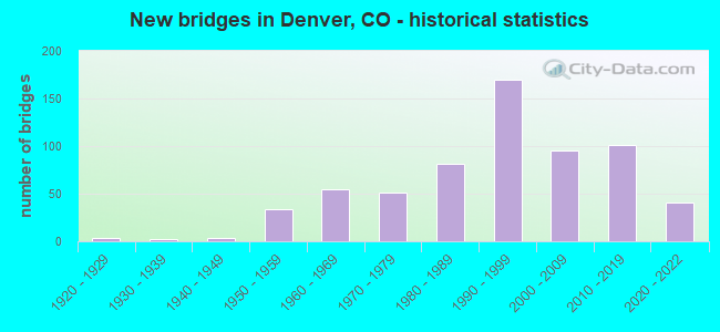
- New bridges - historical statistics
- 11910-1919
- 41920-1929
- 21930-1939
- 31940-1949
- 341950-1959
- 551960-1969
- 511970-1979
- 811980-1989
- 1701990-1999
- 952000-2009
- 1012010-2019
- 412020-2022
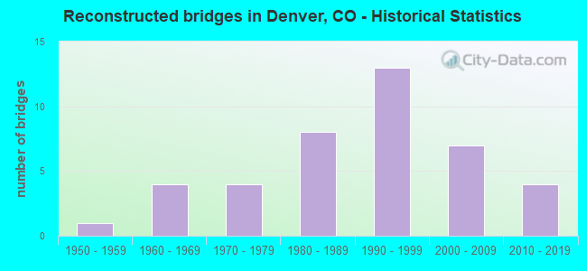
- Reconstructed bridges - Historical Statistics
- 11950-1959
- 41960-1969
- 41970-1979
- 81980-1989
- 131990-1999
- 72000-2009
- 42010-2019
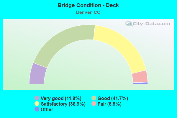
- Bridge Condition - Deck
- 11.8%Very good
- 41.7%Good
- 38.9%Satisfactory
- 6.5%Fair
- 1.0%Poor
- 0.3%Serious
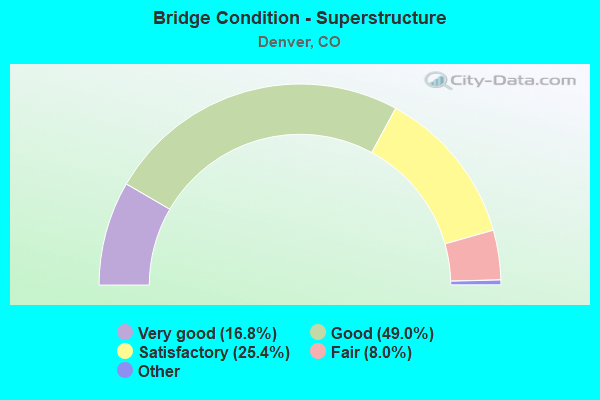
- Bridge Condition - Superstructure
- 16.8%Very good
- 49.0%Good
- 25.4%Satisfactory
- 8.0%Fair
- 0.8%Poor
- 0.3%Serious
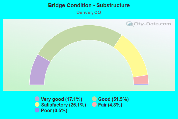
- Bridge Condition - Substructure
- 17.1%Very good
- 51.5%Good
- 26.1%Satisfactory
- 4.8%Fair
- 0.5%Poor
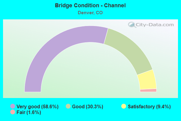
- Bridge Condition - Channel
- 58.6%Very good
- 30.3%Good
- 9.4%Satisfactory
- 1.6%Fair
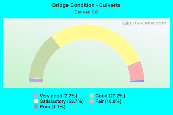
- Bridge Condition - Culverts
- 2.2%Very good
- 27.2%Good
- 58.7%Satisfactory
- 10.9%Fair
- 1.1%Poor
Find on map >> Show street view
Structure Number: F-16-IA, Location: 3.4 MI S OF JCT SH 470 (Lat: 39.527528, Lng: -105.094625), Route carried "on" structure: State highway 121B, Year Built: 1968, Status: Open, Structure Length: 0.66m (2.17ft), Average Daily Traffic: 22,000 (year 2020), Truck Traffic: 3%, Average Future Daily Traffic: 26,620 (year 2040), Design Load: HS 20, Features Intersected: BURNS DRAW, Facility Carried by Structure: SH 121 ML
Minimum Vertical Clearance: 30+ m (98+ ft), Kilometerpoint: 4.048, Lanes on structure: 4, Base Highway Network: Yes, Owner: State Highway Agency, Approaching Roadway Width: 23.9m (78.4ft), Skew: 11 degrees, Material/Design: Concrete, Design/Construction: Culvert, Number Of Spans In Main Unit: 2, Length of Maximum Span: 3.1m (10.2ft), Out-to-Out Width: 48.1m (157.8ft)
Condition: Channel: Very good, Culverts: Satisfactory, Inventory Rating: 62.8 metric tons, Method Used To Determine Inventory Rating: Load Factor (LF), Structural Evaluation: Equal to present minimum criteria, Waterway Adequacy: Equal to present desirable criteria, Approach Roadway Alignment: Equal to present desirable criteria, Designated Inspection Frequency: Every 24 months, Inspection Date: August 2021
Find on map >> Show street view
Structure Number: F-16-IL, Location: IN DENVER ON SO SANTA FE (Lat: 39.692500, Lng: -104.994400), Route carried "on" structure: US 85B, Year Built: 1972, Status: Open, Structure Length: 6.54m (21.46ft), Average Daily Traffic: 44,500 (year 2020), Truck Traffic: 8%, Average Future Daily Traffic: 56,070 (year 2040), Design Load: HS 20+Mod, Features Intersected: SOUTH PLATTE RIVER, Facility Carried by Structure: US 85 ML SBND
Minimum Vertical Clearance: 30+ m (98+ ft), Kilometerpoint: 40.110, Lanes on structure: 3, Base Highway Network: Yes, Owner: State Highway Agency, Approaching Roadway Width: 12.2m (40.0ft), Skew: 9 degrees, Material/Design: Steel continuous, Design/Construction: Stringer/Multi-beam, Number Of Spans In Main Unit: 2, Length of Maximum Span: 32.2m (105.6ft), Curb-To-Curb Width: 12.2m (40.0ft), Out-to-Out Width: 12.9m (42.3ft)
Condition: Deck: Fair, Superstructure: Satisfactory, Substructure: Satisfactory, Channel: Very good, Operating Rating: 30.8 metric tons, Method Used To Determine Operating Rating: Load Factor (LF), Inventory Rating: 18.5 metric tons, Method Used To Determine Inventory Rating: Load Factor (LF), Structural Evaluation: Meets minimum limits, Deck Geometry: High priority of corrective action, Waterway Adequacy: Equal to present desirable criteria, Approach Roadway Alignment: Better than present minimum criteria, Length Of Structure Improvement: 6.65m (21.82ft), Designated Inspection Frequency: Every 24 months, Inspection Date: September 2020, Bridge Improvement Cost: $1,000, Total Project Cost: $2,000, Deck Structure Type: Concrete Cast-file-Place, Wearing Surface/Protective System: Wearing Surface: Bituminous
Find on map >> Show street view
Structure Number: F-16-IR, Location: I25 & SPEER (Lat: 39.753600, Lng: -105.015400), Route carried "on" structure: Ramp Interstate 25A, Year Built: 2010, Status: Open, Structure Length: 3.79m (12.43ft), Average Daily Traffic: 217,000 (year 2020), Truck Traffic: 8%, Average Future Daily Traffic: 256,060 (year 2040), Design Load: HL 93, Features Intersected: SPEER ENTRANCE, Facility Carried by Structure: I25 RAMP
Minimum Vertical Clearance: 30+ m (98+ ft), Kilometerpoint: 0.270, Lanes on structure: 1, Lanes under structure: 1, Base Highway Network: Yes, Owner: State Highway Agency, Approaching Roadway Width: 7.6m (24.9ft), Skew: 6 degrees, Material/Design: Prestressed concrete, Design/Construction: Box Beam or Girders - Single/Spread, Number Of Spans In Main Unit: 1, Length of Maximum Span: 35.7m (117.1ft), Curb-To-Curb Width: 7.6m (24.9ft), Out-to-Out Width: 8.5m (27.9ft)
Condition: Deck: Good, Superstructure: Good, Substructure: Good, Operating Rating: 96.9 metric tons, Method Used To Determine Operating Rating: Load and Resistance Factor Rating (LRFR) rating reported by rating factor(RF) method using HL-93 loadings, Inventory Rating: 84.2 metric tons, Method Used To Determine Inventory Rating: Load and Resistance Factor Rating (LRFR) rating reported by rating factor(RF) method using HL-93 loadings, Structural Evaluation: Better than present minimum criteria, Deck Geometry: Better than present minimum criteria, Underclear: Meets minimum limits, Approach Roadway Alignment: Equal to present minimum criteria, Designated Inspection Frequency: Every 24 months, Inspection Date: July 2020, Deck Structure Type: Concrete Cast-file-Place, Wearing Surface/Protective System: Wearing Surface: Bituminous, Membrane: Built-up, Deck Protection: Epoxy Coated Reinforcing
Find on map >> Show street view
Structure Number: F-16-JB, Location: IN DOUGLAS COUNTY (Lat: 39.509794, Lng: -105.017394), Route carried "on" structure: County highway , Year Built: 2003, Status: Open, Structure Length: 6.54m (21.46ft), Average Daily Traffic: 9,315 (year 2021), Truck Traffic: 8%, Average Future Daily Traffic: 12,482 (year 2041), Design Load: HS 25 or greater, Features Intersected: SH 85 ML, Facility Carried by Structure: TITAN PARKWAY
Minimum Vertical Clearance: 30+ m (98+ ft), Kilometerpoint: 0.444, Lanes on structure: 2, Lanes under structure: 4, Owner: State Highway Agency, Approaching Roadway Width: 17.1m (56.1ft), Material/Design: Prestressed concrete continuous, Design/Construction: Stringer/Multi-beam, Number Of Spans In Main Unit: 2, Length of Maximum Span: 32.0m (105.0ft), Curb-To-Curb Width: 17.1m (56.1ft), Out-to-Out Width: 18.0m (59.1ft)
Condition: Deck: Good, Superstructure: Good, Substructure: Good, Operating Rating: 49.9 metric tons, Method Used To Determine Operating Rating: Load and Resistance Factor Rating (LRFR) rating reported by rating factor(RF) method using HL-93 loadings, Inventory Rating: 36.3 metric tons, Method Used To Determine Inventory Rating: Load and Resistance Factor Rating (LRFR) rating reported by rating factor(RF) method using HL-93 loadings, Structural Evaluation: Better than present minimum criteria, Deck Geometry: Superior to present desirable criteria, Underclear: Better than present minimum criteria, Approach Roadway Alignment: Equal to present desirable criteria, Designated Inspection Frequency: Every 24 months, Inspection Date: December 2021, Deck Structure Type: Concrete Precast Panels, Wearing Surface/Protective System: Wearing Surface: Bituminous, Membrane: Built-up, Deck Protection: Epoxy Coated Reinforcing
Find on map >> Show street view
Structure Number: F-16-JK, Location: IN DENVER (Lat: 39.701322, Lng: -104.987058), Route carried "on" structure: Interstate 25A, Year Built: 2002, Status: Open, Structure Length: 49.90m (163.71ft), Average Daily Traffic: 188,000 (year 2020), Truck Traffic: 6%, Average Future Daily Traffic: 227,480 (year 2040), Design Load: HL 93, Features Intersected: BRDWY,BNSF,UPRR,RTD,LR, Facility Carried by Structure: I25 ML
Minimum Vertical Clearance: 30+ m (98+ ft), Kilometerpoint: 332.811, Lanes on structure: 10, Lanes under structure: 8, Base Highway Network: Yes, Owner: State Highway Agency, Approaching Roadway Width: 52.7m (172.9ft), Skew: 39 degrees, Material/Design: Prestressed concrete continuous, Design/Construction: Box Beam or Girders - Single/Spread, Number Of Spans In Main Unit: 12, Length of Maximum Span: 46.4m (152.2ft), Curb-To-Curb Width: 51.2m (168.0ft), Out-to-Out Width: 52.7m (172.9ft)
Condition: Deck: Satisfactory, Superstructure: Good, Substructure: Good, Operating Rating: 27.2 metric tons, Method Used To Determine Operating Rating: Load and Resistance Factor Rating (LRFR) rating reported by rating factor(RF) method using HL-93 loadings, Inventory Rating: 13.0 metric tons, Method Used To Determine Inventory Rating: Load and Resistance Factor Rating (LRFR) rating reported by rating factor(RF) method using HL-93 loadings, Structural Evaluation: High priority of corrective action, Deck Geometry: Superior to present desirable criteria, Underclear: Superior to present desirable criteria, Approach Roadway Alignment: Equal to present desirable criteria, Designated Inspection Frequency: Every 24 months, Inspection Date: April 2020, Deck Structure Type: Concrete Cast-file-Place, Wearing Surface/Protective System: Wearing Surface: Bituminous, Membrane: Built-up, Deck Protection: Epoxy Coated Reinforcing
Find on map >> Show street view
Structure Number: F-16-JX, Location: COLFAX AVE AT I25 (Lat: 39.740289, Lng: -105.015931), Route carried "on" structure: US 40C, Year Built: 1984, Status: Open, Structure Length: 133.59m (438.29ft), Average Daily Traffic: 49,000 (year 2020), Truck Traffic: 3%, Average Future Daily Traffic: 54,390 (year 2040), Design Load: HS 20, Features Intersected: I25,RDWY,RR,S PLATTE RVR, Facility Carried by Structure: US 40 ML
Minimum Vertical Clearance: 30+ m (98+ ft), Kilometerpoint: 27.985, Lanes on structure: 6, Lanes under structure: 15, Base Highway Network: Yes, Owner: State Highway Agency, Approaching Roadway Width: 24.4m (80.1ft), Skew: 39 degrees, Material/Design: Prestressed concrete continuous, Design/Construction: Stringer/Multi-beam, Number Of Spans In Main Unit: 37, Length of Maximum Span: 46.0m (150.9ft), Curb or Sidewalk Widths: Left: 2.4m (7.9ft), Right: 0.0m, Curb-To-Curb Width: 24.4m (80.1ft), Out-to-Out Width: 28.7m (94.2ft)
Condition: Deck: Satisfactory, Superstructure: Satisfactory, Substructure: Satisfactory, Channel: Very good, Operating Rating: 50.7 metric tons, Method Used To Determine Operating Rating: Load Factor (LF), Inventory Rating: 30.4 metric tons, Method Used To Determine Inventory Rating: Load Factor (LF), Structural Evaluation: Equal to present minimum criteria, Deck Geometry: Somewhat better than minimum adequacy, Underclear: High priority of corrective action, Waterway Adequacy: Superior to present desirable criteria, Approach Roadway Alignment: Equal to present desirable criteria, Designated Inspection Frequency: Every 24 months, Inspection Date: December 2021, Deck Structure Type: Concrete Cast-file-Place, Wearing Surface/Protective System: Wearing Surface: Bituminous, Membrane: Preformed Fabric, Deck Protection: Epoxy Coated Reinforcing
Find on map >> Show street view
Structure Number: F-16-KT, Location: IN DENVER (Lat: 39.745681, Lng: -105.053222), Route carried "on" structure: State highway 95A, Year Built: 1982, Status: Open, Structure Length: 1.00m (3.28ft), Average Daily Traffic: 31,000 (year 2020), Truck Traffic: 3%, Average Future Daily Traffic: 33,170 (year 2040), Design Load: HS 20, Features Intersected: SLOAN LAKE DRAINAGE, Facility Carried by Structure: SH 95 ML
Minimum Vertical Clearance: 30+ m (98+ ft), Kilometerpoint: 10.429, Lanes on structure: 6, Base Highway Network: Yes, Owner: State Highway Agency, Approaching Roadway Width: 23.5m (77.1ft), Material/Design: Concrete, Design/Construction: Culvert, Number Of Spans In Main Unit: 4, Length of Maximum Span: 2.1m (6.9ft), Curb or Sidewalk Widths: Left: 2.0m (6.6ft), Right: 5.6m (18.4ft), Curb-To-Curb Width: 23.5m (77.1ft), Out-to-Out Width: 31.7m (104.0ft)
Condition: Channel: Very good, Culverts: Good, Operating Rating: 36.3 metric tons, Method Used To Determine Operating Rating: Field evaluation and documented engineering judgment, Inventory Rating: 32.7 metric tons, Method Used To Determine Inventory Rating: Field evaluation and documented engineering judgment, Structural Evaluation: Better than present minimum criteria, Deck Geometry: Somewhat better than minimum adequacy, Waterway Adequacy: Equal to present desirable criteria, Approach Roadway Alignment: Equal to present desirable criteria, Designated Inspection Frequency: Every 24 months, Inspection Date: Febuary 2020
Find on map >> Show street view
Structure Number: F-16-MX, Location: I25, US40, SH33, INTCHNG (Lat: 39.741028, Lng: -105.013072), Route carried "on" structure: Ramp Interstate 25A, Year Built: 1988, Status: Open, Structure Length: 4.11m (13.48ft), Average Daily Traffic: 117,500 (year 2020), Truck Traffic: 6%, Average Future Daily Traffic: 138,650 (year 2040), Design Load: HS 20, Features Intersected: RAMP TO I 25 NBND R, Facility Carried by Structure: RAMP TO I 25 SBND
Minimum Vertical Clearance: 30+ m (98+ ft), Kilometerpoint: 0.145, Lanes on structure: 1, Lanes under structure: 1, Base Highway Network: Yes, Owner: State Highway Agency, Approaching Roadway Width: 9.1m (29.9ft), Skew: 5 degrees, Material/Design: Prestressed concrete, Design/Construction: Box Beam or Girders - Multiple, Number Of Spans In Main Unit: 1, Length of Maximum Span: 40.0m (131.2ft), Curb-To-Curb Width: 9.1m (29.9ft), Out-to-Out Width: 10.1m (33.1ft)
Condition: Deck: Good, Superstructure: Good, Substructure: Good, Operating Rating: 57.9 metric tons, Method Used To Determine Operating Rating: Load Factor (LF), Inventory Rating: 34.7 metric tons, Method Used To Determine Inventory Rating: Load Factor (LF), Structural Evaluation: Better than present minimum criteria, Deck Geometry: Superior to present desirable criteria, Underclear: Somewhat better than minimum adequacy, Approach Roadway Alignment: Equal to present minimum criteria, Designated Inspection Frequency: Every 24 months, Inspection Date: March 2020, Deck Structure Type: Concrete Cast-file-Place, Wearing Surface/Protective System: Wearing Surface: Bituminous, Membrane: Preformed Fabric, Deck Protection: Epoxy Coated Reinforcing
Find on map >> Show street view
Structure Number: F-16-NE, Location: 0.5 MI SE OF SH470+US285 (Lat: 39.631825, Lng: -105.160664), Route carried "on" structure: City street , Year Built: 1989, Status: Open, Structure Length: 8.98m (29.46ft), Average Daily Traffic: 10,599 (year 2021), Truck Traffic: 3%, Average Future Daily Traffic: 12,189 (year 2041), Design Load: HS 20, Features Intersected: SH 470 ML, Facility Carried by Structure: QUINCY AVE
Minimum Vertical Clearance: 30+ m (98+ ft), Kilometerpoint: 1.071, Lanes on structure: 4, Lanes under structure: 7, Owner: State Highway Agency, Approaching Roadway Width: 16.5m (54.1ft), Skew: 21 degrees, Material/Design: Prestressed concrete continuous, Design/Construction: Box Beam or Girders - Multiple, Number Of Spans In Main Unit: 2, Length of Maximum Span: 46.0m (150.9ft), Curb or Sidewalk Widths: Left: 3.2m (10.5ft), Right: 1.7m (5.6ft), Curb-To-Curb Width: 16.5m (54.1ft), Out-to-Out Width: 27.2m (89.2ft)
Condition: Deck: Satisfactory, Superstructure: Satisfactory, Substructure: Satisfactory, Operating Rating: 86.4 metric tons, Method Used To Determine Operating Rating: Load Factor (LF), Inventory Rating: 51.7 metric tons, Method Used To Determine Inventory Rating: Load Factor (LF), Structural Evaluation: Equal to present minimum criteria, Deck Geometry: Meets minimum limits, Underclear: Better than present minimum criteria, Approach Roadway Alignment: Equal to present minimum criteria, Designated Inspection Frequency: Every 24 months, Inspection Date: December 2021, Deck Structure Type: Concrete Cast-file-Place, Wearing Surface/Protective System: Wearing Surface: Bituminous, Membrane: Preformed Fabric, Deck Protection: Epoxy Coated Reinforcing
Find on map >> Show street view
Structure Number: F-16-NK, Location: IN DENVER (Lat: 39.724897, Lng: -105.016069), Route carried "on" structure: Ramp Interstate 25A, Year Built: 1987, Status: Open, Structure Length: 11.03m (36.19ft), Average Daily Traffic: 215,000 (year 2020), Truck Traffic: 6%, Average Future Daily Traffic: 247,250 (year 2040), Design Load: HS 20+Mod, Features Intersected: SOUTH PLATTE RIVER R, Facility Carried by Structure: RAMP TO I 25 ML
Minimum Vertical Clearance: 30+ m (98+ ft), Kilometerpoint: 0.159, Lanes on structure: 3, Base Highway Network: Yes, Owner: State Highway Agency, Approaching Roadway Width: 16.8m (55.1ft), Skew: 9 degrees, Material/Design: Prestressed concrete continuous, Design/Construction: Box Beam or Girders - Multiple, Number Of Spans In Main Unit: 3, Length of Maximum Span: 39.3m (128.9ft), Curb-To-Curb Width: 16.6m (54.5ft), Out-to-Out Width: 17.5m (57.4ft)
Condition: Deck: Good, Superstructure: Good, Substructure: Good, Channel: Good, Operating Rating: 67.9 metric tons, Method Used To Determine Operating Rating: Load Factor (LF), Inventory Rating: 40.7 metric tons, Method Used To Determine Inventory Rating: Load Factor (LF), Structural Evaluation: Better than present minimum criteria, Deck Geometry: Superior to present desirable criteria, Waterway Adequacy: Superior to present desirable criteria, Approach Roadway Alignment: Equal to present desirable criteria, Designated Inspection Frequency: Every 24 months, Inspection Date: April 2020, Deck Structure Type: Concrete Cast-file-Place, Wearing Surface/Protective System: Wearing Surface: Bituminous, Membrane: Preformed Fabric, Deck Protection: Epoxy Coated Reinforcing
Find on map >> Show street view
Structure Number: F-16-NO, Location: JCT I-25 AT 6TH AVE IN DE (Lat: 39.726422, Lng: -105.011286), Route carried "on" structure: Ramp Interstate 25A, Year Built: 1989, Status: Open, Structure Length: 20.24m (66.40ft), Average Daily Traffic: 107,500 (year 2020), Truck Traffic: 6%, Average Future Daily Traffic: 123,625 (year 2040), Design Load: HS 20+Mod, Features Intersected: INTERCHANGE ROW R, Facility Carried by Structure: RAMP TO I 25 NBND
Minimum Vertical Clearance: 30+ m (98+ ft), Kilometerpoint: 0.159, Lanes on structure: 1, Owner: State Highway Agency, Approaching Roadway Width: 9.1m (29.9ft), Material/Design: Prestressed concrete continuous, Design/Construction: Box Beam or Girders - Multiple, Number Of Spans In Main Unit: 5, Length of Maximum Span: 45.5m (149.3ft), Curb-To-Curb Width: 9.1m (29.9ft), Out-to-Out Width: 9.1m (29.9ft)
Condition: Deck: Satisfactory, Superstructure: Satisfactory, Substructure: Satisfactory, Inventory Rating: 79.1 metric tons, Method Used To Determine Inventory Rating: Load Factor (LF), Structural Evaluation: Equal to present minimum criteria, Deck Geometry: Superior to present desirable criteria, Approach Roadway Alignment: Equal to present desirable criteria, Designated Inspection Frequency: Every 24 months, Inspection Date: April 2021, Deck Structure Type: Concrete Cast-file-Place, Wearing Surface/Protective System: Wearing Surface: Bituminous, Membrane: Preformed Fabric, Deck Protection: Epoxy Coated Reinforcing
Find on map >> Show street view
Structure Number: F-16-NW, Location: RAMP OVER I25 TO WB COLFA (Lat: 39.740656, Lng: -105.016892), Route carried "on" structure: Ramp State highway 40C, Year Built: 1987, Status: Open, Structure Length: 46.48m (152.49ft), Average Daily Traffic: 49,000 (year 2020), Truck Traffic: 3%, Average Future Daily Traffic: 54,390 (year 2040), Design Load: HS 20+Mod, Features Intersected: I25 ML,US40 ML,PLTE RVR, Facility Carried by Structure: US 40 RAMP
Minimum Vertical Clearance: 30+ m (98+ ft), Kilometerpoint: 1.510, Lanes on structure: 1, Lanes under structure: 18, Base Highway Network: Yes, Owner: State Highway Agency, Approaching Roadway Width: 6.4m (21.0ft), Skew: 9 degrees, Material/Design: Prestressed concrete continuous, Design/Construction: Stringer/Multi-beam, Number Of Spans In Main Unit: 13, Length of Maximum Span: 52.1m (170.9ft), Curb or Sidewalk Widths: Left: 2.4m (7.9ft), Right: 0.0m, Curb-To-Curb Width: 6.4m (21.0ft), Out-to-Out Width: 9.9m (32.5ft)
Condition: Deck: Good, Superstructure: Good, Substructure: Satisfactory, Channel: Very good, Operating Rating: 27.9 metric tons, Method Used To Determine Operating Rating: Load Factor (LF), Inventory Rating: 12.6 metric tons, Method Used To Determine Inventory Rating: Load Factor (LF), Structural Evaluation: High priority of corrective action, Deck Geometry: Somewhat better than minimum adequacy, Underclear: High priority of corrective action, Waterway Adequacy: Superior to present desirable criteria, Approach Roadway Alignment: Better than present minimum criteria, Designated Inspection Frequency: Every 24 months, Inspection Date: May 2020, Deck Structure Type: Concrete Cast-file-Place, Wearing Surface/Protective System: Wearing Surface: Bituminous, Membrane: Preformed Fabric, Deck Protection: Epoxy Coated Reinforcing
Find on map >> Show street view
Structure Number: F-16-NX, Location: RAMP OVER I25 TO SB I25 (Lat: 39.741003, Lng: -105.014767), Route carried "on" structure: Ramp City street , Year Built: 1987, Status: Open, Structure Length: 17.89m (58.69ft), Average Daily Traffic: 10,126 (year 2021), Truck Traffic: 7%, Average Future Daily Traffic: 11,240 (year 2041), Design Load: HS 20+Mod, Features Intersected: I25,RAMPS AND WALNUT, Facility Carried by Structure: AURARIA PKWY RAMP
Minimum Vertical Clearance: 30+ m (98+ ft), Kilometerpoint: 0.258, Lanes on structure: 2, Lanes under structure: 12, Owner: State Highway Agency, Approaching Roadway Width: 10.7m (35.1ft), Skew: 9 degrees, Material/Design: Steel continuous, Design/Construction: Stringer/Multi-beam, Number Of Spans In Main Unit: 4, Length of Maximum Span: 62.5m (205.1ft), Curb-To-Curb Width: 10.7m (35.1ft), Out-to-Out Width: 11.6m (38.1ft)
Condition: Deck: Satisfactory, Superstructure: Satisfactory, Substructure: Satisfactory, Operating Rating: 49.2 metric tons, Method Used To Determine Operating Rating: Load Factor (LF), Inventory Rating: 29.8 metric tons, Method Used To Determine Inventory Rating: Load Factor (LF), Structural Evaluation: Equal to present minimum criteria, Deck Geometry: Better than present minimum criteria, Underclear: High priority of corrective action, Approach Roadway Alignment: Better than present minimum criteria, Designated Inspection Frequency: Every 24 months, Inspection Date: May 2020, Deck Structure Type: Concrete Cast-file-Place, Wearing Surface/Protective System: Wearing Surface: Bituminous, Membrane: Preformed Fabric, Deck Protection: Epoxy Coated Reinforcing
Find on map >> Show street view
Structure Number: F-16-NY, Location: EB AURARIA PKWY (Lat: 39.741428, Lng: -105.013833), Route carried "on" structure: Ramp Interstate 25A, Year Built: 1988, Status: Open, Structure Length: 38.17m (125.23ft), Average Daily Traffic: 106,000 (year 2020), Truck Traffic: 7%, Average Future Daily Traffic: 124,020 (year 2040), Design Load: HS 20+Mod, Features Intersected: STEETS, RAMPS, RTD &, Facility Carried by Structure: I25_EB AUR. PKWY
Minimum Vertical Clearance: 30+ m (98+ ft), Kilometerpoint: 0.000, Lanes on structure: 3, Lanes under structure: 8, Base Highway Network: Yes, Owner: State Highway Agency, Approaching Roadway Width: 19.2m (63.0ft), Material/Design: Prestressed concrete continuous, Design/Construction: Box Beam or Girders - Multiple, Number Of Spans In Main Unit: 11, Length of Maximum Span: 37.6m (123.4ft), Curb-To-Curb Width: 12.2m (40.0ft), Out-to-Out Width: 13.0m (42.7ft)
Condition: Deck: Satisfactory, Superstructure: Satisfactory, Substructure: Satisfactory, Operating Rating: 53.6 metric tons, Method Used To Determine Operating Rating: Load Factor (LF), Inventory Rating: 32.2 metric tons, Method Used To Determine Inventory Rating: Load Factor (LF), Structural Evaluation: Equal to present minimum criteria, Deck Geometry: High priority of corrective action, Underclear: Meets minimum limits, Approach Roadway Alignment: Better than present minimum criteria, Length Of Structure Improvement: 38.17m (125.23ft), Designated Inspection Frequency: Every 24 months, Inspection Date: May 2020, Bridge Improvement Cost: $5,165,000, Roadway Improvement Cost: $516,000, Total Project Cost: $7,747,000, Deck Structure Type: Concrete Cast-file-Place, Wearing Surface/Protective System: Wearing Surface: Bituminous, Membrane: Preformed Fabric, Deck Protection: Epoxy Coated Reinforcing
Find on map >> Show street view
Structure Number: F-16-NZ, Location: N.W. CORNER OF I25/SH40 (Lat: 39.741536, Lng: -105.015472), Route carried "on" structure: Ramp US 40C, Year Built: 1988, Status: Open, Structure Length: 11.16m (36.61ft), Average Daily Traffic: 49,000 (year 2020), Truck Traffic: 3%, Average Future Daily Traffic: 54,390 (year 2040), Design Load: HS 20+Mod, Features Intersected: RAMP TO US 40 ML R, Facility Carried by Structure: RAMP TO US 40 ML
Minimum Vertical Clearance: 6.45m (21.16ft), Kilometerpoint: 0.187, Lanes on structure: 3, Lanes under structure: 2, Base Highway Network: Yes, Owner: State Highway Agency, Approaching Roadway Width: 13.4m (44.0ft), Material/Design: Prestressed concrete continuous, Design/Construction: Stringer/Multi-beam, Number Of Spans In Main Unit: 3, Length of Maximum Span: 36.0m (118.1ft), Curb-To-Curb Width: 13.4m (44.0ft), Out-to-Out Width: 14.3m (46.9ft)
Condition: Deck: Good, Superstructure: Good, Substructure: Good, Operating Rating: 64.2 metric tons, Method Used To Determine Operating Rating: Load Factor (LF), Inventory Rating: 38.6 metric tons, Method Used To Determine Inventory Rating: Load Factor (LF), Structural Evaluation: Better than present minimum criteria, Deck Geometry: Somewhat better than minimum adequacy, Underclear: Superior to present desirable criteria, Approach Roadway Alignment: Equal to present desirable criteria, Designated Inspection Frequency: Every 24 months, Inspection Date: November 2021, Deck Structure Type: Concrete Cast-file-Place, Wearing Surface/Protective System: Wearing Surface: Bituminous, Membrane: Preformed Fabric, Deck Protection: Epoxy Coated Reinforcing
Find on map >> Show street view
Structure Number: F-16-O, Location: IN LAKEWOOD (Lat: 39.725400, Lng: -105.081889), Route carried "on" structure: US 6G, Year Built: 1972, Status: Open, Structure Length: 5.79m (19.00ft), Average Daily Traffic: 101,000 (year 2020), Truck Traffic: 2%, Average Future Daily Traffic: 111,100 (year 2040), Design Load: HS 20, Features Intersected: SH 121 ML, Facility Carried by Structure: US 6 ML
Minimum Vertical Clearance: 30+ m (98+ ft), Kilometerpoint: 38.206, Lanes on structure: 8, Lanes under structure: 6, Base Highway Network: Yes, Owner: State Highway Agency, Approaching Roadway Width: 42.7m (140.1ft), Skew: 30 degrees, Material/Design: Concrete continuous, Design/Construction: Tee Beam, Number Of Spans In Main Unit: 4, Length of Maximum Span: 15.8m (51.8ft), Curb-To-Curb Width: 32.3m (106.0ft), Out-to-Out Width: 34.1m (111.9ft)
Condition: Deck: Serious, Superstructure: Poor, Substructure: Fair, Operating Rating: 47.2 metric tons, Method Used To Determine Operating Rating: Load Factor (LF), Inventory Rating: 28.1 metric tons, Method Used To Determine Inventory Rating: Load Factor (LF), Structural Evaluation: Meets minimum limits, Deck Geometry: Meets minimum limits, Underclear: Meets minimum limits, Approach Roadway Alignment: Equal to present desirable criteria, Length Of Structure Improvement: 5.73m (18.80ft), Designated Inspection Frequency: Every 12 months, Inspection Date: October 2021, Bridge Improvement Cost: $3,337,000, Roadway Improvement Cost: $334,000, Total Project Cost: $5,005,000, Deck Structure Type: Other, Wearing Surface/Protective System: Wearing Surface: Bituminous, Membrane: Preformed Fabric
Find on map >> Show street view
Structure Number: F-16-OB, Location: IN DENVER (Lat: 39.740094, Lng: -105.013067), Route carried "on" structure: Ramp US 40C, Year Built: 1988, Status: Open, Structure Length: 10.97m (35.99ft), Average Daily Traffic: 49,000 (year 2020), Truck Traffic: 3%, Average Future Daily Traffic: 54,390 (year 2040), Design Load: HS 20, Features Intersected: RMP TO I25 NB, Facility Carried by Structure: RMP TO I25/AUR.PKW
Minimum Vertical Clearance: 30+ m (98+ ft), Kilometerpoint: 0.082, Lanes on structure: 1, Base Highway Network: Yes, Owner: State Highway Agency, Approaching Roadway Width: 10.4m (34.1ft), Skew: 9 degrees, Material/Design: Prestressed concrete continuous, Design/Construction: Box Beam or Girders - Single/Spread, Number Of Spans In Main Unit: 3, Number Of Approach Spans: 1, Length of Maximum Span: 31.7m (104.0ft), Curb-To-Curb Width: 10.4m (34.1ft), Out-to-Out Width: 11.3m (37.1ft)
Condition: Deck: Satisfactory, Superstructure: Satisfactory, Substructure: Good, Operating Rating: 53.2 metric tons, Method Used To Determine Operating Rating: Load Factor (LF), Inventory Rating: 31.8 metric tons, Method Used To Determine Inventory Rating: Load Factor (LF), Structural Evaluation: Equal to present minimum criteria, Deck Geometry: Superior to present desirable criteria, Approach Roadway Alignment: Equal to present minimum criteria, Designated Inspection Frequency: Every 24 months, Inspection Date: April 2020, Deck Structure Type: Concrete Cast-file-Place, Wearing Surface/Protective System: Wearing Surface: Bituminous, Membrane: Preformed Fabric, Deck Protection: Epoxy Coated Reinforcing
Find on map >> Show street view
Structure Number: F-16-OD, Location: I25, US40, SH33 INTCHNG (Lat: 39.740636, Lng: -105.012453), Route carried "on" structure: Ramp Interstate 25A, Year Built: 1988, Status: Open, Structure Length: 11.06m (36.29ft), Average Daily Traffic: 235,000 (year 2020), Truck Traffic: 6%, Average Future Daily Traffic: 277,300 (year 2040), Design Load: HS 20, Features Intersected: BNSF RR R, Facility Carried by Structure: WBCOLFAX RMP/I25ML
Minimum Vertical Clearance: 30+ m (98+ ft), Kilometerpoint: 0.076, Lanes on structure: 2, Base Highway Network: Yes, Owner: State Highway Agency, Approaching Roadway Width: 9.2m (30.2ft), Skew: 2 degrees, Material/Design: Prestressed concrete continuous, Design/Construction: Box Beam or Girders - Multiple, Number Of Spans In Main Unit: 3, Length of Maximum Span: 39.6m (129.9ft), Curb-To-Curb Width: 9.2m (30.2ft), Out-to-Out Width: 10.2m (33.5ft)
Condition: Deck: Good, Superstructure: Good, Substructure: Good, Operating Rating: 66.5 metric tons, Method Used To Determine Operating Rating: Load Factor (LF), Inventory Rating: 39.9 metric tons, Method Used To Determine Inventory Rating: Load Factor (LF), Structural Evaluation: Better than present minimum criteria, Deck Geometry: Somewhat better than minimum adequacy, Underclear: Superior to present desirable criteria, Approach Roadway Alignment: Equal to present desirable criteria, Designated Inspection Frequency: Every 24 months, Inspection Date: June 2021, Deck Structure Type: Other, Wearing Surface/Protective System: Wearing Surface: Bituminous, Membrane: Preformed Fabric, Deck Protection: Epoxy Coated Reinforcing
Find on map >> Show street view
Structure Number: F-16-OE, Location: I25/US6 INTCHNG IN DENVER (Lat: 39.724367, Lng: -105.015078), Route carried "on" structure: Ramp Interstate 25A, Year Built: 1987, Status: Open, Structure Length: 16.43m (53.90ft), Average Daily Traffic: 107,500 (year 2020), Truck Traffic: 6%, Average Future Daily Traffic: 123,625 (year 2040), Design Load: HS 20, Features Intersected: RAMP TO I 25 SBND R, Facility Carried by Structure: EB6 RMP. TO I25 SB
Minimum Vertical Clearance: 30+ m (98+ ft), Kilometerpoint: 0.264, Lanes on structure: 1, Base Highway Network: Yes, Owner: State Highway Agency, Approaching Roadway Width: 12.8m (42.0ft), Material/Design: Prestressed concrete continuous, Design/Construction: Box Beam or Girders - Multiple, Number Of Spans In Main Unit: 4, Length of Maximum Span: 45.7m (149.9ft), Curb-To-Curb Width: 11.6m (38.1ft), Out-to-Out Width: 12.5m (41.0ft)
Condition: Deck: Good, Superstructure: Satisfactory, Substructure: Good, Operating Rating: 70.0 metric tons, Method Used To Determine Operating Rating: Load Factor (LF), Inventory Rating: 42.0 metric tons, Method Used To Determine Inventory Rating: Load Factor (LF), Structural Evaluation: Equal to present minimum criteria, Deck Geometry: Superior to present desirable criteria, Approach Roadway Alignment: Equal to present desirable criteria, Designated Inspection Frequency: Every 24 months, Inspection Date: June 2021, Deck Structure Type: Other, Wearing Surface/Protective System: Wearing Surface: Bituminous, Membrane: Preformed Fabric, Deck Protection: Epoxy Coated Reinforcing
Find on map >> Show street view
Structure Number: F-16-OG, Location: JCT I25 + SH6 IN DENVER (Lat: 39.724492, Lng: -105.014981), Route carried "on" structure: Ramp Interstate 25A, Year Built: 1989, Status: Open, Structure Length: 42.01m (137.83ft), Average Daily Traffic: 107,500 (year 2020), Truck Traffic: 6%, Average Future Daily Traffic: 123,625 (year 2040), Design Load: HS 20+Mod, Features Intersected: US 6 ML, Facility Carried by Structure: RAMP TO I 25 NBND
Minimum Vertical Clearance: 30+ m (98+ ft), Kilometerpoint: 0.232, Lanes on structure: 2, Lanes under structure: 16, Base Highway Network: Yes, Owner: State Highway Agency, Approaching Roadway Width: 46.0m (150.9ft), Skew: 9 degrees, Material/Design: Steel continuous, Design/Construction: Box Beam or Girders - Single/Spread, Number Of Spans In Main Unit: 12, Length of Maximum Span: 38.0m (124.7ft), Curb-To-Curb Width: 11.9m (39.0ft), Out-to-Out Width: 12.8m (42.0ft)
Condition: Deck: Good, Superstructure: Serious, Substructure: Good, Operating Rating: 69.9 metric tons, Method Used To Determine Operating Rating: Load Factor (LF), Inventory Rating: 32.7 metric tons, Method Used To Determine Inventory Rating: Load Factor (LF), Structural Evaluation: High priority of corrective action, Deck Geometry: Superior to present desirable criteria, Underclear: High priority of corrective action, Approach Roadway Alignment: Equal to present minimum criteria, Designated Inspection Frequency: Every 12 months, Critical Feature Inspection Frequency: Every 12 months, Inspection Date: May 2021, Critical Feature Inspection Date: May 2021, Deck Structure Type: Concrete Cast-file-Place, Wearing Surface/Protective System: Wearing Surface: Bituminous, Membrane: Preformed Fabric
Find on map >> Show street view
Structure Number: F-16-OH, Location: IN DENVER (Lat: 39.727386, Lng: -105.013256), Route carried "on" structure: Ramp Interstate 25A, Year Built: 1988, Status: Open, Structure Length: 19.14m (62.80ft), Average Daily Traffic: 114,000 (year 2020), Truck Traffic: 6%, Average Future Daily Traffic: 133,380 (year 2040), Features Intersected: RAMP TO 8TH AVE R, Facility Carried by Structure: 6THAVERMP TOI25 NB
Minimum Vertical Clearance: 30+ m (98+ ft), Kilometerpoint: 0.362, Lanes on structure: 2, Lanes under structure: 2, Base Highway Network: Yes, Owner: State Highway Agency, Approaching Roadway Width: 20.7m (67.9ft), Material/Design: Prestressed concrete continuous, Design/Construction: Box Beam or Girders - Multiple, Number Of Spans In Main Unit: 5, Length of Maximum Span: 46.1m (151.2ft), Curb-To-Curb Width: 14.0m (45.9ft), Out-to-Out Width: 14.9m (48.9ft)
Condition: Deck: Good, Superstructure: Good, Substructure: Satisfactory, Operating Rating: 64.1 metric tons, Method Used To Determine Operating Rating: Load Factor (LF), Inventory Rating: 38.5 metric tons, Method Used To Determine Inventory Rating: Load Factor (LF), Structural Evaluation: Equal to present minimum criteria, Deck Geometry: Superior to present desirable criteria, Underclear: Meets minimum limits, Approach Roadway Alignment: Equal to present desirable criteria, Designated Inspection Frequency: Every 24 months, Inspection Date: June 2021, Deck Structure Type: Other, Wearing Surface/Protective System: Wearing Surface: Bituminous, Membrane: Preformed Fabric, Deck Protection: Epoxy Coated Reinforcing
Find on map >> Show street view
Structure Number: F-16-OK, Location: I 25/US 6 INTCHNG IN DENV (Lat: 39.726022, Lng: -105.010267), Route carried "on" structure: Ramp Interstate 25A, Year Built: 1988, Status: Open, Structure Length: 9.46m (31.04ft), Average Daily Traffic: 215,000 (year 2020), Truck Traffic: 6%, Average Future Daily Traffic: 247,250 (year 2040), Design Load: HS 20+Mod, Features Intersected: BNSF RR R, Facility Carried by Structure: RAMP TO I 25 ML
Minimum Vertical Clearance: 30+ m (98+ ft), Kilometerpoint: 0.061, Lanes on structure: 1, Base Highway Network: Yes, Owner: State Highway Agency, Approaching Roadway Width: 9.1m (29.9ft), Material/Design: Prestressed concrete continuous, Design/Construction: Box Beam or Girders - Multiple, Number Of Spans In Main Unit: 2, Length of Maximum Span: 46.6m (152.9ft), Curb-To-Curb Width: 8.2m (26.9ft), Out-to-Out Width: 9.9m (32.5ft)
Condition: Deck: Good, Superstructure: Good, Substructure: Good, Operating Rating: 54.5 metric tons, Method Used To Determine Operating Rating: Load Factor (LF), Inventory Rating: 32.7 metric tons, Method Used To Determine Inventory Rating: Load Factor (LF), Structural Evaluation: Better than present minimum criteria, Deck Geometry: Superior to present desirable criteria, Underclear: Superior to present desirable criteria, Approach Roadway Alignment: Equal to present desirable criteria, Designated Inspection Frequency: Every 24 months, Inspection Date: April 2021, Deck Structure Type: Concrete Cast-file-Place, Wearing Surface/Protective System: Wearing Surface: Bituminous, Membrane: Preformed Fabric, Deck Protection: Epoxy Coated Reinforcing
Find on map >> Show street view
Structure Number: F-16-OL, Location: JCT I25 + SH6 IN DENVER (Lat: 39.723739, Lng: -105.012347), Route carried "on" structure: Ramp Interstate 25A, Year Built: 1989, Status: Open, Structure Length: 36.39m (119.39ft), Average Daily Traffic: 107,500 (year 2020), Truck Traffic: 6%, Average Future Daily Traffic: 123,625 (year 2040), Design Load: HS 20+Mod, Features Intersected: RAMP TO I 25 SBND, Facility Carried by Structure: 6TH AVE WB
Minimum Vertical Clearance: 30+ m (98+ ft), Kilometerpoint: 0.425, Lanes on structure: 1, Lanes under structure: 8, Base Highway Network: Yes, Owner: State Highway Agency, Approaching Roadway Width: 9.4m (30.8ft), Skew: 9 degrees, Material/Design: Steel continuous, Design/Construction: Box Beam or Girders - Single/Spread, Number Of Spans In Main Unit: 10, Length of Maximum Span: 52.6m (172.6ft), Curb-To-Curb Width: 9.4m (30.8ft), Out-to-Out Width: 10.4m (34.1ft)
Condition: Deck: Good, Superstructure: Good, Substructure: Good, Operating Rating: 77.1 metric tons, Method Used To Determine Operating Rating: Load Factor (LF), Inventory Rating: 39.0 metric tons, Method Used To Determine Inventory Rating: Load Factor (LF), Structural Evaluation: Better than present minimum criteria, Deck Geometry: Superior to present desirable criteria, Underclear: High priority of corrective action, Approach Roadway Alignment: Equal to present desirable criteria, Designated Inspection Frequency: Every 24 months, Critical Feature Inspection Frequency: Every 24 months, Inspection Date: March 2020, Critical Feature Inspection Date: March 2020, Deck Structure Type: Concrete Cast-file-Place, Wearing Surface/Protective System: Wearing Surface: Bituminous, Membrane: Built-up
Find on map >> Show street view
Structure Number: F-16-PH, Location: .5 MI S. OF BOWLES (Lat: 39.602067, Lng: -105.153472), Route carried "on" structure: State highway 470A, Year Built: 1988, Status: Open, Structure Length: 8.24m (27.03ft), Average Daily Traffic: 29,000 (year 2020), Truck Traffic: 3%, Average Future Daily Traffic: 39,150 (year 2040), Design Load: HS 20+Mod, Features Intersected: DUTCH CREEK, Facility Carried by Structure: SH 470 ML WBND
Minimum Vertical Clearance: 30+ m (98+ ft), Kilometerpoint: 13.704, Lanes on structure: 2, Base Highway Network: Yes, Owner: State Highway Agency, Approaching Roadway Width: 11.6m (38.1ft), Material/Design: Steel continuous, Design/Construction: Stringer/Multi-beam, Number Of Spans In Main Unit: 2, Length of Maximum Span: 40.8m (133.9ft), Curb-To-Curb Width: 11.6m (38.1ft), Out-to-Out Width: 12.6m (41.3ft)
Condition: Deck: Good, Superstructure: Good, Substructure: Very good, Channel: Good, Operating Rating: 70.0 metric tons, Method Used To Determine Operating Rating: Load Factor (LF), Inventory Rating: 42.0 metric tons, Method Used To Determine Inventory Rating: Load Factor (LF), Structural Evaluation: Better than present minimum criteria, Deck Geometry: Equal to present minimum criteria, Waterway Adequacy: Equal to present desirable criteria, Approach Roadway Alignment: Equal to present desirable criteria, Designated Inspection Frequency: Every 24 months, Inspection Date: August 2021, Deck Structure Type: Concrete Cast-file-Place, Wearing Surface/Protective System: Wearing Surface: Bituminous, Membrane: Preformed Fabric, Deck Protection: Epoxy Coated Reinforcing
Find on map >> Show street view
Structure Number: F-16-PL, Location: 2.06 MI N OF JCT US 285 (Lat: 39.678842, Lng: -104.993608), Route carried "on" structure: Ramp US 85B, Year Built: 1986, Status: Open, Structure Length: 14.91m (48.92ft), Average Daily Traffic: 76,000 (year 2020), Truck Traffic: 8%, Average Future Daily Traffic: 91,960 (year 2040), Design Load: HS 20, Features Intersected: RAMP TO EVANS AVE[SE] R, Facility Carried by Structure: RAMP/EVANS AVE SE
Minimum Vertical Clearance: 30+ m (98+ ft), Kilometerpoint: 0.354, Lanes on structure: 2, Owner: State Highway Agency, Approaching Roadway Width: 6.1m (20.0ft), Skew: 9 degrees, Material/Design: Prestressed concrete continuous, Design/Construction: Box Beam or Girders - Single/Spread, Number Of Spans In Main Unit: 5, Length of Maximum Span: 37.8m (124.0ft), Curb-To-Curb Width: 9.8m (32.2ft), Out-to-Out Width: 10.7m (35.1ft)
Condition: Deck: Good, Superstructure: Good, Substructure: Good, Operating Rating: 36.3 metric tons, Method Used To Determine Operating Rating: Field evaluation and documented engineering judgment, Inventory Rating: 32.7 metric tons, Method Used To Determine Inventory Rating: Field evaluation and documented engineering judgment, Structural Evaluation: Better than present minimum criteria, Deck Geometry: Equal to present minimum criteria, Approach Roadway Alignment: Equal to present desirable criteria, Designated Inspection Frequency: Every 24 months, Inspection Date: August 2020, Deck Structure Type: Concrete Cast-file-Place, Wearing Surface/Protective System: Wearing Surface: Bituminous, Membrane: Preformed Fabric, Deck Protection: Epoxy Coated Reinforcing
Find on map >> Show street view
Structure Number: F-16-PM, Location: 2.09 MI N OF JCT US 285 (Lat: 39.678592, Lng: -104.993081), Route carried "on" structure: Ramp US 85B, Year Built: 1986, Status: Open, Structure Length: 19.28m (63.25ft), Average Daily Traffic: 38,000 (year 2020), Truck Traffic: 8%, Average Future Daily Traffic: 45,980 (year 2040), Design Load: HS 20, Features Intersected: RAMP TO US 85 NBND[NE] R, Facility Carried by Structure: RAMP TO US 85 NBND
Minimum Vertical Clearance: 30+ m (98+ ft), Kilometerpoint: 0.014, Lanes on structure: 1, Base Highway Network: Yes, Owner: State Highway Agency, Approaching Roadway Width: 6.1m (20.0ft), Material/Design: Prestressed concrete continuous, Design/Construction: Box Beam or Girders - Multiple, Number Of Spans In Main Unit: 6, Length of Maximum Span: 39.0m (128.0ft), Curb-To-Curb Width: 6.1m (20.0ft), Out-to-Out Width: 7.0m (23.0ft)
Condition: Deck: Good, Superstructure: Good, Substructure: Good, Operating Rating: 36.3 metric tons, Method Used To Determine Operating Rating: Load Factor (LF), Inventory Rating: 32.7 metric tons, Method Used To Determine Inventory Rating: Load Factor (LF), Structural Evaluation: Better than present minimum criteria, Deck Geometry: Somewhat better than minimum adequacy, Approach Roadway Alignment: Equal to present desirable criteria, Designated Inspection Frequency: Every 24 months, Inspection Date: August 2020, Deck Structure Type: Concrete Cast-file-Place, Wearing Surface/Protective System: Wearing Surface: Bituminous, Membrane: Preformed Fabric, Deck Protection: Epoxy Coated Reinforcing
Find on map >> Show street view
Structure Number: F-16-PN, Location: 2.10 MI N OF JCT US 285 (Lat: 39.676983, Lng: -104.993453), Route carried "on" structure: Ramp US 85B, Year Built: 1986, Status: Open, Structure Length: 3.63m (11.91ft), Average Daily Traffic: 76,000 (year 2020), Truck Traffic: 8%, Average Future Daily Traffic: 91,960 (year 2040), Design Load: HS 20, Features Intersected: RAMP TO EVANS AVE[NW] R, Facility Carried by Structure: RAMP/EVANS AVE NW
Minimum Vertical Clearance: 30+ m (98+ ft), Kilometerpoint: 0.310, Lanes on structure: 2, Owner: State Highway Agency, Approaching Roadway Width: 11.6m (38.1ft), Skew: 9 degrees, Material/Design: Prestressed concrete continuous, Design/Construction: Box Beam or Girders - Multiple, Number Of Spans In Main Unit: 2, Length of Maximum Span: 29.0m (95.1ft), Curb-To-Curb Width: 11.7m (38.4ft), Out-to-Out Width: 12.6m (41.3ft)
Condition: Deck: Good, Superstructure: Good, Substructure: Good, Operating Rating: 89.8 metric tons, Method Used To Determine Operating Rating: Load Factor (LF), Inventory Rating: 49.2 metric tons, Method Used To Determine Inventory Rating: Load Factor (LF), Structural Evaluation: Better than present minimum criteria, Deck Geometry: Superior to present desirable criteria, Approach Roadway Alignment: Better than present minimum criteria, Designated Inspection Frequency: Every 48 months, Inspection Date: September 2020, Deck Structure Type: Concrete Cast-file-Place, Wearing Surface/Protective System: Wearing Surface: Bituminous, Membrane: Preformed Fabric, Deck Protection: Epoxy Coated Reinforcing
Find on map >> Show street view
Structure Number: F-16-PO, Location: 2.07 MI N OF JCT US 285 (Lat: 39.677972, Lng: -104.993903), Route carried "on" structure: Ramp US 85B, Year Built: 1986, Status: Open, Structure Length: 3.17m (10.40ft), Average Daily Traffic: 38,000 (year 2020), Truck Traffic: 8%, Average Future Daily Traffic: 45,980 (year 2040), Features Intersected: RAMP TO US 85 SBND[SW] R, Facility Carried by Structure: RAMP TO US 85 SBND
Minimum Vertical Clearance: 30+ m (98+ ft), Kilometerpoint: 0.060, Lanes on structure: 2, Owner: State Highway Agency, Approaching Roadway Width: 6.1m (20.0ft), Material/Design: Prestressed concrete continuous, Design/Construction: Box Beam or Girders - Multiple, Number Of Spans In Main Unit: 2, Length of Maximum Span: 24.0m (78.7ft), Curb-To-Curb Width: 13.4m (44.0ft), Out-to-Out Width: 14.4m (47.2ft)
Condition: Deck: Satisfactory, Superstructure: Satisfactory, Substructure: Satisfactory, Operating Rating: 36.3 metric tons, Method Used To Determine Operating Rating: Load Factor (LF), Inventory Rating: 32.7 metric tons, Method Used To Determine Inventory Rating: Load Factor (LF), Structural Evaluation: Equal to present minimum criteria, Deck Geometry: Superior to present desirable criteria, Approach Roadway Alignment: Equal to present desirable criteria, Designated Inspection Frequency: Every 48 months, Inspection Date: September 2020, Deck Structure Type: Concrete Cast-file-Place, Wearing Surface/Protective System: Wearing Surface: Bituminous, Membrane: Preformed Fabric, Deck Protection: Epoxy Coated Reinforcing
Find on map >> Show street view
Structure Number: F-16-QJ, Location: I25/US40 INTERCHANGE (Lat: 39.739811, Lng: -105.015061), Route carried "on" structure: Ramp Interstate 25A, Year Built: 2003, Status: Open, Structure Length: 9.94m (32.61ft), Average Daily Traffic: 117,500 (year 2020), Truck Traffic: 6%, Average Future Daily Traffic: 138,650 (year 2040), Design Load: HS 25 or greater, Features Intersected: WALNUT CONNECTOR R, Facility Carried by Structure: SBND I25 RAMP H
Minimum Vertical Clearance: 30+ m (98+ ft), Kilometerpoint: 0.192, Lanes on structure: 1, Lanes under structure: 4, Owner: State Highway Agency, Approaching Roadway Width: 9.1m (29.9ft), Material/Design: Prestressed concrete continuous, Design/Construction: Box Beam or Girders - Single/Spread, Number Of Spans In Main Unit: 2, Number Of Approach Spans: 1, Length of Maximum Span: 40.1m (131.6ft), Curb-To-Curb Width: 9.1m (29.9ft), Out-to-Out Width: 10.1m (33.1ft)
Condition: Deck: Very good, Superstructure: Very good, Substructure: Very good, Operating Rating: 72.9 metric tons, Method Used To Determine Operating Rating: Load Factor (LF), Inventory Rating: 43.7 metric tons, Method Used To Determine Inventory Rating: Load Factor (LF), Structural Evaluation: Equal to present desirable criteria, Deck Geometry: Superior to present desirable criteria, Underclear: Somewhat better than minimum adequacy, Approach Roadway Alignment: Equal to present desirable criteria, Designated Inspection Frequency: Every 24 months, Inspection Date: April 2020, Deck Structure Type: Concrete Cast-file-Place, Wearing Surface/Protective System: Wearing Surface: Bituminous, Membrane: Built-up, Deck Protection: Epoxy Coated Reinforcing
Find on map >> Show street view
Structure Number: F-16-RT, Location: HAMPDEN/SHERIDAN (Lat: 39.653428, Lng: -105.052822), Route carried "on" structure: US 285D, Year Built: 1993, Status: Open, Structure Length: 5.87m (19.26ft), Average Daily Traffic: 55,000 (year 2020), Truck Traffic: 2%, Average Future Daily Traffic: 62,700 (year 2040), Design Load: HS 20+Mod, Features Intersected: SH 95 ML, Facility Carried by Structure: US 285 ML
Minimum Vertical Clearance: 30+ m (98+ ft), Kilometerpoint: 152.170, Lanes on structure: 5, Lanes under structure: 6, Base Highway Network: Yes, Owner: State Highway Agency, Approaching Roadway Width: 34.1m (111.9ft), Material/Design: Prestressed concrete continuous, Design/Construction: Stringer/Multi-beam, Number Of Spans In Main Unit: 2, Length of Maximum Span: 29.1m (95.5ft), Curb-To-Curb Width: 36.9m (121.1ft), Out-to-Out Width: 38.4m (126.0ft)
Condition: Deck: Good, Superstructure: Good, Substructure: Good, Operating Rating: 66.3 metric tons, Method Used To Determine Operating Rating: Load Factor (LF), Inventory Rating: 39.7 metric tons, Method Used To Determine Inventory Rating: Load Factor (LF), Structural Evaluation: Better than present minimum criteria, Deck Geometry: Superior to present desirable criteria, Underclear: High priority of corrective action, Approach Roadway Alignment: Equal to present desirable criteria, Designated Inspection Frequency: Every 24 months, Inspection Date: June 2021, Deck Structure Type: Concrete Cast-file-Place, Wearing Surface/Protective System: Wearing Surface: Bituminous, Membrane: Preformed Fabric, Deck Protection: Epoxy Coated Reinforcing
Find on map >> Show street view
Structure Number: F-16-RU, Location: .2 MI E OF SHERIDAN BLVD (Lat: 39.653528, Lng: -105.048978), Route carried "on" structure: US 285D, Year Built: 1993, Status: Open, Structure Length: 7.63m (25.03ft), Average Daily Traffic: 62,000 (year 2020), Truck Traffic: 2%, Average Future Daily Traffic: 70,680 (year 2040), Design Load: HS 20+Mod, Features Intersected: BEAR CREEK, Facility Carried by Structure: US 285 ML
Minimum Vertical Clearance: 30+ m (98+ ft), Kilometerpoint: 152.503, Lanes on structure: 6, Base Highway Network: Yes, Owner: State Highway Agency, Approaching Roadway Width: 45.1m (148.0ft), Skew: 6 degrees, Material/Design: Prestressed concrete continuous, Design/Construction: Stringer/Multi-beam, Number Of Spans In Main Unit: 2, Length of Maximum Span: 36.9m (121.1ft), Curb-To-Curb Width: 39.0m (128.0ft), Out-to-Out Width: 40.9m (134.2ft)
Condition: Deck: Good, Superstructure: Good, Substructure: Satisfactory, Channel: Very good, Operating Rating: 43.1 metric tons, Method Used To Determine Operating Rating: Load Factor (LF), Inventory Rating: 21.0 metric tons, Method Used To Determine Inventory Rating: Load Factor (LF), Structural Evaluation: Somewhat better than minimum adequacy, Deck Geometry: Superior to present desirable criteria, Waterway Adequacy: Superior to present desirable criteria, Approach Roadway Alignment: Equal to present desirable criteria, Designated Inspection Frequency: Every 24 months, Inspection Date: June 2021, Deck Structure Type: Concrete Cast-file-Place, Wearing Surface/Protective System: Wearing Surface: Bituminous, Membrane: Preformed Fabric, Deck Protection: Epoxy Coated Reinforcing
Find on map >> Show street view
Structure Number: F-16-RY, Location: 0.65 MI E OF SH 95 (Lat: 39.654375, Lng: -105.041167), Route carried "on" structure: US 285D, Year Built: 1995, Status: Open, Structure Length: 2.94m (9.65ft), Average Daily Traffic: 62,000 (year 2020), Truck Traffic: 2%, Average Future Daily Traffic: 70,680 (year 2040), Design Load: HS 20, Features Intersected: RALEIGH STREET, Facility Carried by Structure: US 285 ML
Minimum Vertical Clearance: 30+ m (98+ ft), Kilometerpoint: 153.182, Lanes on structure: 6, Lanes under structure: 2, Base Highway Network: Yes, Owner: State Highway Agency, Approaching Roadway Width: 35.7m (117.1ft), Skew: 30 degrees, Material/Design: Concrete continuous, Design/Construction: Slab, Number Of Spans In Main Unit: 3, Length of Maximum Span: 12.8m (42.0ft), Curb-To-Curb Width: 34.1m (111.9ft), Out-to-Out Width: 36.0m (118.1ft)
Condition: Deck: Satisfactory, Superstructure: Satisfactory, Substructure: Good, Operating Rating: 92.1 metric tons, Method Used To Determine Operating Rating: Load Factor (LF), Inventory Rating: 55.2 metric tons, Method Used To Determine Inventory Rating: Load Factor (LF), Structural Evaluation: Equal to present minimum criteria, Deck Geometry: Superior to present desirable criteria, Underclear: Meets minimum limits, Approach Roadway Alignment: Equal to present desirable criteria, Designated Inspection Frequency: Every 24 months, Inspection Date: June 2021, Deck Structure Type: Concrete Cast-file-Place, Wearing Surface/Protective System: Wearing Surface: Bituminous, Membrane: Preformed Fabric, Deck Protection: Epoxy Coated Reinforcing
Find on map >> Show street view
Structure Number: F-16-XA, Location: IN DENVER ON SO SANTA FE (Lat: 39.702819, Lng: -104.995533), Route carried "on" structure: US 85B, Year Built: 2015, Status: Not yet open, Structure Length: 26.37m (86.52ft), Average Daily Traffic: 40,000 (year 2020), Truck Traffic: 8%, Average Future Daily Traffic: 48,000 (year 2040), Design Load: HL 93, Features Intersected: SOUTH PLATTE RIVER, Facility Carried by Structure: US 85 ML SBND
Minimum Vertical Clearance: 30+ m (98+ ft), Kilometerpoint: 41.350, Lanes on structure: 5, Base Highway Network: Yes, Owner: State Highway Agency, Approaching Roadway Width: 21.9m (71.9ft), Material/Design: Prestressed concrete continuous, Design/Construction: Box Beam or Girders - Single/Spread, Number Of Spans In Main Unit: 5, Length of Maximum Span: 57.2m (187.7ft), Curb-To-Curb Width: 21.9m (71.9ft), Out-to-Out Width: 22.9m (75.1ft)
Condition: Deck: Good, Superstructure: Good, Substructure: Good, Channel: Very good, Operating Rating: 46.3 metric tons, Method Used To Determine Operating Rating: Load and Resistance Factor Rating (LRFR) rating reported by rating factor(RF) method using HL-93 loadings, Inventory Rating: 35.0 metric tons, Method Used To Determine Inventory Rating: Load and Resistance Factor Rating (LRFR) rating reported by rating factor(RF) method using HL-93 loadings, Structural Evaluation: Better than present minimum criteria, Deck Geometry: Meets minimum limits, Waterway Adequacy: Equal to present desirable criteria, Approach Roadway Alignment: Equal to present desirable criteria, Designated Inspection Frequency: Every 24 months, Inspection Date: September 2020, Deck Structure Type: Concrete Precast Panels, Wearing Surface/Protective System: Wearing Surface: Bituminous, Membrane: Preformed Fabric, Deck Protection: Epoxy Coated Reinforcing
Find on map >> Show street view
Structure Number: F-16-XB, Location: IN DENVER (Lat: 39.742914, Lng: -105.015089), Route carried "on" structure: Interstate 25A, Year Built: 2011, Status: Open, Structure Length: 11.31m (37.11ft), Average Daily Traffic: 212,000 (year 2020), Truck Traffic: 7%, Average Future Daily Traffic: 248,040 (year 2040), Features Intersected: RDWY,RR,SOUTH PLATTE RVR, Facility Carried by Structure: I 25 ML
Minimum Vertical Clearance: 30+ m (98+ ft), Kilometerpoint: 0.591, Lanes on structure: 10, Lanes under structure: 3, Base Highway Network: Yes, Owner: State Highway Agency, Approaching Roadway Width: 58.5m (191.9ft), Skew: 33 degrees, Material/Design: Prestressed concrete continuous, Design/Construction: Box Beam or Girders - Single/Spread, Number Of Spans In Main Unit: 5, Length of Maximum Span: 38.1m (125.0ft), Curb-To-Curb Width: 58.5m (191.9ft), Out-to-Out Width: 60.0m (196.9ft)
Condition: Deck: Good, Superstructure: Good, Substructure: Good, Channel: Very good, Operating Rating: 48.9 metric tons, Method Used To Determine Operating Rating: Load Factor (LF), Inventory Rating: 35.9 metric tons, Method Used To Determine Inventory Rating: Load Factor (LF), Structural Evaluation: Better than present minimum criteria, Deck Geometry: Superior to present desirable criteria, Underclear: Equal to present minimum criteria, Waterway Adequacy: Equal to present desirable criteria, Approach Roadway Alignment: Equal to present desirable criteria, Designated Inspection Frequency: Every 24 months, Inspection Date: October 2021, Deck Structure Type: Concrete Precast Panels, Wearing Surface/Protective System: Wearing Surface: Bituminous, Membrane: Built-up, Deck Protection: Epoxy Coated Reinforcing
Find on map >> Show street view
Structure Number: F-16-XJ, Location: .3 MI S OF COLFAX (Lat: 39.734967, Lng: -105.053228), Route carried "on" structure: State highway 95A, Year Built: 2010, Status: Open, Structure Length: 8.08m (26.51ft), Average Daily Traffic: 30,000 (year 2018), Truck Traffic: 3%, Average Future Daily Traffic: 31,200 (year 2038), Design Load: HL 93, Features Intersected: Light Rail & WtrDrai, Facility Carried by Structure: SHERIDAN BLVD
Minimum Vertical Clearance: 30+ m (98+ ft), Kilometerpoint: 9.199, Lanes on structure: 4, Base Highway Network: Yes, Owner: Local Agency, Maintenance Responsibility: State Highway Agency, Approaching Roadway Width: 18.0m (59.1ft), Material/Design: Prestressed concrete, Design/Construction: Stringer/Multi-beam, Number Of Spans In Main Unit: 2, Length of Maximum Span: 41.1m (134.8ft), Curb or Sidewalk Widths: Left: 3.2m (10.5ft), Right: 3.2m (10.5ft), Curb-To-Curb Width: 21.0m (68.9ft), Out-to-Out Width: 28.3m (92.8ft)
Condition: Deck: Satisfactory, Superstructure: Satisfactory, Substructure: Good, Channel: Very good, Operating Rating: 48.6 metric tons, Method Used To Determine Operating Rating: Load and Resistance Factor Rating (LRFR) rating reported by rating factor(RF) method using HL-93 loadings, Inventory Rating: 38.9 metric tons, Method Used To Determine Inventory Rating: Load and Resistance Factor Rating (LRFR) rating reported by rating factor(RF) method using HL-93 loadings, Structural Evaluation: Equal to present minimum criteria, Deck Geometry: Superior to present desirable criteria, Underclear: High priority of corrective action, Waterway Adequacy: Equal to present desirable criteria, Approach Roadway Alignment: Equal to present desirable criteria, Designated Inspection Frequency: Every 24 months, Inspection Date: Febuary 2020, Deck Structure Type: Concrete Cast-file-Place, Wearing Surface/Protective System: Wearing Surface: Bituminous, Deck Protection: Epoxy Coated Reinforcing
Find on map >> Show street view
Structure Number: F-16-XK, Location: JUST N OF HOLDEN (Lat: 39.736736, Lng: -105.025050), Route carried "on" structure: State highway 88A, Year Built: 2011, Status: Open, Structure Length: 7.04m (23.10ft), Average Daily Traffic: 39,000 (year 2018), Truck Traffic: 5%, Average Future Daily Traffic: 38,080 (year 2031), Design Load: HL 93, Features Intersected: Light Rail, Facility Carried by Structure: SH 88-FEDERAL BLVD
Minimum Vertical Clearance: 30+ m (98+ ft), Kilometerpoint: 0.406, Lanes on structure: 6, Base Highway Network: Yes, Owner: Local Agency, Maintenance Responsibility: State Highway Agency, Approaching Roadway Width: 20.1m (65.9ft), Skew: 31 degrees, Material/Design: Prestressed concrete continuous, Design/Construction: Stringer/Multi-beam, Number Of Spans In Main Unit: 3, Length of Maximum Span: 23.0m (75.5ft), Curb or Sidewalk Widths: Left: 3.2m (10.5ft), Right: 3.2m (10.5ft), Curb-To-Curb Width: 29.0m (95.1ft), Out-to-Out Width: 36.3m (119.1ft)
Condition: Deck: Very good, Superstructure: Very good, Substructure: Very good, Channel: Very good, Operating Rating: 61.2 metric tons, Method Used To Determine Operating Rating: Load Factor (LF), Inventory Rating: 36.7 metric tons, Method Used To Determine Inventory Rating: Load Factor (LF), Structural Evaluation: Equal to present desirable criteria, Deck Geometry: Superior to present desirable criteria, Underclear: High priority of corrective action, Waterway Adequacy: Equal to present desirable criteria, Approach Roadway Alignment: Equal to present desirable criteria, Designated Inspection Frequency: Every 24 months, Inspection Date: May 2020, Deck Structure Type: Concrete Cast-file-Place, Wearing Surface/Protective System: Wearing Surface: Bituminous, Membrane: Built-up, Deck Protection: Epoxy Coated Reinforcing
Find on map >> Show street view
Structure Number: F-16-XM, Location: FEDERAL / 6 IN DENVER (Lat: 39.725278, Lng: -105.024825), Route carried "on" structure: State highway 88A, Year Built: 2014, Status: Open, Structure Length: 1.96m (6.43ft), Average Daily Traffic: 35,000 (year 2020), Truck Traffic: 5%, Average Future Daily Traffic: 36,050 (year 2040), Design Load: HL 93, Features Intersected: WB C-D ROAD, Facility Carried by Structure: SH 88-FEDERAL BLVD
Minimum Vertical Clearance: 30+ m (98+ ft), Kilometerpoint: 1.682, Lanes on structure: 9, Lanes under structure: 8, Base Highway Network: Yes, Owner: State Highway Agency, Approaching Roadway Width: 32.3m (106.0ft), Skew: 30 degrees, Material/Design: Prestressed concrete, Design/Construction: Stringer/Multi-beam, Number Of Spans In Main Unit: 1, Length of Maximum Span: 18.6m (61.0ft), Curb or Sidewalk Widths: Left: 3.4m (11.2ft), Right: 3.4m (11.2ft), Curb-To-Curb Width: 39.7m (130.2ft), Out-to-Out Width: 48.7m (159.8ft)
Condition: Deck: Good, Superstructure: Satisfactory, Substructure: Good, Operating Rating: 66.7 metric tons, Method Used To Determine Operating Rating: Load and Resistance Factor Rating (LRFR) rating reported by rating factor(RF) method using HL-93 loadings, Inventory Rating: 51.5 metric tons, Method Used To Determine Inventory Rating: Load and Resistance Factor Rating (LRFR) rating reported by rating factor(RF) method using HL-93 loadings, Structural Evaluation: Equal to present minimum criteria, Deck Geometry: Superior to present desirable criteria, Underclear: Meets minimum limits, Approach Roadway Alignment: Equal to present desirable criteria, Length Of Structure Improvement: 5.49m (18.01ft), Designated Inspection Frequency: Every 24 months, Inspection Date: November 2021, Deck Structure Type: Concrete Precast Panels, Wearing Surface/Protective System: Wearing Surface: Bituminous, Membrane: Built-up, Deck Protection: Epoxy Coated Reinforcing
Find on map >> Show street view
Structure Number: F-16-XO, Location: FEDERAL / 6 IN DENVER (Lat: 39.725664, Lng: -105.025289), Route carried "on" structure: State highway 88A, Year Built: 2014, Status: Open, Structure Length: 4.36m (14.30ft), Average Daily Traffic: 35,000 (year 2020), Truck Traffic: 5%, Average Future Daily Traffic: 36,050 (year 2040), Design Load: HL 93, Features Intersected: US 6 ML, Facility Carried by Structure: SH 88 ML FEDERAL
Minimum Vertical Clearance: 30+ m (98+ ft), Kilometerpoint: 1.637, Lanes on structure: 10, Lanes under structure: 8, Base Highway Network: Yes, Owner: State Highway Agency, Approaching Roadway Width: 42.7m (140.1ft), Material/Design: Prestressed concrete, Design/Construction: Tee Beam, Number Of Spans In Main Unit: 1, Length of Maximum Span: 41.1m (134.8ft), Curb or Sidewalk Widths: Left: 2.6m (8.5ft), Right: 2.6m (8.5ft), Curb-To-Curb Width: 36.6m (120.1ft), Out-to-Out Width: 42.7m (140.1ft)
Condition: Deck: Good, Superstructure: Good, Substructure: Good, Operating Rating: 68.0 metric tons, Method Used To Determine Operating Rating: Load and Resistance Factor Rating (LRFR) rating reported by rating factor(RF) method using HL-93 loadings, Inventory Rating: 32.4 metric tons, Method Used To Determine Inventory Rating: Load and Resistance Factor Rating (LRFR) rating reported by rating factor(RF) method using HL-93 loadings, Structural Evaluation: Better than present minimum criteria, Deck Geometry: Meets minimum limits, Underclear: Meets minimum limits, Approach Roadway Alignment: Equal to present desirable criteria, Designated Inspection Frequency: Every 24 months, Inspection Date: April 2020, Deck Structure Type: Concrete Precast Panels, Wearing Surface/Protective System: Wearing Surface: Bituminous, Membrane: Built-up, Deck Protection: Epoxy Coated Reinforcing