Bridge Statistics for Denver, Colorado (CO)
Condition, Traffic, Stress, Structural Evaluation, Project Costs
- National Bridge Inventory (NBI) Statistics
- 639Number of bridges
- 25,479ft / 7,766mTotal length
- $98,973,000Total costs
- 26,880,358Total average daily traffic
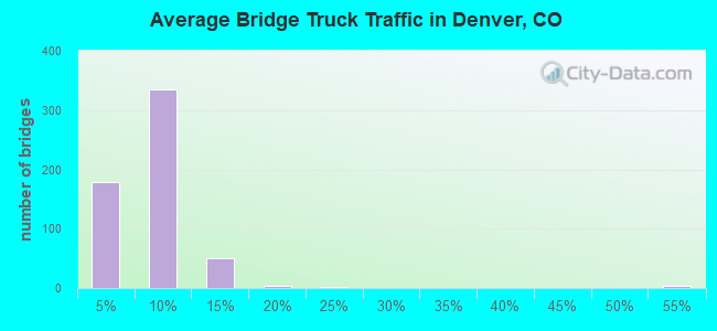
- 1,763,899Total average daily truck traffic
- National Bridge Inventory (NBI) Registered Bridges for Denver
- No street view available for this location
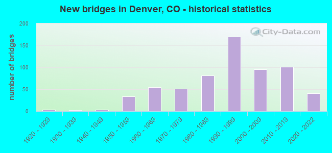
- New bridges - historical statistics
- 11910-1919
- 41920-1929
- 21930-1939
- 31940-1949
- 341950-1959
- 551960-1969
- 511970-1979
- 811980-1989
- 1701990-1999
- 952000-2009
- 1012010-2019
- 412020-2022
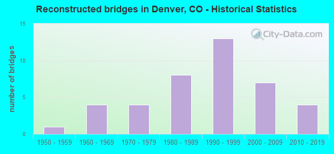
- Reconstructed bridges - Historical Statistics
- 11950-1959
- 41960-1969
- 41970-1979
- 81980-1989
- 131990-1999
- 72000-2009
- 42010-2019
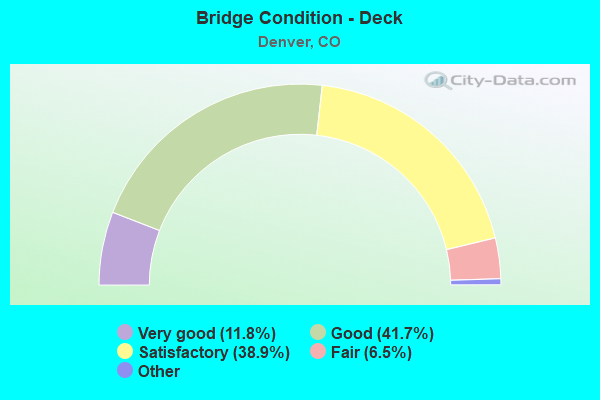
- Bridge Condition - Deck
- 11.8%Very good
- 41.7%Good
- 38.9%Satisfactory
- 6.5%Fair
- 1.0%Poor
- 0.3%Serious
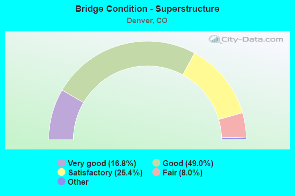
- Bridge Condition - Superstructure
- 16.8%Very good
- 49.0%Good
- 25.4%Satisfactory
- 8.0%Fair
- 0.8%Poor
- 0.3%Serious
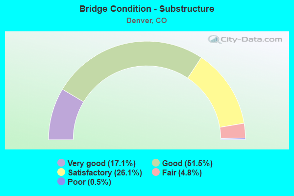
- Bridge Condition - Substructure
- 17.1%Very good
- 51.5%Good
- 26.1%Satisfactory
- 4.8%Fair
- 0.5%Poor
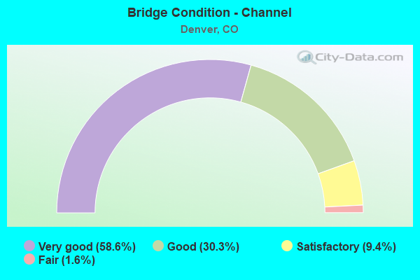
- Bridge Condition - Channel
- 58.6%Very good
- 30.3%Good
- 9.4%Satisfactory
- 1.6%Fair
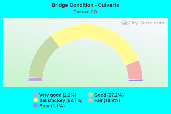
- Bridge Condition - Culverts
- 2.2%Very good
- 27.2%Good
- 58.7%Satisfactory
- 10.9%Fair
- 1.1%Poor
Find on map >> Show street view
Structure Number: E-16-GC, Location: IN DENVER (Lat: 39.780544, Lng: -104.989069), Route carried "under" structure: Ramp Interstate 70A, Year Built: 1989, Structure Length: 0. m, Average Daily Traffic: 118,600 (year 2005), Truck Traffic: 7%, Features Intersected: RAMPS TO I 25/ I 70, Facility Carried by Structure: I 25 ML
Minimum Vertical Clearance: 6.00m (19.69ft), Kilometerpoint: 441.000, Lanes on structure: 10, Lanes under structure: 4, Material/Design: Steel continuous, Design/Construction: Box Beam or Girders - Multiple, Length of Maximum Span: 36.0m (118.1ft)
Find on map >> Show street view
Structure Number: E-16-MO, Location: IN DENVER (Lat: 39.776456, Lng: -104.990083), Route carried "under" structure: Interstate 25A, Year Built: 1988, Structure Length: 0. m, Average Daily Traffic: 3,606 (year 2016), Truck Traffic: 9%, Features Intersected: I 25 ML, Facility Carried by Structure: 44TH AVE
Minimum Vertical Clearance: 5.49m (18.01ft), Kilometerpoint: 0.380, Lanes on structure: 2, Lanes under structure: 14, Material/Design: Steel continuous, Design/Construction: Box Beam or Girders - Multiple, Length of Maximum Span: 49.3m (161.7ft)
Find on map >> Show street view
Structure Number: E-16-MR, Location: AT I 25 AND I 70 (Lat: 39.781000, Lng: -104.993636), Route carried "under" structure: Ramp Interstate 25A, Year Built: 1991, Structure Length: 0. m, Average Daily Traffic: 243,300 (year 2005), Truck Traffic: 10%, Features Intersected: I 25 ML & RAMPS, Facility Carried by Structure: I 70 ML EBND
Minimum Vertical Clearance: 8.15m (26.74ft), Kilometerpoint: 343.721, Lanes on structure: 2, Lanes under structure: 16, Material/Design: Steel continuous, Design/Construction: Box Beam or Girders - Single/Spread, Length of Maximum Span: 71.9m (235.9ft)
Find on map >> Show street view
Structure Number: E-16-MS, Location: AT I 25 AND I 70 (Lat: 39.781150, Lng: -104.993567), Route carried "under" structure: Ramp Interstate 25A, Year Built: 1991, Structure Length: 0. m, Average Daily Traffic: 243,300 (year 2005), Truck Traffic: 10%, Features Intersected: I 25 ML AND RAMPS, Facility Carried by Structure: I 70 ML WBND
Minimum Vertical Clearance: 6.99m (22.93ft), Kilometerpoint: 343.723, Lanes on structure: 2, Lanes under structure: 10, Material/Design: Steel continuous, Design/Construction: Box Beam or Girders - Single/Spread, Length of Maximum Span: 71.9m (235.9ft)
Find on map >> Show street view
Structure Number: E-16-ND, Location: DENVER, OVER MOUSETRAP (Lat: 39.780094, Lng: -104.991922), Route carried "under" structure: Interstate 70A, Year Built: 1992, Structure Length: 0. m, Average Daily Traffic: 119,000 (year 2008), Truck Traffic: 7%, Features Intersected: I 25 ML, I 70 ML,RAMPS R, Facility Carried by Structure: RMP I70EB TO I25NB
Minimum Vertical Clearance: 5.44m (17.85ft), Kilometerpoint: 440.456, Lanes on structure: 1, Lanes under structure: 17, Material/Design: Steel continuous, Design/Construction: Box Beam or Girders - Single/Spread, Length of Maximum Span: 64.0m (210.0ft)
Find on map >> Show street view
Structure Number: E-16-ON, Location: IN DENVER (Lat: 39.765567, Lng: -104.995356), Route carried "under" structure: Interstate 25A, Year Built: 1998, Structure Length: 0. m, Average Daily Traffic: 3,000 (year 2018), Truck Traffic: 9%, Features Intersected: I 25 ML, RAMPS R, Facility Carried by Structure: RAMP TO PARK AVE
Minimum Vertical Clearance: 30+ m (98+ ft), Kilometerpoint: 0.901, Lanes on structure: 2, Lanes under structure: 22, Material/Design: Prestressed concrete continuous, Design/Construction: Box Beam or Girders - Single/Spread, Length of Maximum Span: 68.6m (225.1ft)
Find on map >> Show street view
Structure Number: E-16-OO, Location: 20TH STREET OVER I25 (Lat: 39.761267, Lng: -105.005314), Route carried "under" structure: Interstate 25A, Year Built: 1994, Structure Length: 0. m, Average Daily Traffic: 5,900 (year 2018), Truck Traffic: 10%, Features Intersected: I 25 ML, Facility Carried by Structure: 20TH STREET
Minimum Vertical Clearance: 6.83m (22.41ft), Kilometerpoint: 0.016, Lanes on structure: 4, Lanes under structure: 11, Material/Design: Steel continuous, Design/Construction: Box Beam or Girders - Single/Spread, Length of Maximum Span: 43.2m (141.7ft)
Find on map >> Show street view
Structure Number: E-16-OP, Location: HOV RAMP OVER I25 NBND (Lat: 39.761467, Lng: -105.002650), Route carried "under" structure: Interstate 25A, Year Built: 1993, Structure Length: 0. m, Average Daily Traffic: 2,300 (year 2018), Truck Traffic: 9%, Features Intersected: I 25 NBND R, Facility Carried by Structure: HOV RAMP
Minimum Vertical Clearance: 6.35m (20.83ft), Kilometerpoint: 0.549, Lanes on structure: 1, Lanes under structure: 9, Material/Design: Prestressed concrete continuous, Design/Construction: Box Beam or Girders - Multiple, Length of Maximum Span: 71.6m (234.9ft)
Find on map >> Show street view
Structure Number: E-16-OQ, Location: 0.75 Miles South of I-70 (Lat: 39.768928, Lng: -104.992389), Route carried "under" structure: Ramp Interstate 25A, Year Built: 1994, Structure Length: 0. m, Average Daily Traffic: 10,000 (year 2005), Truck Traffic: 10%, Features Intersected: GLOBEVILLE RMP-NB I25, Facility Carried by Structure: I70 NB RMP,.75 MI.
Minimum Vertical Clearance: 5.16m (16.93ft), Kilometerpoint: 342.717, Lanes on structure: 2, Lanes under structure: 1, Material/Design: Prestressed concrete, Design/Construction: Box Beam or Girders - Single/Spread, Length of Maximum Span: 45.7m (149.9ft)
Find on map >> Show street view
Structure Number: E-16-PJ, Location: MOUSETRAP IN DENVER (Lat: 39.781247, Lng: -104.992911), Route carried "under" structure: Ramp Interstate 70A, Year Built: 1993, Structure Length: 0. m, Average Daily Traffic: 118,600 (year 2005), Truck Traffic: 7%, Features Intersected: RAMP TO I 70 WBND R, Facility Carried by Structure: RAMP TO I 70 WBND
Minimum Vertical Clearance: 6.22m (20.41ft), Kilometerpoint: 440.451, Lanes on structure: 1, Lanes under structure: 2, Material/Design: Steel continuous, Design/Construction: Box Beam or Girders - Single/Spread, Length of Maximum Span: 66.4m (217.8ft)
Find on map >> Show street view
Structure Number: E-16-QQ, Location: IN DENVER (Lat: 39.770011, Lng: -104.992594), Route carried "under" structure: Ramp Interstate 25A, Year Built: 1996, Structure Length: 0. m, Average Daily Traffic: 3,100 (year 2018), Truck Traffic: 10%, Features Intersected: RAMP TO 38TH STREET R, Facility Carried by Structure: RAMP TO PARK AV R
Minimum Vertical Clearance: 30+ m (98+ ft), Kilometerpoint: 0.570, Lanes on structure: 2, Lanes under structure: 1, Material/Design: Concrete, Design/Construction: Frame, Length of Maximum Span: 46.0m (150.9ft)
Find on map >> Show street view
Structure Number: E-16-YA, Location: IN DENVER (Lat: 39.757292, Lng: -105.010517), Route carried "under" structure: Interstate 25A, Year Built: 2011, Structure Length: 0. m, Average Daily Traffic: 13,000 (year 2014), Truck Traffic: 10%, Features Intersected: I 25 ML, Facility Carried by Structure: 15TH STREET
Minimum Vertical Clearance: 5.72m (18.77ft), Kilometerpoint: 2.680, Lanes on structure: 4, Lanes under structure: 11, Material/Design: Steel continuous, Design/Construction: Girder and Floorbeam System, Length of Maximum Span: 37.7m (123.7ft)
Find on map >> Show street view
Structure Number: E-16-YQ, Location: IN DENVER (Lat: 39.782928, Lng: -105.006156), Route carried "under" structure: Interstate 70A, Year Built: 2013, Structure Length: 0. m, Average Daily Traffic: 10,000 (year 2018), Truck Traffic: 7%, Features Intersected: I 70 ML, Facility Carried by Structure: PECOS STREET
Minimum Vertical Clearance: 6.20m (20.34ft), Kilometerpoint: 0.024, Lanes on structure: 4, Lanes under structure: 6, Material/Design: Prestressed concrete, Design/Construction: Box Beam or Girders - Multiple, Length of Maximum Span: 47.6m (156.2ft)
Find on map >> Show street view
Structure Number: E-17-AEC, Location: I-270 TO I-70E ON RAMP (Lat: 39.776856, Lng: -104.888547), Route carried "under" structure: Ramp City street 70A, Year Built: 2012, Structure Length: 0. m, Average Daily Traffic: 800 (year 2011), Truck Traffic: 5%, Features Intersected: I70 EB RMP TO CENT PRK, Facility Carried by Structure: I270 EB RMPTOI70EB
Minimum Vertical Clearance: 5.09m (16.70ft), Kilometerpoint: 0.000, Lanes on structure: 2, Lanes under structure: 2, Material/Design: Prestressed concrete continuous, Design/Construction: Stringer/Multi-beam, Length of Maximum Span: 48.3m (158.5ft)
Find on map >> Show street view
Structure Number: E-17-AED, Location: CENT PRK RAMP TO I-70 W (Lat: 39.778150, Lng: -104.887528), Route carried "under" structure: Interstate 270A, Year Built: 2012, Structure Length: 0. m, Average Daily Traffic: 79,000 (year 2011), Truck Traffic: 12%, Features Intersected: I70 WB RMP TO I270, Facility Carried by Structure: CNTPRK RMPTOWB I70
Minimum Vertical Clearance: 5.08m (16.67ft), Kilometerpoint: 9.632, Lanes on structure: 2, Lanes under structure: 2, Material/Design: Prestressed concrete continuous, Design/Construction: Stringer/Multi-beam, Length of Maximum Span: 48.3m (158.5ft)
Find on map >> Show street view
Structure Number: E-17-AEL-2, Location: Int of I70 and Clayton (Lat: 39.780167, Lng: -104.954211), Route carried "under" structure: Interstate 70A, Year Built: 2019, Structure Length: 0. m, Average Daily Traffic: 157,000 (year 2018), Truck Traffic: 9%, Features Intersected: I 70 ML, Facility Carried by Structure: CLAYTON STREET
Minimum Vertical Clearance: 5.06m (16.60ft), Kilometerpoint: 0.000, Lanes on structure: 2, Lanes under structure: 7, Material/Design: Prestressed concrete continuous, Design/Construction: Box Beam or Girders - Multiple, Length of Maximum Span: 34.8m (114.2ft)
Find on map >> Show street view
Structure Number: E-17-AEZ, Location: IN DENVER (Lat: 39.780083, Lng: -104.958222), Route carried "under" structure: City street 70A, Year Built: 2020, Structure Length: 0. m, Average Daily Traffic: 151,000 (year 2020), Truck Traffic: 10%, Features Intersected: FUTURE I 70 ML, Facility Carried by Structure: JOSEPHINE ST.
Minimum Vertical Clearance: 5.64m (18.50ft), Kilometerpoint: 443.551, Lanes on structure: 2, Lanes under structure: 2, Material/Design: Prestressed concrete continuous, Design/Construction: Stringer/Multi-beam, Length of Maximum Span: 28.5m (93.5ft)
Find on map >> Show street view
Structure Number: E-17-AFC, Location: DENVER (Lat: 39.780361, Lng: -104.945250), Route carried "under" structure: Interstate 70A, Year Built: 2020, Structure Length: 0. m, Average Daily Traffic: 139,000 (year 2020), Truck Traffic: 9%, Features Intersected: FUTURE I 70 ML, Facility Carried by Structure: MONROE STREET
Minimum Vertical Clearance: 7.92m (25.98ft), Kilometerpoint: 446.044, Lanes on structure: 2, Lanes under structure: 6, Material/Design: Prestressed concrete continuous, Design/Construction: Stringer/Multi-beam, Length of Maximum Span: 36.1m (118.4ft)
Find on map >> Show street view
Structure Number: E-17-AFD, Location: IN DENVER (Lat: 39.779889, Lng: -104.941194), Route carried "under" structure: Interstate 70A, Year Built: 2020, Structure Length: 0. m, Average Daily Traffic: 151,000 (year 2020), Truck Traffic: 10%, Features Intersected: I70 ML, Facility Carried by Structure: SH 2 COLO. BLVD.
Minimum Vertical Clearance: 16.93m (55.54ft), Kilometerpoint: 445.106, Lanes on structure: 6, Lanes under structure: 8, Material/Design: Prestressed concrete continuous, Design/Construction: Stringer/Multi-beam, Length of Maximum Span: 34.2m (112.2ft)
Find on map >> Show street view
Structure Number: E-17-AFF, Location: DENVER (Lat: 39.780194, Lng: -104.931806), Route carried "under" structure: City street , Year Built: 2020, Structure Length: 0. m, Features Intersected: DAHLIA STREET, Facility Carried by Structure: I 70 ML WBND
Minimum Vertical Clearance: 5.12m (16.80ft), Kilometerpoint: 0.000, Lanes on structure: 4, Lanes under structure: 4, Material/Design: Prestressed concrete, Design/Construction: Stringer/Multi-beam, Length of Maximum Span: 26.2m (86.0ft)
Find on map >> Show street view
Structure Number: E-17-AFG, Location: DENVER (Lat: 39.780056, Lng: -104.931667), Route carried "under" structure: City street , Year Built: 2020, Structure Length: 0. m, Features Intersected: DAHLIA STREET, Facility Carried by Structure: I 70 ML EBND
Minimum Vertical Clearance: 5.09m (16.70ft), Kilometerpoint: 0.000, Lanes on structure: 4, Lanes under structure: 4, Material/Design: Prestressed concrete, Design/Construction: Stringer/Multi-beam, Length of Maximum Span: 26.2m (86.0ft)
Find on map >> Show street view
Structure Number: E-17-AFH, Location: DENVER (Lat: 39.778556, Lng: -104.922472), Route carried "under" structure: City street , Year Built: 2020, Structure Length: 0. m, Features Intersected: HOLLY STREET, Facility Carried by Structure: I70 ML WBND
Minimum Vertical Clearance: 5.12m (16.80ft), Kilometerpoint: 0.000, Lanes on structure: 3, Lanes under structure: 6, Material/Design: Prestressed concrete, Design/Construction: Stringer/Multi-beam, Length of Maximum Span: 32.6m (107.0ft)
Find on map >> Show street view
Structure Number: E-17-AFI, Location: DENVER (Lat: 39.778417, Lng: -104.922472), Route carried "under" structure: City street , Year Built: 2020, Structure Length: 0. m, Features Intersected: HOLLY STREET, Facility Carried by Structure: I 70 ML EBND
Minimum Vertical Clearance: 5.12m (16.80ft), Kilometerpoint: 0.000, Lanes on structure: 3, Lanes under structure: 6, Material/Design: Prestressed concrete, Design/Construction: Stringer/Multi-beam, Length of Maximum Span: 32.6m (107.0ft)
Find on map >> Show street view
Structure Number: E-17-AFJ, Location: DENVER (Lat: 39.778417, Lng: -104.912889), Route carried "under" structure: City street , Year Built: 2020, Structure Length: 0. m, Features Intersected: MONACO STREET, Facility Carried by Structure: I70 ML WBND
Minimum Vertical Clearance: 5.06m (16.60ft), Kilometerpoint: 447.454, Lanes on structure: 4, Lanes under structure: 4, Material/Design: Prestressed concrete, Design/Construction: Stringer/Multi-beam, Length of Maximum Span: 30.2m (99.1ft)
Find on map >> Show street view
Structure Number: E-17-AFK, Location: DENVER (Lat: 39.778306, Lng: -104.912861), Route carried "under" structure: City street , Year Built: 2020, Structure Length: 0. m, Features Intersected: MONACO STREET, Facility Carried by Structure: I70 ML EBND
Minimum Vertical Clearance: 5.06m (16.60ft), Kilometerpoint: 447.454, Lanes on structure: 4, Lanes under structure: 4, Material/Design: Prestressed concrete, Design/Construction: Stringer/Multi-beam, Length of Maximum Span: 30.2m (99.1ft)
Find on map >> Show street view
Structure Number: E-17-AFQ, Location: DENVER (Lat: 39.778619, Lng: -104.903817), Route carried "under" structure: City street 35A, Year Built: 2020, Structure Length: 0. m, Average Daily Traffic: 52,000 (year 2020), Truck Traffic: 10%, Features Intersected: SH 35 ML, Facility Carried by Structure: I 70 ML WBND
Minimum Vertical Clearance: 5.15m (16.90ft), Kilometerpoint: 0.000, Lanes on structure: 3, Lanes under structure: 6, Material/Design: Prestressed concrete, Design/Construction: Stringer/Multi-beam, Length of Maximum Span: 48.2m (158.1ft)
Find on map >> Show street view
Structure Number: E-17-AFR, Location: DENVER (Lat: 39.778125, Lng: -104.903819), Route carried "under" structure: City street 35A, Year Built: 2020, Structure Length: 0. m, Average Daily Traffic: 52,000 (year 2020), Truck Traffic: 10%, Features Intersected: SH 35 ML, Facility Carried by Structure: I 70 ML EBND
Minimum Vertical Clearance: 5.15m (16.90ft), Kilometerpoint: 0.000, Lanes on structure: 3, Lanes under structure: 6, Material/Design: Prestressed concrete, Design/Construction: Stringer/Multi-beam, Length of Maximum Span: 48.2m (158.1ft)
Find on map >> Show street view
Structure Number: E-17-AFS, Location: DENVER (Lat: 39.778750, Lng: -104.897556), Route carried "under" structure: Interstate 70A, Year Built: 2019, Structure Length: 0. m, Average Daily Traffic: 136,000 (year 2020), Truck Traffic: 9%, Features Intersected: I 70 ML, Facility Carried by Structure: I 270 ML EBND
Minimum Vertical Clearance: 7.11m (23.33ft), Kilometerpoint: 448.846, Lanes on structure: 2, Lanes under structure: 8, Material/Design: Steel continuous, Design/Construction: Stringer/Multi-beam, Length of Maximum Span: 64.8m (212.6ft)
Find on map >> Show street view
Structure Number: E-17-AFT, Location: IN DENVER (Lat: 39.774222, Lng: -104.847344), Route carried "under" structure: City street , Year Built: 2020, Structure Length: 0. m, Features Intersected: PEORIA STREET, Facility Carried by Structure: I 70 ML WBND
Minimum Vertical Clearance: 5.16m (16.93ft), Kilometerpoint: 0.000, Lanes on structure: 6, Lanes under structure: 3, Material/Design: Prestressed concrete continuous, Design/Construction: Stringer/Multi-beam, Length of Maximum Span: 25.2m (82.7ft)
Find on map >> Show street view
Structure Number: E-17-AFU, Location: IN DENVER (Lat: 39.774056, Lng: -104.847344), Route carried "under" structure: City street , Year Built: 2020, Structure Length: 0. m, Features Intersected: PEORIA STREET, Facility Carried by Structure: I 70 ML EBND
Minimum Vertical Clearance: 5.05m (16.57ft), Kilometerpoint: 0.000, Lanes on structure: 5, Lanes under structure: 3, Material/Design: Prestressed concrete continuous, Design/Construction: Stringer/Multi-beam, Length of Maximum Span: 25.2m (82.7ft)
Find on map >> Show street view
Structure Number: E-17-NB, Location: 0.6 MI W OF JCT I 25 (Lat: 39.827394, Lng: -104.987636), Route carried "under" structure: State highway 224A, Year Built: 1986, Structure Length: 0. m, Average Daily Traffic: 15,000 (year 2011), Truck Traffic: 4%, Features Intersected: SH 224 ML/BRDWY., Facility Carried by Structure: US 36 ML
Minimum Vertical Clearance: 5.08m (16.67ft), Kilometerpoint: 0.032, Lanes on structure: 8, Lanes under structure: 4, Material/Design: Steel continuous, Design/Construction: Stringer/Multi-beam, Length of Maximum Span: 14.6m (47.9ft)
Find on map >> Show street view
Structure Number: E-17-PB, Location: IN DENVER(MOUSETRAP) (Lat: 39.780547, Lng: -104.988053), Route carried "under" structure: Ramp Interstate 25A, Year Built: 1993, Structure Length: 0. m, Average Daily Traffic: 19,920 (year 2005), Truck Traffic: 13%, Features Intersected: RAMP TO I-25 SBND R, Facility Carried by Structure: RMP/I25NB TO I70WB
Minimum Vertical Clearance: 10.00m (32.81ft), Kilometerpoint: 344.000, Lanes on structure: 1, Lanes under structure: 2, Material/Design: Steel continuous, Design/Construction: Box Beam or Girders - Single/Spread, Length of Maximum Span: 50.3m (165.0ft)
Find on map >> Show street view
Structure Number: E-17-PC, Location: MOUSETRAP IN DENVER (Lat: 39.781150, Lng: -104.991242), Route carried "under" structure: Ramp Interstate 70A, Year Built: 1993, Structure Length: 0. m, Average Daily Traffic: 118,600 (year 2005), Truck Traffic: 7%, Features Intersected: RAMP TO I 70 WBND R, Facility Carried by Structure: RAMP TO I 70 EBND
Minimum Vertical Clearance: 10.00m (32.81ft), Kilometerpoint: 441.000, Lanes on structure: 1, Lanes under structure: 3, Material/Design: Steel continuous, Design/Construction: Box Beam or Girders - Single/Spread, Length of Maximum Span: 50.3m (165.0ft)
Find on map >> Show street view
Structure Number: E-17-PD, Location: IN DENVER (Lat: 39.779025, Lng: -104.990189), Route carried "under" structure: Ramp Interstate 25A, Year Built: 1993, Structure Length: 0. m, Average Daily Traffic: 243,300 (year 2005), Truck Traffic: 10%, Features Intersected: I 25 ML, RAMPS R, Facility Carried by Structure: RAMP TO I 70 EBND
Minimum Vertical Clearance: 8.00m (26.25ft), Kilometerpoint: 344.000, Lanes on structure: 2, Lanes under structure: 8, Material/Design: Steel continuous, Design/Construction: Box Beam or Girders - Single/Spread, Length of Maximum Span: 62.8m (206.0ft)
Find on map >> Show street view
Structure Number: E-17-QB, Location: NE OF JCT I25 (Lat: 39.823739, Lng: -104.962236), Route carried "under" structure: Ramp Interstate 76A, Year Built: 2003, Structure Length: 0. m, Average Daily Traffic: 41,600 (year 2005), Truck Traffic: 17%, Features Intersected: I76 WB ON RAMP FROM I270, Facility Carried by Structure: I76 EB ML
Minimum Vertical Clearance: 5.50m (18.04ft), Kilometerpoint: 11.172, Lanes on structure: 3, Lanes under structure: 1, Material/Design: Prestressed concrete, Design/Construction: Box Beam or Girders - Single/Spread, Length of Maximum Span: 44.5m (146.0ft)
Find on map >> Show street view
Structure Number: E-17-QI, Location: I25/US36 HOV PHASE II (Lat: 39.826164, Lng: -104.969447), Route carried "under" structure: Ramp Interstate 76A, Year Built: 1999, Structure Length: 0. m, Average Daily Traffic: 10,000 (year 2005), Truck Traffic: 11%, Features Intersected: I76 RAMP,SH224,CLEAR CRK, Facility Carried by Structure: I 270 EBND
Minimum Vertical Clearance: 6.71m (22.01ft), Kilometerpoint: 10.945, Lanes on structure: 2, Lanes under structure: 1, Material/Design: Prestressed concrete continuous, Design/Construction: Stringer/Multi-beam, Length of Maximum Span: 46.9m (153.9ft)
Find on map >> Show street view
Structure Number: E-17-QI, Location: I25/US36 HOV PHASE II (Lat: 39.826164, Lng: -104.969447), Route carried "under" structure: State highway 224A, Year Built: 1999, Structure Length: 0. m, Average Daily Traffic: 14,700 (year 2005), Truck Traffic: 6%, Features Intersected: I76 RAMP,SH224,CLEAR CRK, Facility Carried by Structure: I 270 EBND
Minimum Vertical Clearance: 6.71m (22.01ft), Kilometerpoint: 2.416, Lanes on structure: 2, Lanes under structure: 2, Material/Design: Prestressed concrete continuous, Design/Construction: Stringer/Multi-beam, Length of Maximum Span: 46.9m (153.9ft)
Find on map >> Show street view
Structure Number: E-17-QK, Location: SH 270 and I76 (Lat: 39.826117, Lng: -104.969689), Route carried "under" structure: Ramp Interstate 270A, Year Built: 2010, Structure Length: 0. m, Average Daily Traffic: 7,280 (year 2005), Truck Traffic: 15%, Features Intersected: I76,RMPS,SH224,CLR.CRK., Facility Carried by Structure: 270SB _76EB RMP Y
Minimum Vertical Clearance: 5.06m (16.60ft), Kilometerpoint: 0.008, Lanes on structure: 1, Lanes under structure: 1, Material/Design: Prestressed concrete continuous, Design/Construction: Box Beam or Girders - Single/Spread, Length of Maximum Span: 70.1m (230.0ft)
Find on map >> Show street view
Structure Number: E-17-QK, Location: SH 270 and I76 (Lat: 39.826117, Lng: -104.969689), Route carried "under" structure: Ramp Interstate 76A, Year Built: 2010, Structure Length: 0. m, Average Daily Traffic: 90,803 (year 2005), Truck Traffic: 11%, Features Intersected: I76,RMPS,SH224,CLR.CRK., Facility Carried by Structure: 270SB _76EB RMP Y
Minimum Vertical Clearance: 5.06m (16.60ft), Kilometerpoint: 10.960, Lanes on structure: 1, Lanes under structure: 1, Material/Design: Prestressed concrete continuous, Design/Construction: Box Beam or Girders - Single/Spread, Length of Maximum Span: 70.1m (230.0ft)
Find on map >> Show street view
Structure Number: E-17-QK, Location: SH 270 and I76 (Lat: 39.826117, Lng: -104.969689), Route carried "under" structure: Ramp Interstate 76A, Year Built: 2010, Structure Length: 0. m, Average Daily Traffic: 9,080 (year 2005), Truck Traffic: 11%, Features Intersected: I76,RMPS,SH224,CLR.CRK., Facility Carried by Structure: 270SB _76EB RMP Y
Minimum Vertical Clearance: 5.06m (16.60ft), Kilometerpoint: 10.960, Lanes on structure: 1, Lanes under structure: 1, Material/Design: Prestressed concrete continuous, Design/Construction: Box Beam or Girders - Single/Spread, Length of Maximum Span: 70.1m (230.0ft)
Find on map >> Show street view
Structure Number: E-17-QK, Location: SH 270 and I76 (Lat: 39.826117, Lng: -104.969689), Route carried "under" structure: State highway 224A, Year Built: 2010, Structure Length: 0. m, Average Daily Traffic: 11,700 (year 2008), Truck Traffic: 6%, Features Intersected: I76,RMPS,SH224,CLR.CRK., Facility Carried by Structure: 270SB _76EB RMP Y
Minimum Vertical Clearance: 5.06m (16.60ft), Kilometerpoint: 1.215, Lanes on structure: 1, Material/Design: Prestressed concrete continuous, Design/Construction: Box Beam or Girders - Single/Spread, Length of Maximum Span: 70.1m (230.0ft)
Find on map >> Show street view
Structure Number: E-17-QK, Location: SH 270 and I76 (Lat: 39.826117, Lng: -104.969689), Route carried "under" structure: Interstate 76A, Year Built: 2010, Structure Length: 0. m, Average Daily Traffic: 46,900 (year 2008), Truck Traffic: 11%, Features Intersected: I76,RMPS,SH224,CLR.CRK., Facility Carried by Structure: 270SB _76EB RMP Y
Minimum Vertical Clearance: 5.03m (16.50ft), Kilometerpoint: 11.133, Lanes on structure: 1, Lanes under structure: 7, Material/Design: Prestressed concrete continuous, Design/Construction: Box Beam or Girders - Single/Spread, Length of Maximum Span: 70.1m (230.0ft)
Find on map >> Show street view
Structure Number: E-17-QP, Location: I25/US36 HOV PHASE II (Lat: 39.826333, Lng: -104.969031), Route carried "under" structure: Ramp Interstate 76A, Year Built: 1998, Structure Length: 0. m, Average Daily Traffic: 10,000 (year 2005), Truck Traffic: 11%, Features Intersected: I76 RAMP,SH224,CLEAR CRK, Facility Carried by Structure: I270 WBND ML
Minimum Vertical Clearance: 7.01m (23.00ft), Kilometerpoint: 10.947, Lanes on structure: 4, Lanes under structure: 1, Material/Design: Prestressed concrete continuous, Design/Construction: Stringer/Multi-beam, Length of Maximum Span: 49.0m (160.8ft)
Find on map >> Show street view
Structure Number: E-17-QP, Location: I25/US36 HOV PHASE II (Lat: 39.826333, Lng: -104.969031), Route carried "under" structure: State highway 224A, Year Built: 1998, Structure Length: 0. m, Average Daily Traffic: 11,700 (year 2008), Truck Traffic: 6%, Features Intersected: I76 RAMP,SH224,CLEAR CRK, Facility Carried by Structure: I270 WBND ML
Minimum Vertical Clearance: 32.01m (105.02ft), Kilometerpoint: 2.414, Lanes on structure: 4, Lanes under structure: 2, Material/Design: Prestressed concrete continuous, Design/Construction: Stringer/Multi-beam, Length of Maximum Span: 49.0m (160.8ft)
Find on map >> Show street view
Structure Number: E-17-SW, Location: DENVER (Lat: 39.769006, Lng: -104.828250), Route carried "under" structure: Interstate 225A, Year Built: 1994, Structure Length: 0. m, Average Daily Traffic: 50,000 (year 0000), Truck Traffic: 10%, Features Intersected: I 70 ML, Facility Carried by Structure: I 225 ML SBND
Minimum Vertical Clearance: 5.06m (16.60ft), Kilometerpoint: 19.434, Lanes on structure: 2, Lanes under structure: 5, Material/Design: Steel continuous, Design/Construction: Box Beam or Girders - Single/Spread, Length of Maximum Span: 85.3m (279.9ft)
Find on map >> Show street view
Structure Number: E-17-SW, Location: DENVER (Lat: 39.769006, Lng: -104.828250), Route carried "under" structure: Interstate 70A, Year Built: 1994, Structure Length: 0. m, Average Daily Traffic: 150,000 (year 2008), Truck Traffic: 8%, Features Intersected: I 70 ML, Facility Carried by Structure: I 225 ML SBND
Minimum Vertical Clearance: 10.37m (34.02ft), Kilometerpoint: 454.671, Lanes on structure: 2, Lanes under structure: 5, Material/Design: Steel continuous, Design/Construction: Box Beam or Girders - Single/Spread, Length of Maximum Span: 85.3m (279.9ft)
Find on map >> Show street view
Structure Number: E-17-UT, Location: DENVER (Lat: 39.771742, Lng: -104.828550), Route carried "under" structure: Interstate 70A, Year Built: 1997, Structure Length: 0. m, Average Daily Traffic: 146,300 (year 2005), Truck Traffic: 8%, Features Intersected: I 70 ML, Facility Carried by Structure: I 225 NB RAMP
Minimum Vertical Clearance: 30+ m (98+ ft), Kilometerpoint: 454.669, Lanes on structure: 3, Lanes under structure: 6, Material/Design: Prestressed concrete continuous, Design/Construction: Box Beam or Girders - Multiple, Length of Maximum Span: 90.3m (296.3ft)
Find on map >> Show street view
Structure Number: E-17-VD, Location: IN DENVER (Lat: 39.776056, Lng: -105.452042), Route carried "under" structure: City street , Year Built: 2016, Structure Length: 0. m, Features Intersected: HAVANA ST, UP RR, Facility Carried by Structure: I 70 ML
Minimum Vertical Clearance: 5.44m (17.85ft), Kilometerpoint: 0.000, Lanes on structure: 11, Lanes under structure: 5, Material/Design: Prestressed concrete continuous, Design/Construction: Box Beam or Girders - Multiple, Length of Maximum Span: 26.4m (86.6ft)
Find on map >> Show street view
Structure Number: E-17-VE, Location: .04 MI W of HAVANA (Lat: 39.776111, Lng: -104.866833), Route carried "under" structure: Other road , Year Built: 2017, Structure Length: 0. m, Features Intersected: FUTURE UP RR, Facility Carried by Structure: I 70 ML
Minimum Vertical Clearance: 16.76m (54.99ft), Kilometerpoint: 0.000, Lanes on structure: 11, Material/Design: Concrete, Design/Construction: Slab, Length of Maximum Span: 12.2m (40.0ft)
Find on map >> Show street view
Structure Number: E-470-27.86A, Location: 27.86 MI FROM I25 (Lat: 39.833444, Lng: -104.746750), Route carried "under" structure: Other road PENA, Year Built: 1996, Structure Length: 0. m, Average Daily Traffic: 20,000 (year 2000), Truck Traffic: 6%, Features Intersected: Pena Boulevard, Facility Carried by Structure: E-470 NB
Minimum Vertical Clearance: 5.85m (19.19ft), Kilometerpoint: 0.000, Lanes on structure: 3, Lanes under structure: 7, Toll: On toll road, Material/Design: Prestressed concrete continuous, Design/Construction: Stringer/Multi-beam, Length of Maximum Span: 45.8m (150.3ft)
Find on map >> Show street view
Structure Number: E-470-27.86B, Location: 27.86 MI FROM I25 (Lat: 39.833472, Lng: -104.747083), Route carried "under" structure: Other road PENA, Year Built: 1996, Structure Length: 0. m, Average Daily Traffic: 20,000 (year 2000), Truck Traffic: 6%, Features Intersected: Pena Boulevard, Facility Carried by Structure: E-470 SB
Minimum Vertical Clearance: 5.88m (19.29ft), Kilometerpoint: 0.000, Lanes on structure: 4, Lanes under structure: 7, Toll: On toll road, Material/Design: Prestressed concrete continuous, Design/Construction: Stringer/Multi-beam, Length of Maximum Span: 45.2m (148.3ft)
Find on map >> Show street view
Structure Number: F-16-AZ, Location: N SIDE OF I-25 INT DEN. (Lat: 39.726100, Lng: -105.013983), Route carried "under" structure: Interstate 25A, Year Built: 2014, Structure Length: 0. m, Features Intersected: I 25 ML, Facility Carried by Structure: US 6 RAMP B
Minimum Vertical Clearance: 5.03m (16.50ft), Kilometerpoint: 0.206, Lanes on structure: 1, Lanes under structure: 9, Material/Design: Prestressed concrete continuous, Design/Construction: Stringer/Multi-beam, Length of Maximum Span: 25.9m (85.0ft)
Find on map >> Show street view
Structure Number: F-16-DA, Location: IN DENVER (Lat: 39.751222, Lng: -105.016992), Route carried "under" structure: Interstate 25A, Year Built: 1952, Structure Length: 0. m, Average Daily Traffic: 9,716 (year 2016), Truck Traffic: 8%, Features Intersected: I 25 ML, Facility Carried by Structure: 23RD AVENUE
Minimum Vertical Clearance: 5.18m (16.99ft), Kilometerpoint: 0.161, Lanes on structure: 2, Lanes under structure: 8, Material/Design: Concrete continuous, Design/Construction: Frame, Length of Maximum Span: 23.8m (78.1ft)
Find on map >> Show street view
Structure Number: F-16-DQ, Location: I25, SH33, US 40 INTERCHA (Lat: 39.741850, Lng: -105.014361), Route carried "under" structure: Ramp Interstate 25A, Year Built: 1952, Structure Length: 0. m, Average Daily Traffic: 206,300 (year 2005), Truck Traffic: 7%, Features Intersected: RAMP TO I25 SB WALNUT ST, Facility Carried by Structure: I 25 ML
Minimum Vertical Clearance: 5.31m (17.42ft), Kilometerpoint: 338.629, Lanes on structure: 8, Lanes under structure: 3, Material/Design: Concrete, Design/Construction: Frame, Length of Maximum Span: 18.0m (59.1ft)
Find on map >> Show street view
Structure Number: F-16-EV, Location: IN DENVER (Lat: 39.725272, Lng: -105.032378), Route carried "under" structure: US 6G, Year Built: 2014, Structure Length: 0. m, Average Daily Traffic: 4,900 (year 2014), Truck Traffic: 3%, Features Intersected: US 6 ML, Facility Carried by Structure: KNOX CT
Minimum Vertical Clearance: 5.03m (16.50ft), Kilometerpoint: 0.970, Lanes on structure: 3, Lanes under structure: 8, Material/Design: Prestressed concrete continuous, Design/Construction: Box Beam or Girders - Multiple, Length of Maximum Span: 23.6m (77.4ft)
Find on map >> Show street view
Structure Number: F-16-GG, Location: IN DENVER (Lat: 39.725528, Lng: -105.039383), Route carried "under" structure: US 6G, Year Built: 1964, Structure Length: 0. m, Average Daily Traffic: 133,000 (year 2018), Truck Traffic: 4%, Features Intersected: US 6 ML, Facility Carried by Structure: PERRY STREET
Minimum Vertical Clearance: 4.95m (16.24ft), Kilometerpoint: 0.604, Lanes on structure: 2, Lanes under structure: 6, Material/Design: Steel, Design/Construction: Stringer/Multi-beam, Length of Maximum Span: 26.7m (87.6ft)
Find on map >> Show street view
Structure Number: F-16-JX, Location: COLFAX AVE AT I25 (Lat: 39.740289, Lng: -105.015931), Route carried "under" structure: Interstate 25A, Year Built: 1984, Structure Length: 0. m, Average Daily Traffic: 249,000 (year 2011), Truck Traffic: 6%, Features Intersected: I25,RDWY,RR,S PLATTE RVR, Facility Carried by Structure: US 40 ML
Minimum Vertical Clearance: 30+ m (98+ ft), Kilometerpoint: 338.388, Lanes on structure: 6, Lanes under structure: 8, Material/Design: Prestressed concrete continuous, Design/Construction: Stringer/Multi-beam, Length of Maximum Span: 46.0m (150.9ft)
Find on map >> Show street view
Structure Number: F-16-NW, Location: RAMP OVER I25 TO WB COLFA (Lat: 39.740656, Lng: -105.016892), Route carried "under" structure: Interstate 25A, Year Built: 1987, Structure Length: 0. m, Average Daily Traffic: 26,000 (year 2014), Truck Traffic: 8%, Features Intersected: I25 ML,US40 ML,PLTE RVR, Facility Carried by Structure: US 40 RAMP
Minimum Vertical Clearance: 6.00m (19.69ft), Kilometerpoint: 1.510, Lanes on structure: 1, Lanes under structure: 6, Material/Design: Prestressed concrete continuous, Design/Construction: Stringer/Multi-beam, Length of Maximum Span: 52.1m (170.9ft)
Find on map >> Show street view
Structure Number: F-16-NW, Location: RAMP OVER I25 TO WB COLFA (Lat: 39.740656, Lng: -105.016892), Route carried "under" structure: Ramp US 40C, Year Built: 1987, Structure Length: 0. m, Average Daily Traffic: 1,750 (year 2010), Truck Traffic: 1%, Features Intersected: I25 ML,US40 ML,PLTE RVR, Facility Carried by Structure: US 40 RAMP
Minimum Vertical Clearance: 5.44m (17.85ft), Kilometerpoint: 476.863, Lanes on structure: 1, Lanes under structure: 2, Material/Design: Prestressed concrete continuous, Design/Construction: Stringer/Multi-beam, Length of Maximum Span: 52.1m (170.9ft)
Find on map >> Show street view
Structure Number: F-16-NX, Location: RAMP OVER I25 TO SB I25 (Lat: 39.741003, Lng: -105.014767), Route carried "under" structure: Interstate 25A, Year Built: 1987, Structure Length: 0. m, Average Daily Traffic: 13,000 (year 2018), Truck Traffic: 7%, Features Intersected: I25,RAMPS AND WALNUT, Facility Carried by Structure: AURARIA PKWY RAMP
Minimum Vertical Clearance: 0.00m, Kilometerpoint: 0.259, Lanes on structure: 2, Lanes under structure: 12, Material/Design: Steel continuous, Design/Construction: Stringer/Multi-beam, Length of Maximum Span: 62.5m (205.1ft)
Find on map >> Show street view
Structure Number: F-16-NY, Location: EB AURARIA PKWY (Lat: 39.741428, Lng: -105.013833), Route carried "under" structure: Ramp Interstate 25A, Year Built: 1988, Structure Length: 0. m, Average Daily Traffic: 6,500 (year 2005), Truck Traffic: 7%, Features Intersected: STEETS, RAMPS, RTD &, Facility Carried by Structure: I25_EB AUR. PKWY
Minimum Vertical Clearance: 5.03m (16.50ft), Kilometerpoint: 338.606, Lanes on structure: 3, Lanes under structure: 1, Material/Design: Prestressed concrete continuous, Design/Construction: Box Beam or Girders - Multiple, Length of Maximum Span: 37.6m (123.4ft)
Find on map >> Show street view
Structure Number: F-16-NY, Location: EB AURARIA PKWY (Lat: 39.741428, Lng: -105.013833), Route carried "under" structure: Ramp Interstate 25A, Year Built: 1988, Structure Length: 0. m, Average Daily Traffic: 13,265 (year 2005), Truck Traffic: 7%, Features Intersected: STEETS, RAMPS, RTD &, Facility Carried by Structure: I25_EB AUR. PKWY
Minimum Vertical Clearance: 5.03m (16.50ft), Kilometerpoint: 338.608, Lanes on structure: 3, Lanes under structure: 1, Material/Design: Prestressed concrete continuous, Design/Construction: Box Beam or Girders - Multiple, Length of Maximum Span: 37.6m (123.4ft)
Find on map >> Show street view
Structure Number: F-16-NY, Location: EB AURARIA PKWY (Lat: 39.741428, Lng: -105.013833), Route carried "under" structure: Interstate 25A, Year Built: 1988, Structure Length: 0. m, Average Daily Traffic: 29,000 (year 2014), Truck Traffic: 7%, Features Intersected: STEETS, RAMPS, RTD &, Facility Carried by Structure: I25_EB AUR. PKWY
Minimum Vertical Clearance: 10.36m (33.99ft), Kilometerpoint: 0.000, Lanes on structure: 3, Lanes under structure: 6, Material/Design: Prestressed concrete continuous, Design/Construction: Box Beam or Girders - Multiple, Length of Maximum Span: 37.6m (123.4ft)
Find on map >> Show street view
Structure Number: F-16-OG, Location: JCT I25 + SH6 IN DENVER (Lat: 39.724492, Lng: -105.014981), Route carried "under" structure: US 6G, Year Built: 1989, Structure Length: 0. m, Average Daily Traffic: 137,000 (year 2008), Truck Traffic: 2%, Features Intersected: US 6 ML, Facility Carried by Structure: RAMP TO I 25 NBND
Minimum Vertical Clearance: 5.62m (18.44ft), Kilometerpoint: 457.826, Lanes on structure: 2, Lanes under structure: 16, Material/Design: Steel continuous, Design/Construction: Box Beam or Girders - Single/Spread, Length of Maximum Span: 38.0m (124.7ft)
Find on map >> Show street view
Structure Number: F-16-OL, Location: JCT I25 + SH6 IN DENVER (Lat: 39.723739, Lng: -105.012347), Route carried "under" structure: US 6G, Year Built: 1989, Structure Length: 0. m, Average Daily Traffic: 142,000 (year 2011), Truck Traffic: 3%, Features Intersected: RAMP TO I 25 SBND, Facility Carried by Structure: 6TH AVE WB
Minimum Vertical Clearance: 19.75m (64.80ft), Kilometerpoint: 457.829, Lanes on structure: 1, Lanes under structure: 8, Material/Design: Steel continuous, Design/Construction: Box Beam or Girders - Single/Spread, Length of Maximum Span: 52.6m (172.6ft)
Find on map >> Show street view
Structure Number: F-16-RT, Location: HAMPDEN/SHERIDAN (Lat: 39.653428, Lng: -105.052822), Route carried "under" structure: State highway 95A, Year Built: 1993, Structure Length: 0. m, Average Daily Traffic: 30,000 (year 2011), Truck Traffic: 4%, Features Intersected: SH 95 ML, Facility Carried by Structure: US 285 ML
Minimum Vertical Clearance: 6.17m (20.24ft), Kilometerpoint: 0.002, Lanes on structure: 5, Lanes under structure: 6, Material/Design: Prestressed concrete continuous, Design/Construction: Stringer/Multi-beam, Length of Maximum Span: 29.1m (95.5ft)
Find on map >> Show street view
Structure Number: F-16-XM, Location: FEDERAL / 6 IN DENVER (Lat: 39.725278, Lng: -105.024825), Route carried "under" structure: US 6G, Year Built: 2014, Structure Length: 0. m, Average Daily Traffic: 124,000 (year 2008), Truck Traffic: 2%, Features Intersected: WB C-D ROAD, Facility Carried by Structure: SH 88-FEDERAL BLVD
Minimum Vertical Clearance: 4.34m (14.24ft), Kilometerpoint: 456.732, Lanes on structure: 9, Lanes under structure: 8, Material/Design: Prestressed concrete, Design/Construction: Stringer/Multi-beam, Length of Maximum Span: 18.6m (61.0ft)
Find on map >> Show street view
Structure Number: F-16-XO, Location: FEDERAL / 6 IN DENVER (Lat: 39.725664, Lng: -105.025289), Route carried "under" structure: US 6G, Year Built: 2014, Structure Length: 0. m, Average Daily Traffic: 124,000 (year 2008), Truck Traffic: 2%, Features Intersected: US 6 ML, Facility Carried by Structure: SH 88 ML FEDERAL
Minimum Vertical Clearance: 4.34m (14.24ft), Kilometerpoint: 456.732, Lanes on structure: 10, Lanes under structure: 8, Material/Design: Prestressed concrete, Design/Construction: Tee Beam, Length of Maximum Span: 41.1m (134.8ft)
Find on map >> Show street view
Structure Number: F-16-XR, Location: IN DENVER (Lat: 39.703467, Lng: -104.994778), Route carried "under" structure: US 85B, Year Built: 2013, Structure Length: 0. m, Average Daily Traffic: 189,000 (year 2013), Truck Traffic: 6%, Features Intersected: I25ML, US 85ML, RMPS, Facility Carried by Structure: 85 NB RMP TO I25 N
Minimum Vertical Clearance: 5.06m (16.60ft), Kilometerpoint: 338.950, Lanes on structure: 2, Lanes under structure: 8, Material/Design: Prestressed concrete continuous, Design/Construction: Box Beam or Girders - Single/Spread, Length of Maximum Span: 58.9m (193.2ft)
Find on map >> Show street view
Structure Number: F-16-XR, Location: IN DENVER (Lat: 39.703467, Lng: -104.994778), Route carried "under" structure: US 85B, Year Built: 2013, Structure Length: 0. m, Average Daily Traffic: 94,500 (year 2011), Truck Traffic: 6%, Features Intersected: I25ML, US 85ML, RMPS, Facility Carried by Structure: 85 NB RMP TO I25 N
Minimum Vertical Clearance: 5.03m (16.50ft), Kilometerpoint: 339.227, Lanes on structure: 2, Lanes under structure: 8, Material/Design: Prestressed concrete continuous, Design/Construction: Box Beam or Girders - Single/Spread, Length of Maximum Span: 58.9m (193.2ft)
Find on map >> Show street view
Structure Number: F-16-XR, Location: IN DENVER (Lat: 39.703467, Lng: -104.994778), Route carried "under" structure: US 25A, Year Built: 2013, Structure Length: 0. m, Average Daily Traffic: 45,000 (year 2011), Truck Traffic: 8%, Features Intersected: I25ML, US 85ML, RMPS, Facility Carried by Structure: 85 NB RMP TO I25 N
Minimum Vertical Clearance: 5.03m (16.50ft), Kilometerpoint: 338.994, Lanes on structure: 2, Lanes under structure: 2, Material/Design: Prestressed concrete continuous, Design/Construction: Box Beam or Girders - Single/Spread, Length of Maximum Span: 58.9m (193.2ft)
Find on map >> Show street view
Structure Number: F-16-XR, Location: IN DENVER (Lat: 39.703467, Lng: -104.994778), Route carried "under" structure: Ramp US 25A, Year Built: 2013, Structure Length: 0. m, Average Daily Traffic: 45,000 (year 2011), Truck Traffic: 6%, Features Intersected: I25ML, US 85ML, RMPS, Facility Carried by Structure: 85 NB RMP TO I25 N
Minimum Vertical Clearance: 5.03m (16.50ft), Kilometerpoint: 338.886, Lanes on structure: 2, Lanes under structure: 2, Material/Design: Prestressed concrete continuous, Design/Construction: Box Beam or Girders - Single/Spread, Length of Maximum Span: 58.9m (193.2ft)
Find on map >> Show street view
Structure Number: F-16-XR, Location: IN DENVER (Lat: 39.703467, Lng: -104.994778), Route carried "under" structure: US 85B, Year Built: 2013, Structure Length: 0. m, Average Daily Traffic: 45,000 (year 2011), Truck Traffic: 8%, Features Intersected: I25ML, US 85ML, RMPS, Facility Carried by Structure: 85 NB RMP TO I25 N
Minimum Vertical Clearance: 5.28m (17.32ft), Kilometerpoint: 338.926, Lanes on structure: 2, Lanes under structure: 3, Material/Design: Prestressed concrete continuous, Design/Construction: Box Beam or Girders - Single/Spread, Length of Maximum Span: 58.9m (193.2ft)
Find on map >> Show street view
Structure Number: F-16-XR, Location: IN DENVER (Lat: 39.703467, Lng: -104.994778), Route carried "under" structure: Ramp US 85B, Year Built: 2013, Structure Length: 0. m, Average Daily Traffic: 45,000 (year 2011), Truck Traffic: 6%, Features Intersected: I25ML, US 85ML, RMPS, Facility Carried by Structure: 85 NB RMP TO I25 N
Minimum Vertical Clearance: 5.03m (16.50ft), Kilometerpoint: 338.928, Lanes on structure: 2, Lanes under structure: 2, Material/Design: Prestressed concrete continuous, Design/Construction: Box Beam or Girders - Single/Spread, Length of Maximum Span: 58.9m (193.2ft)
Find on map >> Show street view
Structure Number: F-16-XS, Location: IN DENVER (Lat: 39.706222, Lng: -104.996178), Route carried "under" structure: US 85B, Year Built: 2013, Structure Length: 0. m, Average Daily Traffic: 90,000 (year 2011), Truck Traffic: 8%, Features Intersected: US 85 ML, Facility Carried by Structure: I 25 ML
Minimum Vertical Clearance: 4.73m (15.52ft), Kilometerpoint: 339.050, Lanes on structure: 8, Lanes under structure: 6, Material/Design: Prestressed concrete continuous, Design/Construction: Box Beam or Girders - Single/Spread, Length of Maximum Span: 73.2m (240.2ft)
Find on map >> Show street view
Structure Number: F-16-XU, Location: IN DENVER I25 (Lat: 39.711031, Lng: -104.999350), Route carried "under" structure: Interstate 25A, Year Built: 2012, Structure Length: 0. m, Average Daily Traffic: 208,000 (year 2011), Truck Traffic: 6%, Features Intersected: I 25 ML, Facility Carried by Structure: SH 26 ML ALAMEDA
Minimum Vertical Clearance: 5.06m (16.60ft), Kilometerpoint: 334.656, Lanes on structure: 5, Lanes under structure: 8, Material/Design: Prestressed concrete, Design/Construction: Box Beam or Girders - Multiple, Length of Maximum Span: 35.1m (115.2ft)
Find on map >> Show street view
Structure Number: F-16-YJ, Location: EAST EDGE OF I-25 INT. (Lat: 39.725486, Lng: -105.011464), Route carried "under" structure: Ramp US 6G, Year Built: 2014, Structure Length: 0. m, Average Daily Traffic: 20,000 (year 0000), Truck Traffic: 10%, Features Intersected: BNSF RR and US 6 RAMP, Facility Carried by Structure: US 6 ML
Minimum Vertical Clearance: 5.43m (17.81ft), Kilometerpoint: 0.000, Lanes on structure: 7, Lanes under structure: 1, Material/Design: Prestressed concrete continuous, Design/Construction: Box Beam or Girders - Multiple, Length of Maximum Span: 37.6m (123.4ft)
Find on map >> Show street view
Structure Number: F-16-YQ, Location: FEDERAL / COLFAX-DENVER (Lat: 39.740081, Lng: -105.024989), Route carried "under" structure: US 40C, Year Built: 2012, Structure Length: 0. m, Average Daily Traffic: 32,600 (year 2008), Truck Traffic: 3%, Features Intersected: US 40 ML, Facility Carried by Structure: US 287+SH 88
Minimum Vertical Clearance: 5.43m (17.81ft), Kilometerpoint: 476.515, Lanes on structure: 7, Lanes under structure: 6, Material/Design: Prestressed concrete continuous, Design/Construction: Stringer/Multi-beam, Length of Maximum Span: 31.7m (104.0ft)
Find on map >> Show street view
Structure Number: F-16-ZA, Location: IN DENVER (Lat: 39.725200, Lng: -105.018903), Route carried "under" structure: City street , Year Built: 2014, Structure Length: 0. m, Average Daily Traffic: 1,000 (year 0000), Features Intersected: BRYANT STREET, Facility Carried by Structure: US 6 ML
Minimum Vertical Clearance: 5.03m (16.50ft), Kilometerpoint: 0.000, Lanes on structure: 9, Lanes under structure: 3, Material/Design: Prestressed concrete, Design/Construction: Stringer/Multi-beam, Length of Maximum Span: 25.3m (83.0ft)
Find on map >> Show street view
Structure Number: F-16-ZB, Location: .3 MI W of I-25 (Lat: 39.724992, Lng: -105.018908), Route carried "under" structure: City street , Year Built: 2016, Structure Length: 0. m, Average Daily Traffic: 1,000 (year 0000), Features Intersected: BRYANT STREET, Facility Carried by Structure: US 6 Ramp to I-25
Minimum Vertical Clearance: 5.03m (16.50ft), Kilometerpoint: 0.000, Lanes on structure: 4, Lanes under structure: 3, Material/Design: Prestressed concrete, Design/Construction: Stringer/Multi-beam, Length of Maximum Span: 24.5m (80.4ft)
Find on map >> Show street view
Structure Number: F-16-ZC, Location: IN DENVER (Lat: 39.725383, Lng: -105.013897), Route carried "under" structure: Interstate 25A, Year Built: 2014, Structure Length: 0. m, Average Daily Traffic: 221,000 (year 2008), Truck Traffic: 5%, Features Intersected: I 25 ML, Facility Carried by Structure: US 6 ML
Minimum Vertical Clearance: 5.03m (16.50ft), Kilometerpoint: 336.619, Lanes on structure: 5, Lanes under structure: 9, Material/Design: Prestressed concrete continuous, Design/Construction: Box Beam or Girders - Multiple, Length of Maximum Span: 28.5m (93.5ft)
Find on map >> Show street view
Structure Number: F-17-FJ, Location: At I-25/I-225 (Lat: 39.630544, Lng: -104.905069), Route carried "under" structure: Interstate 225A, Year Built: 2005, Structure Length: 0. m, Average Daily Traffic: 126,000 (year 2011), Truck Traffic: 6%, Features Intersected: I225 ML, Facility Carried by Structure: NB I-25 RAMP
Minimum Vertical Clearance: 5.03m (16.50ft), Kilometerpoint: 0.002, Lanes on structure: 2, Lanes under structure: 4, Material/Design: Prestressed concrete continuous, Design/Construction: Stringer/Multi-beam, Length of Maximum Span: 50.3m (165.0ft)
Find on map >> Show street view
Structure Number: F-17-FW, Location: 225/25 TUNNEL (Lat: 39.633319, Lng: -104.906200), Route carried "under" structure: Ramp Interstate 225A, Year Built: 2004, Structure Length: 0. m, Average Daily Traffic: 60,900 (year 2005), Truck Traffic: 5%, Features Intersected: I225 RAMP, Facility Carried by Structure: I25 ML S
Minimum Vertical Clearance: 6.00m (19.69ft), Kilometerpoint: 0.002, Lanes on structure: 9, Lanes under structure: 1, Material/Design: Prestressed concrete, Design/Construction: Stringer/Multi-beam, Length of Maximum Span: 34.0m (111.5ft)
Find on map >> Show street view
Structure Number: F-17-GL, Location: IN DENVER (Lat: 39.639017, Lng: -104.884942), Route carried "under" structure: Interstate 225A, Year Built: 1971, Structure Length: 0. m, Average Daily Traffic: 24,329 (year 2016), Truck Traffic: 6%, Features Intersected: I 225 ML, Facility Carried by Structure: YOSEMITE STREET
Minimum Vertical Clearance: 5.36m (17.59ft), Kilometerpoint: 3.088, Lanes on structure: 6, Lanes under structure: 7, Material/Design: Concrete continuous, Design/Construction: Box Beam or Girders - Multiple, Length of Maximum Span: 39.6m (129.9ft)
Find on map >> Show street view
Structure Number: F-17-GW, Location: IN DENVER (Lat: 39.634678, Lng: -104.900481), Route carried "under" structure: Interstate 225A, Year Built: 1976, Structure Length: 0. m, Average Daily Traffic: 7,300 (year 2018), Truck Traffic: 6%, Features Intersected: I 225 ML NBND R, Facility Carried by Structure: RAMP TO TAMARAC
Minimum Vertical Clearance: 5.41m (17.75ft), Kilometerpoint: 0.108, Lanes on structure: 2, Lanes under structure: 2, Material/Design: Concrete continuous, Design/Construction: Box Beam or Girders - Multiple, Length of Maximum Span: 37.2m (122.0ft)
Find on map >> Show street view
Structure Number: F-17-MG, Location: IN DENVER (Lat: 39.667375, Lng: -104.925253), Route carried "under" structure: City street , Year Built: 1998, Structure Length: 0. m, Features Intersected: YALE AVE, Facility Carried by Structure: I 25 ML
Minimum Vertical Clearance: 4.95m (16.24ft), Kilometerpoint: 0.000, Lanes on structure: 8, Lanes under structure: 6, Material/Design: Prestressed concrete, Design/Construction: Box Beam or Girders - Single/Spread, Length of Maximum Span: 34.5m (113.2ft)
Find on map >> Show street view
Structure Number: F-17-NA, Location: IN DENVER, T-REX (Lat: 39.696592, Lng: -104.982683), Route carried "under" structure: Interstate 25A, Year Built: 2004, Structure Length: 0. m, Average Daily Traffic: 19,259 (year 2016), Truck Traffic: 6%, Features Intersected: I-25 ML & LRT, Facility Carried by Structure: LOGAN STREET
Minimum Vertical Clearance: 5.18m (16.99ft), Kilometerpoint: 0.008, Lanes on structure: 2, Lanes under structure: 8, Material/Design: Prestressed concrete continuous, Design/Construction: Stringer/Multi-beam, Length of Maximum Span: 38.1m (125.0ft)
Find on map >> Show street view
Structure Number: F-17-NC, Location: IN DENVER, T-REX (Lat: 39.693792, Lng: -104.979169), Route carried "under" structure: Interstate 25A, Year Built: 2003, Structure Length: 0. m, Average Daily Traffic: 3,927 (year 2016), Truck Traffic: 6%, Features Intersected: I 25 ML & LRT, Facility Carried by Structure: WASHINGTON STREET
Minimum Vertical Clearance: 30+ m (98+ ft), Kilometerpoint: 2.498, Lanes on structure: 2, Lanes under structure: 11, Material/Design: Prestressed concrete continuous, Design/Construction: Stringer/Multi-beam, Length of Maximum Span: 44.5m (146.0ft)
Find on map >> Show street view
Structure Number: F-17-NE, Location: IN DENVER (Lat: 39.692869, Lng: -104.978414), Route carried "under" structure: Interstate 25A, Year Built: 2004, Structure Length: 0. m, Average Daily Traffic: 10,572 (year 2016), Truck Traffic: 7%, Features Intersected: I 25 ML, Facility Carried by Structure: LOUISIANA AVE.
Minimum Vertical Clearance: 5.18m (16.99ft), Kilometerpoint: 0.563, Lanes on structure: 3, Lanes under structure: 8, Material/Design: Prestressed concrete continuous, Design/Construction: Stringer/Multi-beam, Length of Maximum Span: 37.5m (123.0ft)
Find on map >> Show street view
Structure Number: F-17-NF, Location: IN DENVER, T-REX (Lat: 39.691478, Lng: -104.976858), Route carried "under" structure: Interstate 25A, Year Built: 2004, Structure Length: 0. m, Average Daily Traffic: 2,975 (year 2016), Truck Traffic: 6%, Features Intersected: I-25 ML & LRT, Facility Carried by Structure: EMERSON STREET
Minimum Vertical Clearance: 5.33m (17.49ft), Kilometerpoint: 0.763, Lanes on structure: 2, Lanes under structure: 11, Material/Design: Prestressed concrete continuous, Design/Construction: Stringer/Multi-beam, Length of Maximum Span: 43.9m (144.0ft)
Find on map >> Show street view
Structure Number: F-17-NH, Location: IN DENVER (Lat: 39.689447, Lng: -104.973311), Route carried "under" structure: Interstate 25A, Year Built: 2004, Structure Length: 0. m, Average Daily Traffic: 4,900 (year 2018), Truck Traffic: 6%, Features Intersected: I 25 ML, Facility Carried by Structure: DOWNING STREET
Minimum Vertical Clearance: 5.08m (16.67ft), Kilometerpoint: 0.340, Lanes on structure: 3, Lanes under structure: 8, Material/Design: Prestressed concrete continuous, Design/Construction: Stringer/Multi-beam, Length of Maximum Span: 40.6m (133.2ft)