Bridge Statistics for Denver, Colorado (CO)
Condition, Traffic, Stress, Structural Evaluation, Project Costs
- National Bridge Inventory (NBI) Statistics
- 639Number of bridges
- 25,479ft / 7,766mTotal length
- $98,973,000Total costs
- 26,880,358Total average daily traffic
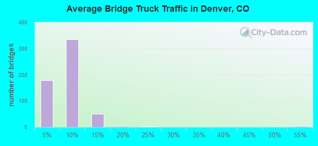
- 1,763,899Total average daily truck traffic
- National Bridge Inventory (NBI) Registered Bridges for Denver
- No street view available for this location
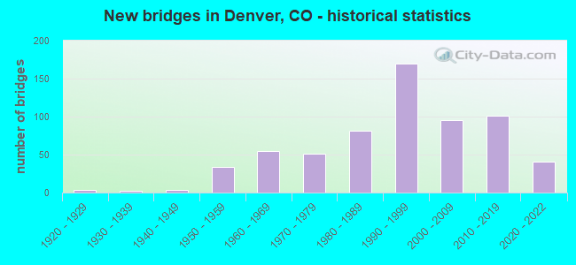
- New bridges - historical statistics
- 11910-1919
- 41920-1929
- 21930-1939
- 31940-1949
- 341950-1959
- 551960-1969
- 511970-1979
- 811980-1989
- 1701990-1999
- 952000-2009
- 1012010-2019
- 412020-2022
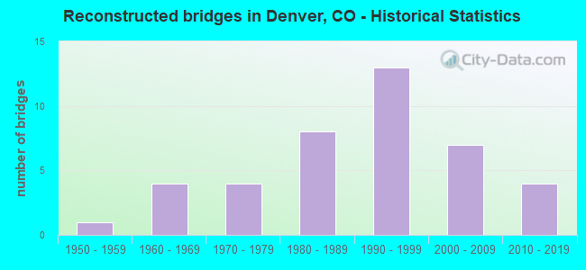
- Reconstructed bridges - Historical Statistics
- 11950-1959
- 41960-1969
- 41970-1979
- 81980-1989
- 131990-1999
- 72000-2009
- 42010-2019
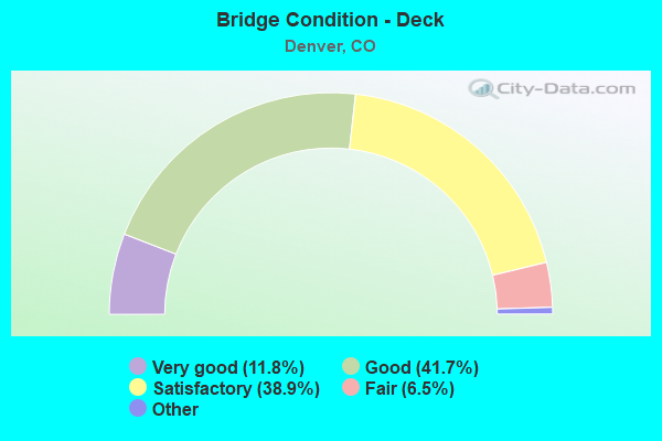
- Bridge Condition - Deck
- 11.8%Very good
- 41.7%Good
- 38.9%Satisfactory
- 6.5%Fair
- 1.0%Poor
- 0.3%Serious
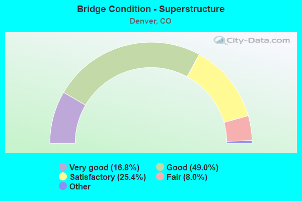
- Bridge Condition - Superstructure
- 16.8%Very good
- 49.0%Good
- 25.4%Satisfactory
- 8.0%Fair
- 0.8%Poor
- 0.3%Serious
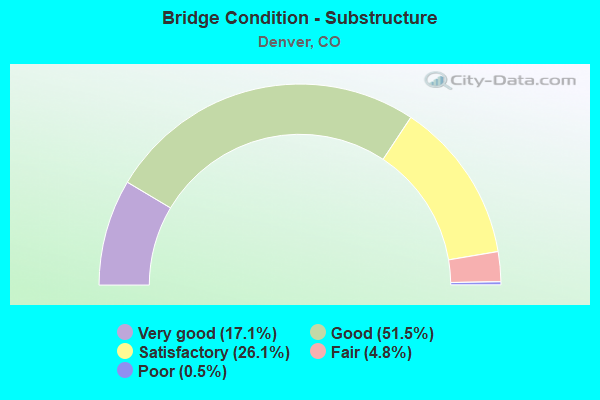
- Bridge Condition - Substructure
- 17.1%Very good
- 51.5%Good
- 26.1%Satisfactory
- 4.8%Fair
- 0.5%Poor
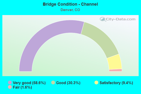
- Bridge Condition - Channel
- 58.6%Very good
- 30.3%Good
- 9.4%Satisfactory
- 1.6%Fair
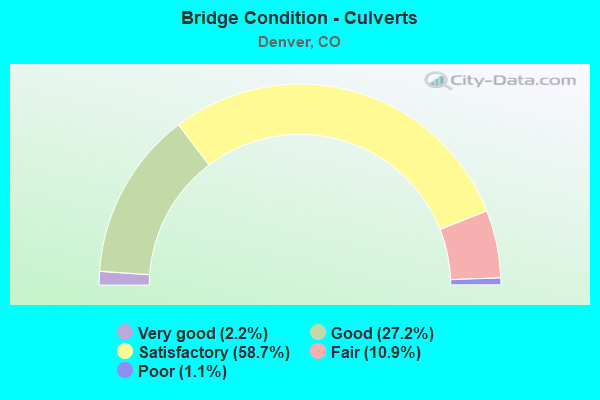
- Bridge Condition - Culverts
- 2.2%Very good
- 27.2%Good
- 58.7%Satisfactory
- 10.9%Fair
- 1.1%Poor
Find on map >> Show street view
Structure Number: D-31-PB-85, Location: SW CORNER WEST PARKING ST (Lat: 39.848153, Lng: -104.677894), Route carried "on" structure: City street , Year Built: 1993, Status: Open, Structure Length: 3.92m (12.86ft), Average Daily Traffic: 2,342 (year 2021), Truck Traffic: 5%, Average Future Daily Traffic: 2,599 (year 2041), Design Load: HS 20, Features Intersected: 84TH AVENUE, Facility Carried by Structure: SW 2ND LEVEL ENT
Minimum Vertical Clearance: 3.89m (12.76ft), Kilometerpoint: 0.000, Lanes on structure: 2, Lanes under structure: 2, Owner: Local Agency, Approaching Roadway Width: 10.7m (35.1ft), Material/Design: Prestressed concrete, Design/Construction: Box Beam or Girders - Single/Spread, Number Of Spans In Main Unit: 1, Number Of Approach Spans: 2, Length of Maximum Span: 14.9m (48.9ft), Curb-To-Curb Width: 10.9m (35.8ft), Out-to-Out Width: 11.7m (38.4ft)
Condition: Deck: Satisfactory, Superstructure: Good, Substructure: Satisfactory, Operating Rating: 43.7 metric tons, Method Used To Determine Operating Rating: Load Factor (LF), Inventory Rating: 25.8 metric tons, Method Used To Determine Inventory Rating: Load Factor (LF), Structural Evaluation: Equal to present minimum criteria, Deck Geometry: Somewhat better than minimum adequacy, Underclear: High priority of corrective action, Approach Roadway Alignment: Equal to present desirable criteria, Designated Inspection Frequency: Every 24 months, Inspection Date: December 2020, Deck Structure Type: Concrete Cast-file-Place, Wearing Surface/Protective System: Wearing Surface: Monolithic Concrete, Deck Protection: Epoxy Coated Reinforcing
Find on map >> Show street view
Structure Number: D-31-PB-881, Location: WEST OF PARKING STRUCTURE (Lat: 39.848661, Lng: -104.677592), Route carried "on" structure: City street , Year Built: 1993, Status: Open, Structure Length: 2.83m (9.28ft), Average Daily Traffic: 1,579 (year 2021), Average Future Daily Traffic: 1,753 (year 2041), Design Load: HS 20, Features Intersected: FUTURE PARKING LOT, Facility Carried by Structure: SW 2ND LEVEL PARK
Minimum Vertical Clearance: 2.44m (8.01ft), Kilometerpoint: 0.000, Lanes on structure: 2, Owner: Local Agency, Approaching Roadway Width: 10.1m (33.1ft), Material/Design: Prestressed concrete, Design/Construction: Box Beam or Girders - Single/Spread, Number Of Spans In Main Unit: 1, Number Of Approach Spans: 2, Length of Maximum Span: 14.3m (46.9ft), Curb-To-Curb Width: 10.3m (33.8ft), Out-to-Out Width: 11.5m (37.7ft)
Condition: Deck: Satisfactory, Superstructure: Good, Substructure: Satisfactory, Operating Rating: 46.0 metric tons, Method Used To Determine Operating Rating: Load Factor (LF), Inventory Rating: 27.6 metric tons, Method Used To Determine Inventory Rating: Load Factor (LF), Structural Evaluation: Equal to present minimum criteria, Deck Geometry: High priority of corrective action, Approach Roadway Alignment: Equal to present desirable criteria, Designated Inspection Frequency: Every 24 months, Inspection Date: December 2020, Deck Structure Type: Concrete Cast-file-Place, Wearing Surface/Protective System: Wearing Surface: Monolithic Concrete, Deck Protection: Epoxy Coated Reinforcing
Find on map >> Show street view
Structure Number: D-31-PB-882, Location: WEST OF PARKING STRUCT (Lat: 39.849481, Lng: -104.677578), Route carried "on" structure: City street , Year Built: 1993, Status: Open, Structure Length: 2.83m (9.28ft), Average Daily Traffic: 1,589 (year 2021), Average Future Daily Traffic: 1,763 (year 2041), Design Load: HS 20, Features Intersected: PARKING LOT, Facility Carried by Structure: W 2ND LEVEL PARK
Minimum Vertical Clearance: 3.10m (10.17ft), Kilometerpoint: 0.000, Lanes on structure: 2, Owner: Local Agency, Approaching Roadway Width: 10.1m (33.1ft), Material/Design: Prestressed concrete, Design/Construction: Box Beam or Girders - Single/Spread, Number Of Spans In Main Unit: 1, Number Of Approach Spans: 2, Length of Maximum Span: 14.3m (46.9ft), Curb-To-Curb Width: 10.3m (33.8ft), Out-to-Out Width: 11.5m (37.7ft)
Condition: Deck: Satisfactory, Superstructure: Good, Substructure: Satisfactory, Operating Rating: 46.0 metric tons, Method Used To Determine Operating Rating: Load Factor (LF), Inventory Rating: 27.6 metric tons, Method Used To Determine Inventory Rating: Load Factor (LF), Structural Evaluation: Equal to present minimum criteria, Deck Geometry: High priority of corrective action, Approach Roadway Alignment: Equal to present desirable criteria, Designated Inspection Frequency: Every 24 months, Inspection Date: December 2020, Deck Structure Type: Concrete Cast-file-Place, Wearing Surface/Protective System: Wearing Surface: Monolithic Concrete, Deck Protection: Epoxy Coated Reinforcing
Find on map >> Show street view
Structure Number: D-31-PB-883, Location: WEST OF PARKING STRUCTURE (Lat: 39.850300, Lng: -104.677542), Route carried "on" structure: City street , Year Built: 1993, Status: Open, Structure Length: 2.84m (9.32ft), Average Daily Traffic: 942 (year 2021), Average Future Daily Traffic: 1,045 (year 2041), Design Load: HS 20, Features Intersected: PARKING LOT, Facility Carried by Structure: NW 2ND LEVEL PARK
Minimum Vertical Clearance: 3.23m (10.60ft), Kilometerpoint: 0.000, Lanes on structure: 2, Owner: Local Agency, Approaching Roadway Width: 10.1m (33.1ft), Material/Design: Prestressed concrete, Design/Construction: Box Beam or Girders - Single/Spread, Number Of Spans In Main Unit: 1, Number Of Approach Spans: 2, Length of Maximum Span: 15.2m (49.9ft), Curb-To-Curb Width: 10.2m (33.5ft), Out-to-Out Width: 11.4m (37.4ft)
Condition: Deck: Satisfactory, Superstructure: Good, Substructure: Satisfactory, Operating Rating: 46.0 metric tons, Method Used To Determine Operating Rating: Load Factor (LF), Inventory Rating: 27.6 metric tons, Method Used To Determine Inventory Rating: Load Factor (LF), Structural Evaluation: Equal to present minimum criteria, Deck Geometry: High priority of corrective action, Approach Roadway Alignment: Equal to present desirable criteria, Designated Inspection Frequency: Every 24 months, Inspection Date: December 2020, Deck Structure Type: Concrete Cast-file-Place, Wearing Surface/Protective System: Wearing Surface: Monolithic Concrete, Deck Protection: Epoxy Coated Reinforcing
Find on map >> Show street view
Structure Number: D-31-PB-901, Location: WEST OF NEW PARKING STR (Lat: 39.847497, Lng: -104.677611), Route carried "on" structure: City street , Year Built: 2007, Status: Open, Structure Length: 3.04m (9.97ft), Average Daily Traffic: 1,139 (year 2021), Average Future Daily Traffic: 1,265 (year 2041), Design Load: HS 20, Features Intersected: PARKING LOT, Facility Carried by Structure: SW 2ND LEVEL NEW
Minimum Vertical Clearance: 3.00m (9.84ft), Kilometerpoint: 0.000, Lanes on structure: 2, Owner: Local Agency, Approaching Roadway Width: 11.9m (39.0ft), Material/Design: Prestressed concrete, Design/Construction: Tee Beam, Number Of Spans In Main Unit: 3, Length of Maximum Span: 17.5m (57.4ft), Curb-To-Curb Width: 11.9m (39.0ft), Out-to-Out Width: 12.3m (40.4ft)
Condition: Deck: Satisfactory, Superstructure: Satisfactory, Substructure: Good, Operating Rating: 36.3 metric tons, Method Used To Determine Operating Rating: Field evaluation and documented engineering judgment, Inventory Rating: 32.7 metric tons, Method Used To Determine Inventory Rating: Field evaluation and documented engineering judgment, Structural Evaluation: Equal to present minimum criteria, Deck Geometry: High priority of corrective action, Approach Roadway Alignment: Equal to present desirable criteria, Designated Inspection Frequency: Every 24 months, Inspection Date: December 2020, Deck Structure Type: Concrete Cast-file-Place, Wearing Surface/Protective System: Wearing Surface: Monolithic Concrete, Deck Protection: Epoxy Coated Reinforcing
Find on map >> Show street view
Structure Number: D-31-PB-902, Location: BTWN SW GARAGES (Lat: 39.848056, Lng: -104.675672), Route carried "on" structure: City street , Year Built: 2007, Status: Open, Structure Length: 3.82m (12.53ft), Average Daily Traffic: 348 (year 2021), Average Future Daily Traffic: 386 (year 2041), Design Load: HS 20, Features Intersected: 84TH AVENUE, Facility Carried by Structure: SW 4/5TH LVL PARK
Minimum Vertical Clearance: 30.45m (99.90ft), Kilometerpoint: 0.000, Lanes on structure: 2, Lanes under structure: 4, Owner: Local Agency, Approaching Roadway Width: 8.2m (26.9ft), Skew: 20 degrees, Material/Design: Prestressed concrete, Design/Construction: Tee Beam, Number Of Spans In Main Unit: 3, Length of Maximum Span: 17.6m (57.7ft), Curb or Sidewalk Widths: Left: 0.0m, Right: 3.2m (10.5ft), Curb-To-Curb Width: 7.0m (23.0ft), Out-to-Out Width: 14.0m (45.9ft)
Condition: Deck: Good, Superstructure: Satisfactory, Substructure: Good, Operating Rating: 36.3 metric tons, Method Used To Determine Operating Rating: Field evaluation and documented engineering judgment, Inventory Rating: 32.7 metric tons, Method Used To Determine Inventory Rating: Field evaluation and documented engineering judgment, Structural Evaluation: Equal to present minimum criteria, Deck Geometry: High priority of corrective action, Underclear: Meets minimum limits, Approach Roadway Alignment: Equal to present desirable criteria, Designated Inspection Frequency: Every 24 months, Inspection Date: December 2020, Deck Structure Type: Concrete Cast-file-Place, Wearing Surface/Protective System: Wearing Surface: Monolithic Concrete, Deck Protection: Epoxy Coated Reinforcing
Find on map >> Show street view
Structure Number: D-32-SCND-01, Location: 0.4 MILE NORTH OF 64th AV (Lat: 39.816578, Lng: -104.762489), Route carried "on" structure: City street , Year Built: 2006, Status: Open, Structure Length: 1.16m (3.81ft), Average Daily Traffic: 876 (year 2021), Truck Traffic: 1%, Average Future Daily Traffic: 972 (year 2041), Design Load: HS 20, Features Intersected: SECOND CREEK, Facility Carried by Structure: DUNKIRK STREET
Minimum Vertical Clearance: 30.17m (98.98ft), Kilometerpoint: 0.000, Lanes on structure: 2, Owner: City or Municipal Highway Agency, Approaching Roadway Width: 7.3m (24.0ft), Material/Design: Concrete, Design/Construction: Arch - Thru, Number Of Spans In Main Unit: 1, Length of Maximum Span: 11.0m (36.1ft), Curb or Sidewalk Widths: Left: 0.0m, Right: 2.4m (7.9ft), Curb-To-Curb Width: 19.6m (64.3ft), Out-to-Out Width: 22.9m (75.1ft)
Condition: Deck: Satisfactory, Superstructure: Satisfactory, Substructure: Good, Channel: Very good, Operating Rating: 36.3 metric tons, Method Used To Determine Operating Rating: Field evaluation and documented engineering judgment, Inventory Rating: 32.7 metric tons, Method Used To Determine Inventory Rating: Field evaluation and documented engineering judgment, Structural Evaluation: Equal to present minimum criteria, Deck Geometry: Superior to present desirable criteria, Waterway Adequacy: Equal to present desirable criteria, Approach Roadway Alignment: Equal to present desirable criteria, Designated Inspection Frequency: Every 24 months, Inspection Date: October 2020, Deck Structure Type: Other, Wearing Surface/Protective System: Wearing Surface: Bituminous
Find on map >> Show street view
Structure Number: D-32-SCND-03, Location: 0.3 MI E OF TOWER RD (Lat: 39.819492, Lng: -104.766569), Route carried "on" structure: City street , Year Built: 2020, Status: Open, Structure Length: 2.08m (6.82ft), Average Daily Traffic: 1 (year 2021), Average Future Daily Traffic: 1 (year 2041), Design Load: HL 93, Features Intersected: SECOND CREEK TRIB, Facility Carried by Structure: WB HIGH POINT BLVD
Minimum Vertical Clearance: 30+ m (98+ ft), Kilometerpoint: 0.000, Lanes on structure: 2, Owner: City or Municipal Highway Agency, Approaching Roadway Width: 9.1m (29.9ft), Skew: 2 degrees, Material/Design: Prestressed concrete, Design/Construction: Stringer/Multi-beam, Number Of Spans In Main Unit: 1, Length of Maximum Span: 17.9m (58.7ft), Curb or Sidewalk Widths: Left: 2.4m (7.9ft), Right: 0.0m, Curb-To-Curb Width: 9.1m (29.9ft), Out-to-Out Width: 12.6m (41.3ft)
Condition: Deck: Very good, Superstructure: Good, Substructure: Very good, Channel: Very good, Operating Rating: 65.4 metric tons, Method Used To Determine Operating Rating: Load and Resistance Factor Rating (LRFR) rating reported by rating factor(RF) method using HL-93 loadings, Inventory Rating: 35.0 metric tons, Method Used To Determine Inventory Rating: Load and Resistance Factor Rating (LRFR) rating reported by rating factor(RF) method using HL-93 loadings, Structural Evaluation: Better than present minimum criteria, Deck Geometry: Meets minimum limits, Waterway Adequacy: Equal to present desirable criteria, Approach Roadway Alignment: Equal to present desirable criteria, Designated Inspection Frequency: Every 24 months, Inspection Date: January 2021, Deck Structure Type: Concrete Cast-file-Place, Wearing Surface/Protective System: Wearing Surface: Bituminous, Membrane: Built-up, Deck Protection: Epoxy Coated Reinforcing
Find on map >> Show street view
Structure Number: D-32-SCND-031, Location: 0.3 MI E OF TOWER RD (Lat: 39.819419, Lng: -104.766483), Route carried "on" structure: City street , Year Built: 2020, Status: Open, Structure Length: 2.08m (6.82ft), Average Daily Traffic: 1 (year 2021), Average Future Daily Traffic: 1 (year 2041), Design Load: HL 93, Features Intersected: SECOND CREEK TRIB, Facility Carried by Structure: EB HIGH POINT BLVD
Minimum Vertical Clearance: 30+ m (98+ ft), Kilometerpoint: 0.000, Lanes on structure: 2, Owner: City or Municipal Highway Agency, Approaching Roadway Width: 9.1m (29.9ft), Skew: 2 degrees, Material/Design: Prestressed concrete, Design/Construction: Stringer/Multi-beam, Number Of Spans In Main Unit: 1, Length of Maximum Span: 17.9m (58.7ft), Curb or Sidewalk Widths: Left: 0.0m, Right: 1.5m (4.9ft), Curb-To-Curb Width: 9.1m (29.9ft), Out-to-Out Width: 11.6m (38.1ft)
Condition: Deck: Very good, Superstructure: Good, Substructure: Very good, Channel: Very good, Operating Rating: 63.5 metric tons, Method Used To Determine Operating Rating: Load and Resistance Factor (LRFR), Inventory Rating: 36.2 metric tons, Method Used To Determine Inventory Rating: Load and Resistance Factor (LRFR), Structural Evaluation: Better than present minimum criteria, Deck Geometry: Meets minimum limits, Waterway Adequacy: Equal to present desirable criteria, Approach Roadway Alignment: Equal to present desirable criteria, Designated Inspection Frequency: Every 24 months, Inspection Date: January 2021, Deck Structure Type: Concrete Cast-file-Place, Wearing Surface/Protective System: Wearing Surface: Bituminous, Membrane: Built-up, Deck Protection: Epoxy Coated Reinforcing
Find on map >> Show street view
Structure Number: D-33-GW-1, Location: YORK ST / GRNWAY CHANNEL (Lat: 39.771283, Lng: -104.959633), Route carried "on" structure: City street , Year Built: 2020, Status: Open, Structure Length: 1.71m (5.61ft), Average Daily Traffic: 16,808 (year 2021), Truck Traffic: 6%, Average Future Daily Traffic: 18,657 (year 2041), Design Load: HL 93, Features Intersected: GREENWAY CHANNEL, Facility Carried by Structure: YORK STREET
Minimum Vertical Clearance: 30+ m (98+ ft), Kilometerpoint: 5.226, Lanes on structure: 4, Owner: City or Municipal Highway Agency, Approaching Roadway Width: 14.6m (47.9ft), Material/Design: Prestressed concrete, Design/Construction: Box Beam or Girders - Multiple, Number Of Spans In Main Unit: 1, Length of Maximum Span: 15.2m (49.9ft), Curb or Sidewalk Widths: Left: 2.1m (6.9ft), Right: 3.0m (9.8ft), Curb-To-Curb Width: 14.6m (47.9ft), Out-to-Out Width: 20.7m (67.9ft)
Condition: Deck: Very good, Superstructure: Very good, Substructure: Very good, Channel: Very good, Operating Rating: 60.2 metric tons, Method Used To Determine Operating Rating: Load and Resistance Factor (LRFR), Inventory Rating: 38.3 metric tons, Method Used To Determine Inventory Rating: Load and Resistance Factor (LRFR), Structural Evaluation: Equal to present desirable criteria, Deck Geometry: High priority of replacement, Waterway Adequacy: Equal to present desirable criteria, Approach Roadway Alignment: Equal to present desirable criteria, Designated Inspection Frequency: Every 24 months, Inspection Date: January 2021, Deck Structure Type: Concrete Cast-file-Place, Wearing Surface/Protective System: Wearing Surface: Bituminous, Membrane: Preformed Fabric, Deck Protection: Epoxy Coated Reinforcing
Find on map >> Show street view
Structure Number: D-33-GW-25, Location: WILLIAMS ST/GRNWY CHANNEL (Lat: 39.771089, Lng: -104.965861), Route carried "on" structure: City street , Year Built: 2020, Status: Open, Structure Length: 1.10m (3.61ft), Average Daily Traffic: 881 (year 2021), Average Future Daily Traffic: 978 (year 2041), Design Load: HL 93, Features Intersected: GREENWAY CHANNEL, Facility Carried by Structure: WILLIAMS STREET
Minimum Vertical Clearance: 30+ m (98+ ft), Kilometerpoint: 2.612, Lanes on structure: 2, Owner: City or Municipal Highway Agency, Approaching Roadway Width: 7.6m (24.9ft), Material/Design: Prestressed concrete, Design/Construction: Box Beam or Girders - Multiple, Number Of Spans In Main Unit: 1, Length of Maximum Span: 9.1m (29.9ft), Curb or Sidewalk Widths: Left: 2.4m (7.9ft), Right: 2.4m (7.9ft), Curb-To-Curb Width: 7.6m (24.9ft), Out-to-Out Width: 13.4m (44.0ft)
Condition: Deck: Good, Superstructure: Very good, Substructure: Very good, Channel: Very good, Structural Evaluation: Equal to present desirable criteria, Deck Geometry: Meets minimum limits, Waterway Adequacy: Equal to present desirable criteria, Approach Roadway Alignment: Equal to present desirable criteria, Designated Inspection Frequency: Every 24 months, Inspection Date: January 2021, Deck Structure Type: Concrete Cast-file-Place, Wearing Surface/Protective System: Wearing Surface: Bituminous, Membrane: Preformed Fabric, Deck Protection: Epoxy Coated Reinforcing
Find on map >> Show street view
Structure Number: E-16-DN, Location: DENVER (Lat: 39.783283, Lng: -105.034831), Route carried "on" structure: Interstate 70A, Year Built: 1966, Status: Open, Structure Length: 4.33m (14.21ft), Average Daily Traffic: 90,000 (year 2020), Truck Traffic: 6%, Average Future Daily Traffic: 104,400 (year 2040), Design Load: HS 20, Features Intersected: LOWELL BLVD, Facility Carried by Structure: I 70 ML
Minimum Vertical Clearance: 4.98m (16.34ft), Kilometerpoint: 438.298, Lanes on structure: 6, Lanes under structure: 2, Base Highway Network: Yes, Owner: State Highway Agency, Approaching Roadway Width: 30.5m (100.1ft), Skew: 30 degrees, Material/Design: Concrete continuous, Design/Construction: Tee Beam, Number Of Spans In Main Unit: 3, Length of Maximum Span: 23.9m (78.4ft), Curb-To-Curb Width: 30.5m (100.1ft), Out-to-Out Width: 32.3m (106.0ft)
Condition: Deck: Fair, Superstructure: Fair, Substructure: Satisfactory, Operating Rating: 32.7 metric tons, Method Used To Determine Operating Rating: Load Factor (LF), Inventory Rating: 20.0 metric tons, Method Used To Determine Inventory Rating: Load Factor (LF), Structural Evaluation: Somewhat better than minimum adequacy, Deck Geometry: Superior to present desirable criteria, Underclear: Somewhat better than minimum adequacy, Approach Roadway Alignment: Equal to present desirable criteria, Designated Inspection Frequency: Every 24 months, Inspection Date: September 2021, Deck Structure Type: Other, Wearing Surface/Protective System: Wearing Surface: Bituminous
Find on map >> Show street view
Structure Number: E-16-DY, Location: ½ MI. E. OF HWY 95 (Lat: 4.586122, Lng: -610.839975), Route carried "on" structure: Interstate 70A, Structure Length: 4000.46m (13124.87ft), Average Daily Traffic: 209,000 (year 0202), Features Intersected: TENNYSON STREET, Facility Carried by Structure: I 70 ML
Kilometerpoint: 9043.749, Lanes on structure: 60, Lanes under structure: 60, Approaching Roadway Width: 503.0m (1,650.3ft), Skew: 3 degrees, Material/Design: Concrete, Design/Construction: Mixed types, Number Of Approach Spans: 3000, Length of Maximum Span: 2002.0m (6,568.2ft), Curb or Sidewalk Widths: Left: 10.0m (32.8ft), Right: 0.0m, Curb-To-Curb Width: 3.0m (9.8ft), Out-to-Out Width: 503.2m (1,650.9ft)
Condition: Deck: Fair, Superstructure: Satisfactory, Substructure: Good, Operating Rating: 55.0 metric tons, Method Used To Determine Operating Rating: Load Factor (LF), Inventory Rating: 32.3 metric tons, Method Used To Determine Inventory Rating: Load Factor (LF), Designated Inspection Frequency: Every 2 months, Inspection Date: 2001, Deck Structure Type: Other
Find on map >> Show street view
Structure Number: E-16-EM, Location: SO. OF PARK AVE. (Lat: 39.766619, Lng: -104.997983), Route carried "on" structure: Interstate 25A, Year Built: 1949, Year Reconstructed: 1992, Status: Open, Structure Length: 9.77m (32.05ft), Average Daily Traffic: 242,000 (year 2020), Truck Traffic: 9%, Average Future Daily Traffic: 278,300 (year 2040), Design Load: HS 25 or greater, Features Intersected: RR SPUR, Facility Carried by Structure: I 25 ML
Minimum Vertical Clearance: 30+ m (98+ ft), Kilometerpoint: 341.813, Lanes on structure: 14, Base Highway Network: Yes, Owner: State Highway Agency, Approaching Roadway Width: 69.5m (228.0ft), Skew: 32 degrees, Material/Design: Steel continuous, Design/Construction: Stringer/Multi-beam, Number Of Spans In Main Unit: 6, Length of Maximum Span: 18.9m (62.0ft), Curb-To-Curb Width: 69.5m (228.0ft), Out-to-Out Width: 71.6m (234.9ft)
Condition: Deck: Satisfactory, Superstructure: Good, Substructure: Satisfactory, Operating Rating: 64.7 metric tons, Method Used To Determine Operating Rating: Load Factor (LF), Inventory Rating: 38.7 metric tons, Method Used To Determine Inventory Rating: Load Factor (LF), Structural Evaluation: Equal to present minimum criteria, Deck Geometry: Superior to present desirable criteria, Underclear: Meets minimum limits, Approach Roadway Alignment: Equal to present desirable criteria, Designated Inspection Frequency: Every 24 months, Inspection Date: June 2020, Deck Structure Type: Concrete Cast-file-Place, Wearing Surface/Protective System: Wearing Surface: Bituminous, Membrane: Preformed Fabric, Deck Protection: Epoxy Coated Reinforcing
Find on map >> Show street view
Structure Number: E-16-EO, Location: IN DENVER (Lat: 39.755072, Lng: -105.012400), Route carried "on" structure: City street , Year Built: 1952, Status: Open, Structure Length: 7.85m (25.75ft), Average Daily Traffic: 17,812 (year 2021), Truck Traffic: 9%, Average Future Daily Traffic: 19,771 (year 2041), Design Load: H 20, Features Intersected: I 25 ML, Facility Carried by Structure: SPEER BLVD SBND
Minimum Vertical Clearance: 30+ m (98+ ft), Kilometerpoint: 3.965, Lanes on structure: 3, Lanes under structure: 10, Owner: State Highway Agency, Approaching Roadway Width: 18.0m (59.1ft), Skew: 12 degrees, Material/Design: Concrete continuous, Design/Construction: Frame, Number Of Spans In Main Unit: 2, Number Of Approach Spans: 3, Length of Maximum Span: 25.3m (83.0ft), Curb-To-Curb Width: 12.2m (40.0ft), Out-to-Out Width: 14.1m (46.3ft)
Condition: Deck: Poor, Superstructure: Fair, Substructure: Fair, Operating Rating: 56.3 metric tons, Method Used To Determine Operating Rating: Load Factor (LF), Inventory Rating: 33.6 metric tons, Method Used To Determine Inventory Rating: Load Factor (LF), Structural Evaluation: Somewhat better than minimum adequacy, Deck Geometry: Meets minimum limits, Underclear: High priority of replacement, Approach Roadway Alignment: Equal to present desirable criteria, Length Of Structure Improvement: 7.90m (25.92ft), Designated Inspection Frequency: Every 24 months, Inspection Date: July 2020, Bridge Improvement Cost: $3,961,000, Roadway Improvement Cost: $396,000, Total Project Cost: $5,941,000 ( Estimate for 2016), Deck Structure Type: Concrete Cast-file-Place, Wearing Surface/Protective System: Wearing Surface: Bituminous, Membrane: Preformed Fabric
Find on map >> Show street view
Structure Number: E-16-EW, Location: IN DENVER (Lat: 39.755236, Lng: -105.012153), Route carried "on" structure: City street , Year Built: 1952, Status: Open, Structure Length: 7.89m (25.89ft), Average Daily Traffic: 13,751 (year 2021), Truck Traffic: 9%, Average Future Daily Traffic: 15,263 (year 2041), Design Load: H 20, Features Intersected: I 25 ML, Facility Carried by Structure: SPEER BLVD NBND
Minimum Vertical Clearance: 30+ m (98+ ft), Kilometerpoint: 3.875, Lanes on structure: 4, Lanes under structure: 10, Base Highway Network: Yes, Owner: State Highway Agency, Approaching Roadway Width: 16.5m (54.1ft), Skew: 12 degrees, Material/Design: Concrete continuous, Design/Construction: Frame, Number Of Spans In Main Unit: 2, Number Of Approach Spans: 3, Length of Maximum Span: 26.2m (86.0ft), Curb or Sidewalk Widths: Left: 0.6m (2.0ft), Right: 0.6m (2.0ft), Curb-To-Curb Width: 12.2m (40.0ft), Out-to-Out Width: 14.1m (46.3ft)
Condition: Deck: Fair, Superstructure: Fair, Substructure: Satisfactory, Operating Rating: 56.3 metric tons, Method Used To Determine Operating Rating: Load Factor (LF), Inventory Rating: 33.6 metric tons, Method Used To Determine Inventory Rating: Load Factor (LF), Structural Evaluation: Somewhat better than minimum adequacy, Deck Geometry: High priority of replacement, Underclear: High priority of replacement, Approach Roadway Alignment: Equal to present desirable criteria, Length Of Structure Improvement: 7.89m (25.89ft), Designated Inspection Frequency: Every 24 months, Inspection Date: July 2020, Bridge Improvement Cost: $1,899,000, Roadway Improvement Cost: $190,000, Total Project Cost: $2,849,000, Deck Structure Type: Concrete Cast-file-Place, Wearing Surface/Protective System: Wearing Surface: Bituminous
Find on map >> Show street view
Structure Number: E-16-EY, Location: DENVER (Lat: 39.783492, Lng: -105.016067), Route carried "on" structure: Interstate 70A, Year Built: 1965, Status: Open, Structure Length: 3.69m (12.11ft), Average Daily Traffic: 130,000 (year 2020), Truck Traffic: 7%, Average Future Daily Traffic: 156,000 (year 2040), Design Load: HS 20+Mod, Features Intersected: ZUNI STREET, Facility Carried by Structure: I 70 ML
Minimum Vertical Clearance: 30+ m (98+ ft), Kilometerpoint: 439.919, Lanes on structure: 6, Lanes under structure: 2, Base Highway Network: Yes, Owner: State Highway Agency, Approaching Roadway Width: 34.1m (111.9ft), Skew: 30 degrees, Material/Design: Concrete continuous, Design/Construction: Tee Beam, Number Of Spans In Main Unit: 3, Length of Maximum Span: 20.1m (65.9ft), Curb-To-Curb Width: 31.1m (102.0ft), Out-to-Out Width: 32.9m (107.9ft)
Condition: Deck: Fair, Superstructure: Satisfactory, Substructure: Good, Operating Rating: 44.5 metric tons, Method Used To Determine Operating Rating: Load Factor (LF), Inventory Rating: 26.3 metric tons, Method Used To Determine Inventory Rating: Load Factor (LF), Structural Evaluation: Equal to present minimum criteria, Deck Geometry: Superior to present desirable criteria, Underclear: Somewhat better than minimum adequacy, Approach Roadway Alignment: Equal to present desirable criteria, Designated Inspection Frequency: Every 24 months, Inspection Date: August 2021, Deck Structure Type: Other, Wearing Surface/Protective System: Wearing Surface: Bituminous
Find on map >> Show street view
Structure Number: E-16-FA, Location: IN DENVER (Lat: 39.767606, Lng: -104.995322), Route carried "on" structure: Interstate 25A, Year Built: 1949, Year Reconstructed: 1992, Status: Open, Structure Length: 7.15m (23.46ft), Average Daily Traffic: 242,000 (year 2020), Truck Traffic: 9%, Average Future Daily Traffic: 278,300 (year 2040), Design Load: HS 20, Features Intersected: FOX STREET, Facility Carried by Structure: I 25 ML
Minimum Vertical Clearance: 30+ m (98+ ft), Kilometerpoint: 0.357, Lanes on structure: 14, Lanes under structure: 6, Base Highway Network: Yes, Owner: State Highway Agency, Approaching Roadway Width: 75.0m (246.1ft), Skew: 32 degrees, Material/Design: Prestressed concrete continuous, Design/Construction: Box Beam or Girders - Single/Spread, Number Of Spans In Main Unit: 4, Length of Maximum Span: 20.4m (66.9ft), Curb-To-Curb Width: 75.0m (246.1ft), Out-to-Out Width: 77.1m (253.0ft)
Condition: Deck: Good, Superstructure: Good, Substructure: Good, Operating Rating: 60.8 metric tons, Method Used To Determine Operating Rating: Load Factor (LF), Inventory Rating: 36.3 metric tons, Method Used To Determine Inventory Rating: Load Factor (LF), Structural Evaluation: Better than present minimum criteria, Deck Geometry: Superior to present desirable criteria, Underclear: Somewhat better than minimum adequacy, Approach Roadway Alignment: Equal to present desirable criteria, Designated Inspection Frequency: Every 24 months, Inspection Date: June 2020, Deck Structure Type: Concrete Cast-file-Place, Wearing Surface/Protective System: Wearing Surface: Bituminous, Membrane: Preformed Fabric, Deck Protection: Epoxy Coated Reinforcing
Find on map >> Show street view
Structure Number: E-16-FJ, Location: DENVER, FEDERAL BLVD. (Lat: 39.784025, Lng: -105.025025), Route carried "on" structure: US 287C, Year Built: 1965, Status: Open, Structure Length: 6.16m (20.21ft), Average Daily Traffic: 31,000 (year 2020), Truck Traffic: 3%, Average Future Daily Traffic: 33,480 (year 2040), Design Load: H 20, Features Intersected: I 70 ML, Facility Carried by Structure: US 287 ML
Minimum Vertical Clearance: 30+ m (98+ ft), Kilometerpoint: 4.843, Lanes on structure: 6, Lanes under structure: 6, Base Highway Network: Yes, Owner: State Highway Agency, Approaching Roadway Width: 19.5m (64.0ft), Material/Design: Prestressed concrete continuous, Design/Construction: Tee Beam, Number Of Spans In Main Unit: 3, Length of Maximum Span: 34.7m (113.8ft), Curb or Sidewalk Widths: Left: 1.4m (4.6ft), Right: 1.4m (4.6ft), Curb-To-Curb Width: 25.0m (82.0ft), Out-to-Out Width: 28.7m (94.2ft)
Condition: Deck: Good, Superstructure: Good, Substructure: Satisfactory, Operating Rating: 45.4 metric tons, Method Used To Determine Operating Rating: Load Factor (LF), Inventory Rating: 27.2 metric tons, Method Used To Determine Inventory Rating: Load Factor (LF), Structural Evaluation: Equal to present minimum criteria, Deck Geometry: Somewhat better than minimum adequacy, Underclear: Equal to present minimum criteria, Approach Roadway Alignment: Equal to present desirable criteria, Designated Inspection Frequency: Every 24 months, Inspection Date: March 2021, Deck Structure Type: Concrete Cast-file-Place, Wearing Surface/Protective System: Wearing Surface: Bituminous
Find on map >> Show street view
Structure Number: E-16-IP, Location: .4 MI E OF MARSHALL-I76 (Lat: 39.790836, Lng: -105.062725), Route carried "on" structure: Interstate 76A, Year Built: 1983, Status: Open, Structure Length: 7.43m (24.38ft), Average Daily Traffic: 38,000 (year 2020), Truck Traffic: 11%, Average Future Daily Traffic: 50,160 (year 2040), Design Load: HS 20+Mod, Features Intersected: 52ND AVE, Facility Carried by Structure: I 76 EBND
Minimum Vertical Clearance: 30+ m (98+ ft), Kilometerpoint: 1.429, Lanes on structure: 2, Lanes under structure: 2, Base Highway Network: Yes, Owner: State Highway Agency, Approaching Roadway Width: 11.6m (38.1ft), Skew: 14 degrees, Material/Design: Prestressed concrete continuous, Design/Construction: Box Beam or Girders - Multiple, Number Of Spans In Main Unit: 2, Length of Maximum Span: 36.6m (120.1ft), Curb-To-Curb Width: 11.6m (38.1ft), Out-to-Out Width: 12.5m (41.0ft)
Condition: Deck: Good, Superstructure: Good, Substructure: Good, Operating Rating: 53.5 metric tons, Method Used To Determine Operating Rating: Load Factor (LF), Inventory Rating: 31.8 metric tons, Method Used To Determine Inventory Rating: Load Factor (LF), Structural Evaluation: Better than present minimum criteria, Deck Geometry: Equal to present minimum criteria, Underclear: Superior to present desirable criteria, Approach Roadway Alignment: Equal to present desirable criteria, Designated Inspection Frequency: Every 24 months, Inspection Date: December 2020, Deck Structure Type: Concrete Cast-file-Place, Wearing Surface/Protective System: Wearing Surface: Bituminous, Membrane: Preformed Fabric, Deck Protection: Epoxy Coated Reinforcing
Find on map >> Show street view
Structure Number: E-16-IQ, Location: 1.2 MI E OF WADSWORTH (Lat: 39.790831, Lng: -105.063142), Route carried "on" structure: Interstate 76A, Year Built: 1983, Status: Open, Structure Length: 7.43m (24.38ft), Average Daily Traffic: 38,000 (year 2020), Truck Traffic: 11%, Average Future Daily Traffic: 50,160 (year 2040), Design Load: HS 20+Mod, Features Intersected: 52ND AVE, Facility Carried by Structure: I 76 WBND
Minimum Vertical Clearance: 30+ m (98+ ft), Kilometerpoint: 1.402, Lanes on structure: 2, Lanes under structure: 2, Base Highway Network: Yes, Owner: State Highway Agency, Approaching Roadway Width: 11.6m (38.1ft), Skew: 14 degrees, Material/Design: Prestressed concrete, Design/Construction: Box Beam or Girders - Single/Spread, Number Of Spans In Main Unit: 2, Length of Maximum Span: 36.6m (120.1ft), Curb-To-Curb Width: 11.6m (38.1ft), Out-to-Out Width: 12.5m (41.0ft)
Condition: Deck: Good, Superstructure: Satisfactory, Substructure: Good, Operating Rating: 53.5 metric tons, Method Used To Determine Operating Rating: Load Factor (LF), Inventory Rating: 31.8 metric tons, Method Used To Determine Inventory Rating: Load Factor (LF), Structural Evaluation: Equal to present minimum criteria, Deck Geometry: Equal to present minimum criteria, Underclear: Superior to present desirable criteria, Approach Roadway Alignment: Equal to present desirable criteria, Designated Inspection Frequency: Every 24 months, Inspection Date: December 2020, Deck Structure Type: Concrete Cast-file-Place, Wearing Surface/Protective System: Wearing Surface: Bituminous, Membrane: Preformed Fabric, Deck Protection: Epoxy Coated Reinforcing
Find on map >> Show street view
Structure Number: E-16-ME, Location: 3.8 MI E OF I70 + I76 INT (Lat: 39.804644, Lng: -105.016333), Route carried "on" structure: Interstate 76A, Year Built: 1988, Status: Open, Structure Length: 18.84m (61.81ft), Average Daily Traffic: 38,500 (year 2020), Truck Traffic: 9%, Average Future Daily Traffic: 54,670 (year 2040), Design Load: HS 20+Mod, Features Intersected: 60TH AVE & DITCH, Facility Carried by Structure: I 76 ML WBND
Minimum Vertical Clearance: 30+ m (98+ ft), Kilometerpoint: 5.810, Lanes on structure: 2, Lanes under structure: 2, Base Highway Network: Yes, Owner: State Highway Agency, Approaching Roadway Width: 11.6m (38.1ft), Skew: 13 degrees, Material/Design: Prestressed concrete continuous, Design/Construction: Stringer/Multi-beam, Number Of Spans In Main Unit: 5, Length of Maximum Span: 42.7m (140.1ft), Curb-To-Curb Width: 11.6m (38.1ft), Out-to-Out Width: 12.5m (41.0ft)
Condition: Deck: Good, Superstructure: Good, Substructure: Good, Inventory Rating: 23.5 metric tons, Method Used To Determine Inventory Rating: Load Factor (LF), Structural Evaluation: Somewhat better than minimum adequacy, Deck Geometry: Equal to present minimum criteria, Underclear: Superior to present desirable criteria, Approach Roadway Alignment: Equal to present desirable criteria, Designated Inspection Frequency: Every 24 months, Inspection Date: April 2021, Deck Structure Type: Concrete Cast-file-Place, Wearing Surface/Protective System: Wearing Surface: Bituminous, Membrane: Preformed Fabric, Deck Protection: Epoxy Coated Reinforcing
Find on map >> Show street view
Structure Number: E-16-MO, Location: IN DENVER (Lat: 39.776456, Lng: -104.990083), Route carried "on" structure: City street , Year Built: 1988, Status: Open, Structure Length: 10.73m (35.20ft), Average Daily Traffic: 2,623 (year 2021), Truck Traffic: 2%, Average Future Daily Traffic: 2,911 (year 2041), Design Load: HS 20, Features Intersected: I 25 ML, Facility Carried by Structure: 44TH AVE
Minimum Vertical Clearance: 30+ m (98+ ft), Kilometerpoint: 0.381, Lanes on structure: 2, Lanes under structure: 15, Owner: State Highway Agency, Approaching Roadway Width: 10.7m (35.1ft), Material/Design: Steel continuous, Design/Construction: Box Beam or Girders - Multiple, Number Of Spans In Main Unit: 3, Length of Maximum Span: 49.3m (161.7ft), Curb or Sidewalk Widths: Left: 0.0m, Right: 2.1m (6.9ft), Curb-To-Curb Width: 11.0m (36.1ft), Out-to-Out Width: 14.3m (46.9ft)
Condition: Deck: Satisfactory, Superstructure: Poor, Substructure: Satisfactory, Operating Rating: 38.2 metric tons, Method Used To Determine Operating Rating: Load Factor (LF), Inventory Rating: 22.9 metric tons, Method Used To Determine Inventory Rating: Load Factor (LF), Structural Evaluation: Meets minimum limits, Deck Geometry: Somewhat better than minimum adequacy, Underclear: High priority of corrective action, Approach Roadway Alignment: Somewhat better than minimum adequacy, Designated Inspection Frequency: Every 24 months, Critical Feature Inspection Frequency: Every 24 months, Inspection Date: June 2020, Critical Feature Inspection Date: June 2020, Deck Structure Type: Concrete Cast-file-Place, Wearing Surface/Protective System: Wearing Surface: Bituminous, Membrane: Preformed Fabric, Deck Protection: Epoxy Coated Reinforcing
Find on map >> Show street view
Structure Number: E-16-MR, Location: AT I 25 AND I 70 (Lat: 39.781000, Lng: -104.993636), Route carried "on" structure: Interstate 70A, Year Built: 1991, Status: Open, Structure Length: 69.94m (229.46ft), Average Daily Traffic: 60,500 (year 2020), Truck Traffic: 7%, Average Future Daily Traffic: 70,785 (year 2040), Design Load: HS 20+Mod, Features Intersected: I 25 ML & RAMPS, Facility Carried by Structure: I 70 ML EBND
Minimum Vertical Clearance: 5.39m (17.68ft), Kilometerpoint: 441.892, Lanes on structure: 2, Lanes under structure: 16, Base Highway Network: Yes, Owner: State Highway Agency, Approaching Roadway Width: 17.1m (56.1ft), Material/Design: Steel continuous, Design/Construction: Box Beam or Girders - Single/Spread, Number Of Spans In Main Unit: 13, Length of Maximum Span: 71.9m (235.9ft), Curb-To-Curb Width: 17.1m (56.1ft), Out-to-Out Width: 18.0m (59.1ft)
Condition: Deck: Satisfactory, Superstructure: Satisfactory, Substructure: Good, Operating Rating: 61.7 metric tons, Method Used To Determine Operating Rating: Load Factor (LF), Inventory Rating: 32.7 metric tons, Method Used To Determine Inventory Rating: Load Factor (LF), Structural Evaluation: Equal to present minimum criteria, Deck Geometry: Superior to present desirable criteria, Underclear: High priority of corrective action, Approach Roadway Alignment: Equal to present desirable criteria, Designated Inspection Frequency: Every 24 months, Inspection Date: May 2020, Deck Structure Type: Concrete Cast-file-Place, Wearing Surface/Protective System: Wearing Surface: Monolithic Concrete, Deck Protection: Epoxy Coated Reinforcing
Find on map >> Show street view
Structure Number: E-16-MS, Location: AT I 25 AND I 70 (Lat: 39.781150, Lng: -104.993567), Route carried "on" structure: Interstate 70A, Year Built: 1991, Status: Open, Structure Length: 69.94m (229.46ft), Average Daily Traffic: 60,500 (year 2020), Truck Traffic: 7%, Average Future Daily Traffic: 70,785 (year 2040), Design Load: HS 20+Mod, Features Intersected: I 25 ML AND RAMPS, Facility Carried by Structure: I 70 ML WBND
Minimum Vertical Clearance: 6.99m (22.93ft), Kilometerpoint: 441.892, Lanes on structure: 2, Lanes under structure: 16, Base Highway Network: Yes, Owner: State Highway Agency, Approaching Roadway Width: 17.1m (56.1ft), Material/Design: Steel continuous, Design/Construction: Box Beam or Girders - Single/Spread, Number Of Spans In Main Unit: 13, Length of Maximum Span: 71.9m (235.9ft), Curb-To-Curb Width: 17.1m (56.1ft), Out-to-Out Width: 18.0m (59.1ft)
Condition: Deck: Satisfactory, Superstructure: Good, Substructure: Good, Operating Rating: 61.7 metric tons, Method Used To Determine Operating Rating: Load Factor (LF), Inventory Rating: 32.7 metric tons, Method Used To Determine Inventory Rating: Load Factor (LF), Structural Evaluation: Better than present minimum criteria, Deck Geometry: Superior to present desirable criteria, Underclear: Equal to present desirable criteria, Approach Roadway Alignment: Equal to present desirable criteria, Designated Inspection Frequency: Every 24 months, Inspection Date: June 2021, Deck Structure Type: Concrete Cast-file-Place, Wearing Surface/Protective System: Wearing Surface: Monolithic Concrete, Deck Protection: Epoxy Coated Reinforcing
Find on map >> Show street view
Structure Number: E-16-NJ, Location: DENVER, .4 MI W OF I-25 (Lat: 39.782214, Lng: -104.998250), Route carried "on" structure: Interstate 70A, Year Built: 1992, Year Reconstructed: 1997, Status: Open, Structure Length: 13.66m (44.82ft), Average Daily Traffic: 121,000 (year 2020), Truck Traffic: 7%, Average Future Daily Traffic: 141,570 (year 2040), Design Load: HS 20+Mod, Features Intersected: BNSF RR, UP RR, RTD LR, Facility Carried by Structure: I 70 ML
Minimum Vertical Clearance: 30+ m (98+ ft), Kilometerpoint: 441.474, Lanes on structure: 8, Base Highway Network: Yes, Owner: State Highway Agency, Approaching Roadway Width: 61.6m (202.1ft), Skew: 32 degrees, Material/Design: Steel continuous, Design/Construction: Stringer/Multi-beam, Number Of Spans In Main Unit: 3, Length of Maximum Span: 48.4m (158.8ft), Curb-To-Curb Width: 52.5m (172.2ft), Out-to-Out Width: 54.5m (178.8ft)
Condition: Deck: Satisfactory, Superstructure: Satisfactory, Substructure: Satisfactory, Operating Rating: 50.0 metric tons, Method Used To Determine Operating Rating: Load Factor (LF), Inventory Rating: 29.9 metric tons, Method Used To Determine Inventory Rating: Load Factor (LF), Structural Evaluation: Equal to present minimum criteria, Deck Geometry: Superior to present desirable criteria, Underclear: Somewhat better than minimum adequacy, Approach Roadway Alignment: Equal to present desirable criteria, Designated Inspection Frequency: Every 24 months, Inspection Date: September 2021, Deck Structure Type: Concrete Cast-file-Place, Wearing Surface/Protective System: Wearing Surface: Monolithic Concrete, Deck Protection: Epoxy Coated Reinforcing
Find on map >> Show street view
Structure Number: E-16-NW, Location: IN DENVER (Lat: 39.783703, Lng: -104.988906), Route carried "on" structure: Interstate 25A, Year Built: 1992, Status: Open, Structure Length: 5.56m (18.24ft), Average Daily Traffic: 200,000 (year 2020), Truck Traffic: 10%, Average Future Daily Traffic: 232,000 (year 2040), Design Load: HS 20, Features Intersected: 48TH AVE, RR SPUR, Facility Carried by Structure: I 25 ML
Minimum Vertical Clearance: 30+ m (98+ ft), Kilometerpoint: 0.094, Lanes on structure: 12, Lanes under structure: 2, Base Highway Network: Yes, Owner: State Highway Agency, Approaching Roadway Width: 65.2m (213.9ft), Material/Design: Prestressed concrete continuous, Design/Construction: Box Beam or Girders - Single/Spread, Number Of Spans In Main Unit: 2, Length of Maximum Span: 27.2m (89.2ft), Curb-To-Curb Width: 65.2m (213.9ft), Out-to-Out Width: 67.6m (221.8ft)
Condition: Deck: Satisfactory, Superstructure: Good, Substructure: Good, Operating Rating: 72.2 metric tons, Method Used To Determine Operating Rating: Load Factor (LF), Inventory Rating: 42.3 metric tons, Method Used To Determine Inventory Rating: Load Factor (LF), Structural Evaluation: Better than present minimum criteria, Deck Geometry: Superior to present desirable criteria, Underclear: Somewhat better than minimum adequacy, Approach Roadway Alignment: Equal to present desirable criteria, Designated Inspection Frequency: Every 24 months, Inspection Date: June 2020, Deck Structure Type: Concrete Cast-file-Place, Wearing Surface/Protective System: Wearing Surface: Monolithic Concrete, Deck Protection: Epoxy Coated Reinforcing
Find on map >> Show street view
Structure Number: E-16-NX, Location: 0.4 MI N. OF I25/I70 (Lat: 39.783703, Lng: -104.989711), Route carried "on" structure: Ramp Interstate 25A, Year Built: 1993, Status: Open, Structure Length: 5.56m (18.24ft), Average Daily Traffic: 200,000 (year 2020), Truck Traffic: 10%, Average Future Daily Traffic: 232,000 (year 2040), Design Load: HS 20, Features Intersected: 48TH AVE, RR SPUR R, Facility Carried by Structure: RAMP TO I 70 ML
Minimum Vertical Clearance: 30+ m (98+ ft), Kilometerpoint: 0.420, Lanes on structure: 2, Lanes under structure: 2, Base Highway Network: Yes, Owner: State Highway Agency, Approaching Roadway Width: 11.0m (36.1ft), Material/Design: Prestressed concrete continuous, Design/Construction: Box Beam or Girders - Single/Spread, Number Of Spans In Main Unit: 2, Length of Maximum Span: 27.2m (89.2ft), Curb-To-Curb Width: 11.0m (36.1ft), Out-to-Out Width: 11.9m (39.0ft)
Condition: Deck: Satisfactory, Superstructure: Satisfactory, Substructure: Satisfactory, Operating Rating: 69.0 metric tons, Method Used To Determine Operating Rating: Load Factor (LF), Inventory Rating: 40.8 metric tons, Method Used To Determine Inventory Rating: Load Factor (LF), Structural Evaluation: Equal to present minimum criteria, Deck Geometry: Better than present minimum criteria, Underclear: Somewhat better than minimum adequacy, Approach Roadway Alignment: Equal to present desirable criteria, Designated Inspection Frequency: Every 24 months, Inspection Date: June 2020, Deck Structure Type: Concrete Cast-file-Place, Wearing Surface/Protective System: Wearing Surface: Monolithic Concrete, Deck Protection: Epoxy Coated Reinforcing
Find on map >> Show street view
Structure Number: E-16-O, Location: S. edge 70, 76, ramp 121 (Lat: 39.784214, Lng: -105.081211), Route carried "on" structure: State highway 121A, Year Built: 1941, Year Reconstructed: 1980, Status: Open, Structure Length: 4.78m (15.68ft), Average Daily Traffic: 38,000 (year 2020), Truck Traffic: 2%, Average Future Daily Traffic: 39,520 (year 2040), Design Load: HS 25 or greater, Features Intersected: CLEAR CREEK, Facility Carried by Structure: SH 121 ML
Minimum Vertical Clearance: 30+ m (98+ ft), Kilometerpoint: 25.947, Lanes on structure: 5, Base Highway Network: Yes, Owner: State Highway Agency, Approaching Roadway Width: 33.7m (110.6ft), Skew: 31 degrees, Material/Design: Steel, Design/Construction: Stringer/Multi-beam, Number Of Spans In Main Unit: 3, Length of Maximum Span: 16.1m (52.8ft), Curb or Sidewalk Widths: Left: 1.5m (4.9ft), Right: 1.5m (4.9ft), Curb-To-Curb Width: 33.7m (110.6ft), Out-to-Out Width: 37.5m (123.0ft)
Condition: Deck: Satisfactory, Superstructure: Satisfactory, Substructure: Fair, Channel: Very good, Operating Rating: 27.3 metric tons, Method Used To Determine Operating Rating: Load Factor (LF), Inventory Rating: 16.3 metric tons, Method Used To Determine Inventory Rating: Load Factor (LF), Structural Evaluation: Meets minimum limits, Deck Geometry: Superior to present desirable criteria, Waterway Adequacy: Better than present minimum criteria, Approach Roadway Alignment: Equal to present desirable criteria, Designated Inspection Frequency: Every 24 months, Inspection Date: December 2020, Deck Structure Type: Concrete Cast-file-Place, Wearing Surface/Protective System: Wearing Surface: Bituminous, Membrane: Preformed Fabric
Find on map >> Show street view
Structure Number: E-16-ON, Location: IN DENVER (Lat: 39.765567, Lng: -104.995356), Route carried "on" structure: Ramp City street , Year Built: 1998, Status: Open, Structure Length: 49.51m (162.43ft), Average Daily Traffic: 19,955 (year 2021), Truck Traffic: 9%, Average Future Daily Traffic: 22,150 (year 2041), Design Load: HS 20+Mod, Features Intersected: I 25 ML, RAMPS R, Facility Carried by Structure: RAMP TO PARK AVE
Minimum Vertical Clearance: 30+ m (98+ ft), Kilometerpoint: 0.899, Lanes on structure: 2, Lanes under structure: 22, Owner: State Highway Agency, Approaching Roadway Width: 13.4m (44.0ft), Skew: 9 degrees, Material/Design: Prestressed concrete continuous, Design/Construction: Box Beam or Girders - Single/Spread, Number Of Spans In Main Unit: 10, Length of Maximum Span: 68.6m (225.1ft), Curb-To-Curb Width: 13.4m (44.0ft), Out-to-Out Width: 14.3m (46.9ft)
Condition: Deck: Good, Superstructure: Good, Substructure: Satisfactory, Operating Rating: 68.1 metric tons, Method Used To Determine Operating Rating: Load Factor (LF), Inventory Rating: 40.8 metric tons, Method Used To Determine Inventory Rating: Load Factor (LF), Structural Evaluation: Equal to present minimum criteria, Deck Geometry: Superior to present desirable criteria, Underclear: High priority of corrective action, Approach Roadway Alignment: Equal to present desirable criteria, Designated Inspection Frequency: Every 24 months, Inspection Date: June 2020, Deck Structure Type: Concrete Cast-file-Place, Wearing Surface/Protective System: Wearing Surface: Other, Membrane: Other, Deck Protection: Epoxy Coated Reinforcing
Find on map >> Show street view
Structure Number: E-16-OO, Location: 20TH STREET OVER I25 (Lat: 39.761267, Lng: -105.005314), Route carried "on" structure: City street , Year Built: 1994, Status: Open, Structure Length: 8.55m (28.05ft), Average Daily Traffic: 15,604 (year 2021), Truck Traffic: 5%, Average Future Daily Traffic: 17,320 (year 2041), Design Load: HS 20, Features Intersected: I 25 ML, Facility Carried by Structure: 20TH STREET
Minimum Vertical Clearance: 30+ m (98+ ft), Kilometerpoint: 0.015, Lanes on structure: 4, Lanes under structure: 12, Owner: State Highway Agency, Approaching Roadway Width: 17.7m (58.1ft), Skew: 1 degrees, Material/Design: Steel continuous, Design/Construction: Box Beam or Girders - Single/Spread, Number Of Spans In Main Unit: 2, Length of Maximum Span: 43.2m (141.7ft), Curb or Sidewalk Widths: Left: 4.1m (13.5ft), Right: 2.0m (6.6ft), Curb-To-Curb Width: 17.7m (58.1ft), Out-to-Out Width: 25.1m (82.3ft)
Condition: Deck: Satisfactory, Superstructure: Satisfactory, Substructure: Good, Operating Rating: 57.2 metric tons, Method Used To Determine Operating Rating: Load Factor (LF), Inventory Rating: 42.7 metric tons, Method Used To Determine Inventory Rating: Load Factor (LF), Structural Evaluation: Equal to present minimum criteria, Deck Geometry: Somewhat better than minimum adequacy, Underclear: Somewhat better than minimum adequacy, Approach Roadway Alignment: Equal to present desirable criteria, Designated Inspection Frequency: Every 24 months, Inspection Date: April 2020, Deck Structure Type: Concrete Cast-file-Place, Wearing Surface/Protective System: Wearing Surface: Monolithic Concrete, Deck Protection: Epoxy Coated Reinforcing
Find on map >> Show street view
Structure Number: E-16-OP, Location: HOV RAMP OVER I25 NBND (Lat: 39.761467, Lng: -105.002650), Route carried "on" structure: Ramp City street , Year Built: 1993, Status: Open, Structure Length: 18.90m (62.01ft), Average Daily Traffic: 1,547 (year 2021), Truck Traffic: 8%, Average Future Daily Traffic: 1,717 (year 2041), Design Load: HS 20, Features Intersected: I 25 NBND R, Facility Carried by Structure: HOV RAMP
Minimum Vertical Clearance: 30+ m (98+ ft), Kilometerpoint: 0.548, Lanes on structure: 1, Lanes under structure: 9, Owner: State Highway Agency, Approaching Roadway Width: 8.5m (27.9ft), Material/Design: Prestressed concrete continuous, Design/Construction: Box Beam or Girders - Multiple, Number Of Spans In Main Unit: 3, Length of Maximum Span: 71.6m (234.9ft), Curb-To-Curb Width: 8.5m (27.9ft), Out-to-Out Width: 9.1m (29.9ft)
Condition: Deck: Good, Superstructure: Good, Substructure: Good, Operating Rating: 69.5 metric tons, Method Used To Determine Operating Rating: Load Factor (LF), Inventory Rating: 41.6 metric tons, Method Used To Determine Inventory Rating: Load Factor (LF), Structural Evaluation: Better than present minimum criteria, Deck Geometry: Superior to present desirable criteria, Underclear: Meets minimum limits, Approach Roadway Alignment: Equal to present desirable criteria, Designated Inspection Frequency: Every 24 months, Inspection Date: March 2020, Deck Structure Type: Concrete Cast-file-Place, Wearing Surface/Protective System: Wearing Surface: Epoxy Overlay, Deck Protection: Epoxy Coated Reinforcing
Find on map >> Show street view
Structure Number: E-16-OQ, Location: 0.75 Miles South of I-70 (Lat: 39.768928, Lng: -104.992389), Route carried "on" structure: Ramp Interstate 70A, Year Built: 1994, Status: Open, Structure Length: 4.76m (15.62ft), Average Daily Traffic: 75,500 (year 2020), Truck Traffic: 10%, Average Future Daily Traffic: 89,090 (year 2040), Design Load: HS 20, Features Intersected: GLOBEVILLE RMP-NB I25, Facility Carried by Structure: I70 NB RMP,.75 MI.
Minimum Vertical Clearance: 30+ m (98+ ft), Kilometerpoint: 0.180, Lanes on structure: 2, Lanes under structure: 1, Base Highway Network: Yes, Owner: State Highway Agency, Approaching Roadway Width: 12.2m (40.0ft), Skew: 5 degrees, Material/Design: Prestressed concrete, Design/Construction: Box Beam or Girders - Single/Spread, Number Of Spans In Main Unit: 1, Length of Maximum Span: 45.7m (149.9ft), Curb-To-Curb Width: 11.0m (36.1ft), Out-to-Out Width: 11.9m (39.0ft)
Condition: Deck: Satisfactory, Superstructure: Good, Substructure: Good, Operating Rating: 56.9 metric tons, Method Used To Determine Operating Rating: Load Factor (LF), Inventory Rating: 27.1 metric tons, Method Used To Determine Inventory Rating: Load Factor (LF), Structural Evaluation: Equal to present minimum criteria, Deck Geometry: Better than present minimum criteria, Underclear: Somewhat better than minimum adequacy, Approach Roadway Alignment: Equal to present desirable criteria, Designated Inspection Frequency: Every 24 months, Inspection Date: June 2020, Deck Structure Type: Concrete Cast-file-Place, Wearing Surface/Protective System: Wearing Surface: Monolithic Concrete, Deck Protection: Epoxy Coated Reinforcing
Find on map >> Show street view
Structure Number: E-16-OR, Location: IN DENVER (Lat: 39.773603, Lng: -104.990253), Route carried "on" structure: Ramp Interstate 25A, Year Built: 1996, Status: Open, Structure Length: 3.40m (11.15ft), Average Daily Traffic: 125,500 (year 2020), Truck Traffic: 9%, Average Future Daily Traffic: 145,580 (year 2040), Design Load: HS 25 or greater, Features Intersected: RAMP TO PARK AVE R, Facility Carried by Structure: RAMP TO I 25 SBND
Minimum Vertical Clearance: 30+ m (98+ ft), Kilometerpoint: 0.369, Lanes on structure: 3, Lanes under structure: 1, Base Highway Network: Yes, Owner: State Highway Agency, Approaching Roadway Width: 19.7m (64.6ft), Skew: 6 degrees, Material/Design: Concrete, Design/Construction: Frame, Number Of Spans In Main Unit: 1, Length of Maximum Span: 32.1m (105.3ft), Curb-To-Curb Width: 19.7m (64.6ft), Out-to-Out Width: 20.6m (67.6ft)
Condition: Deck: Fair, Superstructure: Fair, Substructure: Good, Operating Rating: 57.5 metric tons, Method Used To Determine Operating Rating: Load Factor (LF), Inventory Rating: 34.5 metric tons, Method Used To Determine Inventory Rating: Load Factor (LF), Structural Evaluation: Somewhat better than minimum adequacy, Deck Geometry: Superior to present desirable criteria, Underclear: Somewhat better than minimum adequacy, Approach Roadway Alignment: Equal to present desirable criteria, Designated Inspection Frequency: Every 24 months, Inspection Date: June 2020, Deck Structure Type: Concrete Cast-file-Place, Wearing Surface/Protective System: Wearing Surface: Monolithic Concrete, Deck Protection: Epoxy Coated Reinforcing
Find on map >> Show street view
Structure Number: E-16-PI, Location: 0.1 MI. N. OF 20TH ST. (Lat: 39.761992, Lng: -105.002867), Route carried "on" structure: Interstate 25A, Year Built: 1993, Status: Open, Structure Length: 1.77m (5.81ft), Average Daily Traffic: 242,000 (year 2020), Truck Traffic: 9%, Average Future Daily Traffic: 278,300 (year 2040), Design Load: HS 20, Features Intersected: STORM DRAINAGE, Facility Carried by Structure: I 25 ML
Minimum Vertical Clearance: 30+ m (98+ ft), Kilometerpoint: 0.166, Lanes on structure: 14, Base Highway Network: Yes, Owner: State Highway Agency, Approaching Roadway Width: 66.4m (217.8ft), Skew: 6 degrees, Material/Design: Concrete, Design/Construction: Culvert, Number Of Spans In Main Unit: 3, Length of Maximum Span: 5.5m (18.0ft), Out-to-Out Width: 87.8m (288.1ft)
Condition: Channel: Very good, Culverts: Satisfactory, Operating Rating: 89.8 metric tons, Method Used To Determine Operating Rating: Load Factor (LF), Inventory Rating: 89.8 metric tons, Method Used To Determine Inventory Rating: Load Factor (LF), Structural Evaluation: Equal to present minimum criteria, Waterway Adequacy: Superior to present desirable criteria, Approach Roadway Alignment: Equal to present desirable criteria, Designated Inspection Frequency: Every 48 months, Inspection Date: April 2018
Find on map >> Show street view
Structure Number: E-16-PJ, Location: MOUSETRAP IN DENVER (Lat: 39.781247, Lng: -104.992911), Route carried "on" structure: Ramp Interstate 70A, Year Built: 1993, Status: Open, Structure Length: 16.72m (54.86ft), Average Daily Traffic: 4,200 (year 2020), Truck Traffic: 20%, Average Future Daily Traffic: 5,418 (year 2040), Design Load: HS 20, Features Intersected: RAMP TO I 70 WBND R, Facility Carried by Structure: RAMP TO I 70 WBND
Minimum Vertical Clearance: 30+ m (98+ ft), Kilometerpoint: 0.407, Lanes on structure: 1, Lanes under structure: 2, Owner: State Highway Agency, Approaching Roadway Width: 10.4m (34.1ft), Material/Design: Steel continuous, Design/Construction: Box Beam or Girders - Single/Spread, Number Of Spans In Main Unit: 3, Length of Maximum Span: 66.4m (217.8ft), Curb-To-Curb Width: 10.4m (34.1ft), Out-to-Out Width: 11.3m (37.1ft)
Condition: Deck: Satisfactory, Superstructure: Good, Substructure: Very good, Operating Rating: 64.0 metric tons, Method Used To Determine Operating Rating: Load Factor (LF), Inventory Rating: 38.4 metric tons, Method Used To Determine Inventory Rating: Load Factor (LF), Structural Evaluation: Better than present minimum criteria, Deck Geometry: Superior to present desirable criteria, Underclear: Somewhat better than minimum adequacy, Approach Roadway Alignment: Equal to present desirable criteria, Designated Inspection Frequency: Every 24 months, Critical Feature Inspection Frequency: Every 24 months, Inspection Date: March 2020, Critical Feature Inspection Date: March 2020, Deck Structure Type: Concrete Cast-file-Place, Wearing Surface/Protective System: Wearing Surface: Monolithic Concrete, Deck Protection: Epoxy Coated Reinforcing
Find on map >> Show street view
Structure Number: E-16-PK, Location: IN DENVER (Lat: 39.772014, Lng: -104.989725), Route carried "on" structure: Ramp Interstate 25A, Year Built: 1996, Status: Open, Structure Length: 13.62m (44.69ft), Average Daily Traffic: 125,500 (year 2020), Truck Traffic: 9%, Average Future Daily Traffic: 145,580 (year 2040), Design Load: HS 20, Features Intersected: GLOBEVILLE ROAD, Facility Carried by Structure: I25 WBND RAMP
Minimum Vertical Clearance: 30+ m (98+ ft), Kilometerpoint: 0.592, Lanes on structure: 3, Lanes under structure: 2, Base Highway Network: Yes, Owner: State Highway Agency, Approaching Roadway Width: 16.8m (55.1ft), Material/Design: Prestressed concrete, Design/Construction: Slab, Number Of Spans In Main Unit: 1, Length of Maximum Span: 136.2m (446.9ft), Curb-To-Curb Width: 16.8m (55.1ft), Out-to-Out Width: 16.8m (55.1ft)
Condition: Deck: Good, Superstructure: Good, Substructure: Very good, Operating Rating: 56.5 metric tons, Method Used To Determine Operating Rating: Load Factor (LF), Inventory Rating: 33.9 metric tons, Method Used To Determine Inventory Rating: Load Factor (LF), Structural Evaluation: Better than present minimum criteria, Deck Geometry: Superior to present desirable criteria, Underclear: High priority of corrective action, Approach Roadway Alignment: Equal to present desirable criteria, Length Of Structure Improvement: 13.62m (44.69ft), Designated Inspection Frequency: Every 24 months, Inspection Date: June 2020, Bridge Improvement Cost: $884,000, Roadway Improvement Cost: $88,000, Total Project Cost: $1,325,000, Deck Structure Type: Concrete Cast-file-Place, Wearing Surface/Protective System: Wearing Surface: Other, Membrane: Other, Deck Protection: Epoxy Coated Reinforcing
Find on map >> Show street view
Structure Number: E-16-QQ, Location: IN DENVER (Lat: 39.770011, Lng: -104.992594), Route carried "on" structure: Ramp City street , Year Built: 1996, Status: Open, Structure Length: 4.97m (16.31ft), Average Daily Traffic: 22,388 (year 2021), Truck Traffic: 10%, Average Future Daily Traffic: 24,851 (year 2041), Design Load: HS 20+Mod, Features Intersected: RAMP TO 38TH STREET R, Facility Carried by Structure: RAMP TO PARK AV R
Minimum Vertical Clearance: 30+ m (98+ ft), Kilometerpoint: 0.570, Lanes on structure: 2, Lanes under structure: 1, Owner: State Highway Agency, Approaching Roadway Width: 11.6m (38.1ft), Skew: 7 degrees, Material/Design: Concrete, Design/Construction: Frame, Number Of Spans In Main Unit: 1, Length of Maximum Span: 46.0m (150.9ft), Curb-To-Curb Width: 11.6m (38.1ft), Out-to-Out Width: 12.5m (41.0ft)
Condition: Deck: Satisfactory, Superstructure: Fair, Substructure: Satisfactory, Operating Rating: 57.5 metric tons, Method Used To Determine Operating Rating: Load Factor (LF), Inventory Rating: 34.5 metric tons, Method Used To Determine Inventory Rating: Load Factor (LF), Structural Evaluation: Somewhat better than minimum adequacy, Deck Geometry: Superior to present desirable criteria, Underclear: Superior to present desirable criteria, Approach Roadway Alignment: Equal to present desirable criteria, Designated Inspection Frequency: Every 24 months, Inspection Date: June 2020, Deck Structure Type: Concrete Cast-file-Place, Wearing Surface/Protective System: Wearing Surface: Monolithic Concrete, Deck Protection: Epoxy Coated Reinforcing
Find on map >> Show street view
Structure Number: E-16-YA, Location: IN DENVER (Lat: 39.757292, Lng: -105.010517), Route carried "on" structure: City street , Year Built: 2011, Status: Open, Structure Length: 7.28m (23.88ft), Average Daily Traffic: 9,145 (year 2021), Average Future Daily Traffic: 10,151 (year 2041), Design Load: HL 93, Features Intersected: I 25 ML, Facility Carried by Structure: 15TH STREET
Minimum Vertical Clearance: 0.00m, Kilometerpoint: 2.681, Lanes on structure: 4, Lanes under structure: 11, Owner: State Highway Agency, Approaching Roadway Width: 13.9m (45.6ft), Material/Design: Steel continuous, Design/Construction: Girder and Floorbeam System, Number Of Spans In Main Unit: 2, Length of Maximum Span: 37.7m (123.7ft), Curb or Sidewalk Widths: Left: 3.0m (9.8ft), Right: 2.4m (7.9ft), Curb-To-Curb Width: 13.9m (45.6ft), Out-to-Out Width: 20.3m (66.6ft)
Condition: Deck: Good, Superstructure: Good, Substructure: Good, Operating Rating: 47.3 metric tons, Method Used To Determine Operating Rating: Load and Resistance Factor Rating (LRFR) rating reported by rating factor(RF) method using HL-93 loadings, Inventory Rating: 36.3 metric tons, Method Used To Determine Inventory Rating: Load and Resistance Factor Rating (LRFR) rating reported by rating factor(RF) method using HL-93 loadings, Structural Evaluation: Better than present minimum criteria, Deck Geometry: High priority of replacement, Underclear: Meets minimum limits, Approach Roadway Alignment: Equal to present desirable criteria, Designated Inspection Frequency: Every 24 months, Inspection Date: July 2020, Deck Structure Type: Concrete Cast-file-Place, Wearing Surface/Protective System: Wearing Surface: Epoxy Overlay, Deck Protection: Epoxy Coated Reinforcing
Find on map >> Show street view
Structure Number: E-16-YQ, Location: IN DENVER (Lat: 39.782928, Lng: -105.006156), Route carried "on" structure: City street , Year Built: 2013, Status: Open, Structure Length: 4.85m (15.91ft), Average Daily Traffic: 21,938 (year 2021), Truck Traffic: 8%, Average Future Daily Traffic: 24,351 (year 2041), Design Load: HL 93, Features Intersected: I 70 ML, Facility Carried by Structure: PECOS STREET
Minimum Vertical Clearance: 30+ m (98+ ft), Kilometerpoint: 0.023, Lanes on structure: 4, Lanes under structure: 6, Owner: State Highway Agency, Approaching Roadway Width: 16.5m (54.1ft), Skew: 20 degrees, Material/Design: Prestressed concrete, Design/Construction: Box Beam or Girders - Multiple, Number Of Spans In Main Unit: 1, Length of Maximum Span: 47.6m (156.2ft), Curb-To-Curb Width: 16.5m (54.1ft), Out-to-Out Width: 19.8m (65.0ft)
Condition: Deck: Good, Superstructure: Good, Substructure: Good, Operating Rating: 61.6 metric tons, Method Used To Determine Operating Rating: Load and Resistance Factor Rating (LRFR) rating reported by rating factor(RF) method using HL-93 loadings, Inventory Rating: 45.4 metric tons, Method Used To Determine Inventory Rating: Load and Resistance Factor Rating (LRFR) rating reported by rating factor(RF) method using HL-93 loadings, Structural Evaluation: Better than present minimum criteria, Deck Geometry: Meets minimum limits, Underclear: Somewhat better than minimum adequacy, Approach Roadway Alignment: Equal to present desirable criteria, Designated Inspection Frequency: Every 24 months, Inspection Date: August 2021, Deck Structure Type: Other, Wearing Surface/Protective System: Wearing Surface: Epoxy Overlay, Deck Protection: Epoxy Coated Reinforcing