Bridge Statistics for Denver, Colorado (CO)
Condition, Traffic, Stress, Structural Evaluation, Project Costs
- National Bridge Inventory (NBI) Statistics
- 639Number of bridges
- 25,479ft / 7,766mTotal length
- $98,973,000Total costs
- 26,880,358Total average daily traffic
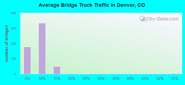
- 1,763,899Total average daily truck traffic
- National Bridge Inventory (NBI) Registered Bridges for Denver
- No street view available for this location
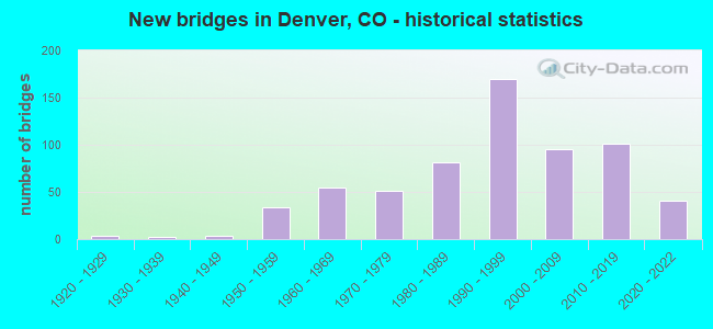
- New bridges - historical statistics
- 11910-1919
- 41920-1929
- 21930-1939
- 31940-1949
- 341950-1959
- 551960-1969
- 511970-1979
- 811980-1989
- 1701990-1999
- 952000-2009
- 1012010-2019
- 412020-2022
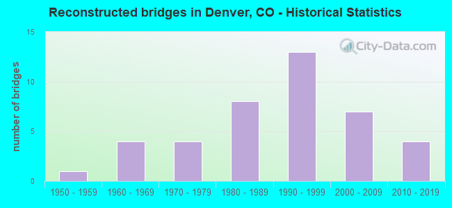
- Reconstructed bridges - Historical Statistics
- 11950-1959
- 41960-1969
- 41970-1979
- 81980-1989
- 131990-1999
- 72000-2009
- 42010-2019
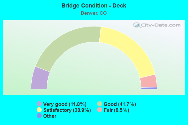
- Bridge Condition - Deck
- 11.8%Very good
- 41.7%Good
- 38.9%Satisfactory
- 6.5%Fair
- 1.0%Poor
- 0.3%Serious
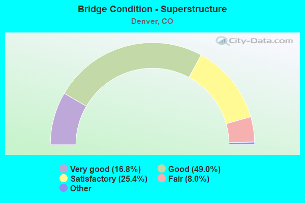
- Bridge Condition - Superstructure
- 16.8%Very good
- 49.0%Good
- 25.4%Satisfactory
- 8.0%Fair
- 0.8%Poor
- 0.3%Serious
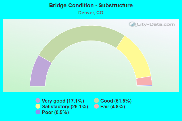
- Bridge Condition - Substructure
- 17.1%Very good
- 51.5%Good
- 26.1%Satisfactory
- 4.8%Fair
- 0.5%Poor
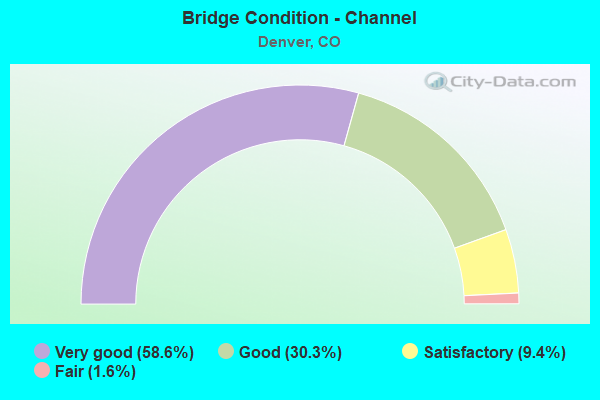
- Bridge Condition - Channel
- 58.6%Very good
- 30.3%Good
- 9.4%Satisfactory
- 1.6%Fair
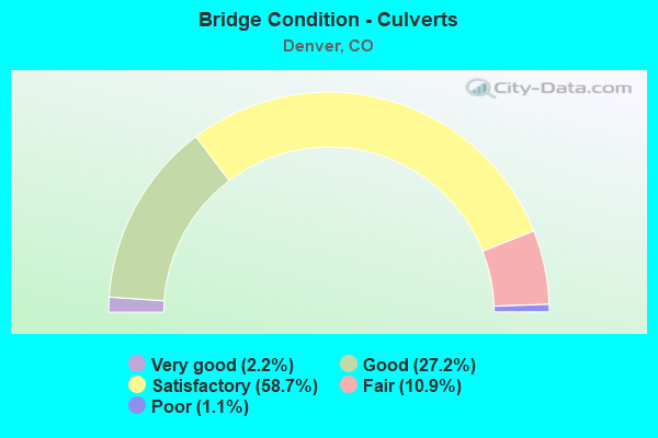
- Bridge Condition - Culverts
- 2.2%Very good
- 27.2%Good
- 58.7%Satisfactory
- 10.9%Fair
- 1.1%Poor
Find on map >> Show street view
Structure Number: D-20-MB-786, Location: JUST W. OF HAVANA ST (Lat: 39.798500, Lng: -104.866444), Route carried "on" structure: City street , Year Built: 2010, Status: Open, Structure Length: 1.58m (5.18ft), Average Daily Traffic: 17,679 (year 2021), Truck Traffic: 6%, Average Future Daily Traffic: 19,624 (year 2041), Design Load: HS 20, Features Intersected: MONTBELLO DITCH, Facility Carried by Structure: WESTBOUND 56TH AVE
Minimum Vertical Clearance: 30.45m (99.90ft), Kilometerpoint: 1.566, Lanes on structure: 2, Owner: City or Municipal Highway Agency, Approaching Roadway Width: 11.9m (39.0ft), Skew: 20 degrees, Material/Design: Prestressed concrete, Design/Construction: Box Beam or Girders - Single/Spread, Number Of Spans In Main Unit: 1, Length of Maximum Span: 14.0m (45.9ft), Curb or Sidewalk Widths: Left: 4.0m (13.1ft), Right: 0.8m (2.6ft), Curb-To-Curb Width: 11.9m (39.0ft), Out-to-Out Width: 17.1m (56.1ft)
Condition: Deck: Good, Superstructure: Very good, Substructure: Very good, Channel: Very good, Operating Rating: 53.0 metric tons, Method Used To Determine Operating Rating: Load and Resistance Factor (LRFR), Inventory Rating: 36.6 metric tons, Method Used To Determine Inventory Rating: Load and Resistance Factor (LRFR), Structural Evaluation: Equal to present desirable criteria, Deck Geometry: Better than present minimum criteria, Waterway Adequacy: Equal to present desirable criteria, Approach Roadway Alignment: Equal to present desirable criteria, Designated Inspection Frequency: Every 24 months, Inspection Date: October 2020, Deck Structure Type: Concrete Precast Panels, Wearing Surface/Protective System: Wearing Surface: Bituminous, Membrane: Built-up
Find on map >> Show street view
Structure Number: D-20-MB-79, Location: 0.5 MI W OF HAVANA ST (Lat: 39.798269, Lng: -104.878081), Route carried "on" structure: City street , Year Built: 1995, Status: Open, Structure Length: 3.11m (10.20ft), Average Daily Traffic: 19,982 (year 2021), Truck Traffic: 6%, Average Future Daily Traffic: 22,180 (year 2041), Features Intersected: PEDESTRIAN PATH, Facility Carried by Structure: EB 56TH AVE
Minimum Vertical Clearance: 30.45m (99.90ft), Kilometerpoint: 0.544, Lanes on structure: 3, Lanes under structure: 2, Owner: City or Municipal Highway Agency, Approaching Roadway Width: 12.8m (42.0ft), Material/Design: Prestressed concrete continuous, Design/Construction: Slab, Number Of Spans In Main Unit: 3, Length of Maximum Span: 15.2m (49.9ft), Curb-To-Curb Width: 13.7m (44.9ft), Out-to-Out Width: 14.6m (47.9ft)
Condition: Deck: Satisfactory, Superstructure: Satisfactory, Substructure: Satisfactory, Operating Rating: 81.4 metric tons, Method Used To Determine Operating Rating: Load Factor (LF), Inventory Rating: 42.8 metric tons, Method Used To Determine Inventory Rating: Load Factor (LF), Structural Evaluation: Equal to present minimum criteria, Deck Geometry: Somewhat better than minimum adequacy, Approach Roadway Alignment: Equal to present desirable criteria, Designated Inspection Frequency: Every 24 months, Inspection Date: December 2020, Deck Structure Type: Concrete Cast-file-Place, Wearing Surface/Protective System: Wearing Surface: Bituminous, Membrane: Built-up
Find on map >> Show street view
Structure Number: D-20-MB-792, Location: 0.5 MI W OF HAVANA ST (Lat: 39.798461, Lng: -104.878053), Route carried "on" structure: City street , Year Built: 2013, Status: Open, Structure Length: 3.20m (10.50ft), Average Daily Traffic: 22,176 (year 2021), Truck Traffic: 6%, Average Future Daily Traffic: 24,615 (year 2041), Features Intersected: PEDESTRIAN PATH, Facility Carried by Structure: WB 56TH AVE
Minimum Vertical Clearance: 30.45m (99.90ft), Kilometerpoint: 0.547, Lanes on structure: 3, Lanes under structure: 2, Owner: City or Municipal Highway Agency, Approaching Roadway Width: 11.9m (39.0ft), Material/Design: Prestressed concrete, Design/Construction: Stringer/Multi-beam, Number Of Spans In Main Unit: 1, Length of Maximum Span: 30.8m (101.0ft), Curb or Sidewalk Widths: Left: 3.4m (11.2ft), Right: 0.0m, Curb-To-Curb Width: 11.9m (39.0ft), Out-to-Out Width: 16.2m (53.1ft)
Condition: Deck: Very good, Superstructure: Good, Substructure: Good, Operating Rating: 66.3 metric tons, Method Used To Determine Operating Rating: Load and Resistance Factor (LRFR), Inventory Rating: 35.9 metric tons, Method Used To Determine Inventory Rating: Load and Resistance Factor (LRFR), Structural Evaluation: Better than present minimum criteria, Deck Geometry: High priority of corrective action, Approach Roadway Alignment: Equal to present desirable criteria, Designated Inspection Frequency: Every 24 months, Inspection Date: December 2020, Deck Structure Type: Concrete Precast Panels, Wearing Surface/Protective System: Wearing Surface: Bituminous, Membrane: Built-up, Deck Protection: Epoxy Coated Reinforcing
Find on map >> Show street view
Structure Number: D-21-WYC-02, Location: ALLEY E OF XANTHIA ST (Lat: 39.735556, Lng: -104.886536), Route carried "on" structure: City street , Year Built: 1983, Status: Open, Structure Length: 0.67m (2.20ft), Average Daily Traffic: 419 (year 2021), Truck Traffic: 2%, Average Future Daily Traffic: 465 (year 2041), Features Intersected: WESTERLY CREEK, Facility Carried by Structure: 12TH AVE
Minimum Vertical Clearance: 30+ m (98+ ft), Kilometerpoint: 2.166, Lanes on structure: 2, Owner: City or Municipal Highway Agency, Approaching Roadway Width: 11.0m (36.1ft), Skew: 4 degrees, Material/Design: Concrete, Design/Construction: Culvert, Number Of Spans In Main Unit: 2, Length of Maximum Span: 3.2m (10.5ft), Curb or Sidewalk Widths: Left: 1.4m (4.6ft), Right: 1.4m (4.6ft), Out-to-Out Width: 94.0m (308.4ft)
Condition: Channel: Satisfactory, Culverts: Good, Operating Rating: 36.3 metric tons, Method Used To Determine Operating Rating: Field evaluation and documented engineering judgment, Inventory Rating: 32.7 metric tons, Method Used To Determine Inventory Rating: Field evaluation and documented engineering judgment, Structural Evaluation: Better than present minimum criteria, Waterway Adequacy: Equal to present desirable criteria, Approach Roadway Alignment: Equal to present desirable criteria, Designated Inspection Frequency: Every 24 months, Inspection Date: November 2020
Find on map >> Show street view
Structure Number: D-21-WYC-03, Location: RICHTHOFEN AND XANTHIA (Lat: 39.734203, Lng: -104.886939), Route carried "on" structure: City street , Year Built: 1965, Status: Open, Structure Length: 0.63m (2.07ft), Average Daily Traffic: 334 (year 2021), Truck Traffic: 2%, Average Future Daily Traffic: 371 (year 2041), Features Intersected: WESTERLY CREEK, Facility Carried by Structure: RICHTHOFEN PLACE
Minimum Vertical Clearance: 30+ m (98+ ft), Kilometerpoint: 0.298, Lanes on structure: 2, Owner: City or Municipal Highway Agency, Approaching Roadway Width: 11.0m (36.1ft), Skew: 3 degrees, Material/Design: Concrete, Design/Construction: Culvert, Number Of Spans In Main Unit: 2, Length of Maximum Span: 3.0m (9.8ft), Curb or Sidewalk Widths: Left: 1.2m (3.9ft), Right: 1.2m (3.9ft), Curb-To-Curb Width: 11.0m (36.1ft), Out-to-Out Width: 26.7m (87.6ft)
Condition: Channel: Good, Culverts: Good, Operating Rating: 93.1 metric tons, Method Used To Determine Operating Rating: Load Factor (LF), Inventory Rating: 55.8 metric tons, Method Used To Determine Inventory Rating: Load Factor (LF), Structural Evaluation: Better than present minimum criteria, Deck Geometry: Equal to present desirable criteria, Waterway Adequacy: Equal to present desirable criteria, Approach Roadway Alignment: Equal to present desirable criteria, Designated Inspection Frequency: Every 24 months, Inspection Date: November 2020
Find on map >> Show street view
Structure Number: D-21-WYC-07, Location: JUST EAST OF BEELER ST (Lat: 39.754711, Lng: -104.879114), Route carried "on" structure: City street , Year Built: 2005, Status: Open, Structure Length: 4.04m (13.25ft), Average Daily Traffic: 2,690 (year 2021), Average Future Daily Traffic: 2,986 (year 2041), Design Load: HS 25 or greater, Features Intersected: WESTERLY CREEK, Facility Carried by Structure: 26TH AVENUE
Minimum Vertical Clearance: 30+ m (98+ ft), Kilometerpoint: 0.410, Lanes on structure: 2, Owner: City or Municipal Highway Agency, Approaching Roadway Width: 13.3m (43.6ft), Material/Design: Steel, Design/Construction: Stringer/Multi-beam, Number Of Spans In Main Unit: 1, Length of Maximum Span: 38.1m (125.0ft), Curb or Sidewalk Widths: Left: 2.4m (7.9ft), Right: 2.4m (7.9ft), Curb-To-Curb Width: 10.4m (34.1ft), Out-to-Out Width: 16.6m (54.5ft)
Condition: Deck: Good, Superstructure: Very good, Substructure: Good, Channel: Very good, Operating Rating: 55.2 metric tons, Method Used To Determine Operating Rating: Load Factor (LF), Inventory Rating: 33.1 metric tons, Method Used To Determine Inventory Rating: Load Factor (LF), Structural Evaluation: Better than present minimum criteria, Deck Geometry: Somewhat better than minimum adequacy, Waterway Adequacy: Equal to present desirable criteria, Approach Roadway Alignment: Equal to present desirable criteria, Designated Inspection Frequency: Every 24 months, Inspection Date: November 2020, Deck Structure Type: Concrete Precast Panels, Wearing Surface/Protective System: Wearing Surface: Bituminous, Membrane: Built-up, Deck Protection: Epoxy Coated Reinforcing
Find on map >> Show street view
Structure Number: D-21-WYC-08, Location: JUST E OF BEELER STREET (Lat: 39.760125, Lng: -104.877133), Route carried "on" structure: City street , Year Built: 2005, Status: Open, Structure Length: 8.00m (26.25ft), Average Daily Traffic: 11,347 (year 2021), Truck Traffic: 10%, Average Future Daily Traffic: 12,595 (year 2041), Design Load: HS 20, Features Intersected: WESTERLY CREEK, Facility Carried by Structure: WB MRTN LTHR KING
Minimum Vertical Clearance: 30+ m (98+ ft), Kilometerpoint: 6.939, Lanes on structure: 2, Owner: City or Municipal Highway Agency, Approaching Roadway Width: 7.6m (24.9ft), Skew: 10 degrees, Material/Design: Steel continuous, Design/Construction: Box Beam or Girders - Single/Spread, Number Of Spans In Main Unit: 3, Length of Maximum Span: 44.6m (146.3ft), Curb or Sidewalk Widths: Left: 3.0m (9.8ft), Right: 0.0m, Curb-To-Curb Width: 7.9m (25.9ft), Out-to-Out Width: 12.3m (40.4ft)
Condition: Deck: Good, Superstructure: Good, Substructure: Good, Channel: Very good, Operating Rating: 64.0 metric tons, Method Used To Determine Operating Rating: Load Factor (LF), Inventory Rating: 38.5 metric tons, Method Used To Determine Inventory Rating: Load Factor (LF), Structural Evaluation: Better than present minimum criteria, Deck Geometry: High priority of replacement, Waterway Adequacy: Equal to present desirable criteria, Approach Roadway Alignment: Equal to present desirable criteria, Designated Inspection Frequency: Every 24 months, Critical Feature Inspection Frequency: Every 24 months, Other Special Inspection Frequency: Every 60 months, Inspection Date: November 2021, Critical Feature Inspection Date: November 2020, Other Special Inspection Date: November 2021, Deck Structure Type: Concrete Cast-file-Place, Wearing Surface/Protective System: Wearing Surface: Bituminous, Membrane: Built-up, Deck Protection: Epoxy Coated Reinforcing
Find on map >> Show street view
Structure Number: D-21-WYC-081, Location: JUST E OF BEELER STREET (Lat: 39.759969, Lng: -104.877136), Route carried "on" structure: City street , Year Built: 2005, Status: Open, Structure Length: 8.00m (26.25ft), Average Daily Traffic: 9,627 (year 2021), Truck Traffic: 10%, Average Future Daily Traffic: 10,686 (year 2041), Design Load: HS 20, Features Intersected: WESTERLY CREEK, Facility Carried by Structure: EB MRTN LTHR KING
Minimum Vertical Clearance: 30+ m (98+ ft), Kilometerpoint: 6.939, Lanes on structure: 2, Owner: City or Municipal Highway Agency, Approaching Roadway Width: 7.6m (24.9ft), Skew: 10 degrees, Material/Design: Steel continuous, Design/Construction: Box Beam or Girders - Single/Spread, Number Of Spans In Main Unit: 3, Length of Maximum Span: 44.6m (146.3ft), Curb or Sidewalk Widths: Left: 0.0m, Right: 3.0m (9.8ft), Curb-To-Curb Width: 7.9m (25.9ft), Out-to-Out Width: 12.3m (40.4ft)
Condition: Deck: Good, Superstructure: Good, Substructure: Good, Channel: Very good, Operating Rating: 64.0 metric tons, Method Used To Determine Operating Rating: Load Factor (LF), Inventory Rating: 38.5 metric tons, Method Used To Determine Inventory Rating: Load Factor (LF), Structural Evaluation: Better than present minimum criteria, Deck Geometry: High priority of replacement, Waterway Adequacy: Equal to present desirable criteria, Approach Roadway Alignment: Equal to present desirable criteria, Designated Inspection Frequency: Every 24 months, Critical Feature Inspection Frequency: Every 24 months, Other Special Inspection Frequency: Every 60 months, Inspection Date: November 2021, Critical Feature Inspection Date: November 2020, Other Special Inspection Date: November 2021, Deck Structure Type: Concrete Cast-file-Place, Wearing Surface/Protective System: Wearing Surface: Bituminous, Membrane: Built-up, Deck Protection: Epoxy Coated Reinforcing
Find on map >> Show street view
Structure Number: D-25-FC-010A, Location: 0.1 MILE SOUTH OF 56TH AV (Lat: 39.795439, Lng: -104.772128), Route carried "on" structure: City street , Year Built: 2009, Status: Open, Structure Length: 2.29m (7.51ft), Average Daily Traffic: 21,155 (year 2021), Truck Traffic: 4%, Average Future Daily Traffic: 23,482 (year 2041), Design Load: HS 25 or greater, Features Intersected: FIRST CREEK, Facility Carried by Structure: TOWER ROAD
Minimum Vertical Clearance: 30.45m (99.90ft), Kilometerpoint: 2.162, Lanes on structure: 4, Owner: City or Municipal Highway Agency, Approaching Roadway Width: 15.7m (51.5ft), Skew: 20 degrees, Material/Design: Concrete, Design/Construction: Frame, Number Of Spans In Main Unit: 2, Length of Maximum Span: 12.9m (42.3ft), Curb or Sidewalk Widths: Left: 1.8m (5.9ft), Right: 1.8m (5.9ft), Curb-To-Curb Width: 15.7m (51.5ft), Out-to-Out Width: 32.7m (107.3ft)
Condition: Deck: Good, Superstructure: Good, Substructure: Very good, Channel: Very good, Operating Rating: 36.3 metric tons, Method Used To Determine Operating Rating: Field evaluation and documented engineering judgment, Inventory Rating: 32.7 metric tons, Method Used To Determine Inventory Rating: Field evaluation and documented engineering judgment, Structural Evaluation: Better than present minimum criteria, Deck Geometry: Meets minimum limits, Waterway Adequacy: Equal to present desirable criteria, Approach Roadway Alignment: Equal to present desirable criteria, Designated Inspection Frequency: Every 24 months, Inspection Date: December 2020, Deck Structure Type: Other, Wearing Surface/Protective System: Wearing Surface: Bituminous
Find on map >> Show street view
Structure Number: D-25-FC-018, Location: 0.2 MI WEST OF TOWER RD (Lat: 39.798342, Lng: -104.778128), Route carried "on" structure: City street , Year Built: 2015, Status: Open, Structure Length: 1.02m (3.35ft), Average Daily Traffic: 29,465 (year 2021), Average Future Daily Traffic: 32,706 (year 2041), Features Intersected: BIKE PATH AND OVFLW, Facility Carried by Structure: 56TH AVE.
Minimum Vertical Clearance: 30.45m (99.90ft), Kilometerpoint: 9.106, Lanes on structure: 4, Owner: City or Municipal Highway Agency, Approaching Roadway Width: 16.5m (54.1ft), Skew: 31 degrees, Material/Design: Concrete, Design/Construction: Culvert, Number Of Spans In Main Unit: 2, Length of Maximum Span: 5.0m (16.4ft), Curb or Sidewalk Widths: Left: 0.0m, Right: 3.0m (9.8ft), Curb-To-Curb Width: 16.5m (54.1ft), Out-to-Out Width: 36.1m (118.4ft)
Condition: Channel: Very good, Culverts: Good, Inventory Rating: 90.3 metric tons, Method Used To Determine Inventory Rating: Field evaluation and documented engineering judgment, Structural Evaluation: Better than present minimum criteria, Deck Geometry: Meets minimum limits, Waterway Adequacy: Equal to present desirable criteria, Approach Roadway Alignment: Equal to present desirable criteria, Designated Inspection Frequency: Every 24 months, Inspection Date: November 2020
Find on map >> Show street view
Structure Number: D-25-FC-020A, Location: .2 MILES WEST OF TOWER RD (Lat: 39.798289, Lng: -104.777758), Route carried "on" structure: City street , Year Built: 2000, Status: Open, Structure Length: 2.44m (8.01ft), Average Daily Traffic: 14,732 (year 2021), Truck Traffic: 2%, Average Future Daily Traffic: 16,353 (year 2041), Design Load: HS 25 or greater, Features Intersected: FIRST CREEK, Facility Carried by Structure: EB 56TH AVENUE
Minimum Vertical Clearance: 30+ m (98+ ft), Kilometerpoint: 9.136, Lanes on structure: 2, Owner: City or Municipal Highway Agency, Approaching Roadway Width: 8.2m (26.9ft), Skew: 1 degrees, Material/Design: Prestressed concrete, Design/Construction: Box Beam or Girders - Single/Spread, Number Of Spans In Main Unit: 1, Length of Maximum Span: 22.8m (74.8ft), Curb or Sidewalk Widths: Left: 0.0m, Right: 3.4m (11.2ft), Curb-To-Curb Width: 8.2m (26.9ft), Out-to-Out Width: 12.5m (41.0ft)
Condition: Deck: Good, Superstructure: Satisfactory, Substructure: Good, Channel: Good, Operating Rating: 74.6 metric tons, Method Used To Determine Operating Rating: Load Factor (LF), Inventory Rating: 42.5 metric tons, Method Used To Determine Inventory Rating: Load Factor (LF), Structural Evaluation: Equal to present minimum criteria, Deck Geometry: High priority of corrective action, Waterway Adequacy: Equal to present desirable criteria, Approach Roadway Alignment: Equal to present desirable criteria, Designated Inspection Frequency: Every 24 months, Inspection Date: November 2020, Deck Structure Type: Concrete Cast-file-Place, Wearing Surface/Protective System: Wearing Surface: Bituminous, Membrane: Built-up, Deck Protection: Epoxy Coated Reinforcing
Find on map >> Show street view
Structure Number: D-25-FC-025, Location: .2 MILES WEST OF TOWER RD (Lat: 39.798431, Lng: -104.777831), Route carried "on" structure: City street , Year Built: 2000, Status: Open, Structure Length: 2.44m (8.01ft), Average Daily Traffic: 14,732 (year 2021), Truck Traffic: 2%, Average Future Daily Traffic: 16,353 (year 2041), Design Load: HS 25 or greater, Features Intersected: FIRST CREEK, Facility Carried by Structure: WB 56TH AVENUE
Minimum Vertical Clearance: 30+ m (98+ ft), Kilometerpoint: 9.131, Lanes on structure: 2, Owner: City or Municipal Highway Agency, Approaching Roadway Width: 8.2m (26.9ft), Skew: 1 degrees, Material/Design: Prestressed concrete, Design/Construction: Box Beam or Girders - Single/Spread, Number Of Spans In Main Unit: 1, Length of Maximum Span: 22.8m (74.8ft), Curb or Sidewalk Widths: Left: 1.5m (4.9ft), Right: 0.0m, Curb-To-Curb Width: 8.2m (26.9ft), Out-to-Out Width: 10.4m (34.1ft)
Condition: Deck: Good, Superstructure: Satisfactory, Substructure: Good, Channel: Good, Operating Rating: 72.0 metric tons, Method Used To Determine Operating Rating: Load Factor (LF), Inventory Rating: 40.8 metric tons, Method Used To Determine Inventory Rating: Load Factor (LF), Structural Evaluation: Equal to present minimum criteria, Deck Geometry: High priority of corrective action, Waterway Adequacy: Equal to present desirable criteria, Approach Roadway Alignment: Equal to present desirable criteria, Designated Inspection Frequency: Every 24 months, Inspection Date: November 2020, Deck Structure Type: Concrete Cast-file-Place, Wearing Surface/Protective System: Wearing Surface: Bituminous, Membrane: Built-up, Deck Protection: Epoxy Coated Reinforcing
Find on map >> Show street view
Structure Number: D-25-FC-029, Location: JUST SOUTH OF 62ND AVENUE (Lat: 39.808739, Lng: -104.772131), Route carried "on" structure: City street , Year Built: 1999, Status: Open, Structure Length: 0.88m (2.89ft), Average Daily Traffic: 23,498 (year 2021), Truck Traffic: 2%, Average Future Daily Traffic: 26,083 (year 2041), Design Load: HS 20, Features Intersected: LOCAL DRAINAGE, Facility Carried by Structure: TOWER ROAD
Minimum Vertical Clearance: 30+ m (98+ ft), Kilometerpoint: 3.650, Lanes on structure: 4, Owner: City or Municipal Highway Agency, Approaching Roadway Width: 8.2m (26.9ft), Skew: 30 degrees, Material/Design: Concrete, Design/Construction: Culvert, Number Of Spans In Main Unit: 2, Length of Maximum Span: 4.3m (14.1ft), Curb or Sidewalk Widths: Left: 0.0m, Right: 2.4m (7.9ft), Curb-To-Curb Width: 8.2m (26.9ft), Out-to-Out Width: 49.7m (163.1ft)
Condition: Channel: Very good, Culverts: Satisfactory, Inventory Rating: 61.8 metric tons, Method Used To Determine Inventory Rating: Load Factor (LF), Structural Evaluation: Equal to present minimum criteria, Deck Geometry: High priority of replacement, Waterway Adequacy: Equal to present desirable criteria, Approach Roadway Alignment: Equal to present desirable criteria, Designated Inspection Frequency: Every 24 months, Inspection Date: November 2020
Find on map >> Show street view
Structure Number: D-25-FC-033, Location: SW OF PENA BLVD/TOWER RD (Lat: 39.831022, Lng: -104.774556), Route carried "on" structure: Ramp City street , Year Built: 1999, Status: Open, Structure Length: 0.83m (2.72ft), Average Daily Traffic: 7,303 (year 2021), Truck Traffic: 1%, Average Future Daily Traffic: 8,106 (year 2041), Design Load: HS 20, Features Intersected: SECOND CREEK TRIB, Facility Carried by Structure: OFF RAMP TO TOWER
Minimum Vertical Clearance: 30+ m (98+ ft), Kilometerpoint: 0.000, Lanes on structure: 1, Owner: City or Municipal Highway Agency, Approaching Roadway Width: 7.6m (24.9ft), Skew: 5 degrees, Material/Design: Concrete, Design/Construction: Culvert, Number Of Spans In Main Unit: 1, Length of Maximum Span: 8.3m (27.2ft), Out-to-Out Width: 17.3m (56.8ft)
Condition: Channel: Good, Culverts: Satisfactory, Inventory Rating: 65.4 metric tons, Method Used To Determine Inventory Rating: Load Factor (LF), Structural Evaluation: Equal to present minimum criteria, Waterway Adequacy: Equal to present desirable criteria, Approach Roadway Alignment: Equal to present desirable criteria, Designated Inspection Frequency: Every 24 months, Inspection Date: November 2020
Find on map >> Show street view
Structure Number: D-25-FC-035, Location: JUST N OF 53RD AVENUE (Lat: 39.792297, Lng: -104.762747), Route carried "on" structure: City street , Year Built: 2004, Status: Open, Structure Length: 1.10m (3.61ft), Average Daily Traffic: 3,975 (year 2021), Truck Traffic: 1%, Average Future Daily Traffic: 4,412 (year 2041), Design Load: HS 20+Mod, Features Intersected: FIRST CREEK, Facility Carried by Structure: DUNKIRK STREET
Minimum Vertical Clearance: 30+ m (98+ ft), Kilometerpoint: 0.221, Lanes on structure: 4, Owner: City or Municipal Highway Agency, Approaching Roadway Width: 16.5m (54.1ft), Skew: 30 degrees, Material/Design: Steel, Design/Construction: Culvert, Number Of Spans In Main Unit: 2, Length of Maximum Span: 4.7m (15.4ft), Curb or Sidewalk Widths: Left: 1.5m (4.9ft), Right: 3.0m (9.8ft), Out-to-Out Width: 48.9m (160.4ft)
Condition: Channel: Very good, Culverts: Fair, Structural Evaluation: Somewhat better than minimum adequacy, Waterway Adequacy: Equal to present desirable criteria, Approach Roadway Alignment: Equal to present desirable criteria, Designated Inspection Frequency: Every 24 months, Inspection Date: November 2020
Find on map >> Show street view
Structure Number: D-25-FC-04, Location: 0.3 MI WEST OF PICADILLY (Lat: 39.781725, Lng: -104.740322), Route carried "on" structure: City street , Year Built: 1990, Status: Open, Structure Length: 3.35m (10.99ft), Average Daily Traffic: 3,845 (year 2021), Average Future Daily Traffic: 4,268 (year 2041), Features Intersected: FIRST CREEK, Facility Carried by Structure: GRN VALLEY RNCH BL
Minimum Vertical Clearance: 30+ m (98+ ft), Kilometerpoint: 6.085, Lanes on structure: 4, Owner: City or Municipal Highway Agency, Approaching Roadway Width: 21.9m (71.9ft), Skew: 20 degrees, Material/Design: Steel, Design/Construction: Culvert, Number Of Spans In Main Unit: 4, Length of Maximum Span: 7.9m (25.9ft), Curb or Sidewalk Widths: Left: 3.4m (11.2ft), Right: 1.5m (4.9ft), Out-to-Out Width: 48.5m (159.1ft)
Condition: Channel: Good, Culverts: Fair, Structural Evaluation: Somewhat better than minimum adequacy, Waterway Adequacy: Equal to present desirable criteria, Approach Roadway Alignment: Equal to present desirable criteria, Designated Inspection Frequency: Every 24 months, Inspection Date: November 2020
Find on map >> Show street view
Structure Number: D-25-FC-045, Location: JUST S OF 50TH AVENUE (Lat: 39.784744, Lng: -104.737117), Route carried "on" structure: City street , Year Built: 2004, Status: Open, Structure Length: 3.23m (10.60ft), Average Daily Traffic: 3,087 (year 2021), Truck Traffic: 1%, Average Future Daily Traffic: 3,426 (year 2041), Design Load: HS 20, Features Intersected: FIRST CREEK, Facility Carried by Structure: ORLEANS STREET
Minimum Vertical Clearance: 30+ m (98+ ft), Kilometerpoint: 0.637, Lanes on structure: 2, Owner: City or Municipal Highway Agency, Approaching Roadway Width: 12.2m (40.0ft), Skew: 5 degrees, Material/Design: Concrete, Design/Construction: Culvert, Number Of Spans In Main Unit: 5, Length of Maximum Span: 6.2m (20.3ft), Curb or Sidewalk Widths: Left: 1.7m (5.6ft), Right: 1.7m (5.6ft), Curb-To-Curb Width: 12.3m (40.4ft), Out-to-Out Width: 21.1m (69.2ft)
Condition: Channel: Very good, Culverts: Satisfactory, Operating Rating: 85.9 metric tons, Method Used To Determine Operating Rating: Load Factor (LF), Inventory Rating: 51.5 metric tons, Method Used To Determine Inventory Rating: Load Factor (LF), Structural Evaluation: Equal to present minimum criteria, Deck Geometry: Equal to present minimum criteria, Waterway Adequacy: Equal to present desirable criteria, Approach Roadway Alignment: Equal to present desirable criteria, Designated Inspection Frequency: Every 24 months, Inspection Date: November 2020
Find on map >> Show street view
Structure Number: D-25-FC-055, Location: 0.1 MI W OF PICADILLY ST (Lat: 39.774869, Lng: -104.735711), Route carried "on" structure: City street , Year Built: 2005, Status: Open, Structure Length: 3.78m (12.40ft), Average Daily Traffic: 1,658 (year 2021), Truck Traffic: 1%, Average Future Daily Traffic: 1,841 (year 2041), Design Load: HS 20, Features Intersected: FIRST CREEK, Facility Carried by Structure: 42ND STREET
Minimum Vertical Clearance: 30.45m (99.90ft), Kilometerpoint: 1.632, Lanes on structure: 2, Owner: City or Municipal Highway Agency, Approaching Roadway Width: 13.4m (44.0ft), Skew: 3 degrees, Material/Design: Concrete, Design/Construction: Culvert, Number Of Spans In Main Unit: 10, Length of Maximum Span: 3.5m (11.5ft), Curb or Sidewalk Widths: Left: 1.7m (5.6ft), Right: 1.7m (5.6ft), Curb-To-Curb Width: 13.4m (44.0ft), Out-to-Out Width: 21.4m (70.2ft)
Condition: Channel: Very good, Culverts: Good, Operating Rating: 27.9 metric tons, Method Used To Determine Operating Rating: Load and Resistance Factor (LRFR), Inventory Rating: 21.5 metric tons, Method Used To Determine Inventory Rating: Load and Resistance Factor (LRFR), Structural Evaluation: Somewhat better than minimum adequacy, Deck Geometry: Equal to present desirable criteria, Waterway Adequacy: Equal to present desirable criteria, Approach Roadway Alignment: Better than present minimum criteria, Designated Inspection Frequency: Every 24 months, Inspection Date: November 2020
Find on map >> Show street view
Structure Number: D-26-SWG-005, Location: .35 MI W SHERIDAN BLVD (Lat: 39.638850, Lng: -105.060553), Route carried "on" structure: City street , Year Built: 1986, Status: Open, Structure Length: 0.91m (2.99ft), Average Daily Traffic: 11,115 (year 2021), Truck Traffic: 6%, Average Future Daily Traffic: 12,337 (year 2041), Design Load: HS 20, Features Intersected: SOUTHWESTERLY GULCHES, Facility Carried by Structure: QUINCY AVE
Minimum Vertical Clearance: 30+ m (98+ ft), Kilometerpoint: 2.278, Lanes on structure: 5, Owner: City or Municipal Highway Agency, Approaching Roadway Width: 18.0m (59.1ft), Skew: 4 degrees, Material/Design: Concrete, Design/Construction: Culvert, Number Of Spans In Main Unit: 2, Length of Maximum Span: 4.3m (14.1ft), Curb or Sidewalk Widths: Left: 3.0m (9.8ft), Right: 0.0m, Out-to-Out Width: 45.5m (149.3ft)
Condition: Channel: Very good, Culverts: Fair, Inventory Rating: 98.7 metric tons, Method Used To Determine Inventory Rating: Load Factor (LF), Structural Evaluation: Somewhat better than minimum adequacy, Waterway Adequacy: Equal to present desirable criteria, Approach Roadway Alignment: Equal to present desirable criteria, Designated Inspection Frequency: Every 24 months, Inspection Date: December 2020
Find on map >> Show street view
Structure Number: D-26-SWG-01, Location: BTWN WDSWRTH-MARSTON (Lat: 39.634083, Lng: -105.081669), Route carried "on" structure: City street , Year Built: 1968, Year Reconstructed: 1986, Status: Open, Structure Length: 0.73m (2.40ft), Average Daily Traffic: 2,450 (year 2021), Truck Traffic: 2%, Average Future Daily Traffic: 2,720 (year 2041), Features Intersected: SOUTHWESTERLY GULCHES, Facility Carried by Structure: OLD WADSWORTH BLVD
Minimum Vertical Clearance: 30+ m (98+ ft), Kilometerpoint: 0.121, Lanes on structure: 2, Owner: City or Municipal Highway Agency, Approaching Roadway Width: 8.2m (26.9ft), Material/Design: Concrete, Design/Construction: Culvert, Number Of Spans In Main Unit: 2, Length of Maximum Span: 3.5m (11.5ft), Curb or Sidewalk Widths: Left: 2.1m (6.9ft), Right: 1.7m (5.6ft), Curb-To-Curb Width: 13.5m (44.3ft), Out-to-Out Width: 25.4m (83.3ft)
Condition: Channel: Very good, Culverts: Satisfactory, Operating Rating: 36.3 metric tons, Method Used To Determine Operating Rating: Field evaluation and documented engineering judgment, Inventory Rating: 32.7 metric tons, Method Used To Determine Inventory Rating: Field evaluation and documented engineering judgment, Structural Evaluation: Equal to present minimum criteria, Deck Geometry: Superior to present desirable criteria, Waterway Adequacy: Equal to present desirable criteria, Approach Roadway Alignment: Equal to present desirable criteria, Designated Inspection Frequency: Every 24 months, Inspection Date: December 2020, Deck Structure Type: Concrete Cast-file-Place, Wearing Surface/Protective System: Wearing Surface: Bituminous
Find on map >> Show street view
Structure Number: D-26-SWG-015, Location: 1/2 MI S OF QUINCY AVE (Lat: 39.634592, Lng: -105.088722), Route carried "on" structure: City street , Year Built: 1985, Status: Open, Structure Length: 1.03m (3.38ft), Average Daily Traffic: 8,092 (year 2021), Truck Traffic: 2%, Average Future Daily Traffic: 8,983 (year 2041), Features Intersected: SOUTHWESTERLY GULCHES, Facility Carried by Structure: BALSAM ST
Minimum Vertical Clearance: 30+ m (98+ ft), Kilometerpoint: 0.200, Lanes on structure: 4, Owner: City or Municipal Highway Agency, Approaching Roadway Width: 16.5m (54.1ft), Skew: 26 degrees, Material/Design: Concrete, Design/Construction: Culvert, Number Of Spans In Main Unit: 2, Length of Maximum Span: 4.9m (16.1ft), Curb or Sidewalk Widths: Left: 1.5m (4.9ft), Right: 1.5m (4.9ft), Curb-To-Curb Width: 16.5m (54.1ft), Out-to-Out Width: 38.1m (125.0ft)
Condition: Channel: Very good, Culverts: Satisfactory, Operating Rating: 36.3 metric tons, Method Used To Determine Operating Rating: Field evaluation and documented engineering judgment, Inventory Rating: 32.7 metric tons, Method Used To Determine Inventory Rating: Field evaluation and documented engineering judgment, Structural Evaluation: Equal to present minimum criteria, Deck Geometry: Meets minimum limits, Waterway Adequacy: Equal to present desirable criteria, Approach Roadway Alignment: Equal to present desirable criteria, Designated Inspection Frequency: Every 24 months, Inspection Date: December 2020
Find on map >> Show street view
Structure Number: D-26-SWG-034, Location: 1/4 MI W OF WADSWORTH (Lat: 39.616958, Lng: -105.094331), Route carried "on" structure: City street , Year Built: 1985, Status: Open, Structure Length: 1.40m (4.59ft), Average Daily Traffic: 1,575 (year 2021), Truck Traffic: 4%, Average Future Daily Traffic: 1,748 (year 2041), Features Intersected: SOUTHWESTERLY GULCHES, Facility Carried by Structure: CRESTLINE AVE
Minimum Vertical Clearance: 30+ m (98+ ft), Kilometerpoint: 0.150, Lanes on structure: 2, Owner: City or Municipal Highway Agency, Approaching Roadway Width: 13.4m (44.0ft), Skew: 3 degrees, Material/Design: Concrete, Design/Construction: Culvert, Number Of Spans In Main Unit: 3, Length of Maximum Span: 5.2m (17.1ft), Curb or Sidewalk Widths: Left: 1.7m (5.6ft), Right: 1.7m (5.6ft), Curb-To-Curb Width: 13.4m (44.0ft), Out-to-Out Width: 25.5m (83.7ft)
Condition: Channel: Very good, Culverts: Satisfactory, Operating Rating: 36.3 metric tons, Method Used To Determine Operating Rating: Field evaluation and documented engineering judgment, Inventory Rating: 32.7 metric tons, Method Used To Determine Inventory Rating: Field evaluation and documented engineering judgment, Structural Evaluation: Equal to present minimum criteria, Deck Geometry: Equal to present desirable criteria, Waterway Adequacy: Equal to present desirable criteria, Approach Roadway Alignment: Equal to present desirable criteria, Designated Inspection Frequency: Every 24 months, Inspection Date: December 2020
Find on map >> Show street view
Structure Number: D-26-SWG-100A, Location: .35 MI N QUINCY AVENUE (Lat: 39.644061, Lng: -105.053247), Route carried "on" structure: City street , Year Built: 1996, Status: Open, Structure Length: 0.92m (3.02ft), Average Daily Traffic: 15,645 (year 2021), Truck Traffic: 6%, Average Future Daily Traffic: 17,366 (year 2041), Design Load: HS 20, Features Intersected: SOUTHWESTERLY GULCHES, Facility Carried by Structure: SHERIDAN BLVD
Minimum Vertical Clearance: 30+ m (98+ ft), Kilometerpoint: 0.866, Lanes on structure: 4, Owner: City or Municipal Highway Agency, Approaching Roadway Width: 14.7m (48.2ft), Skew: 20 degrees, Material/Design: Concrete, Design/Construction: Culvert, Number Of Spans In Main Unit: 3, Length of Maximum Span: 2.9m (9.5ft), Curb or Sidewalk Widths: Left: 2.6m (8.5ft), Right: 2.6m (8.5ft), Curb-To-Curb Width: 14.7m (48.2ft), Out-to-Out Width: 42.4m (139.1ft)
Condition: Channel: Good, Culverts: Good, Inventory Rating: 60.8 metric tons, Method Used To Determine Inventory Rating: Load Factor (LF), Structural Evaluation: Better than present minimum criteria, Deck Geometry: High priority of replacement, Waterway Adequacy: Equal to present desirable criteria, Approach Roadway Alignment: Equal to present desirable criteria, Designated Inspection Frequency: Every 24 months, Inspection Date: December 2020
Find on map >> Show street view
Structure Number: D-27-MP-010A, Location: SE ENTRANCE TO RED ROCKS (Lat: 39.671389, Lng: -105.194194), Route carried "on" structure: City street , Year Built: 2014, Status: Open, Structure Length: 2.01m (6.59ft), Average Daily Traffic: 2,257 (year 2021), Truck Traffic: 2%, Average Future Daily Traffic: 2,506 (year 2041), Design Load: HS 20, Features Intersected: MT VERNON CREEK, Facility Carried by Structure: RED ROCKS PARK RD
Minimum Vertical Clearance: 30.45m (99.90ft), Kilometerpoint: 2.779, Lanes on structure: 2, Owner: City or Municipal Highway Agency, Approaching Roadway Width: 6.1m (20.0ft), Material/Design: Steel, Design/Construction: Truss - Thru, Number Of Spans In Main Unit: 1, Length of Maximum Span: 19.8m (65.0ft), Curb or Sidewalk Widths: Left: 3.0m (9.8ft), Right: 0.0m, Curb-To-Curb Width: 7.3m (24.0ft), Out-to-Out Width: 11.1m (36.4ft)
Condition: Deck: Very good, Superstructure: Good, Substructure: Good, Channel: Very good, Operating Rating: 36.3 metric tons, Method Used To Determine Operating Rating: Field evaluation and documented engineering judgment, Inventory Rating: 32.7 metric tons, Method Used To Determine Inventory Rating: Field evaluation and documented engineering judgment, Structural Evaluation: Better than present minimum criteria, Deck Geometry: High priority of replacement, Waterway Adequacy: Equal to present desirable criteria, Approach Roadway Alignment: Equal to present desirable criteria, Designated Inspection Frequency: Every 24 months, Critical Feature Inspection Frequency: Every 24 months, Inspection Date: October 2020, Critical Feature Inspection Date: October 2020, Deck Structure Type: Concrete Cast-file-Place, Wearing Surface/Protective System: Wearing Surface: Bituminous
Find on map >> Show street view
Structure Number: D-27-MP-030A, Location: DENVER MT PARK OFFICE (Lat: 39.652900, Lng: -105.200297), Route carried "on" structure: City street , Year Built: 1999, Status: Open, Structure Length: 1.43m (4.69ft), Average Daily Traffic: 78 (year 2021), Average Future Daily Traffic: 86 (year 2041), Design Load: HS 20, Features Intersected: BEAR CREEK, Facility Carried by Structure: UNION AVENUE
Minimum Vertical Clearance: 30+ m (98+ ft), Kilometerpoint: 0.000, Lanes on structure: 1, Owner: City or Municipal Highway Agency, Approaching Roadway Width: 5.5m (18.0ft), Skew: 2 degrees, Material/Design: Wood or Timber, Design/Construction: Slab, Number Of Spans In Main Unit: 1, Length of Maximum Span: 11.7m (38.4ft), Curb-To-Curb Width: 4.4m (14.4ft), Out-to-Out Width: 4.8m (15.7ft)
Condition: Deck: Satisfactory, Superstructure: Satisfactory, Substructure: Satisfactory, Channel: Very good, Inventory Rating: 76.5 metric tons, Method Used To Determine Inventory Rating: Load Factor (LF), Structural Evaluation: Equal to present minimum criteria, Deck Geometry: Equal to present minimum criteria, Waterway Adequacy: Equal to present desirable criteria, Approach Roadway Alignment: Equal to present minimum criteria, Designated Inspection Frequency: Every 24 months, Inspection Date: November 2020, Deck Structure Type: Wood or Timber, Wearing Surface/Protective System: Wearing Surface: Bituminous
Find on map >> Show street view
Structure Number: D-27-MP-070A, Location: INLET TO EVERGREEN LAKE (Lat: 39.632744, Lng: -10.866836), Route carried "on" structure: City street , Year Built: 2020, Status: Open, Structure Length: 1.13m (3.71ft), Average Daily Traffic: 789 (year 2021), Average Future Daily Traffic: 876 (year 2041), Design Load: HL 93, Features Intersected: BEAR CREEK, Facility Carried by Structure: EVERGREEN LAKE RD
Minimum Vertical Clearance: 30+ m (98+ ft), Kilometerpoint: 0.000, Lanes on structure: 2, Owner: City or Municipal Highway Agency, Maintenance Responsibility: Local Park, Forest, or Reservation Agency, Approaching Roadway Width: 6.7m (22.0ft), Material/Design: Prestressed concrete, Design/Construction: Box Beam or Girders - Multiple, Number Of Spans In Main Unit: 1, Length of Maximum Span: 9.7m (31.8ft), Curb-To-Curb Width: 9.1m (29.9ft), Out-to-Out Width: 10.1m (33.1ft)
Condition: Deck: Very good, Superstructure: Very good, Substructure: Very good, Channel: Good, Operating Rating: 56.7 metric tons, Method Used To Determine Operating Rating: Load and Resistance Factor Rating (LRFR) rating reported by rating factor(RF) method using HL-93 loadings, Inventory Rating: 43.7 metric tons, Method Used To Determine Inventory Rating: Load and Resistance Factor Rating (LRFR) rating reported by rating factor(RF) method using HL-93 loadings, Structural Evaluation: Equal to present desirable criteria, Deck Geometry: Equal to present minimum criteria, Waterway Adequacy: Better than present minimum criteria, Approach Roadway Alignment: Equal to present desirable criteria, Designated Inspection Frequency: Every 24 months, Inspection Date: December 2020, Deck Structure Type: Concrete Cast-file-Place, Wearing Surface/Protective System: Wearing Surface: Bituminous
Find on map >> Show street view
Structure Number: D-27-MP-090A, Location: AT GOLF COURSE CLUB HOUSE (Lat: 39.633264, Lng: -105.335581), Route carried "on" structure: City street , Year Built: 2016, Status: Open, Structure Length: 0.98m (3.22ft), Average Daily Traffic: 19 (year 2021), Average Future Daily Traffic: 22 (year 2041), Features Intersected: BEAR CREEK, Facility Carried by Structure: GOLF COURSE RD
Minimum Vertical Clearance: 30+ m (98+ ft), Kilometerpoint: 0.000, Lanes on structure: 1, Owner: City or Municipal Highway Agency, Approaching Roadway Width: 4.7m (15.4ft), Material/Design: Prestressed concrete, Design/Construction: Slab, Number Of Spans In Main Unit: 1, Length of Maximum Span: 7.9m (25.9ft), Curb-To-Curb Width: 3.8m (12.5ft), Out-to-Out Width: 4.7m (15.4ft)
Condition: Deck: Very good, Superstructure: Very good, Substructure: Very good, Channel: Very good, Operating Rating: 55.1 metric tons, Method Used To Determine Operating Rating: Load and Resistance Factor Rating (LRFR) rating reported by rating factor(RF) method using HL-93 loadings, Inventory Rating: 42.1 metric tons, Method Used To Determine Inventory Rating: Load and Resistance Factor Rating (LRFR) rating reported by rating factor(RF) method using HL-93 loadings, Structural Evaluation: Equal to present desirable criteria, Deck Geometry: Meets minimum limits, Waterway Adequacy: Better than present minimum criteria, Approach Roadway Alignment: Equal to present minimum criteria, Designated Inspection Frequency: Every 24 months, Inspection Date: November 2020, Deck Structure Type: Concrete Cast-file-Place, Wearing Surface/Protective System: Wearing Surface: Bituminous
Find on map >> Show street view
Structure Number: D-27-MP-1, Location: 0.6 MI W OF SH 74 (Lat: 39.637917, Lng: -105.334003), Route carried "on" structure: City street , Year Built: 1970, Status: Open, Structure Length: 0.79m (2.59ft), Features Intersected: BEAR CREEK TRIB, Facility Carried by Structure: DEDISSE PARK RD
Minimum Vertical Clearance: 30+ m (98+ ft), Kilometerpoint: 0.793, Lanes on structure: 2, Owner: City or Municipal Highway Agency, Approaching Roadway Width: 5.8m (19.0ft), Skew: 3 degrees, Material/Design: Concrete, Design/Construction: Arch - Deck, Number Of Spans In Main Unit: 1, Length of Maximum Span: 7.3m (24.0ft), Curb-To-Curb Width: 6.0m (19.7ft), Out-to-Out Width: 7.0m (23.0ft)
Condition: Deck: Good, Superstructure: Good, Substructure: Satisfactory, Channel: Satisfactory, Operating Rating: 36.3 metric tons, Method Used To Determine Operating Rating: Field evaluation and documented engineering judgment, Inventory Rating: 32.7 metric tons, Method Used To Determine Inventory Rating: Field evaluation and documented engineering judgment, Structural Evaluation: Equal to present minimum criteria, Deck Geometry: Meets minimum limits, Waterway Adequacy: Equal to present desirable criteria, Approach Roadway Alignment: Equal to present desirable criteria, Designated Inspection Frequency: Every 24 months, Inspection Date: November 2020, Deck Structure Type: Concrete Cast-file-Place, Wearing Surface/Protective System: Wearing Surface: Gravel
Find on map >> Show street view
Structure Number: D-27-MP-110A, Location: O FALLON PARK (Lat: 39.654511, Lng: -105.288186), Route carried "on" structure: City street , Year Built: 2003, Status: Open, Structure Length: 1.39m (4.56ft), Average Daily Traffic: 8 (year 2021), Average Future Daily Traffic: 9 (year 2041), Design Load: HS 20, Features Intersected: BEAR CREEK, Facility Carried by Structure: O FALLON PARK
Minimum Vertical Clearance: 30+ m (98+ ft), Kilometerpoint: 0.719, Lanes on structure: 1, Owner: City or Municipal Highway Agency, Approaching Roadway Width: 5.5m (18.0ft), Material/Design: Concrete, Design/Construction: Arch - Deck, Number Of Spans In Main Unit: 1, Length of Maximum Span: 12.2m (40.0ft), Curb-To-Curb Width: 5.0m (16.4ft), Out-to-Out Width: 6.1m (20.0ft)
Condition: Deck: Good, Superstructure: Good, Substructure: Very good, Channel: Very good, Inventory Rating: 67.8 metric tons, Method Used To Determine Inventory Rating: Load Factor (LF), Structural Evaluation: Better than present minimum criteria, Deck Geometry: High priority of corrective action, Waterway Adequacy: Better than present minimum criteria, Approach Roadway Alignment: Equal to present minimum criteria, Designated Inspection Frequency: Every 24 months, Inspection Date: November 2020, Deck Structure Type: Other, Wearing Surface/Protective System: Wearing Surface: Other
Find on map >> Show street view
Structure Number: D-28-MS-06, Location: 0.1 MI W OF UNION STATION (Lat: 39.754281, Lng: -105.001447), Route carried "on" structure: City street , Year Built: 2012, Status: Open, Structure Length: 4.79m (15.72ft), Average Daily Traffic: 7,803 (year 2021), Average Future Daily Traffic: 8,661 (year 2041), Design Load: HS 20+Mod, Features Intersected: UNION STATION BUS DEPOT, Facility Carried by Structure: 17TH, CHESTNUT, WE
Minimum Vertical Clearance: 30.17m (98.98ft), Kilometerpoint: 0.555, Lanes on structure: 2, Owner: Local Agency, Approaching Roadway Width: 8.8m (28.9ft), Material/Design: Prestressed concrete, Design/Construction: Box Beam or Girders - Single/Spread, Number Of Spans In Main Unit: 4, Length of Maximum Span: 15.8m (51.8ft), Curb-To-Curb Width: 8.8m (28.9ft), Out-to-Out Width: 177.5m (582.3ft)
Condition: Deck: Good, Superstructure: Very good, Substructure: Good, Operating Rating: 40.6 metric tons, Method Used To Determine Operating Rating: Load and Resistance Factor (LRFR), Inventory Rating: 34.1 metric tons, Method Used To Determine Inventory Rating: Load and Resistance Factor (LRFR), Structural Evaluation: Better than present minimum criteria, Deck Geometry: High priority of replacement, Approach Roadway Alignment: Equal to present desirable criteria, Designated Inspection Frequency: Every 24 months, Inspection Date: January 2021, Deck Structure Type: Concrete Cast-file-Place, Wearing Surface/Protective System: Wearing Surface: Monolithic Concrete, Membrane: Built-up
Find on map >> Show street view
Structure Number: D-28-MS-13, Location: BETWEEN 16TH AND 17TH STR (Lat: 39.748594, Lng: -104.996497), Route carried "on" structure: City street , Year Built: 1984, Status: Open, Structure Length: 12.60m (41.34ft), Average Daily Traffic: 7,302 (year 2021), Truck Traffic: 8%, Average Future Daily Traffic: 8,105 (year 2041), Design Load: HS 20+Mod, Features Intersected: TABOR CNTR-PRKING GARAGE, Facility Carried by Structure: LAWRENCE STREET
Minimum Vertical Clearance: 5.27m (17.29ft), Kilometerpoint: 0.515, Lanes on structure: 4, Owner: Private, Approaching Roadway Width: 18.3m (60.0ft), Material/Design: Prestressed concrete, Design/Construction: Tee Beam, Number Of Spans In Main Unit: 15, Length of Maximum Span: 10.7m (35.1ft), Curb or Sidewalk Widths: Left: 3.0m (9.8ft), Right: 3.0m (9.8ft), Curb-To-Curb Width: 18.3m (60.0ft), Out-to-Out Width: 24.4m (80.1ft)
Condition: Deck: Good, Superstructure: Satisfactory, Substructure: Satisfactory, Operating Rating: 36.3 metric tons, Method Used To Determine Operating Rating: Field evaluation and documented engineering judgment, Inventory Rating: 32.7 metric tons, Method Used To Determine Inventory Rating: Field evaluation and documented engineering judgment, Structural Evaluation: Equal to present minimum criteria, Deck Geometry: Somewhat better than minimum adequacy, Approach Roadway Alignment: Equal to present desirable criteria, Designated Inspection Frequency: Every 24 months, Inspection Date: January 2021, Deck Structure Type: Concrete Cast-file-Place, Wearing Surface/Protective System: Wearing Surface: Bituminous, Membrane: Preformed Fabric
Find on map >> Show street view
Structure Number: D-28-MS-15, Location: NORTH OF 25TH AVENUE (Lat: 39.754161, Lng: -104.890433), Route carried "on" structure: City street , Year Built: 2004, Status: Open, Structure Length: 5.18m (16.99ft), Average Daily Traffic: 11,085 (year 2021), Truck Traffic: 2%, Average Future Daily Traffic: 12,305 (year 2041), Design Load: HS 25 or greater, Features Intersected: E-W LINEAR, Facility Carried by Structure: NB CENTRAL PK BLVD
Minimum Vertical Clearance: 30+ m (98+ ft), Kilometerpoint: 0.974, Lanes on structure: 2, Owner: City or Municipal Highway Agency, Approaching Roadway Width: 11.0m (36.1ft), Material/Design: Prestressed concrete continuous, Design/Construction: Box Beam or Girders - Multiple, Number Of Spans In Main Unit: 3, Length of Maximum Span: 36.3m (119.1ft), Curb or Sidewalk Widths: Left: 0.0m, Right: 2.7m (8.9ft), Curb-To-Curb Width: 9.3m (30.5ft), Out-to-Out Width: 12.7m (41.7ft)
Condition: Deck: Good, Superstructure: Very good, Substructure: Very good, Channel: Very good, Operating Rating: 60.8 metric tons, Method Used To Determine Operating Rating: Load Factor (LF), Inventory Rating: 36.5 metric tons, Method Used To Determine Inventory Rating: Load Factor (LF), Structural Evaluation: Equal to present desirable criteria, Deck Geometry: Meets minimum limits, Waterway Adequacy: Equal to present desirable criteria, Approach Roadway Alignment: Equal to present desirable criteria, Designated Inspection Frequency: Every 24 months, Inspection Date: November 2020, Deck Structure Type: Concrete Cast-file-Place, Wearing Surface/Protective System: Wearing Surface: Bituminous, Membrane: Built-up, Deck Protection: Epoxy Coated Reinforcing
Find on map >> Show street view
Structure Number: D-28-MS-155, Location: NORTH OF 25TH AVENUE (Lat: 39.754156, Lng: -104.890750), Route carried "on" structure: City street , Year Built: 2004, Status: Open, Structure Length: 5.18m (16.99ft), Average Daily Traffic: 8,390 (year 2021), Truck Traffic: 2%, Average Future Daily Traffic: 9,313 (year 2041), Design Load: HS 25 or greater, Features Intersected: E-W LINEAR, Facility Carried by Structure: SB CENTRAL PK BLVD
Minimum Vertical Clearance: 30+ m (98+ ft), Kilometerpoint: 0.973, Lanes on structure: 2, Owner: City or Municipal Highway Agency, Approaching Roadway Width: 11.0m (36.1ft), Skew: 10 degrees, Material/Design: Prestressed concrete continuous, Design/Construction: Box Beam or Girders - Multiple, Number Of Spans In Main Unit: 3, Length of Maximum Span: 36.3m (119.1ft), Curb or Sidewalk Widths: Left: 2.7m (8.9ft), Right: 0.0m, Curb-To-Curb Width: 9.3m (30.5ft), Out-to-Out Width: 12.7m (41.7ft)
Condition: Deck: Good, Superstructure: Very good, Substructure: Very good, Channel: Very good, Operating Rating: 60.8 metric tons, Method Used To Determine Operating Rating: Load Factor (LF), Inventory Rating: 36.5 metric tons, Method Used To Determine Inventory Rating: Load Factor (LF), Structural Evaluation: Equal to present desirable criteria, Deck Geometry: Meets minimum limits, Waterway Adequacy: Equal to present desirable criteria, Approach Roadway Alignment: Equal to present desirable criteria, Designated Inspection Frequency: Every 24 months, Inspection Date: November 2020, Deck Structure Type: Concrete Cast-file-Place, Wearing Surface/Protective System: Wearing Surface: Bituminous, Membrane: Built-up, Deck Protection: Epoxy Coated Reinforcing
Find on map >> Show street view
Structure Number: D-28-MS-2, Location: 0.25 MI S OF 56TH AVE (Lat: 39.794792, Lng: -104.883847), Route carried "on" structure: City street , Year Built: 2016, Status: Open, Structure Length: 0.91m (2.99ft), Average Daily Traffic: 14,076 (year 2021), Truck Traffic: 2%, Average Future Daily Traffic: 15,625 (year 2041), Features Intersected: LOCAL DRAINAGE, Facility Carried by Structure: CENTRAL PARK BLVD
Minimum Vertical Clearance: 30.45m (99.90ft), Kilometerpoint: 0.402, Lanes on structure: 4, Owner: City or Municipal Highway Agency, Approaching Roadway Width: 24.2m (79.4ft), Skew: 30 degrees, Material/Design: Concrete, Design/Construction: Culvert, Number Of Spans In Main Unit: 1, Length of Maximum Span: 9.1m (29.9ft), Curb or Sidewalk Widths: Left: 3.0m (9.8ft), Right: 3.1m (10.2ft), Curb-To-Curb Width: 24.2m (79.4ft), Out-to-Out Width: 40.8m (133.9ft)
Condition: Channel: Very good, Culverts: Very good, Operating Rating: 49.9 metric tons, Method Used To Determine Operating Rating: Load and Resistance Factor Rating (LRFR) rating reported by rating factor(RF) method using HL-93 loadings, Inventory Rating: 38.6 metric tons, Method Used To Determine Inventory Rating: Load and Resistance Factor Rating (LRFR) rating reported by rating factor(RF) method using HL-93 loadings, Structural Evaluation: Equal to present desirable criteria, Deck Geometry: Superior to present desirable criteria, Waterway Adequacy: Equal to present desirable criteria, Approach Roadway Alignment: Equal to present desirable criteria, Designated Inspection Frequency: Every 24 months, Inspection Date: November 2020
Find on map >> Show street view
Structure Number: D-28-MS-22, Location: 0.1 MI N OF 51ST AVE (Lat: 39.792986, Lng: -104.889822), Route carried "on" structure: City street , Year Built: 2015, Status: Open, Structure Length: 0.67m (2.20ft), Average Daily Traffic: 994 (year 2021), Truck Traffic: 2%, Average Future Daily Traffic: 1,103 (year 2041), Features Intersected: LOCAL DRAINAGE, Facility Carried by Structure: VERBENA STREET
Minimum Vertical Clearance: 30.45m (99.90ft), Kilometerpoint: 0.000, Lanes on structure: 2, Owner: City or Municipal Highway Agency, Approaching Roadway Width: 11.0m (36.1ft), Material/Design: Concrete, Design/Construction: Culvert, Number Of Spans In Main Unit: 2, Length of Maximum Span: 3.0m (9.8ft), Curb or Sidewalk Widths: Left: 1.5m (4.9ft), Right: 1.5m (4.9ft), Curb-To-Curb Width: 11.0m (36.1ft), Out-to-Out Width: 21.7m (71.2ft)
Condition: Channel: Satisfactory, Culverts: Good, Operating Rating: 54.4 metric tons, Method Used To Determine Operating Rating: Load and Resistance Factor (LRFR), Inventory Rating: 35.9 metric tons, Method Used To Determine Inventory Rating: Load and Resistance Factor (LRFR), Structural Evaluation: Better than present minimum criteria, Deck Geometry: Better than present minimum criteria, Waterway Adequacy: Equal to present desirable criteria, Approach Roadway Alignment: Equal to present desirable criteria, Designated Inspection Frequency: Every 24 months, Inspection Date: November 2020
Find on map >> Show street view
Structure Number: D-28-MS-24, Location: 0.11 MI N OF 51ST AVE (Lat: 39.793378, Lng: -104.893572), Route carried "on" structure: City street , Year Built: 2015, Status: Open, Structure Length: 0.66m (2.17ft), Average Daily Traffic: 1,415 (year 2021), Truck Traffic: 2%, Average Future Daily Traffic: 1,571 (year 2041), Features Intersected: LOCAL DRAINAGE, Facility Carried by Structure: UINTA STREET
Minimum Vertical Clearance: 30.45m (99.90ft), Kilometerpoint: 0.000, Lanes on structure: 2, Owner: City or Municipal Highway Agency, Approaching Roadway Width: 14.7m (48.2ft), Material/Design: Concrete, Design/Construction: Culvert, Number Of Spans In Main Unit: 2, Length of Maximum Span: 3.0m (9.8ft), Curb or Sidewalk Widths: Left: 1.5m (4.9ft), Right: 1.5m (4.9ft), Curb-To-Curb Width: 14.7m (48.2ft), Out-to-Out Width: 28.7m (94.2ft)
Condition: Channel: Very good, Culverts: Very good, Operating Rating: 42.1 metric tons, Method Used To Determine Operating Rating: Load and Resistance Factor Rating (LRFR) rating reported by rating factor(RF) method using HL-93 loadings, Inventory Rating: 32.4 metric tons, Method Used To Determine Inventory Rating: Load and Resistance Factor Rating (LRFR) rating reported by rating factor(RF) method using HL-93 loadings, Structural Evaluation: Equal to present desirable criteria, Deck Geometry: Superior to present desirable criteria, Waterway Adequacy: Equal to present desirable criteria, Approach Roadway Alignment: Equal to present desirable criteria, Designated Inspection Frequency: Every 24 months, Inspection Date: November 2020
Find on map >> Show street view
Structure Number: D-31-PB-1, Location: 0.75 MI NORTH OF I-70 (Lat: 39.778561, Lng: -104.791208), Route carried "on" structure: City street , Year Built: 1992, Status: Open, Structure Length: 0.80m (2.62ft), Average Daily Traffic: 61,445 (year 2021), Truck Traffic: 6%, Average Future Daily Traffic: 68,204 (year 2041), Design Load: HS 20, Features Intersected: LOCAL DRAINAGE, Facility Carried by Structure: SB PENA BLVD
Minimum Vertical Clearance: 30.45m (99.90ft), Kilometerpoint: 2.712, Lanes on structure: 3, Base Highway Network: Yes, Owner: Local Agency, Approaching Roadway Width: 15.2m (49.9ft), Skew: 1 degrees, Material/Design: Concrete, Design/Construction: Culvert, Number Of Spans In Main Unit: 3, Length of Maximum Span: 2.5m (8.2ft), Out-to-Out Width: 37.4m (122.7ft)
Condition: Channel: Satisfactory, Culverts: Satisfactory, Structural Evaluation: Equal to present minimum criteria, Waterway Adequacy: Equal to present desirable criteria, Approach Roadway Alignment: Equal to present desirable criteria, Designated Inspection Frequency: Every 24 months, Inspection Date: December 2020
Find on map >> Show street view
Structure Number: D-31-PB-11, Location: 0.75 MI NORTH OF I-70 (Lat: 39.778744, Lng: -104.790400), Route carried "on" structure: City street , Year Built: 1992, Status: Open, Structure Length: 0.80m (2.62ft), Average Daily Traffic: 61,445 (year 2021), Truck Traffic: 6%, Average Future Daily Traffic: 68,204 (year 2041), Design Load: HS 20, Features Intersected: LOCAL DRAINAGE, Facility Carried by Structure: NB PENA BLVD
Minimum Vertical Clearance: 30.45m (99.90ft), Kilometerpoint: 2.733, Lanes on structure: 3, Base Highway Network: Yes, Owner: Local Agency, Approaching Roadway Width: 15.2m (49.9ft), Skew: 1 degrees, Material/Design: Concrete, Design/Construction: Culvert, Number Of Spans In Main Unit: 3, Length of Maximum Span: 2.5m (8.2ft), Out-to-Out Width: 31.9m (104.7ft)
Condition: Channel: Good, Culverts: Satisfactory, Structural Evaluation: Equal to present minimum criteria, Waterway Adequacy: Equal to present desirable criteria, Approach Roadway Alignment: Equal to present desirable criteria, Designated Inspection Frequency: Every 24 months, Inspection Date: December 2020
Find on map >> Show street view
Structure Number: D-31-PB-15, Location: 1.0 MI NORTH OF I-70 (Lat: 39.783436, Lng: -104.791356), Route carried "on" structure: City street , Year Built: 1993, Status: Open, Structure Length: 6.90m (22.64ft), Average Daily Traffic: 61,445 (year 2021), Truck Traffic: 6%, Average Future Daily Traffic: 68,204 (year 2041), Design Load: HS 20, Features Intersected: GREEN VALLEY RANCH BLVD, Facility Carried by Structure: SB PENA BLVD
Minimum Vertical Clearance: 5.41m (17.75ft), Kilometerpoint: 1.580, Lanes on structure: 2, Lanes under structure: 5, Base Highway Network: Yes, Owner: Local Agency, Approaching Roadway Width: 12.2m (40.0ft), Material/Design: Prestressed concrete continuous, Design/Construction: Box Beam or Girders - Multiple, Number Of Spans In Main Unit: 2, Length of Maximum Span: 32.8m (107.6ft), Curb-To-Curb Width: 12.2m (40.0ft), Out-to-Out Width: 13.0m (42.7ft)
Condition: Deck: Satisfactory, Superstructure: Good, Substructure: Good, Operating Rating: 72.8 metric tons, Method Used To Determine Operating Rating: Load Factor (LF), Inventory Rating: 43.6 metric tons, Method Used To Determine Inventory Rating: Load Factor (LF), Structural Evaluation: Better than present minimum criteria, Deck Geometry: Better than present minimum criteria, Underclear: Superior to present desirable criteria, Approach Roadway Alignment: Equal to present desirable criteria, Designated Inspection Frequency: Every 24 months, Inspection Date: December 2020, Deck Structure Type: Concrete Cast-file-Place, Wearing Surface/Protective System: Wearing Surface: Monolithic Concrete, Deck Protection: Epoxy Coated Reinforcing
Find on map >> Show street view
Structure Number: D-31-PB-16, Location: 1.0 MI NORTH OF I-70 (Lat: 39.783433, Lng: -104.790450), Route carried "on" structure: City street , Year Built: 1993, Status: Open, Structure Length: 7.07m (23.20ft), Average Daily Traffic: 61,445 (year 2021), Truck Traffic: 6%, Average Future Daily Traffic: 68,204 (year 2041), Design Load: HS 20, Features Intersected: GREEN VALLEY RANCH BLVD, Facility Carried by Structure: NB PENA BLVD
Minimum Vertical Clearance: 5.41m (17.75ft), Kilometerpoint: 3.260, Lanes on structure: 2, Lanes under structure: 5, Base Highway Network: Yes, Owner: Local Agency, Approaching Roadway Width: 12.2m (40.0ft), Material/Design: Prestressed concrete continuous, Design/Construction: Box Beam or Girders - Multiple, Number Of Spans In Main Unit: 2, Length of Maximum Span: 34.7m (113.8ft), Curb-To-Curb Width: 12.2m (40.0ft), Out-to-Out Width: 13.0m (42.7ft)
Condition: Deck: Satisfactory, Superstructure: Good, Substructure: Good, Operating Rating: 82.4 metric tons, Method Used To Determine Operating Rating: Load Factor (LF), Inventory Rating: 49.3 metric tons, Method Used To Determine Inventory Rating: Load Factor (LF), Structural Evaluation: Better than present minimum criteria, Deck Geometry: Better than present minimum criteria, Underclear: Superior to present desirable criteria, Approach Roadway Alignment: Equal to present desirable criteria, Designated Inspection Frequency: Every 24 months, Inspection Date: December 2020, Deck Structure Type: Concrete Cast-file-Place, Wearing Surface/Protective System: Wearing Surface: Monolithic Concrete, Deck Protection: Epoxy Coated Reinforcing
Find on map >> Show street view
Structure Number: D-31-PB-2, Location: 1.5 MI NORTH OF I-70 (Lat: 39.798008, Lng: -104.787300), Route carried "on" structure: City street , Year Built: 1993, Status: Open, Structure Length: 6.98m (22.90ft), Average Daily Traffic: 54,351 (year 2021), Truck Traffic: 6%, Average Future Daily Traffic: 60,330 (year 2041), Design Load: HS 20, Features Intersected: 56TH AVENUE, Facility Carried by Structure: SB PENA BLVD
Minimum Vertical Clearance: 30.45m (99.90ft), Kilometerpoint: 8.320, Lanes on structure: 2, Lanes under structure: 6, Base Highway Network: Yes, Owner: Local Agency, Approaching Roadway Width: 12.2m (40.0ft), Material/Design: Prestressed concrete continuous, Design/Construction: Box Beam or Girders - Multiple, Number Of Spans In Main Unit: 2, Length of Maximum Span: 33.8m (110.9ft), Curb-To-Curb Width: 12.2m (40.0ft), Out-to-Out Width: 13.0m (42.7ft)
Condition: Deck: Satisfactory, Superstructure: Good, Substructure: Satisfactory, Operating Rating: 74.1 metric tons, Method Used To Determine Operating Rating: Load Factor (LF), Inventory Rating: 44.5 metric tons, Method Used To Determine Inventory Rating: Load Factor (LF), Structural Evaluation: Equal to present minimum criteria, Deck Geometry: Better than present minimum criteria, Underclear: Somewhat better than minimum adequacy, Approach Roadway Alignment: Equal to present desirable criteria, Designated Inspection Frequency: Every 24 months, Inspection Date: December 2020, Deck Structure Type: Concrete Cast-file-Place, Wearing Surface/Protective System: Wearing Surface: Monolithic Concrete, Deck Protection: Epoxy Coated Reinforcing
Find on map >> Show street view
Structure Number: D-31-PB-21, Location: 1.5 MI NORTH OF I-70 (Lat: 39.797997, Lng: -104.786400), Route carried "on" structure: City street , Year Built: 1993, Status: Open, Structure Length: 6.98m (22.90ft), Average Daily Traffic: 54,351 (year 2021), Truck Traffic: 6%, Average Future Daily Traffic: 60,330 (year 2041), Design Load: HS 20, Features Intersected: 56TH AVENUE, Facility Carried by Structure: NB PENA BLVD
Minimum Vertical Clearance: 30.45m (99.90ft), Kilometerpoint: 4.929, Lanes on structure: 2, Lanes under structure: 6, Base Highway Network: Yes, Owner: Local Agency, Approaching Roadway Width: 12.2m (40.0ft), Material/Design: Prestressed concrete continuous, Design/Construction: Box Beam or Girders - Multiple, Number Of Spans In Main Unit: 2, Length of Maximum Span: 33.8m (110.9ft), Curb-To-Curb Width: 12.2m (40.0ft), Out-to-Out Width: 13.0m (42.7ft)
Condition: Deck: Satisfactory, Superstructure: Good, Substructure: Satisfactory, Operating Rating: 74.1 metric tons, Method Used To Determine Operating Rating: Load Factor (LF), Inventory Rating: 44.5 metric tons, Method Used To Determine Inventory Rating: Load Factor (LF), Structural Evaluation: Equal to present minimum criteria, Deck Geometry: Better than present minimum criteria, Underclear: Equal to present minimum criteria, Approach Roadway Alignment: Equal to present desirable criteria, Designated Inspection Frequency: Every 24 months, Inspection Date: December 2020, Deck Structure Type: Concrete Cast-file-Place, Wearing Surface/Protective System: Wearing Surface: Monolithic Concrete, Deck Protection: Epoxy Coated Reinforcing