Bridge Statistics for Denver, Colorado (CO)
Condition, Traffic, Stress, Structural Evaluation, Project Costs
- National Bridge Inventory (NBI) Statistics
- 639Number of bridges
- 25,479ft / 7,766mTotal length
- $98,973,000Total costs
- 26,880,358Total average daily traffic
- 1,763,899Total average daily truck traffic
- National Bridge Inventory (NBI) Registered Bridges for Denver
- No street view available for this location
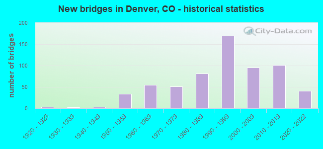
- New bridges - historical statistics
- 11910-1919
- 41920-1929
- 21930-1939
- 31940-1949
- 341950-1959
- 551960-1969
- 511970-1979
- 811980-1989
- 1701990-1999
- 952000-2009
- 1012010-2019
- 412020-2022
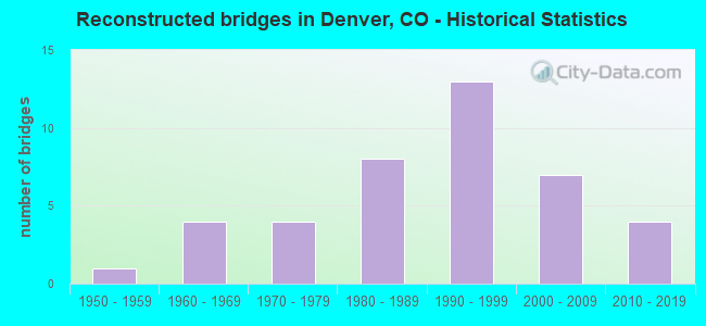
- Reconstructed bridges - Historical Statistics
- 11950-1959
- 41960-1969
- 41970-1979
- 81980-1989
- 131990-1999
- 72000-2009
- 42010-2019
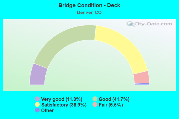
- Bridge Condition - Deck
- 11.8%Very good
- 41.7%Good
- 38.9%Satisfactory
- 6.5%Fair
- 1.0%Poor
- 0.3%Serious
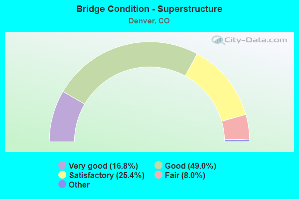
- Bridge Condition - Superstructure
- 16.8%Very good
- 49.0%Good
- 25.4%Satisfactory
- 8.0%Fair
- 0.8%Poor
- 0.3%Serious
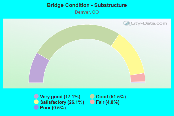
- Bridge Condition - Substructure
- 17.1%Very good
- 51.5%Good
- 26.1%Satisfactory
- 4.8%Fair
- 0.5%Poor
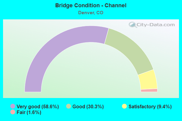
- Bridge Condition - Channel
- 58.6%Very good
- 30.3%Good
- 9.4%Satisfactory
- 1.6%Fair
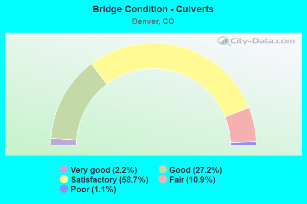
- Bridge Condition - Culverts
- 2.2%Very good
- 27.2%Good
- 58.7%Satisfactory
- 10.9%Fair
- 1.1%Poor
Find on map >> Show street view
Structure Number: D-10-HC-24, Location: YALE W OF QUEBEC ST (Lat: 39.667619, Lng: -104.904703), Route carried "on" structure: City street , Year Built: 1964, Status: Open, Structure Length: 1.40m (4.59ft), Average Daily Traffic: 12,726 (year 2021), Truck Traffic: 6%, Average Future Daily Traffic: 14,126 (year 2041), Features Intersected: HIGHLINE CANAL, Facility Carried by Structure: YALE AVE
Minimum Vertical Clearance: 30.45m (99.90ft), Kilometerpoint: 0.995, Lanes on structure: 2, Owner: City or Municipal Highway Agency, Approaching Roadway Width: 13.4m (44.0ft), Skew: 1 degrees, Material/Design: Prestressed concrete, Design/Construction: Tee Beam, Number Of Spans In Main Unit: 1, Length of Maximum Span: 12.8m (42.0ft), Curb or Sidewalk Widths: Left: 1.5m (4.9ft), Right: 1.5m (4.9ft), Curb-To-Curb Width: 13.4m (44.0ft), Out-to-Out Width: 17.1m (56.1ft)
Condition: Deck: Satisfactory, Superstructure: Satisfactory, Substructure: Good, Channel: Very good, Operating Rating: 33.4 metric tons, Method Used To Determine Operating Rating: Load Factor (LF), Inventory Rating: 16.8 metric tons, Method Used To Determine Inventory Rating: Load Factor (LF), Structural Evaluation: Meets minimum limits, Deck Geometry: Equal to present minimum criteria, Waterway Adequacy: Equal to present desirable criteria, Approach Roadway Alignment: Equal to present desirable criteria, Designated Inspection Frequency: Every 24 months, Inspection Date: December 2020, Deck Structure Type: Concrete Cast-file-Place, Wearing Surface/Protective System: Wearing Surface: Bituminous
Find on map >> Show street view
Structure Number: D-10-HC-261, Location: QUEBEC ST AT WESLEY AVE (Lat: 39.674511, Lng: -104.903622), Route carried "on" structure: City street , Year Built: 1981, Status: Open, Structure Length: 0.94m (3.08ft), Average Daily Traffic: 22,939 (year 2021), Truck Traffic: 6%, Average Future Daily Traffic: 25,462 (year 2041), Design Load: HS 20, Features Intersected: HIGHLINE CANAL, Facility Carried by Structure: QUEBEC ST
Minimum Vertical Clearance: 30.45m (99.90ft), Kilometerpoint: 0.246, Lanes on structure: 4, Owner: City or Municipal Highway Agency, Approaching Roadway Width: 18.3m (60.0ft), Skew: 21 degrees, Material/Design: Concrete, Design/Construction: Frame, Number Of Spans In Main Unit: 1, Length of Maximum Span: 8.5m (27.9ft), Curb or Sidewalk Widths: Left: 1.4m (4.6ft), Right: 1.4m (4.6ft), Curb-To-Curb Width: 18.3m (60.0ft), Out-to-Out Width: 26.7m (87.6ft)
Condition: Deck: Satisfactory, Superstructure: Satisfactory, Substructure: Good, Channel: Good, Operating Rating: 80.2 metric tons, Method Used To Determine Operating Rating: Load Factor (LF), Inventory Rating: 48.1 metric tons, Method Used To Determine Inventory Rating: Load Factor (LF), Structural Evaluation: Equal to present minimum criteria, Deck Geometry: Somewhat better than minimum adequacy, Waterway Adequacy: Equal to present desirable criteria, Approach Roadway Alignment: Equal to present desirable criteria, Designated Inspection Frequency: Every 24 months, Inspection Date: December 2020, Deck Structure Type: Concrete Cast-file-Place, Wearing Surface/Protective System: Wearing Surface: Bituminous
Find on map >> Show street view
Structure Number: D-10-HC-28, Location: .1 MI N OF CORNELL (Lat: 39.664228, Lng: -104.884625), Route carried "on" structure: City street , Year Built: 1979, Status: Open, Structure Length: 0.86m (2.82ft), Average Daily Traffic: 1,520 (year 2021), Truck Traffic: 5%, Average Future Daily Traffic: 1,687 (year 2041), Features Intersected: HIGHLINE CANAL, Facility Carried by Structure: YOSEMITE ST
Minimum Vertical Clearance: 30.45m (99.90ft), Kilometerpoint: 0.237, Lanes on structure: 2, Owner: City or Municipal Highway Agency, Approaching Roadway Width: 11.0m (36.1ft), Skew: 4 degrees, Material/Design: Concrete, Design/Construction: Culvert, Number Of Spans In Main Unit: 1, Length of Maximum Span: 8.6m (28.2ft), Curb or Sidewalk Widths: Left: 0.0m, Right: 4.6m (15.1ft), Curb-To-Curb Width: 31.4m (103.0ft), Out-to-Out Width: 32.0m (105.0ft)
Condition: Channel: Very good, Culverts: Satisfactory, Operating Rating: 55.3 metric tons, Method Used To Determine Operating Rating: Load Factor (LF), Inventory Rating: 33.2 metric tons, Method Used To Determine Inventory Rating: Load Factor (LF), Structural Evaluation: Equal to present minimum criteria, Deck Geometry: Superior to present desirable criteria, Waterway Adequacy: Equal to present desirable criteria, Approach Roadway Alignment: Equal to present desirable criteria, Designated Inspection Frequency: Every 24 months, Inspection Date: December 2020
Find on map >> Show street view
Structure Number: D-10-HC-29, Location: 0.1 MI NORTH OF CORNELL (Lat: 39.662553, Lng: -104.879950), Route carried "on" structure: City street , Year Built: 1983, Status: Open, Structure Length: 1.28m (4.20ft), Average Future Daily Traffic: 1 (year 2041), Features Intersected: HIGHLINE CANAL, Facility Carried by Structure: BOSTON ST
Minimum Vertical Clearance: 30.45m (99.90ft), Kilometerpoint: 0.000, Lanes on structure: 2, Owner: City or Municipal Highway Agency, Approaching Roadway Width: 7.8m (25.6ft), Material/Design: Steel, Design/Construction: Stringer/Multi-beam, Number Of Spans In Main Unit: 1, Length of Maximum Span: 9.8m (32.2ft), Curb or Sidewalk Widths: Left: 1.5m (4.9ft), Right: 0.0m, Curb-To-Curb Width: 7.6m (24.9ft), Out-to-Out Width: 9.4m (30.8ft)
Condition: Deck: Good, Superstructure: Good, Substructure: Satisfactory, Channel: Good, Operating Rating: 32.4 metric tons, Method Used To Determine Operating Rating: Load Factor (LF), Inventory Rating: 19.4 metric tons, Method Used To Determine Inventory Rating: Load Factor (LF), Structural Evaluation: Somewhat better than minimum adequacy, Deck Geometry: Equal to present minimum criteria, Waterway Adequacy: Equal to present desirable criteria, Approach Roadway Alignment: Better than present minimum criteria, Designated Inspection Frequency: Every 24 months, Inspection Date: December 2020, Deck Structure Type: Concrete Cast-file-Place, Wearing Surface/Protective System: Wearing Surface: Monolithic Concrete
Find on map >> Show street view
Structure Number: D-10-HC-295, Location: 0.3 MI W OF PARKER ROAD (Lat: 39.689339, Lng: -104.894581), Route carried "on" structure: City street , Year Built: 1994, Status: Open, Structure Length: 1.52m (4.99ft), Average Daily Traffic: 10,425 (year 2021), Truck Traffic: 4%, Average Future Daily Traffic: 11,572 (year 2041), Features Intersected: HIGHLINE CANAL, Facility Carried by Structure: FLORIDA AVENUE
Minimum Vertical Clearance: 30.45m (99.90ft), Kilometerpoint: 0.554, Lanes on structure: 2, Owner: City or Municipal Highway Agency, Approaching Roadway Width: 13.3m (43.6ft), Skew: 2 degrees, Material/Design: Concrete continuous, Design/Construction: Slab, Number Of Spans In Main Unit: 3, Length of Maximum Span: 8.8m (28.9ft), Curb or Sidewalk Widths: Left: 1.5m (4.9ft), Right: 0.3m (1.0ft), Curb-To-Curb Width: 6.7m (22.0ft), Out-to-Out Width: 9.1m (29.9ft)
Condition: Deck: Good, Superstructure: Good, Substructure: Satisfactory, Channel: Very good, Operating Rating: 45.4 metric tons, Method Used To Determine Operating Rating: Load Factor (LF), Inventory Rating: 26.9 metric tons, Method Used To Determine Inventory Rating: Load Factor (LF), Structural Evaluation: Equal to present minimum criteria, Deck Geometry: High priority of replacement, Waterway Adequacy: Equal to present desirable criteria, Approach Roadway Alignment: Equal to present minimum criteria, Length Of Structure Improvement: 1.52m (4.99ft), Designated Inspection Frequency: Every 24 months, Inspection Date: December 2020, Bridge Improvement Cost: $279,000, Roadway Improvement Cost: $28,000, Total Project Cost: $307,000 ( Estimate for 2014), Deck Structure Type: Concrete Cast-file-Place, Wearing Surface/Protective System: Wearing Surface: Bituminous, Membrane: Built-up, Deck Protection: Epoxy Coated Reinforcing
Find on map >> Show street view
Structure Number: D-10-HC-326, Location: .5 MI N MISSISSIPPI AVE (Lat: 39.704644, Lng: -104.890100), Route carried "on" structure: City street , Year Built: 1995, Year Reconstructed: 2012, Status: Open, Structure Length: 0.69m (2.26ft), Average Daily Traffic: 6,297 (year 2021), Truck Traffic: 4%, Average Future Daily Traffic: 6,989 (year 2041), Design Load: HS 20+Mod, Features Intersected: HIGHLINE CANAL, Facility Carried by Structure: VALENTIA ST
Minimum Vertical Clearance: 30.45m (99.90ft), Kilometerpoint: 0.111, Lanes on structure: 4, Owner: City or Municipal Highway Agency, Approaching Roadway Width: 16.5m (54.1ft), Skew: 1 degrees, Material/Design: Aluminum, Iron, Design/Construction: Culvert, Number Of Spans In Main Unit: 1, Length of Maximum Span: 6.1m (20.0ft), Curb or Sidewalk Widths: Left: 1.7m (5.6ft), Right: 1.7m (5.6ft), Curb-To-Curb Width: 16.5m (54.1ft), Out-to-Out Width: 20.5m (67.3ft)
Condition: Channel: Very good, Culverts: Good, Inventory Rating: 71.5 metric tons, Method Used To Determine Inventory Rating: Load Factor (LF), Structural Evaluation: Better than present minimum criteria, Deck Geometry: Meets minimum limits, Waterway Adequacy: Equal to present desirable criteria, Approach Roadway Alignment: Better than present minimum criteria, Designated Inspection Frequency: Every 24 months, Inspection Date: December 2020
Find on map >> Show street view
Structure Number: D-10-HC-33, Location: DAYTON AT E KENTUCKY RD (Lat: 39.700311, Lng: -104.875353), Route carried "on" structure: City street , Year Built: 1972, Status: Open, Structure Length: 1.01m (3.31ft), Average Daily Traffic: 10,288 (year 2021), Truck Traffic: 4%, Average Future Daily Traffic: 11,420 (year 2041), Features Intersected: HIGHLINE CANAL, Facility Carried by Structure: DAYTON ST
Minimum Vertical Clearance: 30.45m (99.90ft), Kilometerpoint: 0.966, Lanes on structure: 2, Owner: City or Municipal Highway Agency, Approaching Roadway Width: 13.4m (44.0ft), Material/Design: Prestressed concrete, Design/Construction: Tee Beam, Number Of Spans In Main Unit: 1, Length of Maximum Span: 9.1m (29.9ft), Curb or Sidewalk Widths: Left: 1.5m (4.9ft), Right: 1.5m (4.9ft), Curb-To-Curb Width: 13.4m (44.0ft), Out-to-Out Width: 17.1m (56.1ft)
Condition: Deck: Good, Superstructure: Satisfactory, Substructure: Good, Channel: Very good, Operating Rating: 36.9 metric tons, Method Used To Determine Operating Rating: Load Factor (LF), Inventory Rating: 22.1 metric tons, Method Used To Determine Inventory Rating: Load Factor (LF), Structural Evaluation: Somewhat better than minimum adequacy, Deck Geometry: Equal to present minimum criteria, Waterway Adequacy: Equal to present desirable criteria, Approach Roadway Alignment: Equal to present desirable criteria, Designated Inspection Frequency: Every 24 months, Inspection Date: December 2020, Deck Structure Type: Concrete Cast-file-Place, Wearing Surface/Protective System: Wearing Surface: Bituminous
Find on map >> Show street view
Structure Number: D-10-HC-38, Location: JUST N OF 53RD AVE (Lat: 39.793817, Lng: -104.796856), Route carried "on" structure: City street , Year Built: 2003, Status: Open, Structure Length: 1.69m (5.54ft), Average Daily Traffic: 2,821 (year 2021), Truck Traffic: 2%, Average Future Daily Traffic: 3,131 (year 2041), Design Load: HS 20, Features Intersected: IRONDALE GULCH, Facility Carried by Structure: MEMPHIS STREET
Minimum Vertical Clearance: 30.45m (99.90ft), Kilometerpoint: 1.654, Lanes on structure: 2, Owner: City or Municipal Highway Agency, Approaching Roadway Width: 16.5m (54.1ft), Material/Design: Concrete, Design/Construction: Culvert, Number Of Spans In Main Unit: 4, Length of Maximum Span: 4.0m (13.1ft), Curb or Sidewalk Widths: Left: 2.3m (7.5ft), Right: 2.3m (7.5ft), Curb-To-Curb Width: 16.5m (54.1ft), Out-to-Out Width: 21.7m (71.2ft)
Condition: Channel: Very good, Culverts: Satisfactory, Operating Rating: 52.5 metric tons, Method Used To Determine Operating Rating: Load Factor (LF), Inventory Rating: 31.5 metric tons, Method Used To Determine Inventory Rating: Load Factor (LF), Structural Evaluation: Equal to present minimum criteria, Deck Geometry: Superior to present desirable criteria, Waterway Adequacy: Equal to present desirable criteria, Approach Roadway Alignment: Equal to present desirable criteria, Designated Inspection Frequency: Every 24 months, Inspection Date: January 2021
Find on map >> Show street view
Structure Number: D-10-HC-39, Location: 0.2 MI EAST OF CHAMBERS (Lat: 39.794453, Lng: -104.804594), Route carried "on" structure: City street , Year Built: 2001, Status: Open, Structure Length: 0.63m (2.07ft), Average Daily Traffic: 1,198 (year 2021), Average Future Daily Traffic: 1,330 (year 2041), Features Intersected: IRONDALE GULCH, Facility Carried by Structure: MAXWELL PLACE
Minimum Vertical Clearance: 30.45m (99.90ft), Kilometerpoint: 2.842, Lanes on structure: 2, Owner: City or Municipal Highway Agency, Approaching Roadway Width: 13.4m (44.0ft), Material/Design: Concrete, Design/Construction: Culvert, Number Of Spans In Main Unit: 2, Length of Maximum Span: 3.0m (9.8ft), Curb or Sidewalk Widths: Left: 1.5m (4.9ft), Right: 2.4m (7.9ft), Out-to-Out Width: 30.5m (100.1ft)
Condition: Channel: Very good, Culverts: Satisfactory, Operating Rating: 36.3 metric tons, Method Used To Determine Operating Rating: Field evaluation and documented engineering judgment, Inventory Rating: 32.7 metric tons, Method Used To Determine Inventory Rating: Field evaluation and documented engineering judgment, Structural Evaluation: Equal to present minimum criteria, Waterway Adequacy: Equal to present desirable criteria, Approach Roadway Alignment: Equal to present desirable criteria, Designated Inspection Frequency: Every 24 months, Inspection Date: January 2021
Find on map >> Show street view
Structure Number: D-10-HC-395, Location: JUST EAST OF CHAMBERS RD (Lat: 39.798111, Lng: -104.807892), Route carried "on" structure: City street , Year Built: 2000, Status: Open, Structure Length: 1.93m (6.33ft), Average Daily Traffic: 17,525 (year 2021), Truck Traffic: 2%, Average Future Daily Traffic: 19,453 (year 2041), Design Load: HS 20, Features Intersected: IRONDALE GULCH, Facility Carried by Structure: 56TH AVENUE
Minimum Vertical Clearance: 30.45m (99.90ft), Kilometerpoint: 6.548, Lanes on structure: 2, Owner: City or Municipal Highway Agency, Approaching Roadway Width: 7.6m (24.9ft), Skew: 6 degrees, Material/Design: Concrete, Design/Construction: Culvert, Number Of Spans In Main Unit: 3, Length of Maximum Span: 6.1m (20.0ft), Curb or Sidewalk Widths: Left: 0.0m, Right: 3.0m (9.8ft), Out-to-Out Width: 58.8m (192.9ft)
Condition: Channel: Very good, Culverts: Satisfactory, Operating Rating: 75.0 metric tons, Method Used To Determine Operating Rating: Load Factor (LF), Inventory Rating: 45.0 metric tons, Method Used To Determine Inventory Rating: Load Factor (LF), Structural Evaluation: Equal to present minimum criteria, Waterway Adequacy: Equal to present desirable criteria, Approach Roadway Alignment: Equal to present desirable criteria, Designated Inspection Frequency: Every 24 months, Inspection Date: January 2021
Find on map >> Show street view
Structure Number: D-11-GG-005, Location: JUST E OF MONACO PKWY (Lat: 39.690419, Lng: -104.912386), Route carried "on" structure: City street , Year Built: 1995, Status: Open, Structure Length: 0.79m (2.59ft), Average Daily Traffic: 7,921 (year 2021), Truck Traffic: 2%, Average Future Daily Traffic: 8,792 (year 2041), Features Intersected: STORM DRAINAGE, Facility Carried by Structure: CHERRY CK DR
Minimum Vertical Clearance: 30.45m (99.90ft), Kilometerpoint: 0.035, Lanes on structure: 2, Owner: City or Municipal Highway Agency, Approaching Roadway Width: 9.8m (32.2ft), Material/Design: Concrete, Design/Construction: Culvert, Number Of Spans In Main Unit: 4, Length of Maximum Span: 1.5m (4.9ft), Curb or Sidewalk Widths: Left: 0.0m, Right: 3.7m (12.1ft), Out-to-Out Width: 21.9m (71.9ft)
Condition: Channel: Very good, Culverts: Good, Operating Rating: 36.3 metric tons, Method Used To Determine Operating Rating: Field evaluation and documented engineering judgment, Inventory Rating: 32.7 metric tons, Method Used To Determine Inventory Rating: Field evaluation and documented engineering judgment, Structural Evaluation: Better than present minimum criteria, Waterway Adequacy: Equal to present desirable criteria, Approach Roadway Alignment: Equal to present desirable criteria, Designated Inspection Frequency: Every 24 months, Inspection Date: January 2021
Find on map >> Show street view
Structure Number: D-11-GG-010A, Location: E OF MONACO PKWY (Lat: 39.689731, Lng: -104.911464), Route carried "on" structure: City street , Year Built: 1960, Year Reconstructed: 1995, Status: Open, Structure Length: 1.36m (4.46ft), Average Daily Traffic: 7,921 (year 2021), Truck Traffic: 6%, Average Future Daily Traffic: 8,792 (year 2041), Features Intersected: GOLDSMITH GULCH, Facility Carried by Structure: CHERRY CREEK DR
Minimum Vertical Clearance: 30.45m (99.90ft), Kilometerpoint: 0.140, Lanes on structure: 2, Owner: City or Municipal Highway Agency, Approaching Roadway Width: 9.8m (32.2ft), Material/Design: Steel, Design/Construction: Culvert, Number Of Spans In Main Unit: 3, Length of Maximum Span: 3.8m (12.5ft), Curb-To-Curb Width: 10.9m (35.8ft), Out-to-Out Width: 20.3m (66.6ft)
Condition: Channel: Very good, Culverts: Fair, Operating Rating: 88.3 metric tons, Method Used To Determine Operating Rating: Load Factor (LF), Inventory Rating: 53.0 metric tons, Method Used To Determine Inventory Rating: Load Factor (LF), Structural Evaluation: Somewhat better than minimum adequacy, Deck Geometry: Meets minimum limits, Waterway Adequacy: Equal to present desirable criteria, Approach Roadway Alignment: Equal to present desirable criteria, Designated Inspection Frequency: Every 24 months, Inspection Date: January 2021, Deck Structure Type: Concrete Cast-file-Place, Wearing Surface/Protective System: Wearing Surface: Monolithic Concrete
Find on map >> Show street view
Structure Number: D-11-GG-04, Location: E OF MONACO PKWY (Lat: 39.685717, Lng: -104.912178), Route carried "on" structure: City street , Year Built: 1966, Year Reconstructed: 1995, Status: Open, Structure Length: 1.01m (3.31ft), Average Daily Traffic: 1,158 (year 2021), Truck Traffic: 2%, Average Future Daily Traffic: 1,286 (year 2041), Features Intersected: GOLDSMITH GULCH, Facility Carried by Structure: MEXICO AVE
Minimum Vertical Clearance: 30.45m (99.90ft), Kilometerpoint: 0.871, Lanes on structure: 2, Owner: City or Municipal Highway Agency, Approaching Roadway Width: 11.0m (36.1ft), Material/Design: Concrete, Design/Construction: Culvert, Number Of Spans In Main Unit: 3, Length of Maximum Span: 3.0m (9.8ft), Curb or Sidewalk Widths: Left: 3.4m (11.2ft), Right: 3.4m (11.2ft), Curb-To-Curb Width: 11.0m (36.1ft), Out-to-Out Width: 18.5m (60.7ft)
Condition: Channel: Very good, Culverts: Satisfactory, Operating Rating: 49.9 metric tons, Method Used To Determine Operating Rating: Load Factor (LF), Inventory Rating: 29.9 metric tons, Method Used To Determine Inventory Rating: Load Factor (LF), Structural Evaluation: Equal to present minimum criteria, Deck Geometry: Equal to present minimum criteria, Waterway Adequacy: Equal to present desirable criteria, Approach Roadway Alignment: Equal to present desirable criteria, Designated Inspection Frequency: Every 24 months, Inspection Date: January 2021
Find on map >> Show street view
Structure Number: D-11-GG-050A, Location: AT COLO DR & JEWELL (Lat: 39.681997, Lng: -104.913250), Route carried "on" structure: City street , Year Built: 1965, Year Reconstructed: 1995, Status: Open, Structure Length: 1.36m (4.46ft), Average Daily Traffic: 15,005 (year 2021), Truck Traffic: 5%, Average Future Daily Traffic: 16,656 (year 2041), Features Intersected: GOLDSMITH GULCH, Facility Carried by Structure: MONACO PARKWAY
Minimum Vertical Clearance: 30.45m (99.90ft), Kilometerpoint: 0.203, Lanes on structure: 5, Base Highway Network: Yes, Owner: City or Municipal Highway Agency, Approaching Roadway Width: 16.5m (54.1ft), Skew: 9 degrees, Material/Design: Concrete, Design/Construction: Culvert, Number Of Spans In Main Unit: 3, Length of Maximum Span: 4.3m (14.1ft), Curb or Sidewalk Widths: Left: 1.7m (5.6ft), Right: 2.6m (8.5ft), Out-to-Out Width: 38.6m (126.6ft)
Condition: Channel: Very good, Culverts: Fair, Operating Rating: 55.5 metric tons, Method Used To Determine Operating Rating: Load Factor (LF), Inventory Rating: 33.2 metric tons, Method Used To Determine Inventory Rating: Load Factor (LF), Structural Evaluation: Somewhat better than minimum adequacy, Waterway Adequacy: Equal to present desirable criteria, Approach Roadway Alignment: Equal to present desirable criteria, Designated Inspection Frequency: Every 24 months, Inspection Date: January 2021
Find on map >> Show street view
Structure Number: D-11-GG-07, Location: JEWELL AT MONACO PKWY (Lat: 39.682086, Lng: -104.913339), Route carried "on" structure: City street , Year Built: 1972, Status: Open, Structure Length: 1.01m (3.31ft), Average Daily Traffic: 2,421 (year 2021), Truck Traffic: 4%, Average Future Daily Traffic: 2,687 (year 2041), Features Intersected: GOLDSMITH GULCH, Facility Carried by Structure: JEWELL AVENUE
Minimum Vertical Clearance: 30.45m (99.90ft), Kilometerpoint: 2.266, Lanes on structure: 2, Owner: City or Municipal Highway Agency, Approaching Roadway Width: 11.0m (36.1ft), Skew: 2 degrees, Material/Design: Concrete, Design/Construction: Culvert, Number Of Spans In Main Unit: 2, Length of Maximum Span: 4.9m (16.1ft), Curb or Sidewalk Widths: Left: 1.6m (5.2ft), Right: 1.6m (5.2ft), Curb-To-Curb Width: 12.2m (40.0ft), Out-to-Out Width: 15.9m (52.2ft)
Condition: Channel: Very good, Culverts: Good, Operating Rating: 48.4 metric tons, Method Used To Determine Operating Rating: Load Factor (LF), Inventory Rating: 29.0 metric tons, Method Used To Determine Inventory Rating: Load Factor (LF), Structural Evaluation: Better than present minimum criteria, Deck Geometry: Equal to present minimum criteria, Waterway Adequacy: Equal to present desirable criteria, Approach Roadway Alignment: Equal to present desirable criteria, Designated Inspection Frequency: Every 24 months, Inspection Date: January 2021
Find on map >> Show street view
Structure Number: D-11-GG-075, Location: JUST SO OF JEWELL AVE (Lat: 39.681497, Lng: -104.912703), Route carried "on" structure: City street , Year Built: 1996, Status: Open, Structure Length: 0.87m (2.85ft), Average Daily Traffic: 24,382 (year 2021), Truck Traffic: 5%, Average Future Daily Traffic: 27,064 (year 2041), Features Intersected: RETENTION POND DRAINAGE, Facility Carried by Structure: MONACO PARKWAY
Minimum Vertical Clearance: 30.45m (99.90ft), Kilometerpoint: 0.261, Lanes on structure: 6, Base Highway Network: Yes, Owner: City or Municipal Highway Agency, Approaching Roadway Width: 21.5m (70.5ft), Skew: 20 degrees, Material/Design: Concrete, Design/Construction: Culvert, Number Of Spans In Main Unit: 3, Length of Maximum Span: 2.4m (7.9ft), Curb or Sidewalk Widths: Left: 3.0m (9.8ft), Right: 4.9m (16.1ft), Curb-To-Curb Width: 21.5m (70.5ft), Out-to-Out Width: 32.4m (106.3ft)
Condition: Channel: Very good, Culverts: Satisfactory, Operating Rating: 47.6 metric tons, Method Used To Determine Operating Rating: Load Factor (LF), Inventory Rating: 28.5 metric tons, Method Used To Determine Inventory Rating: Load Factor (LF), Structural Evaluation: Equal to present minimum criteria, Deck Geometry: High priority of replacement, Waterway Adequacy: Equal to present desirable criteria, Approach Roadway Alignment: Equal to present desirable criteria, Designated Inspection Frequency: Every 24 months, Inspection Date: January 2021
Find on map >> Show street view
Structure Number: D-11-GG-08, Location: AT EVANS AVE (Lat: 39.679047, Lng: -104.913117), Route carried "on" structure: City street , Year Built: 1966, Status: Open, Structure Length: 1.36m (4.46ft), Average Daily Traffic: 26,351 (year 2021), Truck Traffic: 5%, Average Future Daily Traffic: 29,250 (year 2041), Features Intersected: GOLDSMITH GULCH, Facility Carried by Structure: MONACO PKWY
Minimum Vertical Clearance: 30.45m (99.90ft), Kilometerpoint: 0.538, Lanes on structure: 5, Base Highway Network: Yes, Owner: City or Municipal Highway Agency, Approaching Roadway Width: 17.4m (57.1ft), Skew: 4 degrees, Material/Design: Concrete, Design/Construction: Culvert, Number Of Spans In Main Unit: 2, Length of Maximum Span: 6.6m (21.7ft), Curb or Sidewalk Widths: Left: 2.6m (8.5ft), Right: 3.5m (11.5ft), Out-to-Out Width: 60.0m (196.9ft)
Condition: Channel: Good, Culverts: Fair, Operating Rating: 46.4 metric tons, Method Used To Determine Operating Rating: Load Factor (LF), Inventory Rating: 27.8 metric tons, Method Used To Determine Inventory Rating: Load Factor (LF), Structural Evaluation: Somewhat better than minimum adequacy, Waterway Adequacy: Better than present minimum criteria, Approach Roadway Alignment: Equal to present desirable criteria, Designated Inspection Frequency: Every 24 months, Inspection Date: January 2021
Find on map >> Show street view
Structure Number: D-11-GG-09, Location: E OF MONACO PKWY (Lat: 39.674731, Lng: -104.911133), Route carried "on" structure: City street , Year Built: 1971, Status: Open, Structure Length: 0.93m (3.05ft), Average Daily Traffic: 1,550 (year 2021), Truck Traffic: 2%, Average Future Daily Traffic: 1,720 (year 2041), Features Intersected: GOLDSMITH GULCH, Facility Carried by Structure: ILIFF AVE
Minimum Vertical Clearance: 30.45m (99.90ft), Kilometerpoint: 0.998, Lanes on structure: 2, Owner: City or Municipal Highway Agency, Approaching Roadway Width: 13.4m (44.0ft), Skew: 1 degrees, Material/Design: Concrete, Design/Construction: Culvert, Number Of Spans In Main Unit: 2, Length of Maximum Span: 4.5m (14.8ft), Curb or Sidewalk Widths: Left: 1.6m (5.2ft), Right: 1.2m (3.9ft), Out-to-Out Width: 23.5m (77.1ft)
Condition: Channel: Very good, Culverts: Good, Operating Rating: 87.0 metric tons, Method Used To Determine Operating Rating: Load Factor (LF), Inventory Rating: 52.1 metric tons, Method Used To Determine Inventory Rating: Load Factor (LF), Structural Evaluation: Better than present minimum criteria, Waterway Adequacy: Better than present minimum criteria, Approach Roadway Alignment: Equal to present desirable criteria, Designated Inspection Frequency: Every 24 months, Inspection Date: January 2021
Find on map >> Show street view
Structure Number: D-11-GG-100A, Location: AT ONEIDA STREET (Lat: 39.667631, Lng: -104.906150), Route carried "on" structure: City street , Year Built: 1995, Status: Open, Structure Length: 0.81m (2.66ft), Average Daily Traffic: 15,901 (year 2021), Truck Traffic: 6%, Average Future Daily Traffic: 17,650 (year 2041), Features Intersected: GOLDSMITH GULCH, Facility Carried by Structure: YALE AVE
Minimum Vertical Clearance: 30.45m (99.90ft), Kilometerpoint: 0.864, Lanes on structure: 2, Owner: City or Municipal Highway Agency, Approaching Roadway Width: 13.3m (43.6ft), Skew: 3 degrees, Material/Design: Concrete, Design/Construction: Culvert, Number Of Spans In Main Unit: 2, Length of Maximum Span: 5.3m (17.4ft), Curb or Sidewalk Widths: Left: 3.6m (11.8ft), Right: 3.1m (10.2ft), Curb-To-Curb Width: 13.3m (43.6ft), Out-to-Out Width: 33.5m (109.9ft)
Condition: Channel: Good, Culverts: Satisfactory, Operating Rating: 88.7 metric tons, Method Used To Determine Operating Rating: Load Factor (LF), Inventory Rating: 53.2 metric tons, Method Used To Determine Inventory Rating: Load Factor (LF), Structural Evaluation: Equal to present minimum criteria, Deck Geometry: Somewhat better than minimum adequacy, Waterway Adequacy: Equal to present desirable criteria, Approach Roadway Alignment: Equal to present desirable criteria, Designated Inspection Frequency: Every 24 months, Inspection Date: December 2020
Find on map >> Show street view
Structure Number: D-11-GG-120A, Location: JUST W OF TAMARAC DRIVE (Lat: 39.660358, Lng: -104.904086), Route carried "on" structure: City street , Year Built: 1971, Year Reconstructed: 1996, Status: Open, Structure Length: 2.16m (7.09ft), Average Daily Traffic: 2,767 (year 2021), Truck Traffic: 4%, Average Future Daily Traffic: 3,072 (year 2041), Design Load: HS 20, Features Intersected: GOLDSMITH GULCH, Facility Carried by Structure: CORNELL AVENUE
Minimum Vertical Clearance: 30.45m (99.90ft), Kilometerpoint: 0.824, Lanes on structure: 2, Owner: City or Municipal Highway Agency, Approaching Roadway Width: 8.7m (28.5ft), Material/Design: Concrete, Design/Construction: Culvert, Number Of Spans In Main Unit: 5, Length of Maximum Span: 4.3m (14.1ft), Curb or Sidewalk Widths: Left: 2.7m (8.9ft), Right: 0.0m, Out-to-Out Width: 56.7m (186.0ft)
Condition: Channel: Fair, Culverts: Fair, Operating Rating: 47.3 metric tons, Method Used To Determine Operating Rating: Load Factor (LF), Inventory Rating: 28.3 metric tons, Method Used To Determine Inventory Rating: Load Factor (LF), Structural Evaluation: Somewhat better than minimum adequacy, Waterway Adequacy: Better than present minimum criteria, Approach Roadway Alignment: Equal to present desirable criteria, Designated Inspection Frequency: Every 24 months, Inspection Date: December 2020
Find on map >> Show street view
Structure Number: D-11-GG-13, Location: JUST W OF TAMARAC DR (Lat: 39.656714, Lng: -104.902428), Route carried "on" structure: City street , Year Built: 1978, Status: Open, Structure Length: 1.46m (4.79ft), Average Daily Traffic: 3,301 (year 2021), Truck Traffic: 2%, Average Future Daily Traffic: 3,665 (year 2041), Features Intersected: GOLDSMITH GULCH, Facility Carried by Structure: EASTMAN AVENUE
Minimum Vertical Clearance: 30.45m (99.90ft), Kilometerpoint: 0.185, Lanes on structure: 2, Owner: City or Municipal Highway Agency, Approaching Roadway Width: 13.4m (44.0ft), Skew: 1 degrees, Material/Design: Concrete, Design/Construction: Culvert, Number Of Spans In Main Unit: 4, Length of Maximum Span: 3.8m (12.5ft), Curb or Sidewalk Widths: Left: 1.6m (5.2ft), Right: 1.6m (5.2ft), Curb-To-Curb Width: 13.4m (44.0ft), Out-to-Out Width: 21.4m (70.2ft)
Condition: Channel: Good, Culverts: Satisfactory, Operating Rating: 36.3 metric tons, Method Used To Determine Operating Rating: Field evaluation and documented engineering judgment, Inventory Rating: 27.9 metric tons, Method Used To Determine Inventory Rating: Load Factor (LF), Structural Evaluation: Equal to present minimum criteria, Deck Geometry: Better than present minimum criteria, Waterway Adequacy: Equal to present desirable criteria, Approach Roadway Alignment: Equal to present desirable criteria, Designated Inspection Frequency: Every 24 months, Inspection Date: December 2020
Find on map >> Show street view
Structure Number: D-11-GG-170A, Location: JUST W OF TAMARAC DRIVE (Lat: 39.649000, Lng: -104.898139), Route carried "on" structure: City street , Year Built: 1985, Status: Open, Structure Length: 1.03m (3.38ft), Average Daily Traffic: 2,030 (year 2021), Truck Traffic: 2%, Average Future Daily Traffic: 2,253 (year 2041), Features Intersected: GOLDSMITH GULCH, Facility Carried by Structure: ROSEMARY WAY
Minimum Vertical Clearance: 30.45m (99.90ft), Kilometerpoint: 0.052, Lanes on structure: 2, Owner: City or Municipal Highway Agency, Approaching Roadway Width: 13.4m (44.0ft), Material/Design: Concrete, Design/Construction: Culvert, Number Of Spans In Main Unit: 2, Length of Maximum Span: 5.0m (16.4ft), Curb or Sidewalk Widths: Left: 1.6m (5.2ft), Right: 1.6m (5.2ft), Curb-To-Curb Width: 13.4m (44.0ft), Out-to-Out Width: 17.5m (57.4ft)
Condition: Channel: Good, Culverts: Satisfactory, Operating Rating: 36.3 metric tons, Method Used To Determine Operating Rating: Field evaluation and documented engineering judgment, Inventory Rating: 32.7 metric tons, Method Used To Determine Inventory Rating: Field evaluation and documented engineering judgment, Structural Evaluation: Equal to present minimum criteria, Deck Geometry: Better than present minimum criteria, Waterway Adequacy: Equal to present desirable criteria, Approach Roadway Alignment: Equal to present desirable criteria, Designated Inspection Frequency: Every 24 months, Inspection Date: December 2020
Find on map >> Show street view
Structure Number: D-11-GG-180A, Location: W OF TAMARAC DRIVE (Lat: 39.643303, Lng: -104.894169), Route carried "on" structure: City street , Year Built: 1985, Status: Open, Structure Length: 1.02m (3.35ft), Average Daily Traffic: 2,176 (year 2021), Truck Traffic: 2%, Average Future Daily Traffic: 2,415 (year 2041), Features Intersected: GOLDSMITH GULCH, Facility Carried by Structure: PRINCETON AVE
Minimum Vertical Clearance: 30.45m (99.90ft), Kilometerpoint: 1.344, Lanes on structure: 2, Owner: City or Municipal Highway Agency, Approaching Roadway Width: 14.0m (45.9ft), Material/Design: Concrete, Design/Construction: Culvert, Number Of Spans In Main Unit: 2, Length of Maximum Span: 5.0m (16.4ft), Curb or Sidewalk Widths: Left: 1.9m (6.2ft), Right: 2.4m (7.9ft), Curb-To-Curb Width: 13.7m (44.9ft), Out-to-Out Width: 19.3m (63.3ft)
Condition: Channel: Fair, Culverts: Satisfactory, Operating Rating: 36.3 metric tons, Method Used To Determine Operating Rating: Field evaluation and documented engineering judgment, Inventory Rating: 32.7 metric tons, Method Used To Determine Inventory Rating: Field evaluation and documented engineering judgment, Structural Evaluation: Equal to present minimum criteria, Deck Geometry: Superior to present desirable criteria, Waterway Adequacy: Equal to present desirable criteria, Approach Roadway Alignment: Equal to present desirable criteria, Designated Inspection Frequency: Every 24 months, Inspection Date: December 2020
Find on map >> Show street view
Structure Number: D-11-GG-19, Location: JUST NE OF TAMARAC STREET (Lat: 39.638669, Lng: -104.894042), Route carried "on" structure: City street , Year Built: 1972, Status: Open, Structure Length: 0.91m (2.99ft), Average Daily Traffic: 10,760 (year 2021), Truck Traffic: 6%, Average Future Daily Traffic: 11,944 (year 2041), Design Load: HS 20+Mod, Features Intersected: GOLDSMITH GULCH, Facility Carried by Structure: QUINCY AVE
Minimum Vertical Clearance: 30+ m (98+ ft), Kilometerpoint: 1.646, Lanes on structure: 2, Owner: City or Municipal Highway Agency, Approaching Roadway Width: 17.3m (56.8ft), Material/Design: Steel, Design/Construction: Culvert, Number Of Spans In Main Unit: 2, Length of Maximum Span: 3.9m (12.8ft), Curb or Sidewalk Widths: Left: 3.4m (11.2ft), Right: 0.6m (2.0ft), Curb-To-Curb Width: 17.3m (56.8ft), Out-to-Out Width: 39.9m (130.9ft)
Condition: Channel: Very good, Culverts: Satisfactory, Structural Evaluation: Equal to present minimum criteria, Deck Geometry: Superior to present desirable criteria, Waterway Adequacy: Equal to present desirable criteria, Approach Roadway Alignment: Equal to present desirable criteria, Designated Inspection Frequency: Every 24 months, Inspection Date: September 2021
Find on map >> Show street view
Structure Number: D-11-GG-2, Location: JUST E OF DTC BLVD (Lat: 39.624100, Lng: -104.889050), Route carried "on" structure: City street , Year Built: 1986, Status: Open, Structure Length: 1.94m (6.36ft), Average Daily Traffic: 20,376 (year 2021), Truck Traffic: 5%, Average Future Daily Traffic: 22,617 (year 2041), Design Load: HS 20, Features Intersected: GOLDSMITH GULCH, Facility Carried by Structure: BELLEVIEW AVE
Minimum Vertical Clearance: 30+ m (98+ ft), Kilometerpoint: 1.144, Lanes on structure: 8, Owner: City or Municipal Highway Agency, Approaching Roadway Width: 28.7m (94.2ft), Skew: 32 degrees, Material/Design: Concrete, Design/Construction: Frame, Number Of Spans In Main Unit: 1, Length of Maximum Span: 18.2m (59.7ft), Curb or Sidewalk Widths: Left: 3.2m (10.5ft), Right: 3.2m (10.5ft), Curb-To-Curb Width: 28.7m (94.2ft), Out-to-Out Width: 39.1m (128.3ft)
Condition: Deck: Satisfactory, Superstructure: Satisfactory, Substructure: Good, Channel: Very good, Operating Rating: 98.1 metric tons, Method Used To Determine Operating Rating: Load Factor (LF), Inventory Rating: 58.8 metric tons, Method Used To Determine Inventory Rating: Load Factor (LF), Structural Evaluation: Equal to present minimum criteria, Deck Geometry: High priority of corrective action, Waterway Adequacy: Equal to present desirable criteria, Approach Roadway Alignment: Equal to present desirable criteria, Length Of Structure Improvement: 1.94m (6.36ft), Designated Inspection Frequency: Every 24 months, Inspection Date: December 2020, Bridge Improvement Cost: $618,000, Roadway Improvement Cost: $62,000, Total Project Cost: $679,000 ( Estimate for 2014), Deck Structure Type: Concrete Cast-file-Place, Wearing Surface/Protective System: Wearing Surface: Bituminous, Membrane: Built-up
Find on map >> Show street view
Structure Number: D-12-S, Location: 19.2 MI E OF JCT SH 9 (Lat: 40.084389, Lng: -106.077983), Route carried "on" structure: US 40A, Year Built: 1987, Status: Open, Structure Length: 7.67m (25.16ft), Average Daily Traffic: 3,400 (year 2020), Truck Traffic: 7%, Average Future Daily Traffic: 4,046 (year 2040), Design Load: HS 20, Features Intersected: COLORADO RIVER, Facility Carried by Structure: US 40 ML
Minimum Vertical Clearance: 30+ m (98+ ft), Kilometerpoint: 326.488, Lanes on structure: 2, Base Highway Network: Yes, Owner: State Highway Agency, Approaching Roadway Width: 12.2m (40.0ft), Skew: 4 degrees, Material/Design: Prestressed concrete continuous, Design/Construction: Stringer/Multi-beam, Number Of Spans In Main Unit: 3, Length of Maximum Span: 25.5m (83.7ft), Curb-To-Curb Width: 12.2m (40.0ft), Out-to-Out Width: 13.0m (42.7ft)
Condition: Deck: Good, Superstructure: Good, Substructure: Good, Channel: Very good, Operating Rating: 71.5 metric tons, Method Used To Determine Operating Rating: Load Factor (LF), Inventory Rating: 38.4 metric tons, Method Used To Determine Inventory Rating: Load Factor (LF), Structural Evaluation: Better than present minimum criteria, Deck Geometry: Equal to present minimum criteria, Waterway Adequacy: Equal to present desirable criteria, Approach Roadway Alignment: Better than present minimum criteria, Designated Inspection Frequency: Every 24 months, Inspection Date: December 2020, Deck Structure Type: Concrete Cast-file-Place, Wearing Surface/Protective System: Wearing Surface: Bituminous, Membrane: Preformed Fabric, Deck Protection: Epoxy Coated Reinforcing
Find on map >> Show street view
Structure Number: D-12-SG-09, Location: BTWN IOWA AND MEXICO (Lat: 39.686700, Lng: -105.029808), Route carried "on" structure: City street , Year Built: 1967, Status: Open, Structure Length: 0.64m (2.10ft), Average Daily Traffic: 5,723 (year 2021), Truck Traffic: 4%, Average Future Daily Traffic: 6,353 (year 2041), Features Intersected: SANDERSON GULCH, Facility Carried by Structure: IRVING ST
Minimum Vertical Clearance: 30.45m (99.90ft), Kilometerpoint: 3.259, Lanes on structure: 2, Owner: City or Municipal Highway Agency, Approaching Roadway Width: 12.2m (40.0ft), Material/Design: Concrete, Design/Construction: Culvert, Number Of Spans In Main Unit: 2, Length of Maximum Span: 3.0m (9.8ft), Curb or Sidewalk Widths: Left: 1.7m (5.6ft), Right: 1.7m (5.6ft), Curb-To-Curb Width: 12.2m (40.0ft), Out-to-Out Width: 21.9m (71.9ft)
Condition: Channel: Very good, Culverts: Satisfactory, Operating Rating: 48.7 metric tons, Method Used To Determine Operating Rating: Load Factor (LF), Inventory Rating: 29.2 metric tons, Method Used To Determine Inventory Rating: Load Factor (LF), Structural Evaluation: Equal to present minimum criteria, Deck Geometry: Somewhat better than minimum adequacy, Waterway Adequacy: Equal to present desirable criteria, Approach Roadway Alignment: Equal to present desirable criteria, Designated Inspection Frequency: Every 24 months, Inspection Date: January 2021
Find on map >> Show street view
Structure Number: D-12-SG-13, Location: JUST S OF FLORIDA AVENUE (Lat: 39.688842, Lng: -105.015706), Route carried "on" structure: City street , Year Built: 1979, Status: Open, Structure Length: 0.84m (2.76ft), Average Daily Traffic: 4,930 (year 2021), Truck Traffic: 2%, Average Future Daily Traffic: 5,473 (year 2041), Features Intersected: SANDERSON GULCH, Facility Carried by Structure: ZUNI STREET
Minimum Vertical Clearance: 30.45m (99.90ft), Kilometerpoint: 1.231, Lanes on structure: 2, Owner: City or Municipal Highway Agency, Approaching Roadway Width: 12.2m (40.0ft), Skew: 2 degrees, Material/Design: Concrete, Design/Construction: Culvert, Number Of Spans In Main Unit: 2, Length of Maximum Span: 4.0m (13.1ft), Curb or Sidewalk Widths: Left: 1.8m (5.9ft), Right: 2.0m (6.6ft), Out-to-Out Width: 33.8m (110.9ft)
Condition: Channel: Good, Culverts: Satisfactory, Operating Rating: 36.3 metric tons, Method Used To Determine Operating Rating: Field evaluation and documented engineering judgment, Inventory Rating: 32.7 metric tons, Method Used To Determine Inventory Rating: Field evaluation and documented engineering judgment, Structural Evaluation: Equal to present minimum criteria, Waterway Adequacy: Equal to present desirable criteria, Approach Roadway Alignment: Equal to present desirable criteria, Designated Inspection Frequency: Every 24 months, Inspection Date: January 2021
Find on map >> Show street view
Structure Number: D-12-SG-160A, Location: AT ARKANSAS AVENUE (Lat: 39.691381, Lng: -105.001650), Route carried "on" structure: City street , Year Built: 2019, Status: Open, Structure Length: 1.33m (4.36ft), Average Daily Traffic: 1,123 (year 2021), Truck Traffic: 2%, Average Future Daily Traffic: 1,246 (year 2041), Design Load: HL 93, Features Intersected: SANDERSON GULCH, Facility Carried by Structure: LIPAN ST
Minimum Vertical Clearance: 30.45m (99.90ft), Kilometerpoint: 0.000, Lanes on structure: 2, Owner: City or Municipal Highway Agency, Approaching Roadway Width: 12.2m (40.0ft), Skew: 9 degrees, Material/Design: Concrete, Design/Construction: Culvert, Number Of Spans In Main Unit: 2, Length of Maximum Span: 4.3m (14.1ft), Curb or Sidewalk Widths: Left: 2.5m (8.2ft), Right: 1.6m (5.2ft), Out-to-Out Width: 70.2m (230.3ft)
Condition: Channel: Very good, Culverts: Satisfactory, Operating Rating: 96.9 metric tons, Method Used To Determine Operating Rating: Load and Resistance Factor Rating (LRFR) rating reported by rating factor(RF) method using HL-93 loadings, Inventory Rating: 96.9 metric tons, Method Used To Determine Inventory Rating: Load and Resistance Factor Rating (LRFR) rating reported by rating factor(RF) method using HL-93 loadings, Structural Evaluation: Equal to present minimum criteria, Waterway Adequacy: Equal to present desirable criteria, Approach Roadway Alignment: Equal to present desirable criteria, Designated Inspection Frequency: Every 24 months, Inspection Date: January 2021
Find on map >> Show street view
Structure Number: D-12-SG-170A, Location: 0.1 MI N OF FLORIDA (Lat: 39.690181, Lng: -104.999733), Route carried "on" structure: City street , Year Built: 2020, Status: Open, Structure Length: 2.08m (6.82ft), Average Daily Traffic: 2,581 (year 2021), Truck Traffic: 4%, Average Future Daily Traffic: 2,865 (year 2041), Design Load: HL 93, Features Intersected: SANDERSON GULCH, Facility Carried by Structure: S. PLATTE RIVER DR
Minimum Vertical Clearance: 30+ m (98+ ft), Kilometerpoint: 0.581, Lanes on structure: 3, Owner: City or Municipal Highway Agency, Approaching Roadway Width: 9.1m (29.9ft), Material/Design: Concrete, Design/Construction: Culvert, Number Of Spans In Main Unit: 4, Length of Maximum Span: 4.9m (16.1ft), Curb or Sidewalk Widths: Left: 1.5m (4.9ft), Right: 1.5m (4.9ft), Curb-To-Curb Width: 9.9m (32.5ft), Out-to-Out Width: 124.2m (407.5ft)
Condition: Channel: Very good, Culverts: Satisfactory, Operating Rating: 96.9 metric tons, Method Used To Determine Operating Rating: Load and Resistance Factor Rating (LRFR) rating reported by rating factor(RF) method using HL-93 loadings, Inventory Rating: 92.7 metric tons, Method Used To Determine Inventory Rating: Load and Resistance Factor Rating (LRFR) rating reported by rating factor(RF) method using HL-93 loadings, Structural Evaluation: Equal to present minimum criteria, Deck Geometry: High priority of replacement, Waterway Adequacy: Equal to present desirable criteria, Approach Roadway Alignment: Equal to present desirable criteria, Designated Inspection Frequency: Every 24 months, Inspection Date: January 2021
Find on map >> Show street view
Structure Number: D-13-H, Location: 3.4 MI NO OF GRANBY (Lat: 40.118239, Lng: -105.906850), Route carried "on" structure: US 34A, Year Built: 1999, Status: Open, Structure Length: 3.00m (9.84ft), Average Daily Traffic: 6,300 (year 2020), Truck Traffic: 7%, Average Future Daily Traffic: 7,497 (year 2040), Design Load: HS 20, Features Intersected: COLORADO RIVER OVFLW, Facility Carried by Structure: US 34 ML
Minimum Vertical Clearance: 30.45m (99.90ft), Kilometerpoint: 5.517, Lanes on structure: 2, Base Highway Network: Yes, Owner: State Highway Agency, Approaching Roadway Width: 12.8m (42.0ft), Skew: 2 degrees, Material/Design: Prestressed concrete, Design/Construction: Stringer/Multi-beam, Number Of Spans In Main Unit: 1, Length of Maximum Span: 29.2m (95.8ft), Curb-To-Curb Width: 12.0m (39.4ft), Out-to-Out Width: 12.7m (41.7ft)
Condition: Deck: Good, Superstructure: Good, Substructure: Satisfactory, Channel: Very good, Operating Rating: 64.8 metric tons, Method Used To Determine Operating Rating: Load and Resistance Factor Rating (LRFR) rating reported by rating factor(RF) method using HL-93 loadings, Inventory Rating: 32.4 metric tons, Method Used To Determine Inventory Rating: Load and Resistance Factor Rating (LRFR) rating reported by rating factor(RF) method using HL-93 loadings, Structural Evaluation: Equal to present minimum criteria, Deck Geometry: Somewhat better than minimum adequacy, Waterway Adequacy: Equal to present desirable criteria, Approach Roadway Alignment: Equal to present desirable criteria, Designated Inspection Frequency: Every 24 months, Inspection Date: November 2020, Deck Structure Type: Concrete Precast Panels, Wearing Surface/Protective System: Wearing Surface: Bituminous, Membrane: Built-up, Deck Protection: Epoxy Coated Reinforcing
Find on map >> Show street view
Structure Number: D-13-HGE-05, Location: BTWN DOWNING AND MARION (Lat: 39.671267, Lng: -104.972897), Route carried "on" structure: City street , Year Built: 1967, Status: Posted for load, Structure Length: 0.92m (3.02ft), Average Daily Traffic: 34 (year 2021), Average Future Daily Traffic: 37 (year 2041), Features Intersected: EAST HARVARD GULCH, Facility Carried by Structure: ALLEY
Minimum Vertical Clearance: 30+ m (98+ ft), Kilometerpoint: 4.782, Lanes on structure: 1, Owner: City or Municipal Highway Agency, Approaching Roadway Width: 4.3m (14.1ft), Material/Design: Concrete, Design/Construction: Slab, Number Of Spans In Main Unit: 1, Length of Maximum Span: 8.4m (27.6ft), Curb or Sidewalk Widths: Left: 0.3m (1.0ft), Right: 0.3m (1.0ft), Curb-To-Curb Width: 4.6m (15.1ft), Out-to-Out Width: 5.9m (19.4ft)
Condition: Deck: Good, Superstructure: Good, Substructure: Good, Channel: Good, Operating Rating: 18.4 metric tons, Method Used To Determine Operating Rating: Load Factor (LF), Inventory Rating: 11.0 metric tons, Method Used To Determine Inventory Rating: Load Factor (LF), Structural Evaluation: Meets minimum limits, Deck Geometry: Better than present minimum criteria, Waterway Adequacy: Equal to present desirable criteria, Approach Roadway Alignment: Equal to present desirable criteria, Bridge Posting: Required (Relationship of Operating Rating to Maximum Legal Load: > 39.9% below), Designated Inspection Frequency: Every 24 months, Inspection Date: November 2020, Deck Structure Type: Concrete Cast-file-Place, Wearing Surface/Protective System: Wearing Surface: Bituminous, Membrane: Built-up
Find on map >> Show street view
Structure Number: D-13-HGE-06, Location: MARION ST AND HARVARD (Lat: 39.671267, Lng: -104.972303), Route carried "on" structure: City street , Year Built: 1967, Status: Open, Structure Length: 0.87m (2.85ft), Average Daily Traffic: 261 (year 2021), Truck Traffic: 2%, Average Future Daily Traffic: 290 (year 2041), Features Intersected: EAST HARVARD GULCH, Facility Carried by Structure: S MARION ST
Minimum Vertical Clearance: 30+ m (98+ ft), Kilometerpoint: 0.608, Lanes on structure: 2, Owner: City or Municipal Highway Agency, Approaching Roadway Width: 11.0m (36.1ft), Material/Design: Concrete, Design/Construction: Slab, Number Of Spans In Main Unit: 1, Length of Maximum Span: 7.9m (25.9ft), Curb or Sidewalk Widths: Left: 0.3m (1.0ft), Right: 1.5m (4.9ft), Curb-To-Curb Width: 11.0m (36.1ft), Out-to-Out Width: 13.6m (44.6ft)
Condition: Deck: Satisfactory, Superstructure: Good, Substructure: Good, Channel: Good, Operating Rating: 46.6 metric tons, Method Used To Determine Operating Rating: Load Factor (LF), Inventory Rating: 27.9 metric tons, Method Used To Determine Inventory Rating: Load Factor (LF), Structural Evaluation: Better than present minimum criteria, Deck Geometry: Equal to present desirable criteria, Waterway Adequacy: Equal to present desirable criteria, Approach Roadway Alignment: Equal to present desirable criteria, Designated Inspection Frequency: Every 24 months, Inspection Date: November 2020, Deck Structure Type: Concrete Cast-file-Place, Wearing Surface/Protective System: Wearing Surface: Bituminous, Membrane: Built-up
Find on map >> Show street view
Structure Number: D-13-HGE-07, Location: BTWN MARION AND LAFF (Lat: 39.671267, Lng: -104.971731), Route carried "on" structure: City street , Year Built: 1967, Status: Open, Structure Length: 0.87m (2.85ft), Average Daily Traffic: 23 (year 2021), Average Future Daily Traffic: 25 (year 2041), Features Intersected: EAST HARVARD GULCH, Facility Carried by Structure: ALLEY
Minimum Vertical Clearance: 30+ m (98+ ft), Kilometerpoint: 0.000, Lanes on structure: 1, Owner: City or Municipal Highway Agency, Approaching Roadway Width: 4.6m (15.1ft), Material/Design: Concrete, Design/Construction: Slab, Number Of Spans In Main Unit: 1, Length of Maximum Span: 7.9m (25.9ft), Curb or Sidewalk Widths: Left: 0.3m (1.0ft), Right: 0.3m (1.0ft), Curb-To-Curb Width: 4.6m (15.1ft), Out-to-Out Width: 5.9m (19.4ft)
Condition: Deck: Satisfactory, Superstructure: Good, Substructure: Good, Channel: Satisfactory, Operating Rating: 35.5 metric tons, Method Used To Determine Operating Rating: Load Factor (LF), Inventory Rating: 21.2 metric tons, Method Used To Determine Inventory Rating: Load Factor (LF), Structural Evaluation: Equal to present minimum criteria, Deck Geometry: Better than present minimum criteria, Waterway Adequacy: Equal to present desirable criteria, Approach Roadway Alignment: Equal to present desirable criteria, Designated Inspection Frequency: Every 24 months, Inspection Date: November 2020, Deck Structure Type: Concrete Cast-file-Place, Wearing Surface/Protective System: Wearing Surface: Bituminous, Membrane: Built-up
Find on map >> Show street view
Structure Number: D-13-HGE-08, Location: LAFAYETTE AT HARVARD GL (Lat: 39.671261, Lng: -104.971150), Route carried "on" structure: City street , Year Built: 1967, Status: Posted for load-capacity, Structure Length: 0.87m (2.85ft), Average Daily Traffic: 258 (year 2021), Truck Traffic: 2%, Average Future Daily Traffic: 286 (year 2041), Features Intersected: EAST HARVARD GULCH, Facility Carried by Structure: LAFAYETTE ST
Minimum Vertical Clearance: 30+ m (98+ ft), Kilometerpoint: 1.830, Lanes on structure: 2, Owner: City or Municipal Highway Agency, Approaching Roadway Width: 11.0m (36.1ft), Material/Design: Concrete, Design/Construction: Slab, Number Of Spans In Main Unit: 1, Length of Maximum Span: 7.9m (25.9ft), Curb or Sidewalk Widths: Left: 0.3m (1.0ft), Right: 1.5m (4.9ft), Curb-To-Curb Width: 11.0m (36.1ft), Out-to-Out Width: 13.6m (44.6ft)
Condition: Deck: Good, Superstructure: Good, Substructure: Good, Channel: Good, Operating Rating: 25.9 metric tons, Method Used To Determine Operating Rating: Load Factor (LF), Inventory Rating: 15.5 metric tons, Method Used To Determine Inventory Rating: Load Factor (LF), Structural Evaluation: Meets minimum limits, Deck Geometry: Equal to present desirable criteria, Waterway Adequacy: Equal to present desirable criteria, Approach Roadway Alignment: Equal to present desirable criteria, Bridge Posting: Required (Relationship of Operating Rating to Maximum Legal Load: 20.0 - 29.9% below), Designated Inspection Frequency: Every 24 months, Inspection Date: November 2020, Deck Structure Type: Concrete Cast-file-Place, Wearing Surface/Protective System: Wearing Surface: Bituminous, Membrane: Built-up
Find on map >> Show street view
Structure Number: D-13-HGE-09, Location: BTWN LAFAYETTE AND HUMB (Lat: 39.671256, Lng: -104.970556), Route carried "on" structure: City street , Year Built: 1967, Status: Posted for load, Structure Length: 0.88m (2.89ft), Average Daily Traffic: 39 (year 2021), Average Future Daily Traffic: 43 (year 2041), Features Intersected: EAST HARVARD GULCH, Facility Carried by Structure: ALLEY
Minimum Vertical Clearance: 30+ m (98+ ft), Kilometerpoint: 0.000, Lanes on structure: 1, Owner: City or Municipal Highway Agency, Approaching Roadway Width: 4.6m (15.1ft), Material/Design: Concrete, Design/Construction: Slab, Number Of Spans In Main Unit: 1, Length of Maximum Span: 7.9m (25.9ft), Curb or Sidewalk Widths: Left: 0.3m (1.0ft), Right: 0.3m (1.0ft), Curb-To-Curb Width: 4.6m (15.1ft), Out-to-Out Width: 5.9m (19.4ft)
Condition: Deck: Satisfactory, Superstructure: Satisfactory, Substructure: Good, Channel: Satisfactory, Operating Rating: 17.3 metric tons, Method Used To Determine Operating Rating: Load Factor (LF), Inventory Rating: 10.3 metric tons, Method Used To Determine Inventory Rating: Load Factor (LF), Structural Evaluation: High priority of corrective action, Deck Geometry: Better than present minimum criteria, Waterway Adequacy: Equal to present desirable criteria, Approach Roadway Alignment: Equal to present desirable criteria, Bridge Posting: Required (Relationship of Operating Rating to Maximum Legal Load: > 39.9% below), Designated Inspection Frequency: Every 24 months, Inspection Date: November 2020, Deck Structure Type: Concrete Cast-file-Place, Wearing Surface/Protective System: Wearing Surface: Bituminous, Membrane: Built-up
Find on map >> Show street view
Structure Number: D-13-HGE-1, Location: HUMBOLDT & E HARVARD (Lat: 39.671250, Lng: -104.969978), Route carried "on" structure: City street , Year Built: 1967, Status: Posted for load, Structure Length: 0.88m (2.89ft), Average Daily Traffic: 259 (year 2021), Truck Traffic: 2%, Average Future Daily Traffic: 287 (year 2041), Features Intersected: EAST HARVARD GULCH, Facility Carried by Structure: HUMBOLDT ST
Minimum Vertical Clearance: 30+ m (98+ ft), Kilometerpoint: 1.767, Lanes on structure: 2, Owner: City or Municipal Highway Agency, Approaching Roadway Width: 11.0m (36.1ft), Material/Design: Concrete, Design/Construction: Slab, Number Of Spans In Main Unit: 1, Length of Maximum Span: 7.9m (25.9ft), Curb or Sidewalk Widths: Left: 0.3m (1.0ft), Right: 1.5m (4.9ft), Curb-To-Curb Width: 11.0m (36.1ft), Out-to-Out Width: 13.6m (44.6ft)
Condition: Deck: Good, Superstructure: Good, Substructure: Good, Channel: Satisfactory, Operating Rating: 24.7 metric tons, Method Used To Determine Operating Rating: Load Factor (LF), Inventory Rating: 14.8 metric tons, Method Used To Determine Inventory Rating: Load Factor (LF), Structural Evaluation: Meets minimum limits, Deck Geometry: Equal to present desirable criteria, Waterway Adequacy: Equal to present desirable criteria, Approach Roadway Alignment: Equal to present desirable criteria, Bridge Posting: Required (Relationship of Operating Rating to Maximum Legal Load: 20.0 - 29.9% below), Designated Inspection Frequency: Every 24 months, Inspection Date: November 2020, Deck Structure Type: Concrete Cast-file-Place, Wearing Surface/Protective System: Wearing Surface: Bituminous, Membrane: Built-up
Find on map >> Show street view
Structure Number: D-13-HGE-11, Location: FRANKLIN & E HARVARD (Lat: 39.671228, Lng: -104.968808), Route carried "on" structure: City street , Year Built: 1967, Status: Posted for load-capacity, Structure Length: 0.92m (3.02ft), Average Daily Traffic: 574 (year 2021), Truck Traffic: 2%, Average Future Daily Traffic: 637 (year 2041), Features Intersected: EAST HARVARD GULCH, Facility Carried by Structure: FRANKLIN ST
Minimum Vertical Clearance: 30+ m (98+ ft), Kilometerpoint: 2.396, Lanes on structure: 2, Owner: City or Municipal Highway Agency, Approaching Roadway Width: 11.0m (36.1ft), Material/Design: Concrete, Design/Construction: Slab, Number Of Spans In Main Unit: 1, Length of Maximum Span: 8.4m (27.6ft), Curb or Sidewalk Widths: Left: 0.3m (1.0ft), Right: 1.5m (4.9ft), Curb-To-Curb Width: 11.0m (36.1ft), Out-to-Out Width: 13.6m (44.6ft)
Condition: Deck: Good, Superstructure: Good, Substructure: Good, Channel: Satisfactory, Operating Rating: 27.2 metric tons, Method Used To Determine Operating Rating: Load Factor (LF), Inventory Rating: 16.3 metric tons, Method Used To Determine Inventory Rating: Load Factor (LF), Structural Evaluation: Meets minimum limits, Deck Geometry: Better than present minimum criteria, Waterway Adequacy: Equal to present desirable criteria, Approach Roadway Alignment: Equal to present desirable criteria, Bridge Posting: Required (Relationship of Operating Rating to Maximum Legal Load: 20.0 - 29.9% below), Designated Inspection Frequency: Every 24 months, Inspection Date: November 2020, Deck Structure Type: Concrete Cast-file-Place, Wearing Surface/Protective System: Wearing Surface: Bituminous, Membrane: Built-up
Find on map >> Show street view
Structure Number: D-13-HGE-12, Location: GILPIN AT HARVARD AVE (Lat: 39.671217, Lng: -104.967617), Route carried "on" structure: City street , Year Built: 1967, Status: Posted for load, Structure Length: 0.91m (2.99ft), Average Daily Traffic: 295 (year 2021), Truck Traffic: 2%, Average Future Daily Traffic: 327 (year 2041), Features Intersected: EAST HARVARD GULCH, Facility Carried by Structure: GILPIN ST
Minimum Vertical Clearance: 30+ m (98+ ft), Kilometerpoint: 1.576, Lanes on structure: 2, Owner: City or Municipal Highway Agency, Approaching Roadway Width: 11.0m (36.1ft), Material/Design: Concrete, Design/Construction: Slab, Number Of Spans In Main Unit: 1, Length of Maximum Span: 8.4m (27.6ft), Curb or Sidewalk Widths: Left: 1.5m (4.9ft), Right: 0.3m (1.0ft), Curb-To-Curb Width: 11.0m (36.1ft), Out-to-Out Width: 13.6m (44.6ft)
Condition: Deck: Good, Superstructure: Good, Substructure: Satisfactory, Channel: Good, Operating Rating: 27.2 metric tons, Method Used To Determine Operating Rating: Load Factor (LF), Inventory Rating: 16.2 metric tons, Method Used To Determine Inventory Rating: Load Factor (LF), Structural Evaluation: Somewhat better than minimum adequacy, Deck Geometry: Equal to present desirable criteria, Waterway Adequacy: Equal to present desirable criteria, Approach Roadway Alignment: Equal to present desirable criteria, Bridge Posting: Required (Relationship of Operating Rating to Maximum Legal Load: 10.0 - 19.9% below), Length Of Structure Improvement: 0.91m (2.99ft), Designated Inspection Frequency: Every 24 months, Inspection Date: November 2020, Bridge Improvement Cost: $14,000, Roadway Improvement Cost: $13,000, Total Project Cost: $26,000, Deck Structure Type: Concrete Cast-file-Place, Wearing Surface/Protective System: Wearing Surface: Bituminous, Membrane: Built-up
Find on map >> Show street view
Structure Number: D-13-HGE-13, Location: AT E HARVARD GULCH (Lat: 39.671222, Lng: -104.966456), Route carried "on" structure: City street , Year Built: 1967, Status: Posted for load, Structure Length: 0.92m (3.02ft), Average Daily Traffic: 281 (year 2021), Truck Traffic: 2%, Average Future Daily Traffic: 311 (year 2041), Features Intersected: EAST HARVARD GULCH, Facility Carried by Structure: WILLIAMS ST
Minimum Vertical Clearance: 30+ m (98+ ft), Kilometerpoint: 1.542, Lanes on structure: 2, Owner: City or Municipal Highway Agency, Approaching Roadway Width: 11.0m (36.1ft), Material/Design: Concrete, Design/Construction: Slab, Number Of Spans In Main Unit: 1, Length of Maximum Span: 8.4m (27.6ft), Curb or Sidewalk Widths: Left: 1.5m (4.9ft), Right: 0.3m (1.0ft), Curb-To-Curb Width: 11.0m (36.1ft), Out-to-Out Width: 13.6m (44.6ft)
Condition: Deck: Good, Superstructure: Good, Substructure: Satisfactory, Channel: Good, Operating Rating: 25.9 metric tons, Method Used To Determine Operating Rating: Load Factor (LF), Inventory Rating: 15.5 metric tons, Method Used To Determine Inventory Rating: Load Factor (LF), Structural Evaluation: Meets minimum limits, Deck Geometry: Equal to present desirable criteria, Waterway Adequacy: Equal to present desirable criteria, Approach Roadway Alignment: Equal to present desirable criteria, Bridge Posting: Required (Relationship of Operating Rating to Maximum Legal Load: 20.0 - 29.9% below), Designated Inspection Frequency: Every 24 months, Inspection Date: November 2020, Deck Structure Type: Concrete Cast-file-Place, Wearing Surface/Protective System: Wearing Surface: Bituminous, Membrane: Built-up
Find on map >> Show street view
Structure Number: D-13-HGE-14, Location: BTWN WILLIAMS AND HIGH (Lat: 39.671206, Lng: -104.965869), Route carried "on" structure: City street , Year Built: 1967, Status: Posted for load, Structure Length: 0.96m (3.15ft), Average Daily Traffic: 41 (year 2021), Average Future Daily Traffic: 45 (year 2041), Features Intersected: EAST HARVARD GULCH, Facility Carried by Structure: ALLEY
Minimum Vertical Clearance: 30+ m (98+ ft), Kilometerpoint: 0.000, Lanes on structure: 1, Owner: City or Municipal Highway Agency, Approaching Roadway Width: 4.6m (15.1ft), Material/Design: Concrete, Design/Construction: Slab, Number Of Spans In Main Unit: 1, Length of Maximum Span: 8.8m (28.9ft), Curb or Sidewalk Widths: Left: 0.3m (1.0ft), Right: 0.3m (1.0ft), Curb-To-Curb Width: 4.6m (15.1ft), Out-to-Out Width: 5.9m (19.4ft)
Condition: Deck: Good, Superstructure: Good, Substructure: Good, Channel: Good, Operating Rating: 18.9 metric tons, Method Used To Determine Operating Rating: Load Factor (LF), Inventory Rating: 11.2 metric tons, Method Used To Determine Inventory Rating: Load Factor (LF), Structural Evaluation: Meets minimum limits, Deck Geometry: Better than present minimum criteria, Waterway Adequacy: Equal to present desirable criteria, Approach Roadway Alignment: Equal to present desirable criteria, Bridge Posting: Required (Relationship of Operating Rating to Maximum Legal Load: > 39.9% below), Designated Inspection Frequency: Every 24 months, Inspection Date: November 2020, Deck Structure Type: Concrete Cast-file-Place, Wearing Surface/Protective System: Wearing Surface: Bituminous, Membrane: Built-up
Find on map >> Show street view
Structure Number: D-13-HGE-15, Location: 1 BLK N of VASSAR (Lat: 39.671203, Lng: -104.965272), Route carried "on" structure: City street , Year Built: 1967, Status: Posted for load-capacity, Structure Length: 0.96m (3.15ft), Average Daily Traffic: 222 (year 2021), Truck Traffic: 2%, Average Future Daily Traffic: 247 (year 2041), Features Intersected: EAST HARVARD GULCH, Facility Carried by Structure: HIGH ST
Minimum Vertical Clearance: 30+ m (98+ ft), Kilometerpoint: 1.463, Lanes on structure: 2, Owner: City or Municipal Highway Agency, Approaching Roadway Width: 11.0m (36.1ft), Material/Design: Concrete, Design/Construction: Slab, Number Of Spans In Main Unit: 1, Length of Maximum Span: 8.8m (28.9ft), Curb or Sidewalk Widths: Left: 1.5m (4.9ft), Right: 0.3m (1.0ft), Curb-To-Curb Width: 11.0m (36.1ft), Out-to-Out Width: 13.6m (44.6ft)
Condition: Deck: Satisfactory, Superstructure: Satisfactory, Substructure: Good, Channel: Satisfactory, Operating Rating: 30.3 metric tons, Method Used To Determine Operating Rating: Load Factor (LF), Inventory Rating: 18.1 metric tons, Method Used To Determine Inventory Rating: Load Factor (LF), Structural Evaluation: Somewhat better than minimum adequacy, Deck Geometry: Equal to present desirable criteria, Waterway Adequacy: Equal to present desirable criteria, Approach Roadway Alignment: Equal to present desirable criteria, Bridge Posting: Required (Relationship of Operating Rating to Maximum Legal Load: 10.0 - 19.9% below), Designated Inspection Frequency: Every 24 months, Inspection Date: November 2020, Deck Structure Type: Concrete Cast-file-Place, Wearing Surface/Protective System: Wearing Surface: Bituminous, Membrane: Built-up