Bridge Statistics for Denver, Colorado (CO)
Condition, Traffic, Stress, Structural Evaluation, Project Costs
- National Bridge Inventory (NBI) Statistics
- 639Number of bridges
- 25,479ft / 7,766mTotal length
- $98,973,000Total costs
- 26,880,358Total average daily traffic
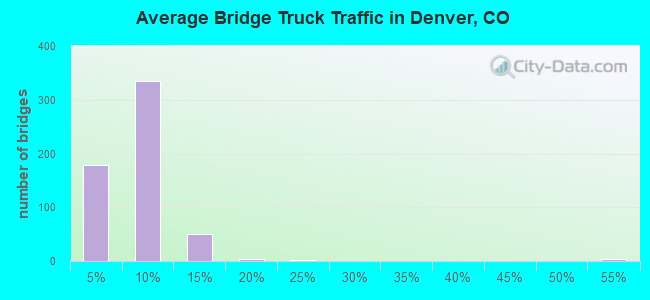
- 1,763,899Total average daily truck traffic
- National Bridge Inventory (NBI) Registered Bridges for Denver
- No street view available for this location
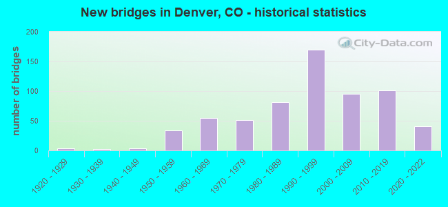
- New bridges - historical statistics
- 11910-1919
- 41920-1929
- 21930-1939
- 31940-1949
- 341950-1959
- 551960-1969
- 511970-1979
- 811980-1989
- 1701990-1999
- 952000-2009
- 1012010-2019
- 412020-2022
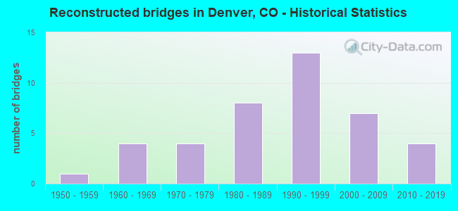
- Reconstructed bridges - Historical Statistics
- 11950-1959
- 41960-1969
- 41970-1979
- 81980-1989
- 131990-1999
- 72000-2009
- 42010-2019
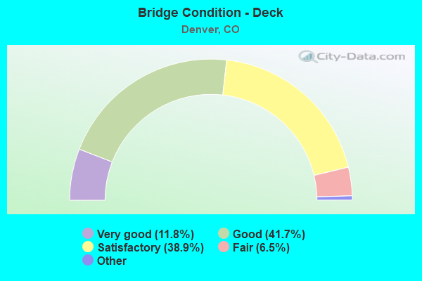
- Bridge Condition - Deck
- 11.8%Very good
- 41.7%Good
- 38.9%Satisfactory
- 6.5%Fair
- 1.0%Poor
- 0.3%Serious
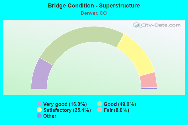
- Bridge Condition - Superstructure
- 16.8%Very good
- 49.0%Good
- 25.4%Satisfactory
- 8.0%Fair
- 0.8%Poor
- 0.3%Serious
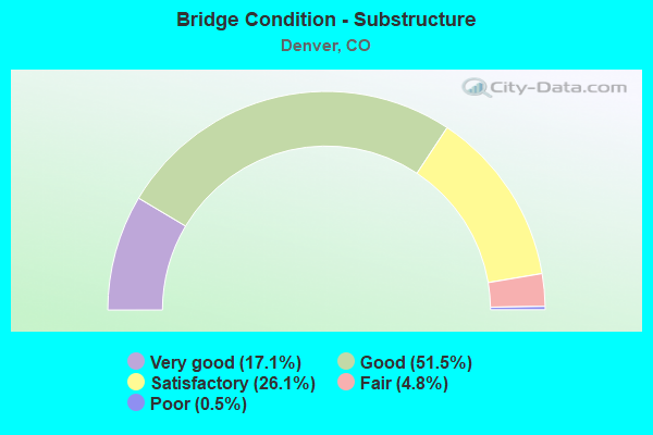
- Bridge Condition - Substructure
- 17.1%Very good
- 51.5%Good
- 26.1%Satisfactory
- 4.8%Fair
- 0.5%Poor
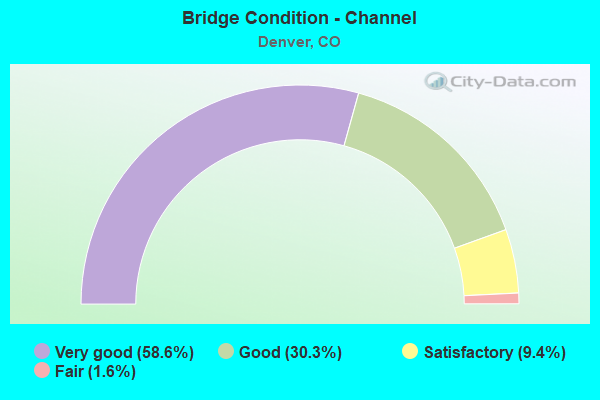
- Bridge Condition - Channel
- 58.6%Very good
- 30.3%Good
- 9.4%Satisfactory
- 1.6%Fair
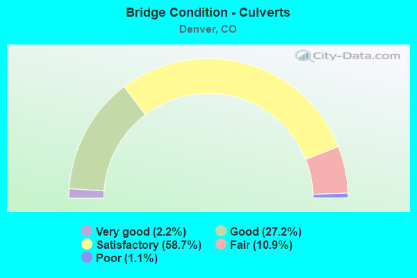
- Bridge Condition - Culverts
- 2.2%Very good
- 27.2%Good
- 58.7%Satisfactory
- 10.9%Fair
- 1.1%Poor
Find on map >> Show street view
Structure Number: D-01-CC-25, Location: CORONA ST AT SPEER BLVD (Lat: 39.718619, Lng: -104.973892), Route carried "on" structure: City street , Year Built: 1957, Status: Open, Structure Length: 3.43m (11.25ft), Average Daily Traffic: 6,594 (year 2021), Truck Traffic: 5%, Average Future Daily Traffic: 7,319 (year 2041), Features Intersected: CHERRY CREEK, Facility Carried by Structure: CORONA ST
Minimum Vertical Clearance: 30+ m (98+ ft), Kilometerpoint: 0.006, Lanes on structure: 3, Owner: City or Municipal Highway Agency, Approaching Roadway Width: 9.1m (29.9ft), Skew: 2 degrees, Material/Design: Concrete continuous, Design/Construction: Tee Beam, Number Of Spans In Main Unit: 2, Length of Maximum Span: 16.2m (53.1ft), Curb or Sidewalk Widths: Left: 1.5m (4.9ft), Right: 0.5m (1.6ft), Curb-To-Curb Width: 12.2m (40.0ft), Out-to-Out Width: 14.9m (48.9ft)
Condition: Deck: Good, Superstructure: Satisfactory, Substructure: Good, Channel: Very good, Operating Rating: 36.3 metric tons, Method Used To Determine Operating Rating: Load Factor (LF), Inventory Rating: 32.7 metric tons, Method Used To Determine Inventory Rating: Load Factor (LF), Structural Evaluation: Equal to present minimum criteria, Deck Geometry: Meets minimum limits, Waterway Adequacy: Equal to present desirable criteria, Approach Roadway Alignment: Equal to present desirable criteria, Designated Inspection Frequency: Every 24 months, Inspection Date: October 2020, Deck Structure Type: Concrete Cast-file-Place, Wearing Surface/Protective System: Wearing Surface: Bituminous
Find on map >> Show street view
Structure Number: D-01-CC-260A, Location: DOWNING ST AT SPEER BLVD (Lat: 39.718472, Lng: -104.973219), Route carried "on" structure: City street , Year Built: 1983, Status: Open, Structure Length: 3.35m (10.99ft), Average Daily Traffic: 9,726 (year 2021), Truck Traffic: 5%, Average Future Daily Traffic: 10,796 (year 2041), Features Intersected: CHERRY CREEK, Facility Carried by Structure: DOWNING ST
Minimum Vertical Clearance: 30+ m (98+ ft), Kilometerpoint: 0.201, Lanes on structure: 4, Owner: City or Municipal Highway Agency, Approaching Roadway Width: 12.2m (40.0ft), Skew: 2 degrees, Material/Design: Prestressed concrete, Design/Construction: Tee Beam, Number Of Spans In Main Unit: 2, Length of Maximum Span: 15.5m (50.9ft), Curb or Sidewalk Widths: Left: 3.4m (11.2ft), Right: 3.0m (9.8ft), Curb-To-Curb Width: 13.8m (45.3ft), Out-to-Out Width: 21.1m (69.2ft)
Condition: Deck: Satisfactory, Superstructure: Satisfactory, Substructure: Very good, Channel: Very good, Operating Rating: 53.3 metric tons, Method Used To Determine Operating Rating: Load Factor (LF), Inventory Rating: 32.0 metric tons, Method Used To Determine Inventory Rating: Load Factor (LF), Structural Evaluation: Equal to present minimum criteria, Deck Geometry: High priority of replacement, Waterway Adequacy: Equal to present desirable criteria, Approach Roadway Alignment: Equal to present desirable criteria, Length Of Structure Improvement: 3.35m (10.99ft), Designated Inspection Frequency: Every 24 months, Inspection Date: October 2020, Bridge Improvement Cost: $708,000, Roadway Improvement Cost: $71,000, Total Project Cost: $779,000 ( Estimate for 2014), Deck Structure Type: Concrete Cast-file-Place, Wearing Surface/Protective System: Wearing Surface: Bituminous, Membrane: Preformed Fabric
Find on map >> Show street view
Structure Number: D-01-CC-27, Location: 1ST AVE AT DOWNING ST (Lat: 39.718186, Lng: -104.972383), Route carried "on" structure: City street , Year Built: 1957, Status: Open, Structure Length: 14.02m (46.00ft), Average Daily Traffic: 26,591 (year 2021), Truck Traffic: 5%, Average Future Daily Traffic: 29,516 (year 2041), Features Intersected: CHERRY CREEK, Facility Carried by Structure: EBnd 1ST AVE
Minimum Vertical Clearance: 30+ m (98+ ft), Kilometerpoint: 0.019, Lanes on structure: 3, Owner: City or Municipal Highway Agency, Approaching Roadway Width: 11.0m (36.1ft), Material/Design: Concrete continuous, Design/Construction: Tee Beam, Number Of Spans In Main Unit: 8, Number Of Approach Spans: 2, Length of Maximum Span: 16.2m (53.1ft), Curb or Sidewalk Widths: Left: 0.0m, Right: 1.5m (4.9ft), Curb-To-Curb Width: 11.4m (37.4ft), Out-to-Out Width: 13.6m (44.6ft)
Condition: Deck: Satisfactory, Superstructure: Fair, Substructure: Satisfactory, Channel: Very good, Operating Rating: 36.3 metric tons, Method Used To Determine Operating Rating: Load Factor (LF), Inventory Rating: 32.7 metric tons, Method Used To Determine Inventory Rating: Load Factor (LF), Structural Evaluation: Somewhat better than minimum adequacy, Deck Geometry: High priority of replacement, Waterway Adequacy: Equal to present desirable criteria, Approach Roadway Alignment: Equal to present desirable criteria, Length Of Structure Improvement: 14.94m (49.02ft), Designated Inspection Frequency: Every 24 months, Inspection Date: October 2020, Bridge Improvement Cost: $2,350,000, Roadway Improvement Cost: $235,000, Total Project Cost: $2,585,000 ( Estimate for 2014), Deck Structure Type: Concrete Cast-file-Place, Wearing Surface/Protective System: Wearing Surface: Bituminous
Find on map >> Show street view
Structure Number: D-01-CC-281, Location: JUST S OF CHERRY CREEK N (Lat: 39.715569, Lng: -104.958997), Route carried "on" structure: City street , Year Built: 1965, Status: Open, Structure Length: 2.56m (8.40ft), Average Daily Traffic: 22,904 (year 2021), Truck Traffic: 5%, Average Future Daily Traffic: 25,423 (year 2041), Features Intersected: CHERRY CREEK, Facility Carried by Structure: NB UNIVERSITY BLVD
Minimum Vertical Clearance: 30+ m (98+ ft), Kilometerpoint: 0.029, Lanes on structure: 4, Base Highway Network: Yes, Owner: City or Municipal Highway Agency, Approaching Roadway Width: 15.2m (49.9ft), Skew: 20 degrees, Material/Design: Steel, Design/Construction: Stringer/Multi-beam, Number Of Spans In Main Unit: 1, Length of Maximum Span: 24.7m (81.0ft), Curb or Sidewalk Widths: Left: 0.0m, Right: 1.5m (4.9ft), Curb-To-Curb Width: 15.2m (49.9ft), Out-to-Out Width: 21.3m (69.9ft)
Condition: Deck: Good, Superstructure: Satisfactory, Substructure: Satisfactory, Channel: Very good, Operating Rating: 58.8 metric tons, Method Used To Determine Operating Rating: Load Factor (LF), Inventory Rating: 35.2 metric tons, Method Used To Determine Inventory Rating: Load Factor (LF), Structural Evaluation: Equal to present minimum criteria, Deck Geometry: High priority of corrective action, Waterway Adequacy: Equal to present desirable criteria, Approach Roadway Alignment: Equal to present desirable criteria, Designated Inspection Frequency: Every 24 months, Inspection Date: October 2020, Deck Structure Type: Concrete Cast-file-Place, Wearing Surface/Protective System: Wearing Surface: Other
Find on map >> Show street view
Structure Number: D-01-CC-282A, Location: S OF CHERRY CREEK DR (Lat: 39.715572, Lng: -104.958997), Route carried "on" structure: City street , Year Built: 1989, Status: Open, Structure Length: 3.22m (10.56ft), Average Daily Traffic: 22,904 (year 2021), Truck Traffic: 5%, Average Future Daily Traffic: 25,423 (year 2041), Features Intersected: CHERRY CREEK, Facility Carried by Structure: SB UNIVERSITY BLVD
Minimum Vertical Clearance: 30+ m (98+ ft), Kilometerpoint: 0.031, Lanes on structure: 4, Base Highway Network: Yes, Owner: City or Municipal Highway Agency, Approaching Roadway Width: 15.2m (49.9ft), Skew: 21 degrees, Material/Design: Steel, Design/Construction: Stringer/Multi-beam, Number Of Spans In Main Unit: 1, Length of Maximum Span: 31.5m (103.3ft), Curb or Sidewalk Widths: Left: 2.1m (6.9ft), Right: 0.0m, Curb-To-Curb Width: 13.8m (45.3ft), Out-to-Out Width: 15.1m (49.5ft)
Condition: Deck: Good, Superstructure: Good, Substructure: Good, Channel: Very good, Operating Rating: 60.9 metric tons, Method Used To Determine Operating Rating: Load Factor (LF), Inventory Rating: 36.5 metric tons, Method Used To Determine Inventory Rating: Load Factor (LF), Structural Evaluation: Better than present minimum criteria, Deck Geometry: High priority of replacement, Waterway Adequacy: Equal to present desirable criteria, Approach Roadway Alignment: Equal to present desirable criteria, Designated Inspection Frequency: Every 24 months, Inspection Date: October 2020, Deck Structure Type: Concrete Cast-file-Place, Wearing Surface/Protective System: Wearing Surface: Bituminous, Membrane: Built-up
Find on map >> Show street view
Structure Number: D-01-CC-310A, Location: S HOLLY AT CHERRY CK DR (Lat: 39.696294, Lng: -104.922047), Route carried "on" structure: City street , Year Built: 2007, Status: Open, Structure Length: 5.33m (17.49ft), Average Daily Traffic: 19,122 (year 2021), Truck Traffic: 6%, Average Future Daily Traffic: 21,226 (year 2041), Design Load: HS 25 or greater, Features Intersected: CHERRY CREEK, Facility Carried by Structure: HOLLY ST
Minimum Vertical Clearance: 30+ m (98+ ft), Kilometerpoint: 2.241, Lanes on structure: 4, Owner: City or Municipal Highway Agency, Approaching Roadway Width: 15.2m (49.9ft), Skew: 1 degrees, Material/Design: Prestressed concrete continuous, Design/Construction: Box Beam or Girders - Multiple, Number Of Spans In Main Unit: 2, Length of Maximum Span: 25.9m (85.0ft), Curb or Sidewalk Widths: Left: 2.4m (7.9ft), Right: 6.1m (20.0ft), Curb-To-Curb Width: 19.8m (65.0ft), Out-to-Out Width: 29.3m (96.1ft)
Condition: Deck: Very good, Superstructure: Very good, Substructure: Very good, Channel: Very good, Operating Rating: 84.2 metric tons, Method Used To Determine Operating Rating: Load Factor (LF), Inventory Rating: 50.4 metric tons, Method Used To Determine Inventory Rating: Load Factor (LF), Structural Evaluation: Equal to present desirable criteria, Deck Geometry: Better than present minimum criteria, Waterway Adequacy: Equal to present desirable criteria, Approach Roadway Alignment: Equal to present desirable criteria, Length Of Structure Improvement: 5.33m (17.49ft), Designated Inspection Frequency: Every 24 months, Inspection Date: October 2020, Deck Structure Type: Concrete Cast-file-Place, Wearing Surface/Protective System: Wearing Surface: Bituminous, Membrane: Built-up, Deck Protection: Epoxy Coated Reinforcing
Find on map >> Show street view
Structure Number: D-01-CC-32, Location: MONACO AT CHERRY CREEK DR (Lat: 39.690933, Lng: -104.912906), Route carried "on" structure: City street , Year Built: 1964, Status: Open, Structure Length: 5.55m (18.21ft), Average Daily Traffic: 25,282 (year 2021), Truck Traffic: 5%, Average Future Daily Traffic: 28,063 (year 2041), Design Load: HS 20, Features Intersected: CHERRY CREEK, Facility Carried by Structure: MONACO PRKWY
Minimum Vertical Clearance: 30+ m (98+ ft), Kilometerpoint: 0.641, Lanes on structure: 7, Base Highway Network: Yes, Owner: City or Municipal Highway Agency, Approaching Roadway Width: 23.8m (78.1ft), Skew: 3 degrees, Material/Design: Steel continuous, Design/Construction: Stringer/Multi-beam, Number Of Spans In Main Unit: 3, Length of Maximum Span: 20.7m (67.9ft), Curb or Sidewalk Widths: Left: 1.5m (4.9ft), Right: 1.5m (4.9ft), Curb-To-Curb Width: 23.8m (78.1ft), Out-to-Out Width: 27.4m (89.9ft)
Condition: Deck: Fair, Superstructure: Satisfactory, Substructure: Satisfactory, Channel: Satisfactory, Operating Rating: 34.4 metric tons, Method Used To Determine Operating Rating: Load Factor (LF), Inventory Rating: 20.6 metric tons, Method Used To Determine Inventory Rating: Load Factor (LF), Structural Evaluation: Somewhat better than minimum adequacy, Deck Geometry: High priority of replacement, Waterway Adequacy: Equal to present desirable criteria, Approach Roadway Alignment: Equal to present desirable criteria, Length Of Structure Improvement: 5.55m (18.21ft), Designated Inspection Frequency: Every 24 months, Inspection Date: October 2020, Deck Structure Type: Concrete Cast-file-Place, Wearing Surface/Protective System: Wearing Surface: Bituminous
Find on map >> Show street view
Structure Number: D-01-CC-332, Location: QUEBEC AT CHERRY CREEK DR (Lat: 39.685611, Lng: -104.903631), Route carried "on" structure: City street , Year Built: 2007, Status: Open, Structure Length: 7.62m (25.00ft), Average Daily Traffic: 15,084 (year 2021), Average Future Daily Traffic: 16,744 (year 2041), Design Load: HS 25 or greater, Features Intersected: CHERRY CREEK, Facility Carried by Structure: SB QUEBEC ST
Minimum Vertical Clearance: 30+ m (98+ ft), Kilometerpoint: 0.407, Lanes on structure: 3, Owner: City or Municipal Highway Agency, Approaching Roadway Width: 11.6m (38.1ft), Skew: 23 degrees, Material/Design: Prestressed concrete continuous, Design/Construction: Box Beam or Girders - Multiple, Number Of Spans In Main Unit: 1, Number Of Approach Spans: 2, Length of Maximum Span: 29.9m (98.1ft), Curb or Sidewalk Widths: Left: 2.6m (8.5ft), Right: 0.5m (1.6ft), Curb-To-Curb Width: 11.6m (38.1ft), Out-to-Out Width: 15.1m (49.5ft)
Condition: Deck: Good, Superstructure: Very good, Substructure: Good, Channel: Good, Operating Rating: 62.0 metric tons, Method Used To Determine Operating Rating: Load Factor (LF), Inventory Rating: 34.2 metric tons, Method Used To Determine Inventory Rating: Load Factor (LF), Structural Evaluation: Better than present minimum criteria, Deck Geometry: High priority of replacement, Waterway Adequacy: Equal to present desirable criteria, Approach Roadway Alignment: Equal to present desirable criteria, Designated Inspection Frequency: Every 24 months, Inspection Date: October 2020, Deck Structure Type: Concrete Cast-file-Place, Wearing Surface/Protective System: Wearing Surface: Bituminous, Membrane: Built-up, Deck Protection: Epoxy Coated Reinforcing
Find on map >> Show street view
Structure Number: D-01-CC-333, Location: QUEBEC AT CHERRY CREEK DR (Lat: 39.685428, Lng: -104.903453), Route carried "on" structure: City street , Year Built: 1983, Status: Open, Structure Length: 7.53m (24.70ft), Average Daily Traffic: 21,471 (year 2021), Truck Traffic: 6%, Average Future Daily Traffic: 23,833 (year 2041), Design Load: HS 20, Features Intersected: CHERRY CREEK, Facility Carried by Structure: NB QUEBEC ST
Minimum Vertical Clearance: 30+ m (98+ ft), Kilometerpoint: 0.430, Lanes on structure: 2, Owner: City or Municipal Highway Agency, Approaching Roadway Width: 8.2m (26.9ft), Skew: 23 degrees, Material/Design: Steel continuous, Design/Construction: Stringer/Multi-beam, Number Of Spans In Main Unit: 3, Length of Maximum Span: 29.9m (98.1ft), Curb or Sidewalk Widths: Left: 1.6m (5.2ft), Right: 2.4m (7.9ft), Curb-To-Curb Width: 8.3m (27.2ft), Out-to-Out Width: 12.7m (41.7ft)
Condition: Deck: Satisfactory, Superstructure: Good, Substructure: Good, Channel: Good, Operating Rating: 48.8 metric tons, Method Used To Determine Operating Rating: Load Factor (LF), Inventory Rating: 29.3 metric tons, Method Used To Determine Inventory Rating: Load Factor (LF), Structural Evaluation: Better than present minimum criteria, Deck Geometry: High priority of corrective action, Waterway Adequacy: Equal to present desirable criteria, Approach Roadway Alignment: Equal to present desirable criteria, Length Of Structure Improvement: 7.53m (24.70ft), Designated Inspection Frequency: Every 24 months, Inspection Date: October 2020, Deck Structure Type: Concrete Cast-file-Place, Wearing Surface/Protective System: Wearing Surface: Bituminous, Membrane: Preformed Fabric
Find on map >> Show street view
Structure Number: D-02-PR-01, Location: FRANKLIN AT RACE CT (Lat: 39.790894, Lng: -104.968817), Route carried "on" structure: City street , Year Built: 1965, Status: Open, Structure Length: 9.46m (31.04ft), Average Daily Traffic: 2,765 (year 2021), Truck Traffic: 9%, Average Future Daily Traffic: 3,069 (year 2041), Features Intersected: SOUTH PLATTE RIVER, Facility Carried by Structure: FRANKLIN ST
Minimum Vertical Clearance: 30+ m (98+ ft), Kilometerpoint: 0.309, Lanes on structure: 2, Owner: City or Municipal Highway Agency, Approaching Roadway Width: 13.4m (44.0ft), Skew: 4 degrees, Material/Design: Prestressed concrete, Design/Construction: Stringer/Multi-beam, Number Of Spans In Main Unit: 4, Length of Maximum Span: 23.3m (76.4ft), Curb or Sidewalk Widths: Left: 1.5m (4.9ft), Right: 0.2m (0.7ft), Curb-To-Curb Width: 13.4m (44.0ft), Out-to-Out Width: 15.8m (51.8ft)
Condition: Deck: Satisfactory, Superstructure: Good, Substructure: Satisfactory, Channel: Satisfactory, Operating Rating: 52.9 metric tons, Method Used To Determine Operating Rating: Load Factor (LF), Inventory Rating: 31.8 metric tons, Method Used To Determine Inventory Rating: Load Factor (LF), Structural Evaluation: Equal to present minimum criteria, Deck Geometry: Better than present minimum criteria, Waterway Adequacy: Equal to present minimum criteria, Approach Roadway Alignment: Equal to present desirable criteria, Designated Inspection Frequency: Every 24 months, Inspection Date: October 2020, Deck Structure Type: Concrete Cast-file-Place, Wearing Surface/Protective System: Wearing Surface: Bituminous, Membrane: Built-up
Find on map >> Show street view
Structure Number: D-02-PR-035, Location: ARKINS CT N OF 38TH ST (Lat: 39.776261, Lng: -104.976836), Route carried "on" structure: City street , Year Built: 1962, Year Reconstructed: 2018, Status: Open, Structure Length: 1.12m (3.67ft), Average Daily Traffic: 1,724 (year 2021), Truck Traffic: 14%, Average Future Daily Traffic: 1,913 (year 2041), Features Intersected: LOCAL DRAINAGE, Facility Carried by Structure: ARKINS CT
Minimum Vertical Clearance: 30.45m (99.90ft), Kilometerpoint: 1.803, Lanes on structure: 3, Owner: City or Municipal Highway Agency, Approaching Roadway Width: 12.5m (41.0ft), Skew: 3 degrees, Material/Design: Concrete, Design/Construction: Culvert, Number Of Spans In Main Unit: 3, Length of Maximum Span: 4.2m (13.8ft), Curb or Sidewalk Widths: Left: 3.7m (12.1ft), Right: 0.0m, Out-to-Out Width: 30.4m (99.7ft)
Condition: Channel: Good, Culverts: Good, Operating Rating: 36.3 metric tons, Method Used To Determine Operating Rating: Field evaluation and documented engineering judgment, Inventory Rating: 32.7 metric tons, Method Used To Determine Inventory Rating: Field evaluation and documented engineering judgment, Structural Evaluation: Better than present minimum criteria, Waterway Adequacy: Equal to present desirable criteria, Approach Roadway Alignment: Equal to present desirable criteria, Designated Inspection Frequency: Every 24 months, Inspection Date: October 2020
Find on map >> Show street view
Structure Number: D-02-PR-040A, Location: JUST NORTH OF ARKINS CT (Lat: 39.775117, Lng: -104.978083), Route carried "on" structure: City street , Year Built: 1976, Status: Open, Structure Length: 8.11m (26.61ft), Average Daily Traffic: 15,173 (year 2021), Truck Traffic: 10%, Average Future Daily Traffic: 16,842 (year 2041), Design Load: HS 20, Features Intersected: SOUTH PLATTE RIVER, Facility Carried by Structure: 38TH ST
Minimum Vertical Clearance: 30.45m (99.90ft), Kilometerpoint: 0.743, Lanes on structure: 4, Owner: City or Municipal Highway Agency, Approaching Roadway Width: 14.6m (47.9ft), Skew: 3 degrees, Material/Design: Steel continuous, Design/Construction: Stringer/Multi-beam, Number Of Spans In Main Unit: 2, Length of Maximum Span: 39.0m (128.0ft), Curb or Sidewalk Widths: Left: 1.5m (4.9ft), Right: 1.5m (4.9ft), Curb-To-Curb Width: 18.3m (60.0ft), Out-to-Out Width: 21.9m (71.9ft)
Condition: Deck: Good, Superstructure: Satisfactory, Substructure: Good, Channel: Very good, Operating Rating: 57.6 metric tons, Method Used To Determine Operating Rating: Load Factor (LF), Inventory Rating: 34.6 metric tons, Method Used To Determine Inventory Rating: Load Factor (LF), Structural Evaluation: Equal to present minimum criteria, Deck Geometry: Somewhat better than minimum adequacy, Waterway Adequacy: Equal to present desirable criteria, Approach Roadway Alignment: Better than present minimum criteria, Designated Inspection Frequency: Every 24 months, Inspection Date: October 2020, Deck Structure Type: Concrete Cast-file-Place, Wearing Surface/Protective System: Wearing Surface: Bituminous, Membrane: Built-up
Find on map >> Show street view
Structure Number: D-02-PR-05, Location: 31ST ST AT ARKINS CT (Lat: 39.767406, Lng: -104.984728), Route carried "on" structure: City street , Year Built: 1974, Status: Open, Structure Length: 6.22m (20.41ft), Average Daily Traffic: 4,395 (year 2021), Truck Traffic: 14%, Average Future Daily Traffic: 4,878 (year 2041), Features Intersected: SOUTH PLATTE RIVER, Facility Carried by Structure: 31ST ST
Minimum Vertical Clearance: 30.45m (99.90ft), Kilometerpoint: 0.228, Lanes on structure: 2, Owner: City or Municipal Highway Agency, Approaching Roadway Width: 11.0m (36.1ft), Material/Design: Prestressed concrete, Design/Construction: Stringer/Multi-beam, Number Of Spans In Main Unit: 2, Length of Maximum Span: 29.9m (98.1ft), Curb or Sidewalk Widths: Left: 0.5m (1.6ft), Right: 1.2m (3.9ft), Curb-To-Curb Width: 9.4m (30.8ft), Out-to-Out Width: 11.6m (38.1ft)
Condition: Deck: Satisfactory, Superstructure: Good, Substructure: Satisfactory, Channel: Good, Operating Rating: 75.7 metric tons, Method Used To Determine Operating Rating: Load Factor (LF), Inventory Rating: 47.1 metric tons, Method Used To Determine Inventory Rating: Load Factor (LF), Structural Evaluation: Equal to present minimum criteria, Deck Geometry: Meets minimum limits, Waterway Adequacy: Equal to present desirable criteria, Approach Roadway Alignment: Equal to present desirable criteria, Designated Inspection Frequency: Every 24 months, Inspection Date: October 2020, Deck Structure Type: Concrete Cast-file-Place, Wearing Surface/Protective System: Wearing Surface: Bituminous, Membrane: Built-up
Find on map >> Show street view
Structure Number: D-02-PR-062, Location: 19TH ST AT PLATTE RIVER (Lat: 39.760206, Lng: -105.003858), Route carried "on" structure: City street , Year Built: 1992, Status: Open, Structure Length: 6.27m (20.57ft), Average Daily Traffic: 4,342 (year 2021), Truck Traffic: 6%, Average Future Daily Traffic: 4,819 (year 2041), Design Load: HS 20, Features Intersected: SOUTH PLATTE RIVER, Facility Carried by Structure: 19TH ST
Minimum Vertical Clearance: 30.45m (99.90ft), Kilometerpoint: 0.346, Lanes on structure: 2, Owner: City or Municipal Highway Agency, Approaching Roadway Width: 13.4m (44.0ft), Skew: 1 degrees, Material/Design: Prestressed concrete continuous, Design/Construction: Stringer/Multi-beam, Number Of Spans In Main Unit: 2, Length of Maximum Span: 31.4m (103.0ft), Curb or Sidewalk Widths: Left: 1.5m (4.9ft), Right: 0.2m (0.7ft), Curb-To-Curb Width: 13.4m (44.0ft), Out-to-Out Width: 15.8m (51.8ft)
Condition: Deck: Good, Superstructure: Very good, Substructure: Very good, Channel: Very good, Operating Rating: 66.6 metric tons, Method Used To Determine Operating Rating: Load Factor (LF), Inventory Rating: 39.9 metric tons, Method Used To Determine Inventory Rating: Load Factor (LF), Structural Evaluation: Equal to present desirable criteria, Deck Geometry: Better than present minimum criteria, Waterway Adequacy: Equal to present desirable criteria, Approach Roadway Alignment: Equal to present desirable criteria, Designated Inspection Frequency: Every 24 months, Inspection Date: October 2020, Deck Structure Type: Concrete Cast-file-Place, Wearing Surface/Protective System: Wearing Surface: Bituminous, Membrane: Preformed Fabric, Deck Protection: Epoxy Coated Reinforcing
Find on map >> Show street view
Structure Number: D-02-PR-070A, Location: E OF PLATTE DRIVE (Lat: 39.755292, Lng: -105.007778), Route carried "on" structure: City street , Year Built: 1975, Status: Open, Structure Length: 6.16m (20.21ft), Average Daily Traffic: 11,374 (year 2021), Truck Traffic: 6%, Average Future Daily Traffic: 12,625 (year 2041), Features Intersected: SOUTH PLATTE RIVER, Facility Carried by Structure: 15TH ST
Minimum Vertical Clearance: 30.45m (99.90ft), Kilometerpoint: 2.354, Lanes on structure: 4, Owner: City or Municipal Highway Agency, Approaching Roadway Width: 15.2m (49.9ft), Material/Design: Prestressed concrete continuous, Design/Construction: Stringer/Multi-beam, Number Of Spans In Main Unit: 2, Length of Maximum Span: 30.2m (99.1ft), Curb or Sidewalk Widths: Left: 1.5m (4.9ft), Right: 1.8m (5.9ft), Curb-To-Curb Width: 14.6m (47.9ft), Out-to-Out Width: 18.5m (60.7ft)
Condition: Deck: Satisfactory, Superstructure: Good, Substructure: Satisfactory, Channel: Very good, Operating Rating: 55.8 metric tons, Method Used To Determine Operating Rating: Load Factor (LF), Inventory Rating: 33.5 metric tons, Method Used To Determine Inventory Rating: Load Factor (LF), Structural Evaluation: Equal to present minimum criteria, Deck Geometry: High priority of replacement, Waterway Adequacy: Equal to present desirable criteria, Approach Roadway Alignment: Equal to present desirable criteria, Length Of Structure Improvement: 6.16m (20.21ft), Designated Inspection Frequency: Every 24 months, Inspection Date: October 2020, Bridge Improvement Cost: $790,000, Roadway Improvement Cost: $79,000, Total Project Cost: $869,000 ( Estimate for 2014), Deck Structure Type: Concrete Cast-file-Place, Wearing Surface/Protective System: Wearing Surface: Bituminous, Membrane: Built-up
Find on map >> Show street view
Structure Number: D-02-PR-090A, Location: WB SPEER NEAR I-25 EXIT (Lat: 39.753989, Lng: -105.009628), Route carried "on" structure: City street , Year Built: 1999, Status: Open, Structure Length: 12.63m (41.44ft), Average Daily Traffic: 20,687 (year 2021), Truck Traffic: 5%, Average Future Daily Traffic: 22,962 (year 2041), Design Load: HS 25 or greater, Features Intersected: S PLATTE RVR/RR/WATER ST, Facility Carried by Structure: WB SPEER BLVD
Minimum Vertical Clearance: 5.61m (18.41ft), Kilometerpoint: 3.625, Lanes on structure: 4, Lanes under structure: 2, Base Highway Network: Yes, Owner: City or Municipal Highway Agency, Approaching Roadway Width: 14.7m (48.2ft), Skew: 11 degrees, Material/Design: Steel, Design/Construction: Arch - Thru, Number Of Spans In Main Unit: 1, Number Of Approach Spans: 2, Length of Maximum Span: 76.8m (252.0ft), Curb or Sidewalk Widths: Left: 2.2m (7.2ft), Right: 0.0m, Curb-To-Curb Width: 15.5m (50.9ft), Out-to-Out Width: 19.1m (62.7ft)
Condition: Deck: Satisfactory, Superstructure: Satisfactory, Substructure: Satisfactory, Channel: Very good, Operating Rating: 72.0 metric tons, Method Used To Determine Operating Rating: Load Factor (LF), Inventory Rating: 43.2 metric tons, Method Used To Determine Inventory Rating: Load Factor (LF), Structural Evaluation: Equal to present minimum criteria, Deck Geometry: Meets minimum limits, Underclear: Somewhat better than minimum adequacy, Waterway Adequacy: Superior to present desirable criteria, Approach Roadway Alignment: Equal to present desirable criteria, Designated Inspection Frequency: Every 24 months, Critical Feature Inspection Frequency: Every 24 months, Inspection Date: October 2020, Critical Feature Inspection Date: October 2020, Deck Structure Type: Concrete Cast-file-Place, Wearing Surface/Protective System: Wearing Surface: Bituminous, Membrane: Built-up, Deck Protection: Epoxy Coated Reinforcing
Find on map >> Show street view
Structure Number: D-02-PR-100A, Location: EB SPEER NEAR I-25 EXIT (Lat: 39.753836, Lng: -105.009875), Route carried "on" structure: City street , Year Built: 2000, Status: Open, Structure Length: 12.02m (39.44ft), Average Daily Traffic: 20,504 (year 2021), Truck Traffic: 5%, Average Future Daily Traffic: 22,759 (year 2041), Design Load: HS 25 or greater, Features Intersected: S PLATTE RVR/RR/WATER ST, Facility Carried by Structure: EB SPEER BLVD
Minimum Vertical Clearance: 5.69m (18.67ft), Kilometerpoint: 0.576, Lanes on structure: 4, Lanes under structure: 2, Base Highway Network: Yes, Owner: City or Municipal Highway Agency, Approaching Roadway Width: 11.6m (38.1ft), Skew: 11 degrees, Material/Design: Steel, Design/Construction: Arch - Thru, Number Of Spans In Main Unit: 1, Number Of Approach Spans: 2, Length of Maximum Span: 76.7m (251.6ft), Curb or Sidewalk Widths: Left: 0.0m, Right: 2.1m (6.9ft), Curb-To-Curb Width: 15.4m (50.5ft), Out-to-Out Width: 19.0m (62.3ft)
Condition: Deck: Satisfactory, Superstructure: Good, Substructure: Satisfactory, Channel: Very good, Operating Rating: 72.0 metric tons, Method Used To Determine Operating Rating: Load Factor (LF), Inventory Rating: 43.2 metric tons, Method Used To Determine Inventory Rating: Load Factor (LF), Structural Evaluation: Equal to present minimum criteria, Deck Geometry: Meets minimum limits, Underclear: Somewhat better than minimum adequacy, Waterway Adequacy: Superior to present desirable criteria, Approach Roadway Alignment: Equal to present desirable criteria, Designated Inspection Frequency: Every 24 months, Critical Feature Inspection Frequency: Every 24 months, Inspection Date: October 2020, Critical Feature Inspection Date: October 2020, Deck Structure Type: Concrete Cast-file-Place, Wearing Surface/Protective System: Wearing Surface: Bituminous, Membrane: Built-up, Deck Protection: Epoxy Coated Reinforcing
Find on map >> Show street view
Structure Number: D-02-PR-120A, Location: JUST WEST OF ZUNI STREET (Lat: 39.739819, Lng: -105.017631), Route carried "on" structure: City street , Year Built: 2002, Status: Open, Structure Length: 4.86m (15.94ft), Average Daily Traffic: 2,828 (year 2021), Truck Traffic: 4%, Average Future Daily Traffic: 3,139 (year 2041), Design Load: HS 25 or greater, Features Intersected: SOUTH PLATTE RIVER, Facility Carried by Structure: LOWER COLFAX AVE
Minimum Vertical Clearance: 30+ m (98+ ft), Kilometerpoint: 0.108, Lanes on structure: 4, Owner: City or Municipal Highway Agency, Approaching Roadway Width: 14.6m (47.9ft), Material/Design: Prestressed concrete continuous, Design/Construction: Box Beam or Girders - Single/Spread, Number Of Spans In Main Unit: 3, Length of Maximum Span: 17.4m (57.1ft), Curb or Sidewalk Widths: Left: 3.0m (9.8ft), Right: 3.0m (9.8ft), Curb-To-Curb Width: 15.8m (51.8ft), Out-to-Out Width: 22.9m (75.1ft)
Condition: Deck: Satisfactory, Superstructure: Good, Substructure: Good, Channel: Very good, Operating Rating: 72.8 metric tons, Method Used To Determine Operating Rating: Load Factor (LF), Inventory Rating: 40.5 metric tons, Method Used To Determine Inventory Rating: Load Factor (LF), Structural Evaluation: Better than present minimum criteria, Deck Geometry: Meets minimum limits, Waterway Adequacy: Equal to present desirable criteria, Approach Roadway Alignment: Equal to present desirable criteria, Designated Inspection Frequency: Every 24 months, Inspection Date: October 2020, Deck Structure Type: Concrete Cast-file-Place, Wearing Surface/Protective System: Wearing Surface: Bituminous, Membrane: Built-up, Deck Protection: Epoxy Coated Reinforcing
Find on map >> Show street view
Structure Number: D-02-PR-130A, Location: JUST WEST OF ZUNI STREET (Lat: 39.736819, Lng: -105.017628), Route carried "on" structure: City street , Year Built: 1988, Status: Open, Structure Length: 4.79m (15.72ft), Average Daily Traffic: 5,825 (year 2021), Truck Traffic: 4%, Average Future Daily Traffic: 6,466 (year 2041), Features Intersected: SOUTH PLATTE RIVER, Facility Carried by Structure: 13TH AVE
Minimum Vertical Clearance: 30.45m (99.90ft), Kilometerpoint: 2.619, Lanes on structure: 2, Owner: City or Municipal Highway Agency, Approaching Roadway Width: 9.1m (29.9ft), Material/Design: Prestressed concrete continuous, Design/Construction: Slab, Number Of Spans In Main Unit: 3, Length of Maximum Span: 15.5m (50.9ft), Curb or Sidewalk Widths: Left: 2.4m (7.9ft), Right: 2.4m (7.9ft), Curb-To-Curb Width: 9.1m (29.9ft), Out-to-Out Width: 14.6m (47.9ft)
Condition: Deck: Satisfactory, Superstructure: Satisfactory, Substructure: Good, Channel: Good, Inventory Rating: 47.4 metric tons, Method Used To Determine Inventory Rating: Load Factor (LF), Structural Evaluation: Equal to present minimum criteria, Deck Geometry: High priority of corrective action, Waterway Adequacy: Equal to present desirable criteria, Approach Roadway Alignment: Better than present minimum criteria, Designated Inspection Frequency: Every 24 months, Inspection Date: January 2021, Deck Structure Type: Concrete Cast-file-Place, Wearing Surface/Protective System: Wearing Surface: Bituminous, Membrane: Built-up
Find on map >> Show street view
Structure Number: D-02-PR-15, Location: JUST WEST OF ZUNI STREET (Lat: 39.729328, Lng: -105.016803), Route carried "on" structure: City street , Year Built: 1929, Status: Open, Structure Length: 5.23m (17.16ft), Average Daily Traffic: 22,500 (year 2021), Truck Traffic: 6%, Average Future Daily Traffic: 24,975 (year 2041), Features Intersected: SOUTH PLATTE RIVER, Facility Carried by Structure: 8TH AVE
Minimum Vertical Clearance: 30+ m (98+ ft), Kilometerpoint: 6.542, Lanes on structure: 4, Owner: City or Municipal Highway Agency, Approaching Roadway Width: 12.2m (40.0ft), Skew: 1 degrees, Material/Design: Steel, Design/Construction: Girder and Floorbeam System, Number Of Spans In Main Unit: 3, Length of Maximum Span: 16.5m (54.1ft), Curb or Sidewalk Widths: Left: 0.9m (3.0ft), Right: 0.3m (1.0ft), Curb-To-Curb Width: 12.2m (40.0ft), Out-to-Out Width: 14.0m (45.9ft)
Condition: Deck: Fair, Superstructure: Satisfactory, Substructure: Fair, Channel: Satisfactory, Operating Rating: 31.5 metric tons, Method Used To Determine Operating Rating: Load Factor (LF), Inventory Rating: 18.9 metric tons, Method Used To Determine Inventory Rating: Load Factor (LF), Structural Evaluation: Meets minimum limits, Deck Geometry: High priority of replacement, Waterway Adequacy: Better than present minimum criteria, Approach Roadway Alignment: Equal to present desirable criteria, Length Of Structure Improvement: 5.23m (17.16ft), Designated Inspection Frequency: Every 24 months, Critical Feature Inspection Frequency: Every 24 months, Underwater Inspection Frequency: Every 60 months, Inspection Date: October 2020, Critical Feature Inspection Date: October 2020, Underwater Inspection Date: October 2020, Deck Structure Type: Concrete Cast-file-Place, Wearing Surface/Protective System: Wearing Surface: Bituminous
Find on map >> Show street view
Structure Number: D-02-PR-22, Location: MISSISSIPPI AT SANTA FE (Lat: 39.696678, Lng: -104.992489), Route carried "on" structure: City street , Year Built: 1953, Year Reconstructed: 1992, Status: Open, Structure Length: 6.16m (20.21ft), Average Daily Traffic: 17,385 (year 2021), Truck Traffic: 6%, Average Future Daily Traffic: 19,297 (year 2041), Features Intersected: SOUTH PLATTE RIVER, Facility Carried by Structure: MISSISSIPPI AVE
Minimum Vertical Clearance: 30+ m (98+ ft), Kilometerpoint: 0.440, Lanes on structure: 7, Owner: City or Municipal Highway Agency, Approaching Roadway Width: 22.8m (74.8ft), Skew: 1 degrees, Material/Design: Prestressed concrete, Design/Construction: Box Beam or Girders - Single/Spread, Number Of Spans In Main Unit: 4, Length of Maximum Span: 14.9m (48.9ft), Curb or Sidewalk Widths: Left: 1.5m (4.9ft), Right: 2.6m (8.5ft), Curb-To-Curb Width: 26.2m (86.0ft), Out-to-Out Width: 31.3m (102.7ft)
Condition: Deck: Satisfactory, Superstructure: Satisfactory, Substructure: Fair, Channel: Very good, Operating Rating: 40.6 metric tons, Method Used To Determine Operating Rating: Load Factor (LF), Inventory Rating: 18.1 metric tons, Method Used To Determine Inventory Rating: Load Factor (LF), Structural Evaluation: Meets minimum limits, Deck Geometry: Meets minimum limits, Waterway Adequacy: Equal to present desirable criteria, Approach Roadway Alignment: Equal to present desirable criteria, Length Of Structure Improvement: 6.16m (20.21ft), Designated Inspection Frequency: Every 24 months, Inspection Date: October 2020, Bridge Improvement Cost: $1,699,000, Roadway Improvement Cost: $170,000, Total Project Cost: $1,869,000 ( Estimate for 2014), Deck Structure Type: Concrete Cast-file-Place, Wearing Surface/Protective System: Wearing Surface: Bituminous, Membrane: Built-up
Find on map >> Show street view
Structure Number: D-02-PR-25, Location: JUST E OF S PLATTE RIV DR (Lat: 39.689122, Lng: -104.999819), Route carried "on" structure: City street , Year Built: 1956, Status: Open, Structure Length: 4.97m (16.31ft), Average Daily Traffic: 8,951 (year 2021), Truck Traffic: 6%, Average Future Daily Traffic: 9,935 (year 2041), Features Intersected: SOUTH PLATTE RIVER, Facility Carried by Structure: FLORIDA AVE
Minimum Vertical Clearance: 30+ m (98+ ft), Kilometerpoint: 0.833, Lanes on structure: 3, Owner: City or Municipal Highway Agency, Approaching Roadway Width: 14.6m (47.9ft), Material/Design: Prestressed concrete, Design/Construction: Stringer/Multi-beam, Number Of Spans In Main Unit: 2, Length of Maximum Span: 23.8m (78.1ft), Curb or Sidewalk Widths: Left: 1.5m (4.9ft), Right: 1.5m (4.9ft), Curb-To-Curb Width: 14.6m (47.9ft), Out-to-Out Width: 18.3m (60.0ft)
Condition: Deck: Satisfactory, Superstructure: Satisfactory, Substructure: Satisfactory, Channel: Good, Operating Rating: 56.8 metric tons, Method Used To Determine Operating Rating: Load Factor (LF), Inventory Rating: 21.9 metric tons, Method Used To Determine Inventory Rating: Load Factor (LF), Structural Evaluation: Somewhat better than minimum adequacy, Deck Geometry: Somewhat better than minimum adequacy, Waterway Adequacy: Equal to present desirable criteria, Approach Roadway Alignment: Equal to present desirable criteria, Length Of Structure Improvement: 4.97m (16.31ft), Designated Inspection Frequency: Every 24 months, Inspection Date: October 2020, Deck Structure Type: Concrete Cast-file-Place, Wearing Surface/Protective System: Wearing Surface: Bituminous
Find on map >> Show street view
Structure Number: D-02-PR-260A, Location: JUST E OF PLATTE RIV DR (Lat: 39.678483, Lng: -104.998089), Route carried "on" structure: City street , Year Built: 1957, Status: Open, Structure Length: 5.33m (17.49ft), Average Daily Traffic: 37,544 (year 2021), Truck Traffic: 5%, Average Future Daily Traffic: 41,674 (year 2041), Features Intersected: SOUTH PLATTE RIVER, Facility Carried by Structure: EVANS AVE
Minimum Vertical Clearance: 30+ m (98+ ft), Kilometerpoint: 0.898, Lanes on structure: 5, Base Highway Network: Yes, Owner: City or Municipal Highway Agency, Approaching Roadway Width: 18.3m (60.0ft), Material/Design: Prestressed concrete continuous, Design/Construction: Stringer/Multi-beam, Number Of Spans In Main Unit: 2, Length of Maximum Span: 25.6m (84.0ft), Curb or Sidewalk Widths: Left: 1.5m (4.9ft), Right: 0.6m (2.0ft), Curb-To-Curb Width: 19.5m (64.0ft), Out-to-Out Width: 22.3m (73.2ft)
Condition: Deck: Satisfactory, Superstructure: Good, Substructure: Satisfactory, Channel: Good, Operating Rating: 46.1 metric tons, Method Used To Determine Operating Rating: Load Factor (LF), Inventory Rating: 27.6 metric tons, Method Used To Determine Inventory Rating: Load Factor (LF), Structural Evaluation: Equal to present minimum criteria, Deck Geometry: Meets minimum limits, Waterway Adequacy: Equal to present desirable criteria, Approach Roadway Alignment: Equal to present desirable criteria, Length Of Structure Improvement: 5.33m (17.49ft), Designated Inspection Frequency: Every 24 months, Inspection Date: October 2020, Deck Structure Type: Concrete Cast-file-Place, Wearing Surface/Protective System: Wearing Surface: Bituminous
Find on map >> Show street view
Structure Number: D-03-V-01, Location: 48TH BTWN FOX+KALAMATH (Lat: 39.784092, Lng: -104.997919), Route carried "on" structure: City street , Year Built: 1978, Status: Open, Structure Length: 34.84m (114.30ft), Average Daily Traffic: 9,279 (year 2021), Truck Traffic: 4%, Average Future Daily Traffic: 10,299 (year 2041), Design Load: HS 20, Features Intersected: RR YARD/ACCESS ROAD, Facility Carried by Structure: 48TH AVE
Minimum Vertical Clearance: 30+ m (98+ ft), Kilometerpoint: 0.899, Lanes on structure: 2, Lanes under structure: 2, Owner: City or Municipal Highway Agency, Approaching Roadway Width: 15.8m (51.8ft), Material/Design: Prestressed concrete continuous, Design/Construction: Stringer/Multi-beam, Number Of Spans In Main Unit: 11, Length of Maximum Span: 32.9m (107.9ft), Curb or Sidewalk Widths: Left: 2.0m (6.6ft), Right: 0.0m, Curb-To-Curb Width: 8.5m (27.9ft), Out-to-Out Width: 11.4m (37.4ft)
Condition: Deck: Satisfactory, Superstructure: Satisfactory, Substructure: Satisfactory, Operating Rating: 54.2 metric tons, Method Used To Determine Operating Rating: Load Factor (LF), Inventory Rating: 19.2 metric tons, Method Used To Determine Inventory Rating: Load Factor (LF), Structural Evaluation: Meets minimum limits, Deck Geometry: Meets minimum limits, Underclear: Meets minimum limits, Approach Roadway Alignment: Equal to present minimum criteria, Designated Inspection Frequency: Every 24 months, Inspection Date: October 2020, Deck Structure Type: Concrete Cast-file-Place, Wearing Surface/Protective System: Wearing Surface: Bituminous, Membrane: Built-up
Find on map >> Show street view
Structure Number: D-03-V-030(A), Location: WEST OF 22ND ST RAMP (Lat: 39.759583, Lng: -104.993744), Route carried "on" structure: City street , Year Built: 1994, Status: Open, Structure Length: 57.45m (188.48ft), Average Daily Traffic: 58,934 (year 2021), Truck Traffic: 5%, Average Future Daily Traffic: 65,417 (year 2041), Design Load: HS 20, Features Intersected: BNSF RR,RTD, S PLATTE R, Facility Carried by Structure: PARK AVE WEST
Minimum Vertical Clearance: 30.45m (99.90ft), Kilometerpoint: 1.905, Lanes on structure: 8, Base Highway Network: Yes, Owner: City or Municipal Highway Agency, Approaching Roadway Width: 34.1m (111.9ft), Skew: 34 degrees, Material/Design: Steel continuous, Design/Construction: Stringer/Multi-beam, Number Of Spans In Main Unit: 10, Number Of Approach Spans: 1, Length of Maximum Span: 64.6m (211.9ft), Curb or Sidewalk Widths: Left: 3.8m (12.5ft), Right: 3.8m (12.5ft), Curb-To-Curb Width: 29.3m (96.1ft), Out-to-Out Width: 39.0m (128.0ft)
Condition: Deck: Satisfactory, Superstructure: Good, Substructure: Good, Channel: Very good, Operating Rating: 57.4 metric tons, Method Used To Determine Operating Rating: Load Factor (LF), Inventory Rating: 35.3 metric tons, Method Used To Determine Inventory Rating: Load Factor (LF), Structural Evaluation: Better than present minimum criteria, Deck Geometry: Meets minimum limits, Underclear: Equal to present minimum criteria, Waterway Adequacy: Superior to present desirable criteria, Approach Roadway Alignment: Equal to present desirable criteria, Designated Inspection Frequency: Every 24 months, Inspection Date: November 2020, Deck Structure Type: Concrete Cast-file-Place, Wearing Surface/Protective System: Wearing Surface: Monolithic Concrete, Deck Protection: Epoxy Coated Reinforcing
Find on map >> Show street view
Structure Number: D-03-V-032A, Location: JUST W OF WAZEE STREET (Lat: 39.758047, Lng: -104.991769), Route carried "on" structure: Ramp City street , Year Built: 1995, Status: Open, Structure Length: 18.69m (61.32ft), Average Daily Traffic: 23,318 (year 2021), Truck Traffic: 5%, Average Future Daily Traffic: 25,883 (year 2041), Design Load: HS 20, Features Intersected: COORS FIELD LOT/RR, Facility Carried by Structure: 23RD ST RAMP
Minimum Vertical Clearance: 30.45m (99.90ft), Kilometerpoint: 0.138, Lanes on structure: 4, Lanes under structure: 4, Owner: City or Municipal Highway Agency, Approaching Roadway Width: 15.2m (49.9ft), Material/Design: Steel continuous, Design/Construction: Stringer/Multi-beam, Number Of Spans In Main Unit: 4, Length of Maximum Span: 50.6m (166.0ft), Curb or Sidewalk Widths: Left: 0.0m, Right: 3.8m (12.5ft), Curb-To-Curb Width: 15.2m (49.9ft), Out-to-Out Width: 20.0m (65.6ft)
Condition: Deck: Satisfactory, Superstructure: Satisfactory, Substructure: Good, Operating Rating: 72.0 metric tons, Method Used To Determine Operating Rating: Load Factor (LF), Inventory Rating: 43.2 metric tons, Method Used To Determine Inventory Rating: Load Factor (LF), Structural Evaluation: Equal to present minimum criteria, Deck Geometry: High priority of replacement, Underclear: High priority of corrective action, Approach Roadway Alignment: Equal to present desirable criteria, Length Of Structure Improvement: 18.69m (61.32ft), Designated Inspection Frequency: Every 24 months, Inspection Date: November 2020, Bridge Improvement Cost: $3,614,000, Roadway Improvement Cost: $361,000, Total Project Cost: $3,975,000 ( Estimate for 2015), Deck Structure Type: Concrete Cast-file-Place, Wearing Surface/Protective System: Wearing Surface: Monolithic Concrete, Deck Protection: Epoxy Coated Reinforcing
Find on map >> Show street view
Structure Number: D-03-V-034A, Location: JUST W OF WAZEE STREET (Lat: 39.757217, Lng: -104.992847), Route carried "on" structure: Ramp City street , Year Built: 1994, Status: Open, Structure Length: 22.13m (72.60ft), Average Daily Traffic: 30,064 (year 2021), Truck Traffic: 5%, Average Future Daily Traffic: 33,371 (year 2041), Design Load: HS 20, Features Intersected: COORS FLD LOT/RAILROAD, Facility Carried by Structure: 22ND ST RAMP
Minimum Vertical Clearance: 30.45m (99.90ft), Kilometerpoint: 0.243, Lanes on structure: 4, Lanes under structure: 4, Owner: City or Municipal Highway Agency, Approaching Roadway Width: 15.2m (49.9ft), Skew: 9 degrees, Material/Design: Steel continuous, Design/Construction: Stringer/Multi-beam, Number Of Spans In Main Unit: 5, Length of Maximum Span: 48.0m (157.5ft), Curb or Sidewalk Widths: Left: 3.8m (12.5ft), Right: 0.0m, Curb-To-Curb Width: 15.2m (49.9ft), Out-to-Out Width: 20.1m (65.9ft)
Condition: Deck: Satisfactory, Superstructure: Satisfactory, Substructure: Good, Operating Rating: 71.5 metric tons, Method Used To Determine Operating Rating: Load Factor (LF), Inventory Rating: 42.9 metric tons, Method Used To Determine Inventory Rating: Load Factor (LF), Structural Evaluation: Equal to present minimum criteria, Deck Geometry: High priority of replacement, Approach Roadway Alignment: Equal to present desirable criteria, Length Of Structure Improvement: 22.13m (72.60ft), Designated Inspection Frequency: Every 24 months, Inspection Date: November 2020, Bridge Improvement Cost: $4,277,000, Roadway Improvement Cost: $428,000, Total Project Cost: $4,705,000 ( Estimate for 2015), Deck Structure Type: Concrete Cast-file-Place, Wearing Surface/Protective System: Wearing Surface: Monolithic Concrete, Deck Protection: Epoxy Coated Reinforcing
Find on map >> Show street view
Structure Number: D-03-V-036A, Location: NORTH OF PARK AVE WEST (Lat: 39.759867, Lng: -104.992878), Route carried "on" structure: Ramp City street , Year Built: 1995, Status: Open, Structure Length: 9.27m (30.41ft), Average Daily Traffic: 5,944 (year 2021), Truck Traffic: 2%, Average Future Daily Traffic: 6,597 (year 2041), Design Load: HS 20, Features Intersected: RAILROAD, Facility Carried by Structure: DELGANY ST RAMP
Minimum Vertical Clearance: 30.45m (99.90ft), Kilometerpoint: 0.098, Lanes on structure: 4, Owner: City or Municipal Highway Agency, Approaching Roadway Width: 11.0m (36.1ft), Skew: 39 degrees, Material/Design: Steel continuous, Design/Construction: Stringer/Multi-beam, Number Of Spans In Main Unit: 2, Length of Maximum Span: 44.2m (145.0ft), Curb or Sidewalk Widths: Left: 3.8m (12.5ft), Right: 3.8m (12.5ft), Curb-To-Curb Width: 15.8m (51.8ft), Out-to-Out Width: 29.3m (96.1ft)
Condition: Deck: Satisfactory, Superstructure: Satisfactory, Substructure: Good, Operating Rating: 76.5 metric tons, Method Used To Determine Operating Rating: Load Factor (LF), Inventory Rating: 45.9 metric tons, Method Used To Determine Inventory Rating: Load Factor (LF), Structural Evaluation: Equal to present minimum criteria, Deck Geometry: High priority of corrective action, Underclear: Superior to present desirable criteria, Approach Roadway Alignment: Equal to present desirable criteria, Designated Inspection Frequency: Every 24 months, Inspection Date: November 2020, Deck Structure Type: Concrete Cast-file-Place, Wearing Surface/Protective System: Wearing Surface: Monolithic Concrete, Deck Protection: Epoxy Coated Reinforcing
Find on map >> Show street view
Structure Number: D-03-V-038A, Location: WEST OF PARK AVE WEST (Lat: 39.758275, Lng: -104.994994), Route carried "on" structure: Ramp City street , Year Built: 1996, Status: Open, Structure Length: 18.85m (61.84ft), Average Daily Traffic: 9,420 (year 2021), Truck Traffic: 2%, Average Future Daily Traffic: 10,457 (year 2041), Design Load: HS 20, Features Intersected: RAILROAD/RTD, Facility Carried by Structure: WEWATTA ST RAMP
Minimum Vertical Clearance: 30.45m (99.90ft), Kilometerpoint: 1.304, Lanes on structure: 4, Owner: City or Municipal Highway Agency, Approaching Roadway Width: 15.8m (51.8ft), Skew: 30 degrees, Material/Design: Steel continuous, Design/Construction: Stringer/Multi-beam, Number Of Spans In Main Unit: 5, Length of Maximum Span: 43.3m (142.1ft), Curb or Sidewalk Widths: Left: 3.8m (12.5ft), Right: 3.8m (12.5ft), Curb-To-Curb Width: 15.8m (51.8ft), Out-to-Out Width: 29.3m (96.1ft)
Condition: Deck: Fair, Superstructure: Good, Substructure: Good, Operating Rating: 76.5 metric tons, Method Used To Determine Operating Rating: Load Factor (LF), Inventory Rating: 45.9 metric tons, Method Used To Determine Inventory Rating: Load Factor (LF), Structural Evaluation: Better than present minimum criteria, Deck Geometry: High priority of corrective action, Underclear: Somewhat better than minimum adequacy, Approach Roadway Alignment: Equal to present desirable criteria, Length Of Structure Improvement: 18.85m (61.84ft), Designated Inspection Frequency: Every 24 months, Inspection Date: November 2020, Bridge Improvement Cost: $3,502,000, Roadway Improvement Cost: $350,000, Total Project Cost: $3,852,000 ( Estimate for 2015), Deck Structure Type: Concrete Cast-file-Place, Wearing Surface/Protective System: Wearing Surface: Monolithic Concrete, Deck Protection: Epoxy Coated Reinforcing
Find on map >> Show street view
Structure Number: D-03-V-045(A), Location: NORTH OF 20TH ST (Lat: 39.756508, Lng: -104.996783), Route carried "on" structure: City street , Year Built: 1994, Status: Open, Structure Length: 104.15m (341.70ft), Average Daily Traffic: 11,012 (year 2021), Truck Traffic: 8%, Average Future Daily Traffic: 12,223 (year 2041), Design Load: HS 20, Features Intersected: ROADS/RIVER/RR, Facility Carried by Structure: 20TH ST HOV
Minimum Vertical Clearance: 5.43m (17.81ft), Kilometerpoint: 1.308, Lanes on structure: 2, Lanes under structure: 16, Base Highway Network: Yes, Owner: City or Municipal Highway Agency, Approaching Roadway Width: 8.5m (27.9ft), Material/Design: Prestressed concrete continuous, Design/Construction: Box Beam or Girders - Multiple, Number Of Spans In Main Unit: 20, Length of Maximum Span: 70.4m (231.0ft), Curb-To-Curb Width: 8.5m (27.9ft), Out-to-Out Width: 9.1m (29.9ft)
Condition: Deck: Satisfactory, Superstructure: Fair, Substructure: Good, Channel: Very good, Operating Rating: 71.2 metric tons, Method Used To Determine Operating Rating: Load Factor (LF), Inventory Rating: 42.6 metric tons, Method Used To Determine Inventory Rating: Load Factor (LF), Structural Evaluation: Somewhat better than minimum adequacy, Deck Geometry: High priority of corrective action, Underclear: Superior to present desirable criteria, Waterway Adequacy: Equal to present desirable criteria, Approach Roadway Alignment: Equal to present desirable criteria, Designated Inspection Frequency: Every 24 months, Inspection Date: October 2020, Deck Structure Type: Concrete Cast-file-Place, Wearing Surface/Protective System: Wearing Surface: Epoxy Overlay, Deck Protection: Epoxy Coated Reinforcing
Find on map >> Show street view
Structure Number: D-03-V-046, Location: RAMP SO OF 20TH HOV @ E E (Lat: 39.756394, Lng: -104.997156), Route carried "on" structure: Ramp City street , Year Built: 1994, Status: Open, Structure Length: 11.28m (37.01ft), Average Daily Traffic: 2,200 (year 2021), Truck Traffic: 5%, Average Future Daily Traffic: 2,442 (year 2041), Design Load: HS 20, Features Intersected: RR/PARKING LOT, Facility Carried by Structure: 20TH HOV/DUT RAMP
Minimum Vertical Clearance: 30+ m (98+ ft), Kilometerpoint: 0.092, Lanes on structure: 1, Owner: City or Municipal Highway Agency, Approaching Roadway Width: 8.5m (27.9ft), Material/Design: Steel continuous, Design/Construction: Stringer/Multi-beam, Number Of Spans In Main Unit: 2, Length of Maximum Span: 58.5m (191.9ft), Curb-To-Curb Width: 8.5m (27.9ft), Out-to-Out Width: 9.1m (29.9ft)
Condition: Deck: Satisfactory, Superstructure: Good, Substructure: Good, Operating Rating: 69.5 metric tons, Method Used To Determine Operating Rating: Load Factor (LF), Inventory Rating: 41.6 metric tons, Method Used To Determine Inventory Rating: Load Factor (LF), Structural Evaluation: Better than present minimum criteria, Deck Geometry: Superior to present desirable criteria, Underclear: Equal to present minimum criteria, Approach Roadway Alignment: Equal to present minimum criteria, Designated Inspection Frequency: Every 24 months, Inspection Date: October 2020, Deck Structure Type: Concrete Cast-file-Place, Wearing Surface/Protective System: Wearing Surface: Monolithic Concrete, Deck Protection: Epoxy Coated Reinforcing
Find on map >> Show street view
Structure Number: D-03-V-047A, Location: SE OF 20TH HOV/DUT RAMP (Lat: 39.755050, Lng: -104.997758), Route carried "on" structure: Ramp City street , Year Built: 1994, Status: Open, Structure Length: 3.23m (10.60ft), Average Daily Traffic: 2,200 (year 2021), Truck Traffic: 5%, Average Future Daily Traffic: 2,442 (year 2041), Design Load: HS 20, Features Intersected: PRIVATE PARKING LOT ACCE, Facility Carried by Structure: 19TH ST RAMP
Minimum Vertical Clearance: 30+ m (98+ ft), Kilometerpoint: 0.043, Lanes on structure: 1, Owner: City or Municipal Highway Agency, Approaching Roadway Width: 6.4m (21.0ft), Material/Design: Concrete continuous, Design/Construction: Slab, Number Of Spans In Main Unit: 3, Length of Maximum Span: 8.5m (27.9ft), Curb-To-Curb Width: 6.1m (20.0ft), Out-to-Out Width: 7.5m (24.6ft)
Condition: Deck: Satisfactory, Superstructure: Satisfactory, Substructure: Good, Operating Rating: 74.0 metric tons, Method Used To Determine Operating Rating: Load Factor (LF), Inventory Rating: 44.5 metric tons, Method Used To Determine Inventory Rating: Load Factor (LF), Structural Evaluation: Equal to present minimum criteria, Deck Geometry: Somewhat better than minimum adequacy, Approach Roadway Alignment: Equal to present minimum criteria, Designated Inspection Frequency: Every 24 months, Inspection Date: October 2020, Deck Structure Type: Concrete Cast-file-Place, Wearing Surface/Protective System: Wearing Surface: Monolithic Concrete, Deck Protection: Epoxy Coated Reinforcing
Find on map >> Show street view
Structure Number: D-03-V-051, Location: E OF I-25 AT S PLATTE RIV (Lat: 39.760483, Lng: -105.003764), Route carried "on" structure: City street , Year Built: 1994, Status: Open, Structure Length: 8.33m (27.33ft), Average Daily Traffic: 11,726 (year 2021), Truck Traffic: 5%, Average Future Daily Traffic: 13,016 (year 2041), Design Load: HS 20, Features Intersected: S PLATTE RIVER, Facility Carried by Structure: EB 20TH ST
Minimum Vertical Clearance: 30.45m (99.90ft), Kilometerpoint: 0.193, Lanes on structure: 2, Base Highway Network: Yes, Owner: City or Municipal Highway Agency, Approaching Roadway Width: 8.5m (27.9ft), Skew: 1 degrees, Material/Design: Steel continuous, Design/Construction: Box Beam or Girders - Single/Spread, Number Of Spans In Main Unit: 3, Length of Maximum Span: 62.8m (206.0ft), Curb or Sidewalk Widths: Left: 0.0m, Right: 4.1m (13.5ft), Curb-To-Curb Width: 8.5m (27.9ft), Out-to-Out Width: 13.8m (45.3ft)
Condition: Deck: Satisfactory, Superstructure: Good, Substructure: Good, Channel: Very good, Operating Rating: 70.9 metric tons, Method Used To Determine Operating Rating: Load Factor (LF), Inventory Rating: 42.5 metric tons, Method Used To Determine Inventory Rating: Load Factor (LF), Structural Evaluation: Better than present minimum criteria, Deck Geometry: High priority of corrective action, Waterway Adequacy: Equal to present desirable criteria, Approach Roadway Alignment: Equal to present desirable criteria, Length Of Structure Improvement: 8.33m (27.33ft), Designated Inspection Frequency: Every 24 months, Other Special Inspection Frequency: Every 60 months, Inspection Date: May 2021, Other Special Inspection Date: May 2021, Bridge Improvement Cost: $1,038,000, Roadway Improvement Cost: $104,000, Total Project Cost: $1,142,000 ( Estimate for 2015), Deck Structure Type: Concrete Cast-file-Place, Wearing Surface/Protective System: Wearing Surface: Monolithic Concrete, Deck Protection: Epoxy Coated Reinforcing
Find on map >> Show street view
Structure Number: D-03-V-052, Location: E OF I-25 AT S PLATTE R (Lat: 39.760583, Lng: -105.003592), Route carried "on" structure: City street , Year Built: 1994, Status: Open, Structure Length: 8.33m (27.33ft), Average Daily Traffic: 7,167 (year 2021), Truck Traffic: 5%, Average Future Daily Traffic: 7,955 (year 2041), Design Load: HS 20, Features Intersected: S PLATTE RIVER, Facility Carried by Structure: WB 20TH ST
Minimum Vertical Clearance: 30.45m (99.90ft), Kilometerpoint: 0.188, Lanes on structure: 3, Base Highway Network: Yes, Owner: City or Municipal Highway Agency, Approaching Roadway Width: 13.7m (44.9ft), Skew: 31 degrees, Material/Design: Steel continuous, Design/Construction: Box Beam or Girders - Single/Spread, Number Of Spans In Main Unit: 3, Length of Maximum Span: 62.8m (206.0ft), Curb or Sidewalk Widths: Left: 1.7m (5.6ft), Right: 0.0m, Curb-To-Curb Width: 14.0m (45.9ft), Out-to-Out Width: 17.4m (57.1ft)
Condition: Deck: Satisfactory, Superstructure: Good, Substructure: Good, Channel: Very good, Operating Rating: 72.0 metric tons, Method Used To Determine Operating Rating: Load Factor (LF), Inventory Rating: 43.2 metric tons, Method Used To Determine Inventory Rating: Load Factor (LF), Structural Evaluation: Better than present minimum criteria, Deck Geometry: Somewhat better than minimum adequacy, Waterway Adequacy: Equal to present desirable criteria, Approach Roadway Alignment: Equal to present desirable criteria, Designated Inspection Frequency: Every 24 months, Other Special Inspection Frequency: Every 60 months, Inspection Date: May 2021, Other Special Inspection Date: May 2021, Deck Structure Type: Concrete Cast-file-Place, Wearing Surface/Protective System: Wearing Surface: Monolithic Concrete, Deck Protection: Epoxy Coated Reinforcing
Find on map >> Show street view
Structure Number: D-03-V-054, Location: 20TH ST OVER PLATTE ST (Lat: 39.760542, Lng: -105.003708), Route carried "on" structure: City street , Year Built: 1994, Status: Open, Structure Length: 2.12m (6.96ft), Average Daily Traffic: 18,893 (year 2021), Truck Traffic: 5%, Average Future Daily Traffic: 20,971 (year 2041), Design Load: HS 20, Features Intersected: PLATTE STREET, Facility Carried by Structure: 20TH STREET
Minimum Vertical Clearance: 30.45m (99.90ft), Kilometerpoint: 0.154, Lanes on structure: 5, Lanes under structure: 3, Base Highway Network: Yes, Owner: City or Municipal Highway Agency, Approaching Roadway Width: 19.5m (64.0ft), Skew: 31 degrees, Material/Design: Steel, Design/Construction: Box Beam or Girders - Single/Spread, Number Of Spans In Main Unit: 1, Length of Maximum Span: 16.6m (54.5ft), Curb or Sidewalk Widths: Left: 1.7m (5.6ft), Right: 4.2m (13.8ft), Curb-To-Curb Width: 22.6m (74.1ft), Out-to-Out Width: 34.6m (113.5ft)
Condition: Deck: Satisfactory, Superstructure: Good, Substructure: Good, Operating Rating: 69.5 metric tons, Method Used To Determine Operating Rating: Load Factor (LF), Inventory Rating: 41.6 metric tons, Method Used To Determine Inventory Rating: Load Factor (LF), Structural Evaluation: Better than present minimum criteria, Deck Geometry: Equal to present minimum criteria, Underclear: Meets minimum limits, Approach Roadway Alignment: Equal to present desirable criteria, Designated Inspection Frequency: Every 24 months, Inspection Date: October 2020, Deck Structure Type: Concrete Cast-file-Place, Wearing Surface/Protective System: Wearing Surface: Monolithic Concrete, Deck Protection: Epoxy Coated Reinforcing
Find on map >> Show street view
Structure Number: D-03-V-09, Location: .5 MI E OF I-25 S OF SPEE (Lat: 39.751856, Lng: -105.008258), Route carried "on" structure: City street , Year Built: 1995, Status: Open, Structure Length: 11.07m (36.32ft), Average Daily Traffic: 956 (year 2021), Truck Traffic: 6%, Average Future Daily Traffic: 1,061 (year 2041), Design Load: HS 20, Features Intersected: ELITCH PARKING LOT, Facility Carried by Structure: ELITCH CIRCLE
Minimum Vertical Clearance: 6.71m (22.01ft), Kilometerpoint: 0.493, Lanes on structure: 5, Owner: City or Municipal Highway Agency, Approaching Roadway Width: 18.0m (59.1ft), Material/Design: Prestressed concrete continuous, Design/Construction: Stringer/Multi-beam, Number Of Spans In Main Unit: 4, Length of Maximum Span: 26.8m (87.9ft), Curb or Sidewalk Widths: Left: 2.2m (7.2ft), Right: 2.2m (7.2ft), Curb-To-Curb Width: 18.0m (59.1ft), Out-to-Out Width: 23.2m (76.1ft)
Condition: Deck: Satisfactory, Superstructure: Good, Substructure: Good, Operating Rating: 62.6 metric tons, Method Used To Determine Operating Rating: Load Factor (LF), Inventory Rating: 37.6 metric tons, Method Used To Determine Inventory Rating: Load Factor (LF), Structural Evaluation: Better than present minimum criteria, Deck Geometry: High priority of replacement, Approach Roadway Alignment: Equal to present desirable criteria, Designated Inspection Frequency: Every 24 months, Inspection Date: October 2020, Deck Structure Type: Concrete Cast-file-Place, Wearing Surface/Protective System: Wearing Surface: Monolithic Concrete, Deck Protection: Epoxy Coated Reinforcing
Find on map >> Show street view
Structure Number: D-03-V-150A, Location: MARIPOSA TO VALLEJO (Lat: 39.729347, Lng: -105.010789), Route carried "on" structure: City street , Year Built: 1985, Status: Open, Structure Length: 72.24m (237.01ft), Average Daily Traffic: 6,057 (year 2021), Truck Traffic: 6%, Average Future Daily Traffic: 6,723 (year 2041), Design Load: HS 20, Features Intersected: RAILROAD AND NAVAJO ST, Facility Carried by Structure: 8TH AVE
Minimum Vertical Clearance: 30.18m (99.02ft), Kilometerpoint: 5.358, Lanes on structure: 2, Lanes under structure: 2, Owner: City or Municipal Highway Agency, Approaching Roadway Width: 15.2m (49.9ft), Material/Design: Steel continuous, Design/Construction: Box Beam or Girders - Single/Spread, Number Of Spans In Main Unit: 19, Length of Maximum Span: 41.5m (136.2ft), Curb or Sidewalk Widths: Left: 0.0m, Right: 2.1m (6.9ft), Curb-To-Curb Width: 9.1m (29.9ft), Out-to-Out Width: 12.3m (40.4ft)
Condition: Deck: Satisfactory, Superstructure: Satisfactory, Substructure: Satisfactory, Operating Rating: 53.0 metric tons, Method Used To Determine Operating Rating: Load Factor (LF), Inventory Rating: 31.8 metric tons, Method Used To Determine Inventory Rating: Load Factor (LF), Structural Evaluation: Equal to present minimum criteria, Deck Geometry: Meets minimum limits, Underclear: High priority of corrective action, Approach Roadway Alignment: Equal to present desirable criteria, Designated Inspection Frequency: Every 24 months, Critical Feature Inspection Frequency: Every 24 months, Inspection Date: November 2020, Critical Feature Inspection Date: November 2020, Deck Structure Type: Concrete Cast-file-Place, Wearing Surface/Protective System: Wearing Surface: Bituminous, Membrane: Built-up
Find on map >> Show street view
Structure Number: D-03-V-16, Location: 0.35 MI EAST OF I25 (Lat: 39.725561, Lng: -105.005883), Route carried "on" structure: City street , Year Built: 1958, Year Reconstructed: 2008, Status: Open, Structure Length: 40.99m (134.48ft), Average Daily Traffic: 31,795 (year 2021), Truck Traffic: 5%, Average Future Daily Traffic: 35,292 (year 2041), Features Intersected: RR AND LIPAN STREET, Facility Carried by Structure: WB 6TH AVE
Minimum Vertical Clearance: 30+ m (98+ ft), Kilometerpoint: 0.499, Lanes on structure: 3, Lanes under structure: 5, Base Highway Network: Yes, Owner: City or Municipal Highway Agency, Approaching Roadway Width: 10.1m (33.1ft), Material/Design: Steel continuous, Design/Construction: Stringer/Multi-beam, Number Of Spans In Main Unit: 19, Length of Maximum Span: 29.0m (95.1ft), Curb-To-Curb Width: 10.3m (33.8ft), Out-to-Out Width: 11.1m (36.4ft)
Condition: Deck: Satisfactory, Superstructure: Good, Substructure: Fair, Operating Rating: 42.2 metric tons, Method Used To Determine Operating Rating: Load Factor (LF), Inventory Rating: 25.3 metric tons, Method Used To Determine Inventory Rating: Load Factor (LF), Structural Evaluation: Somewhat better than minimum adequacy, Deck Geometry: High priority of replacement, Underclear: High priority of corrective action, Approach Roadway Alignment: Better than present minimum criteria, Designated Inspection Frequency: Every 24 months, Critical Feature Inspection Frequency: Every 24 months, Inspection Date: November 2020, Critical Feature Inspection Date: November 2020, Deck Structure Type: Concrete Cast-file-Place, Wearing Surface/Protective System: Wearing Surface: Bituminous, Membrane: Built-up