Bridge Statistics for Denver, Colorado (CO)
Condition, Traffic, Stress, Structural Evaluation, Project Costs
- National Bridge Inventory (NBI) Statistics
- 639Number of bridges
- 25,479ft / 7,766mTotal length
- $98,973,000Total costs
- 26,880,358Total average daily traffic
- 1,763,899Total average daily truck traffic
- National Bridge Inventory (NBI) Registered Bridges for Denver
- No street view available for this location
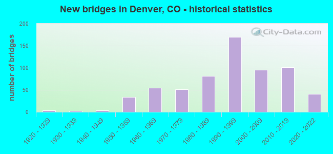
- New bridges - historical statistics
- 11910-1919
- 41920-1929
- 21930-1939
- 31940-1949
- 341950-1959
- 551960-1969
- 511970-1979
- 811980-1989
- 1701990-1999
- 952000-2009
- 1012010-2019
- 412020-2022
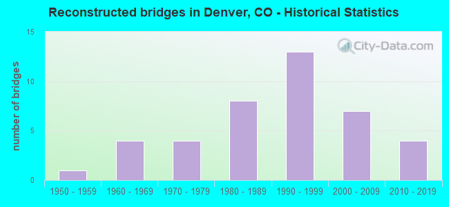
- Reconstructed bridges - Historical Statistics
- 11950-1959
- 41960-1969
- 41970-1979
- 81980-1989
- 131990-1999
- 72000-2009
- 42010-2019
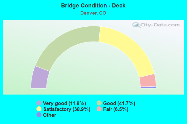
- Bridge Condition - Deck
- 11.8%Very good
- 41.7%Good
- 38.9%Satisfactory
- 6.5%Fair
- 1.0%Poor
- 0.3%Serious
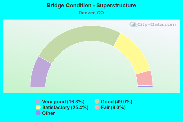
- Bridge Condition - Superstructure
- 16.8%Very good
- 49.0%Good
- 25.4%Satisfactory
- 8.0%Fair
- 0.8%Poor
- 0.3%Serious
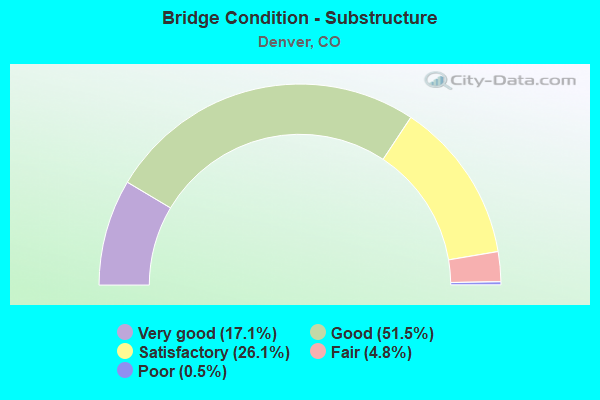
- Bridge Condition - Substructure
- 17.1%Very good
- 51.5%Good
- 26.1%Satisfactory
- 4.8%Fair
- 0.5%Poor
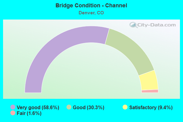
- Bridge Condition - Channel
- 58.6%Very good
- 30.3%Good
- 9.4%Satisfactory
- 1.6%Fair
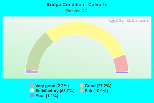
- Bridge Condition - Culverts
- 2.2%Very good
- 27.2%Good
- 58.7%Satisfactory
- 10.9%Fair
- 1.1%Poor
Find on map >> Show street view
Structure Number: D-13-HGE-16, Location: RACE ST AT E HARVARD AVE (Lat: 39.671203, Lng: -104.964100), Route carried "on" structure: City street , Year Built: 1967, Status: Open, Structure Length: 1.01m (3.31ft), Average Daily Traffic: 366 (year 2021), Truck Traffic: 2%, Average Future Daily Traffic: 407 (year 2041), Features Intersected: EAST HARVARD GULCH, Facility Carried by Structure: RACE ST
Minimum Vertical Clearance: 30+ m (98+ ft), Kilometerpoint: 0.401, Lanes on structure: 2, Owner: City or Municipal Highway Agency, Approaching Roadway Width: 11.0m (36.1ft), Material/Design: Concrete, Design/Construction: Slab, Number Of Spans In Main Unit: 1, Length of Maximum Span: 9.3m (30.5ft), Curb or Sidewalk Widths: Left: 1.5m (4.9ft), Right: 0.3m (1.0ft), Curb-To-Curb Width: 11.0m (36.1ft), Out-to-Out Width: 13.6m (44.6ft)
Condition: Deck: Good, Superstructure: Good, Substructure: Good, Channel: Satisfactory, Operating Rating: 32.7 metric tons, Method Used To Determine Operating Rating: Load Factor (LF), Inventory Rating: 19.6 metric tons, Method Used To Determine Inventory Rating: Load Factor (LF), Structural Evaluation: Somewhat better than minimum adequacy, Deck Geometry: Equal to present desirable criteria, Waterway Adequacy: Equal to present desirable criteria, Approach Roadway Alignment: Equal to present desirable criteria, Designated Inspection Frequency: Every 24 months, Inspection Date: November 2020, Deck Structure Type: Concrete Cast-file-Place, Wearing Surface/Protective System: Wearing Surface: Bituminous, Membrane: Built-up
Find on map >> Show street view
Structure Number: D-13-HGE-18, Location: YORK ST N OF VASSAR AVE (Lat: 39.669681, Lng: -104.960597), Route carried "on" structure: City street , Year Built: 1967, Status: Open, Structure Length: 2.10m (6.89ft), Average Daily Traffic: 735 (year 2021), Truck Traffic: 2%, Average Future Daily Traffic: 815 (year 2041), Features Intersected: EAST HARVARD GULCH, Facility Carried by Structure: YORK ST
Minimum Vertical Clearance: 30+ m (98+ ft), Kilometerpoint: 0.552, Lanes on structure: 2, Owner: City or Municipal Highway Agency, Approaching Roadway Width: 11.0m (36.1ft), Skew: 4 degrees, Material/Design: Concrete, Design/Construction: Culvert, Number Of Spans In Main Unit: 5, Length of Maximum Span: 3.9m (12.8ft), Curb or Sidewalk Widths: Left: 0.3m (1.0ft), Right: 1.5m (4.9ft), Curb-To-Curb Width: 11.0m (36.1ft), Out-to-Out Width: 13.6m (44.6ft)
Condition: Channel: Good, Culverts: Good, Operating Rating: 54.3 metric tons, Method Used To Determine Operating Rating: Load Factor (LF), Inventory Rating: 32.6 metric tons, Method Used To Determine Inventory Rating: Load Factor (LF), Structural Evaluation: Better than present minimum criteria, Deck Geometry: Better than present minimum criteria, Waterway Adequacy: Equal to present desirable criteria, Approach Roadway Alignment: Equal to present desirable criteria, Designated Inspection Frequency: Every 24 months, Inspection Date: November 2020, Deck Structure Type: Concrete Cast-file-Place, Wearing Surface/Protective System: Wearing Surface: Bituminous
Find on map >> Show street view
Structure Number: D-13-HGE-19, Location: UNIVERSITY AT VASSAR AVE (Lat: 39.669067, Lng: -104.959414), Route carried "on" structure: City street , Year Built: 1967, Status: Open, Structure Length: 2.10m (6.89ft), Average Daily Traffic: 27,146 (year 2021), Truck Traffic: 5%, Average Future Daily Traffic: 30,132 (year 2041), Features Intersected: EAST HARVARD GULCH, Facility Carried by Structure: UNIVERSITY BLVD
Minimum Vertical Clearance: 30+ m (98+ ft), Kilometerpoint: 4.617, Lanes on structure: 4, Base Highway Network: Yes, Owner: City or Municipal Highway Agency, Approaching Roadway Width: 13.4m (44.0ft), Skew: 4 degrees, Material/Design: Concrete, Design/Construction: Culvert, Number Of Spans In Main Unit: 5, Length of Maximum Span: 4.0m (13.1ft), Curb or Sidewalk Widths: Left: 1.5m (4.9ft), Right: 1.5m (4.9ft), Curb-To-Curb Width: 13.5m (44.3ft), Out-to-Out Width: 17.3m (56.8ft)
Condition: Channel: Satisfactory, Culverts: Fair, Operating Rating: 55.1 metric tons, Method Used To Determine Operating Rating: Load Factor (LF), Inventory Rating: 33.0 metric tons, Method Used To Determine Inventory Rating: Load Factor (LF), Structural Evaluation: Somewhat better than minimum adequacy, Deck Geometry: High priority of replacement, Waterway Adequacy: Better than present minimum criteria, Approach Roadway Alignment: Equal to present desirable criteria, Length Of Structure Improvement: 2.10m (6.89ft), Designated Inspection Frequency: Every 24 months, Inspection Date: November 2020, Bridge Improvement Cost: $338,000, Roadway Improvement Cost: $34,000, Total Project Cost: $372,000 ( Estimate for 2014), Deck Structure Type: Concrete Cast-file-Place, Wearing Surface/Protective System: Wearing Surface: Bituminous
Find on map >> Show street view
Structure Number: D-13-HGE-2, Location: JOSEPHINE ST N OF YALE AV (Lat: 39.668914, Lng: -104.957975), Route carried "on" structure: City street , Year Built: 1967, Status: Open, Structure Length: 1.61m (5.28ft), Average Daily Traffic: 405 (year 2021), Truck Traffic: 2%, Average Future Daily Traffic: 450 (year 2041), Features Intersected: EAST HARVARD GULCH, Facility Carried by Structure: JOSEPHINE ST
Minimum Vertical Clearance: 30+ m (98+ ft), Kilometerpoint: 1.622, Lanes on structure: 2, Owner: City or Municipal Highway Agency, Approaching Roadway Width: 12.2m (40.0ft), Material/Design: Concrete continuous, Design/Construction: Slab, Number Of Spans In Main Unit: 2, Length of Maximum Span: 7.5m (24.6ft), Curb or Sidewalk Widths: Left: 0.3m (1.0ft), Right: 1.5m (4.9ft), Curb-To-Curb Width: 13.4m (44.0ft), Out-to-Out Width: 16.0m (52.5ft)
Condition: Deck: Satisfactory, Superstructure: Satisfactory, Substructure: Satisfactory, Channel: Good, Operating Rating: 56.7 metric tons, Method Used To Determine Operating Rating: Load Factor (LF), Inventory Rating: 34.0 metric tons, Method Used To Determine Inventory Rating: Load Factor (LF), Structural Evaluation: Equal to present minimum criteria, Deck Geometry: Superior to present desirable criteria, Waterway Adequacy: Equal to present minimum criteria, Approach Roadway Alignment: Equal to present desirable criteria, Designated Inspection Frequency: Every 24 months, Inspection Date: November 2020, Deck Structure Type: Concrete Cast-file-Place, Wearing Surface/Protective System: Wearing Surface: Bituminous, Membrane: Built-up
Find on map >> Show street view
Structure Number: D-13-HGE-21, Location: COLUMBINE ST N OF YALE (Lat: 39.668706, Lng: -104.956550), Route carried "on" structure: City street , Year Built: 1967, Status: Open, Structure Length: 1.61m (5.28ft), Average Daily Traffic: 805 (year 2021), Truck Traffic: 2%, Average Future Daily Traffic: 893 (year 2041), Features Intersected: EAST HARVARD GULCH, Facility Carried by Structure: COLUMBINE ST
Minimum Vertical Clearance: 30+ m (98+ ft), Kilometerpoint: 1.651, Lanes on structure: 2, Owner: City or Municipal Highway Agency, Approaching Roadway Width: 11.0m (36.1ft), Material/Design: Concrete continuous, Design/Construction: Slab, Number Of Spans In Main Unit: 2, Length of Maximum Span: 7.5m (24.6ft), Curb or Sidewalk Widths: Left: 1.5m (4.9ft), Right: 0.3m (1.0ft), Curb-To-Curb Width: 11.0m (36.1ft), Out-to-Out Width: 13.6m (44.6ft)
Condition: Deck: Good, Superstructure: Good, Substructure: Satisfactory, Channel: Satisfactory, Operating Rating: 55.4 metric tons, Method Used To Determine Operating Rating: Load Factor (LF), Inventory Rating: 33.2 metric tons, Method Used To Determine Inventory Rating: Load Factor (LF), Structural Evaluation: Equal to present minimum criteria, Deck Geometry: Better than present minimum criteria, Waterway Adequacy: Equal to present desirable criteria, Approach Roadway Alignment: Equal to present desirable criteria, Designated Inspection Frequency: Every 24 months, Inspection Date: November 2020, Deck Structure Type: Concrete Cast-file-Place, Wearing Surface/Protective System: Wearing Surface: Bituminous, Membrane: Built-up
Find on map >> Show street view
Structure Number: D-13-HGE-23, Location: BTWN STEELE AND ADAMS (Lat: 39.669239, Lng: -104.949486), Route carried "on" structure: City street , Year Built: 1967, Status: Open, Structure Length: 1.45m (4.76ft), Average Daily Traffic: 75 (year 2021), Average Future Daily Traffic: 83 (year 2041), Features Intersected: EAST HARVARD GULCH, Facility Carried by Structure: ALLEY
Minimum Vertical Clearance: 30+ m (98+ ft), Kilometerpoint: 0.884, Lanes on structure: 1, Owner: City or Municipal Highway Agency, Approaching Roadway Width: 3.7m (12.1ft), Material/Design: Concrete continuous, Design/Construction: Slab, Number Of Spans In Main Unit: 2, Length of Maximum Span: 6.7m (22.0ft), Curb or Sidewalk Widths: Left: 0.3m (1.0ft), Right: 0.3m (1.0ft), Curb-To-Curb Width: 4.6m (15.1ft), Out-to-Out Width: 6.0m (19.7ft)
Condition: Deck: Good, Superstructure: Good, Substructure: Fair, Channel: Satisfactory, Operating Rating: 48.5 metric tons, Method Used To Determine Operating Rating: Load Factor (LF), Inventory Rating: 29.1 metric tons, Method Used To Determine Inventory Rating: Load Factor (LF), Structural Evaluation: Somewhat better than minimum adequacy, Deck Geometry: Better than present minimum criteria, Waterway Adequacy: Equal to present desirable criteria, Approach Roadway Alignment: Equal to present desirable criteria, Designated Inspection Frequency: Every 24 months, Inspection Date: September 2021, Deck Structure Type: Concrete Cast-file-Place, Wearing Surface/Protective System: Wearing Surface: Bituminous, Membrane: Built-up
Find on map >> Show street view
Structure Number: D-13-HGE-24, Location: ADAMS AND VASSAR AVE (Lat: 39.669392, Lng: -104.948889), Route carried "on" structure: City street , Year Built: 1967, Status: Open, Structure Length: 2.07m (6.79ft), Average Daily Traffic: 364 (year 2021), Truck Traffic: 2%, Average Future Daily Traffic: 404 (year 2041), Features Intersected: EAST HARVARD GULCH, Facility Carried by Structure: ADAMS ST
Minimum Vertical Clearance: 30+ m (98+ ft), Kilometerpoint: 0.933, Lanes on structure: 2, Owner: City or Municipal Highway Agency, Approaching Roadway Width: 11.0m (36.1ft), Skew: 4 degrees, Material/Design: Concrete, Design/Construction: Culvert, Number Of Spans In Main Unit: 6, Length of Maximum Span: 3.0m (9.8ft), Curb or Sidewalk Widths: Left: 0.8m (2.6ft), Right: 0.8m (2.6ft), Curb-To-Curb Width: 11.0m (36.1ft), Out-to-Out Width: 14.4m (47.2ft)
Condition: Channel: Good, Culverts: Good, Operating Rating: 35.4 metric tons, Method Used To Determine Operating Rating: Load Factor (LF), Inventory Rating: 21.2 metric tons, Method Used To Determine Inventory Rating: Load Factor (LF), Structural Evaluation: Equal to present minimum criteria, Deck Geometry: Equal to present desirable criteria, Waterway Adequacy: Equal to present desirable criteria, Approach Roadway Alignment: Equal to present desirable criteria, Designated Inspection Frequency: Every 24 months, Inspection Date: November 2020, Deck Structure Type: Concrete Cast-file-Place, Wearing Surface/Protective System: Wearing Surface: Bituminous
Find on map >> Show street view
Structure Number: D-13-HGE-25, Location: COOK N OF VASSAR AVE (Lat: 39.669769, Lng: -104.947714), Route carried "on" structure: City street , Year Built: 1967, Status: Open, Structure Length: 1.33m (4.36ft), Average Daily Traffic: 275 (year 2021), Truck Traffic: 2%, Average Future Daily Traffic: 305 (year 2041), Features Intersected: EAST HARVARD GULCH, Facility Carried by Structure: COOK ST
Minimum Vertical Clearance: 30+ m (98+ ft), Kilometerpoint: 0.555, Lanes on structure: 2, Owner: City or Municipal Highway Agency, Approaching Roadway Width: 9.1m (29.9ft), Skew: 1 degrees, Material/Design: Concrete continuous, Design/Construction: Slab, Number Of Spans In Main Unit: 2, Length of Maximum Span: 6.2m (20.3ft), Curb or Sidewalk Widths: Left: 0.3m (1.0ft), Right: 1.5m (4.9ft), Curb-To-Curb Width: 11.0m (36.1ft), Out-to-Out Width: 13.6m (44.6ft)
Condition: Deck: Good, Superstructure: Good, Substructure: Good, Channel: Satisfactory, Operating Rating: 48.2 metric tons, Method Used To Determine Operating Rating: Load Factor (LF), Inventory Rating: 28.8 metric tons, Method Used To Determine Inventory Rating: Load Factor (LF), Structural Evaluation: Better than present minimum criteria, Deck Geometry: Equal to present desirable criteria, Waterway Adequacy: Equal to present desirable criteria, Approach Roadway Alignment: Equal to present desirable criteria, Designated Inspection Frequency: Every 24 months, Inspection Date: November 2020, Deck Structure Type: Concrete Cast-file-Place, Wearing Surface/Protective System: Wearing Surface: Bituminous, Membrane: Built-up
Find on map >> Show street view
Structure Number: D-13-HGE-26, Location: MADISON ST N OF VASSAR AV (Lat: 39.669844, Lng: -104.946556), Route carried "on" structure: City street , Year Built: 1967, Status: Open, Structure Length: 1.15m (3.77ft), Average Daily Traffic: 334 (year 2021), Truck Traffic: 2%, Average Future Daily Traffic: 371 (year 2041), Features Intersected: EAST HARVARD GULCH, Facility Carried by Structure: MADISON ST
Minimum Vertical Clearance: 30.45m (99.90ft), Kilometerpoint: 0.933, Lanes on structure: 2, Owner: City or Municipal Highway Agency, Approaching Roadway Width: 9.1m (29.9ft), Material/Design: Concrete continuous, Design/Construction: Slab, Number Of Spans In Main Unit: 2, Length of Maximum Span: 5.2m (17.1ft), Curb or Sidewalk Widths: Left: 1.5m (4.9ft), Right: 0.3m (1.0ft), Curb-To-Curb Width: 11.0m (36.1ft), Out-to-Out Width: 13.6m (44.6ft)
Condition: Deck: Good, Superstructure: Good, Substructure: Satisfactory, Channel: Good, Operating Rating: 43.6 metric tons, Method Used To Determine Operating Rating: Load Factor (LF), Inventory Rating: 26.2 metric tons, Method Used To Determine Inventory Rating: Load Factor (LF), Structural Evaluation: Equal to present minimum criteria, Deck Geometry: Equal to present desirable criteria, Waterway Adequacy: Better than present minimum criteria, Approach Roadway Alignment: Equal to present desirable criteria, Designated Inspection Frequency: Every 24 months, Inspection Date: December 2020, Deck Structure Type: Concrete Cast-file-Place, Wearing Surface/Protective System: Wearing Surface: Bituminous, Membrane: Built-up
Find on map >> Show street view
Structure Number: D-13-HGE-27, Location: MONROE ST N OF VASSAR AVE (Lat: 39.669783, Lng: -104.945383), Route carried "on" structure: City street , Year Built: 1967, Status: Open, Structure Length: 1.19m (3.90ft), Average Daily Traffic: 538 (year 2021), Truck Traffic: 2%, Average Future Daily Traffic: 597 (year 2041), Features Intersected: EAST HARVARD GULCH, Facility Carried by Structure: MONROE ST
Minimum Vertical Clearance: 30.45m (99.90ft), Kilometerpoint: 1.584, Lanes on structure: 2, Owner: City or Municipal Highway Agency, Approaching Roadway Width: 9.1m (29.9ft), Skew: 1 degrees, Material/Design: Concrete continuous, Design/Construction: Slab, Number Of Spans In Main Unit: 2, Length of Maximum Span: 5.2m (17.1ft), Curb or Sidewalk Widths: Left: 1.5m (4.9ft), Right: 0.3m (1.0ft), Curb-To-Curb Width: 11.0m (36.1ft), Out-to-Out Width: 13.6m (44.6ft)
Condition: Deck: Good, Superstructure: Good, Substructure: Good, Channel: Good, Operating Rating: 40.3 metric tons, Method Used To Determine Operating Rating: Load Factor (LF), Inventory Rating: 24.1 metric tons, Method Used To Determine Inventory Rating: Load Factor (LF), Structural Evaluation: Equal to present minimum criteria, Deck Geometry: Better than present minimum criteria, Waterway Adequacy: Equal to present desirable criteria, Approach Roadway Alignment: Equal to present desirable criteria, Designated Inspection Frequency: Every 24 months, Inspection Date: December 2020, Deck Structure Type: Concrete Cast-file-Place, Wearing Surface/Protective System: Wearing Surface: Bituminous, Membrane: Built-up
Find on map >> Show street view
Structure Number: D-13-HGE-28, Location: JACKSON ST N OF EAST YALE (Lat: 39.669261, Lng: -104.943031), Route carried "on" structure: City street , Year Built: 1967, Status: Posted for load, Structure Length: 1.00m (3.28ft), Average Daily Traffic: 428 (year 2021), Truck Traffic: 2%, Average Future Daily Traffic: 475 (year 2041), Features Intersected: EAST HARVARD GULCH, Facility Carried by Structure: JACKSON ST
Minimum Vertical Clearance: 30.45m (99.90ft), Kilometerpoint: 0.615, Lanes on structure: 2, Owner: City or Municipal Highway Agency, Approaching Roadway Width: 11.0m (36.1ft), Material/Design: Concrete, Design/Construction: Slab, Number Of Spans In Main Unit: 1, Length of Maximum Span: 9.1m (29.9ft), Curb or Sidewalk Widths: Left: 0.3m (1.0ft), Right: 1.5m (4.9ft), Curb-To-Curb Width: 11.0m (36.1ft), Out-to-Out Width: 13.6m (44.6ft)
Condition: Deck: Good, Superstructure: Good, Substructure: Good, Channel: Satisfactory, Operating Rating: 29.2 metric tons, Method Used To Determine Operating Rating: Load Factor (LF), Inventory Rating: 17.5 metric tons, Method Used To Determine Inventory Rating: Load Factor (LF), Structural Evaluation: Somewhat better than minimum adequacy, Deck Geometry: Better than present minimum criteria, Waterway Adequacy: Better than present minimum criteria, Approach Roadway Alignment: Equal to present desirable criteria, Bridge Posting: Required (Relationship of Operating Rating to Maximum Legal Load: 0.1 - 9.9% below), Designated Inspection Frequency: Every 24 months, Inspection Date: December 2020, Deck Structure Type: Concrete Cast-file-Place, Wearing Surface/Protective System: Wearing Surface: Bituminous, Membrane: Built-up
Find on map >> Show street view
Structure Number: D-16-L, Location: @ 55TH ST NE OF BOULDER (Lat: 40.057031, Lng: -105.225731), Route carried "on" structure: State highway 119B, Year Built: 1958, Status: Open, Structure Length: 0.69m (2.26ft), Average Daily Traffic: 22,000 (year 2020), Truck Traffic: 3%, Average Future Daily Traffic: 25,520 (year 2040), Design Load: H 20, Features Intersected: BEASLEY DITCH, Facility Carried by Structure: SH 119 ML NB
Minimum Vertical Clearance: 30+ m (98+ ft), Kilometerpoint: 3.563, Lanes on structure: 4, Base Highway Network: Yes, Owner: State Highway Agency, Approaching Roadway Width: 11.6m (38.1ft), Skew: 4 degrees, Material/Design: Concrete, Design/Construction: Culvert, Number Of Spans In Main Unit: 1, Length of Maximum Span: 6.9m (22.6ft), Out-to-Out Width: 22.4m (73.5ft)
Condition: Channel: Satisfactory, Culverts: Satisfactory, Operating Rating: 36.3 metric tons, Method Used To Determine Operating Rating: Field evaluation and documented engineering judgment, Inventory Rating: 32.7 metric tons, Method Used To Determine Inventory Rating: Field evaluation and documented engineering judgment, Structural Evaluation: Equal to present minimum criteria, Waterway Adequacy: Equal to present minimum criteria, Approach Roadway Alignment: Equal to present desirable criteria, Designated Inspection Frequency: Every 24 months, Inspection Date: August 2021
Find on map >> Show street view
Structure Number: D-16-LG-020A, Location: JUST S OF 8TH AVE (Lat: 39.729122, Lng: -105.048542), Route carried "on" structure: City street , Year Built: 2013, Status: Open, Structure Length: 1.98m (6.50ft), Average Daily Traffic: 1,058 (year 2021), Truck Traffic: 5%, Average Future Daily Traffic: 1,175 (year 2041), Features Intersected: LAKEWOOD GULCH, Facility Carried by Structure: WOLFF STREET
Minimum Vertical Clearance: 30.45m (99.90ft), Kilometerpoint: 0.352, Lanes on structure: 2, Owner: City or Municipal Highway Agency, Approaching Roadway Width: 12.2m (40.0ft), Skew: 1 degrees, Material/Design: Concrete continuous, Design/Construction: Frame, Number Of Spans In Main Unit: 2, Length of Maximum Span: 8.9m (29.2ft), Curb or Sidewalk Widths: Left: 1.9m (6.2ft), Right: 1.9m (6.2ft), Curb-To-Curb Width: 12.2m (40.0ft), Out-to-Out Width: 16.8m (55.1ft)
Condition: Deck: Good, Superstructure: Good, Substructure: Very good, Channel: Very good, Operating Rating: 82.0 metric tons, Method Used To Determine Operating Rating: Load and Resistance Factor (LRFR), Inventory Rating: 63.2 metric tons, Method Used To Determine Inventory Rating: Load and Resistance Factor (LRFR), Structural Evaluation: Better than present minimum criteria, Deck Geometry: Better than present minimum criteria, Waterway Adequacy: Equal to present desirable criteria, Approach Roadway Alignment: Equal to present desirable criteria, Designated Inspection Frequency: Every 24 months, Inspection Date: October 2020, Deck Structure Type: Concrete Cast-file-Place, Wearing Surface/Protective System: Wearing Surface: Bituminous, Membrane: Built-up, Deck Protection: Epoxy Coated Reinforcing
Find on map >> Show street view
Structure Number: D-16-LG-030A, Location: 0.3 MI SOUTH OF 9TH ST (Lat: 39.729936, Lng: -105.043892), Route carried "on" structure: City street , Year Built: 2005, Status: Open, Structure Length: 1.73m (5.68ft), Average Daily Traffic: 2,166 (year 2021), Truck Traffic: 1%, Average Future Daily Traffic: 2,404 (year 2041), Design Load: HS 25 or greater, Features Intersected: LAKEWOOD GULCH, Facility Carried by Structure: TENNYSON STREET
Minimum Vertical Clearance: 30+ m (98+ ft), Kilometerpoint: 0.455, Lanes on structure: 2, Owner: City or Municipal Highway Agency, Approaching Roadway Width: 11.0m (36.1ft), Skew: 1 degrees, Material/Design: Concrete, Design/Construction: Frame, Number Of Spans In Main Unit: 1, Length of Maximum Span: 15.6m (51.2ft), Curb or Sidewalk Widths: Left: 1.9m (6.2ft), Right: 1.9m (6.2ft), Curb-To-Curb Width: 11.0m (36.1ft), Out-to-Out Width: 15.6m (51.2ft)
Condition: Deck: Good, Superstructure: Good, Substructure: Good, Channel: Very good, Operating Rating: 81.6 metric tons, Method Used To Determine Operating Rating: Load Factor (LF), Inventory Rating: 58.7 metric tons, Method Used To Determine Inventory Rating: Load Factor (LF), Structural Evaluation: Better than present minimum criteria, Deck Geometry: Somewhat better than minimum adequacy, Waterway Adequacy: Equal to present desirable criteria, Approach Roadway Alignment: Equal to present desirable criteria, Designated Inspection Frequency: Every 24 months, Inspection Date: October 2020, Deck Structure Type: Concrete Cast-file-Place, Wearing Surface/Protective System: Wearing Surface: Bituminous, Membrane: Built-up, Deck Protection: Epoxy Coated Reinforcing
Find on map >> Show street view
Structure Number: D-16-LG-060A, Location: .10 MI NORTH OF 9TH AVE (Lat: 39.731225, Lng: -105.039486), Route carried "on" structure: City street , Year Built: 2001, Status: Open, Structure Length: 1.71m (5.61ft), Average Daily Traffic: 5,422 (year 2021), Truck Traffic: 1%, Average Future Daily Traffic: 6,018 (year 2041), Design Load: HS 20, Features Intersected: LAKEWOOD GULCH, Facility Carried by Structure: PERRY STREET
Minimum Vertical Clearance: 30+ m (98+ ft), Kilometerpoint: 0.937, Lanes on structure: 2, Owner: City or Municipal Highway Agency, Approaching Roadway Width: 9.1m (29.9ft), Material/Design: Concrete, Design/Construction: Frame, Number Of Spans In Main Unit: 1, Length of Maximum Span: 15.2m (49.9ft), Curb or Sidewalk Widths: Left: 1.5m (4.9ft), Right: 1.5m (4.9ft), Curb-To-Curb Width: 9.1m (29.9ft), Out-to-Out Width: 12.8m (42.0ft)
Condition: Deck: Good, Superstructure: Good, Substructure: Good, Channel: Very good, Operating Rating: 80.9 metric tons, Method Used To Determine Operating Rating: Load Factor (LF), Inventory Rating: 48.5 metric tons, Method Used To Determine Inventory Rating: Load Factor (LF), Structural Evaluation: Better than present minimum criteria, Deck Geometry: High priority of corrective action, Waterway Adequacy: Equal to present desirable criteria, Approach Roadway Alignment: Equal to present desirable criteria, Designated Inspection Frequency: Every 24 months, Inspection Date: October 2020, Deck Structure Type: Concrete Cast-file-Place, Wearing Surface/Protective System: Wearing Surface: Bituminous, Membrane: Built-up, Deck Protection: Epoxy Coated Reinforcing
Find on map >> Show street view
Structure Number: D-16-LG-070A, Location: 0.1 MI EAST OF PERRY ST (Lat: 39.732981, Lng: -105.037897), Route carried "on" structure: City street , Year Built: 1999, Year Reconstructed: 2002, Status: Open, Structure Length: 1.65m (5.41ft), Average Daily Traffic: 5,422 (year 2021), Truck Traffic: 1%, Average Future Daily Traffic: 6,018 (year 2041), Design Load: HS 20, Features Intersected: LAKEWOOD GULCH, Facility Carried by Structure: 10TH AVENUE
Minimum Vertical Clearance: 30+ m (98+ ft), Kilometerpoint: 1.540, Lanes on structure: 2, Owner: City or Municipal Highway Agency, Approaching Roadway Width: 12.2m (40.0ft), Material/Design: Concrete continuous, Design/Construction: Frame, Number Of Spans In Main Unit: 2, Length of Maximum Span: 7.3m (24.0ft), Curb or Sidewalk Widths: Left: 1.9m (6.2ft), Right: 1.9m (6.2ft), Curb-To-Curb Width: 12.1m (39.7ft), Out-to-Out Width: 15.9m (52.2ft)
Condition: Deck: Good, Superstructure: Good, Substructure: Very good, Channel: Very good, Operating Rating: 81.6 metric tons, Method Used To Determine Operating Rating: Load Factor (LF), Inventory Rating: 80.4 metric tons, Method Used To Determine Inventory Rating: Load Factor (LF), Structural Evaluation: Better than present minimum criteria, Deck Geometry: Somewhat better than minimum adequacy, Waterway Adequacy: Equal to present desirable criteria, Approach Roadway Alignment: Equal to present desirable criteria, Designated Inspection Frequency: Every 24 months, Inspection Date: October 2020, Deck Structure Type: Concrete Cast-file-Place, Wearing Surface/Protective System: Wearing Surface: Bituminous, Membrane: Built-up, Deck Protection: Epoxy Coated Reinforcing
Find on map >> Show street view
Structure Number: D-16-LG-080A, Location: JUST N OF 12TH AVE (Lat: 39.734972, Lng: -105.032167), Route carried "on" structure: City street , Year Built: 2014, Status: Open, Structure Length: 1.88m (6.17ft), Average Daily Traffic: 3,320 (year 2021), Truck Traffic: 2%, Average Future Daily Traffic: 3,685 (year 2041), Design Load: HS 20, Features Intersected: LAKEWOOD GULCH, Facility Carried by Structure: KNOX COURT
Minimum Vertical Clearance: 30.45m (99.90ft), Kilometerpoint: 0.632, Lanes on structure: 2, Owner: City or Municipal Highway Agency, Approaching Roadway Width: 11.0m (36.1ft), Material/Design: Concrete, Design/Construction: Culvert, Number Of Spans In Main Unit: 3, Length of Maximum Span: 6.1m (20.0ft), Curb or Sidewalk Widths: Left: 7.6m (24.9ft), Right: 6.7m (22.0ft), Curb-To-Curb Width: 11.0m (36.1ft), Out-to-Out Width: 25.8m (84.6ft)
Condition: Channel: Very good, Culverts: Good, Operating Rating: 36.3 metric tons, Method Used To Determine Operating Rating: Field evaluation and documented engineering judgment, Inventory Rating: 32.7 metric tons, Method Used To Determine Inventory Rating: Field evaluation and documented engineering judgment, Structural Evaluation: Better than present minimum criteria, Deck Geometry: Somewhat better than minimum adequacy, Waterway Adequacy: Equal to present desirable criteria, Approach Roadway Alignment: Equal to present desirable criteria, Designated Inspection Frequency: Every 24 months, Inspection Date: October 2020
Find on map >> Show street view
Structure Number: D-16-LG-120A, Location: S DECATUR ST AT HOWARD PL (Lat: 39.737761, Lng: -105.021783), Route carried "on" structure: City street , Year Built: 2013, Status: Open, Structure Length: 5.06m (16.60ft), Average Daily Traffic: 4,940 (year 2021), Truck Traffic: 4%, Average Future Daily Traffic: 5,483 (year 2041), Design Load: HL 93, Features Intersected: LAKEWOOD GULCH, Facility Carried by Structure: DECATUR STREET
Minimum Vertical Clearance: 30.45m (99.90ft), Kilometerpoint: 0.935, Lanes on structure: 2, Owner: City or Municipal Highway Agency, Approaching Roadway Width: 12.2m (40.0ft), Skew: 22 degrees, Material/Design: Prestressed concrete, Design/Construction: Box Beam or Girders - Multiple, Number Of Spans In Main Unit: 3, Length of Maximum Span: 15.2m (49.9ft), Curb or Sidewalk Widths: Left: 3.2m (10.5ft), Right: 3.2m (10.5ft), Curb-To-Curb Width: 12.2m (40.0ft), Out-to-Out Width: 19.4m (63.6ft)
Condition: Deck: Good, Superstructure: Very good, Substructure: Very good, Channel: Very good, Operating Rating: 68.0 metric tons, Method Used To Determine Operating Rating: Load and Resistance Factor Rating (LRFR) rating reported by rating factor(RF) method using HL-93 loadings, Inventory Rating: 52.5 metric tons, Method Used To Determine Inventory Rating: Load and Resistance Factor Rating (LRFR) rating reported by rating factor(RF) method using HL-93 loadings, Structural Evaluation: Equal to present desirable criteria, Deck Geometry: Equal to present minimum criteria, Waterway Adequacy: Equal to present desirable criteria, Approach Roadway Alignment: Equal to present desirable criteria, Designated Inspection Frequency: Every 24 months, Inspection Date: October 2020, Deck Structure Type: Concrete Cast-file-Place, Wearing Surface/Protective System: Wearing Surface: Bituminous, Membrane: Built-up, Deck Protection: Epoxy Coated Reinforcing
Find on map >> Show street view
Structure Number: D-17-WG-02, Location: E OF SHERIDAN AT 600 BLOC (Lat: 39.705869, Lng: -105.048619), Route carried "on" structure: City street , Year Built: 1976, Status: Open, Structure Length: 0.88m (2.89ft), Average Daily Traffic: 754 (year 2021), Truck Traffic: 2%, Average Future Daily Traffic: 837 (year 2041), Design Load: HS 20, Features Intersected: WEIR GULCH, Facility Carried by Structure: WOLFF STREET
Minimum Vertical Clearance: 30.45m (99.90ft), Kilometerpoint: 0.541, Lanes on structure: 2, Owner: City or Municipal Highway Agency, Approaching Roadway Width: 11.0m (36.1ft), Skew: 4 degrees, Material/Design: Concrete, Design/Construction: Culvert, Number Of Spans In Main Unit: 2, Length of Maximum Span: 4.2m (13.8ft), Curb or Sidewalk Widths: Left: 1.2m (3.9ft), Right: 1.2m (3.9ft), Out-to-Out Width: 31.5m (103.3ft)
Condition: Channel: Very good, Culverts: Satisfactory, Operating Rating: 44.6 metric tons, Method Used To Determine Operating Rating: Load Factor (LF), Inventory Rating: 26.8 metric tons, Method Used To Determine Inventory Rating: Load Factor (LF), Structural Evaluation: Equal to present minimum criteria, Waterway Adequacy: Equal to present desirable criteria, Approach Roadway Alignment: Equal to present desirable criteria, Designated Inspection Frequency: Every 24 months, Inspection Date: January 2021
Find on map >> Show street view
Structure Number: D-17-WG-03, Location: E OF SHERIDAN AT 500 BLOC (Lat: 39.706592, Lng: -105.047817), Route carried "on" structure: City street , Year Built: 1976, Status: Open, Structure Length: 0.63m (2.07ft), Average Daily Traffic: 380 (year 2021), Truck Traffic: 2%, Average Future Daily Traffic: 422 (year 2041), Design Load: HS 20, Features Intersected: WEIR GULCH, Facility Carried by Structure: CUSTER PLACE
Minimum Vertical Clearance: 30.45m (99.90ft), Kilometerpoint: 0.387, Lanes on structure: 2, Owner: City or Municipal Highway Agency, Approaching Roadway Width: 10.1m (33.1ft), Material/Design: Concrete, Design/Construction: Culvert, Number Of Spans In Main Unit: 2, Length of Maximum Span: 3.0m (9.8ft), Curb or Sidewalk Widths: Left: 1.2m (3.9ft), Right: 1.2m (3.9ft), Curb-To-Curb Width: 10.1m (33.1ft), Out-to-Out Width: 19.2m (63.0ft)
Condition: Channel: Very good, Culverts: Satisfactory, Operating Rating: 26.5 metric tons, Method Used To Determine Operating Rating: Load Factor (LF), Inventory Rating: 15.9 metric tons, Method Used To Determine Inventory Rating: Load Factor (LF), Structural Evaluation: Meets minimum limits, Deck Geometry: Better than present minimum criteria, Waterway Adequacy: Equal to present desirable criteria, Approach Roadway Alignment: Equal to present desirable criteria, Designated Inspection Frequency: Every 24 months, Inspection Date: January 2021
Find on map >> Show street view
Structure Number: D-17-WG-04, Location: E OF SHERIDAN AT 500 BLOC (Lat: 39.707228, Lng: -105.048600), Route carried "on" structure: City street , Year Built: 1976, Status: Open, Structure Length: 0.63m (2.07ft), Average Daily Traffic: 443 (year 2021), Truck Traffic: 2%, Average Future Daily Traffic: 492 (year 2041), Design Load: HS 20, Features Intersected: WEIR GULCH, Facility Carried by Structure: WOLFF STREET
Minimum Vertical Clearance: 30+ m (98+ ft), Kilometerpoint: 0.389, Lanes on structure: 2, Owner: City or Municipal Highway Agency, Approaching Roadway Width: 11.0m (36.1ft), Material/Design: Concrete, Design/Construction: Culvert, Number Of Spans In Main Unit: 2, Length of Maximum Span: 3.0m (9.8ft), Curb or Sidewalk Widths: Left: 1.2m (3.9ft), Right: 1.2m (3.9ft), Out-to-Out Width: 23.2m (76.1ft)
Condition: Channel: Very good, Culverts: Good, Operating Rating: 42.7 metric tons, Method Used To Determine Operating Rating: Load Factor (LF), Inventory Rating: 25.7 metric tons, Method Used To Determine Inventory Rating: Load Factor (LF), Structural Evaluation: Equal to present minimum criteria, Waterway Adequacy: Equal to present desirable criteria, Approach Roadway Alignment: Equal to present desirable criteria, Designated Inspection Frequency: Every 24 months, Inspection Date: January 2021
Find on map >> Show street view
Structure Number: D-17-WG-05, Location: E OF SHERIDAN AT 500 BLOC (Lat: 39.707692, Lng: -105.049536), Route carried "on" structure: City street , Year Built: 1976, Status: Open, Structure Length: 0.63m (2.07ft), Average Daily Traffic: 564 (year 2021), Truck Traffic: 2%, Average Future Daily Traffic: 626 (year 2041), Design Load: HS 20, Features Intersected: WEIR GULCH, Facility Carried by Structure: VIRGINIA AVENUE
Minimum Vertical Clearance: 30+ m (98+ ft), Kilometerpoint: 0.084, Lanes on structure: 2, Owner: City or Municipal Highway Agency, Approaching Roadway Width: 11.0m (36.1ft), Material/Design: Concrete, Design/Construction: Culvert, Number Of Spans In Main Unit: 2, Length of Maximum Span: 3.0m (9.8ft), Curb or Sidewalk Widths: Left: 1.2m (3.9ft), Right: 1.2m (3.9ft), Out-to-Out Width: 27.4m (89.9ft)
Condition: Channel: Good, Culverts: Good, Operating Rating: 57.2 metric tons, Method Used To Determine Operating Rating: Load Factor (LF), Inventory Rating: 34.3 metric tons, Method Used To Determine Inventory Rating: Load Factor (LF), Structural Evaluation: Better than present minimum criteria, Waterway Adequacy: Equal to present desirable criteria, Approach Roadway Alignment: Equal to present desirable criteria, Designated Inspection Frequency: Every 24 months, Inspection Date: January 2021
Find on map >> Show street view
Structure Number: D-17-WG-07, Location: AT BAYAUD STREET (Lat: 39.715325, Lng: -105.044422), Route carried "on" structure: City street , Year Built: 1977, Status: Open, Structure Length: 1.34m (4.40ft), Average Daily Traffic: 651 (year 2021), Truck Traffic: 2%, Average Future Daily Traffic: 723 (year 2041), Design Load: HS 20, Features Intersected: WEIR GULCH, Facility Carried by Structure: UTICA ST
Minimum Vertical Clearance: 30.45m (99.90ft), Kilometerpoint: 0.138, Lanes on structure: 2, Owner: City or Municipal Highway Agency, Approaching Roadway Width: 11.0m (36.1ft), Skew: 5 degrees, Material/Design: Concrete, Design/Construction: Culvert, Number Of Spans In Main Unit: 2, Length of Maximum Span: 6.6m (21.7ft), Curb or Sidewalk Widths: Left: 1.0m (3.3ft), Right: 1.0m (3.3ft), Out-to-Out Width: 33.1m (108.6ft)
Condition: Channel: Very good, Culverts: Satisfactory, Operating Rating: 50.7 metric tons, Method Used To Determine Operating Rating: Load Factor (LF), Inventory Rating: 30.4 metric tons, Method Used To Determine Inventory Rating: Load Factor (LF), Structural Evaluation: Equal to present minimum criteria, Waterway Adequacy: Equal to present desirable criteria, Approach Roadway Alignment: Equal to present desirable criteria, Designated Inspection Frequency: Every 24 months, Inspection Date: January 2021
Find on map >> Show street view
Structure Number: D-17-WG-08, Location: BTWN RALEIGH/QUITMAN (Lat: 39.718161, Lng: -105.041719), Route carried "on" structure: City street , Year Built: 1977, Status: Open, Structure Length: 0.76m (2.49ft), Average Daily Traffic: 7,307 (year 2021), Truck Traffic: 4%, Average Future Daily Traffic: 8,110 (year 2041), Design Load: HS 20, Features Intersected: WEIR GULCH, Facility Carried by Structure: 1ST AVENUE
Minimum Vertical Clearance: 30.45m (99.90ft), Kilometerpoint: 1.370, Lanes on structure: 3, Owner: City or Municipal Highway Agency, Approaching Roadway Width: 14.6m (47.9ft), Skew: 1 degrees, Material/Design: Concrete, Design/Construction: Culvert, Number Of Spans In Main Unit: 2, Length of Maximum Span: 3.7m (12.1ft), Curb or Sidewalk Widths: Left: 1.5m (4.9ft), Right: 1.5m (4.9ft), Curb-To-Curb Width: 23.5m (77.1ft), Out-to-Out Width: 24.2m (79.4ft)
Condition: Channel: Very good, Culverts: Good, Operating Rating: 40.6 metric tons, Method Used To Determine Operating Rating: Load Factor (LF), Inventory Rating: 24.3 metric tons, Method Used To Determine Inventory Rating: Load Factor (LF), Structural Evaluation: Equal to present minimum criteria, Deck Geometry: Superior to present desirable criteria, Waterway Adequacy: Equal to present desirable criteria, Approach Roadway Alignment: Equal to present desirable criteria, Designated Inspection Frequency: Every 24 months, Inspection Date: January 2021
Find on map >> Show street view
Structure Number: D-17-WG-09, Location: NORTH OF 1ST AVENUE (Lat: 39.718719, Lng: -105.040922), Route carried "on" structure: City street , Year Built: 1976, Status: Open, Structure Length: 0.62m (2.03ft), Average Daily Traffic: 298 (year 2021), Truck Traffic: 2%, Average Future Daily Traffic: 331 (year 2041), Design Load: HS 20, Features Intersected: WEIR GULCH, Facility Carried by Structure: QUITMAN ST
Minimum Vertical Clearance: 30.45m (99.90ft), Kilometerpoint: 0.247, Lanes on structure: 2, Owner: City or Municipal Highway Agency, Approaching Roadway Width: 11.0m (36.1ft), Material/Design: Concrete, Design/Construction: Culvert, Number Of Spans In Main Unit: 1, Length of Maximum Span: 6.2m (20.3ft), Curb or Sidewalk Widths: Left: 1.5m (4.9ft), Right: 1.5m (4.9ft), Out-to-Out Width: 22.6m (74.1ft)
Condition: Channel: Good, Culverts: Satisfactory, Operating Rating: 37.3 metric tons, Method Used To Determine Operating Rating: Load Factor (LF), Inventory Rating: 22.3 metric tons, Method Used To Determine Inventory Rating: Load Factor (LF), Structural Evaluation: Equal to present minimum criteria, Waterway Adequacy: Equal to present desirable criteria, Approach Roadway Alignment: Equal to present desirable criteria, Designated Inspection Frequency: Every 24 months, Inspection Date: January 2021
Find on map >> Show street view
Structure Number: D-17-WG-1, Location: ALLEY E OF PERRY ST (Lat: 39.718764, Lng: -105.040322), Route carried "on" structure: City street , Year Built: 1976, Status: Open, Structure Length: 0.76m (2.49ft), Average Daily Traffic: 26 (year 2021), Average Future Daily Traffic: 29 (year 2041), Design Load: HS 20, Features Intersected: WEIR GULCH, Facility Carried by Structure: ALLEY
Minimum Vertical Clearance: 30.45m (99.90ft), Kilometerpoint: 0.000, Lanes on structure: 1, Owner: City or Municipal Highway Agency, Approaching Roadway Width: 3.4m (11.2ft), Skew: 4 degrees, Material/Design: Concrete, Design/Construction: Culvert, Number Of Spans In Main Unit: 1, Length of Maximum Span: 7.6m (24.9ft), Curb-To-Curb Width: 3.5m (11.5ft), Out-to-Out Width: 4.6m (15.1ft)
Condition: Channel: Very good, Culverts: Good, Operating Rating: 82.9 metric tons, Method Used To Determine Operating Rating: Load Factor (LF), Inventory Rating: 49.7 metric tons, Method Used To Determine Inventory Rating: Load Factor (LF), Structural Evaluation: Better than present minimum criteria, Deck Geometry: High priority of corrective action, Waterway Adequacy: Equal to present desirable criteria, Approach Roadway Alignment: Equal to present desirable criteria, Designated Inspection Frequency: Every 24 months, Inspection Date: January 2021
Find on map >> Show street view
Structure Number: D-17-WG-11, Location: NORTH OF 1ST AVENUE (Lat: 39.719311, Lng: -105.039719), Route carried "on" structure: City street , Year Built: 1976, Status: Open, Structure Length: 0.85m (2.79ft), Average Daily Traffic: 5,284 (year 2021), Truck Traffic: 4%, Average Future Daily Traffic: 5,865 (year 2041), Design Load: HS 20, Features Intersected: WEIR GULCH, Facility Carried by Structure: PERRY ST
Minimum Vertical Clearance: 30.45m (99.90ft), Kilometerpoint: 0.307, Lanes on structure: 2, Owner: City or Municipal Highway Agency, Approaching Roadway Width: 11.0m (36.1ft), Skew: 4 degrees, Material/Design: Concrete, Design/Construction: Culvert, Number Of Spans In Main Unit: 1, Length of Maximum Span: 8.5m (27.9ft), Curb or Sidewalk Widths: Left: 1.7m (5.6ft), Right: 1.7m (5.6ft), Curb-To-Curb Width: 35.1m (115.2ft), Out-to-Out Width: 35.8m (117.5ft)
Condition: Channel: Very good, Culverts: Satisfactory, Operating Rating: 74.1 metric tons, Method Used To Determine Operating Rating: Load Factor (LF), Inventory Rating: 44.5 metric tons, Method Used To Determine Inventory Rating: Load Factor (LF), Structural Evaluation: Equal to present minimum criteria, Deck Geometry: Superior to present desirable criteria, Waterway Adequacy: Equal to present desirable criteria, Approach Roadway Alignment: Equal to present desirable criteria, Designated Inspection Frequency: Every 24 months, Inspection Date: January 2021
Find on map >> Show street view
Structure Number: D-17-WG-15, Location: OSCEOLA TO KNOX CT (Lat: 39.720292, Lng: -105.032506), Route carried "on" structure: City street , Year Built: 1977, Status: Open, Structure Length: 0.63m (2.07ft), Average Daily Traffic: 7,461 (year 2021), Truck Traffic: 2%, Average Future Daily Traffic: 8,282 (year 2041), Features Intersected: WEIR GULCH, Facility Carried by Structure: MULTIPLE STREETS
Minimum Vertical Clearance: 30+ m (98+ ft), Kilometerpoint: 0.414, Lanes on structure: 12, Owner: City or Municipal Highway Agency, Approaching Roadway Width: 68.9m (226.0ft), Material/Design: Concrete, Design/Construction: Culvert, Number Of Spans In Main Unit: 2, Length of Maximum Span: 3.0m (9.8ft), Curb or Sidewalk Widths: Left: 1.5m (4.9ft), Right: 1.5m (4.9ft), Out-to-Out Width: 683.7m (2,243.1ft)
Condition: Channel: Good, Culverts: Satisfactory, Operating Rating: 33.0 metric tons, Method Used To Determine Operating Rating: Load Factor (LF), Inventory Rating: 19.8 metric tons, Method Used To Determine Inventory Rating: Load Factor (LF), Structural Evaluation: Somewhat better than minimum adequacy, Waterway Adequacy: Equal to present desirable criteria, Approach Roadway Alignment: Equal to present desirable criteria, Designated Inspection Frequency: Every 24 months, Inspection Date: January 2021
Find on map >> Show street view
Structure Number: D-17-WG-18, Location: AT 3RD AVENUE (Lat: 39.721386, Lng: -105.028853), Route carried "on" structure: City street , Year Built: 1979, Status: Open, Structure Length: 1.20m (3.94ft), Average Daily Traffic: 953 (year 2021), Truck Traffic: 2%, Average Future Daily Traffic: 1,058 (year 2041), Design Load: HS 20, Features Intersected: WEIR GULCH, Facility Carried by Structure: HOOKER ST
Minimum Vertical Clearance: 30+ m (98+ ft), Kilometerpoint: 0.536, Lanes on structure: 2, Owner: City or Municipal Highway Agency, Approaching Roadway Width: 11.0m (36.1ft), Skew: 2 degrees, Material/Design: Concrete, Design/Construction: Culvert, Number Of Spans In Main Unit: 3, Length of Maximum Span: 4.0m (13.1ft), Curb or Sidewalk Widths: Left: 1.4m (4.6ft), Right: 0.0m, Out-to-Out Width: 68.3m (224.1ft)
Condition: Channel: Good, Culverts: Satisfactory, Operating Rating: 38.4 metric tons, Method Used To Determine Operating Rating: Load Factor (LF), Inventory Rating: 23.0 metric tons, Method Used To Determine Inventory Rating: Load Factor (LF), Structural Evaluation: Equal to present minimum criteria, Waterway Adequacy: Equal to present desirable criteria, Approach Roadway Alignment: Equal to present desirable criteria, Designated Inspection Frequency: Every 24 months, Inspection Date: January 2021
Find on map >> Show street view
Structure Number: D-17-WG-2, Location: EAST OF FEDERAL BLVD (Lat: 39.729367, Lng: -105.024053), Route carried "on" structure: City street , Year Built: 1970, Status: Open, Structure Length: 0.87m (2.85ft), Average Daily Traffic: 13,064 (year 2021), Truck Traffic: 5%, Average Future Daily Traffic: 14,501 (year 2041), Features Intersected: WEIR GULCH, Facility Carried by Structure: WEST 8TH AVENUE
Minimum Vertical Clearance: 30.45m (99.90ft), Kilometerpoint: 7.166, Lanes on structure: 5, Owner: City or Municipal Highway Agency, Approaching Roadway Width: 18.6m (61.0ft), Skew: 6 degrees, Material/Design: Concrete, Design/Construction: Culvert, Number Of Spans In Main Unit: 1, Length of Maximum Span: 8.7m (28.5ft), Curb or Sidewalk Widths: Left: 4.7m (15.4ft), Right: 1.7m (5.6ft), Curb-To-Curb Width: 18.6m (61.0ft), Out-to-Out Width: 49.1m (161.1ft)
Condition: Channel: Very good, Culverts: Fair, Operating Rating: 36.3 metric tons, Method Used To Determine Operating Rating: Field evaluation and documented engineering judgment, Inventory Rating: 32.7 metric tons, Method Used To Determine Inventory Rating: Field evaluation and documented engineering judgment, Structural Evaluation: Somewhat better than minimum adequacy, Deck Geometry: High priority of corrective action, Waterway Adequacy: Equal to present desirable criteria, Approach Roadway Alignment: Equal to present desirable criteria, Designated Inspection Frequency: Every 24 months, Inspection Date: January 2021
Find on map >> Show street view
Structure Number: D-17-WG-211, Location: DECATUR BTWN BARBERRY/9TH (Lat: 39.730586, Lng: -105.021686), Route carried "on" structure: City street , Year Built: 1981, Status: Open, Structure Length: 0.87m (2.85ft), Average Daily Traffic: 5,426 (year 2021), Truck Traffic: 4%, Average Future Daily Traffic: 6,023 (year 2041), Features Intersected: WEIR GULCH, Facility Carried by Structure: DECATUR STREET
Minimum Vertical Clearance: 30.45m (99.90ft), Kilometerpoint: 0.143, Lanes on structure: 2, Owner: City or Municipal Highway Agency, Approaching Roadway Width: 13.4m (44.0ft), Skew: 3 degrees, Material/Design: Concrete, Design/Construction: Culvert, Number Of Spans In Main Unit: 2, Length of Maximum Span: 4.2m (13.8ft), Curb or Sidewalk Widths: Left: 1.7m (5.6ft), Right: 1.5m (4.9ft), Out-to-Out Width: 152.4m (500.0ft)
Condition: Channel: Good, Culverts: Satisfactory, Operating Rating: 75.4 metric tons, Method Used To Determine Operating Rating: Load Factor (LF), Inventory Rating: 45.2 metric tons, Method Used To Determine Inventory Rating: Load Factor (LF), Structural Evaluation: Equal to present minimum criteria, Waterway Adequacy: Equal to present desirable criteria, Approach Roadway Alignment: Equal to present desirable criteria, Designated Inspection Frequency: Every 24 months, Inspection Date: January 2021
Find on map >> Show street view
Structure Number: D-19-S, Location: JUST NE OF ROGGEN (Lat: 40.170803, Lng: -104.352992), Route carried "on" structure: Interstate 76A, Year Built: 1959, Status: Open, Structure Length: 0.61m (2.00ft), Average Daily Traffic: 6,000 (year 2020), Truck Traffic: 19%, Average Future Daily Traffic: 8,160 (year 2040), Design Load: H 20, Features Intersected: COUNTY ROADS 386,24.4, Facility Carried by Structure: I 76 ML EBND
Minimum Vertical Clearance: 30+ m (98+ ft), Kilometerpoint: 79.225, Lanes on structure: 2, Lanes under structure: 2, Base Highway Network: Yes, Owner: State Highway Agency, Approaching Roadway Width: 11.6m (38.1ft), Skew: 10 degrees, Material/Design: Concrete, Design/Construction: Culvert, Number Of Spans In Main Unit: 1, Length of Maximum Span: 6.1m (20.0ft), Curb-To-Curb Width: 12.2m (40.0ft), Out-to-Out Width: 14.0m (45.9ft)
Condition: Culverts: Satisfactory, Operating Rating: 36.3 metric tons, Method Used To Determine Operating Rating: Field evaluation and documented engineering judgment, Inventory Rating: 32.7 metric tons, Method Used To Determine Inventory Rating: Field evaluation and documented engineering judgment, Structural Evaluation: Equal to present minimum criteria, Deck Geometry: Better than present minimum criteria, Underclear: High priority of corrective action, Approach Roadway Alignment: Equal to present desirable criteria, Designated Inspection Frequency: Every 24 months, Inspection Date: Febuary 2021
Find on map >> Show street view
Structure Number: D-19-SC-010A, Location: AT SAND CREEK DR (Lat: 39.782964, Lng: -104.902994), Route carried "on" structure: City street , Year Built: 2010, Status: Open, Structure Length: 6.19m (20.31ft), Average Daily Traffic: 4,909 (year 2021), Truck Traffic: 10%, Average Future Daily Traffic: 5,449 (year 2041), Design Load: HL 93, Features Intersected: SAND CREEK, Facility Carried by Structure: 47TH AVE
Minimum Vertical Clearance: 30.45m (99.90ft), Kilometerpoint: 0.877, Lanes on structure: 2, Owner: City or Municipal Highway Agency, Approaching Roadway Width: 12.2m (40.0ft), Material/Design: Prestressed concrete continuous, Design/Construction: Box Beam or Girders - Multiple, Number Of Spans In Main Unit: 3, Length of Maximum Span: 19.4m (63.6ft), Curb or Sidewalk Widths: Left: 1.5m (4.9ft), Right: 2.4m (7.9ft), Curb-To-Curb Width: 9.8m (32.2ft), Out-to-Out Width: 14.6m (47.9ft)
Condition: Deck: Good, Superstructure: Good, Substructure: Very good, Channel: Good, Operating Rating: 87.2 metric tons, Method Used To Determine Operating Rating: Load and Resistance Factor Rating (LRFR) rating reported by rating factor(RF) method using HL-93 loadings, Inventory Rating: 55.1 metric tons, Method Used To Determine Inventory Rating: Load and Resistance Factor Rating (LRFR) rating reported by rating factor(RF) method using HL-93 loadings, Structural Evaluation: Better than present minimum criteria, Deck Geometry: Meets minimum limits, Waterway Adequacy: Equal to present desirable criteria, Approach Roadway Alignment: Equal to present desirable criteria, Designated Inspection Frequency: Every 24 months, Inspection Date: January 2021, Deck Structure Type: Concrete Cast-file-Place, Wearing Surface/Protective System: Wearing Surface: Bituminous, Membrane: Preformed Fabric, Deck Protection: Epoxy Coated Reinforcing
Find on map >> Show street view
Structure Number: D-19-SC-03, Location: 0.9 MI E OF QUEBEC (Lat: 39.770019, Lng: -104.886261), Route carried "on" structure: City street , Year Built: 1955, Status: Closed, Structure Length: 9.45m (31.00ft), Truck Traffic: 2%, Features Intersected: SAND CREEK, Facility Carried by Structure: SMITH ROAD
Minimum Vertical Clearance: 30+ m (98+ ft), Kilometerpoint: 0.000, Lanes on structure: 2, Owner: City or Municipal Highway Agency, Approaching Roadway Width: 9.1m (29.9ft), Skew: 3 degrees, Material/Design: Concrete, Design/Construction: Tee Beam, Number Of Spans In Main Unit: 10, Length of Maximum Span: 9.1m (29.9ft), Curb or Sidewalk Widths: Left: 0.6m (2.0ft), Right: 0.6m (2.0ft), Curb-To-Curb Width: 9.1m (29.9ft), Out-to-Out Width: 10.4m (34.1ft)
Condition: Deck: Fair, Superstructure: Satisfactory, Substructure: Fair, Channel: Satisfactory, Operating Rating: 34.7 metric tons, Method Used To Determine Operating Rating: Load Factor (LF), Inventory Rating: 20.9 metric tons, Method Used To Determine Inventory Rating: Load Factor (LF), Structural Evaluation: Somewhat better than minimum adequacy, Deck Geometry: Better than present minimum criteria, Waterway Adequacy: Better than present minimum criteria, Approach Roadway Alignment: Equal to present desirable criteria, Designated Inspection Frequency: Every 24 months, Inspection Date: January 2022, Deck Structure Type: Concrete Cast-file-Place, Wearing Surface/Protective System: Wearing Surface: Bituminous
Find on map >> Show street view
Structure Number: D-19-SC-050A, Location: 0.3 MI S OF SMITH ROAD (Lat: 39.763625, Lng: -104.865897), Route carried "on" structure: City street , Year Built: 1989, Status: Open, Structure Length: 9.16m (30.05ft), Average Daily Traffic: 13,787 (year 2021), Truck Traffic: 4%, Average Future Daily Traffic: 15,303 (year 2041), Design Load: HS 20, Features Intersected: SAND CREEK, Facility Carried by Structure: HAVANA ST
Minimum Vertical Clearance: 30.45m (99.90ft), Kilometerpoint: 0.145, Lanes on structure: 2, Owner: City or Municipal Highway Agency, Approaching Roadway Width: 8.5m (27.9ft), Material/Design: Prestressed concrete continuous, Design/Construction: Slab, Number Of Spans In Main Unit: 4, Length of Maximum Span: 25.5m (83.7ft), Curb or Sidewalk Widths: Left: 2.7m (8.9ft), Right: 0.0m, Curb-To-Curb Width: 8.5m (27.9ft), Out-to-Out Width: 11.9m (39.0ft)
Condition: Deck: Good, Superstructure: Good, Substructure: Good, Channel: Good, Inventory Rating: 74.4 metric tons, Method Used To Determine Inventory Rating: Load Factor (LF), Structural Evaluation: Better than present minimum criteria, Deck Geometry: Meets minimum limits, Waterway Adequacy: Equal to present desirable criteria, Approach Roadway Alignment: Equal to present desirable criteria, Designated Inspection Frequency: Every 24 months, Inspection Date: January 2021, Deck Structure Type: Concrete Cast-file-Place, Wearing Surface/Protective System: Wearing Surface: Bituminous, Membrane: Built-up, Deck Protection: Epoxy Coated Reinforcing
Find on map >> Show street view
Structure Number: D-20-MB-332, Location: JUST WEST OF HAVANA ST (Lat: 39.790089, Lng: -104.866400), Route carried "on" structure: City street , Year Built: 1995, Status: Open, Structure Length: 0.88m (2.89ft), Average Daily Traffic: 3,953 (year 2021), Truck Traffic: 2%, Average Future Daily Traffic: 4,388 (year 2041), Features Intersected: MONTBELLO DITCH, Facility Carried by Structure: 51ST AVENUE
Minimum Vertical Clearance: 30.45m (99.90ft), Kilometerpoint: 1.368, Lanes on structure: 5, Owner: City or Municipal Highway Agency, Approaching Roadway Width: 21.3m (69.9ft), Skew: 30 degrees, Material/Design: Concrete, Design/Construction: Culvert, Number Of Spans In Main Unit: 2, Length of Maximum Span: 4.3m (14.1ft), Curb or Sidewalk Widths: Left: 1.5m (4.9ft), Right: 1.5m (4.9ft), Out-to-Out Width: 67.1m (220.1ft)
Condition: Channel: Fair, Culverts: Good, Structural Evaluation: Better than present minimum criteria, Waterway Adequacy: Equal to present desirable criteria, Approach Roadway Alignment: Equal to present desirable criteria, Designated Inspection Frequency: Every 24 months, Inspection Date: December 2020
Find on map >> Show street view
Structure Number: D-20-MB-335, Location: JUST WEST OF HAVANA (Lat: 39.786683, Lng: -104.866294), Route carried "on" structure: City street , Year Built: 2001, Status: Open, Structure Length: 0.76m (2.49ft), Average Daily Traffic: 1,932 (year 2021), Truck Traffic: 4%, Average Future Daily Traffic: 2,145 (year 2041), Design Load: HS 20, Features Intersected: MONTBELLO DITCH, Facility Carried by Structure: 49TH AVENUE
Minimum Vertical Clearance: 30.45m (99.90ft), Kilometerpoint: 0.763, Lanes on structure: 2, Owner: City or Municipal Highway Agency, Approaching Roadway Width: 13.4m (44.0ft), Material/Design: Concrete, Design/Construction: Culvert, Number Of Spans In Main Unit: 2, Length of Maximum Span: 3.7m (12.1ft), Curb or Sidewalk Widths: Left: 1.5m (4.9ft), Right: 1.5m (4.9ft), Curb-To-Curb Width: 13.4m (44.0ft), Out-to-Out Width: 38.0m (124.7ft)
Condition: Channel: Good, Culverts: Satisfactory, Structural Evaluation: Equal to present minimum criteria, Deck Geometry: Equal to present desirable criteria, Waterway Adequacy: Equal to present desirable criteria, Approach Roadway Alignment: Equal to present desirable criteria, Designated Inspection Frequency: Every 24 months, Inspection Date: December 2020
Find on map >> Show street view
Structure Number: D-20-MB-337, Location: JUST WEST OF HAVANA (Lat: 39.784214, Lng: -104.866211), Route carried "on" structure: City street , Year Built: 2001, Status: Open, Structure Length: 0.76m (2.49ft), Average Daily Traffic: 869 (year 2021), Truck Traffic: 4%, Average Future Daily Traffic: 965 (year 2041), Design Load: HS 20, Features Intersected: MONTBELLO DITCH, Facility Carried by Structure: 48TH AVENUE
Minimum Vertical Clearance: 30.45m (99.90ft), Kilometerpoint: 0.220, Lanes on structure: 2, Owner: City or Municipal Highway Agency, Approaching Roadway Width: 13.4m (44.0ft), Material/Design: Concrete, Design/Construction: Culvert, Number Of Spans In Main Unit: 2, Length of Maximum Span: 3.7m (12.1ft), Curb or Sidewalk Widths: Left: 1.5m (4.9ft), Right: 1.5m (4.9ft), Curb-To-Curb Width: 13.4m (44.0ft), Out-to-Out Width: 37.8m (124.0ft)
Condition: Channel: Good, Culverts: Satisfactory, Structural Evaluation: Equal to present minimum criteria, Deck Geometry: Superior to present desirable criteria, Waterway Adequacy: Equal to present desirable criteria, Approach Roadway Alignment: Equal to present desirable criteria, Designated Inspection Frequency: Every 24 months, Inspection Date: December 2020
Find on map >> Show street view
Structure Number: D-20-MB-43, Location: PEORIA AT 49TH (Lat: 39.786319, Lng: -104.847103), Route carried "on" structure: City street , Year Built: 1964, Status: Open, Structure Length: 0.62m (2.03ft), Average Daily Traffic: 23,175 (year 2021), Truck Traffic: 5%, Average Future Daily Traffic: 25,724 (year 2041), Features Intersected: MONTBELLO DITCH, Facility Carried by Structure: PEORIA ST
Minimum Vertical Clearance: 30.45m (99.90ft), Kilometerpoint: 2.021, Lanes on structure: 6, Owner: City or Municipal Highway Agency, Approaching Roadway Width: 25.6m (84.0ft), Material/Design: Concrete, Design/Construction: Culvert, Number Of Spans In Main Unit: 3, Length of Maximum Span: 2.0m (6.6ft), Curb or Sidewalk Widths: Left: 1.5m (4.9ft), Right: 1.5m (4.9ft), Curb-To-Curb Width: 25.6m (84.0ft), Out-to-Out Width: 39.6m (129.9ft)
Condition: Channel: Good, Culverts: Good, Operating Rating: 36.3 metric tons, Method Used To Determine Operating Rating: Field evaluation and documented engineering judgment, Inventory Rating: 32.7 metric tons, Method Used To Determine Inventory Rating: Field evaluation and documented engineering judgment, Structural Evaluation: Better than present minimum criteria, Deck Geometry: Somewhat better than minimum adequacy, Waterway Adequacy: Equal to present minimum criteria, Approach Roadway Alignment: Equal to present desirable criteria, Designated Inspection Frequency: Every 24 months, Inspection Date: December 2020
Find on map >> Show street view
Structure Number: D-20-MB-64, Location: AT 46TH AVENUE (Lat: 39.776678, Lng: -104.809969), Route carried "on" structure: City street , Year Built: 1980, Year Reconstructed: 2000, Status: Open, Structure Length: 0.64m (2.10ft), Average Daily Traffic: 31,946 (year 2021), Truck Traffic: 2%, Average Future Daily Traffic: 35,460 (year 2041), Features Intersected: MONTBELLO DITCH, Facility Carried by Structure: CHAMBERS ROAD
Minimum Vertical Clearance: 30.45m (99.90ft), Kilometerpoint: 0.435, Lanes on structure: 6, Owner: City or Municipal Highway Agency, Approaching Roadway Width: 21.9m (71.9ft), Material/Design: Concrete, Design/Construction: Culvert, Number Of Spans In Main Unit: 3, Length of Maximum Span: 1.8m (5.9ft), Curb or Sidewalk Widths: Left: 5.1m (16.7ft), Right: 1.5m (4.9ft), Curb-To-Curb Width: 26.3m (86.3ft), Out-to-Out Width: 48.5m (159.1ft)
Condition: Channel: Good, Culverts: Satisfactory, Operating Rating: 36.3 metric tons, Method Used To Determine Operating Rating: Field evaluation and documented engineering judgment, Inventory Rating: 32.7 metric tons, Method Used To Determine Inventory Rating: Field evaluation and documented engineering judgment, Structural Evaluation: Equal to present minimum criteria, Deck Geometry: Equal to present minimum criteria, Waterway Adequacy: Equal to present desirable criteria, Approach Roadway Alignment: Equal to present desirable criteria, Designated Inspection Frequency: Every 24 months, Inspection Date: December 2020
Find on map >> Show street view
Structure Number: D-20-MB-692, Location: JUST WEST OF HAVANA (Lat: 39.782197, Lng: -104.866217), Route carried "on" structure: City street , Year Built: 1999, Status: Open, Structure Length: 0.76m (2.49ft), Average Daily Traffic: 5,449 (year 2021), Truck Traffic: 4%, Average Future Daily Traffic: 6,049 (year 2041), Design Load: HS 20, Features Intersected: MONTBELLO DITCH, Facility Carried by Structure: 47TH AVENUE
Minimum Vertical Clearance: 30.45m (99.90ft), Kilometerpoint: 0.850, Lanes on structure: 5, Owner: City or Municipal Highway Agency, Approaching Roadway Width: 20.0m (65.6ft), Skew: 20 degrees, Material/Design: Concrete, Design/Construction: Culvert, Number Of Spans In Main Unit: 2, Length of Maximum Span: 3.7m (12.1ft), Curb or Sidewalk Widths: Left: 1.5m (4.9ft), Right: 1.5m (4.9ft), Out-to-Out Width: 53.7m (176.2ft)
Condition: Channel: Good, Culverts: Satisfactory, Operating Rating: 87.4 metric tons, Method Used To Determine Operating Rating: Load Factor (LF), Inventory Rating: 52.4 metric tons, Method Used To Determine Inventory Rating: Load Factor (LF), Structural Evaluation: Equal to present minimum criteria, Waterway Adequacy: Equal to present desirable criteria, Approach Roadway Alignment: Equal to present desirable criteria, Designated Inspection Frequency: Every 24 months, Inspection Date: December 2020
Find on map >> Show street view
Structure Number: D-20-MB-785, Location: JUST W OF HAVANA ST (Lat: 39.798436, Lng: -104.866461), Route carried "on" structure: City street , Year Built: 1995, Status: Open, Structure Length: 1.58m (5.18ft), Average Daily Traffic: 15,700 (year 2021), Truck Traffic: 6%, Average Future Daily Traffic: 17,427 (year 2041), Features Intersected: MONTBELLO DITCH, Facility Carried by Structure: EASTBOUND 56TH AVE
Minimum Vertical Clearance: 30.45m (99.90ft), Kilometerpoint: 1.535, Lanes on structure: 4, Owner: City or Municipal Highway Agency, Approaching Roadway Width: 18.3m (60.0ft), Skew: 20 degrees, Material/Design: Prestressed concrete, Design/Construction: Slab, Number Of Spans In Main Unit: 1, Length of Maximum Span: 14.0m (45.9ft), Curb or Sidewalk Widths: Left: 2.7m (8.9ft), Right: 0.0m, Curb-To-Curb Width: 18.3m (60.0ft), Out-to-Out Width: 22.8m (74.8ft)
Condition: Deck: Satisfactory, Superstructure: Satisfactory, Substructure: Good, Channel: Good, Operating Rating: 63.5 metric tons, Method Used To Determine Operating Rating: Load Factor (LF), Inventory Rating: 38.1 metric tons, Method Used To Determine Inventory Rating: Load Factor (LF), Structural Evaluation: Equal to present minimum criteria, Deck Geometry: Somewhat better than minimum adequacy, Waterway Adequacy: Equal to present desirable criteria, Approach Roadway Alignment: Equal to present desirable criteria, Designated Inspection Frequency: Every 24 months, Inspection Date: October 2020, Deck Structure Type: Concrete Cast-file-Place, Wearing Surface/Protective System: Wearing Surface: Bituminous, Membrane: Built-up