Bridge Statistics for Huntsville, Alabama (AL)
Condition, Traffic, Stress, Structural Evaluation, Project Costs
- National Bridge Inventory (NBI) Statistics
- 639Number of bridges
- 11,867ft / 3,617mTotal length
- $1,521,431,000Total costs
- 10,240,811Total average daily traffic
- 528,271Total average daily truck traffic
- National Bridge Inventory (NBI) Registered Bridges for Huntsville
- No street view available for this location
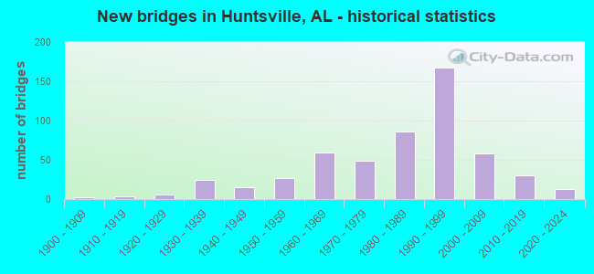
- New bridges - historical statistics
- 21900-1909
- 31910-1919
- 131920-1929
- 381930-1939
- 241940-1949
- 421950-1959
- 711960-1969
- 551970-1979
- 1011980-1989
- 1771990-1999
- 662000-2009
- 352010-2019
- 122020-2022
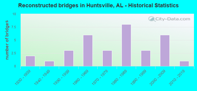
- Reconstructed bridges - Historical Statistics
- 21930-1939
- 11940-1949
- 31950-1959
- 61960-1969
- 31970-1979
- 81980-1989
- 31990-1999
- 62000-2009
- 12010-2019
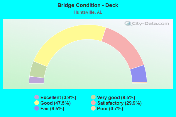
- Bridge Condition - Deck
- 3.9%Excellent
- 8.5%Very good
- 47.5%Good
- 29.9%Satisfactory
- 9.5%Fair
- 0.7%Poor
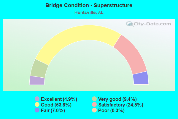
- Bridge Condition - Superstructure
- 4.9%Excellent
- 9.4%Very good
- 53.8%Good
- 24.5%Satisfactory
- 7.0%Fair
- 0.3%Poor
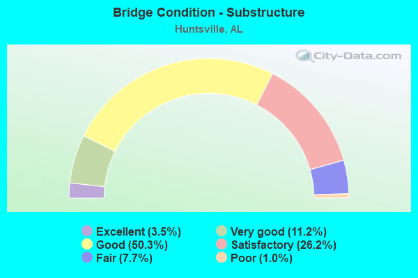
- Bridge Condition - Substructure
- 3.5%Excellent
- 11.2%Very good
- 50.3%Good
- 26.2%Satisfactory
- 7.7%Fair
- 1.0%Poor
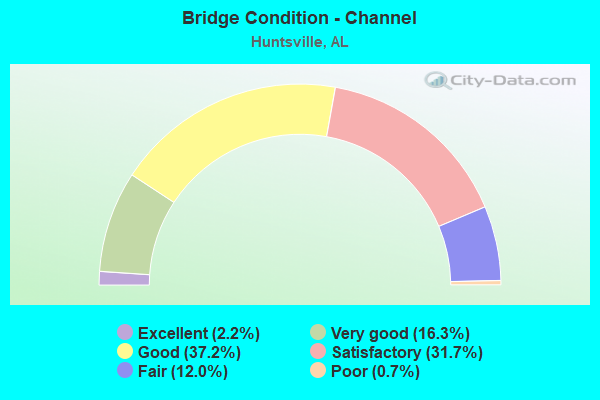
- Bridge Condition - Channel
- 2.2%Excellent
- 16.3%Very good
- 37.2%Good
- 31.7%Satisfactory
- 12.0%Fair
- 0.7%Poor
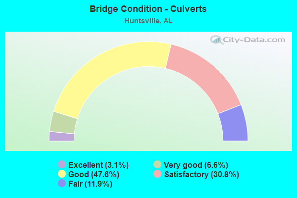
- Bridge Condition - Culverts
- 3.1%Excellent
- 6.6%Very good
- 47.6%Good
- 30.8%Satisfactory
- 11.9%Fair
Find on map >> Show street view
Structure Number: 2157, Location: 1.1 mi E Gbrier Pkwy (Lat: 34.669978, Lng: -86.822917), Route carried "on" structure: City street 1382, Year Built: 2020, Status: Open, Structure Length: 7.77m (25.49ft), Average Daily Traffic: 3,328 (year 2020), Truck Traffic: 2%, Average Future Daily Traffic: 15,200 (year 2040), Design Load: HL 93, Features Intersected: Beaverdam Creek, Facility Carried by Structure: Old Hwy 20
Minimum Vertical Clearance: 30+ m (98+ ft), Kilometerpoint: 0.000, Lanes on structure: 5, Owner: City or Municipal Highway Agency, Approaching Roadway Width: 20.7m (67.9ft), Skew: 7 degrees, Material/Design: Concrete, Design/Construction: Stringer/Multi-beam, Number Of Spans In Main Unit: 3, Length of Maximum Span: 25.9m (85.0ft), Curb or Sidewalk Widths: Left: 1.5m (4.9ft), Right: 1.5m (4.9ft), Curb-To-Curb Width: 20.7m (67.9ft), Out-to-Out Width: 26.3m (86.3ft)
Condition: Deck: Very good, Superstructure: Very good, Substructure: Very good, Channel: Very good, Operating Rating: 77.1 metric tons, Method Used To Determine Operating Rating: Load and Resistance Factor Rating (LRFR) rating reported by rating factor(RF) method using HL-93 loadings, Inventory Rating: 57.3 metric tons, Method Used To Determine Inventory Rating: Load and Resistance Factor Rating (LRFR) rating reported by rating factor(RF) method using HL-93 loadings, Structural Evaluation: Equal to present desirable criteria, Deck Geometry: Somewhat better than minimum adequacy, Waterway Adequacy: Better than present minimum criteria, Approach Roadway Alignment: Better than present minimum criteria, Length Of Structure Improvement: 8.79m (28.84ft), Designated Inspection Frequency: Every 24 months, Inspection Date: May 2021, Bridge Improvement Cost: $5,182,000, Roadway Improvement Cost: $518,000, Total Project Cost: $5,700,000 ( Estimate for 2022), Deck Structure Type: Concrete Cast-file-Place, Wearing Surface/Protective System: Wearing Surface: Monolithic Concrete
Find on map >> Show street view
Structure Number: 21571, Location: 1 mi E Greenbrier Pkwy (Lat: 34.669767, Lng: -86.829472), Route carried "on" structure: City street 1382, Year Built: 2020, Status: Open, Structure Length: 12.80m (41.99ft), Average Daily Traffic: 3,328 (year 2020), Truck Traffic: 1%, Average Future Daily Traffic: 15,200 (year 2040), Design Load: HL 93, Features Intersected: _Norfolk Southern RR, Facility Carried by Structure: _Old Hwy 20
Minimum Vertical Clearance: 30+ m (98+ ft), Kilometerpoint: 0.000, Lanes on structure: 4, Owner: City or Municipal Highway Agency, Approaching Roadway Width: 20.7m (67.9ft), Skew: 5 degrees, Material/Design: Concrete, Design/Construction: Stringer/Multi-beam, Number Of Spans In Main Unit: 3, Length of Maximum Span: 44.2m (145.0ft), Curb or Sidewalk Widths: Left: 1.5m (4.9ft), Right: 1.5m (4.9ft), Curb-To-Curb Width: 21.8m (71.5ft), Out-to-Out Width: 26.3m (86.3ft)
Condition: Deck: Very good, Superstructure: Very good, Substructure: Very good, Channel: Very good, Operating Rating: 81.2 metric tons, Method Used To Determine Operating Rating: Load and Resistance Factor (LRFR), Inventory Rating: 43.2 metric tons, Method Used To Determine Inventory Rating: Load and Resistance Factor (LRFR), Structural Evaluation: Equal to present desirable criteria, Deck Geometry: Superior to present desirable criteria, Underclear: Superior to present desirable criteria, Approach Roadway Alignment: Equal to present desirable criteria, Length Of Structure Improvement: 13.63m (44.72ft), Designated Inspection Frequency: Every 24 months, Inspection Date: May 2021, Bridge Improvement Cost: $8,038,000, Roadway Improvement Cost: $804,000, Total Project Cost: $8,842,000 ( Estimate for 2022), Deck Structure Type: Concrete Cast-file-Place, Wearing Surface/Protective System: Wearing Surface: Monolithic Concrete
Find on map >> Show street view
Structure Number: 216, Location: _1 mi E Old 431 (Lat: 34.628083, Lng: -86.443361), Route carried "on" structure: City street 426, Year Built: 2020, Status: Open, Structure Length: 2.73m (8.96ft), Average Daily Traffic: 800 (year 2021), Average Future Daily Traffic: 1,120 (year 2041), Design Load: HS 20, Features Intersected: _Unnamed Creek, Facility Carried by Structure: _Goose Ridge
Minimum Vertical Clearance: 30+ m (98+ ft), Kilometerpoint: 0.000, Lanes on structure: 2, Owner: City or Municipal Highway Agency, Approaching Roadway Width: 14.6m (47.9ft), Skew: 2 degrees, Material/Design: Concrete, Design/Construction: Culvert, Number Of Spans In Main Unit: 1, Length of Maximum Span: 3.0m (9.8ft), Curb or Sidewalk Widths: Left: 1.2m (3.9ft), Right: 1.2m (3.9ft), Curb-To-Curb Width: 8.8m (28.9ft), Out-to-Out Width: 8.8m (28.9ft)
Condition: Channel: Very good, Culverts: Excellent, Operating Rating: 88.9 metric tons, Method Used To Determine Operating Rating: Load Factor (LF), Inventory Rating: 57.2 metric tons, Method Used To Determine Inventory Rating: Load Factor (LF), Structural Evaluation: Superior to present desirable criteria, Deck Geometry: Somewhat better than minimum adequacy, Waterway Adequacy: Better than present minimum criteria, Approach Roadway Alignment: Superior to present desirable criteria, Length Of Structure Improvement: 3.65m (11.98ft), Designated Inspection Frequency: Every 24 months, Inspection Date: Febuary 2021, Bridge Improvement Cost: $1,117,000, Roadway Improvement Cost: $112,000, Total Project Cost: $1,229,000 ( Estimate for 2022), Deck Structure Type: Concrete Cast-file-Place
Find on map >> Show street view
Structure Number: 21645, Location: 2 MI N OF OLD HWY 20 (Lat: 34.705000, Lng: -86.862333), Route carried "on" structure: City street , Year Built: 2020, Status: Open, Structure Length: 0.78m (2.56ft), Average Daily Traffic: 6,000 (year 2021), Truck Traffic: 2%, Average Future Daily Traffic: 8,400 (year 2041), Design Load: HS 20, Features Intersected: UNNAMED DITCH, Facility Carried by Structure: GREENBRIER Parkway
Minimum Vertical Clearance: 30+ m (98+ ft), Kilometerpoint: 0.000, Lanes on structure: 4, Owner: City or Municipal Highway Agency, Approaching Roadway Width: 7.3m (24.0ft), Skew: 4 degrees, Material/Design: Concrete, Design/Construction: Culvert, Number Of Spans In Main Unit: 2, Length of Maximum Span: 3.7m (12.1ft)
Condition: Channel: Very good, Culverts: Good, Operating Rating: 85.0 metric tons, Method Used To Determine Operating Rating: Load Factor (LF), Inventory Rating: 50.9 metric tons, Method Used To Determine Inventory Rating: Load Factor (LF), Structural Evaluation: Better than present minimum criteria, Waterway Adequacy: Better than present minimum criteria, Approach Roadway Alignment: Better than present minimum criteria, Length Of Structure Improvement: 1.43m (4.69ft), Designated Inspection Frequency: Every 24 months, Inspection Date: January 2021, Bridge Improvement Cost: $2,143,000, Roadway Improvement Cost: $214,000, Total Project Cost: $2,357,000 ( Estimate for 2022)
Find on map >> Show street view
Structure Number: 2165, Location: 0.1 mi w old railroad bed (Lat: 34.800861, Lng: -86.784139), Route carried "on" structure: City street , Year Built: 2021, Status: Open, Structure Length: 1.91m (6.27ft), Average Daily Traffic: 50 (year 2021), Average Future Daily Traffic: 70 (year 2041), Design Load: HS 20, Features Intersected: Copper Creek Branch, Facility Carried by Structure: Lantern pointe Way
Minimum Vertical Clearance: 30+ m (98+ ft), Kilometerpoint: 0.000, Lanes on structure: 2, Owner: City or Municipal Highway Agency, Approaching Roadway Width: 8.8m (28.9ft), Skew: 3 degrees, Material/Design: Concrete continuous, Design/Construction: Culvert, Number Of Spans In Main Unit: 3, Length of Maximum Span: 3.0m (9.8ft), Curb or Sidewalk Widths: Left: 1.2m (3.9ft), Right: 1.2m (3.9ft), Curb-To-Curb Width: 8.8m (28.9ft), Out-to-Out Width: 8.8m (28.9ft)
Condition: Channel: Good, Culverts: Good, Operating Rating: 88.4 metric tons, Method Used To Determine Operating Rating: Load Factor (LF), Inventory Rating: 52.9 metric tons, Method Used To Determine Inventory Rating: Load Factor (LF), Structural Evaluation: Better than present minimum criteria, Deck Geometry: Better than present minimum criteria, Waterway Adequacy: Equal to present desirable criteria, Approach Roadway Alignment: Equal to present desirable criteria, Length Of Structure Improvement: 2.64m (8.66ft), Designated Inspection Frequency: Every 24 months, Inspection Date: November 2021, Bridge Improvement Cost: $944,000, Roadway Improvement Cost: $94,000, Total Project Cost: $1,038,000 ( Estimate for 2022)
Find on map >> Show street view
Structure Number: 5777, Location: 0.1 MI W JCT SO RR * US72 (Lat: 34.761153, Lng: -86.574950), Route carried "under" structure: City street , Year Built: 1957, Structure Length: 0. m, Average Daily Traffic: 12,000 (year 2019), Truck Traffic: 2%, Features Intersected: MERIDIAN STREET, Facility Carried by Structure: US 72; SR 2
Minimum Vertical Clearance: 5.03m (16.50ft), Kilometerpoint: 0.000, Lanes on structure: 2, Lanes under structure: 4, Material/Design: Concrete, Design/Construction: Tee Beam, Length of Maximum Span: 13.4m (44.0ft)
Find on map >> Show street view
Structure Number: 6545, Location: 0.1 MI W JCT SOURR * US72 (Lat: 34.761297, Lng: -86.574831), Route carried "under" structure: City street , Year Built: 1959, Structure Length: 0. m, Average Daily Traffic: 12,000 (year 2019), Truck Traffic: 2%, Features Intersected: MERIDIAN STREET, Facility Carried by Structure: US 72; SR 2
Minimum Vertical Clearance: 5.03m (16.50ft), Kilometerpoint: 0.000, Lanes on structure: 2, Lanes under structure: 4, Material/Design: Concrete, Design/Construction: Tee Beam, Length of Maximum Span: 13.4m (44.0ft)
Find on map >> Show street view
Structure Number: 9631, Location: HOLMES AVE * UAH LOOP (Lat: 34.726667, Lng: -86.641667), Route carried "under" structure: City street , Year Built: 1968, Structure Length: 0. m, Average Daily Traffic: 2,500 (year 2017), Truck Traffic: 1%, Features Intersected: UAH LOOP, Facility Carried by Structure: HOLMES AVE
Minimum Vertical Clearance: 5.18m (16.99ft), Kilometerpoint: 0.010, Lanes on structure: 4, Lanes under structure: 4, Material/Design: Steel, Design/Construction: Stringer/Multi-beam, Length of Maximum Span: 17.7m (58.1ft)
Find on map >> Show street view
Structure Number: 9808, Location: 0.3 MI N JCT I-565*SR255 (Lat: 34.713250, Lng: -86.671056), Route carried "under" structure: State highway 255, Year Built: 1968, Structure Length: 0. m, Average Daily Traffic: 73,350 (year 2019), Truck Traffic: 4%, Features Intersected: SR 255, Facility Carried by Structure: MADISON PIKE
Minimum Vertical Clearance: 5.26m (17.26ft), Kilometerpoint: 1.320, Lanes on structure: 5, Lanes under structure: 6, Material/Design: Concrete continuous, Design/Construction: Tee Beam, Length of Maximum Span: 19.2m (63.0ft)
Find on map >> Show street view
Structure Number: 9811, Location: JCT US 72 * SR 255 (Lat: 34.741672, Lng: -86.670158), Route carried "under" structure: US 72, Year Built: 1968, Structure Length: 0. m, Average Daily Traffic: 60,130 (year 2019), Truck Traffic: 3%, Features Intersected: US 72; SR 2, Facility Carried by Structure: SR 255
Minimum Vertical Clearance: 5.06m (16.60ft), Kilometerpoint: 149.508, Lanes on structure: 3, Lanes under structure: 8, Material/Design: Concrete continuous, Design/Construction: Tee Beam, Length of Maximum Span: 23.8m (78.1ft)
Find on map >> Show street view
Structure Number: 9812, Location: JCT US 72 * SR 255 (Lat: 34.741644, Lng: -86.669881), Route carried "under" structure: US 72, Year Built: 1968, Structure Length: 0. m, Average Daily Traffic: 60,130 (year 2019), Truck Traffic: 3%, Features Intersected: US 72; SR 2, Facility Carried by Structure: SR 255
Minimum Vertical Clearance: 4.85m (15.91ft), Kilometerpoint: 149.524, Lanes on structure: 3, Lanes under structure: 8, Material/Design: Concrete continuous, Design/Construction: Tee Beam, Length of Maximum Span: 23.8m (78.1ft)
Find on map >> Show street view
Structure Number: 10056, Location: USELESS DRAKE (Lat: 34.697714, Lng: -86.584478), Route carried "under" structure: ServiceCity street , Year Built: 1969, Structure Length: 0. m, Average Daily Traffic: 21,662 (year 2019), Truck Traffic: 4%, Features Intersected: SERVICE ROAD LOOP, Facility Carried by Structure: US 231; SR 53
Minimum Vertical Clearance: 4.91m (16.11ft), Kilometerpoint: 0.000, Lanes on structure: 6, Lanes under structure: 2, Material/Design: Steel, Design/Construction: Stringer/Multi-beam, Length of Maximum Span: 24.7m (81.0ft)
Find on map >> Show street view
Structure Number: 10263, Location: 1 MI W JCT US72 * SR 53 (Lat: 34.735194, Lng: -86.644264), Route carried "under" structure: City street , Year Built: 1970, Structure Length: 0. m, Average Daily Traffic: 12,000 (year 2019), Truck Traffic: 4%, Features Intersected: SPARKMAN DRIVE, Facility Carried by Structure: US 72; SR 2
Minimum Vertical Clearance: 5.23m (17.16ft), Kilometerpoint: 0.000, Lanes on structure: 4, Lanes under structure: 5, Material/Design: Steel, Design/Construction: Stringer/Multi-beam, Length of Maximum Span: 33.5m (109.9ft)
Find on map >> Show street view
Structure Number: 10264, Location: 1 MI W JCT US72 * SR 53 (Lat: 34.735017, Lng: -86.644261), Route carried "under" structure: City street , Year Built: 1970, Structure Length: 0. m, Average Daily Traffic: 12,000 (year 2019), Truck Traffic: 4%, Features Intersected: SPARKMAN DRIVE, Facility Carried by Structure: US 72; SR 2
Minimum Vertical Clearance: 5.23m (17.16ft), Kilometerpoint: 0.000, Lanes on structure: 3, Lanes under structure: 5, Material/Design: Steel, Design/Construction: Stringer/Multi-beam, Length of Maximum Span: 33.5m (109.9ft)
Find on map >> Show street view
Structure Number: 10978, Location: DRAKE AVE / * SR 53 (Lat: 34.706667, Lng: -86.590000), Route carried "under" structure: City street , Year Built: 1973, Structure Length: 0. m, Average Daily Traffic: 21,662 (year 2019), Truck Traffic: 4%, Features Intersected: DRAKE AVE, Facility Carried by Structure: US 231; SR 53
Minimum Vertical Clearance: 5.13m (16.83ft), Kilometerpoint: 0.000, Lanes on structure: 6, Lanes under structure: 6, Material/Design: Steel, Design/Construction: Stringer/Multi-beam, Length of Maximum Span: 29.0m (95.1ft)
Find on map >> Show street view
Structure Number: 11672, Location: BOB WALLACE AVE/* SR53 (Lat: 34.710672, Lng: -86.590322), Route carried "under" structure: City street , Year Built: 1976, Structure Length: 0. m, Average Daily Traffic: 22,191 (year 2019), Truck Traffic: 10%, Features Intersected: BOB WALLACE AVE, Facility Carried by Structure: US 231; SR 53
Minimum Vertical Clearance: 4.91m (16.11ft), Kilometerpoint: 0.000, Lanes on structure: 6, Lanes under structure: 6, Material/Design: Steel, Design/Construction: Stringer/Multi-beam, Length of Maximum Span: 35.4m (116.1ft)
Find on map >> Show street view
Structure Number: 11957, Location: JCT GOVERNORS DR * US 231 (Lat: 34.718333, Lng: -86.593333), Route carried "under" structure: US 231, Year Built: 1978, Structure Length: 0. m, Average Daily Traffic: 27,830 (year 2019), Truck Traffic: 4%, Features Intersected: GOVERNOR'S DR * BRANCH
Minimum Vertical Clearance: 4.66m (15.29ft), Kilometerpoint: 536.985, Lanes on structure: 4, Lanes under structure: 4, Material/Design: Steel, Design/Construction: Stringer/Multi-beam, Length of Maximum Span: 43.6m (143.0ft)
Find on map >> Show street view
Structure Number: 13872, Location: JCT US 431 * US 72 (Lat: 34.739831, Lng: -86.600086), Route carried "under" structure: US 72, Year Built: 1986, Structure Length: 0. m, Average Daily Traffic: 45,864 (year 2019), Truck Traffic: 3%, Features Intersected: SR 2, Facility Carried by Structure: US 431/AL 1/US 231
Minimum Vertical Clearance: 4.94m (16.21ft), Kilometerpoint: 156.106, Lanes on structure: 6, Lanes under structure: 4, Material/Design: Steel continuous, Design/Construction: Stringer/Multi-beam, Length of Maximum Span: 42.7m (140.1ft)
Find on map >> Show street view
Structure Number: 1415, Location: 4 MI E JCT I 65 & I 565 (Lat: 34.640683, Lng: -86.843853), Route carried "under" structure: Interstate 565, Year Built: 1987, Structure Length: 0. m, Average Daily Traffic: 51,550 (year 2020), Truck Traffic: 10%, Features Intersected: I 565, Facility Carried by Structure: GREENBRIER ROAD
Minimum Vertical Clearance: 5.00m (16.40ft), Kilometerpoint: 5.150, Lanes on structure: 5, Lanes under structure: 4, Material/Design: Steel continuous, Design/Construction: Stringer/Multi-beam, Length of Maximum Span: 48.2m (158.1ft)
Find on map >> Show street view
Structure Number: 14185, Location: 0.7 M S JCT US 431 * SR53 (Lat: 34.719750, Lng: -86.580167), Route carried "under" structure: US 431, Year Built: 1987, Structure Length: 0. m, Average Daily Traffic: 37,740 (year 2013), Truck Traffic: 3%, Features Intersected: PEDESTRIAN BRIDGE, Facility Carried by Structure: PEDESTRIAN BRIDGE
Minimum Vertical Clearance: 5.64m (18.50ft), Kilometerpoint: 535.670, Lanes under structure: 4, Material/Design: Concrete, Design/Construction: Slab, Length of Maximum Span: 29.3m (96.1ft)
Find on map >> Show street view
Structure Number: 14452, Location: I-565 OVER ZIERDT RD. (Lat: 34.689917, Lng: -86.716444), Route carried "under" structure: City street , Year Built: 1988, Structure Length: 0. m, Average Daily Traffic: 16,819 (year 2019), Truck Traffic: 3%, Features Intersected: ZIERDT ROAD, Facility Carried by Structure: I-565
Minimum Vertical Clearance: 5.33m (17.49ft), Kilometerpoint: 0.100, Lanes on structure: 3, Lanes under structure: 2, Material/Design: Prestressed concrete, Design/Construction: Stringer/Multi-beam, Length of Maximum Span: 34.1m (111.9ft)
Find on map >> Show street view
Structure Number: 14453, Location: I-565 OVER ZIERDT RD. (Lat: 34.689472, Lng: -86.716444), Route carried "under" structure: City street , Year Built: 1988, Structure Length: 0. m, Average Daily Traffic: 16,819 (year 2019), Truck Traffic: 1%, Features Intersected: ZIERDT ROAD, Facility Carried by Structure: I-565
Minimum Vertical Clearance: 4.94m (16.21ft), Kilometerpoint: 0.000, Lanes on structure: 3, Lanes under structure: 2, Material/Design: Prestressed concrete, Design/Construction: Stringer/Multi-beam, Length of Maximum Span: 34.1m (111.9ft)
Find on map >> Show street view
Structure Number: 14456, Location: 1 MI N JCT I 65 & I 565 (Lat: 34.642583, Lng: -86.905306), Route carried "under" structure: Interstate 65, Year Built: 1988, Structure Length: 0. m, Average Daily Traffic: 25,660 (year 2020), Truck Traffic: 39%, Features Intersected: I 65, Facility Carried by Structure: BIBB GARRETT RD
Minimum Vertical Clearance: 5.44m (17.85ft), Kilometerpoint: 548.843, Lanes on structure: 2, Lanes under structure: 4, Material/Design: Prestressed concrete continuous, Design/Construction: Stringer/Multi-beam, Length of Maximum Span: 27.7m (90.9ft)
Find on map >> Show street view
Structure Number: 14662, Location: 1.2 MI N JCT I565 * SR255 (Lat: 34.728083, Lng: -86.670664), Route carried "under" structure: State highway 255, Year Built: 1988, Structure Length: 0. m, Average Daily Traffic: 47,953 (year 2019), Truck Traffic: 8%, Features Intersected: SR 255, Facility Carried by Structure: BRADFORD DRIVE
Minimum Vertical Clearance: 5.04m (16.54ft), Kilometerpoint: 2.348, Lanes on structure: 4, Lanes under structure: 4, Material/Design: Prestressed concrete, Design/Construction: Stringer/Multi-beam, Length of Maximum Span: 25.9m (85.0ft)
Find on map >> Show street view
Structure Number: 14766, Location: 0.1 MI N JCT I565 * SR255 (Lat: 34.708306, Lng: -86.671417), Route carried "under" structure: Ramp Interstate 565, Year Built: 1968, Structure Length: 0. m, Average Daily Traffic: 36,972 (year 2019), Truck Traffic: 4%, Features Intersected: NORFOLK SOUTHERN, Facility Carried by Structure: SR 255
Minimum Vertical Clearance: 6.45m (21.16ft), Kilometerpoint: 23.175, Lanes on structure: 3, Lanes under structure: 2, Material/Design: Steel, Design/Construction: Stringer/Multi-beam, Length of Maximum Span: 24.4m (80.1ft)
Find on map >> Show street view
Structure Number: 15033, Location: 0.1 MI N JCT I565 * SR255 (Lat: 34.708353, Lng: -86.671008), Route carried "under" structure: Ramp Interstate 565, Year Built: 1968, Structure Length: 0. m, Average Daily Traffic: 36,972 (year 2019), Truck Traffic: 4%, Features Intersected: NORFOLK SOUTHERN, Facility Carried by Structure: SR 255
Minimum Vertical Clearance: 6.45m (21.16ft), Kilometerpoint: 23.175, Lanes on structure: 3, Lanes under structure: 2, Material/Design: Steel, Design/Construction: Stringer/Multi-beam, Length of Maximum Span: 24.4m (80.1ft)
Find on map >> Show street view
Structure Number: 15048, Location: .3 MI E JCT I-565 (Lat: 34.666392, Lng: -86.771131), Route carried "under" structure: ServiceCity street , Year Built: 1990, Structure Length: 0. m, Average Daily Traffic: 3,322 (year 2019), Truck Traffic: 3%, Features Intersected: JETPLEX IND. RD., Facility Carried by Structure: JETPLEX IND. RD.
Minimum Vertical Clearance: 6.83m (22.41ft), Kilometerpoint: 0.473, Lanes on structure: 3, Lanes under structure: 2, Material/Design: Prestressed concrete, Design/Construction: Stringer/Multi-beam, Length of Maximum Span: 25.9m (85.0ft)
Find on map >> Show street view
Structure Number: 15049, Location: .3 MI E JCT I565*JET PLEX (Lat: 34.666297, Lng: -86.771361), Route carried "under" structure: ServiceCity street , Year Built: 1990, Structure Length: 0. m, Average Daily Traffic: 3,322 (year 2019), Truck Traffic: 3%, Features Intersected: JETPLEX IND. RD., Facility Carried by Structure: JETPLEX IND. RD.
Minimum Vertical Clearance: 6.92m (22.70ft), Kilometerpoint: 0.483, Lanes on structure: 3, Lanes under structure: 2, Material/Design: Prestressed concrete, Design/Construction: Stringer/Multi-beam, Length of Maximum Span: 25.9m (85.0ft)
Find on map >> Show street view
Structure Number: 15056, Location: .3 MILE E JCT JORDON LANE (Lat: 34.721297, Lng: -86.623100), Route carried "under" structure: Spur Interstate 565, Year Built: 1990, Structure Length: 0. m, Average Daily Traffic: 98,210 (year 2020), Truck Traffic: 7%, Features Intersected: I-565, Facility Carried by Structure: R-J5; AL 53
Minimum Vertical Clearance: 5.21m (17.09ft), Kilometerpoint: 27.871, Lanes on structure: 2, Lanes under structure: 9, Material/Design: Steel continuous, Design/Construction: Stringer/Multi-beam, Length of Maximum Span: 44.5m (146.0ft)
Find on map >> Show street view
Structure Number: 15057, Location: .1 M S JCT JEFF.ST.* I565 (Lat: 34.736667, Lng: -86.588333), Route carried "under" structure: City street , Year Built: 1990, Structure Length: 0. m, Average Daily Traffic: 3,500 (year 2015), Truck Traffic: 5%, Features Intersected: SOU. RR * CLEVELAND ST, Facility Carried by Structure: JEFFERSON STREET
Minimum Vertical Clearance: 7.49m (24.57ft), Kilometerpoint: 0.000, Lanes on structure: 3, Lanes under structure: 2, Material/Design: Steel continuous, Design/Construction: Stringer/Multi-beam, Length of Maximum Span: 65.2m (213.9ft)
Find on map >> Show street view
Structure Number: 15058, Location: .1 M S JCT WASH ST * I565 (Lat: 34.736667, Lng: -86.588333), Route carried "under" structure: City street , Year Built: 1990, Structure Length: 0. m, Average Daily Traffic: 155 (year 2015), Truck Traffic: 5%, Features Intersected: SOU RR * CLEVELAND ST, Facility Carried by Structure: WASHINGTON STREET
Minimum Vertical Clearance: 6.40m (21.00ft), Kilometerpoint: 0.000, Lanes on structure: 4, Lanes under structure: 2, Material/Design: Steel continuous, Design/Construction: Stringer/Multi-beam, Length of Maximum Span: 47.9m (157.2ft)
Find on map >> Show street view
Structure Number: 15197, Location: JCT SR 53 * I 565 (Lat: 34.718961, Lng: -86.627661), Route carried "under" structure: Interstate 565, Year Built: 1990, Structure Length: 0. m, Average Daily Traffic: 98,210 (year 2020), Truck Traffic: 7%, Features Intersected: I565, Facility Carried by Structure: JORDAN LN
Minimum Vertical Clearance: 5.21m (17.09ft), Kilometerpoint: 27.790, Lanes on structure: 10, Lanes under structure: 11, Material/Design: Prestressed concrete continuous, Design/Construction: Stringer/Multi-beam, Length of Maximum Span: 37.2m (122.0ft)
Find on map >> Show street view
Structure Number: 15253, Location: JCT SR 255 * I-565 (Lat: 34.706667, Lng: -86.673333), Route carried "under" structure: Spur Interstate 565, Year Built: 1990, Structure Length: 0. m, Average Daily Traffic: 118,537 (year 2019), Truck Traffic: 7%, Features Intersected: I-565, Facility Carried by Structure: RESEARCH PK BLVD
Minimum Vertical Clearance: 5.24m (17.19ft), Kilometerpoint: 22.969, Lanes on structure: 3, Lanes under structure: 11, Material/Design: Prestressed concrete continuous, Design/Construction: Stringer/Multi-beam, Length of Maximum Span: 32.3m (106.0ft)
Find on map >> Show street view
Structure Number: 15254, Location: JCT I-565 * SR 255 (Lat: 34.706800, Lng: -86.671000), Route carried "under" structure: Spur Interstate 565, Year Built: 1990, Structure Length: 0. m, Average Daily Traffic: 118,537 (year 2019), Truck Traffic: 7%, Features Intersected: I-565, Facility Carried by Structure: RESEARCH PK BLVD
Minimum Vertical Clearance: 5.60m (18.37ft), Kilometerpoint: 22.969, Lanes on structure: 3, Lanes under structure: 11, Material/Design: Prestressed concrete continuous, Design/Construction: Stringer/Multi-beam, Length of Maximum Span: 32.3m (106.0ft)
Find on map >> Show street view
Structure Number: 15314, Location: 0.8 MILES WEST RIDEOUT RD (Lat: 34.699222, Lng: -86.692389), Route carried "under" structure: Spur Interstate 565, Year Built: 1991, Structure Length: 0. m, Average Daily Traffic: 66,668 (year 2020), Truck Traffic: 8%, Features Intersected: I-565
Minimum Vertical Clearance: 5.79m (19.00ft), Kilometerpoint: 20.999, Lanes on structure: 2, Lanes under structure: 7, Material/Design: Prestressed concrete continuous, Design/Construction: Box Beam or Girders - Single/Spread, Length of Maximum Span: 45.7m (149.9ft)
Find on map >> Show street view
Structure Number: 15315, Location: 7.2 MI N COUNTY LINE RD (Lat: 34.705917, Lng: -86.673631), Route carried "under" structure: Spur Interstate 565, Year Built: 1991, Structure Length: 0. m, Average Daily Traffic: 99,759 (year 2020), Truck Traffic: 7%, Features Intersected: RAMP * I565
Minimum Vertical Clearance: 6.04m (19.82ft), Kilometerpoint: 23.129, Lanes on structure: 1, Lanes under structure: 11, Material/Design: Prestressed concrete continuous, Design/Construction: Box Beam or Girders - Single/Spread, Length of Maximum Span: 33.2m (108.9ft)
Find on map >> Show street view
Structure Number: 15316, Location: 1.4 MI E JCT SR 255 (Lat: 34.713583, Lng: -86.647606), Route carried "under" structure: Spur Interstate 565, Year Built: 1991, Structure Length: 0. m, Average Daily Traffic: 98,210 (year 2020), Truck Traffic: 7%, Features Intersected: I-565, Facility Carried by Structure: MADISON PIKE
Minimum Vertical Clearance: 5.00m (16.40ft), Kilometerpoint: 25.045, Lanes on structure: 5, Lanes under structure: 8, Material/Design: Prestressed concrete continuous, Design/Construction: Stringer/Multi-beam, Length of Maximum Span: 29.9m (98.1ft)
Find on map >> Show street view
Structure Number: 15319, Location: 1.6 MI E JCT SR255 * I565 (Lat: 34.714617, Lng: -86.643633), Route carried "under" structure: Spur Interstate 565, Year Built: 1991, Structure Length: 0. m, Average Daily Traffic: 98,210 (year 2020), Truck Traffic: 7%, Features Intersected: I-565, Facility Carried by Structure: SPARKMAN DRIVE
Minimum Vertical Clearance: 5.00m (16.40ft), Kilometerpoint: 25.688, Lanes on structure: 8, Lanes under structure: 8, Material/Design: Prestressed concrete continuous, Design/Construction: Stringer/Multi-beam, Length of Maximum Span: 29.9m (98.1ft)
Find on map >> Show street view
Structure Number: 1532, Location: 0.1 MI S JCT SR 53 * I565 (Lat: 34.719344, Lng: -86.625278), Route carried "under" structure: Ramp Interstate 565, Year Built: 1991, Structure Length: 0. m, Average Daily Traffic: 12,570 (year 2020), Truck Traffic: 3%, Features Intersected: RAMP J-7(I565E TO SR53S), Facility Carried by Structure: R-J4; SR 53
Minimum Vertical Clearance: 5.26m (17.26ft), Kilometerpoint: 27.546, Lanes on structure: 2, Lanes under structure: 2, Material/Design: Prestressed concrete continuous, Design/Construction: Stringer/Multi-beam, Length of Maximum Span: 33.8m (110.9ft)
Find on map >> Show street view
Structure Number: 15405, Location: JCT US 231 * CLINTON AVE (Lat: 34.725625, Lng: -86.596417), Route carried "under" structure: City street , Year Built: 1991, Structure Length: 0. m, Average Daily Traffic: 7,575 (year 2020), Truck Traffic: 4%, Features Intersected: CLINTON AVE, Facility Carried by Structure: US231; US431; SR1
Minimum Vertical Clearance: 5.60m (18.37ft), Kilometerpoint: 0.000, Lanes on structure: 4, Lanes under structure: 5, Material/Design: Prestressed concrete continuous, Design/Construction: Stringer/Multi-beam, Length of Maximum Span: 36.6m (120.1ft)
Find on map >> Show street view
Structure Number: 15406, Location: JCT CLINTON AVE * US 231 (Lat: 34.725700, Lng: -86.596153), Route carried "under" structure: City street , Year Built: 1991, Structure Length: 0. m, Average Daily Traffic: 7,575 (year 2020), Truck Traffic: 4%, Features Intersected: CLINTON AVE, Facility Carried by Structure: US231; US431; SR1
Minimum Vertical Clearance: 5.30m (17.39ft), Kilometerpoint: 0.000, Lanes on structure: 4, Lanes under structure: 5, Material/Design: Prestressed concrete continuous, Design/Construction: Stringer/Multi-beam, Length of Maximum Span: 36.6m (120.1ft)
Find on map >> Show street view
Structure Number: 15407, Location: 0.6 MI N JCT US231 *431 (Lat: 34.730000, Lng: -86.598333), Route carried "under" structure: City street , Year Built: 1991, Structure Length: 0. m, Average Daily Traffic: 10,808 (year 2020), Truck Traffic: 4%, Features Intersected: NORFOLK SOUTHERN, Facility Carried by Structure: US231; US431; SR1
Minimum Vertical Clearance: 6.88m (22.57ft), Kilometerpoint: 0.000, Lanes on structure: 4, Lanes under structure: 4, Material/Design: Steel, Design/Construction: Stringer/Multi-beam, Length of Maximum Span: 43.9m (144.0ft)
Find on map >> Show street view
Structure Number: 15408, Location: 0.6 MI N JCT US231 *US431 (Lat: 34.730000, Lng: -86.596400), Route carried "under" structure: City street , Year Built: 1991, Structure Length: 0. m, Average Daily Traffic: 10,808 (year 2020), Truck Traffic: 4%, Features Intersected: NORFOLK SOUTHERN, Facility Carried by Structure: US231; US431; SR1
Minimum Vertical Clearance: 7.83m (25.69ft), Kilometerpoint: 0.000, Lanes on structure: 5, Lanes under structure: 4, Material/Design: Steel continuous, Design/Construction: Stringer/Multi-beam, Length of Maximum Span: 43.9m (144.0ft)
Find on map >> Show street view
Structure Number: 15483, Location: 0.1 MI N JCT I565 * SR255 (Lat: 34.708842, Lng: -86.670022), Route carried "under" structure: Ramp Interstate 565, Year Built: 1991, Structure Length: 0. m, Average Daily Traffic: 2,821 (year 2019), Truck Traffic: 3%, Features Intersected: NORFOLK SOUTHERN, Facility Carried by Structure: RAMP TO SR 255 N
Minimum Vertical Clearance: 6.61m (21.69ft), Kilometerpoint: 23.191, Lanes on structure: 1, Lanes under structure: 2, Material/Design: Prestressed concrete continuous, Design/Construction: Stringer/Multi-beam, Length of Maximum Span: 27.1m (88.9ft)
Find on map >> Show street view
Structure Number: 15678, Location: 1.3 M E JCT I 565 & I 65 (Lat: 34.631250, Lng: -86.879944), Route carried "under" structure: Spur Interstate 565, Year Built: 1989, Structure Length: 0. m, Average Daily Traffic: 51,550 (year 2018), Truck Traffic: 10%, Features Intersected: I 565, Facility Carried by Structure: MOORESVILLE ROAD
Minimum Vertical Clearance: 5.49m (18.01ft), Kilometerpoint: 2.295, Lanes on structure: 3, Lanes under structure: 4, Material/Design: Prestressed concrete continuous, Design/Construction: Stringer/Multi-beam, Length of Maximum Span: 27.1m (88.9ft)
Find on map >> Show street view
Structure Number: 15679, Location: 6.4 M E JCT I 565 & I 65 (Lat: 34.658100, Lng: -86.796600), Route carried "under" structure: Spur Interstate 565, Year Built: 1988, Structure Length: 0. m, Average Daily Traffic: 53,280 (year 2020), Truck Traffic: 10%, Features Intersected: I 565
Minimum Vertical Clearance: 7.00m (22.97ft), Kilometerpoint: 10.213, Lanes on structure: 2, Lanes under structure: 4, Material/Design: Steel continuous, Design/Construction: Stringer/Multi-beam, Length of Maximum Span: 48.5m (159.1ft)
Find on map >> Show street view
Structure Number: 15685, Location: 6.6 MI E JCT I 65 & I 565 (Lat: 34.661528, Lng: -86.786861), Route carried "under" structure: Spur Interstate 565, Year Built: 1988, Structure Length: 0. m, Average Daily Traffic: 44,970 (year 2020), Truck Traffic: 10%, Features Intersected: I 565, Facility Carried by Structure: COUNTY LINE ROAD
Minimum Vertical Clearance: 5.26m (17.26ft), Kilometerpoint: 11.179, Lanes on structure: 4, Lanes under structure: 6, Material/Design: Prestressed concrete, Design/Construction: Stringer/Multi-beam, Length of Maximum Span: 30.5m (100.1ft)
Find on map >> Show street view
Structure Number: 15742, Location: 2.8 MI E CO LINE ROAD (Lat: 34.677561, Lng: -86.709183), Route carried "under" structure: Business City street , Year Built: 1988, Structure Length: 0. m, Average Daily Traffic: 1,700 (year 2019), Truck Traffic: 1%, Features Intersected: NORFOLK SOUTHERN, Facility Carried by Structure: I-565
Minimum Vertical Clearance: 6.25m (20.51ft), Kilometerpoint: 0.000, Lanes on structure: 3, Lanes under structure: 4, Material/Design: Prestressed concrete, Design/Construction: Stringer/Multi-beam, Length of Maximum Span: 36.9m (121.1ft)
Find on map >> Show street view
Structure Number: 15765, Location: 2.8 MI E CO LINE RD (Lat: 34.677297, Lng: -86.742414), Route carried "under" structure: Business City street , Year Built: 1988, Structure Length: 0. m, Average Daily Traffic: 1,700 (year 2019), Truck Traffic: 1%, Features Intersected: NORFOLK SOUTHERN, Facility Carried by Structure: I-565
Minimum Vertical Clearance: 6.25m (20.51ft), Kilometerpoint: 0.000, Lanes on structure: 3, Lanes under structure: 4, Material/Design: Prestressed concrete, Design/Construction: Stringer/Multi-beam, Length of Maximum Span: 36.9m (121.1ft)
Find on map >> Show street view
Structure Number: 15766, Location: 1 MI. EAST CO. LINE RD. (Lat: 34.720000, Lng: -86.593333), Route carried "under" structure: Spur Interstate 565, Year Built: 1989, Structure Length: 0. m, Average Daily Traffic: 66,668 (year 2020), Truck Traffic: 8%, Features Intersected: I-565; SR 20
Minimum Vertical Clearance: 6.40m (21.00ft), Kilometerpoint: 12.031, Lanes on structure: 2, Lanes under structure: 5, Material/Design: Prestressed concrete, Design/Construction: Stringer/Multi-beam, Length of Maximum Span: 30.8m (101.0ft)
Find on map >> Show street view
Structure Number: 15767, Location: 2.2 MI E CO LINE RD. (Lat: 34.673144, Lng: -86.752172), Route carried "under" structure: Spur Interstate 565, Year Built: 1988, Structure Length: 0. m, Average Daily Traffic: 56,547 (year 2020), Truck Traffic: 10%, Features Intersected: I565; RAMP 54, Facility Carried by Structure: WALL-TRIANA ROAD
Minimum Vertical Clearance: 5.33m (17.49ft), Kilometerpoint: 14.754, Lanes on structure: 7, Lanes under structure: 5, Material/Design: Prestressed concrete, Design/Construction: Stringer/Multi-beam, Length of Maximum Span: 30.5m (100.1ft)
Find on map >> Show street view
Structure Number: 15768, Location: 0.5 MI E JCT I565 * SR53 (Lat: 34.721603, Lng: -86.620031), Route carried "under" structure: Spur Interstate 565, Year Built: 1989, Structure Length: 0. m, Average Daily Traffic: 78,297 (year 2020), Truck Traffic: 6%, Features Intersected: I-565/ NFS R.R., Facility Carried by Structure: 14TH ST.
Minimum Vertical Clearance: 5.18m (16.99ft), Kilometerpoint: 28.112, Lanes on structure: 2, Lanes under structure: 9, Toll: Toll bridge is a segment, Material/Design: Steel continuous, Design/Construction: Stringer/Multi-beam, Length of Maximum Span: 38.7m (127.0ft)
Find on map >> Show street view
Structure Number: 15769, Location: 1.3 MI E JCT I565 * SR 53 (Lat: 34.724319, Lng: -86.609353), Route carried "under" structure: Spur Interstate 565, Year Built: 1989, Structure Length: 0. m, Average Daily Traffic: 78,297 (year 2020), Truck Traffic: 6%, Features Intersected: I-565/ NFS R.R., Facility Carried by Structure: TRIANA BLVD.
Minimum Vertical Clearance: 5.15m (16.90ft), Kilometerpoint: 29.078, Lanes on structure: 4, Lanes under structure: 8, Material/Design: Prestressed concrete continuous, Design/Construction: Stringer/Multi-beam, Length of Maximum Span: 31.7m (104.0ft)
Find on map >> Show street view
Structure Number: 1577, Location: 1 MI E CO LINE RD (Lat: 34.720000, Lng: -86.593333), Route carried "under" structure: Spur Interstate 565, Year Built: 1989, Structure Length: 0. m, Average Daily Traffic: 66,668 (year 2020), Truck Traffic: 8%, Features Intersected: I565, Facility Carried by Structure: RAMP 43 AIRPORT R
Minimum Vertical Clearance: 5.21m (17.09ft), Kilometerpoint: 12.031, Lanes on structure: 2, Lanes under structure: 5, Material/Design: Prestressed concrete, Design/Construction: Stringer/Multi-beam, Length of Maximum Span: 30.8m (101.0ft)
Find on map >> Show street view
Structure Number: 15775, Location: US 231 OVER GOLF ROAD (Lat: 34.678556, Lng: -86.576578), Route carried "under" structure: City street , Year Built: 1993, Structure Length: 0. m, Average Daily Traffic: 5,209 (year 2019), Truck Traffic: 5%, Features Intersected: GOLF ROAD, Facility Carried by Structure: US 231; SR 53
Minimum Vertical Clearance: 5.55m (18.21ft), Kilometerpoint: 0.000, Lanes on structure: 6, Lanes under structure: 4, Material/Design: Prestressed concrete, Design/Construction: Stringer/Multi-beam, Length of Maximum Span: 37.8m (124.0ft)
Find on map >> Show street view
Structure Number: 15776, Location: US 231 OVER AIRPORT ROAD (Lat: 34.690078, Lng: -86.580478), Route carried "under" structure: City street , Year Built: 1993, Structure Length: 0. m, Average Daily Traffic: 39,254 (year 2019), Truck Traffic: 3%, Features Intersected: AIRPORT ROAD, Facility Carried by Structure: US 231; SR 53
Minimum Vertical Clearance: 5.03m (16.50ft), Kilometerpoint: 0.000, Lanes on structure: 6, Lanes under structure: 8, Material/Design: Prestressed concrete, Design/Construction: Stringer/Multi-beam, Length of Maximum Span: 42.7m (140.1ft)
Find on map >> Show street view
Structure Number: 15789, Location: JCT US231 * OAKWOOD AVE (Lat: 34.748922, Lng: -86.599328), Route carried "under" structure: City street , Year Built: 1993, Structure Length: 0. m, Average Daily Traffic: 20,315 (year 2020), Truck Traffic: 2%, Features Intersected: OAKWOOD AVE., Facility Carried by Structure: US231; US431; SR1
Minimum Vertical Clearance: 4.95m (16.24ft), Kilometerpoint: 0.000, Lanes on structure: 3, Lanes under structure: 4, Material/Design: Steel continuous, Design/Construction: Stringer/Multi-beam, Length of Maximum Span: 48.8m (160.1ft)
Find on map >> Show street view
Structure Number: 1579, Location: JCT US231 * OAKWOOD AVE (Lat: 34.748867, Lng: -86.599119), Route carried "under" structure: City street , Year Built: 1993, Structure Length: 0. m, Average Daily Traffic: 20,315 (year 2020), Truck Traffic: 2%, Features Intersected: OAKWOOD AVE., Facility Carried by Structure: US231; US431; SR1
Minimum Vertical Clearance: 4.95m (16.24ft), Kilometerpoint: 0.000, Lanes on structure: 3, Lanes under structure: 4, Material/Design: Steel continuous, Design/Construction: Stringer/Multi-beam, Length of Maximum Span: 48.8m (160.1ft)
Find on map >> Show street view
Structure Number: 1582, Location: 1.3 MI E JCT I565 * SR53 (Lat: 34.726667, Lng: -86.606667), Route carried "under" structure: Spur Interstate 565, Year Built: 1991, Structure Length: 0. m, Average Daily Traffic: 1,000 (year 2018), Truck Traffic: 1%, Features Intersected: N/S R.R / CITY STREETS
Minimum Vertical Clearance: 7.13m (23.39ft), Kilometerpoint: 28.983, Lanes on structure: 3, Lanes under structure: 5, Material/Design: Steel, Design/Construction: Stringer/Multi-beam, Length of Maximum Span: 90.2m (295.9ft)
Find on map >> Show street view
Structure Number: 1582, Location: 1.3 MI E JCT I565 * SR53 (Lat: 34.726667, Lng: -86.606667), Route carried "under" structure: Spur Interstate 565, Year Built: 1991, Structure Length: 0. m, Average Daily Traffic: 1,000 (year 2018), Truck Traffic: 1%, Features Intersected: N/S R.R / CITY STREETS
Minimum Vertical Clearance: 12.16m (39.90ft), Kilometerpoint: 28.983, Lanes on structure: 3, Lanes under structure: 1, Material/Design: Steel, Design/Construction: Stringer/Multi-beam, Length of Maximum Span: 90.2m (295.9ft)
Find on map >> Show street view
Structure Number: 1582, Location: 1.3 MI E JCT I565 * SR53 (Lat: 34.726667, Lng: -86.606667), Route carried "under" structure: Spur Interstate 565, Year Built: 1991, Structure Length: 0. m, Average Daily Traffic: 130,694 (year 2018), Truck Traffic: 2%, Features Intersected: N/S R.R / CITY STREETS
Minimum Vertical Clearance: 12.16m (39.90ft), Kilometerpoint: 28.983, Lanes on structure: 3, Lanes under structure: 8, Material/Design: Steel, Design/Construction: Stringer/Multi-beam, Length of Maximum Span: 90.2m (295.9ft)
Find on map >> Show street view
Structure Number: 1582, Location: 1.3 MI E JCT I565 * SR53 (Lat: 34.726667, Lng: -86.606667), Route carried "under" structure: Spur Interstate 565, Year Built: 1991, Structure Length: 0. m, Average Daily Traffic: 1,000 (year 2018), Truck Traffic: 1%, Features Intersected: N/S R.R / CITY STREETS
Minimum Vertical Clearance: 7.52m (24.67ft), Kilometerpoint: 28.983, Lanes on structure: 3, Lanes under structure: 2, Material/Design: Steel, Design/Construction: Stringer/Multi-beam, Length of Maximum Span: 90.2m (295.9ft)
Find on map >> Show street view
Structure Number: 1582, Location: 1.3 MI E JCT I565 * SR53 (Lat: 34.726667, Lng: -86.606667), Route carried "under" structure: Spur Interstate 565, Year Built: 1991, Structure Length: 0. m, Average Daily Traffic: 1,000 (year 2018), Truck Traffic: 1%, Features Intersected: N/S R.R / CITY STREETS
Minimum Vertical Clearance: 7.35m (24.11ft), Kilometerpoint: 28.983, Lanes on structure: 3, Lanes under structure: 3, Material/Design: Steel, Design/Construction: Stringer/Multi-beam, Length of Maximum Span: 90.2m (295.9ft)
Find on map >> Show street view
Structure Number: 1582, Location: 1.3 MI E JCT I565 * SR53 (Lat: 34.726667, Lng: -86.606667), Route carried "under" structure: Spur Interstate 565, Year Built: 1991, Structure Length: 0. m, Average Daily Traffic: 1,000 (year 2018), Truck Traffic: 1%, Features Intersected: N/S R.R / CITY STREETS
Minimum Vertical Clearance: 4.93m (16.17ft), Kilometerpoint: 28.983, Lanes on structure: 3, Lanes under structure: 8, Material/Design: Steel, Design/Construction: Stringer/Multi-beam, Length of Maximum Span: 90.2m (295.9ft)
Find on map >> Show street view
Structure Number: 1582, Location: 1.3 MI E JCT I565 * SR53 (Lat: 34.726667, Lng: -86.606667), Route carried "under" structure: Spur Interstate 565, Year Built: 1991, Structure Length: 0. m, Average Daily Traffic: 1,000 (year 2018), Truck Traffic: 1%, Features Intersected: N/S R.R / CITY STREETS
Minimum Vertical Clearance: 5.21m (17.09ft), Kilometerpoint: 28.983, Lanes on structure: 3, Lanes under structure: 5, Material/Design: Steel, Design/Construction: Stringer/Multi-beam, Length of Maximum Span: 90.2m (295.9ft)
Find on map >> Show street view
Structure Number: 1582, Location: 1.3 MI E JCT I565 * SR53 (Lat: 34.726667, Lng: -86.606667), Route carried "under" structure: Spur Interstate 565, Year Built: 1991, Structure Length: 0. m, Average Daily Traffic: 1,000 (year 2018), Truck Traffic: 1%, Features Intersected: N/S R.R / CITY STREETS
Minimum Vertical Clearance: 6.71m (22.01ft), Kilometerpoint: 28.983, Lanes on structure: 3, Lanes under structure: 5, Material/Design: Steel, Design/Construction: Stringer/Multi-beam, Length of Maximum Span: 90.2m (295.9ft)
Find on map >> Show street view
Structure Number: 1582, Location: 1.3 MI E JCT I565 * SR53 (Lat: 34.726667, Lng: -86.606667), Route carried "under" structure: Spur Interstate 565, Year Built: 1991, Structure Length: 0. m, Average Daily Traffic: 1,000 (year 2018), Truck Traffic: 1%, Features Intersected: N/S R.R / CITY STREETS
Minimum Vertical Clearance: 6.34m (20.80ft), Kilometerpoint: 28.983, Lanes on structure: 3, Lanes under structure: 2, Material/Design: Steel, Design/Construction: Stringer/Multi-beam, Length of Maximum Span: 90.2m (295.9ft)
Find on map >> Show street view
Structure Number: 1582, Location: 1.3 MI E JCT I565 * SR53 (Lat: 34.726667, Lng: -86.606667), Route carried "under" structure: City street , Year Built: 1991, Structure Length: 0. m, Average Daily Traffic: 1,000 (year 2018), Truck Traffic: 1%, Features Intersected: N/S R.R / CITY STREETS, Facility Carried by Structure: I-565; ALT US 72
Minimum Vertical Clearance: 5.58m (18.31ft), Kilometerpoint: 0.000, Lanes on structure: 3, Lanes under structure: 2, Material/Design: Steel, Design/Construction: Stringer/Multi-beam, Length of Maximum Span: 90.2m (295.9ft)
Find on map >> Show street view
Structure Number: 1582, Location: 1.3 MI E JCT I565 * SR53 (Lat: 34.726667, Lng: -86.606667), Route carried "under" structure: City street , Year Built: 1991, Structure Length: 0. m, Average Daily Traffic: 1,000 (year 2018), Truck Traffic: 1%, Features Intersected: N/S R.R / CITY STREETS, Facility Carried by Structure: I-565; ALT US 72
Minimum Vertical Clearance: 4.91m (16.11ft), Kilometerpoint: 0.000, Lanes on structure: 3, Lanes under structure: 2, Material/Design: Steel, Design/Construction: Stringer/Multi-beam, Length of Maximum Span: 90.2m (295.9ft)
Find on map >> Show street view
Structure Number: 1582, Location: 1.3 MI E JCT I565 * SR53 (Lat: 34.726667, Lng: -86.606667), Route carried "under" structure: City street , Year Built: 1991, Structure Length: 0. m, Average Daily Traffic: 1,000 (year 2018), Truck Traffic: 1%, Features Intersected: N/S R.R / CITY STREETS, Facility Carried by Structure: I-565; ALT US 72
Minimum Vertical Clearance: 5.76m (18.90ft), Kilometerpoint: 0.000, Lanes on structure: 3, Lanes under structure: 2, Material/Design: Steel, Design/Construction: Stringer/Multi-beam, Length of Maximum Span: 90.2m (295.9ft)
Find on map >> Show street view
Structure Number: 1582, Location: 1.3 MI E JCT I565 * SR53 (Lat: 34.726667, Lng: -86.606667), Route carried "under" structure: City street , Year Built: 1991, Structure Length: 0. m, Average Daily Traffic: 1,000 (year 2018), Truck Traffic: 1%, Features Intersected: N/S R.R / CITY STREETS, Facility Carried by Structure: I-565; ALT US 72
Minimum Vertical Clearance: 5.64m (18.50ft), Kilometerpoint: 0.000, Lanes on structure: 3, Lanes under structure: 2, Material/Design: Steel, Design/Construction: Stringer/Multi-beam, Length of Maximum Span: 90.2m (295.9ft)
Find on map >> Show street view
Structure Number: 1582, Location: 1.3 MI E JCT I565 * SR53 (Lat: 34.726667, Lng: -86.606667), Route carried "under" structure: Ramp Interstate 565, Year Built: 1991, Structure Length: 0. m, Average Daily Traffic: 1,000 (year 2018), Truck Traffic: 1%, Features Intersected: N/S R.R / CITY STREETS
Minimum Vertical Clearance: 7.04m (23.10ft), Kilometerpoint: 28.983, Lanes on structure: 3, Lanes under structure: 3, Material/Design: Steel, Design/Construction: Stringer/Multi-beam, Length of Maximum Span: 90.2m (295.9ft)
Find on map >> Show street view
Structure Number: 1582, Location: 1.3 MI E JCT I565 * SR53 (Lat: 34.726667, Lng: -86.606667), Route carried "under" structure: City street , Year Built: 1991, Structure Length: 0. m, Average Daily Traffic: 1,000 (year 2018), Truck Traffic: 1%, Features Intersected: N/S R.R / CITY STREETS, Facility Carried by Structure: I-565; ALT US 72
Minimum Vertical Clearance: 6.80m (22.31ft), Kilometerpoint: 0.000, Lanes on structure: 3, Lanes under structure: 6, Material/Design: Steel, Design/Construction: Stringer/Multi-beam, Length of Maximum Span: 90.2m (295.9ft)
Find on map >> Show street view
Structure Number: 1582, Location: 1.3 MI E JCT I565 * SR53 (Lat: 34.726667, Lng: -86.606667), Route carried "under" structure: Ramp Interstate 565, Year Built: 1991, Structure Length: 0. m, Average Daily Traffic: 1,000 (year 2018), Truck Traffic: 1%, Features Intersected: N/S R.R / CITY STREETS
Minimum Vertical Clearance: 5.43m (17.81ft), Kilometerpoint: 28.983, Lanes on structure: 3, Lanes under structure: 3, Material/Design: Steel, Design/Construction: Stringer/Multi-beam, Length of Maximum Span: 90.2m (295.9ft)
Find on map >> Show street view
Structure Number: 1582, Location: 1.3 MI E JCT I565 * SR53 (Lat: 34.726667, Lng: -86.606667), Route carried "under" structure: Spur Interstate 565, Year Built: 1991, Structure Length: 0. m, Average Daily Traffic: 1,000 (year 2018), Truck Traffic: 1%, Features Intersected: N/S R.R / CITY STREETS
Minimum Vertical Clearance: 6.00m (19.69ft), Kilometerpoint: 28.983, Lanes on structure: 3, Lanes under structure: 2, Material/Design: Steel, Design/Construction: Stringer/Multi-beam, Length of Maximum Span: 90.2m (295.9ft)
Find on map >> Show street view
Structure Number: 1582, Location: 1.3 MI E JCT I565 * SR53 (Lat: 34.726667, Lng: -86.606667), Route carried "under" structure: Spur Interstate 565, Year Built: 1991, Structure Length: 0. m, Average Daily Traffic: 1,000 (year 2018), Truck Traffic: 1%, Features Intersected: N/S R.R / CITY STREETS
Minimum Vertical Clearance: 5.24m (17.19ft), Kilometerpoint: 28.983, Lanes on structure: 3, Lanes under structure: 5, Material/Design: Steel, Design/Construction: Stringer/Multi-beam, Length of Maximum Span: 90.2m (295.9ft)
Find on map >> Show street view
Structure Number: 1582, Location: 1.3 MI E JCT I565 * SR53 (Lat: 34.726667, Lng: -86.606667), Route carried "under" structure: Spur Interstate 565, Year Built: 1991, Structure Length: 0. m, Average Daily Traffic: 1,000 (year 2018), Truck Traffic: 1%, Features Intersected: N/S R.R / CITY STREETS
Minimum Vertical Clearance: 7.59m (24.90ft), Kilometerpoint: 28.983, Lanes on structure: 3, Lanes under structure: 1, Material/Design: Steel, Design/Construction: Stringer/Multi-beam, Length of Maximum Span: 90.2m (295.9ft)
Find on map >> Show street view
Structure Number: 15821, Location: 1.3 MI E JCT I565 * SR53 (Lat: 34.726667, Lng: -86.606667), Route carried "under" structure: Spur Interstate 565, Year Built: 1991, Structure Length: 0. m, Average Daily Traffic: 1,000 (year 2018), Truck Traffic: 1%, Features Intersected: N/S R.R / CITY STREETS
Minimum Vertical Clearance: 7.56m (24.80ft), Kilometerpoint: 28.983, Lanes on structure: 3, Lanes under structure: 2, Material/Design: Steel, Design/Construction: Stringer/Multi-beam, Length of Maximum Span: 67.4m (221.1ft)
Find on map >> Show street view
Structure Number: 15821, Location: 1.3 MI E JCT I565 * SR53 (Lat: 34.726667, Lng: -86.606667), Route carried "under" structure: Ramp Interstate 565, Year Built: 1991, Structure Length: 0. m, Average Daily Traffic: 4,000 (year 2018), Truck Traffic: 5%, Features Intersected: N/S R.R / CITY STREETS
Minimum Vertical Clearance: 5.55m (18.21ft), Kilometerpoint: 28.983, Lanes on structure: 3, Lanes under structure: 3, Material/Design: Steel, Design/Construction: Stringer/Multi-beam, Length of Maximum Span: 67.4m (221.1ft)
Find on map >> Show street view
Structure Number: 15821, Location: 1.3 MI E JCT I565 * SR53 (Lat: 34.726667, Lng: -86.606667), Route carried "under" structure: Spur Interstate 565, Year Built: 1991, Structure Length: 0. m, Average Daily Traffic: 1,000 (year 2018), Truck Traffic: 1%, Features Intersected: N/S R.R / CITY STREETS
Minimum Vertical Clearance: 5.24m (17.19ft), Kilometerpoint: 28.983, Lanes on structure: 3, Lanes under structure: 5, Material/Design: Steel, Design/Construction: Stringer/Multi-beam, Length of Maximum Span: 67.4m (221.1ft)
Find on map >> Show street view
Structure Number: 15821, Location: 1.3 MI E JCT I565 * SR53 (Lat: 34.726667, Lng: -86.606667), Route carried "under" structure: Spur Interstate 565, Year Built: 1991, Structure Length: 0. m, Average Daily Traffic: 1,000 (year 2018), Truck Traffic: 1%, Features Intersected: N/S R.R / CITY STREETS
Minimum Vertical Clearance: 7.32m (24.02ft), Kilometerpoint: 28.983, Lanes on structure: 3, Lanes under structure: 5, Material/Design: Steel, Design/Construction: Stringer/Multi-beam, Length of Maximum Span: 67.4m (221.1ft)
Find on map >> Show street view
Structure Number: 15821, Location: 1.3 MI E JCT I565 * SR53 (Lat: 34.726667, Lng: -86.606667), Route carried "under" structure: Spur Interstate 565, Year Built: 1991, Structure Length: 0. m, Average Daily Traffic: 1,000 (year 2018), Truck Traffic: 1%, Features Intersected: N/S R.R / CITY STREETS
Minimum Vertical Clearance: 7.56m (24.80ft), Kilometerpoint: 28.983, Lanes on structure: 3, Lanes under structure: 1, Material/Design: Steel, Design/Construction: Stringer/Multi-beam, Length of Maximum Span: 67.4m (221.1ft)
Find on map >> Show street view
Structure Number: 15821, Location: 1.3 MI E JCT I565 * SR53 (Lat: 34.726667, Lng: -86.606667), Route carried "under" structure: Spur Interstate 565, Year Built: 1991, Structure Length: 0. m, Average Daily Traffic: 130,694 (year 2018), Truck Traffic: 2%, Features Intersected: N/S R.R / CITY STREETS
Minimum Vertical Clearance: 7.56m (24.80ft), Kilometerpoint: 28.983, Lanes on structure: 3, Lanes under structure: 8, Material/Design: Steel, Design/Construction: Stringer/Multi-beam, Length of Maximum Span: 67.4m (221.1ft)
Find on map >> Show street view
Structure Number: 15821, Location: 1.3 MI E JCT I565 * SR53 (Lat: 34.726667, Lng: -86.606667), Route carried "under" structure: Spur Interstate 565, Year Built: 1991, Structure Length: 0. m, Average Daily Traffic: 45,000 (year 2018), Truck Traffic: 6%, Features Intersected: N/S R.R / CITY STREETS
Minimum Vertical Clearance: 7.56m (24.80ft), Kilometerpoint: 28.983, Lanes on structure: 3, Lanes under structure: 1, Material/Design: Steel, Design/Construction: Stringer/Multi-beam, Length of Maximum Span: 67.4m (221.1ft)
Find on map >> Show street view
Structure Number: 15821, Location: 1.3 MI E JCT I565 * SR53 (Lat: 34.726667, Lng: -86.606667), Route carried "under" structure: Spur Interstate 565, Year Built: 1991, Structure Length: 0. m, Average Daily Traffic: 1,000 (year 2018), Truck Traffic: 1%, Features Intersected: N/S R.R / CITY STREETS
Minimum Vertical Clearance: 7.56m (24.80ft), Kilometerpoint: 28.983, Lanes on structure: 3, Lanes under structure: 2, Material/Design: Steel, Design/Construction: Stringer/Multi-beam, Length of Maximum Span: 67.4m (221.1ft)