Bridge Statistics for Huntsville, Alabama (AL)
Condition, Traffic, Stress, Structural Evaluation, Project Costs
- National Bridge Inventory (NBI) Statistics
- 639Number of bridges
- 11,867ft / 3,617mTotal length
- $1,521,431,000Total costs
- 10,240,811Total average daily traffic
- 528,271Total average daily truck traffic
- National Bridge Inventory (NBI) Registered Bridges for Huntsville
- No street view available for this location
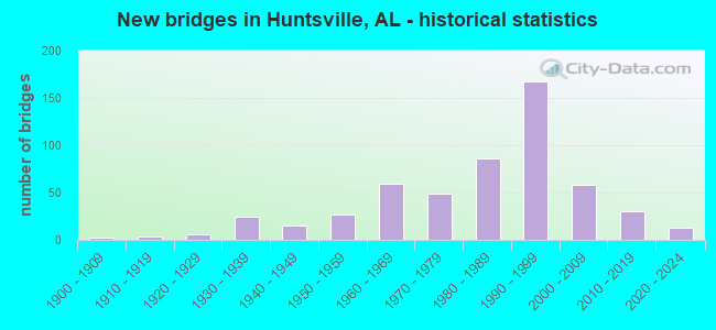
- New bridges - historical statistics
- 21900-1909
- 31910-1919
- 131920-1929
- 381930-1939
- 241940-1949
- 421950-1959
- 711960-1969
- 551970-1979
- 1011980-1989
- 1771990-1999
- 662000-2009
- 352010-2019
- 122020-2022
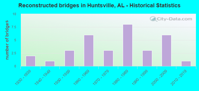
- Reconstructed bridges - Historical Statistics
- 21930-1939
- 11940-1949
- 31950-1959
- 61960-1969
- 31970-1979
- 81980-1989
- 31990-1999
- 62000-2009
- 12010-2019
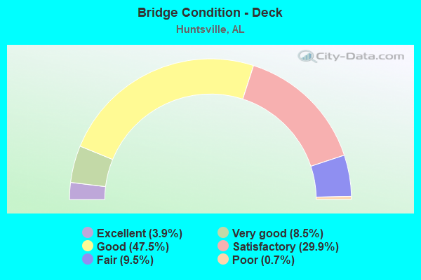
- Bridge Condition - Deck
- 3.9%Excellent
- 8.5%Very good
- 47.5%Good
- 29.9%Satisfactory
- 9.5%Fair
- 0.7%Poor
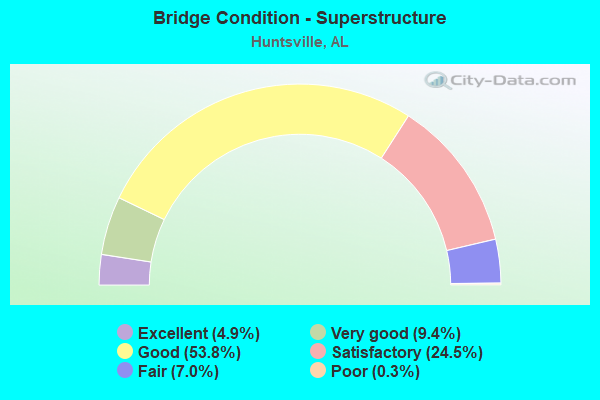
- Bridge Condition - Superstructure
- 4.9%Excellent
- 9.4%Very good
- 53.8%Good
- 24.5%Satisfactory
- 7.0%Fair
- 0.3%Poor
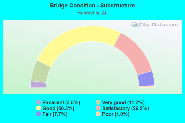
- Bridge Condition - Substructure
- 3.5%Excellent
- 11.2%Very good
- 50.3%Good
- 26.2%Satisfactory
- 7.7%Fair
- 1.0%Poor
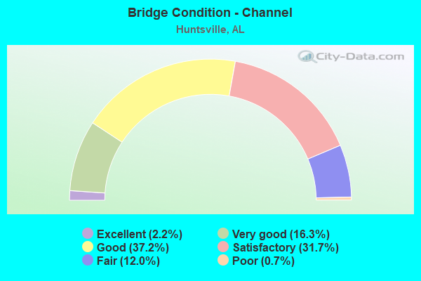
- Bridge Condition - Channel
- 2.2%Excellent
- 16.3%Very good
- 37.2%Good
- 31.7%Satisfactory
- 12.0%Fair
- 0.7%Poor
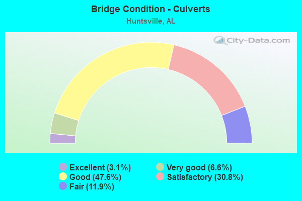
- Bridge Condition - Culverts
- 3.1%Excellent
- 6.6%Very good
- 47.6%Good
- 30.8%Satisfactory
- 11.9%Fair
Find on map >> Show street view
Structure Number: 9808, Location: 0.3 MI N JCT I-565*SR255 (Lat: 34.713250, Lng: -86.671056), Route carried "on" structure: City street , Year Built: 1968, Status: Closed, Structure Length: 7.01m (23.00ft), Average Daily Traffic: 23,000 (year 2019), Truck Traffic: 4%, Average Future Daily Traffic: 32,200 (year 2039), Design Load: HS 20, Features Intersected: SR 255, Facility Carried by Structure: MADISON PIKE
Minimum Vertical Clearance: 30+ m (98+ ft), Kilometerpoint: 0.010, Lanes on structure: 5, Lanes under structure: 6, Owner: State Highway Agency, Approaching Roadway Width: 20.7m (67.9ft), Material/Design: Concrete continuous, Design/Construction: Tee Beam, Number Of Spans In Main Unit: 4, Length of Maximum Span: 19.2m (63.0ft), Curb or Sidewalk Widths: Left: 0.5m (1.6ft), Right: 0.5m (1.6ft), Curb-To-Curb Width: 15.8m (51.8ft), Out-to-Out Width: 17.4m (57.1ft)
Condition: Deck: Good, Superstructure: Good, Substructure: Very good, Operating Rating: 41.4 metric tons, Method Used To Determine Operating Rating: Load Factor (LF), Inventory Rating: 24.8 metric tons, Method Used To Determine Inventory Rating: Load Factor (LF), Structural Evaluation: Equal to present minimum criteria, Underclear: Meets minimum limits, Approach Roadway Alignment: Better than present minimum criteria, Length Of Structure Improvement: 8.04m (26.38ft), Designated Inspection Frequency: Every 24 months, Inspection Date: October 2020, Bridge Improvement Cost: $3,144,000, Roadway Improvement Cost: $314,000, Total Project Cost: $3,458,000 ( Estimate for 2022), Deck Structure Type: Concrete Cast-file-Place
Find on map >> Show street view
Structure Number: 9809, Location: 1.1 MI N JCT I-565 (Lat: 34.723208, Lng: -86.670419), Route carried "on" structure: State highway 255, Year Built: 1968, Status: Open, Structure Length: 1.52m (4.99ft), Average Daily Traffic: 63,192 (year 2018), Truck Traffic: 4%, Average Future Daily Traffic: 88,469 (year 2038), Design Load: H 20, Features Intersected: BRANCH
Minimum Vertical Clearance: 30+ m (98+ ft), Kilometerpoint: 2.477, Lanes on structure: 5, Base Highway Network: Yes, Owner: State Highway Agency, Approaching Roadway Width: 18.3m (60.0ft), Skew: 20 degrees, Material/Design: Concrete, Design/Construction: Culvert, Number Of Spans In Main Unit: 4, Length of Maximum Span: 3.7m (12.1ft)
Condition: Channel: Very good, Culverts: Good, Operating Rating: 88.9 metric tons, Method Used To Determine Operating Rating: Load Factor (LF), Inventory Rating: 65.8 metric tons, Method Used To Determine Inventory Rating: Load Factor (LF), Structural Evaluation: Better than present minimum criteria, Waterway Adequacy: Equal to present minimum criteria, Approach Roadway Alignment: Equal to present desirable criteria, Length Of Structure Improvement: 2.20m (7.22ft), Designated Inspection Frequency: Every 24 months, Inspection Date: July 2020, Bridge Improvement Cost: $1,855,000, Roadway Improvement Cost: $186,000, Total Project Cost: $2,041,000 ( Estimate for 2022), Wearing Surface/Protective System: Wearing Surface: Bituminous
Find on map >> Show street view
Structure Number: 981, Location: 2 MI N JCT I-565 (Lat: 34.735597, Lng: -86.670147), Route carried "on" structure: State highway 255, Year Built: 1968, Status: Open, Structure Length: 1.52m (4.99ft), Average Daily Traffic: 62,252 (year 2018), Truck Traffic: 4%, Average Future Daily Traffic: 87,153 (year 2038), Design Load: H 20, Features Intersected: BRANCH
Minimum Vertical Clearance: 30+ m (98+ ft), Kilometerpoint: 4.059, Lanes on structure: 5, Owner: State Highway Agency, Approaching Roadway Width: 18.3m (60.0ft), Skew: 10 degrees, Material/Design: Concrete, Design/Construction: Culvert, Number Of Spans In Main Unit: 4, Length of Maximum Span: 3.7m (12.1ft)
Condition: Channel: Satisfactory, Culverts: Good, Operating Rating: 88.9 metric tons, Method Used To Determine Operating Rating: Load Factor (LF), Inventory Rating: 55.3 metric tons, Method Used To Determine Inventory Rating: Load Factor (LF), Structural Evaluation: Better than present minimum criteria, Waterway Adequacy: Equal to present desirable criteria, Approach Roadway Alignment: Equal to present desirable criteria, Length Of Structure Improvement: 2.20m (7.22ft), Designated Inspection Frequency: Every 24 months, Inspection Date: June 2020, Bridge Improvement Cost: $1,804,000, Roadway Improvement Cost: $180,000, Total Project Cost: $1,984,000 ( Estimate for 2022), Deck Structure Type: Concrete Cast-file-Place, Wearing Surface/Protective System: Wearing Surface: Bituminous
Find on map >> Show street view
Structure Number: 9811, Location: JCT US 72 * SR 255 (Lat: 34.741672, Lng: -86.670158), Route carried "on" structure: State highway 255, Year Built: 1968, Status: Open, Structure Length: 8.63m (28.31ft), Average Daily Traffic: 30,888 (year 2019), Truck Traffic: 4%, Average Future Daily Traffic: 43,243 (year 2039), Design Load: HS 20, Features Intersected: US 72; SR 2
Minimum Vertical Clearance: 30+ m (98+ ft), Kilometerpoint: 4.703, Lanes on structure: 3, Lanes under structure: 8, Owner: State Highway Agency, Approaching Roadway Width: 14.6m (47.9ft), Skew: 11 degrees, Material/Design: Concrete continuous, Design/Construction: Tee Beam, Number Of Spans In Main Unit: 4, Length of Maximum Span: 23.8m (78.1ft), Curb or Sidewalk Widths: Left: 0.5m (1.6ft), Right: 0.5m (1.6ft), Curb-To-Curb Width: 12.2m (40.0ft), Out-to-Out Width: 13.8m (45.3ft)
Condition: Deck: Satisfactory, Superstructure: Satisfactory, Substructure: Good, Operating Rating: 36.7 metric tons, Method Used To Determine Operating Rating: Load Factor (LF), Inventory Rating: 22.0 metric tons, Method Used To Determine Inventory Rating: Load Factor (LF), Structural Evaluation: Somewhat better than minimum adequacy, Deck Geometry: High priority of corrective action, Underclear: High priority of corrective action, Approach Roadway Alignment: Better than present minimum criteria, Length Of Structure Improvement: 9.61m (31.53ft), Designated Inspection Frequency: Every 24 months, Inspection Date: October 2020, Bridge Improvement Cost: $2,966,000, Roadway Improvement Cost: $297,000, Total Project Cost: $3,263,000 ( Estimate for 2022), Deck Structure Type: Concrete Cast-file-Place
Find on map >> Show street view
Structure Number: 9812, Location: JCT US 72 * SR 255 (Lat: 34.741644, Lng: -86.669881), Route carried "on" structure: State highway 255, Year Built: 1968, Status: Open, Structure Length: 8.63m (28.31ft), Average Daily Traffic: 30,888 (year 2019), Truck Traffic: 4%, Average Future Daily Traffic: 43,243 (year 2039), Design Load: HS 20, Features Intersected: US 72; SR 2
Minimum Vertical Clearance: 30+ m (98+ ft), Kilometerpoint: 4.703, Lanes on structure: 3, Lanes under structure: 8, Owner: State Highway Agency, Approaching Roadway Width: 14.6m (47.9ft), Skew: 11 degrees, Material/Design: Concrete continuous, Design/Construction: Tee Beam, Number Of Spans In Main Unit: 4, Length of Maximum Span: 23.8m (78.1ft), Curb or Sidewalk Widths: Left: 0.5m (1.6ft), Right: 0.5m (1.6ft), Curb-To-Curb Width: 12.2m (40.0ft), Out-to-Out Width: 13.8m (45.3ft)
Condition: Deck: Satisfactory, Superstructure: Satisfactory, Substructure: Good, Operating Rating: 36.7 metric tons, Method Used To Determine Operating Rating: Load Factor (LF), Inventory Rating: 22.0 metric tons, Method Used To Determine Inventory Rating: Load Factor (LF), Structural Evaluation: Somewhat better than minimum adequacy, Deck Geometry: High priority of corrective action, Underclear: High priority of corrective action, Approach Roadway Alignment: Equal to present desirable criteria, Length Of Structure Improvement: 9.61m (31.53ft), Designated Inspection Frequency: Every 24 months, Inspection Date: October 2020, Bridge Improvement Cost: $2,966,000, Roadway Improvement Cost: $297,000, Total Project Cost: $3,263,000 ( Estimate for 2022), Deck Structure Type: Concrete Cast-file-Place
Find on map >> Show street view
Structure Number: 9845, Location: 1.3 MI N JCT US 72 (Lat: 34.752572, Lng: -86.636817), Route carried "on" structure: State highway 53, Year Built: 1957, Year Reconstructed: 1969, Status: Open, Structure Length: 1.58m (5.18ft), Average Daily Traffic: 28,742 (year 2018), Truck Traffic: 4%, Average Future Daily Traffic: 40,238 (year 2038), Design Load: HS 20, Features Intersected: BROGLAN BRANCH
Minimum Vertical Clearance: 30+ m (98+ ft), Kilometerpoint: 517.018, Lanes on structure: 5, Base Highway Network: Yes, Owner: State Highway Agency, Approaching Roadway Width: 18.3m (60.0ft), Skew: 4 degrees, Material/Design: Concrete, Design/Construction: Culvert, Number Of Spans In Main Unit: 3, Length of Maximum Span: 3.7m (12.1ft)
Condition: Channel: Satisfactory, Culverts: Fair, Operating Rating: 79.7 metric tons, Method Used To Determine Operating Rating: Load Factor (LF), Inventory Rating: 47.8 metric tons, Method Used To Determine Inventory Rating: Load Factor (LF), Structural Evaluation: Somewhat better than minimum adequacy, Waterway Adequacy: Better than present minimum criteria, Approach Roadway Alignment: Better than present minimum criteria, Length Of Structure Improvement: 2.26m (7.41ft), Designated Inspection Frequency: Every 24 months, Inspection Date: July 2020, Bridge Improvement Cost: $940,000, Roadway Improvement Cost: $94,000, Total Project Cost: $1,034,000 ( Estimate for 2022), Wearing Surface/Protective System: Wearing Surface: Bituminous
Find on map >> Show street view
Structure Number: 9975, Location: WYNN DR S OF HOLMES AVE (Lat: 34.731667, Lng: -86.655000), Route carried "on" structure: City street , Year Built: 1969, Status: Open, Structure Length: 1.31m (4.30ft), Average Daily Traffic: 15,100 (year 2017), Truck Traffic: 2%, Average Future Daily Traffic: 21,140 (year 2037), Design Load: H 15, Features Intersected: MCDONALD CREEK, Facility Carried by Structure: WYNN DR
Minimum Vertical Clearance: 30+ m (98+ ft), Kilometerpoint: 0.010, Lanes on structure: 4, Owner: City or Municipal Highway Agency, Approaching Roadway Width: 19.2m (63.0ft), Skew: 3 degrees, Material/Design: Concrete, Design/Construction: Culvert, Number Of Spans In Main Unit: 4, Length of Maximum Span: 3.0m (9.8ft)
Condition: Channel: Good, Culverts: Fair, Operating Rating: 61.8 metric tons, Method Used To Determine Operating Rating: Load Factor (LF), Inventory Rating: 37.1 metric tons, Method Used To Determine Inventory Rating: Load Factor (LF), Structural Evaluation: Somewhat better than minimum adequacy, Waterway Adequacy: Better than present minimum criteria, Approach Roadway Alignment: Better than present minimum criteria, Length Of Structure Improvement: 1.98m (6.50ft), Designated Inspection Frequency: Every 24 months, Inspection Date: June 2020, Bridge Improvement Cost: $1,169,000, Roadway Improvement Cost: $117,000, Total Project Cost: $1,286,000 ( Estimate for 2022)
Find on map >> Show street view
Structure Number: 10056, Location: USELESS DRAKE (Lat: 34.697714, Lng: -86.584478), Route carried "on" structure: US 231, Year Built: 1969, Status: Open, Structure Length: 8.72m (28.61ft), Average Daily Traffic: 94,385 (year 2019), Truck Traffic: 3%, Average Future Daily Traffic: 132,139 (year 2039), Design Load: HS 20, Features Intersected: SERVICE ROAD LOOP
Minimum Vertical Clearance: 30+ m (98+ ft), Kilometerpoint: 507.449, Lanes on structure: 6, Lanes under structure: 2, Base Highway Network: Yes, Owner: State Highway Agency, Approaching Roadway Width: 26.8m (87.9ft), Skew: 30 degrees, Material/Design: Steel, Design/Construction: Stringer/Multi-beam, Number Of Spans In Main Unit: 4, Length of Maximum Span: 24.7m (81.0ft), Curb or Sidewalk Widths: Left: 0.5m (1.6ft), Right: 0.5m (1.6ft), Curb-To-Curb Width: 24.9m (81.7ft), Out-to-Out Width: 27.2m (89.2ft)
Condition: Deck: Satisfactory, Superstructure: Good, Substructure: Good, Operating Rating: 79.4 metric tons, Method Used To Determine Operating Rating: Load Factor (LF), Inventory Rating: 47.5 metric tons, Method Used To Determine Inventory Rating: Load Factor (LF), Structural Evaluation: Better than present minimum criteria, Deck Geometry: Somewhat better than minimum adequacy, Underclear: Somewhat better than minimum adequacy, Approach Roadway Alignment: Better than present minimum criteria, Length Of Structure Improvement: 9.70m (31.82ft), Designated Inspection Frequency: Every 24 months, Inspection Date: October 2020, Bridge Improvement Cost: $5,921,000, Roadway Improvement Cost: $592,000, Total Project Cost: $6,513,000 ( Estimate for 2022), Deck Structure Type: Concrete Cast-file-Place
Find on map >> Show street view
Structure Number: 10193, Location: 3 M N JCT I 65 & I 565 (Lat: 34.671894, Lng: -86.919733), Route carried "on" structure: Interstate 65, Year Built: 1970, Status: Open, Structure Length: 1.25m (4.10ft), Average Daily Traffic: 25,660 (year 2020), Truck Traffic: 39%, Average Future Daily Traffic: 32,509 (year 2033), Design Load: H 20, Features Intersected: STREAM
Minimum Vertical Clearance: 30+ m (98+ ft), Kilometerpoint: 552.398, Lanes on structure: 4, Base Highway Network: Yes, Owner: State Highway Agency, Approaching Roadway Width: 20.7m (67.9ft), Skew: 11 degrees, Material/Design: Concrete, Design/Construction: Culvert, Number Of Spans In Main Unit: 4, Length of Maximum Span: 3.0m (9.8ft)
Condition: Channel: Good, Culverts: Satisfactory, Operating Rating: 53.6 metric tons, Method Used To Determine Operating Rating: Load Factor (LF), Inventory Rating: 32.1 metric tons, Method Used To Determine Inventory Rating: Load Factor (LF), Structural Evaluation: Equal to present minimum criteria, Waterway Adequacy: Equal to present minimum criteria, Approach Roadway Alignment: Equal to present desirable criteria, Length Of Structure Improvement: 1.92m (6.30ft), Designated Inspection Frequency: Every 24 months, Inspection Date: May 2020, Bridge Improvement Cost: $1,933,000, Roadway Improvement Cost: $193,000, Total Project Cost: $2,126,000 ( Estimate for 2022)
Find on map >> Show street view
Structure Number: 10263, Location: 1 MI W JCT US72 * SR 53 (Lat: 34.735194, Lng: -86.644264), Route carried "on" structure: US 72, Year Built: 1970, Status: Open, Structure Length: 6.25m (20.51ft), Average Daily Traffic: 24,000 (year 2019), Truck Traffic: 4%, Average Future Daily Traffic: 33,600 (year 2039), Design Load: HS 20, Features Intersected: SPARKMAN DRIVE
Minimum Vertical Clearance: 30+ m (98+ ft), Kilometerpoint: 152.033, Lanes on structure: 4, Lanes under structure: 5, Base Highway Network: Yes, Owner: State Highway Agency, Approaching Roadway Width: 13.4m (44.0ft), Skew: 10 degrees, Material/Design: Steel, Design/Construction: Stringer/Multi-beam, Number Of Spans In Main Unit: 1, Number Of Approach Spans: 2, Length of Maximum Span: 33.5m (109.9ft), Curb or Sidewalk Widths: Left: 0.2m (0.7ft), Right: 0.2m (0.7ft), Curb-To-Curb Width: 15.6m (51.2ft), Out-to-Out Width: 16.7m (54.8ft)
Condition: Deck: Good, Superstructure: Good, Substructure: Satisfactory, Operating Rating: 84.0 metric tons, Method Used To Determine Operating Rating: Load Factor (LF), Inventory Rating: 50.3 metric tons, Method Used To Determine Inventory Rating: Load Factor (LF), Structural Evaluation: Equal to present minimum criteria, Deck Geometry: Meets minimum limits, Underclear: High priority of corrective action, Approach Roadway Alignment: Better than present minimum criteria, Length Of Structure Improvement: 7.29m (23.92ft), Designated Inspection Frequency: Every 24 months, Inspection Date: September 2020, Bridge Improvement Cost: $2,700,000, Roadway Improvement Cost: $270,000, Total Project Cost: $2,970,000 ( Estimate for 2022), Deck Structure Type: Concrete Cast-file-Place
Find on map >> Show street view
Structure Number: 10264, Location: 1 MI W JCT US72 * SR 53 (Lat: 34.735017, Lng: -86.644261), Route carried "on" structure: US 72, Year Built: 1970, Status: Open, Structure Length: 6.25m (20.51ft), Average Daily Traffic: 24,000 (year 2019), Truck Traffic: 4%, Average Future Daily Traffic: 33,600 (year 2039), Design Load: HS 20, Features Intersected: SPARKMAN DRIVE
Minimum Vertical Clearance: 30+ m (98+ ft), Kilometerpoint: 152.033, Lanes on structure: 3, Lanes under structure: 5, Base Highway Network: Yes, Owner: State Highway Agency, Approaching Roadway Width: 15.8m (51.8ft), Skew: 10 degrees, Material/Design: Steel, Design/Construction: Stringer/Multi-beam, Number Of Spans In Main Unit: 1, Number Of Approach Spans: 2, Length of Maximum Span: 33.5m (109.9ft), Curb or Sidewalk Widths: Left: 0.2m (0.7ft), Right: 0.2m (0.7ft), Curb-To-Curb Width: 11.9m (39.0ft), Out-to-Out Width: 13.0m (42.7ft)
Condition: Deck: Good, Superstructure: Good, Substructure: Good, Operating Rating: 88.9 metric tons, Method Used To Determine Operating Rating: Load Factor (LF), Inventory Rating: 55.4 metric tons, Method Used To Determine Inventory Rating: Load Factor (LF), Structural Evaluation: Better than present minimum criteria, Deck Geometry: High priority of corrective action, Underclear: High priority of corrective action, Approach Roadway Alignment: Better than present minimum criteria, Length Of Structure Improvement: 7.29m (23.92ft), Designated Inspection Frequency: Every 24 months, Inspection Date: September 2020, Bridge Improvement Cost: $2,100,000, Roadway Improvement Cost: $210,000, Total Project Cost: $2,310,000 ( Estimate for 2022), Deck Structure Type: Concrete Cast-file-Place
Find on map >> Show street view
Structure Number: 10277, Location: Warhawk * OLD MADISON PK (Lat: 34.713333, Lng: -86.656667), Route carried "on" structure: City street , Year Built: 1970, Status: Open, Structure Length: 1.26m (4.13ft), Average Daily Traffic: 750 (year 2019), Truck Traffic: 2%, Average Future Daily Traffic: 1,050 (year 2039), Design Load: H 15, Features Intersected: MCDONALD CREEK, Facility Carried by Structure: WARHAWK WAY
Minimum Vertical Clearance: 30+ m (98+ ft), Kilometerpoint: 0.010, Lanes on structure: 5, Owner: City or Municipal Highway Agency, Approaching Roadway Width: 21.6m (70.9ft), Material/Design: Concrete, Design/Construction: Culvert, Number Of Spans In Main Unit: 4, Length of Maximum Span: 3.0m (9.8ft)
Condition: Channel: Satisfactory, Culverts: Good, Operating Rating: 68.1 metric tons, Method Used To Determine Operating Rating: Load Factor (LF), Inventory Rating: 40.8 metric tons, Method Used To Determine Inventory Rating: Load Factor (LF), Structural Evaluation: Better than present minimum criteria, Waterway Adequacy: Better than present minimum criteria, Approach Roadway Alignment: Better than present minimum criteria, Length Of Structure Improvement: 1.94m (6.36ft), Designated Inspection Frequency: Every 24 months, Inspection Date: September 2020, Bridge Improvement Cost: $1,615,000, Roadway Improvement Cost: $162,000, Total Project Cost: $1,777,000 ( Estimate for 2022)
Find on map >> Show street view
Structure Number: 10325, Location: 2600 ELTON ST (Lat: 34.760000, Lng: -86.641667), Route carried "on" structure: City street , Year Built: 1970, Status: Open, Structure Length: 1.34m (4.40ft), Average Daily Traffic: 1,500 (year 2017), Truck Traffic: 1%, Average Future Daily Traffic: 2,100 (year 2037), Design Load: H 15, Features Intersected: DRY CREEK, Facility Carried by Structure: ELTON ST
Minimum Vertical Clearance: 30+ m (98+ ft), Kilometerpoint: 0.010, Lanes on structure: 2, Owner: City or Municipal Highway Agency, Approaching Roadway Width: 7.9m (25.9ft), Skew: 4 degrees, Material/Design: Concrete, Design/Construction: Culvert, Number Of Spans In Main Unit: 3, Length of Maximum Span: 4.3m (14.1ft)
Condition: Channel: Satisfactory, Culverts: Good, Operating Rating: 52.9 metric tons, Method Used To Determine Operating Rating: Load Factor (LF), Inventory Rating: 31.8 metric tons, Method Used To Determine Inventory Rating: Load Factor (LF), Structural Evaluation: Better than present minimum criteria, Waterway Adequacy: Better than present minimum criteria, Approach Roadway Alignment: Better than present minimum criteria, Length Of Structure Improvement: 2.02m (6.63ft), Designated Inspection Frequency: Every 24 months, Inspection Date: July 2020, Bridge Improvement Cost: $792,000, Roadway Improvement Cost: $79,000, Total Project Cost: $871,000 ( Estimate for 2022)
Find on map >> Show street view
Structure Number: 10345, Location: 2201 OAKWOOD RD (Lat: 34.751667, Lng: -86.635000), Route carried "on" structure: City street , Year Built: 1970, Status: Open, Structure Length: 1.13m (3.71ft), Average Daily Traffic: 2,050 (year 2018), Truck Traffic: 20%, Average Future Daily Traffic: 2,870 (year 2038), Design Load: H 15, Features Intersected: DRY CREEK, Facility Carried by Structure: OAKWOOD RD
Minimum Vertical Clearance: 30+ m (98+ ft), Kilometerpoint: 0.010, Lanes on structure: 2, Owner: City or Municipal Highway Agency, Approaching Roadway Width: 8.2m (26.9ft), Material/Design: Concrete, Design/Construction: Culvert, Number Of Spans In Main Unit: 3, Length of Maximum Span: 3.7m (12.1ft), Curb or Sidewalk Widths: Left: 0.0m, Right: 1.2m (3.9ft)
Condition: Channel: Satisfactory, Culverts: Satisfactory, Operating Rating: 55.5 metric tons, Method Used To Determine Operating Rating: Load Factor (LF), Inventory Rating: 33.3 metric tons, Method Used To Determine Inventory Rating: Load Factor (LF), Structural Evaluation: Equal to present minimum criteria, Waterway Adequacy: Better than present minimum criteria, Approach Roadway Alignment: Better than present minimum criteria, Length Of Structure Improvement: 1.81m (5.94ft), Designated Inspection Frequency: Every 24 months, Inspection Date: July 2020, Bridge Improvement Cost: $500,000, Roadway Improvement Cost: $50,000, Total Project Cost: $550,000 ( Estimate for 2022)
Find on map >> Show street view
Structure Number: 10364, Location: N OF CEDAR POINT SUB DIV (Lat: 34.805347, Lng: -86.625950), Route carried "on" structure: City street , Year Built: 1970, Status: Open, Structure Length: 0.76m (2.49ft), Average Daily Traffic: 8,800 (year 2016), Truck Traffic: 1%, Average Future Daily Traffic: 999,999 (year 2036), Design Load: H 15, Features Intersected: PINHOOK CREEK, Facility Carried by Structure: PULASKI PIKE
Minimum Vertical Clearance: 30+ m (98+ ft), Kilometerpoint: 0.010, Lanes on structure: 4, Owner: City or Municipal Highway Agency, Approaching Roadway Width: 15.8m (51.8ft), Skew: 4 degrees, Material/Design: Concrete, Design/Construction: Culvert, Number Of Spans In Main Unit: 2, Length of Maximum Span: 3.7m (12.1ft)
Condition: Channel: Good, Culverts: Good, Operating Rating: 88.9 metric tons, Method Used To Determine Operating Rating: Load Factor (LF), Inventory Rating: 80.1 metric tons, Method Used To Determine Inventory Rating: Load Factor (LF), Structural Evaluation: Better than present minimum criteria, Waterway Adequacy: Better than present minimum criteria, Approach Roadway Alignment: Better than present minimum criteria, Length Of Structure Improvement: 1.41m (4.63ft), Designated Inspection Frequency: Every 24 months, Inspection Date: March 2020, Bridge Improvement Cost: $1,154,000, Roadway Improvement Cost: $115,000, Total Project Cost: $1,269,000 ( Estimate for 2022)
Find on map >> Show street view
Structure Number: 10386, Location: CENTAUR * MCDONALD CREEK (Lat: 34.688333, Lng: -86.622222), Route carried "on" structure: City street , Year Built: 1970, Status: Open, Structure Length: 2.56m (8.40ft), Average Daily Traffic: 2,200 (year 2015), Truck Traffic: 1%, Average Future Daily Traffic: 3,080 (year 2035), Design Load: H 15, Features Intersected: MCDONALD CREEK, Facility Carried by Structure: CENTAUR
Minimum Vertical Clearance: 30+ m (98+ ft), Kilometerpoint: 0.010, Lanes on structure: 2, Owner: City or Municipal Highway Agency, Approaching Roadway Width: 9.1m (29.9ft), Material/Design: Concrete, Design/Construction: Culvert, Number Of Spans In Main Unit: 5, Length of Maximum Span: 4.9m (16.1ft), Curb or Sidewalk Widths: Left: 1.7m (5.6ft), Right: 0.0m, Curb-To-Curb Width: 9.1m (29.9ft), Out-to-Out Width: 12.2m (40.0ft)
Condition: Channel: Satisfactory, Culverts: Fair, Operating Rating: 49.2 metric tons, Method Used To Determine Operating Rating: Load Factor (LF), Inventory Rating: 29.4 metric tons, Method Used To Determine Inventory Rating: Load Factor (LF), Structural Evaluation: Somewhat better than minimum adequacy, Deck Geometry: Meets minimum limits, Waterway Adequacy: Better than present minimum criteria, Approach Roadway Alignment: Better than present minimum criteria, Length Of Structure Improvement: 3.46m (11.35ft), Designated Inspection Frequency: Every 24 months, Inspection Date: November 2020, Bridge Improvement Cost: $778,000, Roadway Improvement Cost: $78,000, Total Project Cost: $856,000 ( Estimate for 2022)
Find on map >> Show street view
Structure Number: 10396, Location: GARTH * DRAKE (Lat: 34.705000, Lng: -86.555000), Route carried "on" structure: City street , Year Built: 1970, Status: Open, Structure Length: 0.73m (2.40ft), Average Daily Traffic: 1,100 (year 2015), Truck Traffic: 1%, Average Future Daily Traffic: 1,540 (year 2035), Design Load: H 15, Features Intersected: ALDRIDGE CREEK, Facility Carried by Structure: GARTH
Minimum Vertical Clearance: 30+ m (98+ ft), Kilometerpoint: 0.010, Lanes on structure: 2, Owner: City or Municipal Highway Agency, Approaching Roadway Width: 9.1m (29.9ft), Material/Design: Concrete, Design/Construction: Culvert, Number Of Spans In Main Unit: 3, Length of Maximum Span: 2.4m (7.9ft), Curb-To-Curb Width: 18.1m (59.4ft), Out-to-Out Width: 18.6m (61.0ft)
Condition: Channel: Very good, Culverts: Satisfactory, Operating Rating: 43.5 metric tons, Method Used To Determine Operating Rating: Field evaluation and documented engineering judgment, Inventory Rating: 32.7 metric tons, Method Used To Determine Inventory Rating: Field evaluation and documented engineering judgment, Structural Evaluation: Equal to present minimum criteria, Deck Geometry: Superior to present desirable criteria, Waterway Adequacy: Better than present minimum criteria, Approach Roadway Alignment: Better than present minimum criteria, Length Of Structure Improvement: 1.38m (4.53ft), Designated Inspection Frequency: Every 24 months, Inspection Date: April 2020, Bridge Improvement Cost: $485,000, Roadway Improvement Cost: $49,000, Total Project Cost: $534,000 ( Estimate for 2022)
Find on map >> Show street view
Structure Number: 10424, Location: BETWEEN RISON * STEVENS (Lat: 34.745000, Lng: -86.573333), Route carried "on" structure: City street , Year Built: 1970, Status: Open, Structure Length: 1.01m (3.31ft), Average Daily Traffic: 350 (year 2017), Truck Traffic: 1%, Average Future Daily Traffic: 490 (year 2037), Design Load: H 15, Features Intersected: DALLAS CREEK, Facility Carried by Structure: ENGLAND ST
Minimum Vertical Clearance: 30+ m (98+ ft), Kilometerpoint: 0.010, Lanes on structure: 2, Owner: City or Municipal Highway Agency, Approaching Roadway Width: 7.9m (25.9ft), Skew: 1 degrees, Material/Design: Concrete, Design/Construction: Culvert, Number Of Spans In Main Unit: 3, Length of Maximum Span: 3.4m (11.2ft), Curb or Sidewalk Widths: Left: 1.2m (3.9ft), Right: 1.2m (3.9ft), Curb-To-Curb Width: 7.4m (24.3ft), Out-to-Out Width: 10.4m (34.1ft)
Condition: Channel: Very good, Culverts: Good, Operating Rating: 45.4 metric tons, Method Used To Determine Operating Rating: Load Factor (LF), Inventory Rating: 27.2 metric tons, Method Used To Determine Inventory Rating: Load Factor (LF), Structural Evaluation: Equal to present minimum criteria, Deck Geometry: Somewhat better than minimum adequacy, Waterway Adequacy: Better than present minimum criteria, Approach Roadway Alignment: Better than present minimum criteria, Length Of Structure Improvement: 1.68m (5.51ft), Designated Inspection Frequency: Every 24 months, Inspection Date: May 2020, Bridge Improvement Cost: $340,000, Roadway Improvement Cost: $34,000, Total Project Cost: $374,000 ( Estimate for 2022)
Find on map >> Show street view
Structure Number: 10426, Location: WINDHAM * HALSEY (Lat: 34.746667, Lng: -86.568333), Route carried "on" structure: City street , Year Built: 1970, Status: Open, Structure Length: 1.07m (3.51ft), Average Daily Traffic: 500 (year 2017), Truck Traffic: 1%, Average Future Daily Traffic: 700 (year 2037), Design Load: H 15, Features Intersected: DALLAS CREEK, Facility Carried by Structure: WINDHAM
Minimum Vertical Clearance: 30+ m (98+ ft), Kilometerpoint: 0.010, Lanes on structure: 2, Owner: City or Municipal Highway Agency, Approaching Roadway Width: 10.1m (33.1ft), Skew: 4 degrees, Material/Design: Concrete, Design/Construction: Culvert, Number Of Spans In Main Unit: 3, Length of Maximum Span: 3.7m (12.1ft), Curb or Sidewalk Widths: Left: 1.2m (3.9ft), Right: 1.2m (3.9ft), Curb-To-Curb Width: 14.3m (46.9ft), Out-to-Out Width: 16.8m (55.1ft)
Condition: Channel: Good, Culverts: Good, Operating Rating: 43.7 metric tons, Method Used To Determine Operating Rating: Load Factor (LF), Inventory Rating: 26.2 metric tons, Method Used To Determine Inventory Rating: Load Factor (LF), Structural Evaluation: Equal to present minimum criteria, Deck Geometry: Superior to present desirable criteria, Waterway Adequacy: Better than present minimum criteria, Approach Roadway Alignment: Better than present minimum criteria, Length Of Structure Improvement: 1.74m (5.71ft), Designated Inspection Frequency: Every 24 months, Inspection Date: May 2020, Bridge Improvement Cost: $715,000, Roadway Improvement Cost: $72,000, Total Project Cost: $787,000 ( Estimate for 2022)
Find on map >> Show street view
Structure Number: 10429, Location: 1115 DRAKE (Lat: 34.705000, Lng: -86.556667), Route carried "on" structure: City street , Year Built: 1970, Status: Open, Structure Length: 0.73m (2.40ft), Average Daily Traffic: 30 (year 2017), Average Future Daily Traffic: 42 (year 2037), Design Load: H 15, Features Intersected: ALDRIDGE CREEK, Facility Carried by Structure: DRIVEWAY
Minimum Vertical Clearance: 30+ m (98+ ft), Kilometerpoint: 0.010, Lanes on structure: 1, Owner: City or Municipal Highway Agency, Approaching Roadway Width: 5.5m (18.0ft), Material/Design: Concrete, Design/Construction: Culvert, Number Of Spans In Main Unit: 3, Length of Maximum Span: 2.4m (7.9ft), Curb-To-Curb Width: 5.7m (18.7ft), Out-to-Out Width: 6.3m (20.7ft)
Condition: Channel: Good, Culverts: Good, Operating Rating: 32.7 metric tons, Method Used To Determine Operating Rating: Field evaluation and documented engineering judgment, Inventory Rating: 23.6 metric tons, Method Used To Determine Inventory Rating: Field evaluation and documented engineering judgment, Structural Evaluation: Equal to present minimum criteria, Deck Geometry: Meets minimum limits, Waterway Adequacy: Better than present minimum criteria, Approach Roadway Alignment: Better than present minimum criteria, Length Of Structure Improvement: 1.38m (4.53ft), Designated Inspection Frequency: Every 24 months, Inspection Date: May 2020, Bridge Improvement Cost: $159,000, Roadway Improvement Cost: $16,000, Total Project Cost: $175,000 ( Estimate for 2022)
Find on map >> Show street view
Structure Number: 10431, Location: 8228 BAILEY COVE RD (Lat: 34.656667, Lng: -86.523333), Route carried "on" structure: City street , Year Built: 1970, Status: Open, Structure Length: 0.88m (2.89ft), Average Daily Traffic: 19,700 (year 2017), Truck Traffic: 2%, Average Future Daily Traffic: 27,580 (year 2037), Design Load: H 15, Features Intersected: ALDRIDGE CREEK, Facility Carried by Structure: BAILEY COVE RD
Minimum Vertical Clearance: 30+ m (98+ ft), Kilometerpoint: 0.010, Lanes on structure: 4, Owner: City or Municipal Highway Agency, Approaching Roadway Width: 15.8m (51.8ft), Skew: 4 degrees, Material/Design: Concrete, Design/Construction: Culvert, Number Of Spans In Main Unit: 3, Length of Maximum Span: 2.7m (8.9ft), Curb or Sidewalk Widths: Left: 1.2m (3.9ft), Right: 1.2m (3.9ft)
Condition: Channel: Satisfactory, Culverts: Good, Operating Rating: 32.9 metric tons, Method Used To Determine Operating Rating: Load Factor (LF), Inventory Rating: 19.8 metric tons, Method Used To Determine Inventory Rating: Load Factor (LF), Structural Evaluation: Somewhat better than minimum adequacy, Waterway Adequacy: Better than present minimum criteria, Approach Roadway Alignment: Better than present minimum criteria, Length Of Structure Improvement: 1.55m (5.09ft), Designated Inspection Frequency: Every 24 months, Inspection Date: May 2020, Bridge Improvement Cost: $1,009,000, Roadway Improvement Cost: $101,000, Total Project Cost: $1,110,000 ( Estimate for 2022)
Find on map >> Show street view
Structure Number: 10627, Location: RUSSELL * RISON (Lat: 34.746667, Lng: -86.575000), Route carried "on" structure: City street , Year Built: 1971, Status: Open, Structure Length: 1.04m (3.41ft), Average Daily Traffic: 850 (year 2017), Truck Traffic: 1%, Average Future Daily Traffic: 1,190 (year 2037), Design Load: H 15, Features Intersected: DALLAS CREEK, Facility Carried by Structure: RUSSELL
Minimum Vertical Clearance: 30+ m (98+ ft), Kilometerpoint: 0.010, Lanes on structure: 2, Owner: City or Municipal Highway Agency, Approaching Roadway Width: 8.5m (27.9ft), Skew: 4 degrees, Material/Design: Concrete, Design/Construction: Culvert, Number Of Spans In Main Unit: 3, Length of Maximum Span: 3.4m (11.2ft), Curb or Sidewalk Widths: Left: 0.0m, Right: 1.2m (3.9ft), Curb-To-Curb Width: 26.1m (85.6ft), Out-to-Out Width: 27.5m (90.2ft)
Condition: Channel: Good, Culverts: Good, Operating Rating: 59.1 metric tons, Method Used To Determine Operating Rating: Load Factor (LF), Inventory Rating: 35.4 metric tons, Method Used To Determine Inventory Rating: Load Factor (LF), Structural Evaluation: Better than present minimum criteria, Deck Geometry: Superior to present desirable criteria, Waterway Adequacy: Better than present minimum criteria, Approach Roadway Alignment: Equal to present minimum criteria, Length Of Structure Improvement: 1.71m (5.61ft), Designated Inspection Frequency: Every 24 months, Inspection Date: May 2020, Bridge Improvement Cost: $930,000, Roadway Improvement Cost: $93,000, Total Project Cost: $1,023,000 ( Estimate for 2022)
Find on map >> Show street view
Structure Number: 10629, Location: COLEMAN (Lat: 34.745000, Lng: -86.575000), Route carried "on" structure: City street , Year Built: 1971, Status: Open, Structure Length: 1.07m (3.51ft), Average Daily Traffic: 350 (year 2017), Truck Traffic: 1%, Average Future Daily Traffic: 490 (year 2037), Design Load: H 15, Features Intersected: DALLAS CREEK, Facility Carried by Structure: COLEMAN
Minimum Vertical Clearance: 30+ m (98+ ft), Kilometerpoint: 0.010, Lanes on structure: 2, Owner: City or Municipal Highway Agency, Approaching Roadway Width: 7.6m (24.9ft), Skew: 3 degrees, Material/Design: Concrete, Design/Construction: Culvert, Number Of Spans In Main Unit: 3, Length of Maximum Span: 3.4m (11.2ft), Curb or Sidewalk Widths: Left: 1.2m (3.9ft), Right: 1.2m (3.9ft), Curb-To-Curb Width: 8.1m (26.6ft), Out-to-Out Width: 11.3m (37.1ft)
Condition: Channel: Very good, Culverts: Good, Operating Rating: 57.8 metric tons, Method Used To Determine Operating Rating: Load Factor (LF), Inventory Rating: 34.7 metric tons, Method Used To Determine Inventory Rating: Load Factor (LF), Structural Evaluation: Better than present minimum criteria, Deck Geometry: Somewhat better than minimum adequacy, Waterway Adequacy: Better than present minimum criteria, Approach Roadway Alignment: Better than present minimum criteria, Length Of Structure Improvement: 1.74m (5.71ft), Designated Inspection Frequency: Every 24 months, Inspection Date: May 2020, Bridge Improvement Cost: $403,000, Roadway Improvement Cost: $40,000, Total Project Cost: $443,000 ( Estimate for 2022)
Find on map >> Show street view
Structure Number: 10634, Location: 0.1 MI N JCT CO RD 332 (Lat: 34.748819, Lng: -86.482386), Route carried "on" structure: County highway 318, Year Built: 1971, Status: Open, Structure Length: 0.94m (3.08ft), Average Daily Traffic: 350 (year 1992), Truck Traffic: 1%, Average Future Daily Traffic: 353 (year 2042), Design Load: H 15, Features Intersected: LAWLER BRANCH, Facility Carried by Structure: WINDWOOD DR.
Minimum Vertical Clearance: 30+ m (98+ ft), Kilometerpoint: 0.010, Lanes on structure: 2, Owner: County Highway Agency, Approaching Roadway Width: 9.8m (32.2ft), Skew: 1 degrees, Material/Design: Masonry, Design/Construction: Culvert, Number Of Spans In Main Unit: 2, Length of Maximum Span: 4.3m (14.1ft), Curb-To-Curb Width: 12.2m (40.0ft), Out-to-Out Width: 12.7m (41.7ft)
Condition: Channel: Fair, Culverts: Fair, Operating Rating: 32.7 metric tons, Method Used To Determine Operating Rating: Field evaluation and documented engineering judgment, Inventory Rating: 23.6 metric tons, Method Used To Determine Inventory Rating: Field evaluation and documented engineering judgment, Structural Evaluation: Somewhat better than minimum adequacy, Deck Geometry: Superior to present desirable criteria, Waterway Adequacy: Somewhat better than minimum adequacy, Approach Roadway Alignment: Equal to present minimum criteria, Length Of Structure Improvement: 1.61m (5.28ft), Designated Inspection Frequency: Every 24 months, Inspection Date: Febuary 2022, Bridge Improvement Cost: $427,000, Roadway Improvement Cost: $43,000, Total Project Cost: $470,000 ( Estimate for 2022)
Find on map >> Show street view
Structure Number: 10786, Location: 2208 BRAHAN ST (Lat: 34.721667, Lng: -86.600000), Route carried "on" structure: City street , Year Built: 1972, Status: Open, Structure Length: 3.17m (10.40ft), Average Daily Traffic: 1,500 (year 2017), Truck Traffic: 1%, Average Future Daily Traffic: 2,100 (year 2037), Design Load: H 15, Features Intersected: BROGLAN BRANCH, Facility Carried by Structure: BRAHAN ST
Minimum Vertical Clearance: 30+ m (98+ ft), Kilometerpoint: 0.010, Lanes on structure: 2, Owner: City or Municipal Highway Agency, Approaching Roadway Width: 7.3m (24.0ft), Skew: 3 degrees, Material/Design: Concrete, Design/Construction: Culvert, Number Of Spans In Main Unit: 5, Length of Maximum Span: 6.1m (20.0ft), Curb or Sidewalk Widths: Left: 1.4m (4.6ft), Right: 1.4m (4.6ft), Curb-To-Curb Width: 9.1m (29.9ft), Out-to-Out Width: 12.7m (41.7ft)
Condition: Channel: Very good, Culverts: Good, Operating Rating: 55.2 metric tons, Method Used To Determine Operating Rating: Load Factor (LF), Inventory Rating: 33.1 metric tons, Method Used To Determine Inventory Rating: Load Factor (LF), Structural Evaluation: Better than present minimum criteria, Deck Geometry: Somewhat better than minimum adequacy, Waterway Adequacy: Better than present minimum criteria, Approach Roadway Alignment: Better than present minimum criteria, Length Of Structure Improvement: 4.03m (13.22ft), Designated Inspection Frequency: Every 24 months, Inspection Date: July 2020, Bridge Improvement Cost: $1,187,000, Roadway Improvement Cost: $119,000, Total Project Cost: $1,306,000 ( Estimate for 2022)
Find on map >> Show street view
Structure Number: 10788, Location: 2418 HALL ST (Lat: 34.724147, Lng: -86.603089), Route carried "on" structure: City street , Year Built: 1972, Status: Open, Structure Length: 2.65m (8.69ft), Average Daily Traffic: 3,658 (year 2017), Truck Traffic: 1%, Average Future Daily Traffic: 5,121 (year 2037), Design Load: HS 20, Features Intersected: BROGLAN BRANCH, Facility Carried by Structure: HALL ST
Minimum Vertical Clearance: 30+ m (98+ ft), Kilometerpoint: 0.010, Lanes on structure: 2, Owner: City or Municipal Highway Agency, Approaching Roadway Width: 6.7m (22.0ft), Skew: 3 degrees, Material/Design: Concrete, Design/Construction: Culvert, Number Of Spans In Main Unit: 5, Length of Maximum Span: 5.2m (17.1ft), Curb or Sidewalk Widths: Left: 0.9m (3.0ft), Right: 1.5m (4.9ft), Curb-To-Curb Width: 6.8m (22.3ft), Out-to-Out Width: 14.8m (48.6ft)
Condition: Channel: Good, Culverts: Good, Operating Rating: 53.3 metric tons, Method Used To Determine Operating Rating: Load Factor (LF), Inventory Rating: 31.9 metric tons, Method Used To Determine Inventory Rating: Load Factor (LF), Structural Evaluation: Better than present minimum criteria, Deck Geometry: High priority of replacement, Waterway Adequacy: Better than present minimum criteria, Approach Roadway Alignment: Better than present minimum criteria, Length Of Structure Improvement: 3.56m (11.68ft), Designated Inspection Frequency: Every 24 months, Inspection Date: August 2020, Bridge Improvement Cost: $1,089,000, Roadway Improvement Cost: $109,000, Total Project Cost: $1,198,000 ( Estimate for 2022)
Find on map >> Show street view
Structure Number: 1079, Location: 212 SEMINOLE DR (Lat: 34.721667, Lng: -86.598333), Route carried "on" structure: City street , Year Built: 1972, Status: Open, Structure Length: 2.83m (9.28ft), Average Daily Traffic: 2,660 (year 2017), Truck Traffic: 1%, Average Future Daily Traffic: 3,729 (year 2037), Design Load: H 15, Features Intersected: BROGLAN BRANCH, Facility Carried by Structure: SEMINOLE DR
Minimum Vertical Clearance: 7.56m (24.80ft), Kilometerpoint: 0.010, Lanes on structure: 2, Owner: City or Municipal Highway Agency, Approaching Roadway Width: 12.2m (40.0ft), Skew: 3 degrees, Material/Design: Concrete, Design/Construction: Culvert, Number Of Spans In Main Unit: 5, Length of Maximum Span: 5.5m (18.0ft), Curb or Sidewalk Widths: Left: 0.0m, Right: 1.5m (4.9ft), Curb-To-Curb Width: 12.2m (40.0ft), Out-to-Out Width: 32.3m (106.0ft)
Condition: Channel: Good, Culverts: Good, Operating Rating: 62.8 metric tons, Method Used To Determine Operating Rating: Load Factor (LF), Inventory Rating: 37.6 metric tons, Method Used To Determine Inventory Rating: Load Factor (LF), Structural Evaluation: Better than present minimum criteria, Deck Geometry: Equal to present minimum criteria, Waterway Adequacy: Better than present minimum criteria, Approach Roadway Alignment: Better than present minimum criteria, Length Of Structure Improvement: 3.75m (12.30ft), Designated Inspection Frequency: Every 24 months, Inspection Date: August 2020, Bridge Improvement Cost: $2,576,000, Roadway Improvement Cost: $258,000, Total Project Cost: $2,834,000 ( Estimate for 2022)
Find on map >> Show street view
Structure Number: 10816, Location: BEHIND SCIENCE BLDG (Lat: 34.785336, Lng: -86.576836), Route carried "on" structure: City street , Year Built: 1974, Status: Open, Structure Length: 1.04m (3.41ft), Average Daily Traffic: 11 (year 2017), Average Future Daily Traffic: 15 (year 2037), Design Load: H 15, Features Intersected: BRANCH, Facility Carried by Structure: A*M FIELD RD
Minimum Vertical Clearance: 30+ m (98+ ft), Kilometerpoint: 0.010, Lanes on structure: 2, Owner: City or Municipal Highway Agency, Approaching Roadway Width: 5.2m (17.1ft), Material/Design: Concrete, Design/Construction: Channel Beam, Number Of Spans In Main Unit: 1, Length of Maximum Span: 10.4m (34.1ft), Curb-To-Curb Width: 7.6m (24.9ft), Out-to-Out Width: 8.2m (26.9ft)
Condition: Deck: Good, Superstructure: Satisfactory, Substructure: Good, Channel: Satisfactory, Operating Rating: 51.5 metric tons, Method Used To Determine Operating Rating: Load Factor (LF), Inventory Rating: 30.8 metric tons, Method Used To Determine Inventory Rating: Load Factor (LF), Structural Evaluation: Equal to present minimum criteria, Deck Geometry: High priority of replacement, Waterway Adequacy: Better than present minimum criteria, Approach Roadway Alignment: Better than present minimum criteria, Length Of Structure Improvement: 1.71m (5.61ft), Designated Inspection Frequency: Every 24 months, Inspection Date: December 2020, Bridge Improvement Cost: $305,000, Roadway Improvement Cost: $31,000, Total Project Cost: $336,000 ( Estimate for 2022), Deck Structure Type: Concrete Precast Panels, Wearing Surface/Protective System: Wearing Surface: Gravel
Find on map >> Show street view
Structure Number: 1082, Location: 3 MI NE OF ONEONTA (Lat: 33.995500, Lng: -86.439800), Route carried "on" structure: County highway 273, Year Built: 1972, Status: Posted for load, Structure Length: 1.46m (4.79ft), Average Daily Traffic: 143 (year 2021), Truck Traffic: 1%, Average Future Daily Traffic: 212 (year 2041), Features Intersected: LITTLE WARRIOR, Facility Carried by Structure: COVERED BRIDGE CI
Minimum Vertical Clearance: 30+ m (98+ ft), Kilometerpoint: 0.010, Lanes on structure: 1, Owner: County Highway Agency, Approaching Roadway Width: 3.6m (11.8ft), Material/Design: Steel, Design/Construction: Stringer/Multi-beam, Number Of Spans In Main Unit: 1, Length of Maximum Span: 14.6m (47.9ft), Curb-To-Curb Width: 3.7m (12.1ft), Out-to-Out Width: 4.1m (13.5ft)
Condition: Deck: Good, Superstructure: Fair, Substructure: Fair, Channel: Fair, Operating Rating: 7.7 metric tons, Method Used To Determine Operating Rating: Load Factor (LF), Inventory Rating: 4.6 metric tons, Method Used To Determine Inventory Rating: Load Factor (LF), Structural Evaluation: High priority of replacement, Deck Geometry: High priority of replacement, Waterway Adequacy: Meets minimum limits, Approach Roadway Alignment: Somewhat better than minimum adequacy, Bridge Posting: Required (Relationship of Operating Rating to Maximum Legal Load: > 39.9% below), Length Of Structure Improvement: 2.14m (7.02ft), Designated Inspection Frequency: Every 24 months, Other Special Inspection Frequency: Every 12 months, Inspection Date: January 2021, Other Special Inspection Date: January 2022, Bridge Improvement Cost: $191,000, Roadway Improvement Cost: $19,000, Total Project Cost: $210,000 ( Estimate for 2022), Deck Structure Type: Concrete Cast-file-Place
Find on map >> Show street view
Structure Number: 1083, Location: MT. PISGAH RD. (Lat: 34.122850, Lng: -85.946861), Route carried "on" structure: County highway 315, Year Built: 2003, Status: Open, Structure Length: 0.67m (2.20ft), Average Daily Traffic: 90 (year 2003), Average Future Daily Traffic: 100 (year 2034), Features Intersected: TRIB. TO BLACK CREEK, Facility Carried by Structure: MT. PISGAH RD.
Minimum Vertical Clearance: 30+ m (98+ ft), Kilometerpoint: 0.010, Lanes on structure: 1, Owner: County Highway Agency, Approaching Roadway Width: 6.4m (21.0ft), Material/Design: Steel continuous, Design/Construction: Stringer/Multi-beam, Number Of Spans In Main Unit: 2, Length of Maximum Span: 3.4m (11.2ft), Curb-To-Curb Width: 6.4m (21.0ft), Out-to-Out Width: 6.8m (22.3ft)
Condition: Deck: Good, Superstructure: Good, Substructure: Satisfactory, Channel: Satisfactory, Operating Rating: 80.5 metric tons, Method Used To Determine Operating Rating: Load Factor (LF), Inventory Rating: 48.2 metric tons, Method Used To Determine Inventory Rating: Load Factor (LF), Structural Evaluation: Equal to present minimum criteria, Deck Geometry: Somewhat better than minimum adequacy, Waterway Adequacy: Somewhat better than minimum adequacy, Approach Roadway Alignment: Somewhat better than minimum adequacy, Length Of Structure Improvement: 1.30m (4.27ft), Designated Inspection Frequency: Every 24 months, Inspection Date: May 2020, Bridge Improvement Cost: $196,000, Roadway Improvement Cost: $20,000, Total Project Cost: $216,000 ( Estimate for 2022), Deck Structure Type: Corrugated Steel, Wearing Surface/Protective System: Wearing Surface: Bituminous
Find on map >> Show street view
Structure Number: 10917, Location: 0.3 MI W FLINT RIVER (Lat: 34.743769, Lng: -86.446450), Route carried "on" structure: US 72, Year Built: 1973, Status: Open, Structure Length: 9.33m (30.61ft), Average Daily Traffic: 11,299 (year 2018), Truck Traffic: 8%, Average Future Daily Traffic: 15,818 (year 2038), Design Load: HS 20, Features Intersected: FLINT RIVER RELIEF
Minimum Vertical Clearance: 30+ m (98+ ft), Kilometerpoint: 173.600, Lanes on structure: 2, Base Highway Network: Yes, Owner: State Highway Agency, Approaching Roadway Width: 12.2m (40.0ft), Skew: 10 degrees, Material/Design: Concrete, Design/Construction: Tee Beam, Number Of Spans In Main Unit: 9, Length of Maximum Span: 10.4m (34.1ft), Curb or Sidewalk Widths: Left: 0.2m (0.7ft), Right: 0.2m (0.7ft), Curb-To-Curb Width: 11.6m (38.1ft), Out-to-Out Width: 13.1m (43.0ft)
Condition: Deck: Good, Superstructure: Satisfactory, Substructure: Satisfactory, Channel: Good, Operating Rating: 45.1 metric tons, Method Used To Determine Operating Rating: Load Factor (LF), Inventory Rating: 27.0 metric tons, Method Used To Determine Inventory Rating: Load Factor (LF), Structural Evaluation: Equal to present minimum criteria, Deck Geometry: Somewhat better than minimum adequacy, Waterway Adequacy: Equal to present desirable criteria, Approach Roadway Alignment: Better than present minimum criteria, Length Of Structure Improvement: 10.29m (33.76ft), Designated Inspection Frequency: Every 24 months, Inspection Date: September 2020, Bridge Improvement Cost: $3,033,000, Roadway Improvement Cost: $303,000, Total Project Cost: $3,336,000 ( Estimate for 2022), Deck Structure Type: Concrete Cast-file-Place
Find on map >> Show street view
Structure Number: 10918, Location: 0.2 MI W FLINT RIVER (Lat: 34.742831, Lng: -86.444647), Route carried "on" structure: US 72, Year Built: 1973, Status: Open, Structure Length: 10.36m (33.99ft), Average Daily Traffic: 9,738 (year 2019), Truck Traffic: 8%, Average Future Daily Traffic: 13,633 (year 2039), Design Load: HS 20, Features Intersected: FLINT RIVER RELIEF
Minimum Vertical Clearance: 30+ m (98+ ft), Kilometerpoint: 173.791, Lanes on structure: 2, Base Highway Network: Yes, Owner: State Highway Agency, Approaching Roadway Width: 12.2m (40.0ft), Skew: 10 degrees, Material/Design: Concrete, Design/Construction: Tee Beam, Number Of Spans In Main Unit: 10, Length of Maximum Span: 10.4m (34.1ft), Curb or Sidewalk Widths: Left: 0.2m (0.7ft), Right: 0.2m (0.7ft), Curb-To-Curb Width: 11.6m (38.1ft), Out-to-Out Width: 13.1m (43.0ft)
Condition: Deck: Good, Superstructure: Good, Substructure: Good, Channel: Very good, Operating Rating: 42.5 metric tons, Method Used To Determine Operating Rating: Load Factor (LF), Inventory Rating: 25.5 metric tons, Method Used To Determine Inventory Rating: Load Factor (LF), Structural Evaluation: Equal to present minimum criteria, Deck Geometry: Somewhat better than minimum adequacy, Waterway Adequacy: Equal to present desirable criteria, Approach Roadway Alignment: Equal to present desirable criteria, Length Of Structure Improvement: 11.28m (37.01ft), Designated Inspection Frequency: Every 24 months, Inspection Date: September 2020, Bridge Improvement Cost: $3,325,000, Roadway Improvement Cost: $333,000, Total Project Cost: $3,658,000 ( Estimate for 2022), Deck Structure Type: Concrete Cast-file-Place
Find on map >> Show street view
Structure Number: 10919, Location: INT US72 * FLINT RIVER (Lat: 34.740906, Lng: -86.441050), Route carried "on" structure: US 72, Year Built: 1973, Status: Open, Structure Length: 25.02m (82.09ft), Average Daily Traffic: 9,637 (year 2018), Truck Traffic: 4%, Average Future Daily Traffic: 13,491 (year 2038), Design Load: HS 20, Features Intersected: FLINT RIVER
Minimum Vertical Clearance: 30+ m (98+ ft), Kilometerpoint: 174.017, Lanes on structure: 2, Owner: State Highway Agency, Approaching Roadway Width: 12.2m (40.0ft), Skew: 10 degrees, Material/Design: Steel continuous, Design/Construction: Stringer/Multi-beam, Number Of Spans In Main Unit: 3, Number Of Approach Spans: 17, Length of Maximum Span: 30.5m (100.1ft), Curb or Sidewalk Widths: Left: 0.2m (0.7ft), Right: 0.2m (0.7ft), Curb-To-Curb Width: 12.0m (39.4ft), Out-to-Out Width: 13.1m (43.0ft)
Condition: Deck: Satisfactory, Superstructure: Satisfactory, Substructure: Satisfactory, Channel: Good, Operating Rating: 42.0 metric tons, Method Used To Determine Operating Rating: Load Factor (LF), Inventory Rating: 25.2 metric tons, Method Used To Determine Inventory Rating: Load Factor (LF), Structural Evaluation: Equal to present minimum criteria, Deck Geometry: Better than present minimum criteria, Waterway Adequacy: Equal to present desirable criteria, Approach Roadway Alignment: Better than present minimum criteria, Length Of Structure Improvement: 25.02m (82.09ft), Designated Inspection Frequency: Every 24 months, Inspection Date: September 2020, Bridge Improvement Cost: $7,377,000, Roadway Improvement Cost: $738,000, Total Project Cost: $8,115,000 ( Estimate for 2022), Deck Structure Type: Concrete Cast-file-Place
Find on map >> Show street view
Structure Number: 10978, Location: DRAKE AVE / * SR 53 (Lat: 34.706667, Lng: -86.590000), Route carried "on" structure: US 231, Year Built: 1973, Status: Open, Structure Length: 12.50m (41.01ft), Average Daily Traffic: 102,157 (year 2019), Truck Traffic: 3%, Average Future Daily Traffic: 143,020 (year 2039), Design Load: HS 20, Features Intersected: DRAKE AVE
Minimum Vertical Clearance: 30+ m (98+ ft), Kilometerpoint: 508.269, Lanes on structure: 6, Lanes under structure: 6, Base Highway Network: Yes, Owner: State Highway Agency, Approaching Roadway Width: 12.8m (42.0ft), Skew: 32 degrees, Material/Design: Steel, Design/Construction: Stringer/Multi-beam, Number Of Spans In Main Unit: 3, Number Of Approach Spans: 2, Length of Maximum Span: 29.0m (95.1ft), Curb or Sidewalk Widths: Left: 0.2m (0.7ft), Right: 0.2m (0.7ft), Curb-To-Curb Width: 25.5m (83.7ft), Out-to-Out Width: 27.8m (91.2ft)
Condition: Deck: Satisfactory, Superstructure: Satisfactory, Substructure: Satisfactory, Operating Rating: 55.5 metric tons, Method Used To Determine Operating Rating: Load Factor (LF), Inventory Rating: 33.3 metric tons, Method Used To Determine Inventory Rating: Load Factor (LF), Structural Evaluation: Equal to present minimum criteria, Deck Geometry: Somewhat better than minimum adequacy, Underclear: High priority of replacement, Approach Roadway Alignment: Better than present minimum criteria, Length Of Structure Improvement: 13.34m (43.77ft), Designated Inspection Frequency: Every 24 months, Inspection Date: October 2020, Bridge Improvement Cost: $8,322,000, Roadway Improvement Cost: $832,000, Total Project Cost: $9,154,000 ( Estimate for 2022), Deck Structure Type: Concrete Cast-file-Place
Find on map >> Show street view
Structure Number: 11, Location: TEL FAIR * FAGAN (Lat: 34.731667, Lng: -86.560000), Route carried "on" structure: City street , Year Built: 1973, Status: Open, Structure Length: 0.94m (3.08ft), Average Daily Traffic: 500 (year 2017), Truck Traffic: 1%, Average Future Daily Traffic: 700 (year 2037), Design Load: H 15, Features Intersected: FAGAN CREEK, Facility Carried by Structure: TEL FAIR
Minimum Vertical Clearance: 30+ m (98+ ft), Kilometerpoint: 0.010, Lanes on structure: 2, Owner: City or Municipal Highway Agency, Approaching Roadway Width: 9.4m (30.8ft), Material/Design: Concrete, Design/Construction: Culvert, Number Of Spans In Main Unit: 3, Length of Maximum Span: 3.0m (9.8ft), Curb-To-Curb Width: 9.4m (30.8ft), Out-to-Out Width: 14.3m (46.9ft)
Condition: Channel: Good, Culverts: Good, Operating Rating: 59.8 metric tons, Method Used To Determine Operating Rating: Load Factor (LF), Inventory Rating: 35.9 metric tons, Method Used To Determine Inventory Rating: Load Factor (LF), Structural Evaluation: Better than present minimum criteria, Deck Geometry: Equal to present minimum criteria, Waterway Adequacy: Better than present minimum criteria, Approach Roadway Alignment: Better than present minimum criteria, Length Of Structure Improvement: 1.61m (5.28ft), Designated Inspection Frequency: Every 24 months, Inspection Date: August 2020, Bridge Improvement Cost: $446,000, Roadway Improvement Cost: $45,000, Total Project Cost: $491,000 ( Estimate for 2022)
Find on map >> Show street view
Structure Number: 11006, Location: DALLAS FIRE STATION (Lat: 34.746667, Lng: -86.580000), Route carried "on" structure: City street , Year Built: 1973, Status: Open, Structure Length: 1.65m (5.41ft), Average Daily Traffic: 75 (year 2017), Average Future Daily Traffic: 105 (year 2037), Design Load: H 15, Features Intersected: DALLAS CREEK, Facility Carried by Structure: DALLAS ST
Minimum Vertical Clearance: 30+ m (98+ ft), Kilometerpoint: 0.010, Lanes on structure: 2, Owner: City or Municipal Highway Agency, Approaching Roadway Width: 11.9m (39.0ft), Skew: 4 degrees, Material/Design: Concrete, Design/Construction: Culvert, Number Of Spans In Main Unit: 3, Length of Maximum Span: 5.5m (18.0ft)
Condition: Channel: Very good, Culverts: Very good, Operating Rating: 42.8 metric tons, Method Used To Determine Operating Rating: Load Factor (LF), Inventory Rating: 25.6 metric tons, Method Used To Determine Inventory Rating: Load Factor (LF), Structural Evaluation: Equal to present minimum criteria, Waterway Adequacy: Better than present minimum criteria, Approach Roadway Alignment: Better than present minimum criteria, Length Of Structure Improvement: 2.34m (7.68ft), Designated Inspection Frequency: Every 24 months, Inspection Date: May 2020, Bridge Improvement Cost: $959,000, Roadway Improvement Cost: $96,000, Total Project Cost: $1,055,000 ( Estimate for 2022)
Find on map >> Show street view
Structure Number: 11008, Location: ADAMS * LOWELL (Lat: 34.723333, Lng: -86.575000), Route carried "on" structure: City street , Year Built: 1973, Status: Open, Structure Length: 1.77m (5.81ft), Average Daily Traffic: 1,000 (year 2020), Truck Traffic: 1%, Average Future Daily Traffic: 1,400 (year 2040), Design Load: H 15, Features Intersected: FAGAN CREEK, Facility Carried by Structure: ADAMS
Minimum Vertical Clearance: 30+ m (98+ ft), Kilometerpoint: 0.010, Lanes on structure: 2, Owner: City or Municipal Highway Agency, Approaching Roadway Width: 8.8m (28.9ft), Skew: 3 degrees, Material/Design: Concrete, Design/Construction: Culvert, Number Of Spans In Main Unit: 4, Length of Maximum Span: 4.3m (14.1ft), Curb or Sidewalk Widths: Left: 1.2m (3.9ft), Right: 0.0m, Curb-To-Curb Width: 8.8m (28.9ft), Out-to-Out Width: 13.6m (44.6ft)
Condition: Channel: Very good, Culverts: Good, Operating Rating: 65.3 metric tons, Method Used To Determine Operating Rating: Load Factor (LF), Inventory Rating: 39.2 metric tons, Method Used To Determine Inventory Rating: Load Factor (LF), Structural Evaluation: Better than present minimum criteria, Deck Geometry: Somewhat better than minimum adequacy, Waterway Adequacy: Better than present minimum criteria, Approach Roadway Alignment: Better than present minimum criteria, Length Of Structure Improvement: 2.48m (8.14ft), Designated Inspection Frequency: Every 24 months, Inspection Date: September 2020, Bridge Improvement Cost: $744,000, Roadway Improvement Cost: $74,000, Total Project Cost: $818,000 ( Estimate for 2022)
Find on map >> Show street view
Structure Number: 11011, Location: CALIFORNIA * LOWELL (Lat: 34.723333, Lng: -86.573333), Route carried "on" structure: City street , Year Built: 1973, Status: Open, Structure Length: 2.10m (6.89ft), Average Daily Traffic: 17,800 (year 2015), Truck Traffic: 1%, Average Future Daily Traffic: 24,920 (year 2035), Design Load: H 15, Features Intersected: FAGAN CREEK, Facility Carried by Structure: CALIFORNIA SE
Minimum Vertical Clearance: 30+ m (98+ ft), Kilometerpoint: 0.010, Lanes on structure: 4, Owner: City or Municipal Highway Agency, Approaching Roadway Width: 14.6m (47.9ft), Skew: 1 degrees, Material/Design: Concrete, Design/Construction: Culvert, Number Of Spans In Main Unit: 7, Length of Maximum Span: 3.0m (9.8ft), Curb or Sidewalk Widths: Left: 0.0m, Right: 1.6m (5.2ft), Curb-To-Curb Width: 14.8m (48.6ft), Out-to-Out Width: 18.0m (59.1ft)
Condition: Channel: Very good, Culverts: Good, Operating Rating: 44.1 metric tons, Method Used To Determine Operating Rating: Load Factor (LF), Inventory Rating: 26.5 metric tons, Method Used To Determine Inventory Rating: Load Factor (LF), Structural Evaluation: Equal to present minimum criteria, Deck Geometry: High priority of replacement, Waterway Adequacy: Better than present minimum criteria, Approach Roadway Alignment: Better than present minimum criteria, Length Of Structure Improvement: 2.88m (9.45ft), Designated Inspection Frequency: Every 24 months, Inspection Date: October 2020, Bridge Improvement Cost: $1,046,000, Roadway Improvement Cost: $105,000, Total Project Cost: $1,151,000 ( Estimate for 2022)
Find on map >> Show street view
Structure Number: 11012, Location: 1218 OWENS DRIVE (Lat: 34.725000, Lng: -86.563333), Route carried "on" structure: City street , Year Built: 1973, Status: Open, Structure Length: 2.01m (6.59ft), Average Daily Traffic: 1,000 (year 2019), Truck Traffic: 1%, Average Future Daily Traffic: 1,400 (year 2039), Design Load: H 15, Features Intersected: FAGAN CREEK, Facility Carried by Structure: OWENS DR SE
Minimum Vertical Clearance: 30+ m (98+ ft), Kilometerpoint: 0.010, Lanes on structure: 2, Owner: City or Municipal Highway Agency, Approaching Roadway Width: 9.4m (30.8ft), Skew: 4 degrees, Material/Design: Concrete, Design/Construction: Culvert, Number Of Spans In Main Unit: 4, Length of Maximum Span: 4.9m (16.1ft), Curb or Sidewalk Widths: Left: 1.7m (5.6ft), Right: 1.5m (4.9ft), Curb-To-Curb Width: 9.4m (30.8ft), Out-to-Out Width: 12.8m (42.0ft)
Condition: Channel: Very good, Culverts: Satisfactory, Operating Rating: 41.3 metric tons, Method Used To Determine Operating Rating: Load Factor (LF), Inventory Rating: 24.8 metric tons, Method Used To Determine Inventory Rating: Load Factor (LF), Structural Evaluation: Equal to present minimum criteria, Deck Geometry: Equal to present minimum criteria, Waterway Adequacy: Better than present minimum criteria, Approach Roadway Alignment: Equal to present minimum criteria, Length Of Structure Improvement: 2.76m (9.06ft), Designated Inspection Frequency: Every 24 months, Inspection Date: September 2020, Bridge Improvement Cost: $1,084,000, Roadway Improvement Cost: $108,000, Total Project Cost: $1,192,000 ( Estimate for 2022)
Find on map >> Show street view
Structure Number: 11048, Location: 2.5 MI N JCT US 231* 431 (Lat: 34.753333, Lng: -86.596667), Route carried "on" structure: US 231, Year Built: 1955, Year Reconstructed: 1974, Status: Open, Structure Length: 0.70m (2.30ft), Average Daily Traffic: 48,117 (year 2019), Truck Traffic: 4%, Average Future Daily Traffic: 67,364 (year 2039), Design Load: H 15, Features Intersected: BRANCH
Minimum Vertical Clearance: 30+ m (98+ ft), Kilometerpoint: 541.044, Lanes on structure: 6, Owner: State Highway Agency, Approaching Roadway Width: 21.9m (71.9ft), Skew: 23 degrees, Material/Design: Concrete, Design/Construction: Culvert, Number Of Spans In Main Unit: 2, Length of Maximum Span: 3.0m (9.8ft)
Condition: Channel: Satisfactory, Culverts: Good, Operating Rating: 52.3 metric tons, Method Used To Determine Operating Rating: Load Factor (LF), Inventory Rating: 31.2 metric tons, Method Used To Determine Inventory Rating: Load Factor (LF), Structural Evaluation: Better than present minimum criteria, Waterway Adequacy: Equal to present minimum criteria, Approach Roadway Alignment: Equal to present minimum criteria, Length Of Structure Improvement: 1.34m (4.40ft), Designated Inspection Frequency: Every 24 months, Inspection Date: November 2020, Bridge Improvement Cost: $1,886,000, Roadway Improvement Cost: $189,000, Total Project Cost: $2,075,000 ( Estimate for 2022), Wearing Surface/Protective System: Wearing Surface: Bituminous