Bridge Statistics for Huntsville, Alabama (AL)
Condition, Traffic, Stress, Structural Evaluation, Project Costs
- National Bridge Inventory (NBI) Statistics
- 639Number of bridges
- 11,867ft / 3,617mTotal length
- $1,521,431,000Total costs
- 10,240,811Total average daily traffic
- 528,271Total average daily truck traffic
- National Bridge Inventory (NBI) Registered Bridges for Huntsville
- No street view available for this location
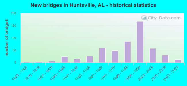
- New bridges - historical statistics
- 21900-1909
- 31910-1919
- 131920-1929
- 381930-1939
- 241940-1949
- 421950-1959
- 711960-1969
- 551970-1979
- 1011980-1989
- 1771990-1999
- 662000-2009
- 352010-2019
- 122020-2022
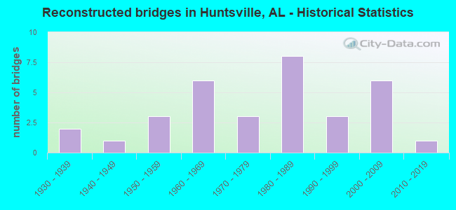
- Reconstructed bridges - Historical Statistics
- 21930-1939
- 11940-1949
- 31950-1959
- 61960-1969
- 31970-1979
- 81980-1989
- 31990-1999
- 62000-2009
- 12010-2019
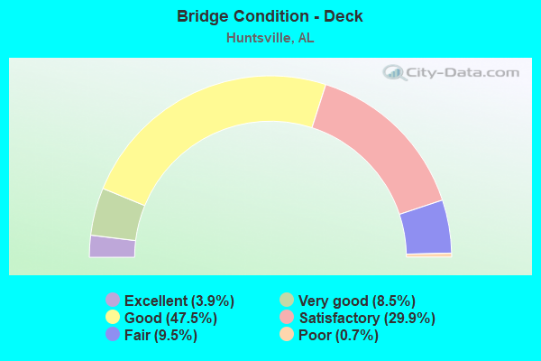
- Bridge Condition - Deck
- 3.9%Excellent
- 8.5%Very good
- 47.5%Good
- 29.9%Satisfactory
- 9.5%Fair
- 0.7%Poor
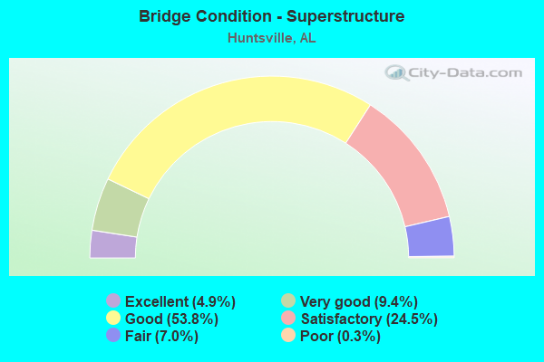
- Bridge Condition - Superstructure
- 4.9%Excellent
- 9.4%Very good
- 53.8%Good
- 24.5%Satisfactory
- 7.0%Fair
- 0.3%Poor
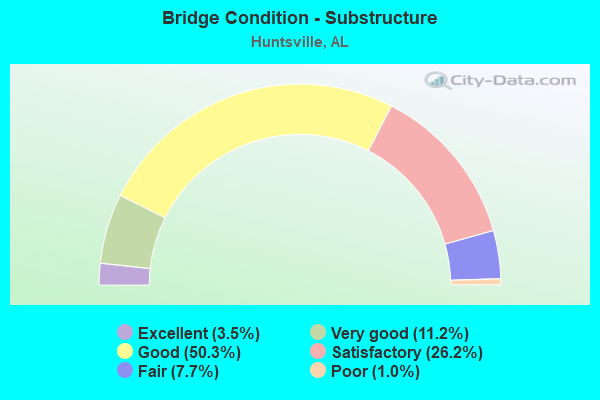
- Bridge Condition - Substructure
- 3.5%Excellent
- 11.2%Very good
- 50.3%Good
- 26.2%Satisfactory
- 7.7%Fair
- 1.0%Poor
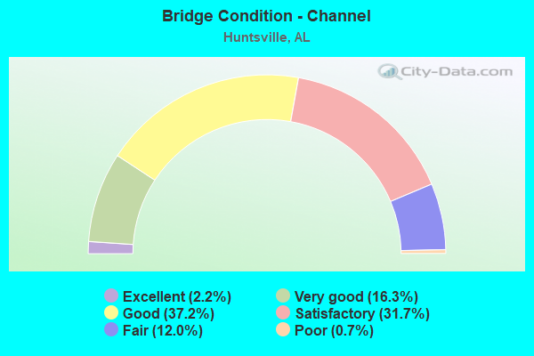
- Bridge Condition - Channel
- 2.2%Excellent
- 16.3%Very good
- 37.2%Good
- 31.7%Satisfactory
- 12.0%Fair
- 0.7%Poor
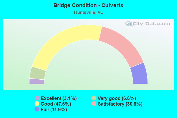
- Bridge Condition - Culverts
- 3.1%Excellent
- 6.6%Very good
- 47.6%Good
- 30.8%Satisfactory
- 11.9%Fair
Find on map >> Show street view
Structure Number: 1876, Location: 6765 FT N JCT 431 (Lat: 34.464167, Lng: -86.359286), Route carried "on" structure: County highway 472, Year Built: 1938, Status: Open, Structure Length: 3.17m (10.40ft), Average Daily Traffic: 150 (year 1994), Truck Traffic: 1%, Average Future Daily Traffic: 280 (year 2042), Design Load: H 10, Features Intersected: BRANCH, Facility Carried by Structure: COUNTY HIGHWAY147
Minimum Vertical Clearance: 30+ m (98+ ft), Kilometerpoint: 0.010, Lanes on structure: 2, Owner: County Highway Agency, Approaching Roadway Width: 7.9m (25.9ft), Material/Design: Concrete, Design/Construction: Culvert, Number Of Spans In Main Unit: 7, Length of Maximum Span: 4.0m (13.1ft)
Condition: Channel: Good, Culverts: Fair, Operating Rating: 43.5 metric tons, Method Used To Determine Operating Rating: Field evaluation and documented engineering judgment, Inventory Rating: 32.7 metric tons, Method Used To Determine Inventory Rating: Field evaluation and documented engineering judgment, Structural Evaluation: Somewhat better than minimum adequacy, Waterway Adequacy: Better than present minimum criteria, Approach Roadway Alignment: Equal to present desirable criteria, Length Of Structure Improvement: 4.03m (13.22ft), Designated Inspection Frequency: Every 24 months, Inspection Date: January 2022, Bridge Improvement Cost: $559,000, Roadway Improvement Cost: $56,000, Total Project Cost: $615,000 ( Estimate for 2022), Deck Structure Type: Concrete Cast-file-Place
Find on map >> Show street view
Structure Number: 1891, Location: 4 MI NW OF SLOCOMB (Lat: 31.163756, Lng: -85.621250), Route carried "on" structure: County highway , Year Built: 1939, Year Reconstructed: 1992, Status: Posted for load, Structure Length: 0.91m (2.99ft), Average Daily Traffic: 50 (year 2020), Average Future Daily Traffic: 75 (year 2040), Design Load: H 15, Features Intersected: PATES CREEK BRANCH, Facility Carried by Structure: BALD HILL ROAD
Minimum Vertical Clearance: 30+ m (98+ ft), Kilometerpoint: 0.010, Lanes on structure: 1, Owner: County Highway Agency, Approaching Roadway Width: 6.1m (20.0ft), Material/Design: Wood or Timber, Design/Construction: Stringer/Multi-beam, Number Of Spans In Main Unit: 2, Length of Maximum Span: 4.6m (15.1ft), Curb-To-Curb Width: 4.6m (15.1ft), Out-to-Out Width: 5.0m (16.4ft)
Condition: Deck: Satisfactory, Superstructure: Good, Substructure: Satisfactory, Channel: Satisfactory, Operating Rating: 28.7 metric tons, Method Used To Determine Operating Rating: Allowable Stress (AS), Inventory Rating: 21.1 metric tons, Method Used To Determine Inventory Rating: Allowable Stress (AS), Structural Evaluation: Equal to present minimum criteria, Deck Geometry: Better than present minimum criteria, Waterway Adequacy: Equal to present minimum criteria, Approach Roadway Alignment: Equal to present minimum criteria, Bridge Posting: Required (Relationship of Operating Rating to Maximum Legal Load: 30.0 - 39.9% below), Length Of Structure Improvement: 1.58m (5.18ft), Designated Inspection Frequency: Every 24 months, Other Special Inspection Frequency: Every 12 months, Inspection Date: August 2020, Other Special Inspection Date: August 2021, Bridge Improvement Cost: $173,000, Roadway Improvement Cost: $17,000, Total Project Cost: $190,000 ( Estimate for 2022), Deck Structure Type: Wood or Timber, Wearing Surface/Protective System: Wearing Surface: Wood or Timber
Find on map >> Show street view
Structure Number: 1932, Location: 2.9 MI N JCT SR 86 (Lat: 33.299267, Lng: -88.067800), Route carried "on" structure: State highway 17, Year Built: 1939, Status: Open, Structure Length: 1.78m (5.84ft), Average Daily Traffic: 3,429 (year 2020), Truck Traffic: 7%, Average Future Daily Traffic: 3,340 (year 2040), Design Load: H 15, Features Intersected: Strattons Branch
Minimum Vertical Clearance: 30+ m (98+ ft), Kilometerpoint: 326.999, Lanes on structure: 2, Base Highway Network: Yes, Owner: State Highway Agency, Approaching Roadway Width: 8.8m (28.9ft), Material/Design: Steel continuous, Design/Construction: Stringer/Multi-beam, Number Of Spans In Main Unit: 3, Length of Maximum Span: 5.8m (19.0ft), Curb or Sidewalk Widths: Left: 0.2m (0.7ft), Right: 0.2m (0.7ft), Curb-To-Curb Width: 7.3m (24.0ft), Out-to-Out Width: 8.4m (27.6ft)
Condition: Deck: Satisfactory, Superstructure: Satisfactory, Substructure: Satisfactory, Channel: Good, Operating Rating: 57.2 metric tons, Method Used To Determine Operating Rating: Load Factor (LF), Inventory Rating: 34.3 metric tons, Method Used To Determine Inventory Rating: Load Factor (LF), Structural Evaluation: Equal to present minimum criteria, Deck Geometry: High priority of replacement, Waterway Adequacy: Equal to present desirable criteria, Approach Roadway Alignment: Meets minimum limits, Length Of Structure Improvement: 2.49m (8.17ft), Designated Inspection Frequency: Every 24 months, Inspection Date: March 2022, Bridge Improvement Cost: $461,000, Roadway Improvement Cost: $46,000, Total Project Cost: $507,000 ( Estimate for 2022), Deck Structure Type: Concrete Cast-file-Place, Wearing Surface/Protective System: Wearing Surface: Bituminous
Find on map >> Show street view
Structure Number: 1933, Location: 3.7 MI N JCT SR 86 (Lat: 33.308783, Lng: -88.059083), Route carried "on" structure: State highway 17, Year Built: 1939, Status: Open, Structure Length: 2.06m (6.76ft), Average Daily Traffic: 3,429 (year 2016), Truck Traffic: 7%, Average Future Daily Traffic: 3,340 (year 2040), Design Load: H 15, Features Intersected: Kilpatrick Creek
Minimum Vertical Clearance: 30+ m (98+ ft), Kilometerpoint: 328.317, Lanes on structure: 2, Base Highway Network: Yes, Owner: State Highway Agency, Approaching Roadway Width: 8.8m (28.9ft), Material/Design: Steel continuous, Design/Construction: Stringer/Multi-beam, Number Of Spans In Main Unit: 3, Length of Maximum Span: 6.7m (22.0ft), Curb or Sidewalk Widths: Left: 0.2m (0.7ft), Right: 0.2m (0.7ft), Curb-To-Curb Width: 7.3m (24.0ft), Out-to-Out Width: 8.4m (27.6ft)
Condition: Deck: Satisfactory, Superstructure: Satisfactory, Substructure: Satisfactory, Channel: Good, Operating Rating: 47.1 metric tons, Method Used To Determine Operating Rating: Load Factor (LF), Inventory Rating: 28.0 metric tons, Method Used To Determine Inventory Rating: Load Factor (LF), Structural Evaluation: Equal to present minimum criteria, Deck Geometry: High priority of replacement, Waterway Adequacy: Equal to present minimum criteria, Approach Roadway Alignment: Better than present minimum criteria, Length Of Structure Improvement: 2.82m (9.25ft), Designated Inspection Frequency: Every 24 months, Inspection Date: March 2022, Bridge Improvement Cost: $522,000, Roadway Improvement Cost: $52,000, Total Project Cost: $574,000 ( Estimate for 2022), Deck Structure Type: Concrete Cast-file-Place, Wearing Surface/Protective System: Wearing Surface: Bituminous
Find on map >> Show street view
Structure Number: 1934, Location: 5.0 MI S JCT US 82 (Lat: 33.317100, Lng: -88.048383), Route carried "on" structure: State highway 17, Year Built: 1939, Status: Open, Structure Length: 2.06m (6.76ft), Average Daily Traffic: 3,429 (year 2016), Truck Traffic: 7%, Average Future Daily Traffic: 3,340 (year 2040), Design Load: H 15, Features Intersected: Johnsons Branch
Minimum Vertical Clearance: 30+ m (98+ ft), Kilometerpoint: 329.682, Lanes on structure: 2, Base Highway Network: Yes, Owner: State Highway Agency, Approaching Roadway Width: 7.3m (24.0ft), Material/Design: Steel continuous, Design/Construction: Stringer/Multi-beam, Number Of Spans In Main Unit: 3, Length of Maximum Span: 6.7m (22.0ft), Curb or Sidewalk Widths: Left: 0.2m (0.7ft), Right: 0.2m (0.7ft), Curb-To-Curb Width: 7.3m (24.0ft), Out-to-Out Width: 8.4m (27.6ft)
Condition: Deck: Satisfactory, Superstructure: Satisfactory, Substructure: Satisfactory, Channel: Satisfactory, Operating Rating: 48.4 metric tons, Method Used To Determine Operating Rating: Load Factor (LF), Inventory Rating: 28.9 metric tons, Method Used To Determine Inventory Rating: Load Factor (LF), Structural Evaluation: Equal to present minimum criteria, Deck Geometry: High priority of replacement, Waterway Adequacy: Equal to present minimum criteria, Approach Roadway Alignment: Equal to present minimum criteria, Length Of Structure Improvement: 2.82m (9.25ft), Designated Inspection Frequency: Every 24 months, Inspection Date: March 2022, Bridge Improvement Cost: $522,000, Roadway Improvement Cost: $52,000, Total Project Cost: $574,000 ( Estimate for 2022), Deck Structure Type: Concrete Cast-file-Place, Wearing Surface/Protective System: Wearing Surface: Bituminous
Find on map >> Show street view
Structure Number: 1966, Location: 1.5MI.N.OF FRISCO CITY (Lat: 31.452567, Lng: -87.373089), Route carried "on" structure: State highway 21, Year Built: 1939, Status: Open, Structure Length: 1.22m (4.00ft), Average Daily Traffic: 5,070 (year 2013), Truck Traffic: 5%, Average Future Daily Traffic: 6,323 (year 2033), Design Load: H 15, Features Intersected: BRANCH
Minimum Vertical Clearance: 30+ m (98+ ft), Kilometerpoint: 58.030, Lanes on structure: 2, Base Highway Network: Yes, Owner: State Highway Agency, Approaching Roadway Width: 7.3m (24.0ft), Material/Design: Concrete, Design/Construction: Culvert, Number Of Spans In Main Unit: 4, Length of Maximum Span: 3.0m (9.8ft)
Condition: Channel: Good, Culverts: Good, Operating Rating: 81.1 metric tons, Method Used To Determine Operating Rating: Load Factor (LF), Inventory Rating: 48.6 metric tons, Method Used To Determine Inventory Rating: Load Factor (LF), Structural Evaluation: Better than present minimum criteria, Waterway Adequacy: Better than present minimum criteria, Approach Roadway Alignment: Equal to present desirable criteria, Length Of Structure Improvement: 1.89m (6.20ft), Designated Inspection Frequency: Every 24 months, Inspection Date: September 2021, Bridge Improvement Cost: $524,000, Roadway Improvement Cost: $52,000, Total Project Cost: $576,000 ( Estimate for 2022)
Find on map >> Show street view
Structure Number: 1975, Location: 6.4 MI. N.OF FURMAN (Lat: 32.001811, Lng: -86.868489), Route carried "on" structure: State highway 21, Year Built: 1939, Status: Open, Structure Length: 0.67m (2.20ft), Average Daily Traffic: 900 (year 2013), Truck Traffic: 14%, Average Future Daily Traffic: 1,122 (year 2033), Design Load: H 15, Features Intersected: BRANCH
Minimum Vertical Clearance: 30+ m (98+ ft), Kilometerpoint: 155.989, Lanes on structure: 2, Owner: State Highway Agency, Approaching Roadway Width: 9.8m (32.2ft), Material/Design: Concrete, Design/Construction: Culvert, Number Of Spans In Main Unit: 2, Length of Maximum Span: 3.0m (9.8ft)
Condition: Channel: Satisfactory, Culverts: Satisfactory, Operating Rating: 58.1 metric tons, Method Used To Determine Operating Rating: Load Factor (LF), Inventory Rating: 34.8 metric tons, Method Used To Determine Inventory Rating: Load Factor (LF), Structural Evaluation: Equal to present minimum criteria, Waterway Adequacy: Better than present minimum criteria, Approach Roadway Alignment: Equal to present desirable criteria, Length Of Structure Improvement: 1.30m (4.27ft), Designated Inspection Frequency: Every 24 months, Inspection Date: November 2021, Bridge Improvement Cost: $556,000, Roadway Improvement Cost: $56,000, Total Project Cost: $612,000 ( Estimate for 2022)
Find on map >> Show street view
Structure Number: 2017, Location: 1.2 MI W US HWY 72W (Lat: 34.764108, Lng: -86.679056), Route carried "on" structure: County highway 52, Year Built: 1939, Status: Open, Structure Length: 1.07m (3.51ft), Average Daily Traffic: 600 (year 1990), Truck Traffic: 1%, Average Future Daily Traffic: 840 (year 2034), Design Load: H 15, Features Intersected: OAKWOOD BRANCH, Facility Carried by Structure: JOHNS RD
Minimum Vertical Clearance: 30+ m (98+ ft), Kilometerpoint: 0.010, Lanes on structure: 2, Owner: County Highway Agency, Approaching Roadway Width: 7.9m (25.9ft), Material/Design: Masonry, Design/Construction: Culvert, Number Of Spans In Main Unit: 3, Length of Maximum Span: 3.0m (9.8ft), Curb-To-Curb Width: 6.2m (20.3ft), Out-to-Out Width: 6.7m (22.0ft)
Condition: Channel: Satisfactory, Culverts: Satisfactory, Operating Rating: 32.7 metric tons, Method Used To Determine Operating Rating: Field evaluation and documented engineering judgment, Inventory Rating: 23.6 metric tons, Method Used To Determine Inventory Rating: Field evaluation and documented engineering judgment, Structural Evaluation: Equal to present minimum criteria, Deck Geometry: High priority of corrective action, Waterway Adequacy: Meets minimum limits, Approach Roadway Alignment: Somewhat better than minimum adequacy, Length Of Structure Improvement: 1.74m (5.71ft), Designated Inspection Frequency: Every 24 months, Inspection Date: May 2020, Bridge Improvement Cost: $222,000, Roadway Improvement Cost: $22,000, Total Project Cost: $244,000 ( Estimate for 2022)
Find on map >> Show street view
Structure Number: 2049, Location: PHILADELPHIA CHURCH RD. (Lat: 33.924603, Lng: -85.540906), Route carried "on" structure: County highway 111, Year Built: 1939, Status: Open, Structure Length: 0.73m (2.40ft), Average Daily Traffic: 202 (year 2005), Truck Traffic: 1%, Average Future Daily Traffic: 404 (year 2040), Features Intersected: BRANCH, Facility Carried by Structure: Philad Church Rd.
Minimum Vertical Clearance: 30+ m (98+ ft), Kilometerpoint: 0.010, Lanes on structure: 2, Owner: County Highway Agency, Approaching Roadway Width: 7.0m (23.0ft), Skew: 1 degrees, Material/Design: Steel, Design/Construction: Stringer/Multi-beam, Number Of Spans In Main Unit: 1, Length of Maximum Span: 3.7m (12.1ft), Curb-To-Curb Width: 6.6m (21.7ft), Out-to-Out Width: 6.8m (22.3ft)
Condition: Deck: Fair, Superstructure: Fair, Substructure: Fair, Channel: Satisfactory, Operating Rating: 65.5 metric tons, Method Used To Determine Operating Rating: Allowable Stress (AS), Inventory Rating: 47.2 metric tons, Method Used To Determine Inventory Rating: Allowable Stress (AS), Structural Evaluation: Somewhat better than minimum adequacy, Deck Geometry: Meets minimum limits, Waterway Adequacy: Better than present minimum criteria, Approach Roadway Alignment: Meets minimum limits, Length Of Structure Improvement: 1.38m (4.53ft), Designated Inspection Frequency: Every 24 months, Inspection Date: December 2020, Bridge Improvement Cost: $208,000, Roadway Improvement Cost: $21,000, Total Project Cost: $229,000 ( Estimate for 2022), Deck Structure Type: Concrete Cast-file-Place, Wearing Surface/Protective System: Wearing Surface: Bituminous
Find on map >> Show street view
Structure Number: 2068, Location: 0.2 MI NO CO RD 1425 (Lat: 34.793386, Lng: -86.450994), Route carried "on" structure: County highway 258, Year Built: 1939, Status: Posted for load, Structure Length: 0.91m (2.99ft), Average Daily Traffic: 600 (year 1992), Truck Traffic: 1%, Average Future Daily Traffic: 795 (year 2040), Design Load: H 15, Features Intersected: BANJO MARTIN BRANCH, Facility Carried by Structure: MAYSVILLE RD
Minimum Vertical Clearance: 30+ m (98+ ft), Kilometerpoint: 0.010, Lanes on structure: 2, Owner: County Highway Agency, Approaching Roadway Width: 8.5m (27.9ft), Material/Design: Steel, Design/Construction: Stringer/Multi-beam, Number Of Spans In Main Unit: 1, Length of Maximum Span: 9.1m (29.9ft), Curb-To-Curb Width: 7.3m (24.0ft), Out-to-Out Width: 8.3m (27.2ft)
Condition: Deck: Satisfactory, Superstructure: Satisfactory, Substructure: Fair, Channel: Poor, Operating Rating: 20.3 metric tons, Method Used To Determine Operating Rating: Allowable Stress (AS), Inventory Rating: 10.5 metric tons, Method Used To Determine Inventory Rating: Allowable Stress (AS), Structural Evaluation: High priority of replacement, Deck Geometry: Meets minimum limits, Waterway Adequacy: Equal to present minimum criteria, Approach Roadway Alignment: Equal to present minimum criteria, Bridge Posting: Required (Relationship of Operating Rating to Maximum Legal Load: > 39.9% below), Length Of Structure Improvement: 1.58m (5.18ft), Designated Inspection Frequency: Every 24 months, Other Special Inspection Frequency: Every 12 months, Inspection Date: September 2020, Other Special Inspection Date: September 2021, Bridge Improvement Cost: $293,000, Roadway Improvement Cost: $29,000, Total Project Cost: $322,000 ( Estimate for 2022), Deck Structure Type: Concrete Cast-file-Place, Wearing Surface/Protective System: Wearing Surface: Bituminous
Find on map >> Show street view
Structure Number: 2076, Location: 1.0 MI NO CO RD 1335 (Lat: 34.718892, Lng: -86.489356), Route carried "on" structure: County highway 332, Year Built: 1939, Status: Open, Structure Length: 1.19m (3.90ft), Average Daily Traffic: 650 (year 1992), Truck Traffic: 1%, Average Future Daily Traffic: 955 (year 2040), Design Load: H 15, Features Intersected: HILL BRANCH, Facility Carried by Structure: DUG HILL RD
Minimum Vertical Clearance: 30+ m (98+ ft), Kilometerpoint: 0.010, Lanes on structure: 2, Owner: County Highway Agency, Approaching Roadway Width: 7.3m (24.0ft), Skew: 4 degrees, Material/Design: Masonry, Design/Construction: Culvert, Number Of Spans In Main Unit: 2, Length of Maximum Span: 3.7m (12.1ft), Curb-To-Curb Width: 6.2m (20.3ft), Out-to-Out Width: 6.6m (21.7ft)
Condition: Channel: Fair, Culverts: Fair, Operating Rating: 32.7 metric tons, Method Used To Determine Operating Rating: Field evaluation and documented engineering judgment, Inventory Rating: 23.6 metric tons, Method Used To Determine Inventory Rating: Field evaluation and documented engineering judgment, Structural Evaluation: Somewhat better than minimum adequacy, Deck Geometry: High priority of corrective action, Waterway Adequacy: Somewhat better than minimum adequacy, Approach Roadway Alignment: Somewhat better than minimum adequacy, Length Of Structure Improvement: 1.86m (6.10ft), Designated Inspection Frequency: Every 24 months, Inspection Date: September 2020, Bridge Improvement Cost: $323,000, Roadway Improvement Cost: $32,000, Total Project Cost: $355,000 ( Estimate for 2022)
Find on map >> Show street view
Structure Number: 2077, Location: 0.2 MI SO CO RD 1332 (Lat: 34.701969, Lng: -86.488956), Route carried "on" structure: County highway 335, Year Built: 1939, Status: Posted for load, Structure Length: 0.85m (2.79ft), Average Daily Traffic: 250 (year 1992), Truck Traffic: 1%, Average Future Daily Traffic: 300 (year 2035), Design Load: H 15, Features Intersected: HARRISON BRANCH, Facility Carried by Structure: KING DRAKE RD
Minimum Vertical Clearance: 30+ m (98+ ft), Kilometerpoint: 0.010, Lanes on structure: 2, Owner: County Highway Agency, Approaching Roadway Width: 7.3m (24.0ft), Skew: 2 degrees, Material/Design: Steel, Design/Construction: Stringer/Multi-beam, Number Of Spans In Main Unit: 1, Length of Maximum Span: 8.5m (27.9ft), Curb-To-Curb Width: 5.9m (19.4ft), Out-to-Out Width: 6.3m (20.7ft)
Condition: Deck: Satisfactory, Superstructure: Fair, Substructure: Satisfactory, Channel: Satisfactory, Operating Rating: 35.2 metric tons, Method Used To Determine Operating Rating: Allowable Stress (AS), Inventory Rating: 22.1 metric tons, Method Used To Determine Inventory Rating: Allowable Stress (AS), Structural Evaluation: Somewhat better than minimum adequacy, Deck Geometry: High priority of corrective action, Waterway Adequacy: Equal to present minimum criteria, Approach Roadway Alignment: Somewhat better than minimum adequacy, Bridge Posting: Required (Relationship of Operating Rating to Maximum Legal Load: 20.0 - 29.9% below), Length Of Structure Improvement: 1.51m (4.95ft), Designated Inspection Frequency: Every 24 months, Other Special Inspection Frequency: Every 12 months, Inspection Date: Febuary 2021, Other Special Inspection Date: Febuary 2022, Bridge Improvement Cost: $208,000, Roadway Improvement Cost: $21,000, Total Project Cost: $229,000 ( Estimate for 2022), Deck Structure Type: Concrete Cast-file-Place, Wearing Surface/Protective System: Wearing Surface: Bituminous
Find on map >> Show street view
Structure Number: 2083, Location: 0.2 MI S JCT FAS 03 (Lat: 34.804758, Lng: -86.771656), Route carried "on" structure: County highway 489, Year Built: 1939, Status: Open, Structure Length: 0.73m (2.40ft), Average Daily Traffic: 220 (year 1992), Truck Traffic: 1%, Average Future Daily Traffic: 300 (year 2035), Design Load: H 15, Features Intersected: DAVIS BRANCH, Facility Carried by Structure: SAM THOMAS RD
Minimum Vertical Clearance: 30+ m (98+ ft), Kilometerpoint: 0.010, Lanes on structure: 2, Owner: County Highway Agency, Approaching Roadway Width: 7.3m (24.0ft), Material/Design: Masonry, Design/Construction: Culvert, Number Of Spans In Main Unit: 2, Length of Maximum Span: 3.7m (12.1ft), Curb-To-Curb Width: 5.6m (18.4ft), Out-to-Out Width: 6.1m (20.0ft)
Condition: Channel: Good, Culverts: Good, Operating Rating: 32.7 metric tons, Method Used To Determine Operating Rating: Field evaluation and documented engineering judgment, Inventory Rating: 23.6 metric tons, Method Used To Determine Inventory Rating: Field evaluation and documented engineering judgment, Structural Evaluation: Equal to present minimum criteria, Deck Geometry: High priority of corrective action, Waterway Adequacy: Somewhat better than minimum adequacy, Approach Roadway Alignment: Equal to present minimum criteria, Length Of Structure Improvement: 1.38m (4.53ft), Designated Inspection Frequency: Every 24 months, Inspection Date: November 2020, Bridge Improvement Cost: $254,000, Roadway Improvement Cost: $25,000, Total Project Cost: $279,000 ( Estimate for 2022)
Find on map >> Show street view
Structure Number: 2157, Location: SEC 28,T11N,R22E (Lat: 31.901861, Lng: -85.850964), Route carried "on" structure: County highway , Year Built: 1985, Status: Posted for load, Structure Length: 1.86m (6.10ft), Average Daily Traffic: 30 (year 2001), Truck Traffic: 6%, Average Future Daily Traffic: 40 (year 2035), Features Intersected: GORES BRANCH, Facility Carried by Structure: COUNTY ROAD 6612
Minimum Vertical Clearance: 30+ m (98+ ft), Kilometerpoint: 0.010, Lanes on structure: 1, Owner: County Highway Agency, Approaching Roadway Width: 6.7m (22.0ft), Material/Design: Wood or Timber, Design/Construction: Stringer/Multi-beam, Number Of Spans In Main Unit: 4, Length of Maximum Span: 4.6m (15.1ft), Curb-To-Curb Width: 4.3m (14.1ft), Out-to-Out Width: 4.6m (15.1ft)
Condition: Deck: Good, Superstructure: Good, Substructure: Good, Channel: Satisfactory, Operating Rating: 18.4 metric tons, Method Used To Determine Operating Rating: Allowable Stress (AS), Inventory Rating: 16.1 metric tons, Method Used To Determine Inventory Rating: Allowable Stress (AS), Structural Evaluation: Meets minimum limits, Deck Geometry: Equal to present minimum criteria, Waterway Adequacy: Better than present minimum criteria, Approach Roadway Alignment: Equal to present minimum criteria, Bridge Posting: Required (Relationship of Operating Rating to Maximum Legal Load: > 39.9% below), Length Of Structure Improvement: 2.58m (8.46ft), Designated Inspection Frequency: Every 24 months, Other Special Inspection Frequency: Every 12 months, Inspection Date: October 2020, Other Special Inspection Date: October 2021, Bridge Improvement Cost: $265,000, Roadway Improvement Cost: $27,000, Total Project Cost: $292,000 ( Estimate for 2022), Deck Structure Type: Wood or Timber, Wearing Surface/Protective System: Wearing Surface: Wood or Timber
Find on map >> Show street view
Structure Number: 2433, Location: 0.1 MI N ALA HWY 20 (Lat: 34.698333, Lng: -86.706667), Route carried "on" structure: City street , Year Built: 1940, Status: Open, Structure Length: 0.91m (2.99ft), Average Daily Traffic: 11,100 (year 2016), Truck Traffic: 3%, Average Future Daily Traffic: 15,540 (year 2036), Design Load: H 15, Features Intersected: INDIAN CREEK, Facility Carried by Structure: SLAUGHTER RD
Minimum Vertical Clearance: 30+ m (98+ ft), Kilometerpoint: 0.000, Lanes on structure: 2, Owner: City or Municipal Highway Agency, Approaching Roadway Width: 9.1m (29.9ft), Material/Design: Concrete, Design/Construction: Tee Beam, Number Of Spans In Main Unit: 1, Length of Maximum Span: 9.1m (29.9ft), Curb-To-Curb Width: 7.3m (24.0ft), Out-to-Out Width: 8.2m (26.9ft)
Condition: Deck: Satisfactory, Superstructure: Satisfactory, Substructure: Satisfactory, Channel: Fair, Operating Rating: 41.7 metric tons, Method Used To Determine Operating Rating: Load Factor (LF), Inventory Rating: 25.1 metric tons, Method Used To Determine Inventory Rating: Load Factor (LF), Structural Evaluation: Equal to present minimum criteria, Deck Geometry: High priority of replacement, Waterway Adequacy: Somewhat better than minimum adequacy, Approach Roadway Alignment: Equal to present minimum criteria, Length Of Structure Improvement: 1.58m (5.18ft), Designated Inspection Frequency: Every 24 months, Inspection Date: November 2021, Bridge Improvement Cost: $282,000, Roadway Improvement Cost: $28,000, Total Project Cost: $310,000 ( Estimate for 2022), Deck Structure Type: Concrete Cast-file-Place, Wearing Surface/Protective System: Wearing Surface: Bituminous
Find on map >> Show street view
Structure Number: 2434, Location: 0.2 MI N ALA HWY 20 (Lat: 34.698333, Lng: -86.706667), Route carried "on" structure: City street , Year Built: 1940, Status: Open, Structure Length: 0.73m (2.40ft), Average Daily Traffic: 11,100 (year 2016), Truck Traffic: 3%, Average Future Daily Traffic: 15,540 (year 2036), Design Load: H 15, Features Intersected: INDIAN CREEK, Facility Carried by Structure: SLAUGHTER RD
Minimum Vertical Clearance: 30+ m (98+ ft), Kilometerpoint: 0.000, Lanes on structure: 2, Owner: City or Municipal Highway Agency, Approaching Roadway Width: 6.4m (21.0ft), Material/Design: Concrete, Design/Construction: Slab, Number Of Spans In Main Unit: 2, Length of Maximum Span: 3.7m (12.1ft), Curb-To-Curb Width: 6.8m (22.3ft), Out-to-Out Width: 7.3m (24.0ft)
Condition: Deck: Satisfactory, Superstructure: Satisfactory, Substructure: Satisfactory, Channel: Satisfactory, Operating Rating: 32.7 metric tons, Method Used To Determine Operating Rating: Field evaluation and documented engineering judgment, Inventory Rating: 23.6 metric tons, Method Used To Determine Inventory Rating: Field evaluation and documented engineering judgment, Structural Evaluation: Somewhat better than minimum adequacy, Deck Geometry: High priority of replacement, Waterway Adequacy: Somewhat better than minimum adequacy, Approach Roadway Alignment: Equal to present minimum criteria, Length Of Structure Improvement: 1.38m (4.53ft), Designated Inspection Frequency: Every 24 months, Inspection Date: November 2021, Bridge Improvement Cost: $227,000, Roadway Improvement Cost: $23,000, Total Project Cost: $250,000 ( Estimate for 2022)
Find on map >> Show street view
Structure Number: 2491, Location: 1.0 MI SO US HWY 72EAST (Lat: 34.732481, Lng: -86.457608), Route carried "on" structure: County highway 303, Year Built: 1940, Status: Open, Structure Length: 0.91m (2.99ft), Average Daily Traffic: 60 (year 1992), Average Future Daily Traffic: 100 (year 2034), Design Load: H 15, Features Intersected: MOONTOWN BRANCH, Facility Carried by Structure: MOONTOWN RD
Minimum Vertical Clearance: 30+ m (98+ ft), Kilometerpoint: 0.010, Lanes on structure: 2, Owner: County Highway Agency, Approaching Roadway Width: 7.3m (24.0ft), Skew: 2 degrees, Material/Design: Masonry, Design/Construction: Culvert, Number Of Spans In Main Unit: 2, Length of Maximum Span: 4.3m (14.1ft), Curb-To-Curb Width: 5.6m (18.4ft), Out-to-Out Width: 6.0m (19.7ft)
Condition: Channel: Fair, Culverts: Fair, Operating Rating: 32.7 metric tons, Method Used To Determine Operating Rating: Field evaluation and documented engineering judgment, Inventory Rating: 23.6 metric tons, Method Used To Determine Inventory Rating: Field evaluation and documented engineering judgment, Structural Evaluation: Somewhat better than minimum adequacy, Deck Geometry: Meets minimum limits, Waterway Adequacy: Somewhat better than minimum adequacy, Approach Roadway Alignment: Meets minimum limits, Length Of Structure Improvement: 1.58m (5.18ft), Designated Inspection Frequency: Every 24 months, Inspection Date: January 2022, Bridge Improvement Cost: $182,000, Roadway Improvement Cost: $18,000, Total Project Cost: $200,000 ( Estimate for 2022)
Find on map >> Show street view
Structure Number: 2492, Location: 0.2 MI WEST CO.RD. 1307 (Lat: 34.756997, Lng: -86.430969), Route carried "on" structure: County highway 306, Year Built: 1940, Status: Posted for load, Structure Length: 1.04m (3.41ft), Average Daily Traffic: 650 (year 1992), Truck Traffic: 1%, Average Future Daily Traffic: 1,020 (year 2034), Design Load: H 15, Features Intersected: BURNS SPRING BRANCH, Facility Carried by Structure: BROWNSBORO RD
Minimum Vertical Clearance: 30+ m (98+ ft), Kilometerpoint: 0.010, Lanes on structure: 2, Owner: County Highway Agency, Approaching Roadway Width: 8.5m (27.9ft), Skew: 4 degrees, Material/Design: Concrete, Design/Construction: Tee Beam, Number Of Spans In Main Unit: 1, Length of Maximum Span: 10.4m (34.1ft), Curb-To-Curb Width: 7.3m (24.0ft), Out-to-Out Width: 7.8m (25.6ft)
Condition: Deck: Satisfactory, Superstructure: Good, Substructure: Satisfactory, Channel: Satisfactory, Operating Rating: 35.3 metric tons, Method Used To Determine Operating Rating: Load Factor (LF), Inventory Rating: 21.1 metric tons, Method Used To Determine Inventory Rating: Load Factor (LF), Structural Evaluation: Somewhat better than minimum adequacy, Deck Geometry: Meets minimum limits, Waterway Adequacy: Equal to present minimum criteria, Approach Roadway Alignment: Equal to present minimum criteria, Bridge Posting: Required (Relationship of Operating Rating to Maximum Legal Load: 20.0 - 29.9% below), Length Of Structure Improvement: 1.71m (5.61ft), Designated Inspection Frequency: Every 24 months, Other Special Inspection Frequency: Every 12 months, Inspection Date: June 2020, Other Special Inspection Date: June 2021, Bridge Improvement Cost: $294,000, Roadway Improvement Cost: $29,000, Total Project Cost: $323,000 ( Estimate for 2022), Deck Structure Type: Concrete Cast-file-Place, Wearing Surface/Protective System: Wearing Surface: Bituminous
Find on map >> Show street view
Structure Number: 2572, Location: 1.7 MI E JCT ALA HWY 53 (Lat: 34.822589, Lng: -86.665389), Route carried "on" structure: County highway 42, Year Built: 1941, Status: Open, Structure Length: 0.85m (2.79ft), Average Daily Traffic: 3,118 (year 2002), Truck Traffic: 1%, Average Future Daily Traffic: 3,741 (year 2034), Design Load: H 15, Features Intersected: FORK OF DRY CREEK, Facility Carried by Structure: BOB WADE LA
Minimum Vertical Clearance: 30+ m (98+ ft), Kilometerpoint: 0.010, Lanes on structure: 2, Owner: County Highway Agency, Approaching Roadway Width: 8.5m (27.9ft), Material/Design: Masonry, Design/Construction: Culvert, Number Of Spans In Main Unit: 2, Length of Maximum Span: 3.7m (12.1ft), Curb-To-Curb Width: 9.4m (30.8ft), Out-to-Out Width: 10.1m (33.1ft)
Condition: Channel: Satisfactory, Culverts: Satisfactory, Operating Rating: 32.7 metric tons, Method Used To Determine Operating Rating: Field evaluation and documented engineering judgment, Inventory Rating: 23.6 metric tons, Method Used To Determine Inventory Rating: Field evaluation and documented engineering judgment, Structural Evaluation: Equal to present minimum criteria, Deck Geometry: Meets minimum limits, Waterway Adequacy: Somewhat better than minimum adequacy, Approach Roadway Alignment: Better than present minimum criteria, Length Of Structure Improvement: 1.51m (4.95ft), Designated Inspection Frequency: Every 24 months, Inspection Date: August 2020, Bridge Improvement Cost: $288,000, Roadway Improvement Cost: $29,000, Total Project Cost: $317,000 ( Estimate for 2022)
Find on map >> Show street view
Structure Number: 2573, Location: 0.3 MI W JCT US HWY 231 (Lat: 34.829344, Lng: -86.575797), Route carried "on" structure: County highway 42, Year Built: 1941, Status: Posted for load, Structure Length: 0.85m (2.79ft), Average Daily Traffic: 750 (year 1992), Truck Traffic: 1%, Average Future Daily Traffic: 1,205 (year 2040), Design Load: H 15, Features Intersected: DEVILS BRANCH, Facility Carried by Structure: BOB WADE LA
Minimum Vertical Clearance: 30+ m (98+ ft), Kilometerpoint: 0.010, Lanes on structure: 2, Owner: County Highway Agency, Approaching Roadway Width: 8.5m (27.9ft), Material/Design: Steel, Design/Construction: Stringer/Multi-beam, Number Of Spans In Main Unit: 1, Length of Maximum Span: 8.5m (27.9ft), Curb-To-Curb Width: 7.3m (24.0ft), Out-to-Out Width: 8.3m (27.2ft)
Condition: Deck: Satisfactory, Superstructure: Satisfactory, Substructure: Satisfactory, Channel: Fair, Operating Rating: 40.3 metric tons, Method Used To Determine Operating Rating: Allowable Stress (AS), Inventory Rating: 25.3 metric tons, Method Used To Determine Inventory Rating: Allowable Stress (AS), Structural Evaluation: Equal to present minimum criteria, Deck Geometry: Meets minimum limits, Waterway Adequacy: Somewhat better than minimum adequacy, Approach Roadway Alignment: Somewhat better than minimum adequacy, Bridge Posting: Required (Relationship of Operating Rating to Maximum Legal Load: 10.0 - 19.9% below), Length Of Structure Improvement: 1.51m (4.95ft), Designated Inspection Frequency: Every 24 months, Other Special Inspection Frequency: Every 12 months, Inspection Date: October 2020, Other Special Inspection Date: October 2021, Bridge Improvement Cost: $280,000, Roadway Improvement Cost: $28,000, Total Project Cost: $308,000 ( Estimate for 2022), Deck Structure Type: Concrete Cast-file-Place
Find on map >> Show street view
Structure Number: 2623, Location: 0.1 MI W CO RD 1427 (Lat: 34.798881, Lng: -86.456006), Route carried "on" structure: County highway 426, Year Built: 1941, Status: Open, Structure Length: 0.73m (2.40ft), Average Daily Traffic: 115 (year 2001), Truck Traffic: 1%, Average Future Daily Traffic: 410 (year 2035), Design Load: H 15, Features Intersected: BERRY SPRING BRANCH, Facility Carried by Structure: ST CLAIR RD
Minimum Vertical Clearance: 30+ m (98+ ft), Kilometerpoint: 0.010, Lanes on structure: 2, Owner: County Highway Agency, Approaching Roadway Width: 7.3m (24.0ft), Skew: 4 degrees, Material/Design: Masonry, Design/Construction: Culvert, Number Of Spans In Main Unit: 2, Length of Maximum Span: 3.0m (9.8ft), Curb-To-Curb Width: 6.2m (20.3ft), Out-to-Out Width: 6.7m (22.0ft)
Condition: Channel: Satisfactory, Culverts: Fair, Operating Rating: 32.7 metric tons, Method Used To Determine Operating Rating: Field evaluation and documented engineering judgment, Inventory Rating: 23.6 metric tons, Method Used To Determine Inventory Rating: Field evaluation and documented engineering judgment, Structural Evaluation: Somewhat better than minimum adequacy, Deck Geometry: Meets minimum limits, Waterway Adequacy: Somewhat better than minimum adequacy, Approach Roadway Alignment: Somewhat better than minimum adequacy, Length Of Structure Improvement: 1.38m (4.53ft), Designated Inspection Frequency: Every 24 months, Other Special Inspection Frequency: Every 24 months, Inspection Date: September 2020, Other Special Inspection Date: September 2020, Bridge Improvement Cost: $175,000, Roadway Improvement Cost: $18,000, Total Project Cost: $193,000 ( Estimate for 2022)
Find on map >> Show street view
Structure Number: 2769, Location: 0.5 MI NO US HWY 72 E (Lat: 34.747764, Lng: -86.435858), Route carried "on" structure: County highway 307, Year Built: 1943, Status: Posted for load, Structure Length: 0.73m (2.40ft), Average Daily Traffic: 250 (year 1992), Truck Traffic: 1%, Average Future Daily Traffic: 365 (year 2037), Features Intersected: SECTION BRANCH, Facility Carried by Structure: STONE DRIVE
Minimum Vertical Clearance: 30+ m (98+ ft), Kilometerpoint: 0.010, Lanes on structure: 2, Owner: County Highway Agency, Approaching Roadway Width: 7.3m (24.0ft), Material/Design: Concrete, Design/Construction: Slab, Number Of Spans In Main Unit: 2, Length of Maximum Span: 3.7m (12.1ft), Curb-To-Curb Width: 6.1m (20.0ft), Out-to-Out Width: 6.4m (21.0ft)
Condition: Deck: Fair, Superstructure: Fair, Substructure: Fair, Channel: Fair, Operating Rating: 43.5 metric tons, Method Used To Determine Operating Rating: Field evaluation and documented engineering judgment, Inventory Rating: 32.7 metric tons, Method Used To Determine Inventory Rating: Field evaluation and documented engineering judgment, Structural Evaluation: Somewhat better than minimum adequacy, Deck Geometry: Meets minimum limits, Waterway Adequacy: Somewhat better than minimum adequacy, Approach Roadway Alignment: Somewhat better than minimum adequacy, Bridge Posting: Required (Relationship of Operating Rating to Maximum Legal Load: 10.0 - 19.9% below), Length Of Structure Improvement: 1.38m (4.53ft), Designated Inspection Frequency: Every 24 months, Other Special Inspection Frequency: Every 12 months, Inspection Date: June 2020, Other Special Inspection Date: June 2021, Bridge Improvement Cost: $198,000, Roadway Improvement Cost: $20,000, Total Project Cost: $218,000 ( Estimate for 2022), Deck Structure Type: Concrete Cast-file-Place
Find on map >> Show street view
Structure Number: 2856, Location: IVY ST W OF M F STADIUM (Lat: 34.705000, Lng: -86.606667), Route carried "on" structure: City street , Year Built: 1945, Status: Open, Structure Length: 0.73m (2.40ft), Average Daily Traffic: 3,175 (year 2017), Truck Traffic: 1%, Average Future Daily Traffic: 4,445 (year 2037), Design Load: H 10, Features Intersected: BRAHAN SPRING BRANCH, Facility Carried by Structure: IVY STREET
Minimum Vertical Clearance: 7.56m (24.80ft), Kilometerpoint: 0.010, Lanes on structure: 2, Owner: City or Municipal Highway Agency, Approaching Roadway Width: 11.9m (39.0ft), Skew: 3 degrees, Material/Design: Concrete, Design/Construction: Culvert, Number Of Spans In Main Unit: 2, Length of Maximum Span: 3.4m (11.2ft), Curb or Sidewalk Widths: Left: 1.3m (4.3ft), Right: 1.3m (4.3ft), Curb-To-Curb Width: 9.7m (31.8ft), Out-to-Out Width: 12.6m (41.3ft)
Condition: Channel: Good, Culverts: Satisfactory, Operating Rating: 59.1 metric tons, Method Used To Determine Operating Rating: Load Factor (LF), Inventory Rating: 35.4 metric tons, Method Used To Determine Inventory Rating: Load Factor (LF), Structural Evaluation: Equal to present minimum criteria, Deck Geometry: Meets minimum limits, Waterway Adequacy: Better than present minimum criteria, Approach Roadway Alignment: Better than present minimum criteria, Length Of Structure Improvement: 1.38m (4.53ft), Designated Inspection Frequency: Every 24 months, Inspection Date: April 2020, Bridge Improvement Cost: $374,000, Roadway Improvement Cost: $37,000, Total Project Cost: $411,000 ( Estimate for 2022), Wearing Surface/Protective System: Wearing Surface: Bituminous
Find on map >> Show street view
Structure Number: 2935, Location: SEC33 T3S R3W (Lat: 34.729667, Lng: -86.854000), Route carried "on" structure: City street 24, Year Built: 1934, Year Reconstructed: 1946, Status: Posted for load, Structure Length: 1.52m (4.99ft), Average Daily Traffic: 3,200 (year 2017), Truck Traffic: 3%, Average Future Daily Traffic: 4,480 (year 2037), Features Intersected: LIMESTONE CR RELIEF, Facility Carried by Structure: HSV-BRFERRY ROAD
Minimum Vertical Clearance: 30+ m (98+ ft), Kilometerpoint: 3.380, Lanes on structure: 2, Owner: City or Municipal Highway Agency, Approaching Roadway Width: 8.5m (27.9ft), Material/Design: Steel, Design/Construction: Stringer/Multi-beam, Number Of Spans In Main Unit: 2, Length of Maximum Span: 7.6m (24.9ft), Curb-To-Curb Width: 6.9m (22.6ft), Out-to-Out Width: 7.6m (24.9ft)
Condition: Deck: Satisfactory, Superstructure: Satisfactory, Substructure: Fair, Channel: Satisfactory, Operating Rating: 20.6 metric tons, Method Used To Determine Operating Rating: Load Factor (LF), Inventory Rating: 12.3 metric tons, Method Used To Determine Inventory Rating: Load Factor (LF), Structural Evaluation: High priority of replacement, Deck Geometry: High priority of replacement, Waterway Adequacy: Equal to present minimum criteria, Approach Roadway Alignment: Better than present minimum criteria, Bridge Posting: Required (Relationship of Operating Rating to Maximum Legal Load: > 39.9% below), Length Of Structure Improvement: 2.20m (7.22ft), Designated Inspection Frequency: Every 24 months, Other Special Inspection Frequency: Every 12 months, Inspection Date: June 2021, Other Special Inspection Date: June 2021, Bridge Improvement Cost: $363,000, Roadway Improvement Cost: $36,000, Total Project Cost: $399,000 ( Estimate for 2022), Deck Structure Type: Concrete Cast-file-Place
Find on map >> Show street view
Structure Number: 2962, Location: 0.4 MI N SPRING HILL AVE (Lat: 30.696706, Lng: -88.088181), Route carried "on" structure: City street , Year Built: 1993, Status: Open, Structure Length: 5.55m (18.21ft), Average Daily Traffic: 10,949 (year 2022), Truck Traffic: 4%, Average Future Daily Traffic: 16,314 (year 2042), Design Load: HS 20, Features Intersected: THREE MILE CREEK, Facility Carried by Structure: STANTON RD
Minimum Vertical Clearance: 30+ m (98+ ft), Kilometerpoint: 0.399, Lanes on structure: 2, Owner: City or Municipal Highway Agency, Approaching Roadway Width: 9.1m (29.9ft), Material/Design: Prestressed concrete, Design/Construction: Stringer/Multi-beam, Number Of Spans In Main Unit: 5, Length of Maximum Span: 15.2m (49.9ft), Curb or Sidewalk Widths: Left: 0.0m, Right: 1.5m (4.9ft), Curb-To-Curb Width: 9.1m (29.9ft), Out-to-Out Width: 10.4m (34.1ft)
Condition: Deck: Satisfactory, Superstructure: Good, Substructure: Satisfactory, Channel: Satisfactory, Operating Rating: 64.8 metric tons, Method Used To Determine Operating Rating: Load Factor (LF), Inventory Rating: 38.8 metric tons, Method Used To Determine Inventory Rating: Load Factor (LF), Structural Evaluation: Equal to present minimum criteria, Deck Geometry: High priority of corrective action, Waterway Adequacy: Superior to present desirable criteria, Approach Roadway Alignment: Equal to present desirable criteria, Length Of Structure Improvement: 6.58m (21.59ft), Designated Inspection Frequency: Every 24 months, Inspection Date: Febuary 2022, Bridge Improvement Cost: $1,535,000, Roadway Improvement Cost: $154,000, Total Project Cost: $1,689,000 ( Estimate for 2022), Deck Structure Type: Concrete Cast-file-Place
Find on map >> Show street view
Structure Number: 2966, Location: .8 MI.E. HENRY CO.63 (Lat: 31.347217, Lng: -85.159550), Route carried "on" structure: State highway 134, Year Built: 1946, Status: Open, Structure Length: 0.96m (3.15ft), Average Daily Traffic: 460 (year 2013), Truck Traffic: 20%, Average Future Daily Traffic: 662 (year 2033), Design Load: H 15, Features Intersected: JUMP AND RUN CREEK
Minimum Vertical Clearance: 30+ m (98+ ft), Kilometerpoint: 116.840, Lanes on structure: 2, Owner: State Highway Agency, Approaching Roadway Width: 11.0m (36.1ft), Material/Design: Concrete, Design/Construction: Culvert, Number Of Spans In Main Unit: 3, Length of Maximum Span: 3.0m (9.8ft)
Condition: Channel: Satisfactory, Culverts: Satisfactory, Operating Rating: 40.3 metric tons, Method Used To Determine Operating Rating: Load Factor (LF), Inventory Rating: 24.2 metric tons, Method Used To Determine Inventory Rating: Load Factor (LF), Structural Evaluation: Equal to present minimum criteria, Waterway Adequacy: Equal to present desirable criteria, Approach Roadway Alignment: Equal to present desirable criteria, Length Of Structure Improvement: 1.63m (5.35ft), Designated Inspection Frequency: Every 24 months, Inspection Date: May 2021, Bridge Improvement Cost: $311,000, Roadway Improvement Cost: $31,000, Total Project Cost: $342,000 ( Estimate for 2022), Wearing Surface/Protective System: Wearing Surface: Bituminous
Find on map >> Show street view
Structure Number: 2967, Location: 2.7 MI N US 280 (Lat: 32.715194, Lng: -85.505056), Route carried "on" structure: State highway 147, Year Built: 1946, Status: Temporarily open, Structure Length: 1.22m (4.00ft), Average Daily Traffic: 2,620 (year 2013), Truck Traffic: 5%, Average Future Daily Traffic: 3,707 (year 2033), Design Load: H 15, Features Intersected: LITTLE LOBLOCKEE CREEK
Minimum Vertical Clearance: 30+ m (98+ ft), Kilometerpoint: 19.042, Lanes on structure: 2, Base Highway Network: Yes, Owner: State Highway Agency, Approaching Roadway Width: 7.3m (24.0ft), Skew: 1 degrees, Material/Design: Steel, Design/Construction: Stringer/Multi-beam, Number Of Spans In Main Unit: 1, Length of Maximum Span: 12.2m (40.0ft), Curb or Sidewalk Widths: Left: 0.1m (0.3ft), Right: 0.1m (0.3ft), Curb-To-Curb Width: 8.6m (28.2ft), Out-to-Out Width: 9.8m (32.2ft)
Condition: Deck: Fair, Superstructure: Fair, Substructure: Fair, Channel: Fair, Operating Rating: 30.3 metric tons, Method Used To Determine Operating Rating: Allowable Stress (AS), Inventory Rating: 18.8 metric tons, Method Used To Determine Inventory Rating: Allowable Stress (AS), Structural Evaluation: Somewhat better than minimum adequacy, Deck Geometry: Meets minimum limits, Waterway Adequacy: Better than present minimum criteria, Approach Roadway Alignment: Equal to present minimum criteria, Length Of Structure Improvement: 1.89m (6.20ft), Designated Inspection Frequency: Every 24 months, Other Special Inspection Frequency: Every 12 months, Inspection Date: January 2022, Other Special Inspection Date: January 2022, Bridge Improvement Cost: $415,000, Roadway Improvement Cost: $42,000, Total Project Cost: $457,000 ( Estimate for 2022), Deck Structure Type: Concrete Cast-file-Place
Find on map >> Show street view
Structure Number: 323, Location: SEC33 T3S R3W (Lat: 34.729472, Lng: -86.843556), Route carried "on" structure: City street 24, Year Built: 1948, Status: Posted for load, Structure Length: 5.18m (16.99ft), Average Daily Traffic: 8,300 (year 2021), Truck Traffic: 3%, Average Future Daily Traffic: 11,620 (year 2041), Design Load: H 15, Features Intersected: LIMESTONE CR, Facility Carried by Structure: HSV-BRFERRY RD
Minimum Vertical Clearance: 30+ m (98+ ft), Kilometerpoint: 3.219, Lanes on structure: 2, Owner: City or Municipal Highway Agency, Approaching Roadway Width: 8.5m (27.9ft), Material/Design: Concrete, Design/Construction: Tee Beam, Number Of Spans In Main Unit: 5, Length of Maximum Span: 10.4m (34.1ft), Curb-To-Curb Width: 6.6m (21.7ft), Out-to-Out Width: 7.5m (24.6ft)
Condition: Deck: Satisfactory, Superstructure: Satisfactory, Substructure: Fair, Channel: Fair, Operating Rating: 37.4 metric tons, Method Used To Determine Operating Rating: Load Factor (LF), Inventory Rating: 22.5 metric tons, Method Used To Determine Inventory Rating: Load Factor (LF), Structural Evaluation: Somewhat better than minimum adequacy, Deck Geometry: High priority of replacement, Waterway Adequacy: Equal to present minimum criteria, Approach Roadway Alignment: Better than present minimum criteria, Bridge Posting: Required (Relationship of Operating Rating to Maximum Legal Load: 0.1 - 9.9% below), Length Of Structure Improvement: 6.20m (20.34ft), Designated Inspection Frequency: Every 24 months, Underwater Inspection Frequency: Every 24 months, Other Special Inspection Frequency: Every 12 months, Inspection Date: October 2021, Underwater Inspection Date: November 2020, Other Special Inspection Date: October 2021, Bridge Improvement Cost: $1,021,000, Roadway Improvement Cost: $102,000, Total Project Cost: $1,123,000 ( Estimate for 2022), Deck Structure Type: Concrete Cast-file-Place
Find on map >> Show street view
Structure Number: 3254, Location: SEC2 T3S R3W (Lat: 34.802828, Lng: -86.815886), Route carried "on" structure: County highway 44, Year Built: 1948, Status: Posted for load, Structure Length: 7.25m (23.79ft), Average Daily Traffic: 3,549 (year 2010), Truck Traffic: 2%, Average Future Daily Traffic: 5,274 (year 2030), Design Load: H 15, Features Intersected: LIMESTONE CR, Facility Carried by Structure: NICK DAVIS RD
Minimum Vertical Clearance: 30+ m (98+ ft), Kilometerpoint: 0.010, Lanes on structure: 2, Owner: County Highway Agency, Approaching Roadway Width: 8.5m (27.9ft), Material/Design: Concrete, Design/Construction: Tee Beam, Number Of Spans In Main Unit: 7, Length of Maximum Span: 10.4m (34.1ft), Curb-To-Curb Width: 6.6m (21.7ft), Out-to-Out Width: 7.3m (24.0ft)
Condition: Deck: Good, Superstructure: Good, Substructure: Good, Channel: Satisfactory, Operating Rating: 41.7 metric tons, Method Used To Determine Operating Rating: Load Factor (LF), Inventory Rating: 25.4 metric tons, Method Used To Determine Inventory Rating: Load Factor (LF), Structural Evaluation: Equal to present minimum criteria, Deck Geometry: High priority of replacement, Waterway Adequacy: Equal to present minimum criteria, Approach Roadway Alignment: Better than present minimum criteria, Bridge Posting: Required (Relationship of Operating Rating to Maximum Legal Load: 0.1 - 9.9% below), Length Of Structure Improvement: 8.28m (27.17ft), Designated Inspection Frequency: Every 24 months, Underwater Inspection Frequency: Every 48 months, Other Special Inspection Frequency: Every 12 months, Inspection Date: October 2020, Underwater Inspection Date: October 2018, Other Special Inspection Date: October 2021, Bridge Improvement Cost: $1,362,000, Roadway Improvement Cost: $136,000, Total Project Cost: $1,498,000 ( Estimate for 2022), Deck Structure Type: Concrete Cast-file-Place
Find on map >> Show street view
Structure Number: 3293, Location: 150FT W OF E AUDUBON RD (Lat: 3.367361, Lng: -86.290858), Route carried "on" structure: City street , Year Built: 1948, Status: Open, Structure Length: 0.76m (2.49ft), Average Daily Traffic: 3,000 (year 1992), Truck Traffic: 1%, Average Future Daily Traffic: 3,570 (year 2038), Design Load: H 15, Features Intersected: DRAINAGE DITCH, Facility Carried by Structure: E PATTON AVE
Minimum Vertical Clearance: 30+ m (98+ ft), Kilometerpoint: 1.299, Lanes on structure: 2, Owner: City or Municipal Highway Agency, Approaching Roadway Width: 11.0m (36.1ft), Material/Design: Concrete continuous, Design/Construction: Culvert, Number Of Spans In Main Unit: 2, Length of Maximum Span: 3.7m (12.1ft), Curb-To-Curb Width: 11.0m (36.1ft), Out-to-Out Width: 11.0m (36.1ft)
Condition: Channel: Good, Culverts: Satisfactory, Operating Rating: 43.5 metric tons, Method Used To Determine Operating Rating: Load Factor (LF), Inventory Rating: 26.0 metric tons, Method Used To Determine Inventory Rating: Load Factor (LF), Structural Evaluation: Equal to present minimum criteria, Deck Geometry: Somewhat better than minimum adequacy, Waterway Adequacy: Better than present minimum criteria, Approach Roadway Alignment: Better than present minimum criteria, Length Of Structure Improvement: 1.41m (4.63ft), Designated Inspection Frequency: Every 24 months, Inspection Date: May 2020, Bridge Improvement Cost: $366,000, Roadway Improvement Cost: $37,000, Total Project Cost: $403,000 ( Estimate for 2022)
Find on map >> Show street view
Structure Number: 3294, Location: MARTHALER S OF HWY 184 (Lat: 34.748825, Lng: -87.564753), Route carried "on" structure: County highway 63, Year Built: 1963, Status: Open, Structure Length: 0.64m (2.10ft), Average Daily Traffic: 833 (year 1985), Truck Traffic: 10%, Average Future Daily Traffic: 1,600 (year 2040), Features Intersected: POND CREEK, Facility Carried by Structure: MARTHALER LN
Minimum Vertical Clearance: 30+ m (98+ ft), Kilometerpoint: 0.010, Lanes on structure: 2, Owner: County Highway Agency, Approaching Roadway Width: 6.8m (22.3ft), Material/Design: Concrete, Design/Construction: Culvert, Number Of Spans In Main Unit: 2, Length of Maximum Span: 3.0m (9.8ft)
Condition: Channel: Satisfactory, Culverts: Fair, Operating Rating: 79.3 metric tons, Method Used To Determine Operating Rating: Load Factor (LF), Inventory Rating: 47.6 metric tons, Method Used To Determine Inventory Rating: Load Factor (LF), Structural Evaluation: Somewhat better than minimum adequacy, Waterway Adequacy: Equal to present minimum criteria, Approach Roadway Alignment: Better than present minimum criteria, Length Of Structure Improvement: 1.26m (4.13ft), Designated Inspection Frequency: Every 24 months, Inspection Date: November 2020, Bridge Improvement Cost: $349,000, Roadway Improvement Cost: $35,000, Total Project Cost: $384,000 ( Estimate for 2022), Wearing Surface/Protective System: Wearing Surface: Bituminous
Find on map >> Show street view
Structure Number: 3371, Location: 6.4 MI N JCT SR 9 (Lat: 32.834139, Lng: -86.040444), Route carried "on" structure: State highway 259, Year Built: 1948, Status: Open, Structure Length: 3.11m (10.20ft), Average Daily Traffic: 1,338 (year 2018), Truck Traffic: 4%, Average Future Daily Traffic: 1,873 (year 2038), Design Load: H 15, Features Intersected: OAKACHOY CREEK
Minimum Vertical Clearance: 30+ m (98+ ft), Kilometerpoint: 10.308, Lanes on structure: 2, Base Highway Network: Yes, Owner: State Highway Agency, Approaching Roadway Width: 7.9m (25.9ft), Material/Design: Concrete, Design/Construction: Tee Beam, Number Of Spans In Main Unit: 3, Length of Maximum Span: 10.4m (34.1ft), Curb or Sidewalk Widths: Left: 0.4m (1.3ft), Right: 0.4m (1.3ft), Curb-To-Curb Width: 6.6m (21.7ft), Out-to-Out Width: 7.8m (25.6ft)
Condition: Deck: Satisfactory, Superstructure: Satisfactory, Substructure: Good, Channel: Good, Operating Rating: 38.9 metric tons, Method Used To Determine Operating Rating: Load Factor (LF), Inventory Rating: 23.3 metric tons, Method Used To Determine Inventory Rating: Load Factor (LF), Structural Evaluation: Equal to present minimum criteria, Deck Geometry: High priority of replacement, Waterway Adequacy: Equal to present minimum criteria, Approach Roadway Alignment: Equal to present minimum criteria, Length Of Structure Improvement: 3.96m (12.99ft), Designated Inspection Frequency: Every 24 months, Inspection Date: May 2020, Bridge Improvement Cost: $679,000, Roadway Improvement Cost: $68,000, Total Project Cost: $747,000 ( Estimate for 2022), Deck Structure Type: Concrete Cast-file-Place
Find on map >> Show street view
Structure Number: 3372, Location: 1.0 MI W MAYSVILLE (Lat: 34.767081, Lng: -86.447228), Route carried "on" structure: County highway 424, Year Built: 1948, Status: Posted for load, Structure Length: 7.25m (23.79ft), Average Daily Traffic: 1,500 (year 2001), Truck Traffic: 1%, Average Future Daily Traffic: 5,773 (year 2042), Design Load: H 15, Features Intersected: FLINT RIVER RELIEF, Facility Carried by Structure: RYLAND PIKE
Minimum Vertical Clearance: 30+ m (98+ ft), Kilometerpoint: 0.010, Lanes on structure: 2, Owner: County Highway Agency, Approaching Roadway Width: 9.1m (29.9ft), Material/Design: Concrete, Design/Construction: Tee Beam, Number Of Spans In Main Unit: 7, Length of Maximum Span: 10.4m (34.1ft), Curb-To-Curb Width: 6.6m (21.7ft), Out-to-Out Width: 7.7m (25.3ft)
Condition: Deck: Satisfactory, Superstructure: Satisfactory, Substructure: Fair, Channel: Satisfactory, Operating Rating: 35.7 metric tons, Method Used To Determine Operating Rating: Load Factor (LF), Inventory Rating: 21.5 metric tons, Method Used To Determine Inventory Rating: Load Factor (LF), Structural Evaluation: Somewhat better than minimum adequacy, Deck Geometry: High priority of replacement, Waterway Adequacy: Equal to present minimum criteria, Approach Roadway Alignment: Equal to present minimum criteria, Bridge Posting: Required (Relationship of Operating Rating to Maximum Legal Load: 10.0 - 19.9% below), Length Of Structure Improvement: 8.28m (27.17ft), Designated Inspection Frequency: Every 24 months, Other Special Inspection Frequency: Every 12 months, Inspection Date: Febuary 2022, Other Special Inspection Date: Febuary 2022, Bridge Improvement Cost: $1,419,000, Roadway Improvement Cost: $142,000, Total Project Cost: $1,561,000 ( Estimate for 2022), Deck Structure Type: Concrete Cast-file-Place
Find on map >> Show street view
Structure Number: 3373, Location: 0.7 MI W MAYSVILLE (Lat: 34.767614, Lng: -86.442894), Route carried "on" structure: County highway 424, Year Built: 1948, Status: Posted for load, Structure Length: 11.46m (37.60ft), Average Daily Traffic: 1,500 (year 2001), Truck Traffic: 1%, Average Future Daily Traffic: 5,762 (year 2041), Design Load: H 15, Features Intersected: FLINT RIVER, Facility Carried by Structure: RYLAND PIKE
Minimum Vertical Clearance: 30+ m (98+ ft), Kilometerpoint: 0.010, Lanes on structure: 2, Owner: County Highway Agency, Approaching Roadway Width: 9.1m (29.9ft), Material/Design: Concrete, Design/Construction: Tee Beam, Number Of Spans In Main Unit: 3, Number Of Approach Spans: 7, Length of Maximum Span: 14.0m (45.9ft), Curb-To-Curb Width: 6.6m (21.7ft), Out-to-Out Width: 7.8m (25.6ft)
Condition: Deck: Fair, Superstructure: Satisfactory, Substructure: Satisfactory, Channel: Satisfactory, Operating Rating: 36.1 metric tons, Method Used To Determine Operating Rating: Allowable Stress (AS), Inventory Rating: 15.5 metric tons, Method Used To Determine Inventory Rating: Allowable Stress (AS), Structural Evaluation: Meets minimum limits, Deck Geometry: High priority of replacement, Waterway Adequacy: Equal to present minimum criteria, Approach Roadway Alignment: Equal to present minimum criteria, Bridge Posting: Required (Relationship of Operating Rating to Maximum Legal Load: 10.0 - 19.9% below), Length Of Structure Improvement: 12.33m (40.45ft), Designated Inspection Frequency: Every 24 months, Underwater Inspection Frequency: Every 48 months, Other Special Inspection Frequency: Every 12 months, Inspection Date: Febuary 2021, Underwater Inspection Date: July 2020, Other Special Inspection Date: Febuary 2022, Bridge Improvement Cost: $2,114,000, Roadway Improvement Cost: $211,000, Total Project Cost: $2,325,000 ( Estimate for 2022), Deck Structure Type: Concrete Cast-file-Place
Find on map >> Show street view
Structure Number: 3479, Location: 1.4 MI N JCT SR 91 (Lat: 33.951667, Lng: -87.011667), Route carried "on" structure: State highway 69, Year Built: 1949, Status: Open, Structure Length: 0.68m (2.23ft), Average Daily Traffic: 4,290 (year 2020), Truck Traffic: 9%, Average Future Daily Traffic: 6,006 (year 2040), Design Load: H 15, Features Intersected: BRANCH
Minimum Vertical Clearance: 30+ m (98+ ft), Kilometerpoint: 359.956, Lanes on structure: 2, Base Highway Network: Yes, Owner: State Highway Agency, Approaching Roadway Width: 7.3m (24.0ft), Material/Design: Concrete, Design/Construction: Culvert, Number Of Spans In Main Unit: 2, Length of Maximum Span: 3.0m (9.8ft)
Condition: Channel: Satisfactory, Culverts: Satisfactory, Operating Rating: 88.9 metric tons, Method Used To Determine Operating Rating: Load Factor (LF), Inventory Rating: 58.6 metric tons, Method Used To Determine Inventory Rating: Load Factor (LF), Structural Evaluation: Equal to present minimum criteria, Waterway Adequacy: Better than present minimum criteria, Approach Roadway Alignment: Better than present minimum criteria, Length Of Structure Improvement: 1.31m (4.30ft), Designated Inspection Frequency: Every 24 months, Inspection Date: September 2021, Bridge Improvement Cost: $333,000, Roadway Improvement Cost: $33,000, Total Project Cost: $366,000 ( Estimate for 2022), Deck Structure Type: Concrete Cast-file-Place, Wearing Surface/Protective System: Wearing Surface: Bituminous
Find on map >> Show street view
Structure Number: 3522, Location: 0.4 MI SO US HWY 72E (Lat: 34.747772, Lng: -86.456786), Route carried "on" structure: County highway 303, Year Built: 1932, Year Reconstructed: 1950, Status: Posted for load, Structure Length: 1.16m (3.81ft), Average Daily Traffic: 210 (year 1992), Truck Traffic: 1%, Average Future Daily Traffic: 305 (year 2040), Design Load: H 15, Features Intersected: HAMBRICK BRANCH, Facility Carried by Structure: MOONTOWN RD
Minimum Vertical Clearance: 30+ m (98+ ft), Kilometerpoint: 0.010, Lanes on structure: 2, Owner: County Highway Agency, Approaching Roadway Width: 7.3m (24.0ft), Skew: 4 degrees, Material/Design: Steel, Design/Construction: Stringer/Multi-beam, Number Of Spans In Main Unit: 1, Length of Maximum Span: 11.6m (38.1ft), Curb-To-Curb Width: 5.9m (19.4ft), Out-to-Out Width: 6.4m (21.0ft)
Condition: Deck: Fair, Superstructure: Fair, Substructure: Fair, Channel: Fair, Operating Rating: 4.4 metric tons, Method Used To Determine Operating Rating: Load Factor (LF), Inventory Rating: 2.6 metric tons, Method Used To Determine Inventory Rating: Load Factor (LF), Structural Evaluation: High priority of replacement, Deck Geometry: High priority of corrective action, Waterway Adequacy: Meets minimum limits, Approach Roadway Alignment: Meets minimum limits, Bridge Posting: Required (Relationship of Operating Rating to Maximum Legal Load: > 39.9% below), Length Of Structure Improvement: 1.84m (6.04ft), Designated Inspection Frequency: Every 24 months, Other Special Inspection Frequency: Every 12 months, Inspection Date: September 2020, Other Special Inspection Date: September 2021, Bridge Improvement Cost: $264,000, Roadway Improvement Cost: $26,000, Total Project Cost: $290,000 ( Estimate for 2022), Deck Structure Type: Concrete Cast-file-Place, Wearing Surface/Protective System: Wearing Surface: Bituminous
Find on map >> Show street view
Structure Number: 3679, Location: SEC 28 T13 R22 (Lat: 32.078761, Lng: -85.846211), Route carried "on" structure: County highway 15, Year Built: 1950, Status: Open, Structure Length: 0.76m (2.49ft), Average Daily Traffic: 300 (year 2013), Truck Traffic: 5%, Average Future Daily Traffic: 400 (year 2033), Design Load: H 20, Features Intersected: MOUNTAIN CREEK
Minimum Vertical Clearance: 30+ m (98+ ft), Kilometerpoint: 0.010, Lanes on structure: 2, Owner: County Highway Agency, Approaching Roadway Width: 8.5m (27.9ft), Material/Design: Concrete, Design/Construction: Culvert, Number Of Spans In Main Unit: 2, Length of Maximum Span: 3.7m (12.1ft)
Condition: Channel: Satisfactory, Culverts: Fair, Operating Rating: 88.9 metric tons, Method Used To Determine Operating Rating: Load Factor (LF), Inventory Rating: 57.8 metric tons, Method Used To Determine Inventory Rating: Load Factor (LF), Structural Evaluation: Somewhat better than minimum adequacy, Waterway Adequacy: Equal to present minimum criteria, Approach Roadway Alignment: Equal to present minimum criteria, Length Of Structure Improvement: 1.41m (4.63ft), Designated Inspection Frequency: Every 24 months, Inspection Date: December 2021, Bridge Improvement Cost: $261,000, Roadway Improvement Cost: $26,000, Total Project Cost: $287,000 ( Estimate for 2022), Wearing Surface/Protective System: Wearing Surface: Bituminous
Find on map >> Show street view
Structure Number: 3923, Location: 0.2 MI NE US HWY 72 E (Lat: 34.749331, Lng: -86.447133), Route carried "on" structure: County highway 306, Year Built: 1950, Status: Posted for load, Structure Length: 9.02m (29.59ft), Average Daily Traffic: 450 (year 1992), Truck Traffic: 1%, Average Future Daily Traffic: 790 (year 2037), Design Load: H 15, Features Intersected: FLINT RIVER, Facility Carried by Structure: BROWNSBORO RD
Minimum Vertical Clearance: 30+ m (98+ ft), Kilometerpoint: 0.010, Lanes on structure: 2, Owner: County Highway Agency, Approaching Roadway Width: 7.3m (24.0ft), Material/Design: Concrete, Design/Construction: Tee Beam, Number Of Spans In Main Unit: 7, Length of Maximum Span: 15.2m (49.9ft), Curb-To-Curb Width: 6.7m (22.0ft), Out-to-Out Width: 7.3m (24.0ft)
Condition: Deck: Satisfactory, Superstructure: Satisfactory, Substructure: Satisfactory, Channel: Poor, Operating Rating: 23.3 metric tons, Method Used To Determine Operating Rating: Load Factor (LF), Inventory Rating: 14.0 metric tons, Method Used To Determine Inventory Rating: Load Factor (LF), Structural Evaluation: Meets minimum limits, Deck Geometry: Meets minimum limits, Approach Roadway Alignment: Somewhat better than minimum adequacy, Bridge Posting: Required (Relationship of Operating Rating to Maximum Legal Load: 30.0 - 39.9% below), Length Of Structure Improvement: 9.99m (32.78ft), Designated Inspection Frequency: Every 24 months, Underwater Inspection Frequency: Every 48 months, Other Special Inspection Frequency: Every 12 months, Inspection Date: March 2022, Underwater Inspection Date: July 2020, Other Special Inspection Date: June 2021, Bridge Improvement Cost: $1,644,000, Roadway Improvement Cost: $164,000, Total Project Cost: $1,808,000 ( Estimate for 2022), Deck Structure Type: Concrete Cast-file-Place