Bridge Statistics for Huntsville, Alabama (AL)
Condition, Traffic, Stress, Structural Evaluation, Project Costs
- National Bridge Inventory (NBI) Statistics
- 639Number of bridges
- 11,867ft / 3,617mTotal length
- $1,521,431,000Total costs
- 10,240,811Total average daily traffic
- 528,271Total average daily truck traffic
- National Bridge Inventory (NBI) Registered Bridges for Huntsville
- No street view available for this location
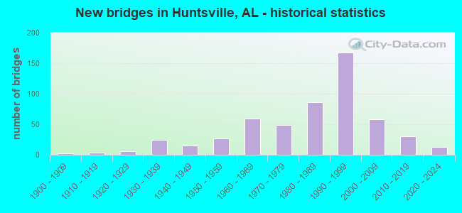
- New bridges - historical statistics
- 21900-1909
- 31910-1919
- 131920-1929
- 381930-1939
- 241940-1949
- 421950-1959
- 711960-1969
- 551970-1979
- 1011980-1989
- 1771990-1999
- 662000-2009
- 352010-2019
- 122020-2022
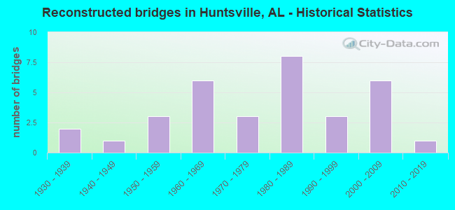
- Reconstructed bridges - Historical Statistics
- 21930-1939
- 11940-1949
- 31950-1959
- 61960-1969
- 31970-1979
- 81980-1989
- 31990-1999
- 62000-2009
- 12010-2019
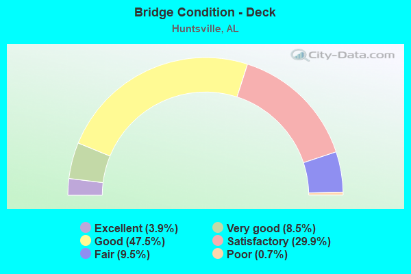
- Bridge Condition - Deck
- 3.9%Excellent
- 8.5%Very good
- 47.5%Good
- 29.9%Satisfactory
- 9.5%Fair
- 0.7%Poor
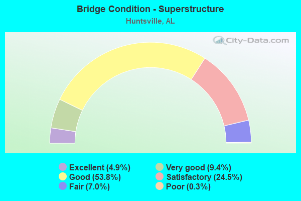
- Bridge Condition - Superstructure
- 4.9%Excellent
- 9.4%Very good
- 53.8%Good
- 24.5%Satisfactory
- 7.0%Fair
- 0.3%Poor
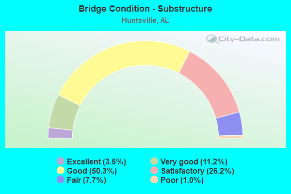
- Bridge Condition - Substructure
- 3.5%Excellent
- 11.2%Very good
- 50.3%Good
- 26.2%Satisfactory
- 7.7%Fair
- 1.0%Poor
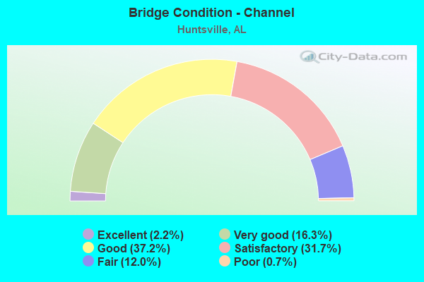
- Bridge Condition - Channel
- 2.2%Excellent
- 16.3%Very good
- 37.2%Good
- 31.7%Satisfactory
- 12.0%Fair
- 0.7%Poor
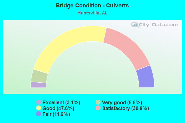
- Bridge Condition - Culverts
- 3.1%Excellent
- 6.6%Very good
- 47.6%Good
- 30.8%Satisfactory
- 11.9%Fair
Find on map >> Show street view
Structure Number: 1366, Location: 3 MI N JCT SR 36 & SR 53 (Lat: 34.566667, Lng: -86.575000), Route carried "on" structure: US 231, Year Built: 1985, Status: Open, Structure Length: 14.51m (47.60ft), Average Daily Traffic: 10,175 (year 2020), Truck Traffic: 3%, Average Future Daily Traffic: 13,226 (year 2033), Design Load: HS 20, Features Intersected: TN RIVER RELIEF, Facility Carried by Structure: SR 53
Minimum Vertical Clearance: 30+ m (98+ ft), Kilometerpoint: 492.025, Lanes on structure: 2, Owner: State Highway Agency, Approaching Roadway Width: 17.1m (56.1ft), Skew: 10 degrees, Material/Design: Prestressed concrete continuous, Design/Construction: Stringer/Multi-beam, Number Of Spans In Main Unit: 14, Length of Maximum Span: 10.4m (34.1ft), Curb-To-Curb Width: 17.1m (56.1ft), Out-to-Out Width: 18.0m (59.1ft)
Condition: Deck: Good, Superstructure: Good, Substructure: Good, Channel: Good, Operating Rating: 51.5 metric tons, Method Used To Determine Operating Rating: Load Factor (LF), Inventory Rating: 30.8 metric tons, Method Used To Determine Inventory Rating: Load Factor (LF), Structural Evaluation: Better than present minimum criteria, Deck Geometry: Superior to present desirable criteria, Waterway Adequacy: Equal to present desirable criteria, Approach Roadway Alignment: Better than present minimum criteria, Length Of Structure Improvement: 15.29m (50.16ft), Designated Inspection Frequency: Every 24 months, Inspection Date: August 2020, Bridge Improvement Cost: $6,187,000, Roadway Improvement Cost: $619,000, Total Project Cost: $6,806,000 ( Estimate for 2022), Deck Structure Type: Concrete Cast-file-Place
Find on map >> Show street view
Structure Number: 13661, Location: 3.3 M N JCT SR 36 & SR 53 (Lat: 34.568272, Lng: -86.573844), Route carried "on" structure: US 231, Year Built: 1985, Year Reconstructed: 2005, Status: Open, Structure Length: 13.47m (44.19ft), Average Daily Traffic: 10,175 (year 2020), Truck Traffic: 3%, Average Future Daily Traffic: 13,226 (year 2033), Design Load: HS 20, Features Intersected: TN RIVER RELIEF, Facility Carried by Structure: SR 53
Minimum Vertical Clearance: 30+ m (98+ ft), Kilometerpoint: 492.443, Lanes on structure: 2, Owner: State Highway Agency, Approaching Roadway Width: 17.1m (56.1ft), Skew: 10 degrees, Material/Design: Prestressed concrete continuous, Design/Construction: Stringer/Multi-beam, Number Of Spans In Main Unit: 13, Length of Maximum Span: 10.4m (34.1ft), Curb-To-Curb Width: 17.1m (56.1ft), Out-to-Out Width: 18.0m (59.1ft)
Condition: Deck: Good, Superstructure: Good, Substructure: Good, Channel: Good, Operating Rating: 51.5 metric tons, Method Used To Determine Operating Rating: Load Factor (LF), Inventory Rating: 30.8 metric tons, Method Used To Determine Inventory Rating: Load Factor (LF), Structural Evaluation: Better than present minimum criteria, Deck Geometry: Superior to present desirable criteria, Waterway Adequacy: Equal to present desirable criteria, Approach Roadway Alignment: Equal to present desirable criteria, Length Of Structure Improvement: 14.28m (46.85ft), Designated Inspection Frequency: Every 24 months, Inspection Date: August 2020, Bridge Improvement Cost: $5,777,000, Roadway Improvement Cost: $578,000, Total Project Cost: $6,355,000 ( Estimate for 2022), Deck Structure Type: Concrete Cast-file-Place
Find on map >> Show street view
Structure Number: 13699, Location: 2166 WINCHESTER RD (Lat: 34.792881, Lng: -86.589231), Route carried "on" structure: City street , Year Built: 1985, Status: Open, Structure Length: 1.34m (4.40ft), Average Daily Traffic: 11,500 (year 2019), Truck Traffic: 1%, Average Future Daily Traffic: 16,100 (year 2039), Design Load: H 10, Features Intersected: PINHOOK CREEK, Facility Carried by Structure: WINCHESTER RD
Minimum Vertical Clearance: 30+ m (98+ ft), Kilometerpoint: 0.010, Lanes on structure: 5, Owner: City or Municipal Highway Agency, Approaching Roadway Width: 15.8m (51.8ft), Skew: 3 degrees, Material/Design: Concrete, Design/Construction: Culvert, Number Of Spans In Main Unit: 4, Length of Maximum Span: 3.0m (9.8ft), Curb or Sidewalk Widths: Left: 1.5m (4.9ft), Right: 1.8m (5.9ft), Curb-To-Curb Width: 15.8m (51.8ft), Out-to-Out Width: 21.4m (70.2ft)
Condition: Channel: Good, Culverts: Good, Operating Rating: 39.8 metric tons, Method Used To Determine Operating Rating: Load Factor (LF), Inventory Rating: 23.9 metric tons, Method Used To Determine Inventory Rating: Load Factor (LF), Structural Evaluation: Somewhat better than minimum adequacy, Deck Geometry: High priority of replacement, Waterway Adequacy: Better than present minimum criteria, Approach Roadway Alignment: Better than present minimum criteria, Length Of Structure Improvement: 2.02m (6.63ft), Designated Inspection Frequency: Every 24 months, Inspection Date: September 2020, Bridge Improvement Cost: $861,000, Roadway Improvement Cost: $86,000, Total Project Cost: $947,000 ( Estimate for 2022)
Find on map >> Show street view
Structure Number: 13715, Location: 6.0 MI N SR 36 (Lat: 34.543306, Lng: -86.726472), Route carried "on" structure: County highway 377, Year Built: 1985, Status: Open, Structure Length: 6.92m (22.70ft), Average Daily Traffic: 130 (year 1984), Truck Traffic: 5%, Average Future Daily Traffic: 470 (year 2040), Design Load: HS 20, Features Intersected: COTACO CREEK, Facility Carried by Structure: SHARPSFORD RD
Minimum Vertical Clearance: 0.00m, Kilometerpoint: 0.010, Lanes on structure: 2, Owner: County Highway Agency, Approaching Roadway Width: 8.5m (27.9ft), Material/Design: Prestressed concrete, Design/Construction: Stringer/Multi-beam, Number Of Spans In Main Unit: 1, Number Of Approach Spans: 3, Length of Maximum Span: 30.5m (100.1ft), Curb-To-Curb Width: 7.3m (24.0ft), Out-to-Out Width: 8.2m (26.9ft)
Condition: Deck: Very good, Superstructure: Very good, Substructure: Good, Channel: Satisfactory, Operating Rating: 72.2 metric tons, Method Used To Determine Operating Rating: Load Factor (LF), Inventory Rating: 54.0 metric tons, Method Used To Determine Inventory Rating: Load Factor (LF), Structural Evaluation: Better than present minimum criteria, Deck Geometry: Somewhat better than minimum adequacy, Waterway Adequacy: Somewhat better than minimum adequacy, Approach Roadway Alignment: Better than present minimum criteria, Length Of Structure Improvement: 7.95m (26.08ft), Designated Inspection Frequency: Every 24 months, Underwater Inspection Frequency: Every 48 months, Inspection Date: December 2020, Underwater Inspection Date: June 2018, Bridge Improvement Cost: $1,418,000, Roadway Improvement Cost: $142,000, Total Project Cost: $1,560,000 ( Estimate for 2022), Deck Structure Type: Concrete Cast-file-Place
Find on map >> Show street view
Structure Number: 13872, Location: JCT US 431 * US 72 (Lat: 34.739831, Lng: -86.600086), Route carried "on" structure: US 231, Year Built: 1986, Status: Open, Structure Length: 10.42m (34.19ft), Average Daily Traffic: 57,417 (year 2019), Truck Traffic: 2%, Average Future Daily Traffic: 80,384 (year 2039), Design Load: HS 20, Features Intersected: SR 2
Minimum Vertical Clearance: 30+ m (98+ ft), Kilometerpoint: 539.457, Lanes on structure: 6, Lanes under structure: 4, Base Highway Network: Yes, Owner: State Highway Agency, Approaching Roadway Width: 14.3m (46.9ft), Skew: 21 degrees, Material/Design: Steel continuous, Design/Construction: Stringer/Multi-beam, Number Of Spans In Main Unit: 3, Length of Maximum Span: 42.7m (140.1ft), Curb-To-Curb Width: 13.0m (42.7ft), Out-to-Out Width: 27.6m (90.6ft)
Condition: Deck: Good, Superstructure: Good, Substructure: Good, Operating Rating: 42.3 metric tons, Method Used To Determine Operating Rating: Load Factor (LF), Inventory Rating: 25.3 metric tons, Method Used To Determine Inventory Rating: Load Factor (LF), Structural Evaluation: Equal to present minimum criteria, Deck Geometry: High priority of replacement, Underclear: Equal to present minimum criteria, Approach Roadway Alignment: Better than present minimum criteria, Length Of Structure Improvement: 11.33m (37.17ft), Designated Inspection Frequency: Every 24 months, Inspection Date: April 2021, Bridge Improvement Cost: $6,995,000, Roadway Improvement Cost: $700,000, Total Project Cost: $7,695,000 ( Estimate for 2022), Deck Structure Type: Concrete Cast-file-Place
Find on map >> Show street view
Structure Number: 13955, Location: .5 MI W HWY 231 SOUTH (Lat: 34.675000, Lng: -86.578333), Route carried "on" structure: City street , Year Built: 1986, Status: Open, Structure Length: 0.82m (2.69ft), Average Daily Traffic: 3,065 (year 2017), Truck Traffic: 30%, Average Future Daily Traffic: 4,291 (year 2037), Design Load: H 20, Features Intersected: CREEK, Facility Carried by Structure: VERMONT RD
Minimum Vertical Clearance: 30+ m (98+ ft), Kilometerpoint: 0.010, Lanes on structure: 2, Owner: City or Municipal Highway Agency, Approaching Roadway Width: 7.6m (24.9ft), Skew: 1 degrees, Material/Design: Concrete, Design/Construction: Culvert, Number Of Spans In Main Unit: 3, Length of Maximum Span: 2.7m (8.9ft), Curb-To-Curb Width: 7.6m (24.9ft), Out-to-Out Width: 7.6m (24.9ft)
Condition: Channel: Good, Culverts: Satisfactory, Operating Rating: 88.9 metric tons, Method Used To Determine Operating Rating: Load Factor (LF), Inventory Rating: 57.7 metric tons, Method Used To Determine Inventory Rating: Load Factor (LF), Structural Evaluation: Equal to present minimum criteria, Deck Geometry: High priority of replacement, Waterway Adequacy: Better than present minimum criteria, Approach Roadway Alignment: Better than present minimum criteria, Length Of Structure Improvement: 1.48m (4.86ft), Designated Inspection Frequency: Every 24 months, Inspection Date: March 2020, Bridge Improvement Cost: $341,000, Roadway Improvement Cost: $34,000, Total Project Cost: $375,000 ( Estimate for 2022), Wearing Surface/Protective System: Wearing Surface: Bituminous
Find on map >> Show street view
Structure Number: 14018, Location: .2 MI N OF US 72 W. (Lat: 34.753333, Lng: -86.691667), Route carried "on" structure: City street , Year Built: 1986, Status: Open, Structure Length: 3.79m (12.43ft), Average Daily Traffic: 9,200 (year 2019), Truck Traffic: 1%, Average Future Daily Traffic: 12,880 (year 2039), Design Load: HS 20, Features Intersected: INDIAN CREEK, Facility Carried by Structure: PROVIDENCE MAIN
Minimum Vertical Clearance: 30+ m (98+ ft), Kilometerpoint: 0.010, Lanes on structure: 4, Owner: City or Municipal Highway Agency, Approaching Roadway Width: 15.8m (51.8ft), Material/Design: Prestressed concrete continuous, Design/Construction: Stringer/Multi-beam, Number Of Spans In Main Unit: 3, Length of Maximum Span: 12.6m (41.3ft), Curb or Sidewalk Widths: Left: 1.5m (4.9ft), Right: 1.5m (4.9ft), Curb-To-Curb Width: 18.4m (60.4ft), Out-to-Out Width: 22.0m (72.2ft)
Condition: Deck: Good, Superstructure: Good, Substructure: Good, Channel: Satisfactory, Operating Rating: 49.0 metric tons, Method Used To Determine Operating Rating: Load Factor (LF), Inventory Rating: 29.3 metric tons, Method Used To Determine Inventory Rating: Load Factor (LF), Structural Evaluation: Better than present minimum criteria, Deck Geometry: Somewhat better than minimum adequacy, Waterway Adequacy: Equal to present minimum criteria, Approach Roadway Alignment: Better than present minimum criteria, Length Of Structure Improvement: 4.73m (15.52ft), Designated Inspection Frequency: Every 24 months, Inspection Date: April 2021, Bridge Improvement Cost: $2,335,000, Roadway Improvement Cost: $234,000, Total Project Cost: $2,569,000 ( Estimate for 2022), Deck Structure Type: Concrete Cast-file-Place
Find on map >> Show street view
Structure Number: 14019, Location: 1.9 MI W OF CO LINE RD (Lat: 34.623333, Lng: -86.755000), Route carried "on" structure: City street , Year Built: 1986, Status: Open, Structure Length: 1.58m (5.18ft), Average Daily Traffic: 9,600 (year 2020), Truck Traffic: 5%, Average Future Daily Traffic: 13,300 (year 2035), Design Load: HS 20, Features Intersected: STREAM, Facility Carried by Structure: BOEING ROAD
Minimum Vertical Clearance: 30+ m (98+ ft), Kilometerpoint: 0.010, Lanes on structure: 4, Owner: City or Municipal Highway Agency, Approaching Roadway Width: 14.3m (46.9ft), Skew: 13 degrees, Material/Design: Concrete, Design/Construction: Culvert, Number Of Spans In Main Unit: 6, Length of Maximum Span: 2.4m (7.9ft)
Condition: Channel: Good, Culverts: Good, Operating Rating: 88.9 metric tons, Method Used To Determine Operating Rating: Load Factor (LF), Inventory Rating: 64.2 metric tons, Method Used To Determine Inventory Rating: Load Factor (LF), Structural Evaluation: Better than present minimum criteria, Waterway Adequacy: Better than present minimum criteria, Approach Roadway Alignment: Better than present minimum criteria, Length Of Structure Improvement: 2.26m (7.41ft), Designated Inspection Frequency: Every 24 months, Inspection Date: January 2021, Bridge Improvement Cost: $1,672,000, Roadway Improvement Cost: $167,000, Total Project Cost: $1,839,000 ( Estimate for 2022)
Find on map >> Show street view
Structure Number: 14021, Location: 1.5 MI S SR20 (Lat: 34.656133, Lng: -86.754786), Route carried "on" structure: City street , Year Built: 1986, Status: Open, Structure Length: 5.18m (16.99ft), Average Daily Traffic: 22,000 (year 2015), Truck Traffic: 3%, Average Future Daily Traffic: 30,800 (year 2035), Design Load: HS 20, Features Intersected: E CHANNEL BRADFORD CRK, Facility Carried by Structure: WALL TRIANA RD
Minimum Vertical Clearance: 30+ m (98+ ft), Kilometerpoint: 0.010, Lanes on structure: 5, Owner: City or Municipal Highway Agency, Approaching Roadway Width: 21.3m (69.9ft), Skew: 20 degrees, Material/Design: Prestressed concrete, Design/Construction: Stringer/Multi-beam, Number Of Spans In Main Unit: 5, Length of Maximum Span: 10.4m (34.1ft), Curb-To-Curb Width: 21.3m (69.9ft), Out-to-Out Width: 22.2m (72.8ft)
Condition: Deck: Good, Superstructure: Good, Substructure: Good, Channel: Satisfactory, Operating Rating: 43.3 metric tons, Method Used To Determine Operating Rating: Load Factor (LF), Inventory Rating: 25.9 metric tons, Method Used To Determine Inventory Rating: Load Factor (LF), Structural Evaluation: Equal to present minimum criteria, Deck Geometry: Somewhat better than minimum adequacy, Waterway Adequacy: Better than present minimum criteria, Approach Roadway Alignment: Equal to present minimum criteria, Length Of Structure Improvement: 6.20m (20.34ft), Designated Inspection Frequency: Every 24 months, Inspection Date: June 2020, Bridge Improvement Cost: $3,062,000, Roadway Improvement Cost: $306,000, Total Project Cost: $3,368,000 ( Estimate for 2022), Deck Structure Type: Concrete Cast-file-Place
Find on map >> Show street view
Structure Number: 14065, Location: 1.6 MI N US HWY 72W (Lat: 34.777428, Lng: -86.714133), Route carried "on" structure: County highway 88, Year Built: 1987, Status: Open, Structure Length: 0.94m (3.08ft), Average Daily Traffic: 5,500 (year 1992), Truck Traffic: 1%, Average Future Daily Traffic: 7,005 (year 2040), Design Load: HS 20, Features Intersected: NICHOLS SPR. BRANCH, Facility Carried by Structure: JEFF RD
Minimum Vertical Clearance: 30+ m (98+ ft), Kilometerpoint: 0.010, Lanes on structure: 2, Owner: County Highway Agency, Approaching Roadway Width: 10.4m (34.1ft), Skew: 1 degrees, Material/Design: Concrete, Design/Construction: Culvert, Number Of Spans In Main Unit: 2, Length of Maximum Span: 4.3m (14.1ft), Curb-To-Curb Width: 13.4m (44.0ft), Out-to-Out Width: 14.0m (45.9ft)
Condition: Channel: Satisfactory, Culverts: Good, Operating Rating: 78.7 metric tons, Method Used To Determine Operating Rating: Load Factor (LF), Inventory Rating: 47.3 metric tons, Method Used To Determine Inventory Rating: Load Factor (LF), Structural Evaluation: Better than present minimum criteria, Deck Geometry: Equal to present minimum criteria, Waterway Adequacy: Better than present minimum criteria, Approach Roadway Alignment: Better than present minimum criteria, Length Of Structure Improvement: 1.61m (5.28ft), Designated Inspection Frequency: Every 24 months, Inspection Date: November 2020, Bridge Improvement Cost: $464,000, Roadway Improvement Cost: $46,000, Total Project Cost: $510,000 ( Estimate for 2022)
Find on map >> Show street view
Structure Number: 14076, Location: 1.0 MI NW CO RD 1322 (Lat: 34.780944, Lng: -86.492472), Route carried "on" structure: City street 424, Year Built: 1943, Year Reconstructed: 1987, Status: Open, Structure Length: 0.98m (3.22ft), Average Daily Traffic: 1,800 (year 2017), Truck Traffic: 1%, Average Future Daily Traffic: 2,520 (year 2037), Design Load: HS 20, Features Intersected: JORDAN CREEK, Facility Carried by Structure: JORDAN RD (CITY)
Minimum Vertical Clearance: 30+ m (98+ ft), Kilometerpoint: 0.010, Lanes on structure: 2, Owner: City or Municipal Highway Agency, Approaching Roadway Width: 10.4m (34.1ft), Material/Design: Concrete, Design/Construction: Culvert, Number Of Spans In Main Unit: 3, Length of Maximum Span: 3.0m (9.8ft), Curb-To-Curb Width: 12.2m (40.0ft), Out-to-Out Width: 13.7m (44.9ft)
Condition: Channel: Fair, Culverts: Satisfactory, Operating Rating: 77.1 metric tons, Method Used To Determine Operating Rating: Load Factor (LF), Inventory Rating: 46.3 metric tons, Method Used To Determine Inventory Rating: Load Factor (LF), Structural Evaluation: Equal to present minimum criteria, Deck Geometry: Better than present minimum criteria, Waterway Adequacy: Meets minimum limits, Approach Roadway Alignment: Equal to present minimum criteria, Length Of Structure Improvement: 1.65m (5.41ft), Designated Inspection Frequency: Every 24 months, Inspection Date: November 2020, Bridge Improvement Cost: $420,000, Roadway Improvement Cost: $42,000, Total Project Cost: $462,000 ( Estimate for 2022)
Find on map >> Show street view
Structure Number: 1411, Location: 2.5 MI E JCT I 565 & I 65 (Lat: 34.631806, Lng: -86.867417), Route carried "on" structure: ServiceInterstate 565, Year Built: 1965, Year Reconstructed: 1987, Status: Open, Structure Length: 16.86m (55.31ft), Average Daily Traffic: 429 (year 2021), Truck Traffic: 2%, Average Future Daily Traffic: 517 (year 2028), Design Load: HS 20, Features Intersected: LIMESTONE CREEK
Minimum Vertical Clearance: 30+ m (98+ ft), Kilometerpoint: 3.285, Lanes on structure: 2, Owner: State Highway Agency, Approaching Roadway Width: 9.8m (32.2ft), Skew: 10 degrees, Material/Design: Prestressed concrete, Design/Construction: Stringer/Multi-beam, Number Of Spans In Main Unit: 3, Number Of Approach Spans: 10, Length of Maximum Span: 20.7m (67.9ft), Curb-To-Curb Width: 8.5m (27.9ft), Out-to-Out Width: 10.1m (33.1ft)
Condition: Deck: Satisfactory, Superstructure: Satisfactory, Substructure: Satisfactory, Channel: Good, Operating Rating: 44.2 metric tons, Method Used To Determine Operating Rating: Load Factor (LF), Inventory Rating: 26.5 metric tons, Method Used To Determine Inventory Rating: Load Factor (LF), Structural Evaluation: Equal to present minimum criteria, Deck Geometry: Somewhat better than minimum adequacy, Waterway Adequacy: Equal to present minimum criteria, Approach Roadway Alignment: Better than present minimum criteria, Length Of Structure Improvement: 17.59m (57.71ft), Designated Inspection Frequency: Every 24 months, Inspection Date: Febuary 2021, Bridge Improvement Cost: $3,979,000, Roadway Improvement Cost: $398,000, Total Project Cost: $4,377,000 ( Estimate for 2022), Deck Structure Type: Concrete Cast-file-Place
Find on map >> Show street view
Structure Number: 14112, Location: 2.9 MI E JCT I 565 & I 65 (Lat: 34.634500, Lng: -86.860333), Route carried "on" structure: ServiceInterstate 565, Year Built: 1965, Year Reconstructed: 1987, Status: Open, Structure Length: 4.21m (13.81ft), Average Daily Traffic: 646 (year 2019), Truck Traffic: 2%, Average Future Daily Traffic: 1,089 (year 2035), Design Load: HS 20, Features Intersected: LIMESTONE SLOUGH
Minimum Vertical Clearance: 30+ m (98+ ft), Kilometerpoint: 4.019, Lanes on structure: 2, Owner: State Highway Agency, Approaching Roadway Width: 9.8m (32.2ft), Skew: 10 degrees, Material/Design: Concrete, Design/Construction: Tee Beam, Number Of Spans In Main Unit: 4, Length of Maximum Span: 10.4m (34.1ft), Curb-To-Curb Width: 8.5m (27.9ft), Out-to-Out Width: 9.5m (31.2ft)
Condition: Deck: Satisfactory, Superstructure: Good, Substructure: Good, Channel: Very good, Operating Rating: 43.5 metric tons, Method Used To Determine Operating Rating: Load Factor (LF), Inventory Rating: 26.1 metric tons, Method Used To Determine Inventory Rating: Load Factor (LF), Structural Evaluation: Equal to present minimum criteria, Deck Geometry: Somewhat better than minimum adequacy, Waterway Adequacy: Equal to present desirable criteria, Approach Roadway Alignment: Better than present minimum criteria, Length Of Structure Improvement: 5.18m (16.99ft), Designated Inspection Frequency: Every 24 months, Inspection Date: Febuary 2021, Bridge Improvement Cost: $1,101,000, Roadway Improvement Cost: $110,000, Total Project Cost: $1,211,000 ( Estimate for 2022), Deck Structure Type: Concrete Cast-file-Place
Find on map >> Show street view
Structure Number: 14141, Location: 2.5 MI E JCT I 565 & I 65 (Lat: 34.632583, Lng: -86.867500), Route carried "on" structure: ServiceInterstate 565, Year Built: 1987, Status: Open, Structure Length: 17.43m (57.19ft), Average Daily Traffic: 550 (year 2021), Truck Traffic: 2%, Average Future Daily Traffic: 616 (year 2028), Design Load: HS 20, Features Intersected: LIMESTONE CREEK
Minimum Vertical Clearance: 30+ m (98+ ft), Kilometerpoint: 3.285, Lanes on structure: 2, Owner: State Highway Agency, Approaching Roadway Width: 9.8m (32.2ft), Skew: 10 degrees, Material/Design: Prestressed concrete, Design/Construction: Stringer/Multi-beam, Number Of Spans In Main Unit: 1, Number Of Approach Spans: 12, Length of Maximum Span: 24.1m (79.1ft), Curb-To-Curb Width: 8.5m (27.9ft), Out-to-Out Width: 9.4m (30.8ft)
Condition: Deck: Satisfactory, Superstructure: Good, Substructure: Good, Channel: Good, Operating Rating: 60.9 metric tons, Method Used To Determine Operating Rating: Load Factor (LF), Inventory Rating: 38.9 metric tons, Method Used To Determine Inventory Rating: Load Factor (LF), Structural Evaluation: Better than present minimum criteria, Deck Geometry: Somewhat better than minimum adequacy, Waterway Adequacy: Equal to present minimum criteria, Approach Roadway Alignment: Equal to present desirable criteria, Length Of Structure Improvement: 18.14m (59.51ft), Designated Inspection Frequency: Every 24 months, Inspection Date: Febuary 2021, Bridge Improvement Cost: $3,731,000, Roadway Improvement Cost: $373,000, Total Project Cost: $4,104,000 ( Estimate for 2022), Deck Structure Type: Concrete Cast-file-Place
Find on map >> Show street view
Structure Number: 14142, Location: 2.5 MI E JCT I 565 & I 65 (Lat: 34.632889, Lng: -86.865861), Route carried "on" structure: Interstate 565, Year Built: 1987, Status: Open, Structure Length: 17.43m (57.19ft), Average Daily Traffic: 25,775 (year 2021), Truck Traffic: 10%, Average Future Daily Traffic: 34,104 (year 2033), Design Load: HS 20, Features Intersected: LIMESTONE CREEK
Minimum Vertical Clearance: 30+ m (98+ ft), Kilometerpoint: 3.285, Lanes on structure: 2, Base Highway Network: Yes, Owner: State Highway Agency, Approaching Roadway Width: 12.5m (41.0ft), Skew: 10 degrees, Material/Design: Prestressed concrete, Design/Construction: Stringer/Multi-beam, Number Of Spans In Main Unit: 1, Number Of Approach Spans: 12, Length of Maximum Span: 24.4m (80.1ft), Curb-To-Curb Width: 12.1m (39.7ft), Out-to-Out Width: 13.0m (42.7ft)
Condition: Deck: Satisfactory, Superstructure: Good, Substructure: Satisfactory, Channel: Good, Operating Rating: 54.2 metric tons, Method Used To Determine Operating Rating: Load Factor (LF), Inventory Rating: 31.1 metric tons, Method Used To Determine Inventory Rating: Load Factor (LF), Structural Evaluation: Equal to present minimum criteria, Deck Geometry: Equal to present minimum criteria, Waterway Adequacy: Better than present minimum criteria, Approach Roadway Alignment: Equal to present desirable criteria, Length Of Structure Improvement: 18.14m (59.51ft), Designated Inspection Frequency: Every 24 months, Inspection Date: Febuary 2021, Bridge Improvement Cost: $5,223,000, Roadway Improvement Cost: $522,000, Total Project Cost: $5,745,000 ( Estimate for 2022), Deck Structure Type: Concrete Cast-file-Place
Find on map >> Show street view
Structure Number: 14143, Location: 2.5 MI E JCT I 65 & I 565 (Lat: 34.632028, Lng: -86.867500), Route carried "on" structure: Interstate 565, Year Built: 1987, Status: Open, Structure Length: 17.43m (57.19ft), Average Daily Traffic: 25,775 (year 2019), Truck Traffic: 10%, Average Future Daily Traffic: 34,104 (year 2033), Design Load: HS 20, Features Intersected: LIMESTONE CREEK
Minimum Vertical Clearance: 30+ m (98+ ft), Kilometerpoint: 3.285, Lanes on structure: 2, Base Highway Network: Yes, Owner: State Highway Agency, Approaching Roadway Width: 12.5m (41.0ft), Skew: 10 degrees, Material/Design: Prestressed concrete, Design/Construction: Stringer/Multi-beam, Number Of Spans In Main Unit: 1, Number Of Approach Spans: 12, Length of Maximum Span: 24.4m (80.1ft), Curb-To-Curb Width: 12.2m (40.0ft), Out-to-Out Width: 13.0m (42.7ft)
Condition: Deck: Satisfactory, Superstructure: Good, Substructure: Satisfactory, Channel: Very good, Operating Rating: 54.2 metric tons, Method Used To Determine Operating Rating: Load Factor (LF), Inventory Rating: 31.1 metric tons, Method Used To Determine Inventory Rating: Load Factor (LF), Structural Evaluation: Equal to present minimum criteria, Deck Geometry: Better than present minimum criteria, Waterway Adequacy: Equal to present minimum criteria, Approach Roadway Alignment: Better than present minimum criteria, Length Of Structure Improvement: 18.14m (59.51ft), Designated Inspection Frequency: Every 24 months, Inspection Date: Febuary 2021, Bridge Improvement Cost: $5,223,000, Roadway Improvement Cost: $522,000, Total Project Cost: $5,745,000 ( Estimate for 2022), Deck Structure Type: Concrete Cast-file-Place
Find on map >> Show street view
Structure Number: 14144, Location: 2.7 MI E JCT I 565 & I 65 (Lat: 34.634028, Lng: -86.863639), Route carried "on" structure: ServiceInterstate 565, Year Built: 1987, Status: Open, Structure Length: 7.50m (24.61ft), Average Daily Traffic: 665 (year 2021), Truck Traffic: 2%, Average Future Daily Traffic: 759 (year 2031), Design Load: HS 20, Features Intersected: LIMESTONE CREEK RELIEF
Minimum Vertical Clearance: 30+ m (98+ ft), Kilometerpoint: 3.697, Lanes on structure: 2, Owner: State Highway Agency, Approaching Roadway Width: 9.8m (32.2ft), Skew: 10 degrees, Material/Design: Prestressed concrete continuous, Design/Construction: Stringer/Multi-beam, Number Of Spans In Main Unit: 6, Length of Maximum Span: 12.5m (41.0ft), Curb-To-Curb Width: 8.5m (27.9ft), Out-to-Out Width: 9.4m (30.8ft)
Condition: Deck: Satisfactory, Superstructure: Good, Substructure: Very good, Channel: Very good, Operating Rating: 54.9 metric tons, Method Used To Determine Operating Rating: Load Factor (LF), Inventory Rating: 33.1 metric tons, Method Used To Determine Inventory Rating: Load Factor (LF), Structural Evaluation: Better than present minimum criteria, Deck Geometry: Somewhat better than minimum adequacy, Waterway Adequacy: Better than present minimum criteria, Approach Roadway Alignment: Better than present minimum criteria, Length Of Structure Improvement: 8.52m (27.95ft), Designated Inspection Frequency: Every 24 months, Inspection Date: Febuary 2021, Bridge Improvement Cost: $1,753,000, Roadway Improvement Cost: $175,000, Total Project Cost: $1,928,000 ( Estimate for 2022), Deck Structure Type: Concrete Cast-file-Place
Find on map >> Show street view
Structure Number: 14145, Location: 2.7 MI E JCT I 565 & I 65 (Lat: 34.634056, Lng: -86.862778), Route carried "on" structure: Interstate 565, Year Built: 1987, Status: Open, Structure Length: 7.50m (24.61ft), Average Daily Traffic: 25,775 (year 2021), Truck Traffic: 10%, Average Future Daily Traffic: 34,104 (year 2033), Design Load: HS 20, Features Intersected: LIMESTONE CREEK RELIEF
Minimum Vertical Clearance: 30+ m (98+ ft), Kilometerpoint: 3.697, Lanes on structure: 2, Base Highway Network: Yes, Owner: State Highway Agency, Approaching Roadway Width: 12.2m (40.0ft), Skew: 10 degrees, Material/Design: Prestressed concrete continuous, Design/Construction: Stringer/Multi-beam, Number Of Spans In Main Unit: 6, Length of Maximum Span: 12.5m (41.0ft), Curb-To-Curb Width: 12.2m (40.0ft), Out-to-Out Width: 13.1m (43.0ft)
Condition: Deck: Good, Superstructure: Good, Substructure: Good, Channel: Very good, Operating Rating: 45.5 metric tons, Method Used To Determine Operating Rating: Load Factor (LF), Inventory Rating: 28.8 metric tons, Method Used To Determine Inventory Rating: Load Factor (LF), Structural Evaluation: Better than present minimum criteria, Deck Geometry: Better than present minimum criteria, Waterway Adequacy: Better than present minimum criteria, Approach Roadway Alignment: Better than present minimum criteria, Length Of Structure Improvement: 8.52m (27.95ft), Designated Inspection Frequency: Every 24 months, Inspection Date: Febuary 2021, Bridge Improvement Cost: $2,513,000, Roadway Improvement Cost: $251,000, Total Project Cost: $2,764,000 ( Estimate for 2022), Deck Structure Type: Concrete Cast-file-Place
Find on map >> Show street view
Structure Number: 14146, Location: 2.7 MI E JCT I 565 & I 65 (Lat: 34.633528, Lng: -86.863750), Route carried "on" structure: Interstate 565, Year Built: 1987, Status: Open, Structure Length: 7.50m (24.61ft), Average Daily Traffic: 25,775 (year 2021), Truck Traffic: 10%, Average Future Daily Traffic: 34,104 (year 2033), Design Load: HS 20, Features Intersected: LIMESTONE CREEK RELIEF
Minimum Vertical Clearance: 30+ m (98+ ft), Kilometerpoint: 3.697, Lanes on structure: 2, Base Highway Network: Yes, Owner: State Highway Agency, Approaching Roadway Width: 12.2m (40.0ft), Skew: 10 degrees, Material/Design: Prestressed concrete continuous, Design/Construction: Stringer/Multi-beam, Number Of Spans In Main Unit: 6, Length of Maximum Span: 12.5m (41.0ft), Curb-To-Curb Width: 12.2m (40.0ft), Out-to-Out Width: 13.0m (42.7ft)
Condition: Deck: Good, Superstructure: Good, Substructure: Good, Channel: Very good, Operating Rating: 45.5 metric tons, Method Used To Determine Operating Rating: Load Factor (LF), Inventory Rating: 28.8 metric tons, Method Used To Determine Inventory Rating: Load Factor (LF), Structural Evaluation: Better than present minimum criteria, Deck Geometry: Better than present minimum criteria, Waterway Adequacy: Better than present minimum criteria, Approach Roadway Alignment: Better than present minimum criteria, Length Of Structure Improvement: 8.52m (27.95ft), Designated Inspection Frequency: Every 24 months, Inspection Date: Febuary 2021, Bridge Improvement Cost: $2,455,000, Roadway Improvement Cost: $246,000, Total Project Cost: $2,701,000 ( Estimate for 2022), Deck Structure Type: Concrete Cast-file-Place
Find on map >> Show street view
Structure Number: 14147, Location: 2.9 MI E JCT I 565 & I 65 (Lat: 34.635222, Lng: -86.860389), Route carried "on" structure: ServiceInterstate 565, Year Built: 1987, Status: Open, Structure Length: 5.00m (16.40ft), Average Daily Traffic: 646 (year 2021), Truck Traffic: 2%, Average Future Daily Traffic: 1,089 (year 2035), Design Load: HS 20, Features Intersected: LIMESTONE SLOUGH
Minimum Vertical Clearance: 30+ m (98+ ft), Kilometerpoint: 4.019, Lanes on structure: 2, Owner: State Highway Agency, Approaching Roadway Width: 9.8m (32.2ft), Skew: 10 degrees, Material/Design: Prestressed concrete continuous, Design/Construction: Stringer/Multi-beam, Number Of Spans In Main Unit: 4, Length of Maximum Span: 12.5m (41.0ft), Curb-To-Curb Width: 8.5m (27.9ft), Out-to-Out Width: 9.4m (30.8ft)
Condition: Deck: Satisfactory, Superstructure: Good, Substructure: Very good, Channel: Very good, Operating Rating: 58.0 metric tons, Method Used To Determine Operating Rating: Load Factor (LF), Inventory Rating: 35.5 metric tons, Method Used To Determine Inventory Rating: Load Factor (LF), Structural Evaluation: Better than present minimum criteria, Deck Geometry: Somewhat better than minimum adequacy, Waterway Adequacy: Better than present minimum criteria, Approach Roadway Alignment: Better than present minimum criteria, Length Of Structure Improvement: 6.02m (19.75ft), Designated Inspection Frequency: Every 24 months, Inspection Date: Febuary 2021, Bridge Improvement Cost: $1,237,000, Roadway Improvement Cost: $124,000, Total Project Cost: $1,361,000 ( Estimate for 2022), Deck Structure Type: Concrete Cast-file-Place
Find on map >> Show street view
Structure Number: 14148, Location: 2.9 MI E JCT I 565 & I 65 (Lat: 34.635111, Lng: -86.859806), Route carried "on" structure: Interstate 565, Year Built: 1987, Status: Open, Structure Length: 5.00m (16.40ft), Average Daily Traffic: 25,775 (year 2021), Truck Traffic: 10%, Average Future Daily Traffic: 34,104 (year 2033), Design Load: HS 20, Features Intersected: LIMESTONE SLOUGH
Minimum Vertical Clearance: 30+ m (98+ ft), Kilometerpoint: 4.019, Lanes on structure: 2, Owner: State Highway Agency, Approaching Roadway Width: 12.2m (40.0ft), Skew: 10 degrees, Material/Design: Prestressed concrete continuous, Design/Construction: Stringer/Multi-beam, Number Of Spans In Main Unit: 4, Length of Maximum Span: 12.5m (41.0ft), Curb-To-Curb Width: 12.2m (40.0ft), Out-to-Out Width: 13.0m (42.7ft)
Condition: Deck: Satisfactory, Superstructure: Good, Substructure: Good, Channel: Very good, Operating Rating: 53.9 metric tons, Method Used To Determine Operating Rating: Load Factor (LF), Inventory Rating: 31.3 metric tons, Method Used To Determine Inventory Rating: Load Factor (LF), Structural Evaluation: Better than present minimum criteria, Deck Geometry: Better than present minimum criteria, Waterway Adequacy: Better than present minimum criteria, Approach Roadway Alignment: Better than present minimum criteria, Length Of Structure Improvement: 6.02m (19.75ft), Designated Inspection Frequency: Every 24 months, Inspection Date: Febuary 2021, Bridge Improvement Cost: $1,732,000, Roadway Improvement Cost: $173,000, Total Project Cost: $1,905,000 ( Estimate for 2022), Deck Structure Type: Concrete Cast-file-Place
Find on map >> Show street view
Structure Number: 14149, Location: 2.9 MI E JCT I 565 & I 65 (Lat: 34.634833, Lng: -86.860111), Route carried "on" structure: Interstate 565, Year Built: 1987, Status: Open, Structure Length: 5.00m (16.40ft), Average Daily Traffic: 25,775 (year 2021), Truck Traffic: 10%, Average Future Daily Traffic: 34,104 (year 2033), Design Load: HS 20, Features Intersected: LIMESTONE SLOUGH
Minimum Vertical Clearance: 30+ m (98+ ft), Kilometerpoint: 4.019, Lanes on structure: 2, Owner: State Highway Agency, Approaching Roadway Width: 12.2m (40.0ft), Skew: 10 degrees, Material/Design: Prestressed concrete continuous, Design/Construction: Stringer/Multi-beam, Number Of Spans In Main Unit: 4, Length of Maximum Span: 12.5m (41.0ft), Curb-To-Curb Width: 12.2m (40.0ft), Out-to-Out Width: 13.1m (43.0ft)
Condition: Deck: Good, Superstructure: Good, Substructure: Good, Channel: Very good, Operating Rating: 53.9 metric tons, Method Used To Determine Operating Rating: Load Factor (LF), Inventory Rating: 31.3 metric tons, Method Used To Determine Inventory Rating: Load Factor (LF), Structural Evaluation: Better than present minimum criteria, Deck Geometry: Better than present minimum criteria, Waterway Adequacy: Equal to present desirable criteria, Approach Roadway Alignment: Better than present minimum criteria, Length Of Structure Improvement: 6.02m (19.75ft), Designated Inspection Frequency: Every 24 months, Inspection Date: Febuary 2021, Bridge Improvement Cost: $1,774,000, Roadway Improvement Cost: $177,000, Total Project Cost: $1,951,000 ( Estimate for 2022), Deck Structure Type: Concrete Cast-file-Place
Find on map >> Show street view
Structure Number: 1415, Location: 4 MI E JCT I 65 & I 565 (Lat: 34.640683, Lng: -86.843853), Route carried "on" structure: County highway , Year Built: 1987, Status: Open, Structure Length: 9.14m (29.99ft), Average Daily Traffic: 781 (year 2020), Truck Traffic: 5%, Average Future Daily Traffic: 1,276 (year 2031), Design Load: HS 20, Features Intersected: I 565, Facility Carried by Structure: GREENBRIER ROAD
Minimum Vertical Clearance: 30+ m (98+ ft), Kilometerpoint: 5.641, Lanes on structure: 5, Lanes under structure: 4, Owner: State Highway Agency, Approaching Roadway Width: 16.5m (54.1ft), Skew: 2 degrees, Material/Design: Steel continuous, Design/Construction: Stringer/Multi-beam, Number Of Spans In Main Unit: 3, Length of Maximum Span: 48.2m (158.1ft), Curb-To-Curb Width: 16.5m (54.1ft), Out-to-Out Width: 17.3m (56.8ft)
Condition: Deck: Good, Superstructure: Very good, Substructure: Very good, Operating Rating: 72.4 metric tons, Method Used To Determine Operating Rating: Load Factor (LF), Inventory Rating: 43.4 metric tons, Method Used To Determine Inventory Rating: Load Factor (LF), Structural Evaluation: Equal to present desirable criteria, Deck Geometry: High priority of replacement, Underclear: Superior to present desirable criteria, Approach Roadway Alignment: Better than present minimum criteria, Length Of Structure Improvement: 10.11m (33.17ft), Designated Inspection Frequency: Every 24 months, Inspection Date: March 2020, Bridge Improvement Cost: $3,881,000, Roadway Improvement Cost: $388,000, Total Project Cost: $4,269,000 ( Estimate for 2022), Deck Structure Type: Concrete Cast-file-Place
Find on map >> Show street view
Structure Number: 14151, Location: 4.8 M E JCT I 565 & I 65 (Lat: 34.649472, Lng: -86.822861), Route carried "on" structure: ServiceInterstate 565, Year Built: 1987, Status: Open, Structure Length: 3.75m (12.30ft), Average Daily Traffic: 486 (year 2021), Truck Traffic: 3%, Average Future Daily Traffic: 640 (year 2031), Design Load: HS 20, Features Intersected: BEAVER DAM CREEK
Minimum Vertical Clearance: 30+ m (98+ ft), Kilometerpoint: 7.792, Lanes on structure: 2, Base Highway Network: Yes, Owner: State Highway Agency, Approaching Roadway Width: 9.8m (32.2ft), Skew: 10 degrees, Material/Design: Prestressed concrete continuous, Design/Construction: Stringer/Multi-beam, Number Of Spans In Main Unit: 3, Length of Maximum Span: 12.5m (41.0ft), Curb-To-Curb Width: 8.5m (27.9ft), Out-to-Out Width: 9.4m (30.8ft)
Condition: Deck: Satisfactory, Superstructure: Good, Substructure: Good, Channel: Very good, Operating Rating: 54.6 metric tons, Method Used To Determine Operating Rating: Load Factor (LF), Inventory Rating: 33.2 metric tons, Method Used To Determine Inventory Rating: Load Factor (LF), Structural Evaluation: Better than present minimum criteria, Deck Geometry: Somewhat better than minimum adequacy, Waterway Adequacy: Better than present minimum criteria, Approach Roadway Alignment: Equal to present desirable criteria, Length Of Structure Improvement: 4.68m (15.35ft), Designated Inspection Frequency: Every 24 months, Underwater Inspection Frequency: Every 24 months, Inspection Date: Febuary 2021, Underwater Inspection Date: June 2020, Bridge Improvement Cost: $962,000, Roadway Improvement Cost: $96,000, Total Project Cost: $1,058,000 ( Estimate for 2022), Deck Structure Type: Concrete Cast-file-Place
Find on map >> Show street view
Structure Number: 14152, Location: 4.8 M E JCT I 565 & I 65 (Lat: 34.649167, Lng: -86.822500), Route carried "on" structure: Interstate 565, Year Built: 1987, Status: Open, Structure Length: 3.75m (12.30ft), Average Daily Traffic: 26,640 (year 2021), Truck Traffic: 10%, Average Future Daily Traffic: 35,249 (year 2033), Design Load: HS 20, Features Intersected: BEAVER DAM CREEK
Minimum Vertical Clearance: 30+ m (98+ ft), Kilometerpoint: 7.792, Lanes on structure: 2, Base Highway Network: Yes, Owner: State Highway Agency, Approaching Roadway Width: 12.2m (40.0ft), Skew: 10 degrees, Material/Design: Prestressed concrete continuous, Design/Construction: Stringer/Multi-beam, Number Of Spans In Main Unit: 3, Length of Maximum Span: 12.5m (41.0ft), Curb-To-Curb Width: 12.2m (40.0ft), Out-to-Out Width: 13.0m (42.7ft)
Condition: Deck: Good, Superstructure: Good, Substructure: Good, Channel: Very good, Operating Rating: 55.0 metric tons, Method Used To Determine Operating Rating: Load Factor (LF), Inventory Rating: 31.5 metric tons, Method Used To Determine Inventory Rating: Load Factor (LF), Structural Evaluation: Better than present minimum criteria, Deck Geometry: Better than present minimum criteria, Waterway Adequacy: Better than present minimum criteria, Approach Roadway Alignment: Better than present minimum criteria, Length Of Structure Improvement: 4.68m (15.35ft), Designated Inspection Frequency: Every 24 months, Underwater Inspection Frequency: Every 24 months, Inspection Date: Febuary 2021, Underwater Inspection Date: June 2020, Bridge Improvement Cost: $1,347,000, Roadway Improvement Cost: $135,000, Total Project Cost: $1,482,000 ( Estimate for 2022), Deck Structure Type: Concrete Cast-file-Place
Find on map >> Show street view
Structure Number: 14153, Location: 4.8 M E JCT I 565 & I 65 (Lat: 34.649028, Lng: -86.822611), Route carried "on" structure: Interstate 565, Year Built: 1987, Status: Open, Structure Length: 3.75m (12.30ft), Average Daily Traffic: 26,640 (year 2021), Truck Traffic: 10%, Average Future Daily Traffic: 35,249 (year 2033), Design Load: HS 20, Features Intersected: BEAVER DAM CREEK
Minimum Vertical Clearance: 30+ m (98+ ft), Kilometerpoint: 7.792, Lanes on structure: 2, Base Highway Network: Yes, Owner: State Highway Agency, Approaching Roadway Width: 12.2m (40.0ft), Skew: 10 degrees, Material/Design: Prestressed concrete continuous, Design/Construction: Stringer/Multi-beam, Number Of Spans In Main Unit: 3, Length of Maximum Span: 12.5m (41.0ft), Curb-To-Curb Width: 12.2m (40.0ft), Out-to-Out Width: 13.0m (42.7ft)
Condition: Deck: Good, Superstructure: Good, Substructure: Good, Channel: Very good, Operating Rating: 47.9 metric tons, Method Used To Determine Operating Rating: Load Factor (LF), Inventory Rating: 28.8 metric tons, Method Used To Determine Inventory Rating: Load Factor (LF), Structural Evaluation: Better than present minimum criteria, Deck Geometry: Better than present minimum criteria, Waterway Adequacy: Better than present minimum criteria, Approach Roadway Alignment: Better than present minimum criteria, Length Of Structure Improvement: 4.68m (15.35ft), Designated Inspection Frequency: Every 24 months, Underwater Inspection Frequency: Every 24 months, Inspection Date: Febuary 2021, Underwater Inspection Date: June 2020, Bridge Improvement Cost: $1,347,000, Roadway Improvement Cost: $135,000, Total Project Cost: $1,482,000 ( Estimate for 2022), Deck Structure Type: Concrete Cast-file-Place
Find on map >> Show street view
Structure Number: 14236, Location: 4200 OAKWOOD AVE (Lat: 34.748333, Lng: -86.630000), Route carried "on" structure: City street , Year Built: 1987, Status: Open, Structure Length: 1.04m (3.41ft), Average Daily Traffic: 12 (year 2019), Average Future Daily Traffic: 17 (year 2039), Features Intersected: DRY CREEK, Facility Carried by Structure: DRIVEWAY
Minimum Vertical Clearance: 30+ m (98+ ft), Kilometerpoint: 0.010, Lanes on structure: 1, Owner: City or Municipal Highway Agency, Approaching Roadway Width: 3.4m (11.2ft), Skew: 3 degrees, Material/Design: Steel continuous, Design/Construction: Stringer/Multi-beam, Number Of Spans In Main Unit: 2, Length of Maximum Span: 10.4m (34.1ft), Curb-To-Curb Width: 3.2m (10.5ft), Out-to-Out Width: 3.8m (12.5ft)
Condition: Deck: Good, Superstructure: Good, Substructure: Good, Channel: Very good, Operating Rating: 54.7 metric tons, Method Used To Determine Operating Rating: Load Factor (LF), Inventory Rating: 32.7 metric tons, Method Used To Determine Inventory Rating: Load Factor (LF), Structural Evaluation: Better than present minimum criteria, Deck Geometry: High priority of replacement, Waterway Adequacy: Better than present minimum criteria, Approach Roadway Alignment: Equal to present minimum criteria, Length Of Structure Improvement: 1.71m (5.61ft), Designated Inspection Frequency: Every 24 months, Inspection Date: September 2020, Bridge Improvement Cost: $141,000, Roadway Improvement Cost: $14,000, Total Project Cost: $155,000 ( Estimate for 2022), Deck Structure Type: Concrete Cast-file-Place
Find on map >> Show street view
Structure Number: 14248, Location: .1 MI E. OF US 31 SOUTH (Lat: 34.691667, Lng: -86.578333), Route carried "on" structure: City street , Year Built: 1987, Status: Open, Structure Length: 0.76m (2.49ft), Average Daily Traffic: 32,000 (year 2017), Truck Traffic: 1%, Average Future Daily Traffic: 44,800 (year 2037), Design Load: HS 15, Features Intersected: CREEK, Facility Carried by Structure: AIRPORT ROAD
Minimum Vertical Clearance: 30+ m (98+ ft), Kilometerpoint: 0.000, Lanes on structure: 5, Owner: City or Municipal Highway Agency, Approaching Roadway Width: 25.0m (82.0ft), Material/Design: Concrete, Design/Construction: Culvert, Number Of Spans In Main Unit: 2, Length of Maximum Span: 3.7m (12.1ft), Curb or Sidewalk Widths: Left: 1.5m (4.9ft), Right: 1.5m (4.9ft)
Condition: Channel: Satisfactory, Culverts: Good, Operating Rating: 87.9 metric tons, Method Used To Determine Operating Rating: Load Factor (LF), Inventory Rating: 52.7 metric tons, Method Used To Determine Inventory Rating: Load Factor (LF), Structural Evaluation: Better than present minimum criteria, Waterway Adequacy: Better than present minimum criteria, Approach Roadway Alignment: Better than present minimum criteria, Length Of Structure Improvement: 1.41m (4.63ft), Designated Inspection Frequency: Every 24 months, Inspection Date: July 2020, Bridge Improvement Cost: $829,000, Roadway Improvement Cost: $83,000, Total Project Cost: $912,000 ( Estimate for 2022)
Find on map >> Show street view
Structure Number: 14265, Location: .5 MI WEST OF RIDEOUT RD (Lat: 34.718333, Lng: -86.671667), Route carried "on" structure: City street , Year Built: 1987, Status: Open, Structure Length: 0.94m (3.08ft), Average Daily Traffic: 19,200 (year 2019), Truck Traffic: 1%, Average Future Daily Traffic: 26,880 (year 2039), Design Load: HS 20, Features Intersected: SHERWOOD BRANCH TRIB, Facility Carried by Structure: BRADFORD DRIVE
Minimum Vertical Clearance: 30+ m (98+ ft), Kilometerpoint: 0.010, Lanes on structure: 5, Owner: City or Municipal Highway Agency, Approaching Roadway Width: 35.0m (114.8ft), Skew: 23 degrees, Material/Design: Concrete, Design/Construction: Culvert, Number Of Spans In Main Unit: 3, Length of Maximum Span: 3.0m (9.8ft)
Condition: Channel: Very good, Culverts: Good, Operating Rating: 88.9 metric tons, Method Used To Determine Operating Rating: Load Factor (LF), Inventory Rating: 85.5 metric tons, Method Used To Determine Inventory Rating: Load Factor (LF), Structural Evaluation: Better than present minimum criteria, Waterway Adequacy: Better than present minimum criteria, Approach Roadway Alignment: Better than present minimum criteria, Length Of Structure Improvement: 1.61m (5.28ft), Designated Inspection Frequency: Every 24 months, Inspection Date: September 2020, Bridge Improvement Cost: $1,839,000, Roadway Improvement Cost: $184,000, Total Project Cost: $2,023,000 ( Estimate for 2022)
Find on map >> Show street view
Structure Number: 14266, Location: BRADFORD DR. A/SHERWOOD B (Lat: 34.718333, Lng: -86.666667), Route carried "on" structure: City street , Year Built: 1987, Status: Open, Structure Length: 1.52m (4.99ft), Average Daily Traffic: 15,200 (year 2019), Truck Traffic: 1%, Average Future Daily Traffic: 21,280 (year 2039), Design Load: HS 20, Features Intersected: SHERWOOD BRANCH, Facility Carried by Structure: BRADFORD DRIVE
Minimum Vertical Clearance: 30+ m (98+ ft), Kilometerpoint: 0.010, Lanes on structure: 6, Owner: City or Municipal Highway Agency, Approaching Roadway Width: 65.2m (213.9ft), Skew: 20 degrees, Material/Design: Concrete, Design/Construction: Culvert, Number Of Spans In Main Unit: 4, Length of Maximum Span: 3.7m (12.1ft)
Condition: Channel: Very good, Culverts: Good, Operating Rating: 75.8 metric tons, Method Used To Determine Operating Rating: Load Factor (LF), Inventory Rating: 45.4 metric tons, Method Used To Determine Inventory Rating: Load Factor (LF), Structural Evaluation: Better than present minimum criteria, Waterway Adequacy: Better than present minimum criteria, Approach Roadway Alignment: Better than present minimum criteria, Length Of Structure Improvement: 2.20m (7.22ft), Designated Inspection Frequency: Every 24 months, Inspection Date: September 2020, Bridge Improvement Cost: $2,719,000, Roadway Improvement Cost: $272,000, Total Project Cost: $2,991,000 ( Estimate for 2022)
Find on map >> Show street view
Structure Number: 14287, Location: DANESE LN AT ALDRIDGE TRI (Lat: 34.637361, Lng: -86.529611), Route carried "on" structure: City street , Year Built: 1987, Status: Open, Structure Length: 0.91m (2.99ft), Average Daily Traffic: 290 (year 2015), Truck Traffic: 1%, Average Future Daily Traffic: 406 (year 2035), Design Load: HS 15, Features Intersected: ALDRIDGE TRIB., Facility Carried by Structure: DANESE LANE
Minimum Vertical Clearance: 30+ m (98+ ft), Kilometerpoint: 0.010, Lanes on structure: 2, Owner: City or Municipal Highway Agency, Approaching Roadway Width: 9.1m (29.9ft), Skew: 1 degrees, Material/Design: Aluminum, Iron, Design/Construction: Culvert, Number Of Spans In Main Unit: 2, Length of Maximum Span: 4.6m (15.1ft), Curb-To-Curb Width: 9.1m (29.9ft), Out-to-Out Width: 14.5m (47.6ft)
Condition: Channel: Fair, Culverts: Good, Operating Rating: 85.9 metric tons, Method Used To Determine Operating Rating: Load Factor (LF), Inventory Rating: 85.8 metric tons, Method Used To Determine Inventory Rating: Load Factor (LF), Structural Evaluation: Better than present minimum criteria, Deck Geometry: Equal to present minimum criteria, Waterway Adequacy: Better than present minimum criteria, Approach Roadway Alignment: Better than present minimum criteria, Length Of Structure Improvement: 1.58m (5.18ft), Designated Inspection Frequency: Every 24 months, Inspection Date: December 2020, Bridge Improvement Cost: $438,000, Roadway Improvement Cost: $44,000, Total Project Cost: $482,000 ( Estimate for 2022)
Find on map >> Show street view
Structure Number: 14445, Location: 6.4 M E JCT I 565 & I 65 (Lat: 34.659000, Lng: -86.797361), Route carried "on" structure: ServiceInterstate 565, Year Built: 1988, Status: Open, Structure Length: 0.98m (3.22ft), Average Daily Traffic: 651 (year 2018), Truck Traffic: 3%, Average Future Daily Traffic: 1,169 (year 2036), Design Load: HS 20, Features Intersected: WITHERS SPRING BRANCH
Minimum Vertical Clearance: 30+ m (98+ ft), Kilometerpoint: 9.564, Lanes on structure: 2, Owner: State Highway Agency, Approaching Roadway Width: 6.7m (22.0ft), Skew: 1 degrees, Material/Design: Concrete, Design/Construction: Culvert, Number Of Spans In Main Unit: 3, Length of Maximum Span: 3.0m (9.8ft)
Condition: Channel: Satisfactory, Culverts: Good, Operating Rating: 55.7 metric tons, Method Used To Determine Operating Rating: Load Factor (LF), Inventory Rating: 33.4 metric tons, Method Used To Determine Inventory Rating: Load Factor (LF), Structural Evaluation: Better than present minimum criteria, Waterway Adequacy: Equal to present minimum criteria, Approach Roadway Alignment: Equal to present desirable criteria, Length Of Structure Improvement: 1.65m (5.41ft), Designated Inspection Frequency: Every 24 months, Inspection Date: December 2020, Bridge Improvement Cost: $420,000, Roadway Improvement Cost: $42,000, Total Project Cost: $462,000 ( Estimate for 2022), Wearing Surface/Protective System: Wearing Surface: Bituminous
Find on map >> Show street view
Structure Number: 14446, Location: 6.4 M E JCT I 565 & I 65 (Lat: 34.658800, Lng: -86.797200), Route carried "on" structure: Interstate 565, Year Built: 1988, Status: Open, Structure Length: 0.98m (3.22ft), Average Daily Traffic: 426 (year 2018), Truck Traffic: 10%, Average Future Daily Traffic: 540 (year 2029), Design Load: HS 20, Features Intersected: WITHERS SPRING BRANCH
Minimum Vertical Clearance: 30+ m (98+ ft), Kilometerpoint: 9.564, Lanes on structure: 2, Owner: State Highway Agency, Approaching Roadway Width: 7.3m (24.0ft), Skew: 1 degrees, Material/Design: Concrete, Design/Construction: Culvert, Number Of Spans In Main Unit: 3, Length of Maximum Span: 3.0m (9.8ft)
Condition: Channel: Good, Culverts: Good, Operating Rating: 53.7 metric tons, Method Used To Determine Operating Rating: Allowable Stress (AS), Inventory Rating: 32.1 metric tons, Method Used To Determine Inventory Rating: Load Factor (LF), Structural Evaluation: Better than present minimum criteria, Waterway Adequacy: Better than present minimum criteria, Approach Roadway Alignment: Equal to present desirable criteria, Length Of Structure Improvement: 1.65m (5.41ft), Designated Inspection Frequency: Every 24 months, Inspection Date: December 2020, Bridge Improvement Cost: $477,000, Roadway Improvement Cost: $48,000, Total Project Cost: $525,000 ( Estimate for 2022), Wearing Surface/Protective System: Wearing Surface: Bituminous
Find on map >> Show street view
Structure Number: 14447, Location: 6.4 M E JCT I 565 & I 65 (Lat: 34.657900, Lng: -86.797100), Route carried "on" structure: Interstate 565, Year Built: 1988, Status: Open, Structure Length: 0.94m (3.08ft), Average Daily Traffic: 53,280 (year 2018), Truck Traffic: 10%, Average Future Daily Traffic: 70,498 (year 2033), Design Load: HS 20, Features Intersected: WITHERS SPRING BRANCH
Minimum Vertical Clearance: 30+ m (98+ ft), Kilometerpoint: 9.564, Lanes on structure: 4, Owner: State Highway Agency, Approaching Roadway Width: 14.6m (47.9ft), Skew: 10 degrees, Material/Design: Concrete, Design/Construction: Culvert, Number Of Spans In Main Unit: 3, Length of Maximum Span: 3.0m (9.8ft)
Condition: Channel: Good, Culverts: Satisfactory, Operating Rating: 76.4 metric tons, Method Used To Determine Operating Rating: Load Factor (LF), Inventory Rating: 45.7 metric tons, Method Used To Determine Inventory Rating: Load Factor (LF), Structural Evaluation: Equal to present minimum criteria, Waterway Adequacy: Equal to present desirable criteria, Approach Roadway Alignment: Equal to present desirable criteria, Length Of Structure Improvement: 1.61m (5.28ft), Designated Inspection Frequency: Every 24 months, Inspection Date: December 2020, Bridge Improvement Cost: $1,857,000, Roadway Improvement Cost: $186,000, Total Project Cost: $2,043,000 ( Estimate for 2022), Wearing Surface/Protective System: Wearing Surface: Bituminous
Find on map >> Show street view
Structure Number: 14448, Location: 6.4 M E JCT I 565 & I 65 (Lat: 34.656800, Lng: -86.796900), Route carried "on" structure: ServiceInterstate 565, Year Built: 1988, Status: Open, Structure Length: 0.98m (3.22ft), Average Daily Traffic: 393 (year 2018), Truck Traffic: 3%, Average Future Daily Traffic: 826 (year 2036), Design Load: HS 20, Features Intersected: WITHERS SPRING BRANCH
Minimum Vertical Clearance: 30+ m (98+ ft), Kilometerpoint: 9.564, Lanes on structure: 2, Owner: State Highway Agency, Approaching Roadway Width: 6.7m (22.0ft), Skew: 1 degrees, Material/Design: Concrete, Design/Construction: Culvert, Number Of Spans In Main Unit: 3, Length of Maximum Span: 3.0m (9.8ft)
Condition: Channel: Good, Culverts: Good, Operating Rating: 77.1 metric tons, Method Used To Determine Operating Rating: Load Factor (LF), Inventory Rating: 46.2 metric tons, Method Used To Determine Inventory Rating: Load Factor (LF), Structural Evaluation: Better than present minimum criteria, Waterway Adequacy: Better than present minimum criteria, Approach Roadway Alignment: Equal to present desirable criteria, Length Of Structure Improvement: 1.65m (5.41ft), Designated Inspection Frequency: Every 24 months, Inspection Date: December 2020, Bridge Improvement Cost: $554,000, Roadway Improvement Cost: $55,000, Total Project Cost: $609,000 ( Estimate for 2022), Wearing Surface/Protective System: Wearing Surface: Bituminous
Find on map >> Show street view
Structure Number: 1445, Location: 1.7 MI E COUNTY LINE ROAD (Lat: 34.668889, Lng: -86.759444), Route carried "on" structure: Interstate 565, Year Built: 1988, Status: Open, Structure Length: 7.50m (24.61ft), Average Daily Traffic: 63,635 (year 2019), Truck Traffic: 10%, Average Future Daily Traffic: 89,089 (year 2039), Design Load: HS 20, Features Intersected: BRADFORD CREEK
Minimum Vertical Clearance: 30+ m (98+ ft), Kilometerpoint: 13.517, Lanes on structure: 3, Base Highway Network: Yes, Owner: State Highway Agency, Approaching Roadway Width: 17.1m (56.1ft), Skew: 10 degrees, Material/Design: Prestressed concrete continuous, Design/Construction: Stringer/Multi-beam, Number Of Spans In Main Unit: 6, Length of Maximum Span: 12.5m (41.0ft), Curb-To-Curb Width: 15.9m (52.2ft), Out-to-Out Width: 16.7m (54.8ft)
Condition: Deck: Good, Superstructure: Good, Substructure: Good, Channel: Good, Operating Rating: 59.0 metric tons, Method Used To Determine Operating Rating: Load Factor (LF), Inventory Rating: 30.6 metric tons, Method Used To Determine Inventory Rating: Load Factor (LF), Structural Evaluation: Better than present minimum criteria, Deck Geometry: Somewhat better than minimum adequacy, Waterway Adequacy: Equal to present desirable criteria, Approach Roadway Alignment: Equal to present desirable criteria, Length Of Structure Improvement: 8.52m (27.95ft), Designated Inspection Frequency: Every 24 months, Inspection Date: May 2021, Bridge Improvement Cost: $3,156,000, Roadway Improvement Cost: $316,000, Total Project Cost: $3,472,000 ( Estimate for 2022), Deck Structure Type: Concrete Cast-file-Place
Find on map >> Show street view
Structure Number: 14451, Location: 1.7 MI E COUNTY LINE ROAD (Lat: 34.670278, Lng: -86.759722), Route carried "on" structure: Interstate 565, Year Built: 1988, Status: Open, Structure Length: 7.50m (24.61ft), Average Daily Traffic: 63,635 (year 2019), Truck Traffic: 10%, Average Future Daily Traffic: 89,089 (year 2039), Design Load: HS 20, Features Intersected: BRADFORD CREEK
Minimum Vertical Clearance: 30+ m (98+ ft), Kilometerpoint: 13.517, Lanes on structure: 2, Base Highway Network: Yes, Owner: State Highway Agency, Approaching Roadway Width: 13.4m (44.0ft), Skew: 10 degrees, Material/Design: Prestressed concrete continuous, Design/Construction: Stringer/Multi-beam, Number Of Spans In Main Unit: 6, Length of Maximum Span: 12.5m (41.0ft), Curb-To-Curb Width: 12.2m (40.0ft), Out-to-Out Width: 13.1m (43.0ft)
Condition: Deck: Good, Superstructure: Good, Substructure: Good, Channel: Good, Operating Rating: 54.0 metric tons, Method Used To Determine Operating Rating: Load Factor (LF), Inventory Rating: 30.3 metric tons, Method Used To Determine Inventory Rating: Load Factor (LF), Structural Evaluation: Better than present minimum criteria, Deck Geometry: Better than present minimum criteria, Waterway Adequacy: Equal to present desirable criteria, Approach Roadway Alignment: Equal to present desirable criteria, Length Of Structure Improvement: 8.52m (27.95ft), Designated Inspection Frequency: Every 24 months, Inspection Date: May 2021, Bridge Improvement Cost: $2,513,000, Roadway Improvement Cost: $251,000, Total Project Cost: $2,764,000 ( Estimate for 2022), Deck Structure Type: Concrete Cast-file-Place
Find on map >> Show street view
Structure Number: 14452, Location: I-565 OVER ZIERDT RD. (Lat: 34.689917, Lng: -86.716444), Route carried "on" structure: Spur Interstate 565, Year Built: 1988, Status: Open, Structure Length: 7.62m (25.00ft), Average Daily Traffic: 38,595 (year 2019), Truck Traffic: 8%, Average Future Daily Traffic: 54,032 (year 2039), Design Load: HS 20, Features Intersected: ZIERDT ROAD
Minimum Vertical Clearance: 30+ m (98+ ft), Kilometerpoint: 18.548, Lanes on structure: 3, Lanes under structure: 2, Base Highway Network: Yes, Owner: State Highway Agency, Approaching Roadway Width: 17.1m (56.1ft), Skew: 13 degrees, Material/Design: Prestressed concrete, Design/Construction: Stringer/Multi-beam, Number Of Spans In Main Unit: 1, Number Of Approach Spans: 2, Length of Maximum Span: 34.1m (111.9ft), Curb-To-Curb Width: 17.0m (55.8ft), Out-to-Out Width: 17.9m (58.7ft)
Condition: Deck: Good, Superstructure: Good, Substructure: Good, Operating Rating: 71.8 metric tons, Method Used To Determine Operating Rating: Load Factor (LF), Inventory Rating: 43.8 metric tons, Method Used To Determine Inventory Rating: Load Factor (LF), Structural Evaluation: Better than present minimum criteria, Deck Geometry: Equal to present minimum criteria, Underclear: Superior to present desirable criteria, Approach Roadway Alignment: Equal to present desirable criteria, Length Of Structure Improvement: 8.64m (28.35ft), Designated Inspection Frequency: Every 24 months, Inspection Date: June 2021, Bridge Improvement Cost: $3,436,000, Roadway Improvement Cost: $344,000, Total Project Cost: $3,780,000 ( Estimate for 2022), Deck Structure Type: Concrete Cast-file-Place
Find on map >> Show street view
Structure Number: 14453, Location: I-565 OVER ZIERDT RD. (Lat: 34.689472, Lng: -86.716444), Route carried "on" structure: Spur Interstate 565, Year Built: 1988, Status: Open, Structure Length: 7.62m (25.00ft), Average Daily Traffic: 38,594 (year 2019), Truck Traffic: 10%, Average Future Daily Traffic: 54,032 (year 2039), Design Load: HS 20, Features Intersected: ZIERDT ROAD
Minimum Vertical Clearance: 30+ m (98+ ft), Kilometerpoint: 18.548, Lanes on structure: 3, Lanes under structure: 2, Base Highway Network: Yes, Owner: State Highway Agency, Approaching Roadway Width: 17.1m (56.1ft), Skew: 13 degrees, Material/Design: Prestressed concrete, Design/Construction: Stringer/Multi-beam, Number Of Spans In Main Unit: 1, Number Of Approach Spans: 2, Length of Maximum Span: 34.1m (111.9ft), Curb-To-Curb Width: 17.0m (55.8ft), Out-to-Out Width: 17.9m (58.7ft)
Condition: Deck: Good, Superstructure: Good, Substructure: Good, Operating Rating: 71.8 metric tons, Method Used To Determine Operating Rating: Load Factor (LF), Inventory Rating: 43.8 metric tons, Method Used To Determine Inventory Rating: Load Factor (LF), Structural Evaluation: Better than present minimum criteria, Deck Geometry: Equal to present minimum criteria, Underclear: Better than present minimum criteria, Approach Roadway Alignment: Equal to present desirable criteria, Length Of Structure Improvement: 8.64m (28.35ft), Designated Inspection Frequency: Every 24 months, Inspection Date: June 2021, Bridge Improvement Cost: $3,436,000, Roadway Improvement Cost: $344,000, Total Project Cost: $3,780,000 ( Estimate for 2022), Deck Structure Type: Concrete Cast-file-Place