Bridge Statistics for Huntsville, Alabama (AL)
Condition, Traffic, Stress, Structural Evaluation, Project Costs
- National Bridge Inventory (NBI) Statistics
- 639Number of bridges
- 11,867ft / 3,617mTotal length
- $1,521,431,000Total costs
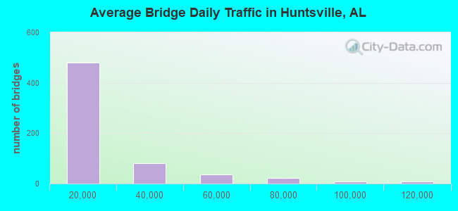
- 10,240,811Total average daily traffic
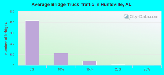
- 528,271Total average daily truck traffic
- National Bridge Inventory (NBI) Registered Bridges for Huntsville
- No street view available for this location
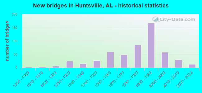
- New bridges - historical statistics
- 21900-1909
- 31910-1919
- 131920-1929
- 381930-1939
- 241940-1949
- 421950-1959
- 711960-1969
- 551970-1979
- 1011980-1989
- 1771990-1999
- 662000-2009
- 352010-2019
- 122020-2022
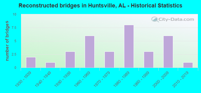
- Reconstructed bridges - Historical Statistics
- 21930-1939
- 11940-1949
- 31950-1959
- 61960-1969
- 31970-1979
- 81980-1989
- 31990-1999
- 62000-2009
- 12010-2019
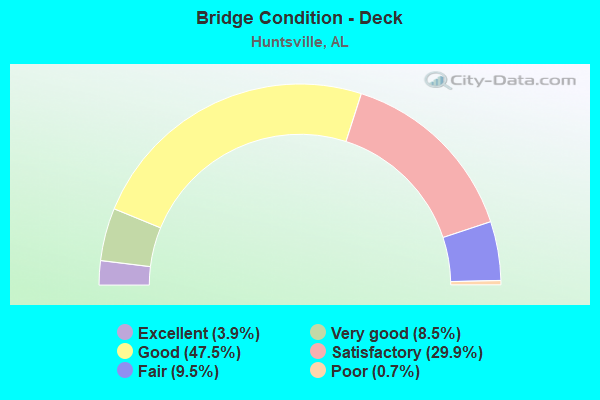
- Bridge Condition - Deck
- 3.9%Excellent
- 8.5%Very good
- 47.5%Good
- 29.9%Satisfactory
- 9.5%Fair
- 0.7%Poor
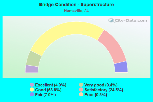
- Bridge Condition - Superstructure
- 4.9%Excellent
- 9.4%Very good
- 53.8%Good
- 24.5%Satisfactory
- 7.0%Fair
- 0.3%Poor
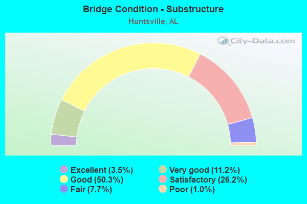
- Bridge Condition - Substructure
- 3.5%Excellent
- 11.2%Very good
- 50.3%Good
- 26.2%Satisfactory
- 7.7%Fair
- 1.0%Poor
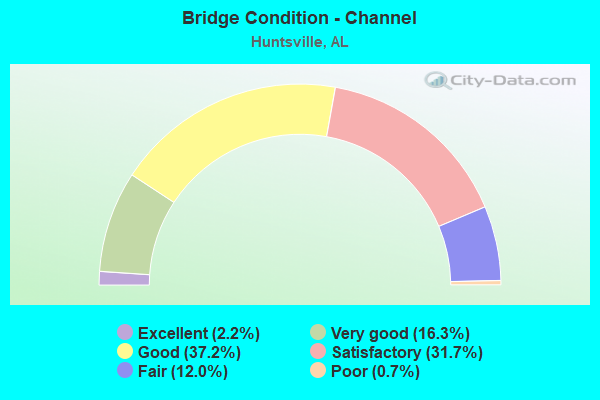
- Bridge Condition - Channel
- 2.2%Excellent
- 16.3%Very good
- 37.2%Good
- 31.7%Satisfactory
- 12.0%Fair
- 0.7%Poor
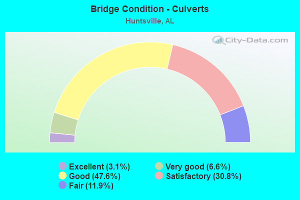
- Bridge Condition - Culverts
- 3.1%Excellent
- 6.6%Very good
- 47.6%Good
- 30.8%Satisfactory
- 11.9%Fair
Find on map >> Show street view
Structure Number: 14454, Location: 5.5 MI E COUNTY LINE RD (Lat: 34.696833, Lng: -86.700056), Route carried "on" structure: Interstate 565, Year Built: 1988, Status: Open, Structure Length: 10.00m (32.81ft), Average Daily Traffic: 38,595 (year 2019), Truck Traffic: 8%, Average Future Daily Traffic: 54,033 (year 2039), Design Load: HS 20, Features Intersected: INDIAN CREEK
Minimum Vertical Clearance: 7.56m (24.80ft), Kilometerpoint: 20.057, Lanes on structure: 3, Base Highway Network: Yes, Owner: State Highway Agency, Approaching Roadway Width: 17.1m (56.1ft), Material/Design: Prestressed concrete, Design/Construction: Stringer/Multi-beam, Number Of Spans In Main Unit: 8, Length of Maximum Span: 12.5m (41.0ft), Curb-To-Curb Width: 17.0m (55.8ft), Out-to-Out Width: 17.9m (58.7ft)
Condition: Deck: Satisfactory, Superstructure: Good, Substructure: Satisfactory, Channel: Satisfactory, Operating Rating: 49.8 metric tons, Method Used To Determine Operating Rating: Load Factor (LF), Inventory Rating: 28.2 metric tons, Method Used To Determine Inventory Rating: Load Factor (LF), Structural Evaluation: Equal to present minimum criteria, Deck Geometry: Equal to present minimum criteria, Waterway Adequacy: Equal to present minimum criteria, Approach Roadway Alignment: Equal to present desirable criteria, Length Of Structure Improvement: 10.93m (35.86ft), Designated Inspection Frequency: Every 24 months, Inspection Date: July 2021, Bridge Improvement Cost: $4,347,000, Roadway Improvement Cost: $435,000, Total Project Cost: $4,782,000 ( Estimate for 2022), Deck Structure Type: Concrete Cast-file-Place
Find on map >> Show street view
Structure Number: 14455, Location: 5.5 MI E COUNTY LINE ROAD (Lat: 34.696472, Lng: -86.699861), Route carried "on" structure: Interstate 565, Year Built: 1988, Status: Open, Structure Length: 10.00m (32.81ft), Average Daily Traffic: 38,595 (year 2019), Truck Traffic: 8%, Average Future Daily Traffic: 54,033 (year 2039), Design Load: HS 20, Features Intersected: INDIAN CREEK
Minimum Vertical Clearance: 30+ m (98+ ft), Kilometerpoint: 20.057, Lanes on structure: 3, Base Highway Network: Yes, Owner: State Highway Agency, Approaching Roadway Width: 17.1m (56.1ft), Material/Design: Prestressed concrete, Design/Construction: Stringer/Multi-beam, Number Of Spans In Main Unit: 8, Length of Maximum Span: 12.5m (41.0ft), Curb-To-Curb Width: 17.0m (55.8ft), Out-to-Out Width: 17.9m (58.7ft)
Condition: Deck: Satisfactory, Superstructure: Good, Substructure: Satisfactory, Channel: Satisfactory, Operating Rating: 49.8 metric tons, Method Used To Determine Operating Rating: Load Factor (LF), Inventory Rating: 28.2 metric tons, Method Used To Determine Inventory Rating: Load Factor (LF), Structural Evaluation: Equal to present minimum criteria, Deck Geometry: Equal to present minimum criteria, Waterway Adequacy: Equal to present minimum criteria, Approach Roadway Alignment: Equal to present desirable criteria, Length Of Structure Improvement: 10.93m (35.86ft), Designated Inspection Frequency: Every 24 months, Inspection Date: July 2021, Bridge Improvement Cost: $4,347,000, Roadway Improvement Cost: $435,000, Total Project Cost: $4,782,000 ( Estimate for 2022), Deck Structure Type: Concrete Cast-file-Place
Find on map >> Show street view
Structure Number: 14456, Location: 1 MI N JCT I 65 & I 565 (Lat: 34.642583, Lng: -86.905306), Route carried "on" structure: County highway 45, Year Built: 1988, Status: Open, Structure Length: 9.27m (30.41ft), Average Daily Traffic: 168 (year 2020), Truck Traffic: 1%, Average Future Daily Traffic: 290 (year 2035), Design Load: HS 20, Features Intersected: I 65, Facility Carried by Structure: BIBB GARRETT RD
Minimum Vertical Clearance: 30+ m (98+ ft), Kilometerpoint: 0.000, Lanes on structure: 2, Lanes under structure: 4, Owner: State Highway Agency, Approaching Roadway Width: 6.4m (21.0ft), Skew: 2 degrees, Material/Design: Prestressed concrete continuous, Design/Construction: Stringer/Multi-beam, Number Of Spans In Main Unit: 2, Number Of Approach Spans: 2, Length of Maximum Span: 27.7m (90.9ft), Curb-To-Curb Width: 8.4m (27.6ft), Out-to-Out Width: 9.3m (30.5ft)
Condition: Deck: Good, Superstructure: Good, Substructure: Good, Operating Rating: 61.7 metric tons, Method Used To Determine Operating Rating: Load Factor (LF), Inventory Rating: 36.9 metric tons, Method Used To Determine Inventory Rating: Load Factor (LF), Structural Evaluation: Better than present minimum criteria, Deck Geometry: Somewhat better than minimum adequacy, Underclear: Somewhat better than minimum adequacy, Approach Roadway Alignment: Better than present minimum criteria, Length Of Structure Improvement: 10.23m (33.56ft), Designated Inspection Frequency: Every 24 months, Inspection Date: March 2020, Bridge Improvement Cost: $2,104,000, Roadway Improvement Cost: $210,000, Total Project Cost: $2,314,000 ( Estimate for 2022), Deck Structure Type: Concrete Cast-file-Place
Find on map >> Show street view
Structure Number: 14517, Location: 10.9 MI N S-94 RAMER (Lat: 32.201544, Lng: -86.245467), Route carried "on" structure: County highway 9, Year Built: 1988, Status: Open, Structure Length: 1.46m (4.79ft), Average Daily Traffic: 525 (year 1988), Truck Traffic: 1%, Average Future Daily Traffic: 800 (year 2041), Design Load: HS 20, Features Intersected: DRAINAGE RELIEF, Facility Carried by Structure: HOBBIE ROAD
Minimum Vertical Clearance: 30+ m (98+ ft), Kilometerpoint: 0.010, Lanes on structure: 2, Owner: County Highway Agency, Approaching Roadway Width: 10.4m (34.1ft), Material/Design: Concrete, Design/Construction: Channel Beam, Number Of Spans In Main Unit: 2, Length of Maximum Span: 7.3m (24.0ft), Curb-To-Curb Width: 8.6m (28.2ft), Out-to-Out Width: 9.4m (30.8ft)
Condition: Deck: Very good, Superstructure: Good, Substructure: Very good, Channel: Good, Operating Rating: 62.2 metric tons, Method Used To Determine Operating Rating: Load Factor (LF), Inventory Rating: 37.4 metric tons, Method Used To Determine Inventory Rating: Load Factor (LF), Structural Evaluation: Better than present minimum criteria, Deck Geometry: Somewhat better than minimum adequacy, Waterway Adequacy: Better than present minimum criteria, Approach Roadway Alignment: Equal to present minimum criteria, Length Of Structure Improvement: 2.14m (7.02ft), Designated Inspection Frequency: Every 24 months, Inspection Date: May 2021, Bridge Improvement Cost: $440,000, Roadway Improvement Cost: $44,000, Total Project Cost: $484,000 ( Estimate for 2022), Deck Structure Type: Concrete Precast Panels
Find on map >> Show street view
Structure Number: 1454, Location: 1.2 M EAST OF HWY 231 S (Lat: 34.675000, Lng: -86.576667), Route carried "on" structure: City street , Year Built: 1988, Status: Open, Structure Length: 4.82m (15.81ft), Average Daily Traffic: 5,000 (year 2019), Truck Traffic: 1%, Average Future Daily Traffic: 7,000 (year 2039), Design Load: HS 20, Features Intersected: ALDRIDGE CREEK, Facility Carried by Structure: HOBBS ROAD
Minimum Vertical Clearance: 30+ m (98+ ft), Kilometerpoint: 0.010, Lanes on structure: 3, Owner: City or Municipal Highway Agency, Approaching Roadway Width: 13.4m (44.0ft), Material/Design: Prestressed concrete, Design/Construction: Stringer/Multi-beam, Number Of Spans In Main Unit: 3, Length of Maximum Span: 16.2m (53.1ft), Curb or Sidewalk Widths: Left: 1.8m (5.9ft), Right: 1.8m (5.9ft), Curb-To-Curb Width: 13.4m (44.0ft), Out-to-Out Width: 13.4m (44.0ft)
Condition: Deck: Good, Superstructure: Good, Substructure: Good, Channel: Good, Operating Rating: 74.3 metric tons, Method Used To Determine Operating Rating: Load Factor (LF), Inventory Rating: 44.5 metric tons, Method Used To Determine Inventory Rating: Load Factor (LF), Structural Evaluation: Better than present minimum criteria, Deck Geometry: Somewhat better than minimum adequacy, Waterway Adequacy: Better than present minimum criteria, Approach Roadway Alignment: Better than present minimum criteria, Length Of Structure Improvement: 5.83m (19.13ft), Designated Inspection Frequency: Every 24 months, Inspection Date: June 2020, Bridge Improvement Cost: $1,758,000, Roadway Improvement Cost: $176,000, Total Project Cost: $1,934,000 ( Estimate for 2022), Deck Structure Type: Concrete Cast-file-Place
Find on map >> Show street view
Structure Number: 14567, Location: 2 MI N MONROVIA ON DOUGRD (Lat: 34.801047, Lng: -86.707844), Route carried "on" structure: County highway 26, Year Built: 1988, Status: Open, Structure Length: 4.15m (13.62ft), Average Daily Traffic: 1,020 (year 1992), Truck Traffic: 1%, Average Future Daily Traffic: 1,395 (year 2040), Design Load: HS 20, Features Intersected: INDIAN CREEK, Facility Carried by Structure: DOUGLASS RD
Minimum Vertical Clearance: 30+ m (98+ ft), Kilometerpoint: 0.010, Lanes on structure: 2, Owner: County Highway Agency, Approaching Roadway Width: 10.4m (34.1ft), Material/Design: Concrete, Design/Construction: Channel Beam, Number Of Spans In Main Unit: 4, Length of Maximum Span: 10.4m (34.1ft), Curb-To-Curb Width: 8.5m (27.9ft), Out-to-Out Width: 9.8m (32.2ft)
Condition: Deck: Satisfactory, Superstructure: Good, Substructure: Satisfactory, Channel: Good, Operating Rating: 70.7 metric tons, Method Used To Determine Operating Rating: Load Factor (LF), Inventory Rating: 42.5 metric tons, Method Used To Determine Inventory Rating: Load Factor (LF), Structural Evaluation: Equal to present minimum criteria, Deck Geometry: Somewhat better than minimum adequacy, Waterway Adequacy: Equal to present desirable criteria, Approach Roadway Alignment: Equal to present desirable criteria, Length Of Structure Improvement: 5.12m (16.80ft), Designated Inspection Frequency: Every 24 months, Inspection Date: November 2020, Bridge Improvement Cost: $1,123,000, Roadway Improvement Cost: $112,000, Total Project Cost: $1,235,000 ( Estimate for 2022), Deck Structure Type: Concrete Precast Panels
Find on map >> Show street view
Structure Number: 14602, Location: 2.2 MILES EAST HWY 231 SO (Lat: 34.683333, Lng: -86.550000), Route carried "on" structure: City street , Year Built: 1988, Status: Open, Structure Length: 3.23m (10.60ft), Average Daily Traffic: 24,000 (year 2018), Truck Traffic: 1%, Average Future Daily Traffic: 33,600 (year 2038), Design Load: HS 20, Features Intersected: ALDRIDGE CREEK, Facility Carried by Structure: CARL T. JONES DR.
Minimum Vertical Clearance: 7.56m (24.80ft), Kilometerpoint: 2.200, Lanes on structure: 2, Owner: City or Municipal Highway Agency, Approaching Roadway Width: 8.2m (26.9ft), Skew: 3 degrees, Material/Design: Prestressed concrete, Design/Construction: Stringer/Multi-beam, Number Of Spans In Main Unit: 3, Length of Maximum Span: 11.0m (36.1ft), Curb or Sidewalk Widths: Left: 0.2m (0.7ft), Right: 2.3m (7.5ft), Curb-To-Curb Width: 8.2m (26.9ft), Out-to-Out Width: 11.5m (37.7ft)
Condition: Deck: Good, Superstructure: Good, Substructure: Good, Channel: Good, Operating Rating: 61.3 metric tons, Method Used To Determine Operating Rating: Load Factor (LF), Inventory Rating: 36.7 metric tons, Method Used To Determine Inventory Rating: Load Factor (LF), Structural Evaluation: Better than present minimum criteria, Deck Geometry: High priority of corrective action, Waterway Adequacy: Better than present minimum criteria, Approach Roadway Alignment: Better than present minimum criteria, Length Of Structure Improvement: 4.10m (13.45ft), Designated Inspection Frequency: Every 24 months, Inspection Date: July 2020, Bridge Improvement Cost: $1,040,000, Roadway Improvement Cost: $104,000, Total Project Cost: $1,144,000 ( Estimate for 2022), Deck Structure Type: Concrete Cast-file-Place
Find on map >> Show street view
Structure Number: 14603, Location: 2.2 MILES EAST HWY 231 S (Lat: 34.683333, Lng: -86.550000), Route carried "on" structure: City street , Year Built: 1988, Status: Open, Structure Length: 3.29m (10.79ft), Average Daily Traffic: 29,900 (year 2016), Truck Traffic: 1%, Average Future Daily Traffic: 41,860 (year 2036), Design Load: HS 20, Features Intersected: ALDRIDGE CREEK, Facility Carried by Structure: CARL T. JONES DR.
Minimum Vertical Clearance: 30+ m (98+ ft), Kilometerpoint: 2.200, Lanes on structure: 2, Owner: City or Municipal Highway Agency, Approaching Roadway Width: 8.2m (26.9ft), Skew: 3 degrees, Material/Design: Prestressed concrete, Design/Construction: Stringer/Multi-beam, Number Of Spans In Main Unit: 3, Length of Maximum Span: 11.0m (36.1ft), Curb or Sidewalk Widths: Left: 2.3m (7.5ft), Right: 0.2m (0.7ft), Curb-To-Curb Width: 8.2m (26.9ft), Out-to-Out Width: 11.5m (37.7ft)
Condition: Deck: Good, Superstructure: Good, Substructure: Good, Channel: Good, Operating Rating: 63.0 metric tons, Method Used To Determine Operating Rating: Load Factor (LF), Inventory Rating: 37.7 metric tons, Method Used To Determine Inventory Rating: Load Factor (LF), Structural Evaluation: Better than present minimum criteria, Deck Geometry: High priority of corrective action, Waterway Adequacy: Better than present minimum criteria, Approach Roadway Alignment: Better than present minimum criteria, Length Of Structure Improvement: 4.17m (13.68ft), Designated Inspection Frequency: Every 24 months, Inspection Date: July 2020, Bridge Improvement Cost: $1,057,000, Roadway Improvement Cost: $106,000, Total Project Cost: $1,163,000 ( Estimate for 2022), Deck Structure Type: Concrete Cast-file-Place
Find on map >> Show street view
Structure Number: 14609, Location: .25 M N FOUR MILE POST (Lat: 34.673333, Lng: -86.540000), Route carried "on" structure: City street , Year Built: 1988, Status: Open, Structure Length: 0.94m (3.08ft), Average Daily Traffic: 29,900 (year 2016), Truck Traffic: 1%, Average Future Daily Traffic: 41,860 (year 2036), Design Load: HS 20, Features Intersected: ALDRIDGE CREEK TRIB, Facility Carried by Structure: CARL T. JONES DR
Minimum Vertical Clearance: 30+ m (98+ ft), Kilometerpoint: 0.010, Lanes on structure: 4, Owner: City or Municipal Highway Agency, Approaching Roadway Width: 8.5m (27.9ft), Skew: 10 degrees, Material/Design: Concrete, Design/Construction: Culvert, Number Of Spans In Main Unit: 3, Length of Maximum Span: 3.0m (9.8ft), Curb or Sidewalk Widths: Left: 1.5m (4.9ft), Right: 1.5m (4.9ft)
Condition: Channel: Good, Culverts: Good, Operating Rating: 47.2 metric tons, Method Used To Determine Operating Rating: Load Factor (LF), Inventory Rating: 28.3 metric tons, Method Used To Determine Inventory Rating: Load Factor (LF), Structural Evaluation: Better than present minimum criteria, Waterway Adequacy: Better than present minimum criteria, Approach Roadway Alignment: Better than present minimum criteria, Length Of Structure Improvement: 1.61m (5.28ft), Designated Inspection Frequency: Every 24 months, Inspection Date: April 2020, Bridge Improvement Cost: $1,365,000, Roadway Improvement Cost: $137,000, Total Project Cost: $1,502,000 ( Estimate for 2022)
Find on map >> Show street view
Structure Number: 14625, Location: .5 MI WEST RIDEOUT RD (Lat: 34.713556, Lng: -86.683278), Route carried "on" structure: City street , Year Built: 1988, Status: Open, Structure Length: 0.75m (2.46ft), Average Daily Traffic: 14,500 (year 2015), Truck Traffic: 2%, Average Future Daily Traffic: 20,300 (year 2035), Design Load: HS 20, Features Intersected: CREEK, Facility Carried by Structure: OLD MADISON PIKE
Minimum Vertical Clearance: 7.56m (24.80ft), Kilometerpoint: 0.010, Lanes on structure: 4, Owner: City or Municipal Highway Agency, Approaching Roadway Width: 14.0m (45.9ft), Material/Design: Concrete, Design/Construction: Culvert, Number Of Spans In Main Unit: 2, Length of Maximum Span: 3.7m (12.1ft), Curb or Sidewalk Widths: Left: 1.5m (4.9ft), Right: 1.5m (4.9ft)
Condition: Channel: Good, Culverts: Good, Operating Rating: 88.9 metric tons, Method Used To Determine Operating Rating: Load Factor (LF), Inventory Rating: 88.9 metric tons, Method Used To Determine Inventory Rating: Load Factor (LF), Structural Evaluation: Better than present minimum criteria, Waterway Adequacy: Better than present minimum criteria, Approach Roadway Alignment: Better than present minimum criteria, Length Of Structure Improvement: 1.40m (4.59ft), Designated Inspection Frequency: Every 24 months, Underwater Inspection Frequency: Every 48 months, Inspection Date: November 2020, Underwater Inspection Date: November 2020, Bridge Improvement Cost: $1,856,000, Roadway Improvement Cost: $186,000, Total Project Cost: $2,042,000 ( Estimate for 2022)
Find on map >> Show street view
Structure Number: 14634, Location: .2 M N OF WINCHESTER RD (Lat: 34.796333, Lng: -86.589669), Route carried "on" structure: City street , Year Built: 1988, Status: Open, Structure Length: 0.98m (3.22ft), Average Daily Traffic: 890 (year 2015), Truck Traffic: 1%, Average Future Daily Traffic: 1,246 (year 2035), Design Load: H 20, Features Intersected: PINHOOK CREEK, Facility Carried by Structure: HOLLOW ROAD
Minimum Vertical Clearance: 30+ m (98+ ft), Kilometerpoint: 0.010, Lanes on structure: 2, Owner: City or Municipal Highway Agency, Approaching Roadway Width: 7.9m (25.9ft), Skew: 3 degrees, Material/Design: Concrete, Design/Construction: Culvert, Number Of Spans In Main Unit: 3, Length of Maximum Span: 3.4m (11.2ft), Curb-To-Curb Width: 8.6m (28.2ft), Out-to-Out Width: 10.7m (35.1ft)
Condition: Channel: Good, Culverts: Good, Operating Rating: 57.1 metric tons, Method Used To Determine Operating Rating: Load Factor (LF), Inventory Rating: 34.2 metric tons, Method Used To Determine Inventory Rating: Load Factor (LF), Structural Evaluation: Better than present minimum criteria, Deck Geometry: Somewhat better than minimum adequacy, Waterway Adequacy: Better than present minimum criteria, Approach Roadway Alignment: Better than present minimum criteria, Length Of Structure Improvement: 1.65m (5.41ft), Designated Inspection Frequency: Every 24 months, Inspection Date: April 2020, Bridge Improvement Cost: $1,003,000, Roadway Improvement Cost: $100,000, Total Project Cost: $1,103,000 ( Estimate for 2022)
Find on map >> Show street view
Structure Number: 14662, Location: 1.2 MI N JCT I565 * SR255 (Lat: 34.728083, Lng: -86.670664), Route carried "on" structure: City street , Year Built: 1988, Status: Open, Structure Length: 8.81m (28.90ft), Average Daily Traffic: 20,155 (year 2019), Truck Traffic: 4%, Average Future Daily Traffic: 28,217 (year 2039), Design Load: HS 20, Features Intersected: SR 255, Facility Carried by Structure: BRADFORD DRIVE
Minimum Vertical Clearance: 30+ m (98+ ft), Kilometerpoint: 0.010, Lanes on structure: 4, Lanes under structure: 4, Owner: State Highway Agency, Approaching Roadway Width: 36.6m (120.1ft), Skew: 20 degrees, Material/Design: Prestressed concrete, Design/Construction: Stringer/Multi-beam, Number Of Spans In Main Unit: 2, Number Of Approach Spans: 2, Length of Maximum Span: 25.9m (85.0ft), Curb-To-Curb Width: 36.6m (120.1ft), Out-to-Out Width: 37.4m (122.7ft)
Condition: Deck: Good, Superstructure: Good, Substructure: Satisfactory, Operating Rating: 48.1 metric tons, Method Used To Determine Operating Rating: Load Factor (LF), Inventory Rating: 30.5 metric tons, Method Used To Determine Inventory Rating: Load Factor (LF), Structural Evaluation: Equal to present minimum criteria, Deck Geometry: Superior to present desirable criteria, Underclear: Equal to present minimum criteria, Approach Roadway Alignment: Equal to present desirable criteria, Length Of Structure Improvement: 9.79m (32.12ft), Designated Inspection Frequency: Every 24 months, Inspection Date: October 2020, Bridge Improvement Cost: $8,187,000, Roadway Improvement Cost: $819,000, Total Project Cost: $9,006,000 ( Estimate for 2022), Deck Structure Type: Concrete Cast-file-Place
Find on map >> Show street view
Structure Number: 14667, Location: SEC31 T4S R3W (Lat: 34.642350, Lng: -86.891628), Route carried "on" structure: County highway 45A, Year Built: 1988, Status: Open, Structure Length: 5.18m (16.99ft), Average Daily Traffic: 300 (year 2014), Truck Traffic: 1%, Average Future Daily Traffic: 450 (year 2034), Design Load: HS 20, Features Intersected: PINEY CR, Facility Carried by Structure: BIBB-GARRETT RD
Minimum Vertical Clearance: 30+ m (98+ ft), Kilometerpoint: 0.010, Lanes on structure: 2, Owner: County Highway Agency, Approaching Roadway Width: 12.2m (40.0ft), Material/Design: Prestressed concrete, Design/Construction: Stringer/Multi-beam, Number Of Spans In Main Unit: 5, Length of Maximum Span: 10.4m (34.1ft), Curb-To-Curb Width: 8.6m (28.2ft), Out-to-Out Width: 9.4m (30.8ft)
Condition: Deck: Good, Superstructure: Very good, Substructure: Good, Channel: Good, Operating Rating: 55.8 metric tons, Method Used To Determine Operating Rating: Load Factor (LF), Inventory Rating: 33.7 metric tons, Method Used To Determine Inventory Rating: Load Factor (LF), Structural Evaluation: Better than present minimum criteria, Deck Geometry: Equal to present minimum criteria, Waterway Adequacy: Better than present minimum criteria, Approach Roadway Alignment: Equal to present desirable criteria, Length Of Structure Improvement: 6.20m (20.34ft), Designated Inspection Frequency: Every 24 months, Underwater Inspection Frequency: Every 48 months, Inspection Date: October 2020, Underwater Inspection Date: October 2018, Bridge Improvement Cost: $1,276,000, Roadway Improvement Cost: $128,000, Total Project Cost: $1,404,000 ( Estimate for 2022), Deck Structure Type: Concrete Cast-file-Place
Find on map >> Show street view
Structure Number: 14707, Location: 1.3 MI S CO RD 1305 (Lat: 34.795442, Lng: -86.500769), Route carried "on" structure: County highway 294, Year Built: 1989, Status: Open, Structure Length: 1.13m (3.71ft), Average Daily Traffic: 650 (year 1992), Truck Traffic: 1%, Average Future Daily Traffic: 880 (year 2035), Design Load: HS 20, Features Intersected: VOEGEL CREEK, Facility Carried by Structure: NAUGHER RD
Minimum Vertical Clearance: 30+ m (98+ ft), Kilometerpoint: 0.010, Lanes on structure: 2, Owner: County Highway Agency, Approaching Roadway Width: 10.4m (34.1ft), Skew: 4 degrees, Material/Design: Concrete, Design/Construction: Culvert, Number Of Spans In Main Unit: 2, Length of Maximum Span: 3.7m (12.1ft), Curb-To-Curb Width: 13.1m (43.0ft), Out-to-Out Width: 13.7m (44.9ft)
Condition: Channel: Satisfactory, Culverts: Satisfactory, Operating Rating: 52.8 metric tons, Method Used To Determine Operating Rating: Load Factor (LF), Inventory Rating: 31.7 metric tons, Method Used To Determine Inventory Rating: Load Factor (LF), Structural Evaluation: Equal to present minimum criteria, Deck Geometry: Superior to present desirable criteria, Waterway Adequacy: Equal to present minimum criteria, Approach Roadway Alignment: Better than present minimum criteria, Length Of Structure Improvement: 1.81m (5.94ft), Designated Inspection Frequency: Every 24 months, Inspection Date: September 2020, Bridge Improvement Cost: $605,000, Roadway Improvement Cost: $61,000, Total Project Cost: $666,000 ( Estimate for 2022)
Find on map >> Show street view
Structure Number: 14766, Location: 0.1 MI N JCT I565 * SR255 (Lat: 34.708306, Lng: -86.671417), Route carried "on" structure: State highway 255, Year Built: 1968, Year Reconstructed: 1989, Status: Open, Structure Length: 8.78m (28.81ft), Average Daily Traffic: 2,821 (year 2019), Truck Traffic: 3%, Average Future Daily Traffic: 3,949 (year 2039), Design Load: HS 20, Features Intersected: NORFOLK SOUTHERN
Minimum Vertical Clearance: 30+ m (98+ ft), Kilometerpoint: 0.805, Lanes on structure: 3, Lanes under structure: 2, Owner: State Highway Agency, Approaching Roadway Width: 15.8m (51.8ft), Skew: 11 degrees, Material/Design: Steel, Design/Construction: Stringer/Multi-beam, Number Of Spans In Main Unit: 4, Length of Maximum Span: 24.4m (80.1ft), Curb-To-Curb Width: 15.9m (52.2ft), Out-to-Out Width: 16.7m (54.8ft)
Condition: Deck: Satisfactory, Superstructure: Satisfactory, Substructure: Satisfactory, Operating Rating: 78.9 metric tons, Method Used To Determine Operating Rating: Load Factor (LF), Inventory Rating: 47.3 metric tons, Method Used To Determine Inventory Rating: Load Factor (LF), Structural Evaluation: Equal to present minimum criteria, Deck Geometry: Somewhat better than minimum adequacy, Underclear: Equal to present minimum criteria, Approach Roadway Alignment: Better than present minimum criteria, Length Of Structure Improvement: 9.76m (32.02ft), Designated Inspection Frequency: Every 24 months, Inspection Date: May 2021, Bridge Improvement Cost: $3,614,000, Roadway Improvement Cost: $361,000, Total Project Cost: $3,975,000 ( Estimate for 2022), Deck Structure Type: Concrete Cast-file-Place
Find on map >> Show street view
Structure Number: 14779, Location: 0.8 MI E JCT I565 * SR 53 (Lat: 34.723767, Lng: -86.614186), Route carried "on" structure: Spur Interstate 565, Year Built: 1989, Status: Open, Structure Length: 8.81m (28.90ft), Average Daily Traffic: 39,149 (year 2020), Truck Traffic: 6%, Average Future Daily Traffic: 54,809 (year 2040), Design Load: HS 20, Features Intersected: ABANDONED RR SPUR
Minimum Vertical Clearance: 30+ m (98+ ft), Kilometerpoint: 28.511, Lanes on structure: 4, Base Highway Network: Yes, Owner: State Highway Agency, Approaching Roadway Width: 21.0m (68.9ft), Skew: 10 degrees, Material/Design: Prestressed concrete continuous, Design/Construction: Stringer/Multi-beam, Number Of Spans In Main Unit: 3, Length of Maximum Span: 28.0m (91.9ft), Curb-To-Curb Width: 20.8m (68.2ft), Out-to-Out Width: 21.7m (71.2ft)
Condition: Deck: Good, Superstructure: Satisfactory, Substructure: Good, Operating Rating: 59.2 metric tons, Method Used To Determine Operating Rating: Load Factor (LF), Inventory Rating: 35.1 metric tons, Method Used To Determine Inventory Rating: Load Factor (LF), Structural Evaluation: Equal to present minimum criteria, Deck Geometry: Equal to present minimum criteria, Approach Roadway Alignment: Equal to present desirable criteria, Length Of Structure Improvement: 9.79m (32.12ft), Designated Inspection Frequency: Every 24 months, Inspection Date: August 2021, Bridge Improvement Cost: $4,765,000, Roadway Improvement Cost: $477,000, Total Project Cost: $5,242,000 ( Estimate for 2022), Deck Structure Type: Concrete Cast-file-Place
Find on map >> Show street view
Structure Number: 1478, Location: 0.8MI E JCT I565 * SR 53 (Lat: 34.723561, Lng: -86.613911), Route carried "on" structure: Spur Interstate 565, Year Built: 1989, Status: Open, Structure Length: 8.81m (28.90ft), Average Daily Traffic: 39,149 (year 2020), Truck Traffic: 6%, Average Future Daily Traffic: 54,809 (year 2040), Design Load: HS 20, Features Intersected: ABANDONED RR SPUR
Minimum Vertical Clearance: 30+ m (98+ ft), Kilometerpoint: 28.511, Lanes on structure: 4, Base Highway Network: Yes, Owner: State Highway Agency, Approaching Roadway Width: 21.0m (68.9ft), Skew: 14 degrees, Material/Design: Prestressed concrete continuous, Design/Construction: Stringer/Multi-beam, Number Of Spans In Main Unit: 3, Length of Maximum Span: 28.0m (91.9ft), Curb-To-Curb Width: 20.8m (68.2ft), Out-to-Out Width: 21.7m (71.2ft)
Condition: Deck: Satisfactory, Superstructure: Satisfactory, Substructure: Good, Operating Rating: 59.2 metric tons, Method Used To Determine Operating Rating: Load Factor (LF), Inventory Rating: 35.1 metric tons, Method Used To Determine Inventory Rating: Load Factor (LF), Structural Evaluation: Equal to present minimum criteria, Deck Geometry: Equal to present minimum criteria, Approach Roadway Alignment: Equal to present desirable criteria, Length Of Structure Improvement: 9.79m (32.12ft), Designated Inspection Frequency: Every 24 months, Inspection Date: August 2021, Bridge Improvement Cost: $4,765,000, Roadway Improvement Cost: $477,000, Total Project Cost: $5,242,000 ( Estimate for 2022), Deck Structure Type: Concrete Cast-file-Place
Find on map >> Show street view
Structure Number: 15033, Location: 0.1 MI N JCT I565 * SR255 (Lat: 34.708353, Lng: -86.671008), Route carried "on" structure: State highway 255, Year Built: 1968, Year Reconstructed: 1990, Status: Open, Structure Length: 8.78m (28.81ft), Average Daily Traffic: 2,821 (year 2019), Truck Traffic: 3%, Average Future Daily Traffic: 3,949 (year 2039), Design Load: HS 20, Features Intersected: NORFOLK SOUTHERN
Minimum Vertical Clearance: 30+ m (98+ ft), Kilometerpoint: 0.805, Lanes on structure: 3, Lanes under structure: 2, Owner: State Highway Agency, Approaching Roadway Width: 16.5m (54.1ft), Skew: 11 degrees, Material/Design: Steel, Design/Construction: Stringer/Multi-beam, Number Of Spans In Main Unit: 4, Length of Maximum Span: 24.4m (80.1ft), Curb-To-Curb Width: 16.5m (54.1ft), Out-to-Out Width: 17.3m (56.8ft)
Condition: Deck: Satisfactory, Superstructure: Satisfactory, Substructure: Satisfactory, Operating Rating: 79.7 metric tons, Method Used To Determine Operating Rating: Load Factor (LF), Inventory Rating: 47.7 metric tons, Method Used To Determine Inventory Rating: Load Factor (LF), Structural Evaluation: Equal to present minimum criteria, Deck Geometry: Equal to present minimum criteria, Underclear: Equal to present minimum criteria, Approach Roadway Alignment: Better than present minimum criteria, Length Of Structure Improvement: 9.76m (32.02ft), Designated Inspection Frequency: Every 24 months, Inspection Date: May 2021, Bridge Improvement Cost: $3,748,000, Roadway Improvement Cost: $375,000, Total Project Cost: $4,123,000 ( Estimate for 2022), Deck Structure Type: Concrete Cast-file-Place
Find on map >> Show street view
Structure Number: 15044, Location: 0.6 MI E JCT I 565 & I 65 (Lat: 34.630361, Lng: -86.892056), Route carried "on" structure: Interstate 565, Year Built: 1990, Status: Open, Structure Length: 7.50m (24.61ft), Average Daily Traffic: 26,590 (year 2019), Truck Traffic: 12%, Average Future Daily Traffic: 35,183 (year 2033), Design Load: HS 20, Features Intersected: SPRING CREEK
Minimum Vertical Clearance: 30+ m (98+ ft), Kilometerpoint: 1.127, Lanes on structure: 4, Owner: State Highway Agency, Approaching Roadway Width: 23.5m (77.1ft), Skew: 10 degrees, Material/Design: Prestressed concrete continuous, Design/Construction: Stringer/Multi-beam, Number Of Spans In Main Unit: 6, Length of Maximum Span: 12.5m (41.0ft), Curb-To-Curb Width: 19.5m (64.0ft), Out-to-Out Width: 20.4m (66.9ft)
Condition: Deck: Satisfactory, Superstructure: Good, Substructure: Good, Channel: Good, Operating Rating: 58.0 metric tons, Method Used To Determine Operating Rating: Load Factor (LF), Inventory Rating: 30.7 metric tons, Method Used To Determine Inventory Rating: Load Factor (LF), Structural Evaluation: Better than present minimum criteria, Deck Geometry: Somewhat better than minimum adequacy, Waterway Adequacy: Better than present minimum criteria, Approach Roadway Alignment: Equal to present desirable criteria, Length Of Structure Improvement: 8.52m (27.95ft), Designated Inspection Frequency: Every 24 months, Inspection Date: Febuary 2021, Bridge Improvement Cost: $3,857,000, Roadway Improvement Cost: $386,000, Total Project Cost: $4,243,000 ( Estimate for 2022), Deck Structure Type: Concrete Cast-file-Place
Find on map >> Show street view
Structure Number: 15045, Location: 0.6 MI E JCT I 565 & I 65 (Lat: 34.630000, Lng: -86.891750), Route carried "on" structure: Interstate 565, Year Built: 1990, Status: Open, Structure Length: 7.50m (24.61ft), Average Daily Traffic: 26,590 (year 2021), Truck Traffic: 12%, Average Future Daily Traffic: 35,183 (year 2033), Design Load: HS 20, Features Intersected: SPRING CREEK
Minimum Vertical Clearance: 30+ m (98+ ft), Kilometerpoint: 0.966, Lanes on structure: 3, Owner: State Highway Agency, Approaching Roadway Width: 17.7m (58.1ft), Skew: 10 degrees, Material/Design: Prestressed concrete continuous, Design/Construction: Stringer/Multi-beam, Number Of Spans In Main Unit: 6, Length of Maximum Span: 12.5m (41.0ft), Curb-To-Curb Width: 15.8m (51.8ft), Out-to-Out Width: 16.7m (54.8ft)
Condition: Deck: Good, Superstructure: Good, Substructure: Good, Channel: Good, Operating Rating: 58.6 metric tons, Method Used To Determine Operating Rating: Load Factor (LF), Inventory Rating: 30.8 metric tons, Method Used To Determine Inventory Rating: Load Factor (LF), Structural Evaluation: Better than present minimum criteria, Deck Geometry: Somewhat better than minimum adequacy, Waterway Adequacy: Better than present minimum criteria, Approach Roadway Alignment: Equal to present desirable criteria, Length Of Structure Improvement: 8.52m (27.95ft), Designated Inspection Frequency: Every 24 months, Inspection Date: Febuary 2021, Bridge Improvement Cost: $3,156,000, Roadway Improvement Cost: $316,000, Total Project Cost: $3,472,000 ( Estimate for 2022), Deck Structure Type: Concrete Cast-file-Place
Find on map >> Show street view
Structure Number: 15046, Location: 0.9 MI E JCT I 565 & I 65 (Lat: 34.631694, Lng: -86.887139), Route carried "on" structure: Interstate 565, Year Built: 1990, Status: Open, Structure Length: 11.25m (36.91ft), Average Daily Traffic: 26,590 (year 2021), Truck Traffic: 12%, Average Future Daily Traffic: 35,183 (year 2033), Design Load: HS 20, Features Intersected: PINEY CREEK
Minimum Vertical Clearance: 30+ m (98+ ft), Kilometerpoint: 1.447, Lanes on structure: 3, Owner: State Highway Agency, Approaching Roadway Width: 17.4m (57.1ft), Skew: 10 degrees, Material/Design: Prestressed concrete, Design/Construction: Stringer/Multi-beam, Number Of Spans In Main Unit: 9, Length of Maximum Span: 12.5m (41.0ft), Curb-To-Curb Width: 15.8m (51.8ft), Out-to-Out Width: 16.7m (54.8ft)
Condition: Deck: Good, Superstructure: Good, Substructure: Good, Channel: Good, Operating Rating: 59.9 metric tons, Method Used To Determine Operating Rating: Load Factor (LF), Inventory Rating: 33.6 metric tons, Method Used To Determine Inventory Rating: Load Factor (LF), Structural Evaluation: Better than present minimum criteria, Deck Geometry: Somewhat better than minimum adequacy, Waterway Adequacy: Better than present minimum criteria, Approach Roadway Alignment: Equal to present desirable criteria, Length Of Structure Improvement: 12.13m (39.80ft), Designated Inspection Frequency: Every 24 months, Inspection Date: Febuary 2021, Bridge Improvement Cost: $4,492,000, Roadway Improvement Cost: $449,000, Total Project Cost: $4,941,000 ( Estimate for 2022), Deck Structure Type: Concrete Cast-file-Place
Find on map >> Show street view
Structure Number: 15047, Location: 0.9 MI E JCT I 565 & I 65 (Lat: 34.648028, Lng: -86.887000), Route carried "on" structure: Interstate 565, Year Built: 1990, Status: Open, Structure Length: 11.25m (36.91ft), Average Daily Traffic: 26,590 (year 2021), Truck Traffic: 12%, Average Future Daily Traffic: 35,183 (year 2033), Design Load: HS 20, Features Intersected: PINEY CREEK
Minimum Vertical Clearance: 30+ m (98+ ft), Kilometerpoint: 1.447, Lanes on structure: 2, Owner: State Highway Agency, Approaching Roadway Width: 14.3m (46.9ft), Skew: 10 degrees, Material/Design: Prestressed concrete, Design/Construction: Stringer/Multi-beam, Number Of Spans In Main Unit: 9, Length of Maximum Span: 12.5m (41.0ft), Curb-To-Curb Width: 12.2m (40.0ft), Out-to-Out Width: 13.0m (42.7ft)
Condition: Deck: Satisfactory, Superstructure: Good, Substructure: Good, Channel: Very good, Operating Rating: 55.5 metric tons, Method Used To Determine Operating Rating: Load Factor (LF), Inventory Rating: 31.1 metric tons, Method Used To Determine Inventory Rating: Load Factor (LF), Structural Evaluation: Better than present minimum criteria, Deck Geometry: Better than present minimum criteria, Waterway Adequacy: Equal to present minimum criteria, Approach Roadway Alignment: Equal to present desirable criteria, Length Of Structure Improvement: 12.13m (39.80ft), Designated Inspection Frequency: Every 24 months, Inspection Date: Febuary 2021, Bridge Improvement Cost: $3,494,000, Roadway Improvement Cost: $349,000, Total Project Cost: $3,843,000 ( Estimate for 2022), Deck Structure Type: Concrete Cast-file-Place
Find on map >> Show street view
Structure Number: 15048, Location: .3 MI E JCT I-565 (Lat: 34.666392, Lng: -86.771131), Route carried "on" structure: Interstate 565, Year Built: 1990, Year Reconstructed: 2011, Status: Open, Structure Length: 2.59m (8.50ft), Average Daily Traffic: 31,818 (year 2019), Truck Traffic: 10%, Average Future Daily Traffic: 44,545 (year 2039), Design Load: HS 20, Features Intersected: JETPLEX IND. RD., Facility Carried by Structure: JETPLEX IND. RD.
Minimum Vertical Clearance: 30+ m (98+ ft), Kilometerpoint: 12.859, Lanes on structure: 3, Lanes under structure: 2, Base Highway Network: Yes, Owner: State Highway Agency, Approaching Roadway Width: 15.9m (52.2ft), Skew: 12 degrees, Material/Design: Prestressed concrete, Design/Construction: Stringer/Multi-beam, Number Of Spans In Main Unit: 1, Length of Maximum Span: 25.9m (85.0ft), Curb-To-Curb Width: 15.9m (52.2ft), Out-to-Out Width: 16.7m (54.8ft)
Condition: Deck: Good, Superstructure: Good, Substructure: Good, Operating Rating: 68.9 metric tons, Method Used To Determine Operating Rating: Load Factor (LF), Inventory Rating: 50.3 metric tons, Method Used To Determine Inventory Rating: Load Factor (LF), Structural Evaluation: Better than present minimum criteria, Deck Geometry: Somewhat better than minimum adequacy, Underclear: Equal to present minimum criteria, Approach Roadway Alignment: Equal to present desirable criteria, Length Of Structure Improvement: 3.49m (11.45ft), Designated Inspection Frequency: Every 24 months, Inspection Date: June 2021, Bridge Improvement Cost: $1,293,000, Roadway Improvement Cost: $129,000, Total Project Cost: $1,422,000 ( Estimate for 2022), Deck Structure Type: Concrete Cast-file-Place
Find on map >> Show street view
Structure Number: 15049, Location: .3 MI E JCT I565*JET PLEX (Lat: 34.666297, Lng: -86.771361), Route carried "on" structure: Interstate 565, Year Built: 1990, Status: Open, Structure Length: 2.59m (8.50ft), Average Daily Traffic: 31,818 (year 2019), Truck Traffic: 10%, Average Future Daily Traffic: 44,545 (year 2039), Design Load: HS 20, Features Intersected: JETPLEX IND. RD., Facility Carried by Structure: JETPLEX IND. RD.
Minimum Vertical Clearance: 30+ m (98+ ft), Kilometerpoint: 12.891, Lanes on structure: 3, Lanes under structure: 2, Base Highway Network: Yes, Owner: State Highway Agency, Approaching Roadway Width: 16.8m (55.1ft), Skew: 2 degrees, Material/Design: Prestressed concrete, Design/Construction: Stringer/Multi-beam, Number Of Spans In Main Unit: 1, Length of Maximum Span: 25.9m (85.0ft), Curb-To-Curb Width: 15.8m (51.8ft), Out-to-Out Width: 16.8m (55.1ft)
Condition: Deck: Good, Superstructure: Very good, Substructure: Good, Operating Rating: 76.5 metric tons, Method Used To Determine Operating Rating: Load Factor (LF), Inventory Rating: 50.3 metric tons, Method Used To Determine Inventory Rating: Load Factor (LF), Structural Evaluation: Better than present minimum criteria, Deck Geometry: Somewhat better than minimum adequacy, Approach Roadway Alignment: Equal to present desirable criteria, Length Of Structure Improvement: 3.49m (11.45ft), Designated Inspection Frequency: Every 24 months, Inspection Date: June 2021, Bridge Improvement Cost: $1,317,000, Roadway Improvement Cost: $132,000, Total Project Cost: $1,449,000 ( Estimate for 2022), Deck Structure Type: Concrete Cast-file-Place
Find on map >> Show street view
Structure Number: 1505, Location: 0.3 MI W SR255 * I565 (Lat: 34.703322, Lng: -86.684139), Route carried "on" structure: Interstate 565, Year Built: 1990, Status: Open, Structure Length: 2.19m (7.19ft), Average Daily Traffic: 53,448 (year 2019), Truck Traffic: 7%, Average Future Daily Traffic: 74,827 (year 2039), Design Load: HS 20, Features Intersected: NORHFOLK SOUTHERN R.R.
Minimum Vertical Clearance: 30+ m (98+ ft), Kilometerpoint: 22.119, Lanes on structure: 6, Base Highway Network: Yes, Owner: State Highway Agency, Approaching Roadway Width: 30.5m (100.1ft), Skew: 1 degrees, Material/Design: Prestressed concrete, Design/Construction: Stringer/Multi-beam, Number Of Spans In Main Unit: 1, Length of Maximum Span: 21.9m (71.9ft), Curb-To-Curb Width: 30.5m (100.1ft), Out-to-Out Width: 31.4m (103.0ft)
Condition: Deck: Good, Superstructure: Very good, Substructure: Good, Operating Rating: 62.5 metric tons, Method Used To Determine Operating Rating: Load Factor (LF), Inventory Rating: 31.9 metric tons, Method Used To Determine Inventory Rating: Load Factor (LF), Structural Evaluation: Better than present minimum criteria, Deck Geometry: Superior to present desirable criteria, Underclear: Superior to present desirable criteria, Approach Roadway Alignment: Equal to present desirable criteria, Length Of Structure Improvement: 2.99m (9.81ft), Designated Inspection Frequency: Every 24 months, Inspection Date: June 2021, Bridge Improvement Cost: $2,113,000, Roadway Improvement Cost: $211,000, Total Project Cost: $2,324,000 ( Estimate for 2022), Deck Structure Type: Concrete Cast-file-Place
Find on map >> Show street view
Structure Number: 15051, Location: 0.3 MI W JCT SR255 * I565 (Lat: 34.703033, Lng: -86.684189), Route carried "on" structure: Interstate 565, Year Built: 1990, Status: Open, Structure Length: 2.19m (7.19ft), Average Daily Traffic: 53,448 (year 2019), Truck Traffic: 7%, Average Future Daily Traffic: 74,827 (year 2039), Design Load: HS 20, Features Intersected: NORTHFOLK SOUTHERN R.R.
Minimum Vertical Clearance: 30+ m (98+ ft), Kilometerpoint: 22.119, Lanes on structure: 4, Base Highway Network: Yes, Owner: State Highway Agency, Approaching Roadway Width: 30.2m (99.1ft), Skew: 31 degrees, Material/Design: Prestressed concrete, Design/Construction: Stringer/Multi-beam, Number Of Spans In Main Unit: 1, Length of Maximum Span: 21.9m (71.9ft), Curb-To-Curb Width: 29.6m (97.1ft), Out-to-Out Width: 30.5m (100.1ft)
Condition: Deck: Good, Superstructure: Good, Substructure: Good, Operating Rating: 52.7 metric tons, Method Used To Determine Operating Rating: Load Factor (LF), Inventory Rating: 39.0 metric tons, Method Used To Determine Inventory Rating: Load Factor (LF), Structural Evaluation: Better than present minimum criteria, Deck Geometry: Superior to present desirable criteria, Underclear: Superior to present desirable criteria, Approach Roadway Alignment: Equal to present desirable criteria, Length Of Structure Improvement: 2.99m (9.81ft), Designated Inspection Frequency: Every 24 months, Inspection Date: June 2021, Bridge Improvement Cost: $2,051,000, Roadway Improvement Cost: $205,000, Total Project Cost: $2,256,000 ( Estimate for 2022), Deck Structure Type: Concrete Cast-file-Place
Find on map >> Show street view
Structure Number: 15052, Location: 0.3 MI W SR 255 * I-565 (Lat: 34.702728, Lng: -86.684222), Route carried "on" structure: Interstate 565, Year Built: 1990, Status: Open, Structure Length: 1.92m (6.30ft), Average Daily Traffic: 15,015 (year 2019), Truck Traffic: 4%, Average Future Daily Traffic: 21,021 (year 2039), Design Load: HS 20, Features Intersected: NORTHFORK SOUTHERN R. R., Facility Carried by Structure: RAMP TO SR 255*RA
Minimum Vertical Clearance: 30+ m (98+ ft), Kilometerpoint: 22.119, Lanes on structure: 2, Base Highway Network: Yes, Owner: State Highway Agency, Approaching Roadway Width: 30.5m (100.1ft), Skew: 31 degrees, Material/Design: Prestressed concrete, Design/Construction: Stringer/Multi-beam, Number Of Spans In Main Unit: 1, Length of Maximum Span: 19.2m (63.0ft), Curb-To-Curb Width: 29.2m (95.8ft), Out-to-Out Width: 30.2m (99.1ft)
Condition: Deck: Good, Superstructure: Good, Substructure: Good, Operating Rating: 76.2 metric tons, Method Used To Determine Operating Rating: Load Factor (LF), Inventory Rating: 45.6 metric tons, Method Used To Determine Inventory Rating: Load Factor (LF), Structural Evaluation: Better than present minimum criteria, Deck Geometry: Superior to present desirable criteria, Underclear: Superior to present desirable criteria, Approach Roadway Alignment: Equal to present desirable criteria, Length Of Structure Improvement: 2.65m (8.69ft), Designated Inspection Frequency: Every 24 months, Inspection Date: June 2021, Bridge Improvement Cost: $1,801,000, Roadway Improvement Cost: $180,000, Total Project Cost: $1,981,000 ( Estimate for 2022), Deck Structure Type: Concrete Cast-file-Place
Find on map >> Show street view
Structure Number: 15053, Location: 0.3 MI WEST SR 255 (Lat: 34.707361, Lng: -86.677000), Route carried "on" structure: City street , Year Built: 1990, Status: Open, Structure Length: 5.46m (17.91ft), Average Daily Traffic: 9,000 (year 2015), Truck Traffic: 3%, Average Future Daily Traffic: 12,600 (year 2035), Design Load: HS 20, Features Intersected: NORFOLK SOUTHERN R.R., Facility Carried by Structure: GOVERNOR'S WEST
Minimum Vertical Clearance: 30+ m (98+ ft), Kilometerpoint: 3.199, Lanes on structure: 2, Owner: City or Municipal Highway Agency, Approaching Roadway Width: 12.5m (41.0ft), Skew: 6 degrees, Material/Design: Steel, Design/Construction: Stringer/Multi-beam, Number Of Spans In Main Unit: 1, Length of Maximum Span: 54.6m (179.1ft), Curb-To-Curb Width: 12.2m (40.0ft), Out-to-Out Width: 13.0m (42.7ft)
Condition: Deck: Good, Superstructure: Good, Substructure: Good, Operating Rating: 88.9 metric tons, Method Used To Determine Operating Rating: Load Factor (LF), Inventory Rating: 70.7 metric tons, Method Used To Determine Inventory Rating: Load Factor (LF), Structural Evaluation: Better than present minimum criteria, Deck Geometry: Somewhat better than minimum adequacy, Underclear: Superior to present desirable criteria, Approach Roadway Alignment: Equal to present minimum criteria, Length Of Structure Improvement: 6.49m (21.29ft), Designated Inspection Frequency: Every 24 months, Inspection Date: October 2020, Bridge Improvement Cost: $1,868,000, Roadway Improvement Cost: $187,000, Total Project Cost: $2,055,000 ( Estimate for 2022), Deck Structure Type: Concrete Cast-file-Place
Find on map >> Show street view
Structure Number: 15054, Location: JCT.OLD MADISON PK*SOU.RR (Lat: 34.714667, Lng: -86.648083), Route carried "on" structure: City street , Year Built: 1990, Status: Open, Structure Length: 5.09m (16.70ft), Average Daily Traffic: 11,100 (year 2015), Truck Traffic: 2%, Average Future Daily Traffic: 15,540 (year 2035), Design Load: HS 20, Features Intersected: SOUTHERN RR*SHERWOOD CRK, Facility Carried by Structure: 0LD MADISON PIKE
Minimum Vertical Clearance: 7.56m (24.80ft), Kilometerpoint: 0.000, Lanes on structure: 4, Owner: City or Municipal Highway Agency, Approaching Roadway Width: 22.2m (72.8ft), Skew: 20 degrees, Material/Design: Prestressed concrete, Design/Construction: Stringer/Multi-beam, Number Of Spans In Main Unit: 2, Length of Maximum Span: 31.7m (104.0ft), Curb or Sidewalk Widths: Left: 1.5m (4.9ft), Right: 1.5m (4.9ft), Curb-To-Curb Width: 22.2m (72.8ft), Out-to-Out Width: 28.1m (92.2ft)
Condition: Deck: Good, Superstructure: Good, Substructure: Good, Channel: Good, Operating Rating: 61.3 metric tons, Method Used To Determine Operating Rating: Load Factor (LF), Inventory Rating: 29.0 metric tons, Method Used To Determine Inventory Rating: Load Factor (LF), Structural Evaluation: Better than present minimum criteria, Deck Geometry: Superior to present desirable criteria, Underclear: Equal to present desirable criteria, Waterway Adequacy: Better than present minimum criteria, Approach Roadway Alignment: Equal to present minimum criteria, Length Of Structure Improvement: 6.11m (20.05ft), Designated Inspection Frequency: Every 24 months, Inspection Date: October 2020, Bridge Improvement Cost: $3,855,000, Roadway Improvement Cost: $386,000, Total Project Cost: $4,241,000 ( Estimate for 2022), Deck Structure Type: Concrete Cast-file-Place
Find on map >> Show street view
Structure Number: 15055, Location: JCT. SPKMAN DR*SOU.RR (Lat: 34.700269, Lng: -86.633511), Route carried "on" structure: City street , Year Built: 1990, Status: Open, Structure Length: 1.95m (6.40ft), Average Daily Traffic: 22,000 (year 2019), Truck Traffic: 2%, Average Future Daily Traffic: 30,800 (year 2039), Design Load: HS 20, Features Intersected: SOUTHERN RR, Facility Carried by Structure: SPARKMAN DR
Minimum Vertical Clearance: 30+ m (98+ ft), Kilometerpoint: 0.000, Lanes on structure: 8, Owner: City or Municipal Highway Agency, Approaching Roadway Width: 31.7m (104.0ft), Skew: 20 degrees, Material/Design: Prestressed concrete, Design/Construction: Stringer/Multi-beam, Number Of Spans In Main Unit: 1, Length of Maximum Span: 19.5m (64.0ft), Curb or Sidewalk Widths: Left: 1.5m (4.9ft), Right: 1.5m (4.9ft), Curb-To-Curb Width: 31.7m (104.0ft), Out-to-Out Width: 40.2m (131.9ft)
Condition: Deck: Good, Superstructure: Good, Substructure: Very good, Operating Rating: 61.7 metric tons, Method Used To Determine Operating Rating: Load Factor (LF), Inventory Rating: 28.7 metric tons, Method Used To Determine Inventory Rating: Load Factor (LF), Structural Evaluation: Better than present minimum criteria, Deck Geometry: Somewhat better than minimum adequacy, Underclear: Better than present minimum criteria, Approach Roadway Alignment: Better than present minimum criteria, Length Of Structure Improvement: 2.69m (8.83ft), Designated Inspection Frequency: Every 24 months, Inspection Date: Febuary 2022, Bridge Improvement Cost: $2,417,000, Roadway Improvement Cost: $242,000, Total Project Cost: $2,659,000 ( Estimate for 2022), Deck Structure Type: Concrete Cast-file-Place
Find on map >> Show street view
Structure Number: 15056, Location: .3 MILE E JCT JORDON LANE (Lat: 34.721297, Lng: -86.623100), Route carried "on" structure: State highway 53, Year Built: 1990, Status: Open, Structure Length: 16.61m (54.49ft), Average Daily Traffic: 28,627 (year 2020), Truck Traffic: 4%, Average Future Daily Traffic: 40,078 (year 2040), Design Load: HS 20, Features Intersected: I-565
Minimum Vertical Clearance: 30+ m (98+ ft), Kilometerpoint: 512.320, Lanes on structure: 2, Lanes under structure: 9, Base Highway Network: Yes, Owner: State Highway Agency, Approaching Roadway Width: 11.6m (38.1ft), Skew: 3 degrees, Material/Design: Steel continuous, Design/Construction: Stringer/Multi-beam, Number Of Spans In Main Unit: 2, Number Of Approach Spans: 2, Length of Maximum Span: 44.5m (146.0ft), Curb-To-Curb Width: 11.7m (38.4ft), Out-to-Out Width: 12.2m (40.0ft)
Condition: Deck: Satisfactory, Superstructure: Satisfactory, Substructure: Good, Operating Rating: 45.1 metric tons, Method Used To Determine Operating Rating: Load Factor (LF), Inventory Rating: 27.0 metric tons, Method Used To Determine Inventory Rating: Load Factor (LF), Structural Evaluation: Equal to present minimum criteria, Deck Geometry: Better than present minimum criteria, Underclear: Equal to present minimum criteria, Approach Roadway Alignment: Better than present minimum criteria, Length Of Structure Improvement: 17.34m (56.89ft), Designated Inspection Frequency: Every 24 months, Inspection Date: October 2021, Bridge Improvement Cost: $4,757,000, Roadway Improvement Cost: $476,000, Total Project Cost: $5,233,000 ( Estimate for 2022), Deck Structure Type: Concrete Cast-file-Place
Find on map >> Show street view
Structure Number: 15057, Location: .1 M S JCT JEFF.ST.* I565 (Lat: 34.736667, Lng: -86.588333), Route carried "on" structure: City street , Year Built: 1990, Status: Open, Structure Length: 20.63m (67.68ft), Average Daily Traffic: 8,910 (year 2017), Truck Traffic: 5%, Average Future Daily Traffic: 12,474 (year 2037), Design Load: HS 20, Features Intersected: SOU. RR * CLEVELAND ST, Facility Carried by Structure: JEFFERSON STREET
Minimum Vertical Clearance: 30+ m (98+ ft), Kilometerpoint: 0.010, Lanes on structure: 3, Lanes under structure: 2, Owner: City or Municipal Highway Agency, Approaching Roadway Width: 13.1m (43.0ft), Material/Design: Steel continuous, Design/Construction: Stringer/Multi-beam, Number Of Spans In Main Unit: 4, Length of Maximum Span: 65.2m (213.9ft), Curb or Sidewalk Widths: Left: 1.5m (4.9ft), Right: 0.0m, Curb-To-Curb Width: 16.4m (53.8ft), Out-to-Out Width: 18.8m (61.7ft)
Condition: Deck: Good, Superstructure: Satisfactory, Substructure: Good, Channel: Good, Operating Rating: 65.9 metric tons, Method Used To Determine Operating Rating: Load Factor (LF), Inventory Rating: 39.5 metric tons, Method Used To Determine Inventory Rating: Load Factor (LF), Structural Evaluation: Equal to present minimum criteria, Deck Geometry: Better than present minimum criteria, Underclear: Superior to present desirable criteria, Waterway Adequacy: Better than present minimum criteria, Approach Roadway Alignment: Better than present minimum criteria, Length Of Structure Improvement: 20.63m (67.68ft), Designated Inspection Frequency: Every 24 months, Inspection Date: April 2021, Bridge Improvement Cost: $8,629,000, Roadway Improvement Cost: $863,000, Total Project Cost: $9,492,000 ( Estimate for 2022), Deck Structure Type: Concrete Cast-file-Place
Find on map >> Show street view
Structure Number: 15058, Location: .1 M S JCT WASH ST * I565 (Lat: 34.736667, Lng: -86.588333), Route carried "on" structure: City street , Year Built: 1990, Status: Open, Structure Length: 13.72m (45.01ft), Average Daily Traffic: 9,460 (year 2017), Truck Traffic: 5%, Average Future Daily Traffic: 13,244 (year 2035), Design Load: HS 20, Features Intersected: SOU RR * CLEVELAND ST, Facility Carried by Structure: WASHINGTON STREET
Minimum Vertical Clearance: 5.49m (18.01ft), Kilometerpoint: 0.010, Lanes on structure: 4, Lanes under structure: 2, Owner: City or Municipal Highway Agency, Approaching Roadway Width: 12.2m (40.0ft), Material/Design: Steel continuous, Design/Construction: Stringer/Multi-beam, Number Of Spans In Main Unit: 4, Length of Maximum Span: 47.9m (157.2ft), Curb or Sidewalk Widths: Left: 0.0m, Right: 1.5m (4.9ft), Curb-To-Curb Width: 20.3m (66.6ft), Out-to-Out Width: 22.6m (74.1ft)
Condition: Deck: Good, Superstructure: Good, Substructure: Good, Channel: Good, Operating Rating: 43.1 metric tons, Method Used To Determine Operating Rating: Load Factor (LF), Inventory Rating: 25.8 metric tons, Method Used To Determine Inventory Rating: Load Factor (LF), Structural Evaluation: Equal to present minimum criteria, Deck Geometry: Equal to present desirable criteria, Underclear: Somewhat better than minimum adequacy, Waterway Adequacy: Better than present minimum criteria, Approach Roadway Alignment: Better than present minimum criteria, Length Of Structure Improvement: 14.52m (47.64ft), Designated Inspection Frequency: Every 24 months, Inspection Date: April 2021, Bridge Improvement Cost: $7,369,000, Roadway Improvement Cost: $737,000, Total Project Cost: $8,106,000 ( Estimate for 2022), Deck Structure Type: Concrete Cast-file-Place
Find on map >> Show street view
Structure Number: 15178, Location: 1.9 MI N Sumer Co Line (Lat: 32.842200, Lng: -88.131083), Route carried "on" structure: State highway 39, Year Built: 1990, Status: Open, Structure Length: 6.25m (20.51ft), Average Daily Traffic: 1,179 (year 2020), Truck Traffic: 18%, Average Future Daily Traffic: 1,623 (year 2033), Design Load: HS 20, Features Intersected: Tombigbee River Relief
Minimum Vertical Clearance: 30+ m (98+ ft), Kilometerpoint: 21.190, Lanes on structure: 2, Owner: State Highway Agency, Approaching Roadway Width: 11.0m (36.1ft), Material/Design: Prestressed concrete continuous, Design/Construction: Stringer/Multi-beam, Number Of Spans In Main Unit: 5, Length of Maximum Span: 12.5m (41.0ft), Curb-To-Curb Width: 10.3m (33.8ft), Out-to-Out Width: 11.2m (36.7ft)
Condition: Deck: Good, Superstructure: Good, Substructure: Good, Channel: Very good, Operating Rating: 60.7 metric tons, Method Used To Determine Operating Rating: Load Factor (LF), Inventory Rating: 36.3 metric tons, Method Used To Determine Inventory Rating: Load Factor (LF), Structural Evaluation: Better than present minimum criteria, Deck Geometry: Somewhat better than minimum adequacy, Waterway Adequacy: Equal to present minimum criteria, Approach Roadway Alignment: Equal to present desirable criteria, Length Of Structure Improvement: 7.29m (23.92ft), Designated Inspection Frequency: Every 24 months, Inspection Date: December 2020, Bridge Improvement Cost: $1,800,000, Roadway Improvement Cost: $180,000, Total Project Cost: $1,980,000 ( Estimate for 2022), Deck Structure Type: Concrete Cast-file-Place
Find on map >> Show street view
Structure Number: 15197, Location: JCT SR 53 * I 565 (Lat: 34.718961, Lng: -86.627661), Route carried "on" structure: State highway 53, Year Built: 1990, Status: Open, Structure Length: 10.33m (33.89ft), Average Daily Traffic: 28,972 (year 2020), Truck Traffic: 4%, Average Future Daily Traffic: 40,561 (year 2040), Design Load: HS 20, Features Intersected: I565, Facility Carried by Structure: JORDAN LN
Minimum Vertical Clearance: 30+ m (98+ ft), Kilometerpoint: 512.256, Lanes on structure: 10, Lanes under structure: 11, Base Highway Network: Yes, Owner: State Highway Agency, Approaching Roadway Width: 36.6m (120.1ft), Skew: 21 degrees, Material/Design: Prestressed concrete continuous, Design/Construction: Stringer/Multi-beam, Number Of Spans In Main Unit: 2, Number Of Approach Spans: 2, Length of Maximum Span: 37.2m (122.0ft), Curb or Sidewalk Widths: Left: 1.5m (4.9ft), Right: 1.5m (4.9ft), Curb-To-Curb Width: 39.1m (128.3ft), Out-to-Out Width: 42.9m (140.7ft)
Condition: Deck: Satisfactory, Superstructure: Satisfactory, Substructure: Good, Operating Rating: 59.7 metric tons, Method Used To Determine Operating Rating: Load Factor (LF), Inventory Rating: 35.7 metric tons, Method Used To Determine Inventory Rating: Load Factor (LF), Structural Evaluation: Equal to present minimum criteria, Deck Geometry: Somewhat better than minimum adequacy, Underclear: Equal to present minimum criteria, Approach Roadway Alignment: Better than present minimum criteria, Length Of Structure Improvement: 11.25m (36.91ft), Designated Inspection Frequency: Every 24 months, Inspection Date: Febuary 2022, Bridge Improvement Cost: $10,796,000, Roadway Improvement Cost: $1,080,000, Total Project Cost: $11,876,000 ( Estimate for 2022), Deck Structure Type: Concrete Cast-file-Place
Find on map >> Show street view
Structure Number: 15198, Location: JCT SR53 * SOUTHERN RR (Lat: 34.720800, Lng: -86.627544), Route carried "on" structure: State highway 53, Year Built: 1990, Status: Open, Structure Length: 2.04m (6.69ft), Average Daily Traffic: 28,972 (year 2020), Truck Traffic: 4%, Average Future Daily Traffic: 40,561 (year 2040), Design Load: HS 20, Features Intersected: NORTHFORK * SOUTHERN RR
Minimum Vertical Clearance: 30+ m (98+ ft), Kilometerpoint: 512.417, Lanes on structure: 8, Base Highway Network: Yes, Owner: State Highway Agency, Approaching Roadway Width: 32.9m (107.9ft), Skew: 20 degrees, Material/Design: Prestressed concrete, Design/Construction: Stringer/Multi-beam, Number Of Spans In Main Unit: 1, Length of Maximum Span: 20.4m (66.9ft), Curb or Sidewalk Widths: Left: 1.5m (4.9ft), Right: 1.5m (4.9ft), Curb-To-Curb Width: 33.1m (108.6ft), Out-to-Out Width: 42.6m (139.8ft)
Condition: Deck: Good, Superstructure: Good, Substructure: Satisfactory, Operating Rating: 57.6 metric tons, Method Used To Determine Operating Rating: Load Factor (LF), Inventory Rating: 44.1 metric tons, Method Used To Determine Inventory Rating: Load Factor (LF), Structural Evaluation: Equal to present minimum criteria, Deck Geometry: Somewhat better than minimum adequacy, Underclear: Equal to present desirable criteria, Approach Roadway Alignment: Better than present minimum criteria, Length Of Structure Improvement: 2.80m (9.19ft), Designated Inspection Frequency: Every 24 months, Inspection Date: Febuary 2022, Bridge Improvement Cost: $2,668,000, Roadway Improvement Cost: $267,000, Total Project Cost: $2,935,000 ( Estimate for 2022), Deck Structure Type: Concrete Cast-file-Place
Find on map >> Show street view
Structure Number: 15228, Location: SEC15 T5S R3W (Lat: 34.607339, Lng: -86.843014), Route carried "on" structure: County highway 115, Year Built: 1990, Status: Open, Structure Length: 4.57m (14.99ft), Average Daily Traffic: 920 (year 2014), Truck Traffic: 1%, Average Future Daily Traffic: 1,360 (year 2034), Design Load: HS 20, Features Intersected: BEAVERDAM CR, Facility Carried by Structure: SWANCOTT RD
Minimum Vertical Clearance: 30+ m (98+ ft), Kilometerpoint: 0.010, Lanes on structure: 2, Owner: County Highway Agency, Approaching Roadway Width: 10.4m (34.1ft), Material/Design: Prestressed concrete, Design/Construction: Stringer/Multi-beam, Number Of Spans In Main Unit: 3, Length of Maximum Span: 15.2m (49.9ft), Curb-To-Curb Width: 8.5m (27.9ft), Out-to-Out Width: 9.4m (30.8ft)
Condition: Deck: Good, Superstructure: Good, Substructure: Good, Channel: Good, Operating Rating: 61.6 metric tons, Method Used To Determine Operating Rating: Load Factor (LF), Inventory Rating: 36.9 metric tons, Method Used To Determine Inventory Rating: Load Factor (LF), Structural Evaluation: Better than present minimum criteria, Deck Geometry: Somewhat better than minimum adequacy, Waterway Adequacy: Better than present minimum criteria, Approach Roadway Alignment: Better than present minimum criteria, Length Of Structure Improvement: 5.56m (18.24ft), Designated Inspection Frequency: Every 24 months, Underwater Inspection Frequency: Every 48 months, Inspection Date: October 2020, Underwater Inspection Date: October 2018, Bridge Improvement Cost: $1,145,000, Roadway Improvement Cost: $115,000, Total Project Cost: $1,260,000 ( Estimate for 2022), Deck Structure Type: Concrete Cast-file-Place
Find on map >> Show street view
Structure Number: 15253, Location: JCT SR 255 * I-565 (Lat: 34.706667, Lng: -86.673333), Route carried "on" structure: State highway 255, Year Built: 1990, Status: Open, Structure Length: 13.75m (45.11ft), Average Daily Traffic: 17,065 (year 2019), Truck Traffic: 2%, Average Future Daily Traffic: 23,891 (year 2039), Design Load: HS 20, Features Intersected: I-565, Facility Carried by Structure: RESEARCH PK BLVD
Minimum Vertical Clearance: 30+ m (98+ ft), Kilometerpoint: 0.002, Lanes on structure: 3, Lanes under structure: 11, Base Highway Network: Yes, Owner: State Highway Agency, Approaching Roadway Width: 15.5m (50.9ft), Skew: 10 degrees, Material/Design: Prestressed concrete continuous, Design/Construction: Stringer/Multi-beam, Number Of Spans In Main Unit: 5, Length of Maximum Span: 32.3m (106.0ft), Curb-To-Curb Width: 15.8m (51.8ft), Out-to-Out Width: 16.7m (54.8ft)
Condition: Deck: Good, Superstructure: Good, Substructure: Good, Operating Rating: 68.0 metric tons, Method Used To Determine Operating Rating: Load Factor (LF), Inventory Rating: 40.7 metric tons, Method Used To Determine Inventory Rating: Load Factor (LF), Structural Evaluation: Better than present minimum criteria, Deck Geometry: Somewhat better than minimum adequacy, Underclear: Equal to present minimum criteria, Approach Roadway Alignment: Equal to present desirable criteria, Length Of Structure Improvement: 14.55m (47.74ft), Designated Inspection Frequency: Every 24 months, Inspection Date: November 2020, Bridge Improvement Cost: $5,389,000, Roadway Improvement Cost: $539,000, Total Project Cost: $5,928,000 ( Estimate for 2022), Deck Structure Type: Concrete Cast-file-Place