Bridge Statistics for Huntsville, Alabama (AL)
Condition, Traffic, Stress, Structural Evaluation, Project Costs
- National Bridge Inventory (NBI) Statistics
- 639Number of bridges
- 11,867ft / 3,617mTotal length
- $1,521,431,000Total costs
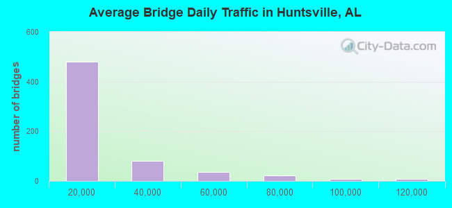
- 10,240,811Total average daily traffic
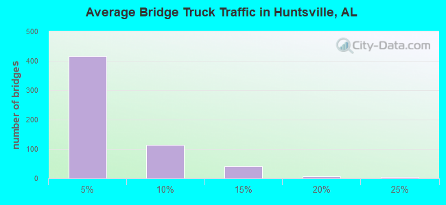
- 528,271Total average daily truck traffic
- National Bridge Inventory (NBI) Registered Bridges for Huntsville
- No street view available for this location
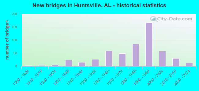
- New bridges - historical statistics
- 21900-1909
- 31910-1919
- 131920-1929
- 381930-1939
- 241940-1949
- 421950-1959
- 711960-1969
- 551970-1979
- 1011980-1989
- 1771990-1999
- 662000-2009
- 352010-2019
- 122020-2022
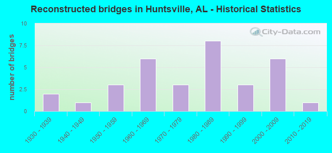
- Reconstructed bridges - Historical Statistics
- 21930-1939
- 11940-1949
- 31950-1959
- 61960-1969
- 31970-1979
- 81980-1989
- 31990-1999
- 62000-2009
- 12010-2019
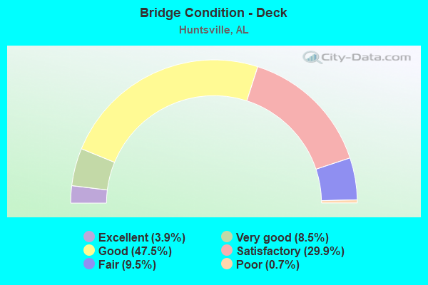
- Bridge Condition - Deck
- 3.9%Excellent
- 8.5%Very good
- 47.5%Good
- 29.9%Satisfactory
- 9.5%Fair
- 0.7%Poor
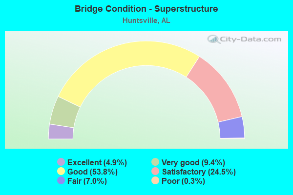
- Bridge Condition - Superstructure
- 4.9%Excellent
- 9.4%Very good
- 53.8%Good
- 24.5%Satisfactory
- 7.0%Fair
- 0.3%Poor
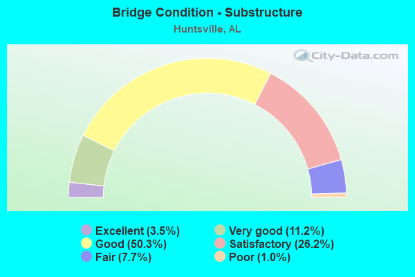
- Bridge Condition - Substructure
- 3.5%Excellent
- 11.2%Very good
- 50.3%Good
- 26.2%Satisfactory
- 7.7%Fair
- 1.0%Poor
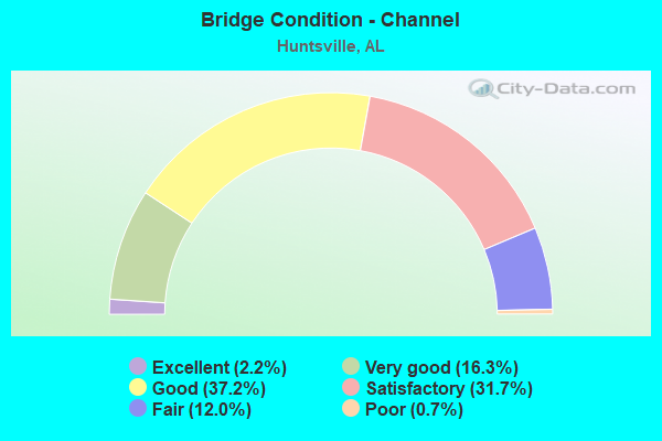
- Bridge Condition - Channel
- 2.2%Excellent
- 16.3%Very good
- 37.2%Good
- 31.7%Satisfactory
- 12.0%Fair
- 0.7%Poor
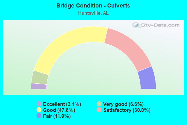
- Bridge Condition - Culverts
- 3.1%Excellent
- 6.6%Very good
- 47.6%Good
- 30.8%Satisfactory
- 11.9%Fair
Find on map >> Show street view
Structure Number: 11271, Location: TOWNSEND * FAGAN CREEK (Lat: 34.723333, Lng: -86.578333), Route carried "on" structure: City street , Year Built: 1974, Status: Open, Structure Length: 1.52m (4.99ft), Average Daily Traffic: 750 (year 2016), Truck Traffic: 1%, Average Future Daily Traffic: 1,050 (year 2036), Design Load: H 15, Features Intersected: FAGAN CREEK, Facility Carried by Structure: TOWNSEND SE
Minimum Vertical Clearance: 30+ m (98+ ft), Kilometerpoint: 0.010, Lanes on structure: 2, Owner: City or Municipal Highway Agency, Approaching Roadway Width: 9.1m (29.9ft), Material/Design: Concrete, Design/Construction: Culvert, Number Of Spans In Main Unit: 4, Length of Maximum Span: 3.7m (12.1ft), Curb or Sidewalk Widths: Left: 1.7m (5.6ft), Right: 1.7m (5.6ft), Curb-To-Curb Width: 9.1m (29.9ft), Out-to-Out Width: 13.7m (44.9ft)
Condition: Channel: Very good, Culverts: Good, Operating Rating: 63.8 metric tons, Method Used To Determine Operating Rating: Load Factor (LF), Inventory Rating: 38.3 metric tons, Method Used To Determine Inventory Rating: Load Factor (LF), Structural Evaluation: Better than present minimum criteria, Deck Geometry: Equal to present minimum criteria, Waterway Adequacy: Better than present minimum criteria, Approach Roadway Alignment: Better than present minimum criteria, Length Of Structure Improvement: 2.20m (7.22ft), Designated Inspection Frequency: Every 24 months, Inspection Date: November 2020, Bridge Improvement Cost: $584,000, Roadway Improvement Cost: $58,000, Total Project Cost: $642,000 ( Estimate for 2022)
Find on map >> Show street view
Structure Number: 11274, Location: 1605 HERMITAGE ST SE (Lat: 34.726667, Lng: -86.560000), Route carried "on" structure: City street , Year Built: 1974, Status: Open, Structure Length: 0.82m (2.69ft), Average Daily Traffic: 2,660 (year 2017), Truck Traffic: 1%, Average Future Daily Traffic: 3,729 (year 2037), Design Load: H 15, Features Intersected: FAGAN CREEK, Facility Carried by Structure: HERMITAGE ST SE
Minimum Vertical Clearance: 30+ m (98+ ft), Kilometerpoint: 0.010, Lanes on structure: 2, Owner: City or Municipal Highway Agency, Approaching Roadway Width: 9.1m (29.9ft), Skew: 1 degrees, Material/Design: Concrete, Design/Construction: Culvert, Number Of Spans In Main Unit: 2, Length of Maximum Span: 4.0m (13.1ft), Curb or Sidewalk Widths: Left: 0.0m, Right: 1.2m (3.9ft), Curb-To-Curb Width: 9.1m (29.9ft), Out-to-Out Width: 15.0m (49.2ft)
Condition: Channel: Good, Culverts: Good, Operating Rating: 48.1 metric tons, Method Used To Determine Operating Rating: Load Factor (LF), Inventory Rating: 28.8 metric tons, Method Used To Determine Inventory Rating: Load Factor (LF), Structural Evaluation: Better than present minimum criteria, Deck Geometry: Meets minimum limits, Waterway Adequacy: Better than present minimum criteria, Approach Roadway Alignment: Better than present minimum criteria, Length Of Structure Improvement: 1.48m (4.86ft), Designated Inspection Frequency: Every 24 months, Inspection Date: August 2020, Bridge Improvement Cost: $470,000, Roadway Improvement Cost: $47,000, Total Project Cost: $517,000 ( Estimate for 2022)
Find on map >> Show street view
Structure Number: 1128, Location: GALLATIN * LOWE (Lat: 34.723889, Lng: -86.583278), Route carried "on" structure: City street , Year Built: 1974, Status: Open, Structure Length: 1.52m (4.99ft), Average Daily Traffic: 4,600 (year 2017), Truck Traffic: 1%, Average Future Daily Traffic: 6,440 (year 2037), Design Load: H 15, Features Intersected: FAGAN CREEK, Facility Carried by Structure: GALLATIN
Minimum Vertical Clearance: 30+ m (98+ ft), Kilometerpoint: 0.010, Lanes on structure: 4, Owner: City or Municipal Highway Agency, Approaching Roadway Width: 15.8m (51.8ft), Skew: 1 degrees, Material/Design: Concrete, Design/Construction: Culvert, Number Of Spans In Main Unit: 4, Length of Maximum Span: 3.7m (12.1ft), Curb or Sidewalk Widths: Left: 1.7m (5.6ft), Right: 1.7m (5.6ft), Curb-To-Curb Width: 16.0m (52.5ft), Out-to-Out Width: 20.0m (65.6ft)
Condition: Channel: Good, Culverts: Satisfactory, Operating Rating: 61.3 metric tons, Method Used To Determine Operating Rating: Load Factor (LF), Inventory Rating: 36.7 metric tons, Method Used To Determine Inventory Rating: Load Factor (LF), Structural Evaluation: Equal to present minimum criteria, Deck Geometry: Meets minimum limits, Waterway Adequacy: Better than present minimum criteria, Approach Roadway Alignment: Better than present minimum criteria, Length Of Structure Improvement: 2.20m (7.22ft), Designated Inspection Frequency: Every 24 months, Inspection Date: November 2020, Bridge Improvement Cost: $2,224,000, Roadway Improvement Cost: $222,000, Total Project Cost: $2,446,000 ( Estimate for 2022)
Find on map >> Show street view
Structure Number: 11281, Location: MADISON * LOWE (Lat: 34.725000, Lng: -86.581667), Route carried "on" structure: City street , Year Built: 1974, Status: Open, Structure Length: 1.52m (4.99ft), Average Daily Traffic: 8,200 (year 2018), Truck Traffic: 1%, Average Future Daily Traffic: 11,480 (year 2038), Design Load: H 15, Features Intersected: FAGAN CREEK, Facility Carried by Structure: MADISON
Minimum Vertical Clearance: 30+ m (98+ ft), Kilometerpoint: 0.010, Lanes on structure: 4, Owner: City or Municipal Highway Agency, Approaching Roadway Width: 17.7m (58.1ft), Skew: 1 degrees, Material/Design: Concrete, Design/Construction: Culvert, Number Of Spans In Main Unit: 4, Length of Maximum Span: 3.7m (12.1ft), Curb or Sidewalk Widths: Left: 1.7m (5.6ft), Right: 1.7m (5.6ft), Curb-To-Curb Width: 17.7m (58.1ft), Out-to-Out Width: 21.3m (69.9ft)
Condition: Channel: Very good, Culverts: Very good, Operating Rating: 88.9 metric tons, Method Used To Determine Operating Rating: Load Factor (LF), Inventory Rating: 67.0 metric tons, Method Used To Determine Inventory Rating: Load Factor (LF), Structural Evaluation: Equal to present desirable criteria, Deck Geometry: Somewhat better than minimum adequacy, Waterway Adequacy: Better than present minimum criteria, Approach Roadway Alignment: Better than present minimum criteria, Length Of Structure Improvement: 2.20m (7.22ft), Designated Inspection Frequency: Every 24 months, Inspection Date: August 2020, Bridge Improvement Cost: $1,690,000, Roadway Improvement Cost: $169,000, Total Project Cost: $1,859,000 ( Estimate for 2022)
Find on map >> Show street view
Structure Number: 11283, Location: FRANKLIN * LOWE (Lat: 34.724600, Lng: -86.580000), Route carried "on" structure: City street , Year Built: 1974, Status: Open, Structure Length: 1.52m (4.99ft), Average Daily Traffic: 3,300 (year 2018), Truck Traffic: 1%, Average Future Daily Traffic: 4,620 (year 2038), Design Load: H 15, Features Intersected: FAGAN CREEK, Facility Carried by Structure: FRANKLIN ST
Minimum Vertical Clearance: 7.56m (24.80ft), Kilometerpoint: 0.010, Lanes on structure: 3, Owner: City or Municipal Highway Agency, Approaching Roadway Width: 12.2m (40.0ft), Material/Design: Concrete, Design/Construction: Culvert, Number Of Spans In Main Unit: 4, Length of Maximum Span: 3.7m (12.1ft), Curb or Sidewalk Widths: Left: 2.0m (6.6ft), Right: 2.0m (6.6ft), Curb-To-Curb Width: 12.3m (40.4ft), Out-to-Out Width: 16.5m (54.1ft)
Condition: Channel: Very good, Culverts: Good, Operating Rating: 54.7 metric tons, Method Used To Determine Operating Rating: Load Factor (LF), Inventory Rating: 32.7 metric tons, Method Used To Determine Inventory Rating: Load Factor (LF), Structural Evaluation: Better than present minimum criteria, Deck Geometry: Meets minimum limits, Waterway Adequacy: Better than present minimum criteria, Approach Roadway Alignment: Better than present minimum criteria, Length Of Structure Improvement: 2.20m (7.22ft), Designated Inspection Frequency: Every 24 months, Inspection Date: August 2020, Bridge Improvement Cost: $966,000, Roadway Improvement Cost: $97,000, Total Project Cost: $1,063,000 ( Estimate for 2022)
Find on map >> Show street view
Structure Number: 11286, Location: RISON * DEMENT (Lat: 34.746667, Lng: -86.578333), Route carried "on" structure: City street , Year Built: 1974, Status: Open, Structure Length: 1.04m (3.41ft), Average Daily Traffic: 150 (year 2017), Truck Traffic: 1%, Average Future Daily Traffic: 210 (year 2037), Design Load: H 15, Features Intersected: DALLAS CREEK, Facility Carried by Structure: DEMENT
Minimum Vertical Clearance: 30+ m (98+ ft), Kilometerpoint: 0.010, Lanes on structure: 2, Owner: City or Municipal Highway Agency, Approaching Roadway Width: 8.2m (26.9ft), Material/Design: Concrete, Design/Construction: Culvert, Number Of Spans In Main Unit: 4, Length of Maximum Span: 2.4m (7.9ft), Curb or Sidewalk Widths: Left: 1.2m (3.9ft), Right: 1.2m (3.9ft), Curb-To-Curb Width: 9.2m (30.2ft), Out-to-Out Width: 12.2m (40.0ft)
Condition: Channel: Very good, Culverts: Good, Operating Rating: 58.6 metric tons, Method Used To Determine Operating Rating: Load Factor (LF), Inventory Rating: 35.1 metric tons, Method Used To Determine Inventory Rating: Load Factor (LF), Structural Evaluation: Better than present minimum criteria, Deck Geometry: Equal to present minimum criteria, Waterway Adequacy: Better than present minimum criteria, Approach Roadway Alignment: Better than present minimum criteria, Length Of Structure Improvement: 1.71m (5.61ft), Designated Inspection Frequency: Every 24 months, Inspection Date: December 2020, Bridge Improvement Cost: $396,000, Roadway Improvement Cost: $40,000, Total Project Cost: $436,000 ( Estimate for 2022)
Find on map >> Show street view
Structure Number: 11289, Location: 2305 MEDARIS RD (Lat: 34.787594, Lng: -86.597042), Route carried "on" structure: City street , Year Built: 1974, Status: Open, Structure Length: 1.16m (3.81ft), Average Daily Traffic: 4,180 (year 2017), Truck Traffic: 1%, Average Future Daily Traffic: 5,852 (year 2037), Design Load: H 15, Features Intersected: PINHOOK CREEK, Facility Carried by Structure: MEDARIS RD
Minimum Vertical Clearance: 30+ m (98+ ft), Kilometerpoint: 0.010, Lanes on structure: 2, Owner: City or Municipal Highway Agency, Approaching Roadway Width: 8.5m (27.9ft), Skew: 3 degrees, Material/Design: Concrete, Design/Construction: Culvert, Number Of Spans In Main Unit: 3, Length of Maximum Span: 3.7m (12.1ft), Curb-To-Curb Width: 14.8m (48.6ft), Out-to-Out Width: 14.8m (48.6ft)
Condition: Channel: Good, Culverts: Good, Operating Rating: 79.5 metric tons, Method Used To Determine Operating Rating: Load Factor (LF), Inventory Rating: 47.7 metric tons, Method Used To Determine Inventory Rating: Load Factor (LF), Structural Evaluation: Better than present minimum criteria, Deck Geometry: Superior to present desirable criteria, Waterway Adequacy: Better than present minimum criteria, Approach Roadway Alignment: Equal to present minimum criteria, Length Of Structure Improvement: 1.84m (6.04ft), Designated Inspection Frequency: Every 24 months, Inspection Date: March 2021, Bridge Improvement Cost: $604,000, Roadway Improvement Cost: $60,000, Total Project Cost: $664,000 ( Estimate for 2022)
Find on map >> Show street view
Structure Number: 11504, Location: 2502 MEDARIS RD (Lat: 34.787525, Lng: -86.591928), Route carried "on" structure: City street , Year Built: 1975, Status: Open, Structure Length: 0.98m (3.22ft), Average Daily Traffic: 4,225 (year 2017), Truck Traffic: 1%, Average Future Daily Traffic: 5,915 (year 2037), Design Load: H 15, Features Intersected: BLUE SPRING BRANCH, Facility Carried by Structure: MEDARIS RD
Minimum Vertical Clearance: 30+ m (98+ ft), Kilometerpoint: 0.010, Lanes on structure: 2, Owner: City or Municipal Highway Agency, Approaching Roadway Width: 8.8m (28.9ft), Skew: 1 degrees, Material/Design: Concrete, Design/Construction: Culvert, Number Of Spans In Main Unit: 3, Length of Maximum Span: 3.0m (9.8ft), Curb or Sidewalk Widths: Left: 1.2m (3.9ft), Right: 0.0m, Curb-To-Curb Width: 8.8m (28.9ft), Out-to-Out Width: 15.3m (50.2ft)
Condition: Channel: Satisfactory, Culverts: Good, Operating Rating: 88.9 metric tons, Method Used To Determine Operating Rating: Load Factor (LF), Inventory Rating: 68.8 metric tons, Method Used To Determine Inventory Rating: Load Factor (LF), Structural Evaluation: Better than present minimum criteria, Deck Geometry: Meets minimum limits, Waterway Adequacy: Better than present minimum criteria, Approach Roadway Alignment: Better than present minimum criteria, Length Of Structure Improvement: 1.65m (5.41ft), Designated Inspection Frequency: Every 24 months, Inspection Date: March 2020, Bridge Improvement Cost: $477,000, Roadway Improvement Cost: $48,000, Total Project Cost: $525,000 ( Estimate for 2022)
Find on map >> Show street view
Structure Number: 11672, Location: BOB WALLACE AVE/* SR53 (Lat: 34.710672, Lng: -86.590322), Route carried "on" structure: US 231, Year Built: 1976, Status: Open, Structure Length: 10.61m (34.81ft), Average Daily Traffic: 102,157 (year 2019), Truck Traffic: 3%, Average Future Daily Traffic: 143,020 (year 2039), Design Load: HS 20, Features Intersected: BOB WALLACE AVE
Minimum Vertical Clearance: 30+ m (98+ ft), Kilometerpoint: 508.749, Lanes on structure: 6, Lanes under structure: 6, Base Highway Network: Yes, Owner: State Highway Agency, Approaching Roadway Width: 12.8m (42.0ft), Skew: 30 degrees, Material/Design: Steel, Design/Construction: Stringer/Multi-beam, Number Of Spans In Main Unit: 3, Length of Maximum Span: 35.4m (116.1ft), Curb or Sidewalk Widths: Left: 0.2m (0.7ft), Right: 0.2m (0.7ft), Curb-To-Curb Width: 24.8m (81.4ft), Out-to-Out Width: 27.1m (88.9ft)
Condition: Deck: Satisfactory, Superstructure: Good, Substructure: Good, Operating Rating: 66.5 metric tons, Method Used To Determine Operating Rating: Load Factor (LF), Inventory Rating: 39.8 metric tons, Method Used To Determine Inventory Rating: Load Factor (LF), Structural Evaluation: Better than present minimum criteria, Deck Geometry: Somewhat better than minimum adequacy, Underclear: Equal to present minimum criteria, Approach Roadway Alignment: Better than present minimum criteria, Length Of Structure Improvement: 11.52m (37.80ft), Designated Inspection Frequency: Every 24 months, Inspection Date: October 2020, Bridge Improvement Cost: $6,949,000, Roadway Improvement Cost: $695,000, Total Project Cost: $7,644,000 ( Estimate for 2022), Deck Structure Type: Concrete Cast-file-Place
Find on map >> Show street view
Structure Number: 1178, Location: 1.4MI N JCT CO 339 *340 (Lat: 33.221375, Lng: -86.778992), Route carried "on" structure: County highway , Year Built: 1977, Status: Posted for load, Structure Length: 0.98m (3.22ft), Average Daily Traffic: 1,500 (year 2020), Truck Traffic: 1%, Average Future Daily Traffic: 2,100 (year 2040), Features Intersected: QUARRY ROAD, Facility Carried by Structure: MASSEY RD-CO339EX
Minimum Vertical Clearance: 30+ m (98+ ft), Kilometerpoint: 0.010, Lanes on structure: 2, Lanes under structure: 1, Owner: County Highway Agency, Approaching Roadway Width: 6.7m (22.0ft), Material/Design: Steel, Design/Construction: Stringer/Multi-beam, Number Of Spans In Main Unit: 1, Length of Maximum Span: 9.8m (32.2ft), Curb-To-Curb Width: 8.2m (26.9ft), Out-to-Out Width: 8.4m (27.6ft)
Condition: Deck: Satisfactory, Superstructure: Fair, Substructure: Fair, Operating Rating: 41.6 metric tons, Method Used To Determine Operating Rating: Load Factor (LF), Inventory Rating: 24.9 metric tons, Method Used To Determine Inventory Rating: Load Factor (LF), Structural Evaluation: Somewhat better than minimum adequacy, Deck Geometry: Meets minimum limits, Approach Roadway Alignment: Equal to present minimum criteria, Bridge Posting: Required (Relationship of Operating Rating to Maximum Legal Load: 0.1 - 9.9% below), Length Of Structure Improvement: 1.65m (5.41ft), Designated Inspection Frequency: Every 24 months, Other Special Inspection Frequency: Every 12 months, Inspection Date: June 2020, Other Special Inspection Date: June 2021, Bridge Improvement Cost: $306,000, Roadway Improvement Cost: $31,000, Total Project Cost: $337,000 ( Estimate for 2022), Deck Structure Type: Wood or Timber, Wearing Surface/Protective System: Wearing Surface: Wood or Timber
Find on map >> Show street view
Structure Number: 11783, Location: JCT GOVERNORS DR * US231S (Lat: 34.720850, Lng: -86.592967), Route carried "on" structure: ServiceUS 231, Year Built: 1977, Status: Open, Structure Length: 6.25m (20.51ft), Average Daily Traffic: 7,809 (year 2019), Truck Traffic: 2%, Average Future Daily Traffic: 10,933 (year 2039), Design Load: HS 20, Features Intersected: HUNTSVILLE SPRING BRANCH
Minimum Vertical Clearance: 30+ m (98+ ft), Kilometerpoint: 537.130, Lanes on structure: 3, Base Highway Network: Yes, Owner: State Highway Agency, Approaching Roadway Width: 11.9m (39.0ft), Skew: 3 degrees, Material/Design: Prestressed concrete, Design/Construction: Stringer/Multi-beam, Number Of Spans In Main Unit: 6, Length of Maximum Span: 10.4m (34.1ft), Curb or Sidewalk Widths: Left: 0.0m, Right: 1.5m (4.9ft), Curb-To-Curb Width: 11.9m (39.0ft), Out-to-Out Width: 14.3m (46.9ft)
Condition: Deck: Good, Superstructure: Good, Substructure: Satisfactory, Channel: Satisfactory, Operating Rating: 66.5 metric tons, Method Used To Determine Operating Rating: Load Factor (LF), Inventory Rating: 41.1 metric tons, Method Used To Determine Inventory Rating: Load Factor (LF), Structural Evaluation: Equal to present minimum criteria, Deck Geometry: High priority of corrective action, Waterway Adequacy: Equal to present minimum criteria, Approach Roadway Alignment: Equal to present minimum criteria, Length Of Structure Improvement: 7.29m (23.92ft), Designated Inspection Frequency: Every 24 months, Inspection Date: December 2020, Bridge Improvement Cost: $2,300,000, Roadway Improvement Cost: $230,000, Total Project Cost: $2,530,000 ( Estimate for 2022), Deck Structure Type: Concrete Cast-file-Place
Find on map >> Show street view
Structure Number: 11784, Location: JCT GOVERNORS DR * US231N (Lat: 34.720403, Lng: -86.593239), Route carried "on" structure: ServiceUS 231, Year Built: 1977, Status: Open, Structure Length: 6.25m (20.51ft), Average Daily Traffic: 13,582 (year 2019), Truck Traffic: 4%, Average Future Daily Traffic: 19,015 (year 2039), Design Load: HS 20, Features Intersected: HUNTSVILLE SPRING BRANCH
Minimum Vertical Clearance: 30+ m (98+ ft), Kilometerpoint: 537.130, Lanes on structure: 3, Base Highway Network: Yes, Owner: State Highway Agency, Approaching Roadway Width: 11.9m (39.0ft), Skew: 3 degrees, Material/Design: Prestressed concrete, Design/Construction: Stringer/Multi-beam, Number Of Spans In Main Unit: 6, Length of Maximum Span: 10.4m (34.1ft), Curb or Sidewalk Widths: Left: 1.5m (4.9ft), Right: 0.0m, Curb-To-Curb Width: 11.9m (39.0ft), Out-to-Out Width: 14.3m (46.9ft)
Condition: Deck: Good, Superstructure: Satisfactory, Substructure: Satisfactory, Channel: Satisfactory, Operating Rating: 54.2 metric tons, Method Used To Determine Operating Rating: Load Factor (LF), Inventory Rating: 48.1 metric tons, Method Used To Determine Inventory Rating: Load Factor (LF), Structural Evaluation: Equal to present minimum criteria, Deck Geometry: High priority of corrective action, Waterway Adequacy: Equal to present minimum criteria, Approach Roadway Alignment: Equal to present minimum criteria, Length Of Structure Improvement: 7.29m (23.92ft), Designated Inspection Frequency: Every 24 months, Inspection Date: December 2020, Bridge Improvement Cost: $2,300,000, Roadway Improvement Cost: $230,000, Total Project Cost: $2,530,000 ( Estimate for 2022), Deck Structure Type: Concrete Cast-file-Place
Find on map >> Show street view
Structure Number: 1179, Location: .5 MI N ANTIOCH ON F.A.S6 (Lat: 32.948136, Lng: -86.980125), Route carried "on" structure: County highway 6, Year Built: 1977, Status: Open, Structure Length: 4.15m (13.62ft), Average Daily Traffic: 60 (year 1989), Average Future Daily Traffic: 90 (year 2030), Design Load: H 20, Features Intersected: COPPERAS CREEK
Minimum Vertical Clearance: 30+ m (98+ ft), Kilometerpoint: 0.010, Lanes on structure: 2, Owner: County Highway Agency, Approaching Roadway Width: 8.5m (27.9ft), Material/Design: Concrete, Design/Construction: Tee Beam, Number Of Spans In Main Unit: 4, Length of Maximum Span: 10.4m (34.1ft), Curb-To-Curb Width: 7.3m (24.0ft), Out-to-Out Width: 8.2m (26.9ft)
Condition: Deck: Good, Superstructure: Good, Substructure: Satisfactory, Channel: Satisfactory, Operating Rating: 45.1 metric tons, Method Used To Determine Operating Rating: Load Factor (LF), Inventory Rating: 27.1 metric tons, Method Used To Determine Inventory Rating: Load Factor (LF), Structural Evaluation: Equal to present minimum criteria, Deck Geometry: Equal to present minimum criteria, Waterway Adequacy: Better than present minimum criteria, Approach Roadway Alignment: Better than present minimum criteria, Length Of Structure Improvement: 5.12m (16.80ft), Designated Inspection Frequency: Every 24 months, Inspection Date: December 2020, Bridge Improvement Cost: $912,000, Roadway Improvement Cost: $91,000, Total Project Cost: $1,003,000 ( Estimate for 2022), Deck Structure Type: Concrete Cast-file-Place
Find on map >> Show street view
Structure Number: 11829, Location: 0.3 MI S US 431 (Lat: 34.720000, Lng: -86.590000), Route carried "on" structure: US 231, Year Built: 1977, Status: Open, Structure Length: 0.70m (2.30ft), Average Daily Traffic: 104,983 (year 2020), Truck Traffic: 3%, Average Future Daily Traffic: 146,976 (year 2040), Design Load: HS 20, Features Intersected: STREAM, Facility Carried by Structure: SR 53
Minimum Vertical Clearance: 30+ m (98+ ft), Kilometerpoint: 509.393, Lanes on structure: 10, Base Highway Network: Yes, Owner: State Highway Agency, Approaching Roadway Width: 36.6m (120.1ft), Skew: 24 degrees, Material/Design: Concrete, Design/Construction: Culvert, Number Of Spans In Main Unit: 3, Length of Maximum Span: 2.1m (6.9ft)
Condition: Channel: Good, Culverts: Satisfactory, Operating Rating: 34.7 metric tons, Method Used To Determine Operating Rating: Load Factor (LF), Inventory Rating: 20.9 metric tons, Method Used To Determine Inventory Rating: Load Factor (LF), Structural Evaluation: Somewhat better than minimum adequacy, Waterway Adequacy: Better than present minimum criteria, Approach Roadway Alignment: Equal to present desirable criteria, Length Of Structure Improvement: 1.34m (4.40ft), Designated Inspection Frequency: Every 24 months, Inspection Date: January 2022, Bridge Improvement Cost: $2,033,000, Roadway Improvement Cost: $203,000, Total Project Cost: $2,236,000 ( Estimate for 2022), Wearing Surface/Protective System: Wearing Surface: Bituminous
Find on map >> Show street view
Structure Number: 1192, Location: 1 MI E JCT US72 * SR 255 (Lat: 34.736667, Lng: -86.653333), Route carried "on" structure: US 72, Year Built: 1990, Status: Open, Structure Length: 1.28m (4.20ft), Average Daily Traffic: 44,635 (year 2018), Truck Traffic: 4%, Average Future Daily Traffic: 62,489 (year 2038), Design Load: HS 20, Features Intersected: BRANCH
Minimum Vertical Clearance: 30+ m (98+ ft), Kilometerpoint: 151.148, Lanes on structure: 6, Owner: State Highway Agency, Approaching Roadway Width: 21.9m (71.9ft), Skew: 10 degrees, Material/Design: Concrete, Design/Construction: Culvert, Number Of Spans In Main Unit: 4, Length of Maximum Span: 3.0m (9.8ft)
Condition: Channel: Very good, Culverts: Good, Operating Rating: 88.9 metric tons, Method Used To Determine Operating Rating: Load Factor (LF), Inventory Rating: 71.4 metric tons, Method Used To Determine Inventory Rating: Load Factor (LF), Structural Evaluation: Better than present minimum criteria, Waterway Adequacy: Equal to present minimum criteria, Approach Roadway Alignment: Equal to present desirable criteria, Length Of Structure Improvement: 1.95m (6.40ft), Designated Inspection Frequency: Every 24 months, Inspection Date: June 2020, Bridge Improvement Cost: $1,128,000, Roadway Improvement Cost: $113,000, Total Project Cost: $1,241,000 ( Estimate for 2022), Wearing Surface/Protective System: Wearing Surface: Bituminous
Find on map >> Show street view
Structure Number: 11957, Location: JCT GOVERNORS DR * US 231 (Lat: 34.718333, Lng: -86.593333), Route carried "on" structure: US 231, Year Built: 1978, Status: Open, Structure Length: 22.16m (72.70ft), Average Daily Traffic: 110,258 (year 2019), Truck Traffic: 3%, Average Future Daily Traffic: 154,361 (year 2039), Design Load: HS 20, Features Intersected: GOVERNOR'S DR * BRANCH
Minimum Vertical Clearance: 30+ m (98+ ft), Kilometerpoint: 536.985, Lanes on structure: 4, Lanes under structure: 4, Base Highway Network: Yes, Owner: State Highway Agency, Approaching Roadway Width: 28.1m (92.2ft), Skew: 23 degrees, Material/Design: Steel, Design/Construction: Stringer/Multi-beam, Number Of Spans In Main Unit: 4, Number Of Approach Spans: 8, Length of Maximum Span: 43.6m (143.0ft), Curb-To-Curb Width: 27.3m (89.6ft), Out-to-Out Width: 28.1m (92.2ft)
Condition: Deck: Fair, Superstructure: Satisfactory, Substructure: Satisfactory, Channel: Satisfactory, Operating Rating: 57.6 metric tons, Method Used To Determine Operating Rating: Load Factor (LF), Inventory Rating: 34.6 metric tons, Method Used To Determine Inventory Rating: Load Factor (LF), Structural Evaluation: Equal to present minimum criteria, Deck Geometry: Superior to present desirable criteria, Underclear: Meets minimum limits, Waterway Adequacy: Equal to present minimum criteria, Approach Roadway Alignment: Better than present minimum criteria, Length Of Structure Improvement: 22.16m (72.70ft), Designated Inspection Frequency: Every 24 months, Inspection Date: October 2020, Bridge Improvement Cost: $13,979,000, Roadway Improvement Cost: $1,398,000, Total Project Cost: $15,377,000 ( Estimate for 2022), Deck Structure Type: Concrete Cast-file-Place
Find on map >> Show street view
Structure Number: 11997, Location: 1.1 MI E JCT I 65 (Lat: 34.627633, Lng: -86.890497), Route carried "on" structure: County highway 71A, Year Built: 1978, Status: Open, Structure Length: 6.25m (20.51ft), Average Daily Traffic: 200 (year 2014), Truck Traffic: 1%, Average Future Daily Traffic: 300 (year 2034), Design Load: HS 20, Features Intersected: PINEY CREEK RELIEF
Minimum Vertical Clearance: 30+ m (98+ ft), Kilometerpoint: 0.000, Lanes on structure: 2, Owner: County Highway Agency, Approaching Roadway Width: 12.8m (42.0ft), Skew: 10 degrees, Material/Design: Prestressed concrete continuous, Design/Construction: Stringer/Multi-beam, Number Of Spans In Main Unit: 5, Length of Maximum Span: 12.5m (41.0ft), Curb or Sidewalk Widths: Left: 0.4m (1.3ft), Right: 0.4m (1.3ft), Curb-To-Curb Width: 12.2m (40.0ft), Out-to-Out Width: 13.0m (42.7ft)
Condition: Deck: Good, Superstructure: Very good, Substructure: Very good, Channel: Good, Operating Rating: 63.9 metric tons, Method Used To Determine Operating Rating: Load Factor (LF), Inventory Rating: 33.6 metric tons, Method Used To Determine Inventory Rating: Load Factor (LF), Structural Evaluation: Equal to present desirable criteria, Deck Geometry: Better than present minimum criteria, Waterway Adequacy: Better than present minimum criteria, Approach Roadway Alignment: Equal to present desirable criteria, Length Of Structure Improvement: 7.29m (23.92ft), Designated Inspection Frequency: Every 24 months, Inspection Date: October 2020, Bridge Improvement Cost: $2,100,000, Roadway Improvement Cost: $210,000, Total Project Cost: $2,310,000 ( Estimate for 2022), Deck Structure Type: Concrete Cast-file-Place
Find on map >> Show street view
Structure Number: 12057, Location: 2804 WINCHESTER RD (Lat: 34.792983, Lng: -86.605528), Route carried "on" structure: City street , Year Built: 1978, Status: Open, Structure Length: 1.04m (3.41ft), Average Daily Traffic: 14,000 (year 2015), Truck Traffic: 1%, Average Future Daily Traffic: 19,600 (year 2035), Design Load: H 15, Features Intersected: PINHOOK CREEK, Facility Carried by Structure: WINCHESTER RD
Minimum Vertical Clearance: 30+ m (98+ ft), Kilometerpoint: 0.010, Lanes on structure: 5, Owner: City or Municipal Highway Agency, Approaching Roadway Width: 16.5m (54.1ft), Skew: 3 degrees, Material/Design: Concrete, Design/Construction: Culvert, Number Of Spans In Main Unit: 3, Length of Maximum Span: 3.4m (11.2ft), Curb or Sidewalk Widths: Left: 1.9m (6.2ft), Right: 1.9m (6.2ft), Curb-To-Curb Width: 16.5m (54.1ft), Out-to-Out Width: 20.8m (68.2ft)
Condition: Channel: Satisfactory, Culverts: Good, Operating Rating: 56.8 metric tons, Method Used To Determine Operating Rating: Load Factor (LF), Inventory Rating: 34.0 metric tons, Method Used To Determine Inventory Rating: Load Factor (LF), Structural Evaluation: Better than present minimum criteria, Deck Geometry: High priority of replacement, Waterway Adequacy: Better than present minimum criteria, Approach Roadway Alignment: Better than present minimum criteria, Length Of Structure Improvement: 1.71m (5.61ft), Designated Inspection Frequency: Every 24 months, Inspection Date: August 2020, Bridge Improvement Cost: $732,000, Roadway Improvement Cost: $73,000, Total Project Cost: $805,000 ( Estimate for 2022)
Find on map >> Show street view
Structure Number: 12416, Location: BROOKMANOR * BROGLAN (Lat: 34.732750, Lng: -86.611444), Route carried "on" structure: City street , Year Built: 1980, Status: Open, Structure Length: 1.77m (5.81ft), Average Daily Traffic: 1,500 (year 2017), Truck Traffic: 1%, Average Future Daily Traffic: 2,100 (year 2037), Design Load: H 15, Features Intersected: BROGLAN BRANCH, Facility Carried by Structure: BROOKMANOR
Minimum Vertical Clearance: 30+ m (98+ ft), Kilometerpoint: 0.010, Lanes on structure: 2, Owner: City or Municipal Highway Agency, Approaching Roadway Width: 9.1m (29.9ft), Material/Design: Concrete, Design/Construction: Culvert, Number Of Spans In Main Unit: 4, Length of Maximum Span: 4.6m (15.1ft), Curb or Sidewalk Widths: Left: 1.6m (5.2ft), Right: 1.6m (5.2ft), Curb-To-Curb Width: 9.1m (29.9ft), Out-to-Out Width: 12.8m (42.0ft)
Condition: Channel: Satisfactory, Culverts: Good, Operating Rating: 44.0 metric tons, Method Used To Determine Operating Rating: Load Factor (LF), Inventory Rating: 26.4 metric tons, Method Used To Determine Inventory Rating: Load Factor (LF), Structural Evaluation: Equal to present minimum criteria, Deck Geometry: Somewhat better than minimum adequacy, Waterway Adequacy: Better than present minimum criteria, Approach Roadway Alignment: Better than present minimum criteria, Length Of Structure Improvement: 2.48m (8.14ft), Designated Inspection Frequency: Every 24 months, Inspection Date: November 2020, Bridge Improvement Cost: $586,000, Roadway Improvement Cost: $59,000, Total Project Cost: $645,000 ( Estimate for 2022)
Find on map >> Show street view
Structure Number: 12617, Location: 305 N PLYMOUTH RD (Lat: 34.767800, Lng: -86.575600), Route carried "on" structure: City street , Year Built: 1981, Status: Open, Structure Length: 0.67m (2.20ft), Average Daily Traffic: 6,400 (year 2019), Truck Traffic: 1%, Average Future Daily Traffic: 8,960 (year 2039), Design Load: HS 20, Features Intersected: BRANCH, Facility Carried by Structure: NORTH PLYMOUTH RD
Minimum Vertical Clearance: 30+ m (98+ ft), Kilometerpoint: 0.010, Lanes on structure: 2, Owner: City or Municipal Highway Agency, Approaching Roadway Width: 8.8m (28.9ft), Material/Design: Concrete, Design/Construction: Culvert, Number Of Spans In Main Unit: 2, Length of Maximum Span: 3.0m (9.8ft), Curb or Sidewalk Widths: Left: 1.2m (3.9ft), Right: 0.0m
Condition: Channel: Good, Culverts: Good, Operating Rating: 59.0 metric tons, Method Used To Determine Operating Rating: Load Factor (LF), Inventory Rating: 35.3 metric tons, Method Used To Determine Inventory Rating: Load Factor (LF), Structural Evaluation: Better than present minimum criteria, Waterway Adequacy: Better than present minimum criteria, Approach Roadway Alignment: Somewhat better than minimum adequacy, Length Of Structure Improvement: 1.30m (4.27ft), Designated Inspection Frequency: Every 24 months, Inspection Date: August 2020, Bridge Improvement Cost: $405,000, Roadway Improvement Cost: $41,000, Total Project Cost: $446,000 ( Estimate for 2022)
Find on map >> Show street view
Structure Number: 12618, Location: 3205 MERIDIAN ST (Lat: 34.766667, Lng: -86.571667), Route carried "on" structure: City street , Year Built: 1981, Status: Open, Structure Length: 0.67m (2.20ft), Average Daily Traffic: 17,200 (year 2019), Truck Traffic: 2%, Average Future Daily Traffic: 24,080 (year 2039), Design Load: HS 20, Features Intersected: STREAM, Facility Carried by Structure: MERIDIAN ST
Minimum Vertical Clearance: 30+ m (98+ ft), Kilometerpoint: 0.010, Lanes on structure: 4, Owner: City or Municipal Highway Agency, Approaching Roadway Width: 15.8m (51.8ft), Material/Design: Concrete, Design/Construction: Culvert, Number Of Spans In Main Unit: 2, Length of Maximum Span: 3.0m (9.8ft), Curb or Sidewalk Widths: Left: 1.5m (4.9ft), Right: 1.5m (4.9ft)
Condition: Channel: Good, Culverts: Good, Operating Rating: 56.8 metric tons, Method Used To Determine Operating Rating: Load Factor (LF), Inventory Rating: 34.0 metric tons, Method Used To Determine Inventory Rating: Load Factor (LF), Structural Evaluation: Better than present minimum criteria, Waterway Adequacy: Better than present minimum criteria, Approach Roadway Alignment: Better than present minimum criteria, Length Of Structure Improvement: 1.30m (4.27ft), Designated Inspection Frequency: Every 24 months, Inspection Date: August 2020, Bridge Improvement Cost: $548,000, Roadway Improvement Cost: $55,000, Total Project Cost: $603,000 ( Estimate for 2022)
Find on map >> Show street view
Structure Number: 12666, Location: 1.5 MI SE JCT US HWY 431 (Lat: 34.822017, Lng: -86.553789), Route carried "on" structure: County highway 139, Year Built: 1940, Year Reconstructed: 1982, Status: Open, Structure Length: 0.73m (2.40ft), Average Daily Traffic: 750 (year 1992), Truck Traffic: 1%, Average Future Daily Traffic: 1,050 (year 2029), Design Load: H 15, Features Intersected: VALLEY VIEW BRANCH, Facility Carried by Structure: COUNTESS RD
Minimum Vertical Clearance: 30+ m (98+ ft), Kilometerpoint: 0.010, Lanes on structure: 2, Owner: County Highway Agency, Approaching Roadway Width: 8.5m (27.9ft), Material/Design: Masonry, Design/Construction: Culvert, Number Of Spans In Main Unit: 2, Length of Maximum Span: 3.0m (9.8ft), Curb-To-Curb Width: 8.7m (28.5ft), Out-to-Out Width: 9.1m (29.9ft)
Condition: Channel: Satisfactory, Culverts: Satisfactory, Operating Rating: 32.7 metric tons, Method Used To Determine Operating Rating: Field evaluation and documented engineering judgment, Inventory Rating: 23.6 metric tons, Method Used To Determine Inventory Rating: Field evaluation and documented engineering judgment, Structural Evaluation: Equal to present minimum criteria, Deck Geometry: Somewhat better than minimum adequacy, Waterway Adequacy: Equal to present minimum criteria, Approach Roadway Alignment: Somewhat better than minimum adequacy, Length Of Structure Improvement: 1.38m (4.53ft), Designated Inspection Frequency: Every 24 months, Inspection Date: January 2021, Bridge Improvement Cost: $238,000, Roadway Improvement Cost: $24,000, Total Project Cost: $262,000 ( Estimate for 2022)
Find on map >> Show street view
Structure Number: 12761, Location: 1010 MT GAP RD (Lat: 34.626667, Lng: -86.546667), Route carried "on" structure: City street , Year Built: 1982, Status: Open, Structure Length: 4.21m (13.81ft), Average Daily Traffic: 6,200 (year 2019), Truck Traffic: 1%, Average Future Daily Traffic: 8,680 (year 2039), Design Load: HS 20, Features Intersected: ALDRIDGE CREEK, Facility Carried by Structure: MOUNTAIN GAP ROA
Minimum Vertical Clearance: 30+ m (98+ ft), Kilometerpoint: 0.010, Lanes on structure: 4, Owner: City or Municipal Highway Agency, Approaching Roadway Width: 16.8m (55.1ft), Skew: 21 degrees, Material/Design: Prestressed concrete, Design/Construction: Stringer/Multi-beam, Number Of Spans In Main Unit: 3, Length of Maximum Span: 14.2m (46.6ft), Curb or Sidewalk Widths: Left: 2.0m (6.6ft), Right: 2.0m (6.6ft), Curb-To-Curb Width: 16.8m (55.1ft), Out-to-Out Width: 21.7m (71.2ft)
Condition: Deck: Good, Superstructure: Good, Substructure: Good, Channel: Good, Operating Rating: 60.9 metric tons, Method Used To Determine Operating Rating: Load Factor (LF), Inventory Rating: 35.9 metric tons, Method Used To Determine Inventory Rating: Load Factor (LF), Structural Evaluation: Better than present minimum criteria, Deck Geometry: Somewhat better than minimum adequacy, Waterway Adequacy: Equal to present desirable criteria, Approach Roadway Alignment: Superior to present desirable criteria, Length Of Structure Improvement: 5.18m (16.99ft), Designated Inspection Frequency: Every 24 months, Inspection Date: June 2020, Bridge Improvement Cost: $2,522,000, Roadway Improvement Cost: $252,000, Total Project Cost: $2,774,000 ( Estimate for 2022), Deck Structure Type: Concrete Cast-file-Place
Find on map >> Show street view
Structure Number: 12845, Location: BAILEY COVE* COUNTRY LANE (Lat: 34.636667, Lng: -86.538333), Route carried "on" structure: City street , Year Built: 1982, Status: Open, Structure Length: 0.70m (2.30ft), Average Daily Traffic: 16,200 (year 2019), Truck Traffic: 1%, Average Future Daily Traffic: 22,680 (year 2039), Design Load: HS 20, Features Intersected: STREAM, Facility Carried by Structure: BAILEY COVE ROAD
Minimum Vertical Clearance: 30+ m (98+ ft), Kilometerpoint: 0.010, Lanes on structure: 4, Owner: City or Municipal Highway Agency, Approaching Roadway Width: 15.8m (51.8ft), Skew: 21 degrees, Material/Design: Concrete, Design/Construction: Culvert, Number Of Spans In Main Unit: 3, Length of Maximum Span: 2.1m (6.9ft), Curb or Sidewalk Widths: Left: 1.2m (3.9ft), Right: 1.8m (5.9ft)
Condition: Channel: Satisfactory, Culverts: Good, Operating Rating: 88.9 metric tons, Method Used To Determine Operating Rating: Load Factor (LF), Inventory Rating: 75.9 metric tons, Method Used To Determine Inventory Rating: Load Factor (LF), Structural Evaluation: Better than present minimum criteria, Waterway Adequacy: Better than present minimum criteria, Approach Roadway Alignment: Better than present minimum criteria, Length Of Structure Improvement: 1.34m (4.40ft), Designated Inspection Frequency: Every 24 months, Inspection Date: May 2020, Bridge Improvement Cost: $703,000, Roadway Improvement Cost: $70,000, Total Project Cost: $773,000 ( Estimate for 2022)
Find on map >> Show street view
Structure Number: 12851, Location: 0.75 MI E OF CO RD 387 (Lat: 34.515139, Lng: -86.737350), Route carried "on" structure: County highway 459, Year Built: 1982, Status: Posted for load, Structure Length: 0.76m (2.49ft), Average Daily Traffic: 50 (year 1983), Average Future Daily Traffic: 134 (year 2041), Design Load: HS 15, Features Intersected: BLUE HOLE CREEK, Facility Carried by Structure: LEMOND ROAD
Minimum Vertical Clearance: 30+ m (98+ ft), Kilometerpoint: 0.010, Lanes on structure: 2, Owner: County Highway Agency, Approaching Roadway Width: 6.1m (20.0ft), Material/Design: Steel, Design/Construction: Stringer/Multi-beam, Number Of Spans In Main Unit: 1, Length of Maximum Span: 6.4m (21.0ft), Curb-To-Curb Width: 7.3m (24.0ft), Out-to-Out Width: 7.3m (24.0ft)
Condition: Deck: Good, Superstructure: Satisfactory, Substructure: Satisfactory, Channel: Satisfactory, Operating Rating: 42.5 metric tons, Method Used To Determine Operating Rating: Load Factor (LF), Inventory Rating: 25.3 metric tons, Method Used To Determine Inventory Rating: Load Factor (LF), Structural Evaluation: Equal to present minimum criteria, Deck Geometry: Equal to present minimum criteria, Waterway Adequacy: Better than present minimum criteria, Approach Roadway Alignment: Equal to present desirable criteria, Bridge Posting: Required (Relationship of Operating Rating to Maximum Legal Load: 10.0 - 19.9% below), Length Of Structure Improvement: 1.41m (4.63ft), Designated Inspection Frequency: Every 24 months, Other Special Inspection Frequency: Every 12 months, Inspection Date: September 2021, Other Special Inspection Date: September 2021, Bridge Improvement Cost: $232,000, Roadway Improvement Cost: $23,000, Total Project Cost: $255,000 ( Estimate for 2022), Deck Structure Type: Concrete Cast-file-Place, Wearing Surface/Protective System: Wearing Surface: Bituminous
Find on map >> Show street view
Structure Number: 12952, Location: HOLMES BETWEEN SANDERSON (Lat: 34.735000, Lng: -86.655000), Route carried "on" structure: City street , Year Built: 1983, Status: Open, Structure Length: 0.94m (3.08ft), Average Daily Traffic: 15,200 (year 2017), Truck Traffic: 1%, Average Future Daily Traffic: 21,280 (year 2037), Design Load: HS 20, Features Intersected: CREEK, Facility Carried by Structure: HOLMES ST
Minimum Vertical Clearance: 30+ m (98+ ft), Kilometerpoint: 0.010, Lanes on structure: 5, Owner: City or Municipal Highway Agency, Approaching Roadway Width: 16.2m (53.1ft), Skew: 20 degrees, Material/Design: Concrete, Design/Construction: Culvert, Number Of Spans In Main Unit: 3, Length of Maximum Span: 3.0m (9.8ft)
Condition: Channel: Good, Culverts: Good, Operating Rating: 70.9 metric tons, Method Used To Determine Operating Rating: Load Factor (LF), Inventory Rating: 42.5 metric tons, Method Used To Determine Inventory Rating: Load Factor (LF), Structural Evaluation: Better than present minimum criteria, Waterway Adequacy: Better than present minimum criteria, Approach Roadway Alignment: Better than present minimum criteria, Length Of Structure Improvement: 1.61m (5.28ft), Designated Inspection Frequency: Every 24 months, Inspection Date: June 2020, Bridge Improvement Cost: $594,000, Roadway Improvement Cost: $59,000, Total Project Cost: $653,000 ( Estimate for 2022)
Find on map >> Show street view
Structure Number: 13127, Location: BLUE SPRING ROAD (Lat: 34.788583, Lng: -86.593194), Route carried "on" structure: City street , Year Built: 1956, Year Reconstructed: 1984, Status: Open, Structure Length: 0.88m (2.89ft), Average Daily Traffic: 12,300 (year 2019), Truck Traffic: 2%, Average Future Daily Traffic: 17,220 (year 2039), Design Load: H 15, Features Intersected: PINHOOK CREEK, Facility Carried by Structure: BLUE SPRING RD
Minimum Vertical Clearance: 30+ m (98+ ft), Kilometerpoint: 0.010, Lanes on structure: 5, Owner: City or Municipal Highway Agency, Approaching Roadway Width: 15.8m (51.8ft), Skew: 3 degrees, Material/Design: Concrete, Design/Construction: Culvert, Number Of Spans In Main Unit: 2, Length of Maximum Span: 4.3m (14.1ft)
Condition: Channel: Good, Culverts: Satisfactory, Operating Rating: 88.9 metric tons, Method Used To Determine Operating Rating: Load Factor (LF), Inventory Rating: 69.3 metric tons, Method Used To Determine Inventory Rating: Load Factor (LF), Structural Evaluation: Equal to present minimum criteria, Waterway Adequacy: Better than present minimum criteria, Approach Roadway Alignment: Better than present minimum criteria, Length Of Structure Improvement: 1.55m (5.09ft), Designated Inspection Frequency: Every 24 months, Inspection Date: Febuary 2021, Bridge Improvement Cost: $813,000, Roadway Improvement Cost: $81,000, Total Project Cost: $894,000 ( Estimate for 2022)
Find on map >> Show street view
Structure Number: 13148, Location: 4100 BLUE SPRING RD (Lat: 34.776667, Lng: -86.598333), Route carried "on" structure: City street , Year Built: 1965, Year Reconstructed: 1984, Status: Open, Structure Length: 0.82m (2.69ft), Average Daily Traffic: 14,900 (year 2015), Truck Traffic: 1%, Average Future Daily Traffic: 20,860 (year 2035), Design Load: H 15, Features Intersected: PINHOOK CREEK, Facility Carried by Structure: BLUE SPRING RD
Minimum Vertical Clearance: 30+ m (98+ ft), Kilometerpoint: 0.010, Lanes on structure: 4, Owner: City or Municipal Highway Agency, Approaching Roadway Width: 15.8m (51.8ft), Skew: 4 degrees, Material/Design: Concrete, Design/Construction: Culvert, Number Of Spans In Main Unit: 2, Length of Maximum Span: 4.0m (13.1ft), Curb or Sidewalk Widths: Left: 1.8m (5.9ft), Right: 1.2m (3.9ft)
Condition: Channel: Satisfactory, Culverts: Good, Operating Rating: 52.1 metric tons, Method Used To Determine Operating Rating: Load Factor (LF), Inventory Rating: 31.2 metric tons, Method Used To Determine Inventory Rating: Load Factor (LF), Structural Evaluation: Better than present minimum criteria, Waterway Adequacy: Better than present minimum criteria, Approach Roadway Alignment: Better than present minimum criteria, Length Of Structure Improvement: 1.48m (4.86ft), Designated Inspection Frequency: Every 24 months, Inspection Date: April 2020, Bridge Improvement Cost: $837,000, Roadway Improvement Cost: $84,000, Total Project Cost: $921,000 ( Estimate for 2022)
Find on map >> Show street view
Structure Number: 13222, Location: 0.6 MI S FLINT RIVER (Lat: 34.631317, Lng: -86.461981), Route carried "on" structure: US 431, Year Built: 1984, Status: Open, Structure Length: 6.22m (20.41ft), Average Daily Traffic: 19,076 (year 2019), Truck Traffic: 5%, Average Future Daily Traffic: 26,706 (year 2039), Design Load: HS 20, Features Intersected: FLINT RIVER RELIEF #4
Minimum Vertical Clearance: 30+ m (98+ ft), Kilometerpoint: 519.590, Lanes on structure: 2, Owner: State Highway Agency, Approaching Roadway Width: 12.2m (40.0ft), Skew: 10 degrees, Material/Design: Prestressed concrete continuous, Design/Construction: Stringer/Multi-beam, Number Of Spans In Main Unit: 6, Length of Maximum Span: 10.4m (34.1ft), Curb or Sidewalk Widths: Left: 0.4m (1.3ft), Right: 0.4m (1.3ft), Curb-To-Curb Width: 12.2m (40.0ft), Out-to-Out Width: 13.0m (42.7ft)
Condition: Deck: Good, Superstructure: Good, Substructure: Good, Channel: Satisfactory, Operating Rating: 53.9 metric tons, Method Used To Determine Operating Rating: Load Factor (LF), Inventory Rating: 32.3 metric tons, Method Used To Determine Inventory Rating: Load Factor (LF), Structural Evaluation: Better than present minimum criteria, Deck Geometry: Better than present minimum criteria, Waterway Adequacy: Better than present minimum criteria, Approach Roadway Alignment: Equal to present desirable criteria, Length Of Structure Improvement: 7.26m (23.82ft), Designated Inspection Frequency: Every 24 months, Inspection Date: November 2020, Bridge Improvement Cost: $2,091,000, Roadway Improvement Cost: $209,000, Total Project Cost: $2,300,000 ( Estimate for 2022), Deck Structure Type: Concrete Cast-file-Place
Find on map >> Show street view
Structure Number: 13223, Location: 0.3 MI S FLINT RIVER (Lat: 34.634006, Lng: -86.464483), Route carried "on" structure: US 431, Year Built: 1984, Status: Open, Structure Length: 6.22m (20.41ft), Average Daily Traffic: 19,076 (year 2019), Truck Traffic: 5%, Average Future Daily Traffic: 26,706 (year 2039), Design Load: HS 20, Features Intersected: FLINT RIVER RELIEF #3
Minimum Vertical Clearance: 30+ m (98+ ft), Kilometerpoint: 519.849, Lanes on structure: 2, Owner: State Highway Agency, Approaching Roadway Width: 12.2m (40.0ft), Skew: 10 degrees, Material/Design: Prestressed concrete continuous, Design/Construction: Stringer/Multi-beam, Number Of Spans In Main Unit: 6, Length of Maximum Span: 10.4m (34.1ft), Curb-To-Curb Width: 12.2m (40.0ft), Out-to-Out Width: 13.0m (42.7ft)
Condition: Deck: Very good, Superstructure: Good, Substructure: Good, Channel: Good, Operating Rating: 57.2 metric tons, Method Used To Determine Operating Rating: Load Factor (LF), Inventory Rating: 34.0 metric tons, Method Used To Determine Inventory Rating: Load Factor (LF), Structural Evaluation: Better than present minimum criteria, Deck Geometry: Better than present minimum criteria, Waterway Adequacy: Equal to present minimum criteria, Approach Roadway Alignment: Equal to present desirable criteria, Length Of Structure Improvement: 7.26m (23.82ft), Designated Inspection Frequency: Every 24 months, Inspection Date: November 2020, Bridge Improvement Cost: $2,091,000, Roadway Improvement Cost: $209,000, Total Project Cost: $2,300,000 ( Estimate for 2022), Deck Structure Type: Concrete Cast-file-Place
Find on map >> Show street view
Structure Number: 13224, Location: 0.3 MI S FLINT RIVER (Lat: 34.635000, Lng: -86.465000), Route carried "on" structure: US 431, Year Built: 1984, Status: Open, Structure Length: 6.22m (20.41ft), Average Daily Traffic: 19,076 (year 2019), Truck Traffic: 5%, Average Future Daily Traffic: 26,706 (year 2039), Design Load: HS 20, Features Intersected: FLINT RIVER RELIEF #2
Minimum Vertical Clearance: 30+ m (98+ ft), Kilometerpoint: 520.058, Lanes on structure: 2, Owner: State Highway Agency, Approaching Roadway Width: 12.2m (40.0ft), Skew: 10 degrees, Material/Design: Prestressed concrete continuous, Design/Construction: Stringer/Multi-beam, Number Of Spans In Main Unit: 6, Length of Maximum Span: 10.4m (34.1ft), Curb-To-Curb Width: 12.2m (40.0ft), Out-to-Out Width: 13.0m (42.7ft)
Condition: Deck: Good, Superstructure: Good, Substructure: Good, Channel: Good, Operating Rating: 57.2 metric tons, Method Used To Determine Operating Rating: Load Factor (LF), Inventory Rating: 34.0 metric tons, Method Used To Determine Inventory Rating: Load Factor (LF), Structural Evaluation: Better than present minimum criteria, Deck Geometry: Better than present minimum criteria, Waterway Adequacy: Better than present minimum criteria, Approach Roadway Alignment: Equal to present desirable criteria, Length Of Structure Improvement: 7.26m (23.82ft), Designated Inspection Frequency: Every 24 months, Inspection Date: November 2020, Bridge Improvement Cost: $2,091,000, Roadway Improvement Cost: $209,000, Total Project Cost: $2,300,000 ( Estimate for 2022), Deck Structure Type: Concrete Cast-file-Place
Find on map >> Show street view
Structure Number: 13225, Location: 0.2 MI S FLINT RIVER (Lat: 34.636558, Lng: -86.466875), Route carried "on" structure: US 431, Year Built: 1984, Status: Open, Structure Length: 7.25m (23.79ft), Average Daily Traffic: 19,076 (year 2019), Truck Traffic: 5%, Average Future Daily Traffic: 26,706 (year 2039), Design Load: HS 20, Features Intersected: FLINT RIVER RELIEF #1
Minimum Vertical Clearance: 30+ m (98+ ft), Kilometerpoint: 520.299, Lanes on structure: 2, Owner: State Highway Agency, Approaching Roadway Width: 12.2m (40.0ft), Skew: 10 degrees, Material/Design: Prestressed concrete continuous, Design/Construction: Stringer/Multi-beam, Number Of Spans In Main Unit: 7, Length of Maximum Span: 10.4m (34.1ft), Curb-To-Curb Width: 12.2m (40.0ft), Out-to-Out Width: 13.0m (42.7ft)
Condition: Deck: Good, Superstructure: Good, Substructure: Good, Channel: Good, Operating Rating: 57.4 metric tons, Method Used To Determine Operating Rating: Load Factor (LF), Inventory Rating: 34.1 metric tons, Method Used To Determine Inventory Rating: Load Factor (LF), Structural Evaluation: Better than present minimum criteria, Deck Geometry: Better than present minimum criteria, Waterway Adequacy: Better than present minimum criteria, Approach Roadway Alignment: Better than present minimum criteria, Length Of Structure Improvement: 8.28m (27.17ft), Designated Inspection Frequency: Every 24 months, Inspection Date: November 2020, Bridge Improvement Cost: $2,384,000, Roadway Improvement Cost: $238,000, Total Project Cost: $2,622,000 ( Estimate for 2022), Deck Structure Type: Concrete Cast-file-Place
Find on map >> Show street view
Structure Number: 13226, Location: JCT FLINT RIVER * US 431 (Lat: 34.638367, Lng: -86.468581), Route carried "on" structure: US 431, Year Built: 1984, Status: Open, Structure Length: 10.03m (32.91ft), Average Daily Traffic: 19,076 (year 2019), Truck Traffic: 5%, Average Future Daily Traffic: 26,706 (year 2039), Design Load: HS 20, Features Intersected: FLINT RIVER (MC)
Minimum Vertical Clearance: 30+ m (98+ ft), Kilometerpoint: 520.591, Lanes on structure: 2, Base Highway Network: Yes, Owner: State Highway Agency, Approaching Roadway Width: 12.2m (40.0ft), Skew: 10 degrees, Material/Design: Steel continuous, Design/Construction: Stringer/Multi-beam, Number Of Spans In Main Unit: 3, Number Of Approach Spans: 2, Length of Maximum Span: 30.5m (100.1ft), Curb-To-Curb Width: 12.2m (40.0ft), Out-to-Out Width: 13.0m (42.7ft)
Condition: Deck: Good, Superstructure: Good, Substructure: Good, Channel: Satisfactory, Operating Rating: 56.6 metric tons, Method Used To Determine Operating Rating: Load Factor (LF), Inventory Rating: 33.9 metric tons, Method Used To Determine Inventory Rating: Load Factor (LF), Structural Evaluation: Better than present minimum criteria, Deck Geometry: Better than present minimum criteria, Waterway Adequacy: Equal to present minimum criteria, Approach Roadway Alignment: Equal to present desirable criteria, Length Of Structure Improvement: 10.96m (35.96ft), Designated Inspection Frequency: Every 24 months, Underwater Inspection Frequency: Every 24 months, Inspection Date: November 2020, Underwater Inspection Date: May 2020, Bridge Improvement Cost: $3,156,000, Roadway Improvement Cost: $316,000, Total Project Cost: $3,472,000 ( Estimate for 2022), Deck Structure Type: Concrete Cast-file-Place
Find on map >> Show street view
Structure Number: 13332, Location: 1012 4 MILE POST ROAD (Lat: 34.671667, Lng: -86.553333), Route carried "on" structure: City street , Year Built: 1984, Status: Open, Structure Length: 1.22m (4.00ft), Average Daily Traffic: 8,800 (year 2017), Truck Traffic: 1%, Average Future Daily Traffic: 12,320 (year 2037), Design Load: HS 20, Features Intersected: ALDRIDGE CREEK, Facility Carried by Structure: 4 MILE POST ROAD
Minimum Vertical Clearance: 30+ m (98+ ft), Kilometerpoint: 0.010, Lanes on structure: 2, Owner: City or Municipal Highway Agency, Approaching Roadway Width: 13.7m (44.9ft), Skew: 1 degrees, Material/Design: Concrete, Design/Construction: Culvert, Number Of Spans In Main Unit: 4, Length of Maximum Span: 2.7m (8.9ft)
Condition: Channel: Satisfactory, Culverts: Satisfactory, Operating Rating: 50.7 metric tons, Method Used To Determine Operating Rating: Load Factor (LF), Inventory Rating: 30.5 metric tons, Method Used To Determine Inventory Rating: Load Factor (LF), Structural Evaluation: Equal to present minimum criteria, Waterway Adequacy: Better than present minimum criteria, Approach Roadway Alignment: Better than present minimum criteria, Length Of Structure Improvement: 1.89m (6.20ft), Designated Inspection Frequency: Every 24 months, Inspection Date: January 2022, Bridge Improvement Cost: $524,000, Roadway Improvement Cost: $52,000, Total Project Cost: $576,000 ( Estimate for 2022)
Find on map >> Show street view
Structure Number: 13408, Location: 13010 COYS DRIVE (Lat: 34.621667, Lng: -86.533333), Route carried "on" structure: City street , Year Built: 1984, Status: Open, Structure Length: 0.85m (2.79ft), Average Daily Traffic: 400 (year 2017), Truck Traffic: 1%, Average Future Daily Traffic: 560 (year 2037), Design Load: HS 20, Features Intersected: BRANCH, Facility Carried by Structure: COYS DRIVE
Minimum Vertical Clearance: 30+ m (98+ ft), Kilometerpoint: 0.010, Lanes on structure: 2, Owner: City or Municipal Highway Agency, Approaching Roadway Width: 9.1m (29.9ft), Skew: 2 degrees, Material/Design: Concrete, Design/Construction: Culvert, Number Of Spans In Main Unit: 3, Length of Maximum Span: 2.4m (7.9ft), Curb or Sidewalk Widths: Left: 1.2m (3.9ft), Right: 1.2m (3.9ft)
Condition: Channel: Good, Culverts: Satisfactory, Operating Rating: 68.7 metric tons, Method Used To Determine Operating Rating: Load Factor (LF), Inventory Rating: 41.2 metric tons, Method Used To Determine Inventory Rating: Load Factor (LF), Structural Evaluation: Equal to present minimum criteria, Waterway Adequacy: Better than present minimum criteria, Approach Roadway Alignment: Better than present minimum criteria, Length Of Structure Improvement: 1.51m (4.95ft), Designated Inspection Frequency: Every 24 months, Inspection Date: June 2020, Bridge Improvement Cost: $463,000, Roadway Improvement Cost: $46,000, Total Project Cost: $509,000 ( Estimate for 2022)
Find on map >> Show street view
Structure Number: 13409, Location: 2512 WILLENA DRIVE (Lat: 34.621667, Lng: -86.533333), Route carried "on" structure: City street , Year Built: 1984, Status: Open, Structure Length: 0.88m (2.89ft), Average Daily Traffic: 400 (year 2017), Truck Traffic: 1%, Average Future Daily Traffic: 560 (year 2037), Design Load: HS 20, Features Intersected: BRANCH, Facility Carried by Structure: WILLENA DRIVE
Minimum Vertical Clearance: 30+ m (98+ ft), Kilometerpoint: 0.010, Lanes on structure: 2, Owner: City or Municipal Highway Agency, Approaching Roadway Width: 9.1m (29.9ft), Skew: 2 degrees, Material/Design: Concrete, Design/Construction: Culvert, Number Of Spans In Main Unit: 3, Length of Maximum Span: 2.4m (7.9ft), Curb or Sidewalk Widths: Left: 1.2m (3.9ft), Right: 1.2m (3.9ft)
Condition: Channel: Good, Culverts: Satisfactory, Operating Rating: 88.9 metric tons, Method Used To Determine Operating Rating: Load Factor (LF), Inventory Rating: 70.4 metric tons, Method Used To Determine Inventory Rating: Load Factor (LF), Structural Evaluation: Equal to present minimum criteria, Waterway Adequacy: Better than present minimum criteria, Approach Roadway Alignment: Better than present minimum criteria, Length Of Structure Improvement: 1.55m (5.09ft), Designated Inspection Frequency: Every 24 months, Inspection Date: June 2020, Bridge Improvement Cost: $491,000, Roadway Improvement Cost: $49,000, Total Project Cost: $540,000 ( Estimate for 2022)
Find on map >> Show street view
Structure Number: 1341, Location: 13009 ASTALOT DRIVE (Lat: 34.623333, Lng: -86.531667), Route carried "on" structure: City street , Year Built: 1984, Status: Open, Structure Length: 0.73m (2.40ft), Average Daily Traffic: 400 (year 2017), Truck Traffic: 1%, Average Future Daily Traffic: 560 (year 2037), Design Load: HS 20, Features Intersected: BRANCH, Facility Carried by Structure: ASTALOT DRIVE
Minimum Vertical Clearance: 30+ m (98+ ft), Kilometerpoint: 0.010, Lanes on structure: 2, Owner: City or Municipal Highway Agency, Approaching Roadway Width: 8.8m (28.9ft), Skew: 1 degrees, Material/Design: Concrete, Design/Construction: Culvert, Number Of Spans In Main Unit: 2, Length of Maximum Span: 3.0m (9.8ft), Curb or Sidewalk Widths: Left: 1.2m (3.9ft), Right: 1.2m (3.9ft)
Condition: Channel: Good, Culverts: Good, Operating Rating: 60.4 metric tons, Method Used To Determine Operating Rating: Load Factor (LF), Inventory Rating: 36.2 metric tons, Method Used To Determine Inventory Rating: Load Factor (LF), Structural Evaluation: Better than present minimum criteria, Waterway Adequacy: Better than present minimum criteria, Approach Roadway Alignment: Better than present minimum criteria, Length Of Structure Improvement: 1.38m (4.53ft), Designated Inspection Frequency: Every 24 months, Inspection Date: June 2020, Bridge Improvement Cost: $429,000, Roadway Improvement Cost: $43,000, Total Project Cost: $472,000 ( Estimate for 2022)
Find on map >> Show street view
Structure Number: 13412, Location: 13007 CAMELOT DRIVE (Lat: 34.623333, Lng: -86.531667), Route carried "on" structure: City street , Year Built: 1984, Status: Open, Structure Length: 0.67m (2.20ft), Average Daily Traffic: 400 (year 2017), Truck Traffic: 1%, Average Future Daily Traffic: 560 (year 2037), Design Load: HS 20, Features Intersected: BRANCH, Facility Carried by Structure: CAMELOT DRIVE
Minimum Vertical Clearance: 30+ m (98+ ft), Kilometerpoint: 0.010, Lanes on structure: 2, Owner: City or Municipal Highway Agency, Approaching Roadway Width: 9.1m (29.9ft), Material/Design: Concrete, Design/Construction: Culvert, Number Of Spans In Main Unit: 2, Length of Maximum Span: 3.0m (9.8ft), Curb or Sidewalk Widths: Left: 1.2m (3.9ft), Right: 1.2m (3.9ft)
Condition: Channel: Good, Culverts: Satisfactory, Operating Rating: 67.5 metric tons, Method Used To Determine Operating Rating: Load Factor (LF), Inventory Rating: 40.5 metric tons, Method Used To Determine Inventory Rating: Load Factor (LF), Structural Evaluation: Equal to present minimum criteria, Waterway Adequacy: Better than present minimum criteria, Approach Roadway Alignment: Better than present minimum criteria, Length Of Structure Improvement: 1.30m (4.27ft), Designated Inspection Frequency: Every 24 months, Inspection Date: June 2020, Bridge Improvement Cost: $383,000, Roadway Improvement Cost: $38,000, Total Project Cost: $421,000 ( Estimate for 2022)
Find on map >> Show street view
Structure Number: 1342, Location: 0.5 MI SO US HWY 72 E (Lat: 34.750889, Lng: -86.474597), Route carried "on" structure: County highway 332, Year Built: 1984, Status: Open, Structure Length: 1.49m (4.89ft), Average Daily Traffic: 650 (year 1992), Truck Traffic: 1%, Average Future Daily Traffic: 720 (year 2035), Design Load: H 20, Features Intersected: HAMBRICK BRANCH, Facility Carried by Structure: DUG HILL RD
Minimum Vertical Clearance: 30+ m (98+ ft), Kilometerpoint: 0.010, Lanes on structure: 2, Owner: County Highway Agency, Approaching Roadway Width: 8.5m (27.9ft), Skew: 3 degrees, Material/Design: Concrete, Design/Construction: Culvert, Number Of Spans In Main Unit: 4, Length of Maximum Span: 3.0m (9.8ft), Curb-To-Curb Width: 8.5m (27.9ft), Out-to-Out Width: 8.8m (28.9ft)
Condition: Channel: Good, Culverts: Good, Operating Rating: 61.8 metric tons, Method Used To Determine Operating Rating: Load Factor (LF), Inventory Rating: 37.0 metric tons, Method Used To Determine Inventory Rating: Load Factor (LF), Structural Evaluation: Better than present minimum criteria, Deck Geometry: Somewhat better than minimum adequacy, Waterway Adequacy: Better than present minimum criteria, Approach Roadway Alignment: Equal to present minimum criteria, Length Of Structure Improvement: 2.17m (7.12ft), Designated Inspection Frequency: Every 24 months, Inspection Date: January 2022, Bridge Improvement Cost: $451,000, Roadway Improvement Cost: $45,000, Total Project Cost: $496,000 ( Estimate for 2022)
Find on map >> Show street view
Structure Number: 13439, Location: 0.4 MI E JCT CO RD 053 (Lat: 34.771644, Lng: -86.680358), Route carried "on" structure: County highway 33, Year Built: 1985, Status: Open, Structure Length: 1.31m (4.30ft), Average Daily Traffic: 3,569 (year 2002), Truck Traffic: 1%, Average Future Daily Traffic: 4,282 (year 2034), Design Load: HS 20, Features Intersected: DRY CREEK, Facility Carried by Structure: PLUMMER RD
Minimum Vertical Clearance: 30+ m (98+ ft), Kilometerpoint: 0.010, Lanes on structure: 2, Owner: County Highway Agency, Approaching Roadway Width: 14.0m (45.9ft), Material/Design: Concrete, Design/Construction: Culvert, Number Of Spans In Main Unit: 4, Length of Maximum Span: 3.0m (9.8ft), Out-to-Out Width: 14.0m (45.9ft)
Condition: Channel: Satisfactory, Culverts: Good, Operating Rating: 87.7 metric tons, Method Used To Determine Operating Rating: Load Factor (LF), Inventory Rating: 52.6 metric tons, Method Used To Determine Inventory Rating: Load Factor (LF), Structural Evaluation: Better than present minimum criteria, Waterway Adequacy: Equal to present minimum criteria, Approach Roadway Alignment: Equal to present minimum criteria, Length Of Structure Improvement: 1.98m (6.50ft), Designated Inspection Frequency: Every 24 months, Inspection Date: August 2020, Bridge Improvement Cost: $527,000, Roadway Improvement Cost: $53,000, Total Project Cost: $580,000 ( Estimate for 2022)