Bridge Statistics for Huntsville, Alabama (AL)
Condition, Traffic, Stress, Structural Evaluation, Project Costs
- National Bridge Inventory (NBI) Statistics
- 639Number of bridges
- 11,867ft / 3,617mTotal length
- $1,521,431,000Total costs
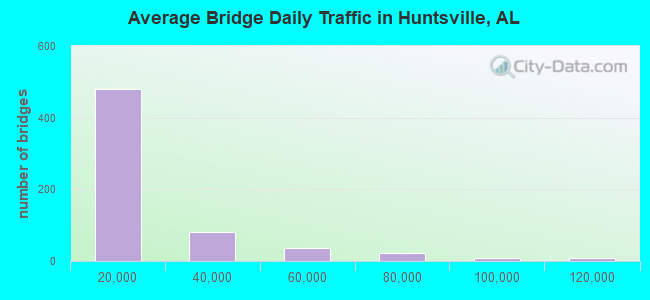
- 10,240,811Total average daily traffic
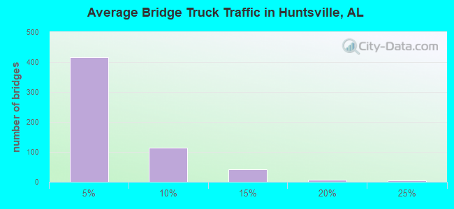
- 528,271Total average daily truck traffic
- National Bridge Inventory (NBI) Registered Bridges for Huntsville
- No street view available for this location
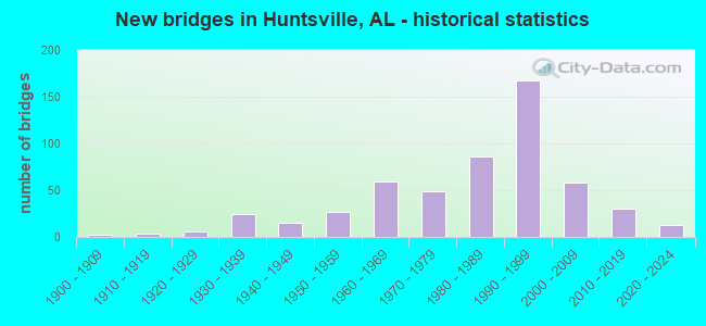
- New bridges - historical statistics
- 21900-1909
- 31910-1919
- 131920-1929
- 381930-1939
- 241940-1949
- 421950-1959
- 711960-1969
- 551970-1979
- 1011980-1989
- 1771990-1999
- 662000-2009
- 352010-2019
- 122020-2022
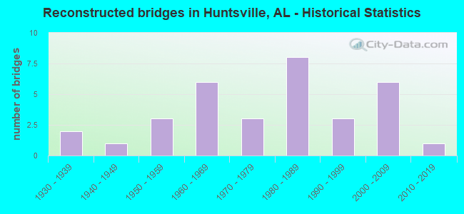
- Reconstructed bridges - Historical Statistics
- 21930-1939
- 11940-1949
- 31950-1959
- 61960-1969
- 31970-1979
- 81980-1989
- 31990-1999
- 62000-2009
- 12010-2019
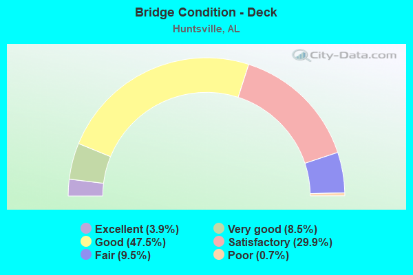
- Bridge Condition - Deck
- 3.9%Excellent
- 8.5%Very good
- 47.5%Good
- 29.9%Satisfactory
- 9.5%Fair
- 0.7%Poor
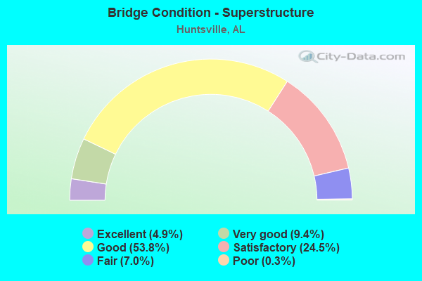
- Bridge Condition - Superstructure
- 4.9%Excellent
- 9.4%Very good
- 53.8%Good
- 24.5%Satisfactory
- 7.0%Fair
- 0.3%Poor
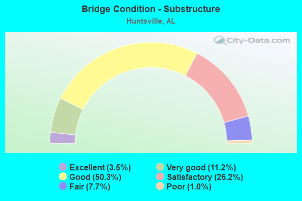
- Bridge Condition - Substructure
- 3.5%Excellent
- 11.2%Very good
- 50.3%Good
- 26.2%Satisfactory
- 7.7%Fair
- 1.0%Poor
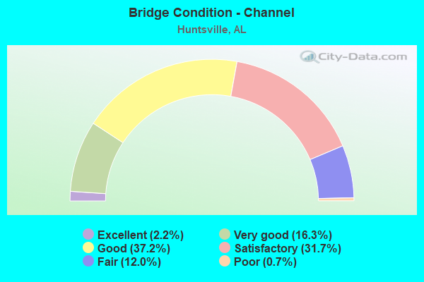
- Bridge Condition - Channel
- 2.2%Excellent
- 16.3%Very good
- 37.2%Good
- 31.7%Satisfactory
- 12.0%Fair
- 0.7%Poor
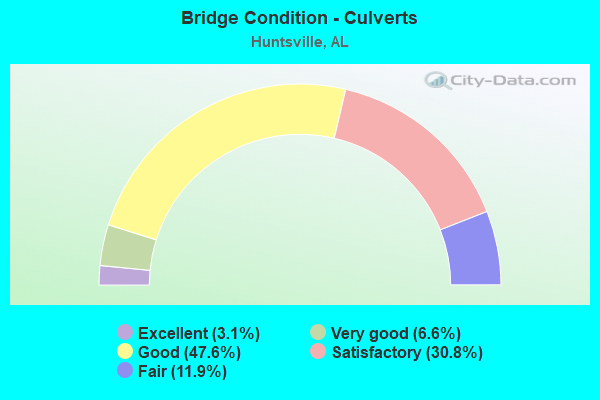
- Bridge Condition - Culverts
- 3.1%Excellent
- 6.6%Very good
- 47.6%Good
- 30.8%Satisfactory
- 11.9%Fair
Find on map >> Show street view
Structure Number: 7725, Location: 803 SHERWOOD DR (Lat: 34.665000, Lng: -86.555000), Route carried "on" structure: City street , Year Built: 1962, Year Reconstructed: 2003, Status: Open, Structure Length: 3.17m (10.40ft), Average Daily Traffic: 2,725 (year 2017), Truck Traffic: 1%, Average Future Daily Traffic: 3,815 (year 2037), Design Load: H 15, Features Intersected: ALDRIDGE CREEK, Facility Carried by Structure: SHERWOOD DR
Minimum Vertical Clearance: 30+ m (98+ ft), Kilometerpoint: 0.010, Lanes on structure: 2, Owner: City or Municipal Highway Agency, Approaching Roadway Width: 9.1m (29.9ft), Material/Design: Concrete, Design/Construction: Tee Beam, Number Of Spans In Main Unit: 2, Number Of Approach Spans: 2, Length of Maximum Span: 7.9m (25.9ft), Curb or Sidewalk Widths: Left: 1.4m (4.6ft), Right: 1.4m (4.6ft), Curb-To-Curb Width: 9.3m (30.5ft), Out-to-Out Width: 9.6m (31.5ft)
Condition: Deck: Good, Superstructure: Good, Substructure: Good, Channel: Good, Operating Rating: 32.7 metric tons, Method Used To Determine Operating Rating: Field evaluation and documented engineering judgment, Inventory Rating: 23.6 metric tons, Method Used To Determine Inventory Rating: Field evaluation and documented engineering judgment, Structural Evaluation: Equal to present minimum criteria, Deck Geometry: Meets minimum limits, Waterway Adequacy: Better than present minimum criteria, Approach Roadway Alignment: Better than present minimum criteria, Length Of Structure Improvement: 4.03m (13.22ft), Designated Inspection Frequency: Every 24 months, Inspection Date: May 2021, Bridge Improvement Cost: $857,000, Roadway Improvement Cost: $86,000, Total Project Cost: $943,000 ( Estimate for 2022), Deck Structure Type: Concrete Cast-file-Place
Find on map >> Show street view
Structure Number: 7734, Location: 0.1 MI W JCT US431 *US231 (Lat: 34.720000, Lng: -86.595000), Route carried "on" structure: State highway 53, Year Built: 1962, Status: Open, Structure Length: 4.15m (13.62ft), Average Daily Traffic: 13,915 (year 2019), Truck Traffic: 4%, Average Future Daily Traffic: 19,481 (year 2039), Design Load: HS 20, Features Intersected: PINHOOK CREEK
Minimum Vertical Clearance: 30+ m (98+ ft), Kilometerpoint: 509.996, Lanes on structure: 3, Base Highway Network: Yes, Owner: State Highway Agency, Approaching Roadway Width: 14.6m (47.9ft), Skew: 13 degrees, Material/Design: Concrete, Design/Construction: Tee Beam, Number Of Spans In Main Unit: 4, Length of Maximum Span: 10.4m (34.1ft), Curb or Sidewalk Widths: Left: 1.5m (4.9ft), Right: 0.5m (1.6ft), Curb-To-Curb Width: 11.6m (38.1ft), Out-to-Out Width: 14.2m (46.6ft)
Condition: Deck: Satisfactory, Superstructure: Satisfactory, Substructure: Satisfactory, Channel: Good, Operating Rating: 49.7 metric tons, Method Used To Determine Operating Rating: Load Factor (LF), Inventory Rating: 29.8 metric tons, Method Used To Determine Inventory Rating: Load Factor (LF), Structural Evaluation: Equal to present minimum criteria, Deck Geometry: High priority of replacement, Waterway Adequacy: Better than present minimum criteria, Approach Roadway Alignment: Better than present minimum criteria, Length Of Structure Improvement: 5.12m (16.80ft), Designated Inspection Frequency: Every 24 months, Inspection Date: October 2020, Bridge Improvement Cost: $1,614,000, Roadway Improvement Cost: $161,000, Total Project Cost: $1,775,000 ( Estimate for 2022), Deck Structure Type: Concrete Cast-file-Place
Find on map >> Show street view
Structure Number: 7736, Location: 0.2 MI W JCT US231 *US431 (Lat: 34.720000, Lng: -86.598333), Route carried "on" structure: State highway 53, Year Built: 1962, Status: Open, Structure Length: 3.11m (10.20ft), Average Daily Traffic: 13,915 (year 2019), Truck Traffic: 4%, Average Future Daily Traffic: 19,401 (year 2039), Design Load: HS 20, Features Intersected: BROGLAN BRANCH
Minimum Vertical Clearance: 30+ m (98+ ft), Kilometerpoint: 510.222, Lanes on structure: 3, Base Highway Network: Yes, Owner: State Highway Agency, Approaching Roadway Width: 14.6m (47.9ft), Skew: 13 degrees, Material/Design: Concrete, Design/Construction: Tee Beam, Number Of Spans In Main Unit: 3, Length of Maximum Span: 10.4m (34.1ft), Curb or Sidewalk Widths: Left: 1.5m (4.9ft), Right: 0.5m (1.6ft), Curb-To-Curb Width: 11.6m (38.1ft), Out-to-Out Width: 14.2m (46.6ft)
Condition: Deck: Satisfactory, Superstructure: Good, Substructure: Good, Channel: Good, Operating Rating: 49.7 metric tons, Method Used To Determine Operating Rating: Load Factor (LF), Inventory Rating: 29.8 metric tons, Method Used To Determine Inventory Rating: Load Factor (LF), Structural Evaluation: Better than present minimum criteria, Deck Geometry: High priority of replacement, Waterway Adequacy: Better than present minimum criteria, Approach Roadway Alignment: Better than present minimum criteria, Length Of Structure Improvement: 3.96m (12.99ft), Designated Inspection Frequency: Every 24 months, Inspection Date: October 2020, Bridge Improvement Cost: $1,249,000, Roadway Improvement Cost: $125,000, Total Project Cost: $1,374,000 ( Estimate for 2022), Deck Structure Type: Concrete Cast-file-Place
Find on map >> Show street view
Structure Number: 7737, Location: 0.2 MI W JCT US431 *US231 (Lat: 34.720000, Lng: -86.598333), Route carried "on" structure: State highway 53, Year Built: 1962, Status: Open, Structure Length: 3.11m (10.20ft), Average Daily Traffic: 13,915 (year 2019), Truck Traffic: 4%, Average Future Daily Traffic: 19,481 (year 2039), Design Load: HS 20, Features Intersected: BROGLAN BRANCH
Minimum Vertical Clearance: 30+ m (98+ ft), Kilometerpoint: 510.222, Lanes on structure: 3, Base Highway Network: Yes, Owner: State Highway Agency, Approaching Roadway Width: 14.6m (47.9ft), Skew: 13 degrees, Material/Design: Concrete, Design/Construction: Tee Beam, Number Of Spans In Main Unit: 3, Length of Maximum Span: 10.4m (34.1ft), Curb or Sidewalk Widths: Left: 0.5m (1.6ft), Right: 1.5m (4.9ft), Curb-To-Curb Width: 11.6m (38.1ft), Out-to-Out Width: 14.2m (46.6ft)
Condition: Deck: Good, Superstructure: Good, Substructure: Good, Channel: Good, Operating Rating: 49.7 metric tons, Method Used To Determine Operating Rating: Load Factor (LF), Inventory Rating: 29.8 metric tons, Method Used To Determine Inventory Rating: Load Factor (LF), Structural Evaluation: Better than present minimum criteria, Deck Geometry: High priority of replacement, Waterway Adequacy: Better than present minimum criteria, Approach Roadway Alignment: Better than present minimum criteria, Length Of Structure Improvement: 3.96m (12.99ft), Designated Inspection Frequency: Every 24 months, Inspection Date: October 2020, Bridge Improvement Cost: $1,249,000, Roadway Improvement Cost: $125,000, Total Project Cost: $1,374,000 ( Estimate for 2022), Deck Structure Type: Concrete Cast-file-Place
Find on map >> Show street view
Structure Number: 7768, Location: 1207 TONEY DRIVE (Lat: 34.698333, Lng: -86.550000), Route carried "on" structure: City street , Year Built: 1962, Status: Open, Structure Length: 1.52m (4.99ft), Average Daily Traffic: 3,310 (year 2015), Truck Traffic: 1%, Average Future Daily Traffic: 4,250 (year 2035), Design Load: H 15, Features Intersected: ALDRIDGE CREEK, Facility Carried by Structure: TONEY DRIVE
Minimum Vertical Clearance: 30+ m (98+ ft), Kilometerpoint: 0.010, Lanes on structure: 2, Owner: City or Municipal Highway Agency, Approaching Roadway Width: 9.4m (30.8ft), Skew: 3 degrees, Material/Design: Concrete, Design/Construction: Tee Beam, Number Of Spans In Main Unit: 2, Length of Maximum Span: 7.6m (24.9ft), Curb or Sidewalk Widths: Left: 1.4m (4.6ft), Right: 1.4m (4.6ft), Curb-To-Curb Width: 9.3m (30.5ft), Out-to-Out Width: 12.6m (41.3ft)
Condition: Deck: Good, Superstructure: Good, Substructure: Good, Channel: Very good, Operating Rating: 54.6 metric tons, Method Used To Determine Operating Rating: Load Factor (LF), Inventory Rating: 32.8 metric tons, Method Used To Determine Inventory Rating: Load Factor (LF), Structural Evaluation: Better than present minimum criteria, Deck Geometry: Meets minimum limits, Waterway Adequacy: Equal to present desirable criteria, Approach Roadway Alignment: Better than present minimum criteria, Length Of Structure Improvement: 2.20m (7.22ft), Designated Inspection Frequency: Every 24 months, Inspection Date: April 2020, Bridge Improvement Cost: $619,000, Roadway Improvement Cost: $62,000, Total Project Cost: $681,000 ( Estimate for 2022), Deck Structure Type: Concrete Cast-file-Place
Find on map >> Show street view
Structure Number: 7799, Location: 3208 NORMANDALE (Lat: 34.766667, Lng: -86.580000), Route carried "on" structure: City street , Year Built: 1962, Status: Open, Structure Length: 0.76m (2.49ft), Average Daily Traffic: 750 (year 2017), Truck Traffic: 1%, Average Future Daily Traffic: 1,050 (year 2037), Design Load: HS 20, Features Intersected: BRANCH, Facility Carried by Structure: NORMANDALE
Minimum Vertical Clearance: 7.56m (24.80ft), Kilometerpoint: 0.010, Lanes on structure: 2, Owner: City or Municipal Highway Agency, Approaching Roadway Width: 8.8m (28.9ft), Material/Design: Concrete, Design/Construction: Culvert, Number Of Spans In Main Unit: 2, Length of Maximum Span: 3.7m (12.1ft)
Condition: Channel: Good, Culverts: Fair, Operating Rating: 47.2 metric tons, Method Used To Determine Operating Rating: Load Factor (LF), Inventory Rating: 28.2 metric tons, Method Used To Determine Inventory Rating: Load Factor (LF), Structural Evaluation: Somewhat better than minimum adequacy, Waterway Adequacy: Equal to present minimum criteria, Approach Roadway Alignment: Somewhat better than minimum adequacy, Length Of Structure Improvement: 1.41m (4.63ft), Designated Inspection Frequency: Every 24 months, Inspection Date: August 2020, Bridge Improvement Cost: $406,000, Roadway Improvement Cost: $41,000, Total Project Cost: $447,000 ( Estimate for 2022)
Find on map >> Show street view
Structure Number: 8062, Location: SEC14 T3S R3W (Lat: 34.777856, Lng: -86.823847), Route carried "on" structure: County highway 111, Year Built: 1963, Status: Open, Structure Length: 0.62m (2.03ft), Average Daily Traffic: 575 (year 2014), Truck Traffic: 1%, Average Future Daily Traffic: 850 (year 2034), Design Load: H 15, Features Intersected: BRANCH, Facility Carried by Structure: MENEFFEE RD
Minimum Vertical Clearance: 30+ m (98+ ft), Kilometerpoint: 0.010, Lanes on structure: 2, Owner: County Highway Agency, Approaching Roadway Width: 8.5m (27.9ft), Material/Design: Concrete, Design/Construction: Culvert, Number Of Spans In Main Unit: 3, Length of Maximum Span: 1.8m (5.9ft), Curb-To-Curb Width: 9.9m (32.5ft), Out-to-Out Width: 10.4m (34.1ft)
Condition: Channel: Good, Culverts: Good, Operating Rating: 46.1 metric tons, Method Used To Determine Operating Rating: Load Factor (LF), Inventory Rating: 27.7 metric tons, Method Used To Determine Inventory Rating: Load Factor (LF), Structural Evaluation: Equal to present minimum criteria, Deck Geometry: Equal to present minimum criteria, Waterway Adequacy: Equal to present minimum criteria, Approach Roadway Alignment: Better than present minimum criteria, Length Of Structure Improvement: 1.23m (4.04ft), Designated Inspection Frequency: Every 24 months, Inspection Date: December 2020, Bridge Improvement Cost: $242,000, Roadway Improvement Cost: $24,000, Total Project Cost: $266,000 ( Estimate for 2022)
Find on map >> Show street view
Structure Number: 8088, Location: 1.5 MI E JCT CO RD 155 (Lat: 34.564969, Lng: -86.538631), Route carried "on" structure: County highway 366, Year Built: 1963, Status: Open, Structure Length: 0.76m (2.49ft), Average Daily Traffic: 250 (year 1992), Truck Traffic: 1%, Average Future Daily Traffic: 315 (year 2040), Design Load: H 15, Features Intersected: LEE HOLLOW BRANCH, Facility Carried by Structure: HEGIA BURROW RD
Minimum Vertical Clearance: 30+ m (98+ ft), Kilometerpoint: 0.010, Lanes on structure: 2, Owner: County Highway Agency, Approaching Roadway Width: 7.9m (25.9ft), Skew: 3 degrees, Material/Design: Concrete, Design/Construction: Culvert, Number Of Spans In Main Unit: 2, Length of Maximum Span: 4.0m (13.1ft), Curb-To-Curb Width: 11.0m (36.1ft), Out-to-Out Width: 11.4m (37.4ft)
Condition: Channel: Satisfactory, Culverts: Fair, Operating Rating: 41.6 metric tons, Method Used To Determine Operating Rating: Load Factor (LF), Inventory Rating: 24.9 metric tons, Method Used To Determine Inventory Rating: Load Factor (LF), Structural Evaluation: Somewhat better than minimum adequacy, Deck Geometry: Equal to present desirable criteria, Waterway Adequacy: Equal to present minimum criteria, Approach Roadway Alignment: Somewhat better than minimum adequacy, Length Of Structure Improvement: 1.41m (4.63ft), Designated Inspection Frequency: Every 24 months, Inspection Date: March 2020, Bridge Improvement Cost: $390,000, Roadway Improvement Cost: $39,000, Total Project Cost: $429,000 ( Estimate for 2022)
Find on map >> Show street view
Structure Number: 8089, Location: 0.6 MI E JCT CO RD 155 (Lat: 34.564953, Lng: -86.524939), Route carried "on" structure: County highway 366, Year Built: 1963, Status: Open, Structure Length: 1.19m (3.90ft), Average Daily Traffic: 250 (year 1992), Truck Traffic: 1%, Average Future Daily Traffic: 285 (year 2040), Design Load: H 15, Features Intersected: CAMPBELL COVE BRANCH, Facility Carried by Structure: HEGIA BURROW RD
Minimum Vertical Clearance: 30+ m (98+ ft), Kilometerpoint: 0.010, Lanes on structure: 2, Owner: County Highway Agency, Approaching Roadway Width: 8.5m (27.9ft), Material/Design: Concrete, Design/Construction: Culvert, Number Of Spans In Main Unit: 3, Length of Maximum Span: 4.0m (13.1ft), Curb-To-Curb Width: 17.8m (58.4ft), Out-to-Out Width: 18.3m (60.0ft)
Condition: Channel: Satisfactory, Culverts: Satisfactory, Operating Rating: 88.9 metric tons, Method Used To Determine Operating Rating: Load Factor (LF), Inventory Rating: 88.9 metric tons, Method Used To Determine Inventory Rating: Load Factor (LF), Structural Evaluation: Equal to present minimum criteria, Deck Geometry: Superior to present desirable criteria, Waterway Adequacy: Equal to present minimum criteria, Approach Roadway Alignment: Equal to present minimum criteria, Length Of Structure Improvement: 1.86m (6.10ft), Designated Inspection Frequency: Every 24 months, Inspection Date: March 2020, Bridge Improvement Cost: $645,000, Roadway Improvement Cost: $65,000, Total Project Cost: $710,000 ( Estimate for 2022)
Find on map >> Show street view
Structure Number: 8114, Location: H'VILLE SP BR ATBOBWALACE (Lat: 34.700183, Lng: -86.583511), Route carried "on" structure: City street , Year Built: 1955, Year Reconstructed: 1964, Status: Open, Structure Length: 3.83m (12.57ft), Average Daily Traffic: 20,000 (year 2015), Truck Traffic: 1%, Average Future Daily Traffic: 28,000 (year 2035), Design Load: H 15, Features Intersected: HUNTSVILLE SPG BRANCH, Facility Carried by Structure: BOB WALLACE
Minimum Vertical Clearance: 30+ m (98+ ft), Kilometerpoint: 0.010, Lanes on structure: 5, Owner: City or Municipal Highway Agency, Approaching Roadway Width: 15.8m (51.8ft), Skew: 20 degrees, Material/Design: Concrete, Design/Construction: Tee Beam, Number Of Spans In Main Unit: 4, Length of Maximum Span: 9.5m (31.2ft), Curb or Sidewalk Widths: Left: 1.2m (3.9ft), Right: 1.2m (3.9ft), Curb-To-Curb Width: 15.8m (51.8ft), Out-to-Out Width: 17.4m (57.1ft)
Condition: Deck: Good, Superstructure: Good, Substructure: Good, Channel: Good, Operating Rating: 43.5 metric tons, Method Used To Determine Operating Rating: Load Factor (LF), Inventory Rating: 30.4 metric tons, Method Used To Determine Inventory Rating: Load Factor (LF), Structural Evaluation: Better than present minimum criteria, Deck Geometry: High priority of replacement, Waterway Adequacy: Better than present minimum criteria, Approach Roadway Alignment: Equal to present desirable criteria, Length Of Structure Improvement: 4.76m (15.62ft), Designated Inspection Frequency: Every 24 months, Inspection Date: November 2020, Bridge Improvement Cost: $1,861,000, Roadway Improvement Cost: $186,000, Total Project Cost: $2,047,000 ( Estimate for 2022), Deck Structure Type: Concrete Cast-file-Place
Find on map >> Show street view
Structure Number: 8696, Location: 0.9 MI N US 72 HWY (Lat: 34.759589, Lng: -86.785917), Route carried "on" structure: County highway 11, Year Built: 1965, Status: Open, Structure Length: 1.01m (3.31ft), Average Daily Traffic: 6,458 (year 2003), Truck Traffic: 1%, Average Future Daily Traffic: 7,713 (year 2035), Design Load: H 15, Features Intersected: KNOX CREEK, Facility Carried by Structure: OLD R R BED RD
Minimum Vertical Clearance: 30+ m (98+ ft), Kilometerpoint: 0.010, Lanes on structure: 2, Owner: County Highway Agency, Approaching Roadway Width: 8.5m (27.9ft), Material/Design: Concrete, Design/Construction: Culvert, Number Of Spans In Main Unit: 3, Length of Maximum Span: 3.0m (9.8ft), Curb-To-Curb Width: 13.9m (45.6ft), Out-to-Out Width: 14.3m (46.9ft)
Condition: Channel: Fair, Culverts: Satisfactory, Operating Rating: 88.9 metric tons, Method Used To Determine Operating Rating: Load Factor (LF), Inventory Rating: 71.8 metric tons, Method Used To Determine Inventory Rating: Load Factor (LF), Structural Evaluation: Equal to present minimum criteria, Deck Geometry: Superior to present desirable criteria, Waterway Adequacy: Equal to present minimum criteria, Approach Roadway Alignment: Equal to present minimum criteria, Length Of Structure Improvement: 1.68m (5.51ft), Designated Inspection Frequency: Every 24 months, Inspection Date: November 2020, Bridge Improvement Cost: $456,000, Roadway Improvement Cost: $46,000, Total Project Cost: $502,000 ( Estimate for 2022)
Find on map >> Show street view
Structure Number: 8697, Location: 3.6 MI N US 72 HWY (Lat: 34.799258, Lng: -86.783458), Route carried "on" structure: County highway 11, Year Built: 1965, Status: Open, Structure Length: 1.13m (3.71ft), Average Daily Traffic: 3,798 (year 2002), Truck Traffic: 1%, Average Future Daily Traffic: 4,560 (year 2040), Design Load: H 15, Features Intersected: DAVIS BRANCH, Facility Carried by Structure: OLD RR BED RD
Minimum Vertical Clearance: 30+ m (98+ ft), Kilometerpoint: 0.010, Lanes on structure: 2, Owner: County Highway Agency, Approaching Roadway Width: 8.5m (27.9ft), Skew: 4 degrees, Material/Design: Concrete, Design/Construction: Culvert, Number Of Spans In Main Unit: 3, Length of Maximum Span: 2.4m (7.9ft), Curb-To-Curb Width: 10.7m (35.1ft), Out-to-Out Width: 11.2m (36.7ft)
Condition: Channel: Fair, Culverts: Fair, Operating Rating: 45.5 metric tons, Method Used To Determine Operating Rating: Load Factor (LF), Inventory Rating: 27.3 metric tons, Method Used To Determine Inventory Rating: Load Factor (LF), Structural Evaluation: Somewhat better than minimum adequacy, Deck Geometry: Somewhat better than minimum adequacy, Waterway Adequacy: Somewhat better than minimum adequacy, Approach Roadway Alignment: Equal to present minimum criteria, Length Of Structure Improvement: 1.81m (5.94ft), Designated Inspection Frequency: Every 24 months, Inspection Date: November 2020, Bridge Improvement Cost: $542,000, Roadway Improvement Cost: $54,000, Total Project Cost: $596,000 ( Estimate for 2022)
Find on map >> Show street view
Structure Number: 8698, Location: 2.4 MI N JCT US HWY72 (Lat: 34.787856, Lng: -86.785578), Route carried "on" structure: County highway 11, Year Built: 1965, Status: Open, Structure Length: 0.67m (2.20ft), Average Daily Traffic: 3,798 (year 2002), Truck Traffic: 1%, Average Future Daily Traffic: 4,557 (year 2035), Design Load: H 15, Features Intersected: JENKINS CREEK, Facility Carried by Structure: OLD R R BED RD
Minimum Vertical Clearance: 30+ m (98+ ft), Kilometerpoint: 0.010, Lanes on structure: 2, Owner: County Highway Agency, Approaching Roadway Width: 8.5m (27.9ft), Skew: 1 degrees, Material/Design: Concrete, Design/Construction: Culvert, Number Of Spans In Main Unit: 2, Length of Maximum Span: 3.0m (9.8ft), Curb-To-Curb Width: 12.4m (40.7ft), Out-to-Out Width: 13.0m (42.7ft)
Condition: Channel: Satisfactory, Culverts: Good, Operating Rating: 75.8 metric tons, Method Used To Determine Operating Rating: Load Factor (LF), Inventory Rating: 45.4 metric tons, Method Used To Determine Inventory Rating: Load Factor (LF), Structural Evaluation: Better than present minimum criteria, Deck Geometry: Equal to present minimum criteria, Waterway Adequacy: Equal to present minimum criteria, Approach Roadway Alignment: Equal to present minimum criteria, Length Of Structure Improvement: 1.30m (4.27ft), Designated Inspection Frequency: Every 24 months, Inspection Date: September 2020, Bridge Improvement Cost: $330,000, Roadway Improvement Cost: $33,000, Total Project Cost: $363,000 ( Estimate for 2022)
Find on map >> Show street view
Structure Number: 8735, Location: 1.8 MI W JCT SR255 * SR20 (Lat: 34.696667, Lng: -86.701667), Route carried "on" structure: City street 20, Year Built: 1965, Status: Open, Structure Length: 9.33m (30.61ft), Average Daily Traffic: 34,900 (year 2017), Truck Traffic: 8%, Average Future Daily Traffic: 48,860 (year 2037), Design Load: HS 20, Features Intersected: INDIAN CREEK, Facility Carried by Structure: Madison Blvd
Minimum Vertical Clearance: 30+ m (98+ ft), Kilometerpoint: 0.322, Lanes on structure: 2, Owner: City or Municipal Highway Agency, Approaching Roadway Width: 8.5m (27.9ft), Skew: 10 degrees, Material/Design: Concrete, Design/Construction: Tee Beam, Number Of Spans In Main Unit: 9, Length of Maximum Span: 10.4m (34.1ft), Curb or Sidewalk Widths: Left: 0.5m (1.6ft), Right: 0.5m (1.6ft), Curb-To-Curb Width: 8.5m (27.9ft), Out-to-Out Width: 10.1m (33.1ft)
Condition: Deck: Fair, Superstructure: Satisfactory, Substructure: Satisfactory, Channel: Fair, Operating Rating: 67.0 metric tons, Method Used To Determine Operating Rating: Allowable Stress (AS), Inventory Rating: 43.6 metric tons, Method Used To Determine Inventory Rating: Allowable Stress (AS), Structural Evaluation: Equal to present minimum criteria, Deck Geometry: High priority of corrective action, Waterway Adequacy: Better than present minimum criteria, Approach Roadway Alignment: Better than present minimum criteria, Length Of Structure Improvement: 10.29m (33.76ft), Designated Inspection Frequency: Every 24 months, Inspection Date: April 2021, Bridge Improvement Cost: $2,328,000, Roadway Improvement Cost: $233,000, Total Project Cost: $2,561,000 ( Estimate for 2022), Deck Structure Type: Concrete Cast-file-Place
Find on map >> Show street view
Structure Number: 8744, Location: ALDRIDGE CREEK AT WEA. RD (Lat: 34.646667, Lng: -86.541667), Route carried "on" structure: City street , Year Built: 1965, Status: Open, Structure Length: 3.12m (10.24ft), Average Daily Traffic: 13,600 (year 2018), Truck Traffic: 1%, Average Future Daily Traffic: 19,040 (year 2038), Design Load: H 15, Features Intersected: ALDRIDGE CREEK, Facility Carried by Structure: WEATHERLY RD
Minimum Vertical Clearance: 30+ m (98+ ft), Kilometerpoint: 0.010, Lanes on structure: 4, Owner: City or Municipal Highway Agency, Approaching Roadway Width: 14.9m (48.9ft), Skew: 23 degrees, Material/Design: Concrete, Design/Construction: Tee Beam, Number Of Spans In Main Unit: 3, Length of Maximum Span: 10.4m (34.1ft), Curb or Sidewalk Widths: Left: 0.4m (1.3ft), Right: 1.4m (4.6ft), Curb-To-Curb Width: 14.8m (48.6ft), Out-to-Out Width: 17.2m (56.4ft)
Condition: Deck: Satisfactory, Superstructure: Good, Substructure: Good, Channel: Satisfactory, Operating Rating: 32.7 metric tons, Method Used To Determine Operating Rating: Field evaluation and documented engineering judgment, Inventory Rating: 23.6 metric tons, Method Used To Determine Inventory Rating: Field evaluation and documented engineering judgment, Structural Evaluation: Somewhat better than minimum adequacy, Deck Geometry: High priority of replacement, Waterway Adequacy: Equal to present desirable criteria, Approach Roadway Alignment: Equal to present desirable criteria, Length Of Structure Improvement: 3.97m (13.02ft), Designated Inspection Frequency: Every 24 months, Inspection Date: July 2020, Bridge Improvement Cost: $1,525,000, Roadway Improvement Cost: $153,000, Total Project Cost: $1,678,000 ( Estimate for 2022), Deck Structure Type: Concrete Cast-file-Place
Find on map >> Show street view
Structure Number: 8793, Location: 1910 BRANDONTOWN RD (Lat: 34.748333, Lng: -86.628333), Route carried "on" structure: City street , Year Built: 1965, Status: Open, Structure Length: 1.31m (4.30ft), Average Daily Traffic: 750 (year 2017), Truck Traffic: 1%, Average Future Daily Traffic: 1,050 (year 2037), Design Load: H 15, Features Intersected: DRY CREEK, Facility Carried by Structure: BRANDONTOWN RD
Minimum Vertical Clearance: 30+ m (98+ ft), Kilometerpoint: 0.010, Lanes on structure: 3, Owner: City or Municipal Highway Agency, Approaching Roadway Width: 9.1m (29.9ft), Skew: 4 degrees, Material/Design: Concrete, Design/Construction: Culvert, Number Of Spans In Main Unit: 3, Length of Maximum Span: 3.7m (12.1ft), Curb or Sidewalk Widths: Left: 1.5m (4.9ft), Right: 0.0m, Curb-To-Curb Width: 9.1m (29.9ft), Out-to-Out Width: 18.3m (60.0ft)
Condition: Channel: Good, Culverts: Satisfactory, Operating Rating: 47.2 metric tons, Method Used To Determine Operating Rating: Load Factor (LF), Inventory Rating: 28.3 metric tons, Method Used To Determine Inventory Rating: Load Factor (LF), Structural Evaluation: Equal to present minimum criteria, Deck Geometry: High priority of replacement, Waterway Adequacy: Better than present minimum criteria, Approach Roadway Alignment: Better than present minimum criteria, Length Of Structure Improvement: 1.98m (6.50ft), Designated Inspection Frequency: Every 24 months, Inspection Date: July 2020, Bridge Improvement Cost: $688,000, Roadway Improvement Cost: $69,000, Total Project Cost: $757,000 ( Estimate for 2022)
Find on map >> Show street view
Structure Number: 8798, Location: 1 MI S JCT US431 * US231 (Lat: 34.705142, Lng: -86.588269), Route carried "on" structure: US 231, Year Built: 1965, Status: Open, Structure Length: 0.73m (2.40ft), Average Daily Traffic: 102,157 (year 2019), Truck Traffic: 3%, Average Future Daily Traffic: 143,020 (year 2039), Design Load: HS 20, Features Intersected: BRANCH * DRAKE AVE
Minimum Vertical Clearance: 30+ m (98+ ft), Kilometerpoint: 508.269, Lanes on structure: 10, Base Highway Network: Yes, Owner: State Highway Agency, Approaching Roadway Width: 36.6m (120.1ft), Skew: 23 degrees, Material/Design: Concrete, Design/Construction: Culvert, Number Of Spans In Main Unit: 3, Length of Maximum Span: 2.4m (7.9ft)
Condition: Channel: Very good, Culverts: Satisfactory, Operating Rating: 51.6 metric tons, Method Used To Determine Operating Rating: Load Factor (LF), Inventory Rating: 30.9 metric tons, Method Used To Determine Inventory Rating: Load Factor (LF), Structural Evaluation: Equal to present minimum criteria, Waterway Adequacy: Equal to present desirable criteria, Approach Roadway Alignment: Equal to present desirable criteria, Length Of Structure Improvement: 1.38m (4.53ft), Designated Inspection Frequency: Every 24 months, Inspection Date: October 2020, Bridge Improvement Cost: $4,960,000, Roadway Improvement Cost: $496,000, Total Project Cost: $5,456,000 ( Estimate for 2022)
Find on map >> Show street view
Structure Number: 8809, Location: MORGAN-MADISON CO LINE (Lat: 34.575000, Lng: -86.566667), Route carried "on" structure: US 231, Year Built: 1965, Status: Open, Structure Length: 62.39m (204.69ft), Average Daily Traffic: 10,175 (year 2021), Truck Traffic: 3%, Average Future Daily Traffic: 13,226 (year 2033), Design Load: HS 20, Features Intersected: TENNESSEE RIVER, Facility Carried by Structure: SR 53
Minimum Vertical Clearance: 4.95m (16.24ft), Kilometerpoint: 493.137, Lanes on structure: 2, Base Highway Network: Yes, Owner: State Highway Agency, Approaching Roadway Width: 12.8m (42.0ft), Skew: 10 degrees, Navigation Control: Yes ( Vertical Clearance: 20.1m (65.9ft), Horizontal Clearance: 106.7m (350.1ft)), Material/Design: Steel, Design/Construction: Truss - Thru, Number Of Spans In Main Unit: 3, Number Of Approach Spans: 9, Length of Maximum Span: 109.7m (359.9ft), Curb or Sidewalk Widths: Left: 0.5m (1.6ft), Right: 0.5m (1.6ft), Curb-To-Curb Width: 8.5m (27.9ft), Out-to-Out Width: 10.1m (33.1ft)
Condition: Deck: Fair, Superstructure: Satisfactory, Substructure: Fair, Channel: Good, Operating Rating: 48.6 metric tons, Method Used To Determine Operating Rating: Load Factor (LF), Inventory Rating: 29.1 metric tons, Method Used To Determine Inventory Rating: Load Factor (LF), Structural Evaluation: Somewhat better than minimum adequacy, Deck Geometry: High priority of corrective action, Waterway Adequacy: Equal to present desirable criteria, Approach Roadway Alignment: Equal to present minimum criteria, Length Of Structure Improvement: 62.39m (204.69ft), Designated Inspection Frequency: Every 24 months, Critical Feature Inspection Frequency: Every 24 months, Underwater Inspection Frequency: Every 24 months, Inspection Date: October 2021, Critical Feature Inspection Date: October 2021, Underwater Inspection Date: July 2021, Bridge Improvement Cost: $14,117,000, Roadway Improvement Cost: $1,412,000, Total Project Cost: $15,529,000 ( Estimate for 2022), Deck Structure Type: Concrete Cast-file-Place
Find on map >> Show street view
Structure Number: 8855, Location: OLIVE DR * BLOSSOMWOODSCH (Lat: 34.706667, Lng: -86.568333), Route carried "on" structure: City street , Year Built: 1965, Status: Open, Structure Length: 1.28m (4.20ft), Average Daily Traffic: 900 (year 2017), Truck Traffic: 1%, Average Future Daily Traffic: 1,260 (year 2037), Design Load: H 10, Features Intersected: FAGAN CREEK, Facility Carried by Structure: OLIVE DR SE
Minimum Vertical Clearance: 30+ m (98+ ft), Kilometerpoint: 0.010, Lanes on structure: 2, Owner: City or Municipal Highway Agency, Approaching Roadway Width: 9.4m (30.8ft), Material/Design: Concrete, Design/Construction: Culvert, Number Of Spans In Main Unit: 3, Length of Maximum Span: 4.6m (15.1ft), Curb or Sidewalk Widths: Left: 2.0m (6.6ft), Right: 1.8m (5.9ft), Curb-To-Curb Width: 9.3m (30.5ft), Out-to-Out Width: 13.1m (43.0ft)
Condition: Channel: Very good, Culverts: Satisfactory, Operating Rating: 32.7 metric tons, Method Used To Determine Operating Rating: Field evaluation and documented engineering judgment, Inventory Rating: 23.6 metric tons, Method Used To Determine Inventory Rating: Field evaluation and documented engineering judgment, Structural Evaluation: Equal to present minimum criteria, Deck Geometry: Equal to present minimum criteria, Waterway Adequacy: Better than present minimum criteria, Approach Roadway Alignment: Better than present minimum criteria, Length Of Structure Improvement: 1.95m (6.40ft), Designated Inspection Frequency: Every 24 months, Inspection Date: August 2020, Bridge Improvement Cost: $417,000, Roadway Improvement Cost: $42,000, Total Project Cost: $459,000 ( Estimate for 2022)
Find on map >> Show street view
Structure Number: 8894, Location: 5314 GRIZZARD RD (Lat: 34.763333, Lng: -86.643333), Route carried "on" structure: City street , Year Built: 1965, Status: Open, Structure Length: 1.28m (4.20ft), Average Daily Traffic: 2,475 (year 2015), Truck Traffic: 1%, Average Future Daily Traffic: 3,465 (year 2035), Design Load: H 15, Features Intersected: DRY CREEK, Facility Carried by Structure: GRIZZARD RD
Minimum Vertical Clearance: 30+ m (98+ ft), Kilometerpoint: 0.010, Lanes on structure: 3, Owner: City or Municipal Highway Agency, Approaching Roadway Width: 12.2m (40.0ft), Material/Design: Concrete, Design/Construction: Culvert, Number Of Spans In Main Unit: 4, Length of Maximum Span: 3.0m (9.8ft), Curb or Sidewalk Widths: Left: 0.0m, Right: 1.2m (3.9ft)
Condition: Channel: Satisfactory, Culverts: Satisfactory, Operating Rating: 64.2 metric tons, Method Used To Determine Operating Rating: Load Factor (LF), Inventory Rating: 38.6 metric tons, Method Used To Determine Inventory Rating: Load Factor (LF), Structural Evaluation: Equal to present minimum criteria, Waterway Adequacy: Better than present minimum criteria, Approach Roadway Alignment: Better than present minimum criteria, Length Of Structure Improvement: 1.95m (6.40ft), Designated Inspection Frequency: Every 24 months, Inspection Date: March 2021, Bridge Improvement Cost: $790,000, Roadway Improvement Cost: $79,000, Total Project Cost: $869,000 ( Estimate for 2022)
Find on map >> Show street view
Structure Number: 8895, Location: 5314 MASTIN LAKE RD (Lat: 34.766747, Lng: -86.633511), Route carried "on" structure: City street , Year Built: 1965, Status: Open, Structure Length: 1.52m (4.99ft), Average Daily Traffic: 12,000 (year 2016), Truck Traffic: 2%, Average Future Daily Traffic: 16,800 (year 2036), Design Load: H 15, Features Intersected: DRY CREEK, Facility Carried by Structure: MASTIN LAKE RD
Minimum Vertical Clearance: 30+ m (98+ ft), Kilometerpoint: 0.010, Lanes on structure: 5, Owner: City or Municipal Highway Agency, Approaching Roadway Width: 15.8m (51.8ft), Material/Design: Concrete, Design/Construction: Culvert, Number Of Spans In Main Unit: 4, Length of Maximum Span: 3.7m (12.1ft), Curb or Sidewalk Widths: Left: 0.0m, Right: 1.8m (5.9ft), Curb-To-Curb Width: 15.8m (51.8ft), Out-to-Out Width: 19.8m (65.0ft)
Condition: Channel: Satisfactory, Culverts: Satisfactory, Operating Rating: 57.2 metric tons, Method Used To Determine Operating Rating: Load Factor (LF), Inventory Rating: 34.3 metric tons, Method Used To Determine Inventory Rating: Load Factor (LF), Structural Evaluation: Equal to present minimum criteria, Deck Geometry: High priority of replacement, Waterway Adequacy: Better than present minimum criteria, Approach Roadway Alignment: Better than present minimum criteria, Length Of Structure Improvement: 2.20m (7.22ft), Designated Inspection Frequency: Every 24 months, Inspection Date: March 2021, Bridge Improvement Cost: $826,000, Roadway Improvement Cost: $83,000, Total Project Cost: $909,000 ( Estimate for 2022)
Find on map >> Show street view
Structure Number: 8906, Location: 1020 MAYSVILLE RD (Lat: 34.746667, Lng: -86.565000), Route carried "on" structure: City street , Year Built: 1965, Status: Open, Structure Length: 0.85m (2.79ft), Average Daily Traffic: 2,500 (year 2017), Truck Traffic: 1%, Average Future Daily Traffic: 3,500 (year 2037), Design Load: H 15, Features Intersected: DALLAS CREEK, Facility Carried by Structure: MAYSVILLE RD
Minimum Vertical Clearance: 7.56m (24.80ft), Kilometerpoint: 0.010, Lanes on structure: 4, Owner: City or Municipal Highway Agency, Approaching Roadway Width: 15.5m (50.9ft), Skew: 3 degrees, Material/Design: Concrete, Design/Construction: Culvert, Number Of Spans In Main Unit: 2, Length of Maximum Span: 4.3m (14.1ft), Curb or Sidewalk Widths: Left: 1.2m (3.9ft), Right: 0.0m, Curb-To-Curb Width: 15.6m (51.2ft), Out-to-Out Width: 20.5m (67.3ft)
Condition: Channel: Very good, Culverts: Fair, Operating Rating: 37.0 metric tons, Method Used To Determine Operating Rating: Load Factor (LF), Inventory Rating: 22.1 metric tons, Method Used To Determine Inventory Rating: Load Factor (LF), Structural Evaluation: Somewhat better than minimum adequacy, Deck Geometry: Meets minimum limits, Waterway Adequacy: Better than present minimum criteria, Approach Roadway Alignment: Equal to present minimum criteria, Length Of Structure Improvement: 1.51m (4.95ft), Designated Inspection Frequency: Every 24 months, Inspection Date: May 2020, Bridge Improvement Cost: $664,000, Roadway Improvement Cost: $66,000, Total Project Cost: $730,000 ( Estimate for 2022)
Find on map >> Show street view
Structure Number: 907, Location: 2.1 MI W REDSTONE (Lat: 34.651189, Lng: -86.752778), Route carried "on" structure: City street , Year Built: 1966, Status: Open, Structure Length: 7.28m (23.88ft), Average Daily Traffic: 5,500 (year 2019), Truck Traffic: 2%, Average Future Daily Traffic: 7,700 (year 2039), Design Load: HS 20, Features Intersected: BRADFORD CREEK, Facility Carried by Structure: JAMES RECORD RD
Minimum Vertical Clearance: 30+ m (98+ ft), Kilometerpoint: 0.000, Lanes on structure: 2, Owner: City or Municipal Highway Agency, Approaching Roadway Width: 7.0m (23.0ft), Skew: 4 degrees, Material/Design: Concrete, Design/Construction: Tee Beam, Number Of Spans In Main Unit: 7, Length of Maximum Span: 10.4m (34.1ft), Curb-To-Curb Width: 8.7m (28.5ft), Out-to-Out Width: 10.1m (33.1ft)
Condition: Deck: Satisfactory, Superstructure: Satisfactory, Substructure: Good, Channel: Satisfactory, Operating Rating: 72.6 metric tons, Method Used To Determine Operating Rating: Load Factor (LF), Inventory Rating: 43.5 metric tons, Method Used To Determine Inventory Rating: Load Factor (LF), Structural Evaluation: Equal to present minimum criteria, Deck Geometry: Meets minimum limits, Waterway Adequacy: Better than present minimum criteria, Approach Roadway Alignment: Equal to present minimum criteria, Length Of Structure Improvement: 8.31m (27.26ft), Designated Inspection Frequency: Every 24 months, Inspection Date: December 2021, Bridge Improvement Cost: $1,881,000, Roadway Improvement Cost: $188,000, Total Project Cost: $2,069,000 ( Estimate for 2022), Deck Structure Type: Concrete Cast-file-Place
Find on map >> Show street view
Structure Number: 9218, Location: 0.25 MI E CO RD 1240 (Lat: 34.704644, Lng: -86.512333), Route carried "on" structure: County highway 332, Year Built: 1940, Year Reconstructed: 1967, Status: Open, Structure Length: 1.77m (5.81ft), Average Daily Traffic: 850 (year 1990), Truck Traffic: 1%, Average Future Daily Traffic: 1,210 (year 2040), Design Load: H 15, Features Intersected: BIG COVE CREEK, Facility Carried by Structure: DUG HILL RD
Minimum Vertical Clearance: 30+ m (98+ ft), Kilometerpoint: 0.010, Lanes on structure: 2, Owner: County Highway Agency, Approaching Roadway Width: 7.3m (24.0ft), Material/Design: Concrete, Design/Construction: Slab, Number Of Spans In Main Unit: 4, Length of Maximum Span: 4.6m (15.1ft), Curb-To-Curb Width: 5.8m (19.0ft), Out-to-Out Width: 6.2m (20.3ft)
Condition: Deck: Fair, Superstructure: Satisfactory, Substructure: Fair, Channel: Satisfactory, Operating Rating: 43.5 metric tons, Method Used To Determine Operating Rating: Field evaluation and documented engineering judgment, Inventory Rating: 32.7 metric tons, Method Used To Determine Inventory Rating: Field evaluation and documented engineering judgment, Structural Evaluation: Somewhat better than minimum adequacy, Deck Geometry: High priority of replacement, Waterway Adequacy: Equal to present minimum criteria, Approach Roadway Alignment: Somewhat better than minimum adequacy, Length Of Structure Improvement: 2.48m (8.14ft), Designated Inspection Frequency: Every 24 months, Inspection Date: September 2020, Bridge Improvement Cost: $340,000, Roadway Improvement Cost: $34,000, Total Project Cost: $374,000 ( Estimate for 2022), Deck Structure Type: Concrete Cast-file-Place, Wearing Surface/Protective System: Wearing Surface: Bituminous
Find on map >> Show street view
Structure Number: 9357, Location: 0.1 MI S CO RD 043 (Lat: 34.814519, Lng: -86.696903), Route carried "on" structure: County highway 31, Year Built: 1967, Status: Posted for load, Structure Length: 0.91m (2.99ft), Average Daily Traffic: 120 (year 1992), Truck Traffic: 1%, Average Future Daily Traffic: 160 (year 2040), Design Load: H 10, Features Intersected: HAM CREEK, Facility Carried by Structure: INDIAN CREEK RD
Minimum Vertical Clearance: 30+ m (98+ ft), Kilometerpoint: 0.010, Lanes on structure: 2, Owner: County Highway Agency, Approaching Roadway Width: 7.3m (24.0ft), Material/Design: Concrete, Design/Construction: Stringer/Multi-beam, Number Of Spans In Main Unit: 1, Length of Maximum Span: 9.1m (29.9ft), Curb-To-Curb Width: 7.5m (24.6ft), Out-to-Out Width: 7.9m (25.9ft)
Condition: Deck: Fair, Superstructure: Fair, Substructure: Fair, Channel: Fair, Operating Rating: 15.1 metric tons, Method Used To Determine Operating Rating: Allowable Stress (AS), Inventory Rating: 8.1 metric tons, Method Used To Determine Inventory Rating: Allowable Stress (AS), Structural Evaluation: High priority of replacement, Deck Geometry: Somewhat better than minimum adequacy, Waterway Adequacy: Meets minimum limits, Approach Roadway Alignment: Somewhat better than minimum adequacy, Bridge Posting: Required (Relationship of Operating Rating to Maximum Legal Load: > 39.9% below), Length Of Structure Improvement: 1.58m (5.18ft), Designated Inspection Frequency: Every 24 months, Other Special Inspection Frequency: Every 12 months, Inspection Date: December 2020, Other Special Inspection Date: December 2021, Bridge Improvement Cost: $271,000, Roadway Improvement Cost: $27,000, Total Project Cost: $298,000 ( Estimate for 2022), Deck Structure Type: Concrete Cast-file-Place, Wearing Surface/Protective System: Wearing Surface: Bituminous
Find on map >> Show street view
Structure Number: 9434, Location: SEC23 T4S R3W (Lat: 34.676667, Lng: -86.815000), Route carried "on" structure: City street , Year Built: 1967, Status: Open, Structure Length: 0.79m (2.59ft), Average Daily Traffic: 2,900 (year 2021), Truck Traffic: 1%, Average Future Daily Traffic: 4,060 (year 2041), Design Load: H 15, Features Intersected: BR, Facility Carried by Structure: SEGERS RD
Minimum Vertical Clearance: 30+ m (98+ ft), Kilometerpoint: 0.000, Lanes on structure: 2, Owner: City or Municipal Highway Agency, Approaching Roadway Width: 8.5m (27.9ft), Material/Design: Concrete, Design/Construction: Culvert, Number Of Spans In Main Unit: 3, Length of Maximum Span: 2.4m (7.9ft)
Condition: Channel: Satisfactory, Culverts: Good, Operating Rating: 44.1 metric tons, Method Used To Determine Operating Rating: Load Factor (LF), Inventory Rating: 26.4 metric tons, Method Used To Determine Inventory Rating: Load Factor (LF), Structural Evaluation: Equal to present minimum criteria, Waterway Adequacy: Equal to present minimum criteria, Approach Roadway Alignment: Equal to present desirable criteria, Length Of Structure Improvement: 1.44m (4.72ft), Designated Inspection Frequency: Every 24 months, Inspection Date: December 2021, Bridge Improvement Cost: $317,000, Roadway Improvement Cost: $32,000, Total Project Cost: $349,000 ( Estimate for 2022)
Find on map >> Show street view
Structure Number: 9496, Location: ANDREW JACKSON * RISON (Lat: 34.746667, Lng: -86.576667), Route carried "on" structure: City street , Year Built: 1940, Year Reconstructed: 1968, Status: Open, Structure Length: 1.07m (3.51ft), Average Daily Traffic: 14,700 (year 2017), Truck Traffic: 1%, Average Future Daily Traffic: 20,580 (year 2037), Design Load: H 15, Features Intersected: DALLAS CREEK, Facility Carried by Structure: ANDREW JACKSON
Minimum Vertical Clearance: 30+ m (98+ ft), Kilometerpoint: 0.010, Lanes on structure: 4, Owner: City or Municipal Highway Agency, Approaching Roadway Width: 14.6m (47.9ft), Material/Design: Concrete, Design/Construction: Culvert, Number Of Spans In Main Unit: 4, Length of Maximum Span: 2.4m (7.9ft), Curb or Sidewalk Widths: Left: 1.2m (3.9ft), Right: 1.2m (3.9ft), Curb-To-Curb Width: 14.8m (48.6ft), Out-to-Out Width: 18.3m (60.0ft)
Condition: Channel: Good, Culverts: Satisfactory, Operating Rating: 32.7 metric tons, Method Used To Determine Operating Rating: Field evaluation and documented engineering judgment, Inventory Rating: 23.6 metric tons, Method Used To Determine Inventory Rating: Field evaluation and documented engineering judgment, Structural Evaluation: Somewhat better than minimum adequacy, Deck Geometry: High priority of replacement, Waterway Adequacy: Better than present minimum criteria, Approach Roadway Alignment: Better than present minimum criteria, Length Of Structure Improvement: 1.74m (5.71ft), Designated Inspection Frequency: Every 24 months, Inspection Date: December 2020, Bridge Improvement Cost: $604,000, Roadway Improvement Cost: $60,000, Total Project Cost: $664,000 ( Estimate for 2022)
Find on map >> Show street view
Structure Number: 9497, Location: PATTON * MCDONALD CREEK (Lat: 34.693333, Lng: -86.628333), Route carried "on" structure: City street , Year Built: 1942, Year Reconstructed: 1968, Status: Open, Structure Length: 1.55m (5.09ft), Average Daily Traffic: 12,700 (year 2017), Truck Traffic: 2%, Average Future Daily Traffic: 17,780 (year 2037), Design Load: H 15, Features Intersected: MCDONALD CREEK, Facility Carried by Structure: PATTON ROAD
Minimum Vertical Clearance: 30+ m (98+ ft), Kilometerpoint: 0.010, Lanes on structure: 4, Owner: City or Municipal Highway Agency, Approaching Roadway Width: 22.3m (73.2ft), Material/Design: Concrete, Design/Construction: Culvert, Number Of Spans In Main Unit: 4, Length of Maximum Span: 3.7m (12.1ft), Curb or Sidewalk Widths: Left: 1.6m (5.2ft), Right: 1.6m (5.2ft), Curb-To-Curb Width: 18.4m (60.4ft), Out-to-Out Width: 21.5m (70.5ft)
Condition: Channel: Fair, Culverts: Fair, Operating Rating: 32.7 metric tons, Method Used To Determine Operating Rating: Field evaluation and documented engineering judgment, Inventory Rating: 23.6 metric tons, Method Used To Determine Inventory Rating: Field evaluation and documented engineering judgment, Structural Evaluation: Somewhat better than minimum adequacy, Deck Geometry: Somewhat better than minimum adequacy, Waterway Adequacy: Equal to present minimum criteria, Approach Roadway Alignment: Better than present minimum criteria, Length Of Structure Improvement: 2.23m (7.32ft), Designated Inspection Frequency: Every 24 months, Inspection Date: Febuary 2021, Bridge Improvement Cost: $593,000, Roadway Improvement Cost: $59,000, Total Project Cost: $652,000 ( Estimate for 2022), Wearing Surface/Protective System: Wearing Surface: Bituminous
Find on map >> Show street view
Structure Number: 961, Location: GRN COVE RD * ALDRIDGE CR (Lat: 34.595000, Lng: -86.546667), Route carried "on" structure: City street , Year Built: 1968, Status: Open, Structure Length: 3.90m (12.80ft), Average Daily Traffic: 6,500 (year 2017), Truck Traffic: 1%, Average Future Daily Traffic: 9,100 (year 2037), Design Load: H 15, Features Intersected: ALDRIDGE CREEK, Facility Carried by Structure: GREEN COVE RD
Minimum Vertical Clearance: 30+ m (98+ ft), Kilometerpoint: 0.010, Lanes on structure: 2, Owner: City or Municipal Highway Agency, Approaching Roadway Width: 9.4m (30.8ft), Skew: 23 degrees, Material/Design: Concrete, Design/Construction: Tee Beam, Number Of Spans In Main Unit: 4, Length of Maximum Span: 9.8m (32.2ft), Curb or Sidewalk Widths: Left: 1.4m (4.6ft), Right: 0.5m (1.6ft), Curb-To-Curb Width: 14.8m (48.6ft), Out-to-Out Width: 15.3m (50.2ft)
Condition: Deck: Good, Superstructure: Good, Substructure: Good, Channel: Good, Operating Rating: 32.7 metric tons, Method Used To Determine Operating Rating: Field evaluation and documented engineering judgment, Inventory Rating: 23.6 metric tons, Method Used To Determine Inventory Rating: Field evaluation and documented engineering judgment, Structural Evaluation: Somewhat better than minimum adequacy, Deck Geometry: Superior to present desirable criteria, Waterway Adequacy: Better than present minimum criteria, Approach Roadway Alignment: Better than present minimum criteria, Length Of Structure Improvement: 4.85m (15.91ft), Designated Inspection Frequency: Every 24 months, Inspection Date: June 2020, Bridge Improvement Cost: $1,662,000, Roadway Improvement Cost: $166,000, Total Project Cost: $1,828,000 ( Estimate for 2022)
Find on map >> Show street view
Structure Number: 9631, Location: HOLMES AVE * UAH LOOP (Lat: 34.726667, Lng: -86.641667), Route carried "on" structure: City street , Year Built: 1968, Status: Open, Structure Length: 3.47m (11.38ft), Average Daily Traffic: 9,300 (year 2017), Truck Traffic: 1%, Average Future Daily Traffic: 13,020 (year 2037), Design Load: H 15, Features Intersected: UAH LOOP, Facility Carried by Structure: HOLMES AVE
Minimum Vertical Clearance: 30+ m (98+ ft), Kilometerpoint: 0.010, Lanes on structure: 4, Lanes under structure: 4, Owner: City or Municipal Highway Agency, Approaching Roadway Width: 15.8m (51.8ft), Skew: 1 degrees, Material/Design: Steel, Design/Construction: Stringer/Multi-beam, Number Of Spans In Main Unit: 2, Length of Maximum Span: 17.7m (58.1ft), Curb or Sidewalk Widths: Left: 0.6m (2.0ft), Right: 0.6m (2.0ft), Curb-To-Curb Width: 16.0m (52.5ft), Out-to-Out Width: 17.8m (58.4ft)
Condition: Deck: Satisfactory, Superstructure: Satisfactory, Substructure: Satisfactory, Operating Rating: 45.4 metric tons, Method Used To Determine Operating Rating: Load Factor (LF), Inventory Rating: 27.1 metric tons, Method Used To Determine Inventory Rating: Load Factor (LF), Structural Evaluation: Equal to present minimum criteria, Deck Geometry: Meets minimum limits, Underclear: High priority of corrective action, Approach Roadway Alignment: Somewhat better than minimum adequacy, Length Of Structure Improvement: 4.37m (14.34ft), Designated Inspection Frequency: Every 24 months, Inspection Date: October 2020, Bridge Improvement Cost: $1,737,000, Roadway Improvement Cost: $174,000, Total Project Cost: $1,911,000 ( Estimate for 2022), Deck Structure Type: Concrete Cast-file-Place
Find on map >> Show street view
Structure Number: 9652, Location: HWY 53 @ BROGLAN BRANCH (Lat: 34.762200, Lng: -86.590100), Route carried "on" structure: City street , Year Built: 1968, Status: Open, Structure Length: 1.13m (3.71ft), Average Daily Traffic: 18,400 (year 2017), Truck Traffic: 5%, Average Future Daily Traffic: 25,760 (year 2037), Design Load: H 15, Features Intersected: BROGLAN BRANCH, Facility Carried by Structure: HWY 53, Sparkman
Minimum Vertical Clearance: 30+ m (98+ ft), Kilometerpoint: 0.010, Lanes on structure: 5, Owner: City or Municipal Highway Agency, Approaching Roadway Width: 23.8m (78.1ft), Skew: 23 degrees, Material/Design: Concrete, Design/Construction: Culvert, Number Of Spans In Main Unit: 3, Length of Maximum Span: 3.0m (9.8ft), Curb or Sidewalk Widths: Left: 0.0m, Right: 1.5m (4.9ft)
Condition: Channel: Good, Culverts: Good, Operating Rating: 69.2 metric tons, Method Used To Determine Operating Rating: Load Factor (LF), Inventory Rating: 41.5 metric tons, Method Used To Determine Inventory Rating: Load Factor (LF), Structural Evaluation: Better than present minimum criteria, Waterway Adequacy: Better than present minimum criteria, Approach Roadway Alignment: Better than present minimum criteria, Length Of Structure Improvement: 1.81m (5.94ft), Designated Inspection Frequency: Every 24 months, Inspection Date: July 2020, Bridge Improvement Cost: $4,879,000, Roadway Improvement Cost: $488,000, Total Project Cost: $5,367,000 ( Estimate for 2022)
Find on map >> Show street view
Structure Number: 9653, Location: SPARKMAN * MEMORIALPKY (Lat: 34.711222, Lng: -86.594500), Route carried "on" structure: City street , Year Built: 1968, Year Reconstructed: 2004, Status: Open, Structure Length: 3.05m (10.01ft), Average Daily Traffic: 19,100 (year 2017), Truck Traffic: 3%, Average Future Daily Traffic: 26,740 (year 2037), Design Load: H 15, Features Intersected: PINHOOK CREEK, Facility Carried by Structure: SPARKMAN DR
Minimum Vertical Clearance: 30+ m (98+ ft), Kilometerpoint: 0.010, Lanes on structure: 7, Owner: City or Municipal Highway Agency, Approaching Roadway Width: 27.6m (90.6ft), Skew: 20 degrees, Material/Design: Concrete, Design/Construction: Tee Beam, Number Of Spans In Main Unit: 3, Length of Maximum Span: 10.1m (33.1ft), Curb or Sidewalk Widths: Left: 1.1m (3.6ft), Right: 0.0m, Curb-To-Curb Width: 24.4m (80.1ft), Out-to-Out Width: 27.6m (90.6ft)
Condition: Deck: Fair, Superstructure: Good, Substructure: Good, Channel: Satisfactory, Operating Rating: 39.7 metric tons, Method Used To Determine Operating Rating: Load Factor (LF), Inventory Rating: 23.8 metric tons, Method Used To Determine Inventory Rating: Load Factor (LF), Structural Evaluation: Somewhat better than minimum adequacy, Deck Geometry: High priority of replacement, Waterway Adequacy: Better than present minimum criteria, Approach Roadway Alignment: Better than present minimum criteria, Length Of Structure Improvement: 3.90m (12.80ft), Designated Inspection Frequency: Every 24 months, Inspection Date: November 2020, Bridge Improvement Cost: $2,404,000, Roadway Improvement Cost: $240,000, Total Project Cost: $2,644,000 ( Estimate for 2022), Deck Structure Type: Concrete Precast Panels, Wearing Surface/Protective System: Wearing Surface: Bituminous
Find on map >> Show street view
Structure Number: 9736, Location: 1204 FOUR MILE POST RD (Lat: 34.671667, Lng: -86.550000), Route carried "on" structure: City street , Year Built: 1968, Status: Open, Structure Length: 2.50m (8.20ft), Average Daily Traffic: 7,800 (year 2016), Truck Traffic: 1%, Average Future Daily Traffic: 10,920 (year 2036), Design Load: H 15, Features Intersected: ALDRIDGE CREEK, Facility Carried by Structure: FOUR MILE POSTROA
Minimum Vertical Clearance: 30+ m (98+ ft), Kilometerpoint: 0.010, Lanes on structure: 3, Owner: City or Municipal Highway Agency, Approaching Roadway Width: 9.1m (29.9ft), Skew: 20 degrees, Material/Design: Concrete, Design/Construction: Tee Beam, Number Of Spans In Main Unit: 3, Length of Maximum Span: 8.5m (27.9ft), Curb or Sidewalk Widths: Left: 1.4m (4.6ft), Right: 1.4m (4.6ft), Curb-To-Curb Width: 14.8m (48.6ft), Out-to-Out Width: 17.1m (56.1ft)
Condition: Deck: Satisfactory, Superstructure: Good, Substructure: Good, Channel: Satisfactory, Operating Rating: 32.7 metric tons, Method Used To Determine Operating Rating: Field evaluation and documented engineering judgment, Inventory Rating: 23.6 metric tons, Method Used To Determine Inventory Rating: Field evaluation and documented engineering judgment, Structural Evaluation: Somewhat better than minimum adequacy, Deck Geometry: Equal to present minimum criteria, Waterway Adequacy: Better than present minimum criteria, Approach Roadway Alignment: Better than present minimum criteria, Length Of Structure Improvement: 3.38m (11.09ft), Designated Inspection Frequency: Every 24 months, Inspection Date: April 2020, Bridge Improvement Cost: $1,297,000, Roadway Improvement Cost: $130,000, Total Project Cost: $1,427,000 ( Estimate for 2022), Deck Structure Type: Concrete Cast-file-Place
Find on map >> Show street view
Structure Number: 9747, Location: PULASKI PIKE N STAGRUN (Lat: 34.790000, Lng: -86.616667), Route carried "on" structure: City street , Year Built: 1968, Status: Open, Structure Length: 0.67m (2.20ft), Average Daily Traffic: 11,000 (year 2019), Truck Traffic: 1%, Average Future Daily Traffic: 15,400 (year 2039), Design Load: H 15, Features Intersected: PINHOOK CREEK, Facility Carried by Structure: PULASKI PIKE
Minimum Vertical Clearance: 30+ m (98+ ft), Kilometerpoint: 0.010, Lanes on structure: 4, Owner: City or Municipal Highway Agency, Approaching Roadway Width: 15.8m (51.8ft), Skew: 3 degrees, Material/Design: Concrete, Design/Construction: Culvert, Number Of Spans In Main Unit: 3, Length of Maximum Span: 2.1m (6.9ft)
Condition: Channel: Satisfactory, Culverts: Good, Operating Rating: 58.2 metric tons, Method Used To Determine Operating Rating: Load Factor (LF), Inventory Rating: 34.9 metric tons, Method Used To Determine Inventory Rating: Load Factor (LF), Structural Evaluation: Better than present minimum criteria, Waterway Adequacy: Better than present minimum criteria, Approach Roadway Alignment: Better than present minimum criteria, Length Of Structure Improvement: 1.30m (4.27ft), Designated Inspection Frequency: Every 24 months, Inspection Date: January 2022, Bridge Improvement Cost: $601,000, Roadway Improvement Cost: $60,000, Total Project Cost: $661,000 ( Estimate for 2022)
Find on map >> Show street view
Structure Number: 9754, Location: JOHNSON RD*HUNT'S SPG BR (Lat: 34.689833, Lng: -86.596056), Route carried "on" structure: City street , Year Built: 1992, Status: Open, Structure Length: 6.04m (19.82ft), Average Daily Traffic: 11,900 (year 2017), Truck Traffic: 5%, Average Future Daily Traffic: 16,660 (year 2037), Design Load: HS 20, Features Intersected: HUNTSVILLE SPRING BRANCH, Facility Carried by Structure: JOHNSON ROAD
Minimum Vertical Clearance: 30+ m (98+ ft), Kilometerpoint: 0.010, Lanes on structure: 4, Owner: City or Municipal Highway Agency, Approaching Roadway Width: 19.5m (64.0ft), Skew: 2 degrees, Material/Design: Prestressed concrete, Design/Construction: Stringer/Multi-beam, Number Of Spans In Main Unit: 3, Length of Maximum Span: 20.4m (66.9ft), Curb or Sidewalk Widths: Left: 1.5m (4.9ft), Right: 1.5m (4.9ft), Curb-To-Curb Width: 19.5m (64.0ft), Out-to-Out Width: 23.8m (78.1ft)
Condition: Deck: Good, Superstructure: Good, Substructure: Good, Channel: Good, Operating Rating: 71.6 metric tons, Method Used To Determine Operating Rating: Load Factor (LF), Inventory Rating: 42.9 metric tons, Method Used To Determine Inventory Rating: Load Factor (LF), Structural Evaluation: Better than present minimum criteria, Deck Geometry: Better than present minimum criteria, Waterway Adequacy: Better than present minimum criteria, Approach Roadway Alignment: Better than present minimum criteria, Length Of Structure Improvement: 7.08m (23.23ft), Designated Inspection Frequency: Every 24 months, Inspection Date: October 2020, Bridge Improvement Cost: $3,787,000, Roadway Improvement Cost: $379,000, Total Project Cost: $4,166,000 ( Estimate for 2022), Deck Structure Type: Concrete Cast-file-Place
Find on map >> Show street view
Structure Number: 9764, Location: DRAKE AVE * HUNT'S SPG BR (Lat: 34.705444, Lng: -86.594750), Route carried "on" structure: City street , Year Built: 1968, Status: Open, Structure Length: 3.90m (12.80ft), Average Daily Traffic: 20,000 (year 2015), Truck Traffic: 1%, Average Future Daily Traffic: 28,000 (year 2035), Design Load: H 15, Features Intersected: HUNTSVILLE SPRING BRANCH, Facility Carried by Structure: DRAKE AVE
Minimum Vertical Clearance: 30+ m (98+ ft), Kilometerpoint: 0.010, Lanes on structure: 4, Owner: City or Municipal Highway Agency, Approaching Roadway Width: 25.6m (84.0ft), Skew: 21 degrees, Material/Design: Concrete, Design/Construction: Tee Beam, Number Of Spans In Main Unit: 4, Length of Maximum Span: 9.8m (32.2ft), Curb or Sidewalk Widths: Left: 1.5m (4.9ft), Right: 1.5m (4.9ft), Curb-To-Curb Width: 20.8m (68.2ft), Out-to-Out Width: 24.4m (80.1ft)
Condition: Deck: Fair, Superstructure: Good, Substructure: Satisfactory, Channel: Good, Operating Rating: 52.6 metric tons, Method Used To Determine Operating Rating: Load Factor (LF), Inventory Rating: 31.7 metric tons, Method Used To Determine Inventory Rating: Load Factor (LF), Structural Evaluation: Equal to present minimum criteria, Deck Geometry: Superior to present desirable criteria, Waterway Adequacy: Better than present minimum criteria, Approach Roadway Alignment: Better than present minimum criteria, Length Of Structure Improvement: 4.85m (15.91ft), Designated Inspection Frequency: Every 24 months, Inspection Date: October 2020, Bridge Improvement Cost: $2,659,000, Roadway Improvement Cost: $266,000, Total Project Cost: $2,925,000 ( Estimate for 2022), Deck Structure Type: Concrete Cast-file-Place
Find on map >> Show street view
Structure Number: 9784, Location: 500 A WEBSTER DR (Lat: 34.742706, Lng: -86.590628), Route carried "on" structure: City street , Year Built: 1968, Status: Posted for load, Structure Length: 2.32m (7.61ft), Average Daily Traffic: 500 (year 2019), Truck Traffic: 1%, Average Future Daily Traffic: 700 (year 2039), Design Load: H 15, Features Intersected: PINHOOK CREEK, Facility Carried by Structure: WEBSTER DR
Minimum Vertical Clearance: 30+ m (98+ ft), Kilometerpoint: 0.010, Lanes on structure: 2, Owner: City or Municipal Highway Agency, Approaching Roadway Width: 11.3m (37.1ft), Material/Design: Concrete, Design/Construction: Channel Beam, Number Of Spans In Main Unit: 4, Length of Maximum Span: 5.8m (19.0ft), Curb or Sidewalk Widths: Left: 1.8m (5.9ft), Right: 1.8m (5.9ft), Curb-To-Curb Width: 11.3m (37.1ft), Out-to-Out Width: 15.6m (51.2ft)
Condition: Deck: Satisfactory, Superstructure: Fair, Substructure: Fair, Channel: Good, Operating Rating: 41.2 metric tons, Method Used To Determine Operating Rating: Load Factor (LF), Inventory Rating: 24.7 metric tons, Method Used To Determine Inventory Rating: Load Factor (LF), Structural Evaluation: Somewhat better than minimum adequacy, Deck Geometry: Better than present minimum criteria, Waterway Adequacy: Better than present minimum criteria, Approach Roadway Alignment: Better than present minimum criteria, Length Of Structure Improvement: 3.15m (10.33ft), Designated Inspection Frequency: Every 24 months, Other Special Inspection Frequency: Every 12 months, Inspection Date: June 2021, Other Special Inspection Date: June 2021, Bridge Improvement Cost: $1,102,000, Roadway Improvement Cost: $110,000, Total Project Cost: $1,212,000 ( Estimate for 2022), Deck Structure Type: Concrete Precast Panels
Find on map >> Show street view
Structure Number: 9788, Location: 1403 CLUBVIEW (Lat: 34.745000, Lng: -86.621667), Route carried "on" structure: City street , Year Built: 1968, Status: Open, Structure Length: 0.98m (3.22ft), Average Daily Traffic: 515 (year 2019), Truck Traffic: 1%, Average Future Daily Traffic: 721 (year 2039), Design Load: H 15, Features Intersected: BROGLAN BRANCH, Facility Carried by Structure: CLUBVIEW DR
Minimum Vertical Clearance: 30+ m (98+ ft), Kilometerpoint: 0.010, Lanes on structure: 2, Owner: City or Municipal Highway Agency, Approaching Roadway Width: 9.1m (29.9ft), Material/Design: Concrete, Design/Construction: Culvert, Number Of Spans In Main Unit: 3, Length of Maximum Span: 3.0m (9.8ft), Curb or Sidewalk Widths: Left: 1.6m (5.2ft), Right: 1.6m (5.2ft), Curb-To-Curb Width: 9.3m (30.5ft), Out-to-Out Width: 12.5m (41.0ft)
Condition: Channel: Fair, Culverts: Satisfactory, Operating Rating: 37.2 metric tons, Method Used To Determine Operating Rating: Load Factor (LF), Inventory Rating: 22.3 metric tons, Method Used To Determine Inventory Rating: Load Factor (LF), Structural Evaluation: Somewhat better than minimum adequacy, Deck Geometry: Equal to present minimum criteria, Waterway Adequacy: Better than present minimum criteria, Approach Roadway Alignment: Equal to present minimum criteria, Length Of Structure Improvement: 1.65m (5.41ft), Designated Inspection Frequency: Every 24 months, Inspection Date: Febuary 2022, Bridge Improvement Cost: $401,000, Roadway Improvement Cost: $40,000, Total Project Cost: $441,000 ( Estimate for 2022)
Find on map >> Show street view
Structure Number: 9799, Location: BY MASTIN LAKE SCHOOL (Lat: 34.771667, Lng: -86.591667), Route carried "on" structure: City street , Year Built: 1968, Status: Open, Structure Length: 2.47m (8.10ft), Average Daily Traffic: 16,700 (year 2015), Truck Traffic: 1%, Average Future Daily Traffic: 23,380 (year 2035), Design Load: H 15, Features Intersected: PINHOOK CREEK, Facility Carried by Structure: MASTIN LAKE RD
Minimum Vertical Clearance: 30+ m (98+ ft), Kilometerpoint: 0.010, Lanes on structure: 4, Owner: City or Municipal Highway Agency, Approaching Roadway Width: 15.8m (51.8ft), Skew: 3 degrees, Material/Design: Concrete, Design/Construction: Tee Beam, Number Of Spans In Main Unit: 2, Length of Maximum Span: 12.3m (40.4ft), Curb or Sidewalk Widths: Left: 1.8m (5.9ft), Right: 0.0m, Curb-To-Curb Width: 15.8m (51.8ft), Out-to-Out Width: 18.5m (60.7ft)
Condition: Deck: Fair, Superstructure: Satisfactory, Substructure: Satisfactory, Channel: Satisfactory, Operating Rating: 43.5 metric tons, Method Used To Determine Operating Rating: Field evaluation and documented engineering judgment, Inventory Rating: 32.7 metric tons, Method Used To Determine Inventory Rating: Field evaluation and documented engineering judgment, Structural Evaluation: Equal to present minimum criteria, Deck Geometry: Meets minimum limits, Waterway Adequacy: Better than present minimum criteria, Approach Roadway Alignment: Better than present minimum criteria, Length Of Structure Improvement: 3.34m (10.96ft), Designated Inspection Frequency: Every 24 months, Inspection Date: December 2020, Bridge Improvement Cost: $1,376,000, Roadway Improvement Cost: $138,000, Total Project Cost: $1,514,000 ( Estimate for 2022), Deck Structure Type: Concrete Precast Panels